Showing 1114 items matching "map of the world"
-
 Bendigo Military Museum
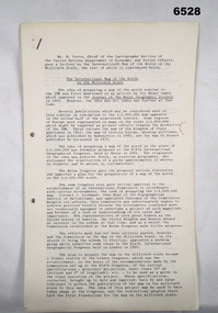
Administrative record - International Map of the World (IMW) 1:1 Million Scale - H Ureta, Circa 1964, MR H Ereta, Post 1964
... International Map of the World (IMW) 1:1 Million Scale - H Ureta, Circa 1964...International Map of the World (IMW) 1:1 Million Scale - H Ureta, Circa 1964...This document records the history of the International Map of the World (IMW) at 1:1Million Scale. Mr H. ...International Map of the World (IMW) 1:1 Million Scale - H Ureta, Circa 1964 Administrative record International Map of the World (IMW) 1:1 Million Scale - H Ureta, Circa 1964 MR H Ereta ...This document records the history of the International Map of the World (IMW) at 1:1Million Scale. Mr H. Ereta, Chief of the Cartographic Section of the United Nations Department of Economic Development and Social Affairs gave a lecture on the IMW and described the history and development of the map series in post 1964. This document is a copy of that lecture. 7 x Foolscap pages of typed text, stapled and two hole punched, Paper is dis-coloured.royal australian survey corps, rasvy, fortuna, army survey regiment, army svy regt, asr, imw -
 Flagstaff Hill Maritime Museum and Village
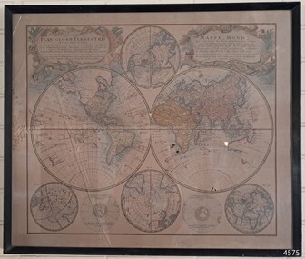
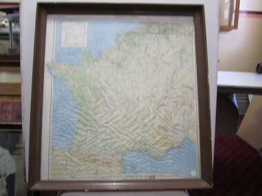
Map - World Map, Mappe Monde [Medieval Map of the World], 1910
... World Map...Mappe Monde [Medieval Map of the World]......World Map...Map behind glass in dark brown wooden frame on beige paper. The Coloured hand drawn line drawings show different hemispheres of the known world in the mid-18th century. ..."PLANIGLOBIL TERRESTRIS" "MDCCXXXXVI" [1746] "MAPPE_MONDE" [Medieval Map of the World] "LEISURE ARTS LTD" "Printed in England"...Mappe Monde [Medieval Map of the World] Map World Map ...This map from the mid-18th century doesn't include the finer details of land and sea masses that we know today. The map was produced by German cartographer and publisher, Johann Baptist Homann (1663-1724) and published in 1746, after his death. Earlier versions were published, such as 1707 and 1716. The date can be calculated from the Roman numerals on the top left text area. This print of a map is significant for its connection with early world explorers. A comparison of maps over the centuries shows the progression of navigational technology, the countries who claimed the land they explored. The naming of even some Australian locations shows who had already made their mark on Australia in the early 18th century. The print shows the fine details included by the cartographer and the beauty included that makes it attractive and interesting even today. The map is also significant for its connection with German cartographer, Johann Baptist Homann, whose Homann publishing company was renewed in Germany for producing high quality maps and atlases. Map behind glass in dark brown wooden frame on beige paper. The Coloured hand drawn line drawings show different hemispheres of the known world in the mid-18th century. Beautifully drawn figures and decorative embellishments enhance the map. The text on the top right has an explanation of the Figures I, II, III, and IV. This print of the 1746 map was produced in England by Leisure Arts Ltd. "PLANIGLOBIL TERRESTRIS" "MDCCXXXXVI" [1746] "MAPPE_MONDE" [Medieval Map of the World] "LEISURE ARTS LTD" "Printed in England"flagstaff hill, warrnambool, flagstaff hill maritime museum, flagstaff hill maritime village, flagstaff hill maritime museum and village, shipwreck coast, world map, french map, 18th century map, leisure arts ltd, cartography, early exploration, cartographer, johann homann (1663-1724), exploration, naviagtion, 1746 planiglobil terrestris -
 Ballarat Heritage Services
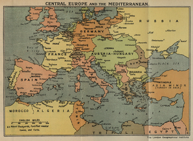
Map, Central Europe and the Mediterranean during World War One
... Map of the World...Map of the World as it was during World War One. ...Ballarat Heritage Services PO Box 2209 Bakery Hill Post Office goldfields Map of the World World War One France Spain England Ireland germany Austria-Hungary Rumania Servia Albania Greece Bulgaria Russia Asia Minor Turkey Egypt Tripoli Morocco Algeria Tunis Map of the World as it was during World War One. ...Map of the World as it was during World War One. map of the world, world war one, france, spain, england, ireland, germany, austria-hungary, rumania, servia, albania, greece, bulgaria, russia, asia minor, turkey, egypt, tripoli, morocco, algeria, tunis -
 Tatura Irrigation & Wartime Camps Museum
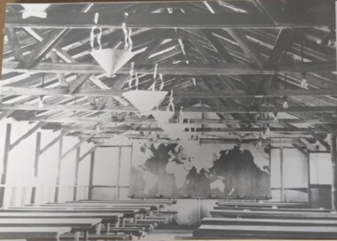
Photograph, Camp 13 Hall, 1941
... ...map of the world...Black and white photograph of inside of Camp 13 hall. Map of the world, Australia and Pacific Ocean backdrop. ...Map of the world, Australia and Pacific Ocean backdrop. ...Inside view of Camp 13 hallBlack and white photograph of inside of Camp 13 hall. Map of the world, Australia and Pacific Ocean backdrop. Tables and stools, inserted conical lights.camp 13, camp 13 hall, map of the world -
 Stawell Historical Society Inc
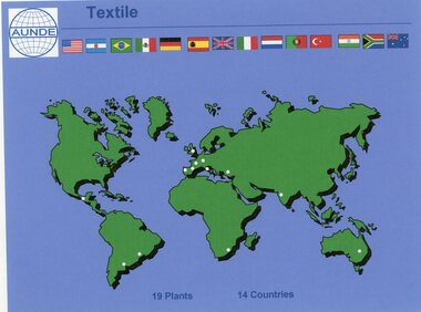
Photograph - Aunde Album 29, Textile Plants, 2002
... Colour landscape photo: Map of the world dots of locations and countries maps....Colour landscape photo: Map of the world dots of locations and countries maps. ...Aunde / Norwellan Textiles North Western Woollen Mills became Norwellan Textiles then AUNDEColour landscape photo: Map of the world dots of locations and countries maps.Textile AUNDE logo 19 Plants, 14 Countries.industry, aunde -
 Warrnambool and District Historical Society Inc.
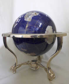
Decorative object - Trophy, World globe horseracing trophy
... Large sphere map of the world. Blue in colour with world map. ...Warrnambool and District Historical Society Inc. 2 Gilles Street (south of Merri St) Warrnambool great-ocean-road Won by thoroughbred horse Mega Pixel at the Warrnambool May carnival warrnambool horse racing globe may carnival Mega Pixel Large sphere map of the world. Blue in colour with world map. ...Won by thoroughbred horse Mega Pixel at the Warrnambool May carnivalLarge sphere map of the world. Blue in colour with world map. Supported on standwarrnambool, horse racing, globe, may carnival, mega pixel -
 Seaworks Maritime Museum
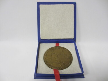
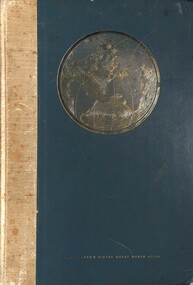
Medallion
... Bronze mellion featuring image of ship on one side and map of the world on the other ...Seaworks Maritime Museum 82 Nelson Place Williamstown melbourne "Merchant Marine Academy/ Goynia/ Poland/ Dar Mzodzieey" Verso "Round the World Voyage/ Tall ship Races Hobart- Sydney" PMA 0291 WMA 76 Bronze mellion featuring image of ship on one side and map of the world on the other Medallion ...Bronze mellion featuring image of ship on one side and map of the world on the other "Merchant Marine Academy/ Goynia/ Poland/ Dar Mzodzieey" Verso "Round the World Voyage/ Tall ship Races Hobart- Sydney" PMA 0291 WMA 76 -
 Sunshine and District Historical Society Incorporated
Book, Reader's Digest, The Reader's Digest Great World Atlas
... Large green hard covered book with a map of the world & text printed in gold...Brimbank Library, 301 Hampshire Road, Sunshine 3020. melbourne Atlas The Reader's Digest Great World Atlas|Reece Carland 3 Leith Ave Sunshine inscribed inside the front cover Large green hard covered book with a map of the world & text printed in gold The Reader's Digest Great World Atlas Book Reader's Digest ...Large green hard covered book with a map of the world & text printed in goldatlas -
 Harcourt Valley Heritage & Tourist Centre
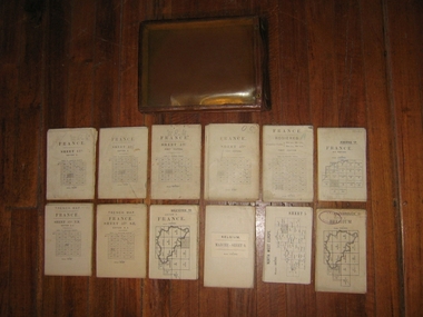
Field maps in case, 1914
... Maps used in World War I by Col W E James...Collection of 12 fold up war maps from Europe used during World War I; on linen backing. ...Collection of 12 fold up war maps from Europe used during World War I; on linen backing. ...Maps used in World War I by Col W E JamesPart of a large collection of items belonging to Col, W E James, of Harcourt, who after a career in the Militia, commanded Australian troops in WW1, both at Gallipoli and on the western Front. The entire collection includes books on military law and maps. Essential part of the commanding officer’s kit. Collection of 12 fold up war maps from Europe used during World War I; on linen backing. Brown leather case, transparent front cover, brass fastenings and loop for attaching to the belt -
 Port Melbourne Historical & Preservation Society
Map - Route of US Navy Great White Fleet, 2008
... Large photocopy of map of the world with the route of the Great White Fleet (US Navy) 1908 marked in red and white tape...Port Melbourne Historical & Preservation Society Port Melbourne Town Hall 333 Bay Street Port Melbourne melbourne armed services - navy great white fleet us navy Large photocopy of map of the world with the route of the Great White Fleet (US Navy) 1908 marked in red and white tape Map Route of US Navy Great White Fleet ...Large photocopy of map of the world with the route of the Great White Fleet (US Navy) 1908 marked in red and white tapearmed services - navy, great white fleet, us navy -
Moorabbin Air Museum
Souvenir (item) - Pan Am map of world flights 1980
... Pan Am map of world flights 1980...Pan Am map of world flights 1980...foolscap paper map of world flights...Moorabbin Air Museum Moorabbin Airport 12 First Street Moorabbin melbourne foolscap paper map of world flights Pan Am map of world flights 1980 Souvenir Pan Am map of world flights 1980 ... -
Tatura Irrigation & Wartime Camps Museum
Photograph - copy, 1989 copy
... Interior of camp assembly hall. Map of the world covering end wall. Decorations hanging from ceiling rafters....Interior of camp assembly hall. Map of the world covering end wall. Decorations hanging from ceiling rafters. ...Copy of original black and white photograph hut used for assembly of POW's.Copy of black and white photograph. Interior of camp assembly hall. Map of the world covering end wall. Decorations hanging from ceiling rafters.camp 13, murchison victoria, internment camps, internment camp buildings -
 Disability Sport & Recreation Victoria
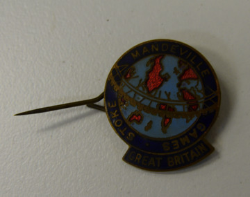
Lapel pin, Stoke-Mandeville Games - Great Britain lapel pin
... Image of the map of the world, light blue oceans, bright red abstract outlines of continents. ...Disability Sport & Recreation Victoria 33-37 Hotham Street Collingwood Stoke-Mandeville Games Image of the map of the world, light blue oceans, bright red abstract outlines of continents. ...Round lapel pin.Image of the map of the world, light blue oceans, bright red abstract outlines of continents. Surrounded by navy blue border with STOKE MANDEVILLE GAMES GREAT BRITAIN written in gold.stoke-mandeville games -
 Bendigo Military Museum
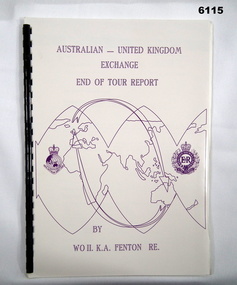
Administrative record - Australian - United Kingdom Exchange End of Tour Report by WO2 KA Fenton RE 1990, WO2 KA Fenton RE, 25.10.1990
... An A4 Booklet stylised map of the world with Corps Badges foe RASvy and Royal Engineers (UK), back cover overhead aerial Photo of Army Svy Regt, 14 Pages, 4 Annexes and an enclosure...Royal Australian Survey Corps RASvy Fortuna Army Survey Regiment Army Svy Regt ASR An A4 Booklet stylised map of the world with Corps Badges foe RASvy and Royal Engineers (UK), back cover overhead aerial Photo of Army Svy Regt, 14 Pages, 4 Annexes and an enclosure Australian - United Kingdom Exchange End of Tour Report by WO2 KA Fenton RE 1990 Administrative record Australian - United Kingdom Exchange End of Tour Report by WO2 KA Fenton RE 1990 WO2 KA Fenton RE ...A 2 x year personnel exchange program existed between RASvy and the Survey elements of the Royal Engineers UK. This is an end of Tour Report produced by WO2 KA Fenton RE of his experiences during his exchange tour. An A4 Booklet stylised map of the world with Corps Badges foe RASvy and Royal Engineers (UK), back cover overhead aerial Photo of Army Svy Regt, 14 Pages, 4 Annexes and an enclosureroyal australian survey corps, rasvy, fortuna, army survey regiment, army svy regt, asr -
Glenelg Shire Council Cultural Collection
Photograph - Photograph - Portland Harbour Trust, n.d
... Black & white photo of a wall map of the world with lines connecting various countries. ...Glenelg Shire Council Cultural Collection History House Cliff Street Portland great-ocean-road Port of Portland Authority Archives Port of Portland Archives Portland Harbour Trust Black & white photo of a wall map of the world with lines connecting various countries. ...Port of Portland Authority Archivesport of portland archives, portland harbour trust -
 Bendigo Military Museum
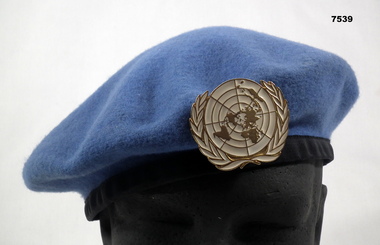
Headwear - BERET, UNITED NATIONS, Christies (Kent Brand)
... Badge features a map of the world surrounded by a laurel wreath. White Manufacturers' label sewn onto band. ...Badge features a map of the world surrounded by a laurel wreath. White Manufacturers' label sewn onto band. ...Beret belonging to "Gordon Bruce Bearman". See Catalogue No. 7538 for service details.Light blue woollen beret with black band. White and gold metal badge attached to front. Badge features a map of the world surrounded by a laurel wreath. White Manufacturers' label sewn onto band. Brand name printed in white on inside.Printed on inside in white: "KENT, PURE WOOL, X-LARGE" beret, united nations peacekeeping, insignia, gordon bruce bearman -
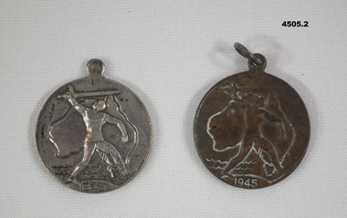 Bendigo Military Museum
Memorabilia - VICTORY MEADALLION 1945, c.1945
... .1) .2) Medallion, metal, circular with a section at top for a ring, front face has depiction map of Australia with a figure holding a sword overhead, year date at bottom, rear has a styalized map of the World, , a small depiction of a boat, whale, writing stamped in....Bendigo Military Museum 37 - 39 Pall Mall Bendigo goldfields Medallions Victory 1945 On front, "1945", on rear, "Victory Medal" .1) .2) Medallion, metal, circular with a section at top for a ring, front face has depiction map of Australia with a figure holding a sword overhead, year date at bottom, rear has a styalized map of the World, , a small depiction of a boat, whale, writing stamped in. ....1) .2) Medallion, metal, circular with a section at top for a ring, front face has depiction map of Australia with a figure holding a sword overhead, year date at bottom, rear has a styalized map of the World, , a small depiction of a boat, whale, writing stamped in.On front, "1945", on rear, "Victory Medal"medallions, victory 1945 -
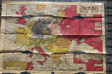 Lara RSL Sub Branch
Newspaper - The Sun Newspaper Dated 5/8/1944 -specia - World War 2 Europe Map and History Of World War 2 and Nazi Tide Flows and Ebbs Across Europe, THe Sun Newspaper Dated 5/8//1944 - Special War Maps
... The Sun Newspaper Dated 5/8/1944 -specia - World War 2 Europe Map and History Of World War 2 and Nazi Tide Flows and Ebbs Across Europe...world war 2 europe map and hisytory of world war 2 and nazi tide flows and ebbs across europe...Local Newspaper Dated 5/8/1944 - Special World War 2 Maps... World War 2 Europe Map and History Of World War 2 and Nazi Tide Flows and Ebbs Across Europe...Lara RSL Sub Branch McClelland Ave Lara The Sun Newspaper Dated 5/8/1944 world war 2 europe map and hisytory of world war 2 and nazi tide flows and ebbs across europe World War 2 Europe Map and History Of World War 2 and Nazi Tide Flows and Ebbs Across Europe Local Newspaper Dated 5/8/1944 - Special World War 2 Maps THe Sun Newspaper Dated 5/8//1944 - Special War Maps Newspaper The Sun Newspaper Dated 5/8/1944 -specia - World War 2 Europe Map and History Of World War 2 and Nazi Tide Flows and Ebbs Across Europe ...The Sun Newspaper Dated 5/8/1944 Local Newspaper Dated 5/8/1944 - Special World War 2 Maps World War 2 Europe Map and History Of World War 2 and Nazi Tide Flows and Ebbs Across Europeworld war 2 europe map and hisytory of world war 2 and nazi tide flows and ebbs across europe -
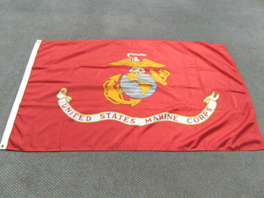 National Vietnam Veterans Museum (NVVM)
Flag, United States Marine Corps
... Red nylon flag featuring yellow and white eagle, standing on a gray round map of the world featuring North and South America in yellow. ...National Vietnam Veterans Museum (NVVM) 25 Veterans Drive Newhaven phillip-island-and-the-bass-coast Flag United States - Marine Corps United States Marine Corps Red nylon flag featuring yellow and white eagle, standing on a gray round map of the world featuring North and South America in yellow. ...Red nylon flag featuring yellow and white eagle, standing on a gray round map of the world featuring North and South America in yellow. Large banner on bottom of flag saying "United States Marine Corps" Also around the world globe is an anchor and rope also in yellowUnited States Marine Corpsflag, united states - marine corps -
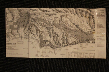 Lara RSL Sub Branch
Group of Maps World War One, Group of Maps World War One - Dardanelles and Anzac Gallipoli Maps Circ 1915, Circ 1916
... Gallipoli 1915 Maps and Naval plan of Operations World War One ANZAC...(and copy).. 4. Map of ANZAC Trench Diagram. World War One.Color. (and copy). 5.Panorama of Chunuk Blair from 3 miles south of Nibrunesi Point, 3 November 1915 and Anzac from 1 mile N. ...Australian War Memorial, 6. Map of ANZAC positions of World War One, Gallipoli 1915. ...Color Map of ANZAC positions with topographical Details, notes. Group of Maps World War One - Dardanelles and Anzac Gallipoli Maps Circ 1915 Group of Maps World War One ...Gallipoli 1915 Maps and Naval plan of Operations World War One ANZACRare examples that explain both ANZAC and Naval Operations during World War One Gallipoli & Dardanelles Passage .!. Black and White Photocopy of Gallipoli 1915 ANZAC Battlefield - detailed positions of troops and Cemeteries. 2.The Allied Failure to Force The Dardanelles Passage 18 March 1915 - detailed line of Attack Naval Organisation, Mine layout, Plan of Attack (and copy).. 3. Map of Turkey and surrounding area written in Turkish and German Languages. C0olor version main roads and distances. (and copy).. 4. Map of ANZAC Trench Diagram. World War One.Color. (and copy). 5.Panorama of Chunuk Blair from 3 miles south of Nibrunesi Point, 3 November 1915 and Anzac from 1 mile N. E. of Ari Burnu, 21 November 1915. Black & White 6. Color Map of ANZAC positions with topographical Details, notes. 1. Artwork and copyright by Srewart Cownie, Gallipoli 1915 ANZAC Battlefield with Landings and later evacuation marked. 2. Details of Naval actions taken in the Dardanelles Passage 18 March 1918. 3. Local area Map or Turkey. Shows roads network and townships. 4. ANZAC Trench Diagram, copyright Whitcombe & Tombs Limited , Wellington N.Z. 1919 5. Panorama of two coast views of ANZAC area. Australian War Memorial, 6. Map of ANZAC positions of World War One, Gallipoli 1915. Published by H.E.C. Roberinson, George Street, Sydney N.S.W.18 April 1916maps operational of anzac and naval opations during 1915 etc, dardanelles naval opations -
 Returned Nurses RSL Sub-branch
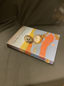
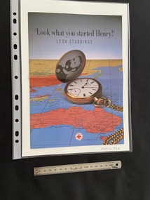
Book, Leon Stubbings, 'Look what you started Henry!' : A history of the Australian Red Cross 1914-1991, 1992
... Paperback book with a bluish grey cover and a map of the world, predominantly showing Australia, on the front cover and spine. ...[Typed in the centre of the slip] 'Leon Stubbings' [ Handwritten signature of the author in black ink at the bottom of the compliments slip] 'B115' [Handwritten in blue pen in the top right corner of the second page] Paperback book with a bluish grey cover and a map of the world, predominantly showing Australia, on the front cover and spine. ...The book shows how ordinary people made a significant contribution to the well being of others, from the help the Red Cross has given during both world wars, to the international blood transfusion service and youth movements. (From Trove record)Paperback book with a bluish grey cover and a map of the world, predominantly showing Australia, on the front cover and spine. Main heading is in black text and subheading is in white text (cover) and red text (spine). There is an open gold pocket watch on the map with a black and white photo of a gentleman displayed inside.non-fictionThe book shows how ordinary people made a significant contribution to the well being of others, from the help the Red Cross has given during both world wars, to the international blood transfusion service and youth movements. (From Trove record)australian red cross, world war 1, world war 2, ww1, ww2, wwi, wwll -
 Returned Nurses RSL Sub-branch
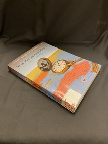
Book, Leon Stubbings, 'Look what you started Henry!' : A history of the Australian Red Cross 1914-1991, 1992
... Paperback book with a bluish grey cover and a map of the world, predominantly showing Australia, on the front cover and spine. ...(From Trove record) [Typed dedication sticky taped inside front cover, see media for contents] Paperback book with a bluish grey cover and a map of the world, predominantly showing Australia, on the front cover and spine. ...The book shows how ordinary people made a significant contribution to the well being of others, from the help the Red Cross has given during both world wars, to the international blood transfusion service and youth movements. (From Trove record)Paperback book with a bluish grey cover and a map of the world, predominantly showing Australia, on the front cover and spine. Main heading is in black text and subheading is in white text (cover) and red text (spine). There is an open gold pocket watch on the map with a black and white photo of a gentleman displayed inside.non-fictionThe book shows how ordinary people made a significant contribution to the well being of others, from the help the Red Cross has given during both world wars, to the international blood transfusion service and youth movements. (From Trove record)australian red cross, world war 1, world war 2, ww1, ww2, wwi, wwll -
 Wangaratta RSL Sub Branch
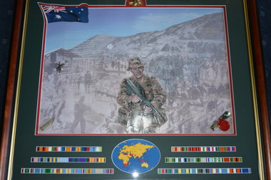
Mixed media - Framed Print
... Image of Rising Sun Badge centered at top , Australian Flag left top corner, three rows of campaign ribbons either side of circular map of the world across the bottom....Image of Rising Sun Badge centered at top , Australian Flag left top corner, three rows of campaign ribbons either side of circular map of the world across the bottom. Mixed media Framed Print 4 Corners Picture Framing ...Image of Australian Soldier together with map of conflicts fought and campaign ribbons Dark timber frame with gold edging depicting sketch of Aussie Diggers with campaign ribbons 1901-2001. Image of Rising Sun Badge centered at top , Australian Flag left top corner, three rows of campaign ribbons either side of circular map of the world across the bottom.The Australian Army 1901-2001 "The Spirit - Ordinary people - Extraordinary Service"campaign ribbons, australian army, 1901-2000 -
 Greensborough Historical Society
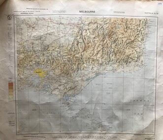
Map, Australia. Department of Minerals and Energy, Melbourne, topographic map, 1970_
... International map of the world [scale] 1:1,000,000. Prepared by the Department of Minerals and Energy, Canberra in 1970....International map of the world [scale] 1:1,000,000. Prepared by the Department of Minerals and Energy, Canberra in 1970. ...A topographic map of Victoria with Melbourne as the centre. Provisional edition showing contours in feet. International map of the world [scale] 1:1,000,000. Prepared by the Department of Minerals and Energy, Canberra in 1970.A pre-metric map, shows the Hume Highway travelling through towns such as Seymour and Benalla, now by-passed by the Hume Freeway.Map, printed in colour on one side.victoria - maps -
 Returned Nurses RSL Sub-branch
Pamphlet - Australian Red Cross pamphlet, Australian Red Cross Society, 'Look what you started Henry!', 1992
... Bluish grey bi-fold pamphlet with a map of the world, predominantly showing Australia, on the front and the title printed across the top of the page in black print. ...The collection is linked through the association of the participants living in the Diamond Valley area in Melbourne's north in 1995. " - Eltham District Historical Society Australian Red Cross Leon Cummings Bluish grey bi-fold pamphlet with a map of the world, predominantly showing Australia, on the front and the title printed across the top of the page in black print. ...Pamphlet promoting the book: 'Look what you started Henry!' with an order coupon for the book included. There is also some printed history of the Australian Red Cross Society and of Leon Stubbings (the author of the book)."This book comprises a collection of unique and individual personal narratives of World War 2, written 50 years after the war and preserved for future generations. The collection is linked through the association of the participants living in the Diamond Valley area in Melbourne's north in 1995. " - Eltham District Historical SocietyBluish grey bi-fold pamphlet with a map of the world, predominantly showing Australia, on the front and the title printed across the top of the page in black print. There is an open gold pocket watch on the map with a black and white photo of a gentleman displayed inside. The pamphlet opens to a double page of information in the middle and further information and an order coupon on tha back.australian red cross, leon cummings -
 Glenelg Shire Council Cultural Collection
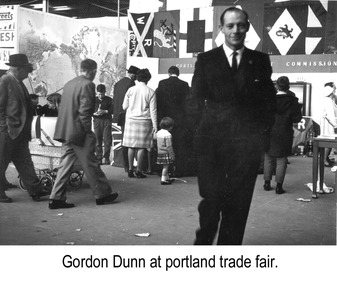
Photograph - Photograph - Gordon Dunn, Publicity Officer, Portland Harbour Trust at Portland Trade Fair, n.d
... A stand on the left has a large map of the world on display, and a stand to the background right has a series of flag, and below this a sign with the words "Portl... ...A stand on the left has a large map of the world on display, and a stand to the background right has a series of flag, and below this a sign with the words "Portl... ...Port of Portland Authority archivesFront: (no inscriptions) Back: Gordon Dunn/ Publicity Officer PHT (blue pen, centre)port of portland authority archives -
Glenelg Shire Council Cultural Collection
Book - Book - Simple Studies in British History, William Gillies M. A, n.d
... British History textbook, black and white photos, map of world first pages, British Empire shown in red....British History textbook, black and white photos, map of world first pages, British Empire shown in red. ...Hardback, brown, black print. British History textbook, black and white photos, map of world first pages, British Empire shown in red. -
 Flagstaff Hill Maritime Museum and Village
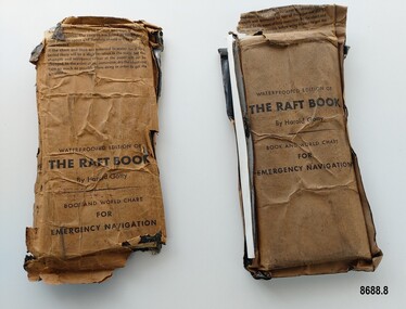
Booklet - Book and World Chart for Emergency Navigation, George Grady Press, The Raft Book, 1943
... World War Gatty was given the honorary rank of Group Captain in the Royal Australian Air Force (RAAF) and worked for the U. S. Army Air Forces (USAAF) in the South Pacific. In 1943 he moved to Washington where he developed a survival book (The Raft Book) specifically for boat crews or air crews flying over the Pacific to help them survive and navigate their life rafts in remote areas of the ocean. The original book was 152 pages long however a condensed version was made which consisted of a 64 page booklet, combined map...Each packet contains a folded 64 page paper booklet with detailed instructions for navigating a small craft in open seas, a folded chart (with a map of the world and oceans, well known constellations, latitude and longitude charts, Greenwich time and a scale for string lengths and Harp scale) and a long folded paper calendar strip....Each packet contains a folded 64 page paper booklet with detailed instructions for navigating a small craft in open seas, a folded chart (with a map of the world and oceans, well known constellations, latitude and longitude charts, Greenwich time and a scale for string lengths and Harp scale) and a long folded paper calendar strip. ...Harold Gatty was born on January 5th, 1903 in Campbell Town, Tasmania. He was a navigator and aviation pioneer. He began his career learning navigation at the age of 14 as a midshipman at the Royal Australian Naval College but withdrew after three years and became an apprenticed ship's officer with the Patrick Steamship Company of Sydney. After W. W. 1 he joined the Australian Merchant Navy where he learned the constellations while standing night watch and became an expert in celestial navigation while serving on many ships sailing between Australia and California. In 1927 he moved to California and opened a navigation school and also a laboratory repairing navigational equipment. At this time he became very interested in air navigation and was aware of the limitations of existing methods and instruments for aerial navigation. He began researching ways of improving aerial navigation. Two early inventions of his were his air sextant and a ground speed and drift indicator which formed the basis of the automatic pilot which later came to be standard equipment on most aircraft. He worked with several record breaking pilots including Ann Morrow Lindbergh (who went on to serve as a navigator for her husband Charles Lindbergh), helped Wiley Post break the world record circumnavigating the Earth, invented a new method of "dead reckoning" that revolutionised the ability to fly safely through cloudy conditions without drifting off course and famously navigated a small plane (whilst trying to cross the Pacific) over 1900 km through fog (with no radio) and using only his dead reckoning techniques, back to their starting point in Japan after they developed fuel problems. In 1932 Gatty received the Distinguished Flying Cross from President Hoover. In 1934 Gatty formed the South Seas Commercial Company with Donald Douglas with the aim to deliver air services to the islands of the South Pacific. The Company was sold to Pan Am but he continued to work for them. In 1935 he went on a sailing expedition investigating several small islands in the South Pacific and was briefly marooned on Baker Island. He was able to use his extensive knowledge of seabird habits to save the crew. He was also very interested in the ability of the Polynesians to navigate using the stars. During the Second World War Gatty was given the honorary rank of Group Captain in the Royal Australian Air Force (RAAF) and worked for the U. S. Army Air Forces (USAAF) in the South Pacific. In 1943 he moved to Washington where he developed a survival book (The Raft Book) specifically for boat crews or air crews flying over the Pacific to help them survive and navigate their life rafts in remote areas of the ocean. The original book was 152 pages long however a condensed version was made which consisted of a 64 page booklet, combined map and star chart and calendar strip enclosed in a waterproof slipcase, to be placed in life rafts for emergency use. The booklet included navigational advice and ideas such as ocean currents, estimation of distance, using a compass, measurement of angles, recognising and steering by the stars, land indications from sea birds, migration of sea birds and insects, sounds from the land, the scent of the land and ocean currents and the colour of the sea etc. After W.W.2 Gatty moved to Fiji and formed Fiji Airways (which later became Air Pacific). Harold Gatty died in August 1957.The two copies of "The Raft Book" are significant as they are a written summary of the many methods of sea navigation (both modern and historical) that existed in the 1940's. They are also a record of Harold Gatty, who played a significant role in the development of modern day aerial navigation using his understanding of different sea navigational techniques.Two rectangular brown packets with waterproof coverings (oiled paper) titled "The Raft Book" by Harold Gatty. Each packet contains a folded 64 page paper booklet with detailed instructions for navigating a small craft in open seas, a folded chart (with a map of the world and oceans, well known constellations, latitude and longitude charts, Greenwich time and a scale for string lengths and Harp scale) and a long folded paper calendar strip.Front of package - "WATERPROOFED EDITION OF/ THE RAFT BOOK / By Harold Gatty / BOOK AND WORLD CHART / FOR / EMERGENCY NAVIGATION / To open envelope tear along above line. If the envelope is used again fold the flap to keep contents dry. 1. This envelope contains a book, chart and tape for emergency navigation. The contents are folded to take up the least possible space and therefore should not be removed until needed. 2. if the chart and tape are immersed in water for a long period, there will be a slight variation in the scale but the strength and resistence to tear of the paper will not be changed. In the event of long immersion, dry the chart and tape as much as possible before using in order to in order to get the greatest accuracy in scale. Front of booklet - THE RAFT BOOK / LORE OF THE SEA AND SKY /By Harold Gatty IMPORTANT FOR YOUR SECURITY/Upon abandoning ship you may have to be your own navigator. Take the following pre/cautions for your own safety:/ Carry a good type of pocket watch / keep it wound and have it running on Greenwich (England) / Time, which you can get from the navigating officer. / Keep track of the date at Greenwich; and on a 24-hour basis, / know whether the time is, say, 6 hours (6 A.M.) showing on / your watch, or 18 hours (6P.M.) Greenwich. / PROECT YOUR WATCH. GET A RUBBER SACK FOR IT (OBTAIN FROM PHARMACIST) AND KEEP IT DRY / KEEP A PENCIL IN YOUR POCKET/ POSITION OF SHIP WHEN ABANDONED PRINTED IN UNITED STATES OF AMERICA GEORGE GRADY PRESS, NEW YORK/COPYRIGHT, 1943, BY HAROLD AND FENNA GATTYflagstaff hill maritime museum and village, shipwreck coast, warrnambool, the raft book, harold gatty, book and world chart for emergency navigation, ww 2, ww ii, navigation, air navigation, aerial navigation, lindbergh, wiley post, dead reckoning, south seas commercial company, u.s. army airforce, usaaf, survival book, life rafts, sea navigation, emergency navigation, fiji airways, harp scale -
 Yarrawonga and Mulwala Pioneer Museum
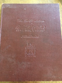
Book, The Specialty Press, The New Elizabethan World Atlas Illustrated, 1952
... Contains detailed maps of world countries in colour. Early world history and it's development and comprehensive gazetteer....Yarrawonga and Mulwala Pioneer Museum 151 Melbourne St, Mulwala Provides names of countries and their borders as they were during the 1950's Maps Owners name written in front pages Maroon hard cover illustrated atlas. Front embossed with title and royal seal. 152 pages. Contains detailed maps of world ...Provides names of countries and their borders as they were during the 1950'sMaroon hard cover illustrated atlas. Front embossed with title and royal seal. 152 pages. Contains detailed maps of world countries in colour. Early world history and it's development and comprehensive gazetteer.Owners name written in front pagesmaps -
 Ballarat RSL Sub-Branch Inc.
Photograph - "Zones of France"
... On back - "R.A.F. aircrew escape map in World War II, printed on silk, carried in trousers knee pocket, and used with compass built into brass button (left-hand thread). ...Ballarat RSL Sub-Branch Inc. 330 Heinz Lane Invermay Park goldfields Photo/Pictures Ballarat RSL Ballarat On back - "R.A.F. aircrew escape map in World War II, printed on silk, carried in trousers knee pocket, and used with compass built into brass button (left-hand thread). ...On back - "R.A.F. aircrew escape map in World War II, printed on silk, carried in trousers knee pocket, and used with compass built into brass button (left-hand thread). The object was to set the aviator in the right direction for nephoto/pictures, ballarat rsl, ballarat