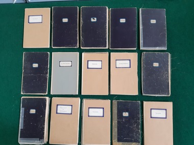
Showing 15 items matching "maps bacchus marsh region"
-
 Bacchus Marsh & District Historical Society
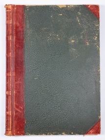
Map, Bacchus Marsh Township and Nearby Districts Maps Volume
... Maps Bacchus Marsh...Maps Bacchus Marsh Region...Maps Maps Bacchus Marsh Maps Bacchus Marsh Region One bound volume of maps comprising cadastral maps, (indicating property owners and land boundaries), land plans and real estate auction plans and advertising material, and other maps indicating major infrastructure like proposed roads and irrigation areas. ...This volume of maps is believed to have been compiled by staff at the Shire of Bacchus Marsh and was presumably used to inform and assist Shire staff and Councillors in the carriage of their duties.This collection of maps are significant due to their rarity as many of them are unique maps made for local purposes in the Bacchus Marsh region. They are also of strong research value containing a wide variety of information including landholders, land sales, infrastructure, such as roads, bridges, public, commercial and private buildings, houses, land use, and geographic features over multiple decades from the late nineteen century into the middle part of the twentieth century.One bound volume of maps comprising cadastral maps, (indicating property owners and land boundaries), land plans and real estate auction plans and advertising material, and other maps indicating major infrastructure like proposed roads and irrigation areas. Most of the maps and plans are of Bacchus Marsh and nearby areas but some maps are of nearby towns such as Melton, Ballan and Blackwood. The volume comprises 52 pages. Most pages have a single map or plan pasted onto it but some contain 2 or 3 different maps. There are 81 maps in total. Map 1 Liquidators Sale 1896. Map 2. Woodside Estate Sale 1913. maps, maps bacchus marsh, maps bacchus marsh region -
 Bacchus Marsh & District Historical Society
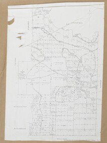
Map, Bacchus Marsh Region Parish Plans: Folded set of maps
... Maps Bacchus Marsh Region...Bacchus Marsh & District Historical Society Lerderderg Library Main Street Bacchus Marsh Maps Bacchus Marsh Region Bacchus Marsh Victoria Maps Set of Victorian Lands Department Parish Plans covering the township of Bacchus Marsh and surrounding districts. ...Set of Victorian Lands Department Parish Plans covering the township of Bacchus Marsh and surrounding districts. Folded. BMDHS Location: AR/SU27/D2: Map Drawersmaps bacchus marsh region, bacchus marsh victoria maps -
 Bacchus Marsh & District Historical Society
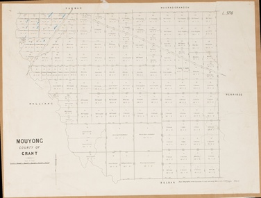
Map, Mouyong Parish Map, County of Grant
... Maps...Bacchus Marsh Region Parish Plans...Bacchus Marsh & District Historical Society Lerderderg Library Main Street Bacchus Marsh Mouyong Parish Plan Mouyong Parish Maps Bacchus Marsh Region Parish Plans Photo lithographed at the Department of Lands and Survey Melbourne by T. ...A single page paper map showing the map for the Parish of Mouyong in the County of Grant. Cadastral map showing land ownership. The map is pasted into a bound volume containing 76 maps or plans in total. High resolution digital image stored on BMDHS computer network. Photo lithographed at the Department of Lands and Survey Melbourne by T. F. McGauran, 9. 4. 07mouyong parish plan, mouyong parish maps, bacchus marsh region parish plans -
 Bacchus Marsh & District Historical Society
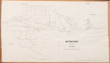
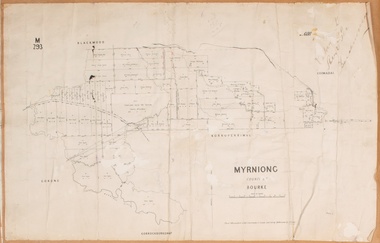
Map, Myrniong Parish Map 1904
... Maps...Bacchus Marsh Region Parish Plans...Bacchus Marsh & District Historical Society Lerderderg Library Main Street Bacchus Marsh Myrniong Parish Plan Myrniong Parish Maps Bacchus Marsh Region Parish Plans A single page paper map showing the map for the Parish of Myrniong in the County of Bourke. ...A single page paper map showing the map for the Parish of Myrniong in the County of Bourke. A cadastral map showing parish boundaries and land ownership. The map is pasted into a bound volume containing 76 maps or plans in total. High resolution digital image stored on BMDHS computer network. myrniong parish plan, myrniong parish maps, bacchus marsh region parish plans -
 Bacchus Marsh & District Historical Society
Map, Gorrockburkchap Parish Map, County of Grant c.1906
... Maps...Bacchus Marsh Region Parish Plans...Bacchus Marsh & District Historical Society Lerderderg Library Main Street Bacchus Marsh The parish of Gorrockburkchap (sometimes spelled Gorrockburkghap) lies to the west and south west of the township of Bacchus Marsh. The locality of Rowsley is situated within this parish area. Gorrockburkchap Parish Maps Rowsley Victoria Maps Bacchus Marsh Region ...The parish of Gorrockburkchap (sometimes spelled Gorrockburkghap) lies to the west and south west of the township of Bacchus Marsh. The locality of Rowsley is situated within this parish area.A single page paper map showing the parish plan for Gorrockburkchap in the County of Grant. A cadastral map showing parish boundaries and land ownership The map is pasted into a bound volume containing 76 maps or plans in total. High resolution digital image stored on BMDHS computer network. gorrockburkchap parish maps, rowsley victoria maps, bacchus marsh region parish plans -
 Bacchus Marsh & District Historical Society
Map, Myrniong Parish Map, County of Bourke, 1882
... Maps...Bacchus Marsh Region Parish Plans...Bacchus Marsh & District Historical Society Lerderderg Library Main Street Bacchus Marsh Myrniong Parish Plan Myrniong Parish Maps Bacchus Marsh Region Parish Plans Photo-lithographed at the Department of Lands and Survey, Melbourne by J. ...A single page paper map showing the map for the Parish of Myrniong in the County of Bourke. A cadastral map showing parish boundaries and land ownership. The map is pasted into a bound volume containing 76 maps or plans in total. High resolution digital image stored on BMDHS computer network. Photo-lithographed at the Department of Lands and Survey, Melbourne by J. Noone, 17.7.82myrniong parish plan, myrniong parish maps, bacchus marsh region parish plans -
 Bacchus Marsh & District Historical Society
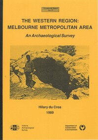
Book, The Western Region: Melbourne Metropolitan Area: An Archaeological Survey
... Bacchus Marsh, Melton and Werribee shire boundaries of the time defined the areas of the study. The study contains extensive lists of the types of artifacts found the the locations where they were found. Soft cover foolscap size book. 96 pages with b & w illustrations, images and maps (some folded). Part of Occasional reports series (Victoria Archaeological Survey) ; No. 27. Published by Department of Conservation and Environment, Melbourne, 1990. Author, Hilary Du Cros. BMDHS Loc. AR/SU5 The Western Region ...This study aimed to locate and document Aboriginal archaeological sites in the western region of Melbourne. This area was defined by the study as extending out from the western suburbs of Melbourne to the Brisbane Ranges and north beyond Bacchus Marsh. The specific aim of the study was to investigate the Aboriginal archaeology of the Western Plains area in the vicinity west of Melbourne. The Bacchus Marsh, Melton and Werribee shire boundaries of the time defined the areas of the study. The study contains extensive lists of the types of artifacts found the the locations where they were found.Soft cover foolscap size book. 96 pages with b & w illustrations, images and maps (some folded). Part of Occasional reports series (Victoria Archaeological Survey) ; No. 27. Published by Department of Conservation and Environment, Melbourne, 1990. Author, Hilary Du Cros. BMDHS Loc. AR/SU5This study aimed to locate and document Aboriginal archaeological sites in the western region of Melbourne. This area was defined by the study as extending out from the western suburbs of Melbourne to the Brisbane Ranges and north beyond Bacchus Marsh. The specific aim of the study was to investigate the Aboriginal archaeology of the Western Plains area in the vicinity west of Melbourne. The Bacchus Marsh, Melton and Werribee shire boundaries of the time defined the areas of the study. The study contains extensive lists of the types of artifacts found the the locations where they were found. aboriginal australians victoria western plains, aboriginal artifacts, archaelogical sites victoria western plains, aboriginal artifacts bacchus marsh region -
 Bacchus Marsh & District Historical Society
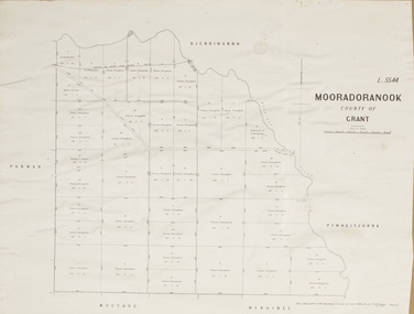
Map, Mooradoranook Parish Map, County of Grant
... Maps...Mooradoranook Parish Plan...Bacchus Marsh Region...Bacchus Marsh & District Historical Society Lerderderg Library Main Street Bacchus Marsh Mooradoranook Parish Maps Mooradoranook Parish Plan Bacchus Marsh Region Parish Plans Photo lithographed at the Department of Lands and Survey Melbourne by T. ...A single page paper map showing the map for the Parish of Mooradanook in the County of Grant. Cadastral map showing land ownership. The map is pasted into a bound volume containing 76 maps or plans in total. High resolution digital image stored on BMDHS computer network. Photo lithographed at the Department of Lands and Survey Melbourne by T. F. McGauran, 27.11.06mooradoranook parish maps, mooradoranook parish plan, bacchus marsh region parish plans -
 Bacchus Marsh & District Historical Society
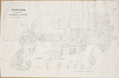
Map, Trentham Parish Map 1905 Copy 1
... Maps...Trentham Parish Plan...Bacchus Marsh Region...Bacchus Marsh & District Historical Society Lerderderg Library Main Street Bacchus Marsh Trentham Parish Maps Trentham Parish Plan Bacchus Marsh Region Parish Plans Photo-lithographed at the Department of Lands and Survey, Melbourne by T.F. ...A single page paper map showing the map for the Parish of Trentham in the Counties of Dalhousie and Bourke. A cadastral map showing parish boundaries and land ownership. The map is pasted into a bound volume containing 76 maps or plans in total. High resolution digital image stored on BMDHS computer network. Photo-lithographed at the Department of Lands and Survey, Melbourne by T.F. McGauran 22.3.05 trentham parish maps, trentham parish plan, bacchus marsh region parish plans -
 Bacchus Marsh & District Historical Society
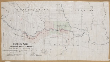
Map, General Plan for Water Supply Works, Shire of Bacchus Marsh 1887
... Bacchus Marsh Debate about water supply and its planning and development took place in the Bacchus Marsh region from the 1850s through into the twentieth century. This plan was part of documentation to support an application for an additional loan of money from the Ministry of Water Supply to the Bacchus Marsh Shire Water Supply Trust. The plan includes the route of a proposed water channel in the Parwan area, and other features of water supply infrastructure such as the location of standpipes and gates are also shown on the plan. Water Supply Water Supply Maps ...Debate about water supply and its planning and development took place in the Bacchus Marsh region from the 1850s through into the twentieth century. This plan was part of documentation to support an application for an additional loan of money from the Ministry of Water Supply to the Bacchus Marsh Shire Water Supply Trust. The plan includes the route of a proposed water channel in the Parwan area, and other features of water supply infrastructure such as the location of standpipes and gates are also shown on the plan.A single page paper map showing a general plan for the supply of water in the Bacchus Marsh area.The plan shows the route of the 'Main Channel' near the Werribee River and a proposed route for a Parwan Channel. The location of 'Dryden's House' near the Werribee River is also shown and the locations of land held by T. (Tom) Oliver and the Racecourse Reserve in Maddingley. Scale 40 chains to 1 inch. The plan is signed by Bacchus Marsh Shire Engineer, W.E. Standfield. The map is pasted into a bound volume containing 76 maps or plans in total. High resolution digital image stored on BMDHS computer network. General Plan of Water Supply Works in the Shire of Bacchus Marsh. Accompanying application for 2nd additional Loan. Original Waterworks district. Additional area. W.E. Standfield, 30/8/87.water supply, water supply maps, water supply bacchus marsh, irrigation, bacchus marsh victoria maps -
 Bacchus Marsh & District Historical Society
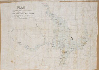
Map, Plan of part of the road district of Bacchus Marsh circa 1856-1862
... map was to shown the irrigable land in the district and the sources from which water for irrigation could be drawn. Bacchus Marsh was an early irrigation district in Victoria. Irrigation trusts were formed in the 1880s and 1890s to manage irrigation districts. But this was the culmination of many years of earlier attempts to construct irrigation systems in the Bacchus Marsh area and create a system to manage irrigation more broadly. This map dating from around 1856-1862 is an important cartographic document which provides evidence of how the early planning for irrigation was developing in the Bacchus Marsh region ...Local government in much of Victoria including the Bacchus Marsh area began with the formation of 'local committees'. These local committees could make representations to a Central Road Board regarding plans for road construction. Road construction and maintenance were seen as the essential tasks of these early local government authorities. By 1856 the local committee in Bacchus Marsh was constituted as the Bacchus Marsh Road District. This entity continued until 1862 when the name changed to the Bacchus Marsh and Maddingley Road District. This new entity lasted until 1871 when the local government authority in accordance with new statewide legislation became known as the Shire of Bacchus Marsh. The title of this plan being a plan of 'a portion of the road district of Bacchus Marsh' suggests that the plan was produced sometime between 1856 and 1862. The main purpose of this map was to shown the irrigable land in the district and the sources from which water for irrigation could be drawn. Bacchus Marsh was an early irrigation district in Victoria. Irrigation trusts were formed in the 1880s and 1890s to manage irrigation districts. But this was the culmination of many years of earlier attempts to construct irrigation systems in the Bacchus Marsh area and create a system to manage irrigation more broadly. This map dating from around 1856-1862 is an important cartographic document which provides evidence of how the early planning for irrigation was developing in the Bacchus Marsh region.A single page paper map showing a plan of part of the road district of Bacchus Marsh. The map is pasted into a bound volume containing 76 maps or plans in total. High resolution digital image stored on BMDHS computer network. bacchus marsh victoria maps, bacchus marsh road district, local government, road districts, irrigation -
 Bacchus Marsh & District Historical Society
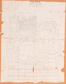
Map, Parwan Parish Map, County of Grant, 1909
... Bacchus Marsh & District Historical Society Lerderderg Library Main Street Bacchus Marsh Bacchus Marsh Region Parish Plans Parwan Parish Maps Parwan Parish Plan Photo-lithographed at the Department of Lands and Survey, Melbourne by T.F. ...A single page paper map showing the map for the Parish of Parwan in the County of Grant. A cadastral map showing parish boundaries and land ownership. The map is pasted into a bound volume containing 76 maps or plans in total. High resolution digital image stored on BMDHS computer network. Photo-lithographed at the Department of Lands and Survey, Melbourne by T.F. McGauran, 7.7.09. bacchus marsh region parish plans, parwan parish maps, parwan parish plan -
 Bacchus Marsh & District Historical Society
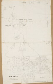
Map, Blackwood Parish Map, County of Bourke, 1892
... Bacchus Marsh & District Historical Society Lerderderg Library Main Street Bacchus Marsh Bacchus Marsh Region Parish Plans Blackwood Parish Plan Blackwood Parish Maps Photo-lithographed at the Department of Lands and Survey, Melbourne by T.F. ...A single page paper map showing the map for the Parish of Blackwood in the County of Bourke. A cadastral map showing parish boundaries and land ownership. The map is pasted into a bound volume containing 76 maps or plans in total. High resolution digital image stored on BMDHS computer network. Photo-lithographed at the Department of Lands and Survey, Melbourne by T.F. McGauran 14.7.92bacchus marsh region parish plans, blackwood parish plan, blackwood parish maps -
 Bacchus Marsh & District Historical Society
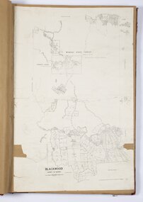
Map, Blackwood Parish Map, County of Bourke, 1905
... Bacchus Marsh & District Historical Society Lerderderg Library Main Street Bacchus Marsh Bacchus Marsh Region Parish Plans Blackwood Parish Plan Blackwood Parish Maps Photo-lithographed at the Department of Lands and Survey, Melbourne by T.F. ...A single page paper map showing the map for the Parish of Blackwood in the County of Bourke. A cadastral map showing parish boundaries and land ownership. The map is pasted into a bound volume containing 76 maps or plans in total. High resolution digital image stored on BMDHS computer network. Photo-lithographed at the Department of Lands and Survey, Melbourne by T.F. McGauran 21.7.05bacchus marsh region parish plans, blackwood parish plan, blackwood parish maps -
 Bacchus Marsh & District Historical Society
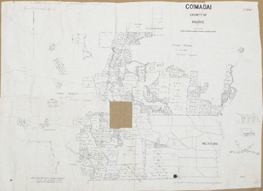
Map, Coimadai Parish Map, County of Bourke. Circa 1890s-1900s
... Bacchus Marsh & District Historical Society Lerderderg Library Main Street Bacchus Marsh The cadastral Parish of Coimadai, a subdivision of the County of Bourke, lies directly north of the township of Bacchus Marsh. The date of this map is uncertain. T.F. McGauran the person who made a photo-lithographic copy of the map was in charge of photo-lithography at the Victorian Department of Lands and Survey in the late 19th century until about 1910. Bacchus Marsh Region ...The cadastral Parish of Coimadai, a subdivision of the County of Bourke, lies directly north of the township of Bacchus Marsh. The date of this map is uncertain. T.F. McGauran the person who made a photo-lithographic copy of the map was in charge of photo-lithography at the Victorian Department of Lands and Survey in the late 19th century until about 1910.A single page paper map showing the map for the Parish of Coimadai in the County of Bourke. A cadastral map showing parish boundaries and land ownership. A rectangle shaped area is missing from the centre of the map due to a tear or deliberate excision. The map is pasted into a bound volume containing 76 maps or plans in total. High resolution digital image stored on BMDHS computer network. Photo-lithographed at the Department of Lands and Survey, Melbourne by T.F. McGauran 26.8.[??] NOTE. Photo litho from L.P showing temporary surveys and occupation of land prepared for departmental use onlybacchus marsh region parish plans, coimadai parish maps, coimadai parish plan