Showing 226 items matching "maps of germany"
-
 Bendigo Historical Society Inc.
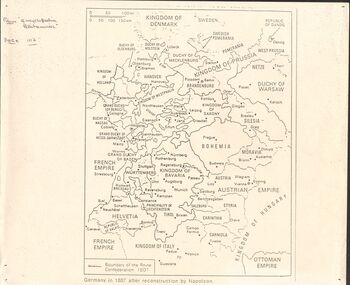
Document - GERMAN HERITAGE SOCIETY COLLECTION: MAPS OF GERMANY
... GERMAN HERITAGE SOCIETY COLLECTION: MAPS OF GERMANY...German Heritage Society Collection - Maps of Germany...Item 21. Maps of Germany. Germany in 1807 after reconstruction by Napoleon, Germany, Map of Germany States with their Coat of Arms, Thirty Years War Map 21b,Europe in the Time of Henry VIII, Europe in The Time of James I and Charles I, Europe at the End of the 15th Century, Boundaries before 1918 showing Kingdoms, Duchies, provinces, etc., of the Former German Empire (2 copies), Two Grosser Plan Vor Hamburg. ...History House 11 Mackenzie Street Bendigo goldfields DOCUMENT Certificate Map of Germany German Heritage Society Collection - Maps of Germany Theodor W Brandt's Verlag Item 21. ...Item 21. Maps of Germany. Germany in 1807 after reconstruction by Napoleon, Germany, Map of Germany States with their Coat of Arms, Thirty Years War Map 21b,Europe in the Time of Henry VIII, Europe in The Time of James I and Charles I, Europe at the End of the 15th Century, Boundaries before 1918 showing Kingdoms, Duchies, provinces, etc., of the Former German Empire (2 copies), Two Grosser Plan Vor Hamburg. Photocopies of Der Rodingsmarkt Hamburg, Kehrwieder Hamburg and Rathhausmarkt und Borse Hamburg. Photocopy of Silesia's Place in History,document, certificate, map of germany, german heritage society collection - maps of germany, theodor w brandt's verlag -
 Bendigo Historical Society Inc.
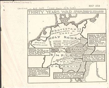
Document - GERMAN HERITAGE SOCIETY COLLECTION: MAPS OF GERMANY (PERIODS OF CHANGE)
... GERMAN HERITAGE SOCIETY COLLECTION: MAPS OF GERMANY (PERIODS OF CHANGE)......Maps of Germany...Item 21. Maps of Germany (Periods of Change) held in two buff coloured commerce folders. ...Maps of Germany (Periods of Change) held in two buff coloured commerce folders. ...Item 21. Maps of Germany (Periods of Change) held in two buff coloured commerce folders. Name written on the front in purple. Three loose copies of the Thirty Years War Map 21a, 21c and 21d. Maps of the Thirty Years War,Europe at the End of the 15th Century, The Reformation in Europe (16th Century), /Europe in the Time of Charles II & James II, The Domination of France 1660 - 85, Europe in the Time of Henry VIII, Germany in 1807 after reconstruction by Napoleon, German Federation 1815, The German Federation 1815, The German Empire of 1871, The Growth of the German Zollverein, Boundaries Before 1918 showing Kingdoms, Duchies, Provinces, etc., of the Former German Empire, the German Empire (1871 - 1918), and Boundaries before 1918 showing Kingdoms, Duchies, Provinces, etc., of the Former German Empire. The last page has a small map of Europe, a small map showing East and West Berlin, German Coats of Arms, Comparative International Figures of Population and a short article titled 'Do You Know Germany'.document, certificate, maps of germany, german heritage society collection - maps of germany (periods of change) -
 Lara RSL Sub Branch
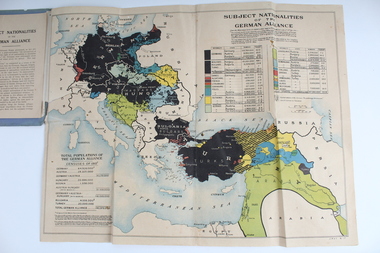
Booklet With Map, Cassell and Compnay Limited, Subject Nationalities of the German Alliance, 1917
... Grey Booklet containing Coloured map of the German Alliance...Grey Booklet Subject Nationalities of the German Alliance (With a coloured map from German Sources) Cassell and Company Limited London New York Toronto Melbourne 1917 Price 2d...Lara RSL Sub Branch McClelland Ave Lara Map Produced for Allied Forces Map of German Alliance as to which nationalities were aligned with Germany Grey Booklet Subject Nationalities of the German Alliance (With a coloured map from German Sources) Cassell and Company Limited London New York Toronto Melbourne 1917 Price 2d Grey Booklet containing Coloured map of the German Alliance Subject Nationalities of the German Alliance Booklet With Map Cassell and Compnay Limited ...Map Produced for Allied ForcesMap of German Alliance as to which nationalities were aligned with GermanyGrey Booklet containing Coloured map of the German AllianceGrey Booklet Subject Nationalities of the German Alliance (With a coloured map from German Sources) Cassell and Company Limited London New York Toronto Melbourne 1917 Price 2d -
 B-24 Liberator Memorial Restoration Australia Inc
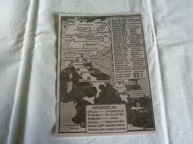
Map of Stalags in Germany, 1940s
... Map of Stalags in Germany...Map of Germany showing Stalags...B-24 Liberator Memorial Restoration Australia Inc Corner Farm Rd & Princes Highway Werribee melbourne Used in WWII a22.11 frecker Map of Germany showing Stalags Map of Stalags in Germany ...Used in WWIIMap of Germany showing Stalagsa22.11, frecker -
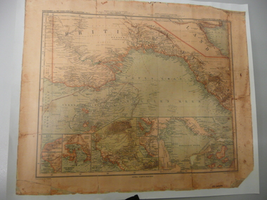 Bendigo Historical Society Inc.
Map - STRAUCH COLLECTION: MAP BRITISCH PAPUA
... This atlas was the only complete set of maps of all German Protectorates. "Gezeichnet" mean drawn by....Copy of original heritage map of ''Britisch Papua'' (N.G.) detailed & mapped by German (marine navigator) 'Gezeichnet von C.Barich & produced in the 'Langhans Deutscher Kolontal Atlas, Feb. 1893. ...This atlas was the only complete set of maps of all German Protectorates. "Gezeichnet" mean drawn by. ...This map was one of the Langhans Deutscher Kolontal Atlas produced between 1893 and 1897. This atlas was the only complete set of maps of all German Protectorates. "Gezeichnet" mean drawn by.Copy of original heritage map of ''Britisch Papua'' (N.G.) detailed & mapped by German (marine navigator) 'Gezeichnet von C.Barich & produced in the 'Langhans Deutscher Kolontal Atlas, Feb. 1893. Presented to German Society, 30.5.2008 by Mr P.Thwaites, Plans & Projects Officer (Digo 2008) Plus Society's laminated work copy of same map.map, papua -
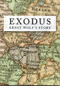 Tatura Irrigation & Wartime Camps Museum
Book, Exodus. Ernst Wolf's story, 2012
... Soft cover with a map of Germany superimposed on cover. Map of Victoria superimposed on back cover....Soft cover with a map of Germany superimposed on cover. Map of Victoria superimposed on back cover. ...Author Ernst Wolf was an internee who arrived in Australia aboard the Dunera. 68 pages, B&W and colour photos. Soft cover with a map of Germany superimposed on cover. Map of Victoria superimposed on back cover.Celebrating the 90th birthday of Ernst Wolfe, December 30th, 2011, and for the Wolfe family everywheredunera, ernst wolf, exodus -
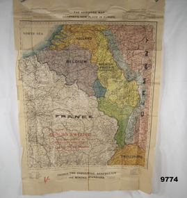 Bendigo Military Museum
Map - ARMISTICE MAP, WW1, The Industrial Australian and Mining Standard, Melbourne and Sydney>, Post June 1919
... At the top, "The Armistice map, Germany's new place in Europe"...Bendigo Military Museum 37 - 39 Pall Mall Bendigo goldfields The different colours cover France, Belgium, Luxembourg, Alsace, Lorraine, The Rhine, Nuetral zone, Germany, Switzerland, Holland, Rhenish Prussia (Germany) Item in the collection relating to C.J.C. McQuie MM, refer Cat No 9680P for his service details. maps europe armistice mcquie At the top, "The Armistice map, Germany's new place in Europe" Map in colour showing a large section of Europe, the boundaries set up after the Armistice in 1919, countries are in different colours. ...The different colours cover France, Belgium, Luxembourg, Alsace, Lorraine, The Rhine, Nuetral zone, Germany, Switzerland, Holland, Rhenish Prussia (Germany) Item in the collection relating to C.J.C. McQuie MM, refer Cat No 9680P for his service details.Map in colour showing a large section of Europe, the boundaries set up after the Armistice in 1919, countries are in different colours.At the top, "The Armistice map, Germany's new place in Europe"maps, europe, armistice, mcquie -
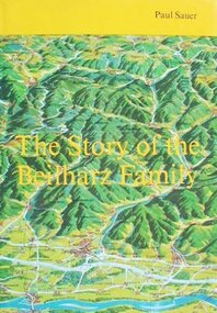 Tatura Irrigation & Wartime Camps Museum
Book, The Story of the Beilharz Family, 1988
... Yellow dust cover with map of Germany on the front cover and Palestine on the back cover...Yellow dust cover with map of Germany on the front cover and Palestine on the back cover The Story of the Beilharz Family Book ...The story of a family of Black Forest farmers and trades people, from the 15th to the 20th Century in Germany, Palestine and AustraliaBeige hard cover book. Gold text front cover and along the spine. Yellow dust cover with map of Germany on the front cover and Palestine on the back coverPresented to this Museum by Mr. HW Beilharz, Bellvue Hill, NSW 1989beilharz, sauer p, camp 3, tatura, ww2 camp 3, books, history, local -
 Whitehorse Historical Society Inc.
Map, Area map of France trench map, 03/02/1918
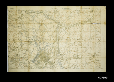
... WW1 Allied map of German trenches...Whitehorse Historical Society Inc. 2-10 Deep Creek Road Mitcham melbourne WW1 Allied map of German trenches WW1 France Trench Placements Maps World War 1914 - 1918 Coloured trench map of part of France Sheet 62B S.W. ...Coloured trench map of part of France Sheet 62B S.W. Scale 1 : 20,000non-fictionColoured trench map of part of France Sheet 62B S.W. Scale 1 : 20,000maps, world war 1914 - 1918 -
 Bendigo Military Museum
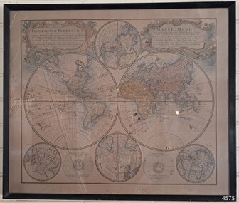
Map - MAP of NORTH AFRICA, C.1939 - 45
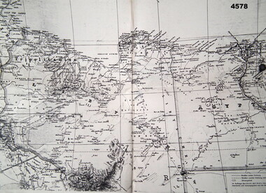
... Map, German, North Africa, 1:500 000, all print in black and in German, map covers from “Tripolis” to Pt Said”, item appears to be two sheets glued together and laminated....Bendigo Military Museum 37 - 39 Pall Mall Bendigo goldfields Doug Dean collection, refer cat No 4575P Maps german WW2 Map, German, North Africa, 1:500 000, all print in black and in German, map covers from “Tripolis” to Pt Said”, item appears to be two sheets glued together and laminated. ...Doug Dean collection, refer cat No 4575PMap, German, North Africa, 1:500 000, all print in black and in German, map covers from “Tripolis” to Pt Said”, item appears to be two sheets glued together and laminated.maps, german, ww2 -
 Bendigo Military Museum
Newspaper - NEWSPAPER EXTRACTS
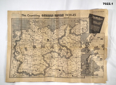
... The various map extract showed the position of the German Control of Europe at the point of time in 1944 and April 1945 near the end. ...map of the European Theatre of War dated 11 April 1945. front and Back pages covering normal news items. 2. Four page extract from "The Sun" newspaper giving a phasing of German control of Europe over period of War and a detailed map of position as at 5th August 1944. ...1. Map headed "The Crumbling German Empire 1939-45". 2. Maps headed "The War Map"....Was for general issue at a time when Allied Forces were on top moving towards German lines. WW2 Europe Maps Newspapers 1. Map headed "The Crumbling German Empire 1939-45". 2. ...The various map extract showed the position of the German Control of Europe at the point of time in 1944 and April 1945 near the end. Was for general issue at a time when Allied Forces were on top moving towards German lines.Yellow faded paper, black writing and b & W photos. 1. Four page extract from Newspaper "The Sun" with centre pages having a detailed map of the European Theatre of War dated 11 April 1945. front and Back pages covering normal news items. 2. Four page extract from "The Sun" newspaper giving a phasing of German control of Europe over period of War and a detailed map of position as at 5th August 1944. Final page lists key dates in the history of the War.1. Map headed "The Crumbling German Empire 1939-45". 2. Maps headed "The War Map".ww2, europe, maps, newspapers -
 Bendigo Historical Society Inc.
Map - STRAUCH COLLECTION: MAP EPISCOPATUS PADERBORNENSIS
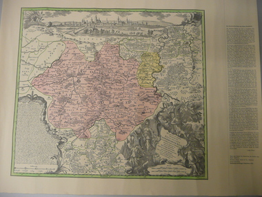
... MAP...Maps-Germany-Paderborn-German Heritage Society...Coloured map of Paderborn Germany, Presented to the German Heritage Society, Bendigo on 17.1.1995 by the most Reverend J.J.Degenhardt D.D.Archbishop of Paderborn on his visit to Bendigo with the Reverend Monsignor B.Kresing. ...History House 11 Mackenzie Street Bendigo goldfields Paderdorm is a city in the Eastern area of North Rhine-Westphalia at the source of the river Pader. MAP Maps-Germany-Paderborn-German Heritage Society Coloured map of Paderborn Germany, Presented to the German Heritage Society, Bendigo on 17.1.1995 by the most Reverend J.J.Degenhardt D.D.Archbishop of Paderborn on his visit to Bendigo with the Reverend Monsignor B.Kresing. ...Paderdorm is a city in the Eastern area of North Rhine-Westphalia at the source of the river Pader.Coloured map of Paderborn Germany, Presented to the German Heritage Society, Bendigo on 17.1.1995 by the most Reverend J.J.Degenhardt D.D.Archbishop of Paderborn on his visit to Bendigo with the Reverend Monsignor B.Kresing. Vicar-General, Paderborn and Rev. Father M.Reitemeier. (Chaplain)map, maps-germany-paderborn-german heritage society -
 Bendigo Historical Society Inc.
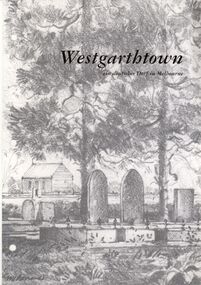
Book - STRAUCH COLLECTION: WESTGARTHTOWN
... White 3 ring binder contains information on Westgarthtown,Tatura german heritage trail with illustrations, photographs and maps, mostly written in German language....History House 11 Mackenzie Street Bendigo goldfields BHS Collection VICTORIA History german History-Victoria-German-Westgarthtown-Tatura White 3 ring binder contains information on Westgarthtown,Tatura german heritage trail with illustrations, photographs and maps, mostly written in German language. ...BHS CollectionWhite 3 ring binder contains information on Westgarthtown,Tatura german heritage trail with illustrations, photographs and maps, mostly written in German language.victoria, history, german, history-victoria-german-westgarthtown-tatura -
 Bendigo Military Museum
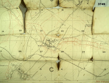
Map - TRENCH MAP, FRANCE WW1, 1917
... Trench map, France, scale 1:10,000, German trenches in red, trenches corrected to 6.4.1917, Edition 2....Map France trench Trench map, France, scale 1:10,000, German trenches in red, trenches corrected to 6.4.1917, Edition 2. ...Areas covered on this map are, “Bullecourt, Reincourt, Hendecourt”. Item relates to William Alexander No 502 AIF. Refer Cat No 3746.3 for his service details.Trench map, France, scale 1:10,000, German trenches in red, trenches corrected to 6.4.1917, Edition 2.map, france, trench -
 Tatura Irrigation & Wartime Camps Museum
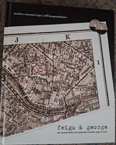
Book, Feiga & George. des vschwinden der judischen familie zajac in wien
... Hard cover book. with map of somewhere in Germany. Top left is the authors names and bottom left is the title of the book. ...Comes with two dvd of the music used in the production. feiga and george Jewish families Zajac Vienna Ralf Kaupenjohann das verschwinden der judischen familie zajac in wien Tatura camp Hay camp Hard cover book. with map of somewhere in Germany. Top left is the authors names and bottom left is the title of the book. ...a production of feiga and george, the disappearance of the Jewish family Zajac in Vienna. Comes with two dvd of the music used in the production.Hard cover book. with map of somewhere in Germany. Top left is the authors names and bottom left is the title of the book. Back cover has a black section with white writing telling what the story is aboutfeiga and george, jewish families, zajac, vienna, ralf kaupenjohann, das verschwinden der judischen familie zajac in wien, tatura camp, hay camp -
 B-24 Liberator Memorial Restoration Australia Inc
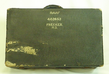
Suitcase from Mason Day Frecker, 1930s
... Suitcase contains Flying Log Book RAAF, Wedding Photo, National Archives Record Search Mason Day Frecker, Distinguished Flying Medal Register WW2 x 3, Papers on Medals and Victorian Ground Crew Numbers, Files 1 - 2 - 3 - Photographs, Leaflets, Pilots' Notes, Maps - Germany (28 maps), Buttons and badges and other medals....Suitcase contains Flying Log Book RAAF, Wedding Photo, National Archives Record Search Mason Day Frecker, Distinguished Flying Medal Register WW2 x 3, Papers on Medals and Victorian Ground Crew Numbers, Files 1 - 2 - 3 - Photographs, Leaflets, Pilots' Notes, Maps - Germany (28 maps), Buttons and badges and other medals. ...Suitcase issued to aircraft captains or crew by RAAF during World War II. The contents of M D Frecker's suitcase include World War II medals awarded to the owner, photographs, maps, pilots' handbooks, language dictionaries (Malay, Pidgin, Japanese), propaganda leaflets dropped by Japanese.Has historical and social significance, also research significance. Provenance known, owner piloted B-24 Liberator bombers and General Blamey's personal aircraft; item was donated by son. Great interpretive potential.Worn dark suitcase belonging to Mason Day Frekker, strong cardboard covered with 'leatherette', metal fasteners on front, with carry handle. Suitcase contains Flying Log Book RAAF, Wedding Photo, National Archives Record Search Mason Day Frecker, Distinguished Flying Medal Register WW2 x 3, Papers on Medals and Victorian Ground Crew Numbers, Files 1 - 2 - 3 - Photographs, Leaflets, Pilots' Notes, Maps - Germany (28 maps), Buttons and badges and other medals."RAAF/402653/Frecker/M.D." on top surface, "M.D.F." on front surface under handle.b24 liberator bomber, world war ii, raaf pilot, world war ii aerial photographs, a22.00 -
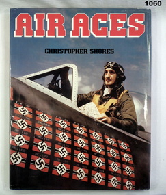 Bendigo Military Museum
Book, Air Aces
... Dust cover with pilot in cockpit holding map with 28 symbols of German aircraft shot down on side of plane. ...Dust cover with pilot in cockpit holding map with 28 symbols of German aircraft shot down on side of plane. ...Hard cover. blue, and author in silver letters on spine. Dust cover with pilot in cockpit holding map with 28 symbols of German aircraft shot down on side of plane. Pages 192 - illustrated colour and black and white.Sister M SEAGRAVE on fly leafbooks-military-history, air force -
 Flagstaff Hill Maritime Museum and Village
Map - World Map, Mappe Monde [Medieval Map of the World], 1910
... This map from the mid-18th century doesn't include the finer details of land and sea masses that we know today. The map was produced by German cartographer and publisher, Johann Baptist Homann (1663-1724) and published in 1746, after his death. ...Flagstaff Hill Maritime Museum and Village 89 Merri Street Warrnambool great-ocean-road This map from the mid-18th century doesn't include the finer details of land and sea masses that we know today. The map was produced by German cartographer and publisher, Johann Baptist Homann (1663-1724) and published in 1746, after his death. ...This map from the mid-18th century doesn't include the finer details of land and sea masses that we know today. The map was produced by German cartographer and publisher, Johann Baptist Homann (1663-1724) and published in 1746, after his death. Earlier versions were published, such as 1707 and 1716. The date can be calculated from the Roman numerals on the top left text area. This print of a map is significant for its connection with early world explorers. A comparison of maps over the centuries shows the progression of navigational technology, the countries who claimed the land they explored. The naming of even some Australian locations shows who had already made their mark on Australia in the early 18th century. The print shows the fine details included by the cartographer and the beauty included that makes it attractive and interesting even today. The map is also significant for its connection with German cartographer, Johann Baptist Homann, whose Homann publishing company was renewed in Germany for producing high quality maps and atlases. Map behind glass in dark brown wooden frame on beige paper. The Coloured hand drawn line drawings show different hemispheres of the known world in the mid-18th century. Beautifully drawn figures and decorative embellishments enhance the map. The text on the top right has an explanation of the Figures I, II, III, and IV. This print of the 1746 map was produced in England by Leisure Arts Ltd. "PLANIGLOBIL TERRESTRIS" "MDCCXXXXVI" [1746] "MAPPE_MONDE" [Medieval Map of the World] "LEISURE ARTS LTD" "Printed in England"flagstaff hill, warrnambool, flagstaff hill maritime museum, flagstaff hill maritime village, flagstaff hill maritime museum and village, shipwreck coast, world map, french map, 18th century map, leisure arts ltd, cartography, early exploration, cartographer, johann homann (1663-1724), exploration, naviagtion, 1746 planiglobil terrestris -
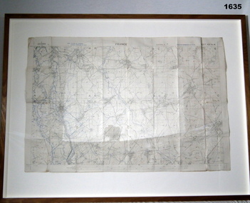 Bendigo Military Museum
Map - TRENCH MAP, FRANCE WW1, FRAMED
... Hanging wire attached at back with centre strengthening brace. Map stuck on white background. German trenches in blue. ...Hanging wire attached at back with centre strengthening brace. Map stuck on white background. German trenches in blue. Map TRENCH MAP, FRANCE WW1, FRAMED The Union Studio The Union Studio ...Belonged to JOHN WILLIAM GRINTON No 1043 C Coy 38th Batt AIF. Refer Reg No 1280 for Service Details also 1317P, 1319P. Refer 1634P for the story on the map.Trench map of France - Edition 5A Bellicourt - Montbrahain - Bran Court. Tan, wooden frame, glass front with white cardboard backing. Hanging wire attached at back with centre strengthening brace. Map stuck on white background. German trenches in blue. Top middle: France. RHS bottom rear: The Union Studio - Castlemaine sticker.documents - maps, frame accessories, military history - army -
 Dutch Australian Heritage Centre Victoria
Road Map, Nederland
... Cleverly folded 1:250,000 road map produced in Dutch, French, German and English containing not only the Dutch road network but also much information of interest to tourists. ...Map. Netherlands. Repeated in Dutch, French and German....Map. Netherlands. Repeated in Dutch, French and German. Cleverly folded 1:250,000 road map produced in Dutch, French, German and English containing not only the Dutch road network but also much information of interest to tourists. ...Cleverly folded 1:250,000 road map produced in Dutch, French, German and English containing not only the Dutch road network but also much information of interest to tourists. It is enclosed in a brown imitation leather cover that closes with a stud. Optimal ease of use through patented Falk folding mode.Falk Plan. Road Map. Netherlands. Repeated in Dutch, French and German. -
 Tatura Irrigation & Wartime Camps Museum
Folder, Camp 13 Murchison. Archival material, 1991
... Wolf. Both in German. Map 13 B. the 21 September 1942 disturbance in D compound; report in German Sydney-Kormoran; weekly rations; dimensions of a tunnel 15 June 1942. ...Wolf. Both in German. Map 13 B. the 21 September 1942 disturbance in D compound; report in German Sydney-Kormoran; weekly rations; dimensions of a tunnel 15 June 1942. ...A large collection of events in regard to Camp 13. Documents include the names of 983 German POW's in Murchison August 1941 - January 1947. An interesting collection confiscated intelligence report. No 94 included 26 gall of wine, 9 drums of fruit in an advances state of fermentation, flex copper wire, clothing, petrol motor and miscellaneous cameras and wireless parts. A letter by the German Naval Commander to all families of the Kormoran crew. History of German POW's in WW2 by H. Wolf. Both in German. Map 13 B. the 21 September 1942 disturbance in D compound; report in German Sydney-Kormoran; weekly rations; dimensions of a tunnel 15 June 1942. Drawings by Heinz Dohmen - Arandora Star; royal Oak both sunk by u boat ace Gunther Prien, Collins gunner Kloppe; Kormoran at the memorial service for HMAS Sydney; Red Cross reports in German as are letters; Rudi Pruckners escape; the general conditions and the recently found tunnel.Foolscap size folder with pillar box red 3 cm wide flap which extends to the back. On the front red flap is the inscription below. Prominent centre left is Australia with gum trees and sentry box and anti clockwise POW 1941-194. A kangaroo and emu on the top right hand corner. Prison of war and beneath Murchison - Australian.Camp 13 Murchison. Archival material.gustav pohlig, camp 13, murchison victoria, hmas sydney, hsk kormoran, heinze dohman, rudi pruckner -
 Warrnambool and District Historical Society Inc.
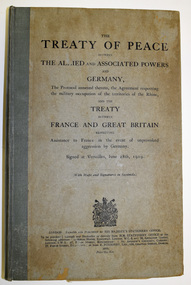
Book, The Treaty of Peace, 1919
... Germany and the Treaty between France and Great Britain. The Treaties were signed at Versailles in France on June 28th, 1919. The signatories included William Hughes, the Prime Minister of Australia and Joseph Cook, Australian Minister for the Navy. . This book has significant antiquarian value as a record of a signal event in 20th Century world history. The maps ...A record of the Treaty of VersaillesThis is a book of 451 pages. It has a grey cover with black printing on the front and a grey baize cloth binding. The binding has a tear in the spine section. The pages contain printed text in French and English and five maps inserted into a folder at the back.non-fictionA record of the Treaty of Versaillesworld war one, treaty of versailles -
 Bendigo Military Museum
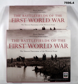
Book - BOOK, WW1, PICTORIAL, Peter BARTON, "THE BATTLEFIELDS OF THE FIRST WORLD WAR", 2005
... German prisoners and wounded Canadians crossing the battlefield, Passchendaele 1917". Back cover - "Canadian soldiers carrying trench mats. Passchendaele". 376 pages, cut plain, white paper. Illustrated black and white, sepia and colour photographs, maps...German prisoners and wounded Canadians crossing the battlefield, Passchendaele 1917". Back cover - "Canadian soldiers carrying trench mats. Passchendaele". 376 pages, cut plain, white paper. Illustrated black and white, sepia and colour photographs, maps ...From front cover- "THE BATTLEFIELDS OF THE FIRST WORLD WAR". "The Unseen Panoramas of the Western front".Box with hard cover book, dust cover and two CD's. 1. Cover - cardboard, with adhered buckram, red colour, white print on spine. Dust cover - paper, with red, black and white print, front, spine and back. Illustrated, black and white photographs. Front cover - "German prisoners and wounded Canadians crossing the battlefield, Passchendaele 1917". Back cover - "Canadian soldiers carrying trench mats. Passchendaele". 376 pages, cut plain, white paper. Illustrated black and white, sepia and colour photographs, maps and diagrams. 2. Box for book - Cardboard, duplicate of print and photographs as per dust cover. Box is open one end. 3. & 4. CD's. - two, plastic CD's in clear plastic storage envelopes adhered to back and paper cardboard cover.books, ww1, pictorial -
 Bendigo Military Museum
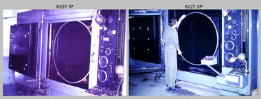
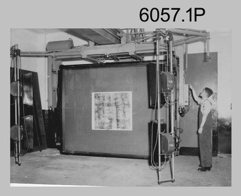
Photograph - Photographic Technicians operating the KLIMSCH Camera at the Army Survey Regiment, Fortuna, Bendigo, c1988
... Its variomat lens system provided improved retention of map feature linear weights during the camera reduction process. The camera which was specially made for the Army in Germany was fully automatic and power operated. ...Its variomat lens system provided improved retention of map feature linear weights during the camera reduction process. The camera which was specially made for the Army in Germany was fully automatic and power operated. ...These nine photographs were most likely taken in c1988 in Lithographic Squadron at the Army Survey Regiment, Fortuna, Bendigo. The equipment operated by the technicians is the KLIMCH camera. The main tasks undertaken by the technicians were most likely enlargements and reductions of map reproduction material. The KLIMSCH Commodore camera was introduced in 1953 and was the largest in the Southern Hemisphere. It was replaced with a new model of the same size in 1979. The new model with its computer-based interface provided productivity gains with improved speed and its consistent results led to less wastage in time and materials. Its variomat lens system provided improved retention of map feature linear weights during the camera reduction process. The camera which was specially made for the Army in Germany was fully automatic and power operated. It was claimed to be one of the biggest automatic cameras of its type in the world. It was made to the specifications of the Royal Australian Army Survey Corps to assist in the production of the very high standard maps for the Army. There are several more photos catalogued in the Victorian Collections database of RA Svy personnel operating the KLIMSCH camera.This is a set of four photographs of technicians operating the KLIMSCH Camera at the Army Headquarters Survey Regiment, Bendigo c1988. The photographs are on 35mm colour slides scanned at 96 dpi. They are part of the Army Survey Regiment’s Collection. .1) - Photo, colour, c1988, KLIMSCH Camera. .2) - Photo, colour, c1988, KLIMSCH Camera, unidentified technician. .3) - Photo, colour, c1988, KLIMSCH Camera. .4) - Photo, colour, c1988, KLIMSCH Camera, L to R: SPR Shona Hastie, CPL Paul Baker. .5) - Photo, colour, c1988, KLIMSCH Camera. .6) & .7) - Photo, colour, c1988, KLIMSCH Camera, SPR Shona Hastie. .8) & .9) - Photo, colour, c1988, KLIMSCH Camera, SPR Russell Pajank.35mm colour slides are in good condition.rasvy, royal australian survey corps, army survey regiment, army svy regt, fortuna, asr, litho sqn -
 Bendigo Military Museum
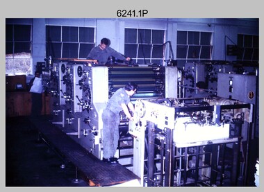
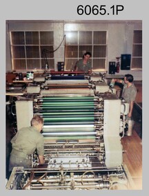
Photograph - Print Troop Equipment and Personnel, Lithographic Squadron – Army Survey Regiment, Fortuna, Bendigo, c1970s to 1980s
... The two Ultra-MAN-III Printing Presses were made in Germany at a standard map size format and introduced in June 1962 as a two-colour offset press with improved safety features. ...The two Ultra-MAN-III Printing Presses were made in Germany at a standard map size format and introduced in June 1962 as a two-colour offset press with improved safety features. ...This collection of nine photos was most likely taken in Lithographic Squadron, Army Survey Regiment, Fortuna, Bendigo, c1970s to 1980s. The two Ultra-MAN-III Printing Presses were made in Germany at a standard map size format and introduced in June 1962 as a two-colour offset press with improved safety features. With an upgrade to a third colour deck in 1968, productivity greatly improved as the two presses could print a five-colour standard topographic map in two passes, rather than the three passes before their upgrade. They were replaced with a single Heidelberg Speedmaster 102 five colour Printing Press in 1990. There is more information on the Ultra-MAN-III, Printing Press on page 71 of Valerie Lovejoy’s book 'Mapmakers of Fortuna – A history of the Army Survey Regiment’ ISBN: 0-646-42120-4. For additional photos, refer to item 6065.10P for Ultra-MAN-III presses. The Krause Wohlenberg in photo .5P was a heavy-duty guillotine to trim bulk printed map stock in the c1970s and c1980s. See item 6069.6P for more information and photos of guillotine equipment. Densitometer readings as shown in photo .6P were essential to the quality control of film and printing processes, reductions in time taken and material wastage.This is a set of nine photographs of Print Troop personnel and equipment from Lithographic Squadron at the Army Survey Regiment, Fortuna, Bendigo, c1970s to 1980s. The photographs are on 35mm colour slides and were scanned at 96 dpi. They are part of the Army Survey Regiment’s Collection. .1) - Photo, colour, c1970s, Ultra-MAN-III Printing Presses, L to R: unidentified technician, Laurie Sutton, SGT Jim Cook, unidentified technician. .2) - Photo, colour, c1970s, Ultra-MAN-III Printing Presses, unidentified technicians (x2). George Mann Fast Five Quad Demi Printing Press in background. .3) - Photo, colour, c1970s, Ultra-MAN-III Printing Presses, unidentified technicians (x2), George Austen in background and George Mann Fast Five Quad Demi Printing Press next to back wall. .4) - Photo, colour, c1970s, Ultra-MAN-III Printing Press, unidentified technicians (x2) operating George Mann Fast Five Quad Demi Printing Press in background. .5) - Photo, colour, c1970s, Krause Wohlenberg heavy-duty paper guillotine, unidentified technician. .6) - Photo, colour, c1970s, Densitometer reading taken by unidentified technician. .7) - Photo, colour, c1980s, Ultra-MAN-III Printing Presses, L to R: Janet Murray, Lance Strudwick, Terry Winzar, Komori Newkoni and Planeta Polygraph Printing Press in background. .8) to .9) - Photo, colour, c1980s, Ultra-MAN-III Printing Presses, Janet Murray, Komori Newkoni and Planeta Polygraph Printing Presses in background..1P to .9P - There are no annotations stored with the 35mm slides.royal australian survey corps, rasvy, army survey regiment, army svy regt, fortuna, asr, printing, litho -
 Bendigo Military Museum
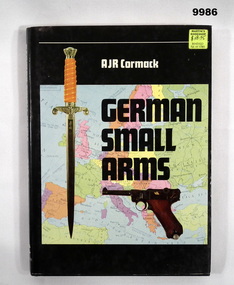
Book - MILITARY, WEAPONS, A. J. R. Cormack, "German Small Arms", 1979
... Illustrated - Front - in colour, sword and handgun superimposed on a map of Europe. Back - three black and white photographs of German Soldiers with weapons. 159 pages - cut, plain, white colour paper. ...Bendigo Military Museum 37 - 39 Pall Mall Bendigo goldfields Publication Book Military History Weapons German Hardcover book with dust cover; Hardcover - cardboard with black colour buckram. gold colour print on spine. Dust cover - paper, white and black print on front and spine. Illustrated - Front - in colour, sword and handgun superimposed on a map ...Hardcover book with dust cover; Hardcover - cardboard with black colour buckram. gold colour print on spine. Dust cover - paper, white and black print on front and spine. Illustrated - Front - in colour, sword and handgun superimposed on a map of Europe. Back - three black and white photographs of German Soldiers with weapons. 159 pages - cut, plain, white colour paper. Illustrated in colour, black and white photographs of weapons.publication, book, military history, weapons, german -
 Bendigo Military Museum
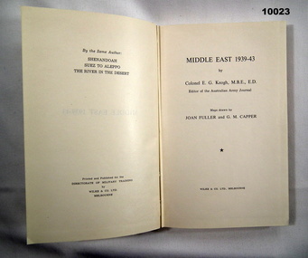
Book - MILITARY TRAINING, E.G. Keogh et al, "MIDDLE EAST 1939-43", 1958
... Also coloured maps with "British dispositions and movements are shown in blue, German and Italian red....Also coloured maps with "British dispositions and movements are shown in blue, German and Italian red. ...Hardcover Book. Cover - cardboard with light khaki colour buckram. Black colour print on spine. 303 pages - cut, plain, white paper. Illustrated black and white photographs and maps. Also coloured maps with "British dispositions and movements are shown in blue, German and Italian red.publications, books, military history, training -
 Bendigo Military Museum
Photograph - Photographic Technicians performing tasks at the Army Headquarters Survey Regiment, c1960s
... He removes the lens cap from the 70 inch F16 lens of the giant KLIMSCH camera used in map making for the Army. The camera which was specially made for the Army in Germany is fully automatic and power operated. ...He removes the lens cap from the 70 inch F16 lens of the giant KLIMSCH camera used in map making for the Army. The camera which was specially made for the Army in Germany is fully automatic and power operated. ...These eight photographs were most likely taken in the 1960s in Lithographic Squadron at the Army Headquarters Survey Regiment, Fortuna, Bendigo. Although Photo .1P is not annotated the remainder have the name of the technicians written on the back. The equipment operated by the technicians is the KLIMCH Commodore camera. The main tasks undertaken by the technicians were most likely enlargements and reductions of map reproduction material. The KLIMSCH Commodore camera was introduced in 1953 and was the largest in the Southern Hemisphere. It was replaced with a new model of the same size in 1979. The new model with its computer-based interface provided productivity gains with improved speed and its consistent results led to less wastage in time and materials. Its variomat lens system provided improved retention of map feature linear weights during the camera reduction process. The typed description pasted on the back of photo .5P states “Cpl R. MacKenzie of Bentley, Perth (WA) of the AHQ Survey Regt, located at “Fortuna”, Bendigo, (Vic). Has been in the Army for 5 years. He removes the lens cap from the 70 inch F16 lens of the giant KLIMSCH camera used in map making for the Army. The camera which was specially made for the Army in Germany is fully automatic and power operated. It is claimed to be one of the biggest automatic cameras of its type in the world. It was made to the specifications of the Aust Army Survey Corps to assist in the production of the very high standard maps for the Army. The AHQ Survey Regt also assists Commonwealth and other Govt departments in the printing of maps required other than for Army needs. The KLIMSCH camera is used for cartographic mapping photography.” This is a set of photographs of technicians operating photographic reproduction equipment at the Army Headquarters Survey Regiment, Bendigo c1960s. The photographs were printed on photographic paper and are part of the Army Survey Regiment’s Collection. The photographs were scanned at 300 dpi. .1) - Photo, black & white, c1960s, Les ‘Snow’ Taylor, Lithographic Squadron .2) - Photo, black & white, c1960s, Les ‘Snow’ Taylor, Lithographic Squadron .3) - Photo, black & white, c1960s, John Rolfe, Lithographic Squadron .4) - Photo, black & white, c1960s, John Rolfe, Lithographic Squadron .5) - Photo, black & white, c1960s, CPL R. MacKenzie, Lithographic Squadron .6) - Photo, black & white, c1960s, unidentified, Lithographic Squadron .7) - Photo, black & white, c1960s, George Graham, Lithographic Squadron .8) - Photo, black & white, c1960s, L to R: Bill Snelson, George Graham, Lithographic Squadron.1P – no annotation .2 to .4 – personnel names (less rank) annotated on back. .5 – name and rank annotated on back, with detailed typed description .6 to .8 – personnel names (less rank) annotated on back. royal australian survey corps, rasvy, army survey regiment, army svy regt, fortuna, asr, litho -
 Bendigo Military Museum
Photograph - Ultra-MAN-III Printing Presses operating at the Army Survey Regiment, c1970s to c1980s
... The two Ultra-MAN-III Printing Presses were made in Germany at a standard map size format and introduced in June 1962 as a two-colour offset press with improved safety features. ...The two Ultra-MAN-III Printing Presses were made in Germany at a standard map size format and introduced in June 1962 as a two-colour offset press with improved safety features. ...These ten photographs of the Ultra-MAN-III Printing Presses were probably taken circa 1970s to 1980s in Lithographic Squadron at the Army Survey Regiment, Fortuna, Bendigo. Although most photos are not annotated except for photos .1, .3P, .6P; most personnel are positively identified. The two Ultra-MAN-III Printing Presses were made in Germany at a standard map size format and introduced in June 1962 as a two-colour offset press with improved safety features. With an upgrade to a third colour deck in 1968, productivity greatly improved as the two presses could print a five colour standard topographic map in two passes, rather than the three passes before their upgrade. They were replaced with a single Heidelberg Speedmaster 102 five colour Printing Press in 1990. c1970s to c1980s.This is a set of photographs of the Ultra-MAN-III Printing Press operational at the Army Survey Regiment, Bendigo c1970s to c1980s. The photographs were printed on photographic paper and are part of the Army Survey Regiment’s Collection. The photographs were scanned at 300 dpi. .1) - Photo, colour, c1970s, L to R: Morgan, Mulqueen, Cook, Lithographic Squadron .2) - Photo, black & white, c1980s, unidentified, Lithographic Squadron .3) - Photo, black & white, c1980s, Ken Slater, Lithographic Squadron .4) - Photo, black & white, c1980s, L to R: Kim Reynolds, Terry Winzar, Lithographic Squadron .5) - Photo, black & white, c1980s, Lithographic Squadron .6) - Photo, black & white, c1980s, L to R: Steve Egan, unidentified, Jim Cook, Lithographic Squadron .7) - Photo, black & white, c1980s, Kim Reynolds, Lithographic Squadron .8) - Photo, black & white, c1980s, Roy Hicks, Lithographic Squadron .9) - Photo, black & white, c1980s, Lithographic Squadron .10) - Photo, black & white, c1980s, Colin Yeats, Lithographic Squadron.1, .3P, .6P – personnel annotated 2P, .4P to .5P, .76P to .10P – no annotation royal australian survey corps, rasvy, army survey regiment, army svy regt, fortuna, asr, printing, litho -
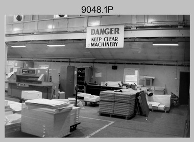 Bendigo Military Museum
Photograph - Despatch Area of Print Room, Army Survey Regiment, Fortuna, Bendigo, c1985
... map stock. See item 6242.25P for photos of the configuration. See Item 6069.6P for more information and photos of earlier types of guillotine equipment and Item 6070.9P for photos of Printer Technicians working in the despatch area of the Print Room. The two Ultra-MAN-III Printing Presses seen in photos .4P to .7P were made in Germany...map stock. See item 6242.25P for photos of the configuration. See Item 6069.6P for more information and photos of earlier types of guillotine equipment and Item 6070.9P for photos of Printer Technicians working in the despatch area of the Print Room. The two Ultra-MAN-III Printing Presses seen in photos .4P to .7P were made in Germany ...These 10 photographs of the despatch area of Lithographic Squadron’s Print Room were taken at the Army Survey Regiment, Fortuna, Bendigo circa 1985. bulk printed map stock to customers The despatch of printed map products was the final task performed by teams of Printer Technicians. It involved the wrapping of trimmed bulk maps into manageable parcels and sending them by freight to customers or to the Army Map Depot at Bandiana, VIC. The task’s Due date and sensitivity were essential considerations in the planning of production affecting the lead time and method of delivery. Freighting by commercial means was the normal method for routine tasks. The method of despatch for urgent time-critical tasks sometimes meant having to use military freight or safe-handed by Army Survey Regiment personnel. The Wohlenberg MCS-2 guillotine seen in photos .1P & .2P, .4P .8P & .9P was a heavy-duty guillotine that became in 1990 an integrated component of the Map Handling Station, to trim bulk printed map stock. See item 6242.25P for photos of the configuration. See Item 6069.6P for more information and photos of earlier types of guillotine equipment and Item 6070.9P for photos of Printer Technicians working in the despatch area of the Print Room. The two Ultra-MAN-III Printing Presses seen in photos .4P to .7P were made in Germany at a standard map size format and introduced in June 1962 as a two-colour offset press with improved safety features. With an upgrade to a third colour deck in 1968, productivity greatly improved as the two presses could print a five-colour standard topographic map in two passes, rather than the three passes before their upgrade. They were replaced with a single Heidelberg Speedmaster five colour Printing Press in 1990. The Original Heidelberg Printing Press seen in photo .6P was a single colour offset press. It was a robust and well-made lithographic printing press and was in service at the Army Svy Regt for decades. Its primary use was for initial training and rapid response tasks, such as single pass overprints over existing print stock.This is a set of 10 photographs of the despatch area of Lithographic Squadron’s Print Room, taken at the Army Survey Regiment. circa 1985, Fortuna Villa Bendigo. The photographs were printed on photographic paper and are part of the Army Survey Regiment’s Collection. The photographs were scanned at 300 dpi. .1) & .2) - Photo, black & white, c1985, Map despatch work area and Wohlenberg MCS-2 guillotine. .3) - Photo, black & white, c1985, Map despatch work area. Unidentified print technician. .4) - Photo, black & white, c1985, Map despatch work area and Wohlenberg MCS-2 guillotine. Unidentified print technician. .5) - Photo, black & white, c1985, Ultra-MAN-III Printing Presses in foreground. .6) - Photo, black & white, c1985, Original Heidelberg Printing Press in foreground, Ultra-MAN-III Printing Presses in background. .7) - Photo, black & white, c1985, Ultra-MAN-III Printing Presses in foreground. .8) - Photo, black & white, c1985, Map despatch work area. Pallets of wrapped printed maps in foreground, pallets of paper stock in background. .9) - Photo, black & white, c1985, Map despatch work area. Pallets of printed maps awaiting wrapping in foreground, Wohlenberg MCS-2 guillotine in background. .10) - Photo, black & white, c1985, Map despatch work area, pallets of wrapped printed maps in foreground, Pallets of wrapped printed maps in background..1P to .10P – There are no annotationsroyal australian survey corps, rasvy, fortuna, army survey regiment, printing, litho, litho sqn