Showing 12 items matching "maroondah county"
-
 Marysville & District Historical Society
THE TRIANGLE NEWS-VOL 4 NO 42-DECEMBER 20 1979
... ...maroondah county...Marysville & District Historical Society 39 Darwin Street Marysville yarra-valley-and-the-dandenong-ranges marysville victoria australia revue 1979 success letter to editor welders warning school & kinder photos narbethong mothers' club walpy news community care centre thanks carols by candlelight church transport wanted situation vacant swimming lessons fire brigade marysville golf club summer workshop buxton found glasses greetings brownies guides cubs & scouts swimming pool nye special crossways new owners lost watch maroondah county pumpernickel wirrianda stud for sale wanted marysville hotel nye supper dance narbethong hotel cricket wirreanda tshirts marysville hotel revue wirrianda appaloosa stallion happy hour 12 12 1979 host silo committee red cross walpeup primary school concert church wheat t.t.c. & t.c.c. cabaret fire roster donations exchange or buy donation mothers' club ladies' guild ladies' social club THE TRIANGLE NEWS-VOL 4 NO 42-DECEMBER 20 1979 ...marysville, victoria, australia, revue 1979 success, letter to editor, welders warning, school & kinder photos, narbethong mothers' club, walpy news, community care centre, thanks, carols by candlelight, church, transport wanted, situation vacant, swimming lessons, fire brigade, marysville golf club, summer workshop buxton, found glasses, greetings, brownies guides cubs & scouts, swimming pool, nye special, crossways new owners, lost watch, maroondah county, pumpernickel, wirrianda stud, for sale, wanted, marysville hotel, nye supper dance, narbethong hotel, cricket, wirreanda tshirts, marysville hotel revue, wirrianda appaloosa stallion, happy hour 12 12 1979 host, silo committee, red cross, walpeup primary school concert, church wheat, t.t.c. & t.c.c. cabaret, fire roster, donations, exchange or buy, donation mothers' club, ladies' guild, ladies' social club -
 Emerald Museum & Nobelius Heritage Park
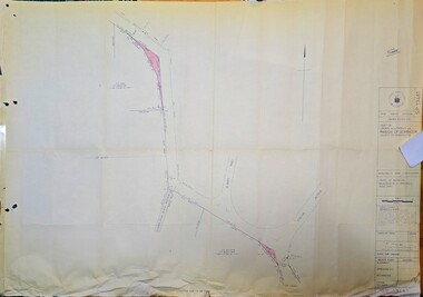
Map - Surveyors map of Wellington Rd. near Magpie Rd., Clematis, Part of Crown allotments 106E and 106G2, survey map of Wellington Rd., near Magpie Rd. 1972, c1972
... Title Survey Division/Crown Description/Part of Crown Allotments 106E and 106G2/Parish of Narree Worran, County of Mornington/Cardinia/Shire of Sherbrooke, Wellington Road/Rossley Paul Gardiner of Kirkpatrick & Webber, 289 Maroondah Hwy, Ringwood/Signed S.R. ...Emerald Museum & Nobelius Heritage Park 5 Crichton Rd Emerald yarra-valley-and-the-dandenong-ranges Title Survey Division/Crown Description/Part of Crown Allotments 106E and 106G2/Parish of Narree Worran, County of Mornington/Cardinia/Shire of Sherbrooke, Wellington Road/Rossley Paul Gardiner of Kirkpatrick & Webber, 289 Maroondah Hwy, Ringwood/Signed S.R. ...Image of Surveyors map outlining part of Wellington Rd., Near Magpie Rd., Clematis 1972Title Survey Division/Crown Description/Part of Crown Allotments 106E and 106G2/Parish of Narree Worran, County of Mornington/Cardinia/Shire of Sherbrooke, Wellington Road/Rossley Paul Gardiner of Kirkpatrick & Webber, 289 Maroondah Hwy, Ringwood/Signed S.R. Clarke 21.6.72/B.A. Gibson C/T 8047/414 subtract 0.01 1/2 for Title -
 Emerald Museum & Nobelius Heritage Park
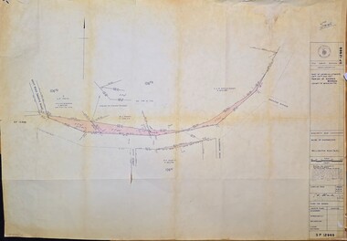
Map - Surveyors map of Wellington Rd. near Magpie Rd., and Paradise Rd., Clematis, Part of Crown allotments 106E and 106G2, survey map of Wellington Rd., near Magpie Rd. and Paradise Rd., Clematis 1972, c1972
... Title Survey Division/Crown Description/Part of Crown Allotments 106F2 and 106G1/Parish of Narree Worran, County of Mornington/Cardinia/Shire of Sherbrooke, Wellington Road/Rossley Paul Gardiner of Kirkpatrick & Webber, 289 Maroondah Hwy, Ringwood/Signed S.R. ...Emerald Museum & Nobelius Heritage Park 5 Crichton Rd Emerald yarra-valley-and-the-dandenong-ranges Title Survey Division/Crown Description/Part of Crown Allotments 106F2 and 106G1/Parish of Narree Worran, County of Mornington/Cardinia/Shire of Sherbrooke, Wellington Road/Rossley Paul Gardiner of Kirkpatrick & Webber, 289 Maroondah Hwy, Ringwood/Signed S.R. ...Image of Surveyors map outlining part of Wellington Rd., Near Magpie Rd. and Paradise Rd., Clematis 1972Title Survey Division/Crown Description/Part of Crown Allotments 106F2 and 106G1/Parish of Narree Worran, County of Mornington/Cardinia/Shire of Sherbrooke, Wellington Road/Rossley Paul Gardiner of Kirkpatrick & Webber, 289 Maroondah Hwy, Ringwood/Signed S.R. Clarke 21.6.72 -
 Emerald Museum & Nobelius Heritage Park
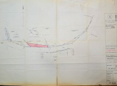
Map - Surveyors map of Wellington Rd. near Magpie Rd., and Paradise Rd., Clematis, Part of Crown allotments 106F2 and 106G1, survey map of Wellington Rd., near Magpie Rd. and Paradise Rd., Clematis 1972, c1972
... Title Survey Division/Crown Description/Part of Crown Allotments 106F2 and 106G1/Parish of Narree Worran, County of Mornington/Cardinia/Shire of Sherbrooke, Wellington Road/Rossley Paul Gardiner of Kirkpatrick & Webber, 289 Maroondah Hwy, Ringwood/Signed S.R. ...Emerald Museum & Nobelius Heritage Park 5 Crichton Rd Emerald yarra-valley-and-the-dandenong-ranges Title Survey Division/Crown Description/Part of Crown Allotments 106F2 and 106G1/Parish of Narree Worran, County of Mornington/Cardinia/Shire of Sherbrooke, Wellington Road/Rossley Paul Gardiner of Kirkpatrick & Webber, 289 Maroondah Hwy, Ringwood/Signed S.R. ...Image of Surveyors map outlining part of Wellington Rd., Near Magpie Rd. and Paradise Rd., Clematis 1972Title Survey Division/Crown Description/Part of Crown Allotments 106F2 and 106G1/Parish of Narree Worran, County of Mornington/Cardinia/Shire of Sherbrooke, Wellington Road/Rossley Paul Gardiner of Kirkpatrick & Webber, 289 Maroondah Hwy, Ringwood/Signed S.R. Clarke 21.6.72 -
 Emerald Museum & Nobelius Heritage Park
Map - Municipality Road Classification - Beaconsfield-Emerald Rd., Shire of Gembrook 1973, Title Survey Division, Crown Description - Part of Crown Allotment 44, Parish of Gembrook, County of Mornington, c1973
... Title Survey Division/Crown Description/Part of Crown Allotment 44, Parish of Gembrook, County of Mornington/Municipality Road Classification, Shire of Berwick, Beaconsfeld-Emerald Rd. (MR)/Francis J Webber of Kirkpatrick & Webber, 285 Maroondah Hwy., Ringwood/(Signed) - Principal Title Survey Office 16.1.73/SP13461...Emerald Museum & Nobelius Heritage Park 5 Crichton Rd Emerald yarra-valley-and-the-dandenong-ranges Title Survey Division/Crown Description/Part of Crown Allotment 44, Parish of Gembrook, County of Mornington/Municipality Road Classification, Shire of Berwick, Beaconsfeld-Emerald Rd. (MR)/Francis J Webber of Kirkpatrick & Webber, 285 Maroondah Hwy., Ringwood/(Signed) - Principal Title Survey Office 16.1.73/SP13461 Image of Crown Survey Map for crown allotment 44 (Beaconsfield-Emerald Rd.) parish of Gembrook, County of Mornington Title Survey Division, Crown Description - Part of Crown Allotment 44, Parish of Gembrook, County of Mornington Map Municipality Road Classification - Beaconsfield-Emerald Rd., Shire of Gembrook 1973 ...Image of Crown Survey Map for crown allotment 44 (Beaconsfield-Emerald Rd.) parish of Gembrook, County of MorningtonTitle Survey Division/Crown Description/Part of Crown Allotment 44, Parish of Gembrook, County of Mornington/Municipality Road Classification, Shire of Berwick, Beaconsfeld-Emerald Rd. (MR)/Francis J Webber of Kirkpatrick & Webber, 285 Maroondah Hwy., Ringwood/(Signed) - Principal Title Survey Office 16.1.73/SP13461 -
Emerald Museum & Nobelius Heritage Park
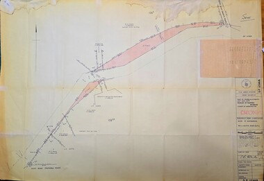
Map - Municipality Road Classification - Wellington Rd. (part) - Near Kitty Street, Crown Survey map - Crown allotments 106F2 & 106 G1 - Wellington Rd. near Kitty Street, c1972
... SP12969/Title Survey Division/Crown Description/Part of Crown Alloments 106F2, 106F3 and 106G1, Parish of Narree Worran, County of Mornington/Municipality Road Classification/Shire of Sherbrooke, Wellington Road/(signed) Rossley Paul Gardner of Kirkpatrick & Webber, 280 Maroondah Highway, Ringwood, 29th March 1972/(Signed) S.R. ...Emerald Museum & Nobelius Heritage Park 5 Crichton Rd Emerald yarra-valley-and-the-dandenong-ranges SP12969/Title Survey Division/Crown Description/Part of Crown Alloments 106F2, 106F3 and 106G1, Parish of Narree Worran, County of Mornington/Municipality Road Classification/Shire of Sherbrooke, Wellington Road/(signed) Rossley Paul Gardner of Kirkpatrick & Webber, 280 Maroondah Highway, Ringwood, 29th March 1972/(Signed) S.R. ...Image of Title survey - Part of Crown Allotments 106F2 and 106G1 - Wellington Road, Shire of Sherbrooke SP12969/Title Survey Division/Crown Description/Part of Crown Alloments 106F2, 106F3 and 106G1, Parish of Narree Worran, County of Mornington/Municipality Road Classification/Shire of Sherbrooke, Wellington Road/(signed) Rossley Paul Gardner of Kirkpatrick & Webber, 280 Maroondah Highway, Ringwood, 29th March 1972/(Signed) S.R. CLARKE, Principal Title Survey Officer & Proper Officer 21.6.72 -
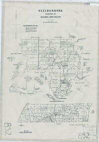 Greensborough Historical Society
Map, Keelbundora. Counties of Bourke and Evelyn, 1950_11
... Greensborough Historical Society 34A Glenauburn Road Lower Plenty Lower Plenty melbourne Covers area bounded by Merri Creek, Yarra River, Plenty River and Crown Portions 24 to 28, with section including Maroondah Aqueduct and Darebin Creek. keelbundora (parish) Photocopy of digitised map Keelbundora. Counties ...Covers area bounded by Merri Creek, Yarra River, Plenty River and Crown Portions 24 to 28, with section including Maroondah Aqueduct and Darebin Creek.Photocopy of digitised mapkeelbundora (parish) -
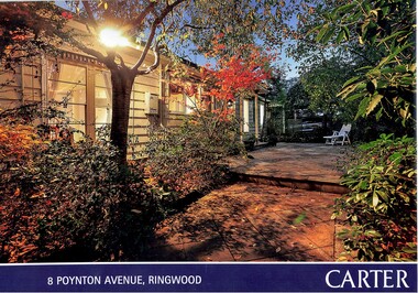 Ringwood and District Historical Society
Document, Property Auction Notice and History Notes - 8 Poynton Avenue, Ringwood, Victoria - 2015
... County of Evelyn. Geoffrey Alleyne Cook and Muriel Cook. Certificate of Title Vol 9093 Fol 503 - Lot 4 on Plan of Subdivision No. 114942 derived May 1975. Certificate of Title Vol 8932 Fol 047 - Lot 1 on Plan of Subdivision No. 94505 derived July 1972. Ethel Porter, Crown Allotment twenty-eight, Certificate of Title Vol 6599 Fol 1319603, dated January 1943. Agent - Carter.com.au 90 Maroondah...County of Evelyn. Geoffrey Alleyne Cook and Muriel Cook. Certificate of Title Vol 9093 Fol 503 - Lot 4 on Plan of Subdivision No. 114942 derived May 1975. Certificate of Title Vol 8932 Fol 047 - Lot 1 on Plan of Subdivision No. 94505 derived July 1972. Ethel Porter, Crown Allotment twenty-eight, Certificate of Title Vol 6599 Fol 1319603, dated January 1943. Agent - Carter.com.au 90 Maroondah ...A4 size window display advertisement for auction on Saturday 30th May (2015) and 3-page handwritten history notes on 8 Poynton Avenue Ringwood with photocopied LANDATA Land Victoria publication printouts Plan of Subdivision of Part of Crown Allotment 28, Parish of Warrandyte, County of Evelyn. Geoffrey Alleyne Cook and Muriel Cook. Certificate of Title Vol 9093 Fol 503 - Lot 4 on Plan of Subdivision No. 114942 derived May 1975. Certificate of Title Vol 8932 Fol 047 - Lot 1 on Plan of Subdivision No. 94505 derived July 1972. Ethel Porter, Crown Allotment twenty-eight, Certificate of Title Vol 6599 Fol 1319603, dated January 1943. Agent - Carter.com.au 90 Maroondah Hwy, Ringwood, (Tel) 9870 6211. Handwritten notation "Sold $920000 5/15". -
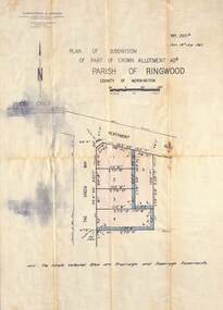 Ringwood and District Historical Society
Map - Plan of Subdivision, Part of Crown Allotment 40B, Parish of Ringwood, County of Mornington - 1965
... Maroondah Highway, Ringwood Telephone 870 0321. Map showing residential allotments numbered 1 to 5 on Heathmont Road and The Greenway, Heathmont, Victoria. Part of Crown Allotment 40B, Parish of Ringwood, County ...Map showing residential allotments numbered 1 to 5 on Heathmont Road and The Greenway, Heathmont, Victoria.Ref. 2937A Date 19 July 1965. Kirkpatrick & Webber, Licensed Surveyors, Civil Engineers & Town Planners, Maroondah Highway, Ringwood Telephone 870 0321. -
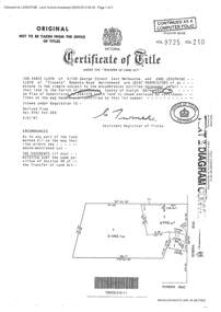 Ringwood and District Historical Society
Document - Certificate of Title and Maroondah Heritage Study, "Elouera", 59 Bemboka Road, Warranwood, Victoria, previously part of Crown Section 20, Parish of Warrandyte, County of Evelyn - 4th February, 1987
... "Elouera", 59 Bemboka Road, Warranwood, Victoria, previously part of Crown Section 20, Parish of Warrandyte, County of Evelyn - 4th February, 1987. Document Certificate of Title and Maroondah Heritage Study ...Property subsequently subdivided into residential allotments with formation of Aspen Court, Warranwood, circa 2010.A4 copies of Landata Victoria documents - Vol 9725 Fol 210 derived from Vol 9701 Vol 469, and 2-page Heritage Study report.Ian Vance Lloyd and June Josephine Lloyd are joint proprietors of an estate in fee simple - Lot 4 on Plan of Subdivision no.204137B shown on the map. Subdivision includes Bemboka Road. Encumbrance E-1 later extended through Lot 4 as Aspen Court. Transfer - Proprietor June Josephine Lloyd - 29 July, 1993. Documents include 2-page Heritage report for study conducted prior to subsequent Aspen Court residential development circa 2010. -
 Ringwood and District Historical Society
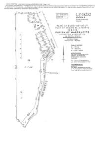
Document - Subdivision Plan, LP113220 Part of Crown Allotments 35 & 39B, Parish of Warrandyte, County of Mornington, Vol 6421 Fol 183 & 184 - 1965
... Maroondah Highway, Ringwood. Additional markings include LP86253. Both sheets include location of Drainage and Sewerage Reserve along Mullum Mullum Creek. LANDATA Land Victoria 2-sheet plan printout dated 2009 LP113220 Part of Crown Allotments 35 & 39B, Parish of Warrandyte, County of Mornington, Vol 6421 Fol 183 & 184 - 1965 Document Subdivision Plan ...LANDATA Land Victoria 2-sheet plan printout dated 2009Sheet 1 includes Kalinda Road, Ringwood. Additional markings include LP113117. Sheet 2 includes Kalinda Road and Maroondah Highway, Ringwood. Additional markings include LP86253. Both sheets include location of Drainage and Sewerage Reserve along Mullum Mullum Creek. -
 Ringwood and District Historical Society
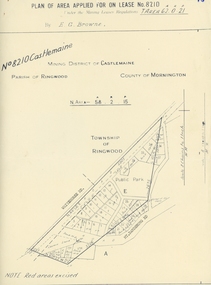
Map, Department of Mines, Plan of area applied for under the mining leases regulations in the township of Ringwood between Maroondah Highway and Mt. Dandenong Road. Mining District of Castlemaine, County of Mornington, Parish of Ringwood T Area 58(A) 2 (R)15(P) Acres, Roods, Perches. 1934, 20-Feb-34
... Plan of area applied for under the mining leases regulations in the township of Ringwood between Maroondah Highway and Mt. Dandenong Road. Mining District of Castlemaine, County of Mornington, Parish of Ringwood T Area 58(A) 2 (R)15(P) Acres, Roods, Perches. 1934...Maroondah Highway and Mt. Dandenong Road. the area applied for on lease No.8210 by E.G.Browne.Mining District of Castlemaine, County of Mornington, Parish of Ringwood T Area 58(A) 2 (R)15(P) Acres, Roods, Perches....Buff coloured sheet foolscap with black printing showing map of the township of Ringwood between Maroondah Highway and Mt. Dandenong Road. Mining District of Castlemaine, County of Mornington, Parish of Ringwood T Area 58(A) 2 (R)15(P) Acres, Roods, Perches +Additional Keywords: Browne E.G....Maroondah Highway and Mt. Dandenong Road. the area applied for on lease No.8210 by E.G.Browne.Mining District of Castlemaine, County of Mornington, Parish of Ringwood T Area 58(A) 2 (R)15(P) Acres, Roods, Perches. ...Map of the township of Ringwood with subdivisions between Maroondah Highway and Mt. Dandenong Road. the area applied for on lease No.8210 by E.G.Browne.Mining District of Castlemaine, County of Mornington, Parish of Ringwood T Area 58(A) 2 (R)15(P) Acres, Roods, Perches.Buff coloured sheet foolscap with black printing showing map of the township of Ringwood between Maroondah Highway and Mt. Dandenong Road. Mining District of Castlemaine, County of Mornington, Parish of Ringwood T Area 58(A) 2 (R)15(P) Acres, Roods, Perches +Additional Keywords: Browne E.G.