Showing 42 items matching "marshall's gully"
-
 Whitehorse Historical Society Inc.
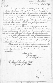
Letter - Correspondence, Roads, 10/10/1867
... Marshall's Gully...Padgham to Road Board Engineer dated 10 October 1867 re representations by Mr Cook about location of road relating to Mr Cumming's land and Marshall's Gully....Whitehorse Historical Society Inc. 2-10 Deep Creek Road Mitcham melbourne Marshall's Gully Roads and Streets Cook William Cummings (Mr) Padgham Silas Letter from S. ...Letter from S. Padgham to Road Board Engineer dated 10 October 1867 re representations by Mr Cook about location of road relating to Mr Cumming's land and Marshall's Gully.marshall's gully, roads and streets, cook, william, cummings, (mr), padgham, silas -
 Whitehorse Historical Society Inc.
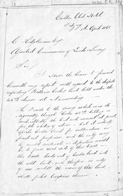
Letter - Document, Roads, 1/04/1868
... Marshall's Gully...Whitehorse Historical Society Inc. 2-10 Deep Creek Road Mitcham melbourne Marshall's Gully Cook William Cumming (Mr) Watkins William H Hodgkinson Clement Roads and Streets Letter to C. ...Letter to C. Hodgkinson, Assistant Commissioner of Lands Survey from William H. Watkins, Bailiff of Crown Lands, dated 1 April 1868 re alternative locations of road through Messrs Cook or Cummings land in Nunawading.marshall's gully, cook, william, cumming (mr), watkins, william h, hodgkinson, clement, roads and streets -
 Eltham District Historical Society Inc
Document - Folder, Motschall, Emil and Marjorie Florence Smith
... Gully Road Panton Hill...Wild Wood Days at Panton Hill...Robert Marshall...Marshall, of Marjorie Smith Motschall's book "Wild Wood Days at Panton Hill". Newspaper article: "Rare welcome for visitors to craftschop", Diamond Valley News, 20 March 1984. Small drama of locked door at Montsalvat craftschop. Newspaper article: "Marjorie Florence Smith Motschall". Obituary. Newspaper death notices: Marjorie Motschall. Emile William (Mon) Motschall Panton Hill Vic Panton Hill Fire Brigade British Empire Medal Marjorie Florence Smith Motschall Albert Motschall Arthur Cracknell Edwin Smith Violet Smith Long Gully ...Emil William (Mon) Motschall lived at Panton Hill all his life and married Marjorie Smith, also a local. In 1969, he was awarded the British Empire Medal for services to the local Fire Brigade and was involved with other local organisations. Marjorie wrote two chapters in Alan Marshall's book "Pioneers and Painters" and wrote a history of Panton Hill. Contents Newspaper article: "Mon devoted a life to the Hill", Diamond Valley News, c1977, Life of Emil Motschall. Newspaper article: "His dam nearly runneth over", Diamond Valley News, 8 July 1980, p1. Noel Motschall's Panton Hill orchard received good rain. Newspaper article: "Book on 'Hill' is launched", Diamond Valley News, 20 March 1984. Launch, by Robert Marshall, of Marjorie Smith Motschall's book "Wild Wood Days at Panton Hill". Newspaper article: "Rare welcome for visitors to craftschop", Diamond Valley News, 20 March 1984. Small drama of locked door at Montsalvat craftschop. Newspaper article: "Marjorie Florence Smith Motschall". Obituary. Newspaper death notices: Marjorie Motschall.Newspaper clippings, A4 photocopies, etcemile william (mon) motschall, panton hill vic, panton hill fire brigade, british empire medal, marjorie florence smith motschall, albert motschall, arthur cracknell, edwin smith, violet smith, long gully road panton hill, wild wood days at panton hill, robert marshall, alan marshall, "pioneers and painters", reverend peter lawry, montsalvat, evie gough, susan gough, william motschall, rosemary motschall, marjorie anne motschall, noel mitcshall -
 Eltham District Historical Society Inc
Photograph - Digital Photograph, Alan King, Panton Hill Hotel, 27 March 2008
... Marshall.; p61 Panton Hill was originally known as Kingstown, and consisted of only one hotel when the Orams Reef was discovered in 1859. Kingstown was a quartz mining centre and many old mine shafts remain in the area. Orams Reef was one of the first reefs with a rich find of gold in the area. The Hotel Francais, which had been operating in 1861, was well situated on the way to Queenstown (later St Andrews). So was Herr Hirt’s Hotel and store at Smiths Gully...Marshall.; p61 Panton Hill was originally known as Kingstown, and consisted of only one hotel when the Orams Reef was discovered in 1859. Kingstown was a quartz mining centre and many old mine shafts remain in the area. Orams Reef was one of the first reefs with a rich find of gold in the area. The Hotel Francais, which had been operating in 1861, was well situated on the way to Queenstown (later St Andrews). So was Herr Hirt’s Hotel and store at Smiths Gully ...Today’s Panton Hill Hotel was built around 1920. Published: Nillumbik Now and Then / Marguerite Marshall 2008; photographs Alan King with Marguerite Marshall.; p61 Panton Hill was originally known as Kingstown, and consisted of only one hotel when the Orams Reef was discovered in 1859. Kingstown was a quartz mining centre and many old mine shafts remain in the area. Orams Reef was one of the first reefs with a rich find of gold in the area. The Hotel Francais, which had been operating in 1861, was well situated on the way to Queenstown (later St Andrews). So was Herr Hirt’s Hotel and store at Smiths Gully. The Kingstown hotel, known as the Frenchman’s and in 1864 as the Hotel de France, was run by a Monsieur Emile Hude and his wife Jeanne, and known for its good food. They hosted social events, business conventions and debates, attracting patrons from as far as Melbourne. The hotel’s name was changed to Panton Hill Hotel in 1905. In 1883 Charles Caudwell built another hotel nearby, possibly in Long Gully Road,3 which it is thought, was burnt down early last century. Today’s Panton Hill Hotel, built around 1920, is the only one of the cluster of buildings in the main road, not to date from around the turn of last century. It was severely damaged by fire in 2003, then underwent extensive alterations. It is the township’s only hotel and is an example of a modest hotel building exterior, constructed early last century. In its early days the hotel also housed the first post office, newsagency and store. Orams Reef yielded a total of £100,000, and fossikers also found alluvial gold in the creeks and gullies, but there is no record of the total value of their finds. Gold greatly increased the Panton Hill population, which peaked between 1865 and 1885. On holidays large sports meetings were held with wood chopping contests and foot races and the day would end with a ball. Miners came from various countries to seek their fortune, including many from China. The Chinese became unpopular however, and gradually left the district, although some stayed and grew and sold vegetables.5 Panton Hill was named after Joseph Panton, who in 1862 was appointed Police Magistrate for the Woods Point, Heidelberg and Yarra districts. Panton was an outstanding man, who in 1852, was Commissioner of Crown Lands and Assistant Commissioner of Goldfields at Bendigo. In 1874 he was promoted to Chief Magistrate for the Melbourne Police. Panton was also an artist, becoming president of the Victorian Arts Society in 1888, and in 1913, president of the Royal Geographical Society. Despite Panton Hill’s prosperity, it still lacked many services as poor roads made access to Melbourne difficult. A horse-drawn mail coach travelled to Melbourne until 1890, when the railway came to Heidelberg. The nearest doctor was at Yarra Glen or Heidelberg, and the Indian hawker Singh’s annual visit was very welcome. A miner’s shack opposite the school was used as a post office. Today’s general store and post office in the main road dates from early last century, and has changed considerably. While most people searched for gold, the more enterprising ones established farms to feed the diggers. Farmers grew wheat, barley and oats, and sent animal skins to the Eltham tannery, to make furs in Melbourne. As gold became scarce from around 1880, miners took up farming on 19 to 20 acre (8ha) allotments. The first settlers in Cherry Tree Road included Purcell, Smith, Owens, Hughes and Shillinglaw. By 1900 all the land had been taken up around Panton Hill and Hurstbridge. The orchards in Panton Hill and the wider district, particularly of apple and pear, were very successful, and made Panton Hill a cohesive and successful community. About 1914 the Moores built the first cool-store and refrigeration plant at their orchard in Cherry Tree Road. Many settlers planted vineyards and made high quality wine, but in 1922 the blight destroyed them.This collection of almost 130 photos about places and people within the Shire of Nillumbik, an urban and rural municipality in Melbourne's north, contributes to an understanding of the history of the Shire. Published in 2008 immediately prior to the Black Saturday bushfires of February 7, 2009, it documents sites that were impacted, and in some cases destroyed by the fires. It includes photographs taken especially for the publication, creating a unique time capsule representing the Shire in the early 21st century. It remains the most recent comprehenesive publication devoted to the Shire's history connecting local residents to the past. nillumbik now and then (marshall-king) collection, panton hill hotel -
 Eltham District Historical Society Inc
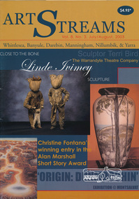
Journal, Peter Doughtery, ArtStreams: Whittlesea, Banyule, Darebin, Manningham, Nillumbik & Yarra; Vol. 8, No. 3, Jul-Aug 2003, 2003
... Gully General Store...Jenni Mitchell...Scott Henley...Marion Borgelt...Zelij moroccan interiors...st andrews hotel...City of Whittlesea heritage program...Hawkestowe Park...Bundoora Homestead...dunmoochin...il primo restaurant carlton...Hurstbridge Nursery...bulleen art & garden centre...eltham gourmet poultry & game...bahnhof cafe...manningham arts centre...manningham gallery...Arts on Burgundy...bendigo bank...Hurstbridge & Districts Community Bank Branch...Alan Marshall...." - Eltham District Historical Society Newsletter No. 161, March 2005 art streams Art masters Thompsons Amcal Pharmacy clemm christesen christine Fontana Corrina Tauschke terri bird willy wonka's ice cream gourmet food Nillumbik art in Public Places Award Eltham Wiregrass Gallery wild dog hill recording and project studio sushi wushi Eltham Fiona Sievers julian chapple Warrandyte Mechanics Institute Montsalvat Eltham Fullife pharmacy warrandyte cafe Northcote pottery Smiths Gully General Store Jenni Mitchell Scott Henley Marion Borgelt Zelij moroccan interiors st andrews hotel City of Whittlesea heritage program Hawkestowe Park Bundoora Homestead dunmoochin il primo restaurant carlton Hurstbridge Nursery bulleen art & garden centre eltham gourmet poultry & game bahnhof cafe manningham arts centre manningham gallery Arts on Burgundy bendigo bank Hurstbridge & Districts Community Bank Branch Alan Marshall Short Story Award Colour front and back cover with feature articles and literary pieces with photographs and advertisements printed in black and white. 36 pages, 30 cm. ...Vol. 8, No. 3, Jul-Aug 2003 CONTENTS Short Story by Christine Fontana 3 Corrina Taustche on Terri Bird 7 Barry Dickins on John Jenkins 10 Fiona Sievers on Jordie Albiston 11 Julian Chapple's tales from India 12 Justin Fitzpatrick on the Warrandyte Theatre 13 Sandy Jeffs' Poetry 16 Book Review - Barenboim and Said 19 CD Review by Betty Scarlett 20 Jenni Mitchell - 'To The Ice' 21 Scott Henley on Marion Borgelt Exhibition 22 'Wandering Whittlesea' 24 'Origin: Dunmoochin' at Montsalvat 25 Artin' About 26 Wining & Dining 30 "Peter Dougherty has been involved in the local art scene for many years. As publisher and editor of the arts magazine Artstreams, his comments on the various branches of the arts are widely respected. His "The Arts" column in the Diamond Valley Leader presents a brief summary for a much wider cross section of the local community. Peter also operates his own gallery and the Artstreams Cafe at the St Andrews market. Peter has a wealth of knowledge about present day and historical aspects of local art and artists." - Eltham District Historical Society Newsletter No. 161, March 2005Colour front and back cover with feature articles and literary pieces with photographs and advertisements printed in black and white. 36 pages, 30 cm. Vol. 1, no. 1 (Nov. 1996) - Vol. 10, no. 5 (summer ed. 2005/06) art streams, art masters, thompsons amcal pharmacy, clemm christesen, christine fontana, corrina tauschke, terri bird, willy wonka's ice cream gourmet food, nillumbik art in public places award, eltham wiregrass gallery, wild dog hill recording and project studio, sushi wushi eltham, fiona sievers, julian chapple, warrandyte mechanics institute, montsalvat, eltham fullife pharmacy, warrandyte cafe, northcote pottery, smiths gully general store, jenni mitchell, scott henley, marion borgelt, zelij moroccan interiors, st andrews hotel, city of whittlesea heritage program, hawkestowe park, bundoora homestead, dunmoochin, il primo restaurant carlton, hurstbridge nursery, bulleen art & garden centre, eltham gourmet poultry & game, bahnhof cafe, manningham arts centre, manningham gallery, arts on burgundy, bendigo bank, hurstbridge & districts community bank branch, alan marshall short story award -
 Eltham District Historical Society Inc
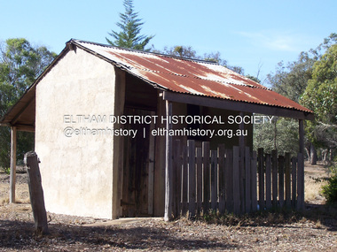
Photograph - Digital Photograph, Marguerite Marshall, Stuchbery Farm dairy, 14 March 2008
... Gully to the north and La trobe Road, Yarrambat, to the east. Alan and Ada Stutchbery moved to the valley in 1890, first living in a tent where four children were born. Alfred built a home and outbuildings around 1896. They planted an orchard, then a market garden and developed a dairy. Published: Nillumbik Now and Then / Marguerite Marshall...Gully to the north and La trobe Road, Yarrambat, to the east. Alan and Ada Stutchbery moved to the valley in 1890, first living in a tent where four children were born. Alfred built a home and outbuildings around 1896. They planted an orchard, then a market garden and developed a dairy. Published: Nillumbik Now and Then / Marguerite Marshall ...Stuchbery Farm was situated on the Plenty River bounded by Smugglers Gully to the north and La trobe Road, Yarrambat, to the east. Alan and Ada Stutchbery moved to the valley in 1890, first living in a tent where four children were born. Alfred built a home and outbuildings around 1896. They planted an orchard, then a market garden and developed a dairy. Published: Nillumbik Now and Then / Marguerite Marshall 2008; photographs Alan King with Marguerite Marshall.; p179 The dramatic steep-sided Plenty Gorge lies along the divide of two geological areas, and separates the Nillumbik Shire and the City of Whittlesea. On the Nillumbik side are undulating hills and sedimentary rock, and in Whittlesea, lies a basalt plain formed by volcanic action up to two million years ago. This provides the Plenty Gorge Park with diverse vegetation and habitats, making it one of Greater Melbourne’s most important refuges for threatened and significant species. The park, established in 1986, consists of around 1350 hectares, and extends 11 kilometres along the Plenty River, from Greensborough to Mernda. It provides a wildlife corridor for around 500 native plant and 280 animal species. The area’s plentiful food and water attracted the Wurundjeri Aboriginal people and then European settlers. By 1837 squatters had claimed large runs of land for their sheep and cattle. The Plenty Valley was among the first in the Port Phillip District to be settled - mainly in the less heavily timbered west - and was proclaimed a settled district in 1841. But by the late 1880s, the settlers’ extensive land clearing for animal grazing, then agriculture, depleted the Wurundjeri’s traditional food sources, which helped to drive them away. Many Wurundjeri artefacts remain (now government protected), and so far 57 sites have been identified in the park, including scarred trees, burial areas and stone artefacts. Pioneer life could be very hard because of isolation, flooding, bushfires and bushrangers. Following the Black Thursday bushfires of 1851, basalt was quarried to build more fire-resistant homes. Gold discoveries in the early 1850s swelled the population, particularly around Smugglers Gully; but food production made more of an impact. In the late 1850s wheat production supplanted grazing. In the 1860s the government made small holdings available to poorer settlers. These had the greatest effect on the district, particularly in Doreen and Yarrambat, where orchards were established from the 1880s to 1914. Links with a prominent early family are the remains of Stuchbery Farm, by the river’s edge bounded by Smugglers Gully to the north and La Trobe Road, Yarrambat, to the east. The Stuchberys moved to the valley in 1890, and the family still lives in the area. In 1890, Alfred and Ada first lived in a tent where four children were born, then Alfred built the house and outbuildings around 1896. They planted an orchard, then a market garden, and developed a dairy. The family belonged to the local Methodist and tennis communities. Their grandson Walter, opened the Flying Scotsman Model Railway Museum in Yarrambat, which his widow, Vi, continues to run. Wal was also the Yarrambat CFA Captain for 22 years until 1987. Walter sold 24 hectares in 1976 for development - now Vista Court - and in 1990, the remaining 22.6 hectares for the park. Remaining are an early stone dairy and remnants of a stone barn, a pig sty and a well. Until it was destroyed by fire in 2003, a slab hut stood on the Happy Hollow Farm site, at the southern end of the park. The hut is thought to have been built in the Depression around 1893. This was a rare and late example of a slab hut with a domestic orchard close to Melbourne. Emmet Watmough and his family first occupied the hut, followed by a succession of families, until the Bell family bought it around 1948. There they led a subsistence lifestyle for 50 years, despite encroaching Melbourne suburbia. The Yellow Gum Recreation Area includes the Blue Lake, coloured turquoise at certain times of the year. Following the 1957 bushfires, this area was quarried by Reid Quarries Pty Ltd for Melbourne’s first skyscrapers, then by Boral Australia. However in the early 1970s water began seeping into the quarry forming the Blue Lake and the quarry was closed. The State Government bought the site in 1997 and opened it as a park in 1999.This collection of almost 130 photos about places and people within the Shire of Nillumbik, an urban and rural municipality in Melbourne's north, contributes to an understanding of the history of the Shire. Published in 2008 immediately prior to the Black Saturday bushfires of February 7, 2009, it documents sites that were impacted, and in some cases destroyed by the fires. It includes photographs taken especially for the publication, creating a unique time capsule representing the Shire in the early 21st century. It remains the most recent comprehenesive publication devoted to the Shire's history connecting local residents to the past. nillumbik now and then (marshall-king) collection, ada stuchbery, alan stuchbery, dairy, stuchbery farm, farm buildings, yarrambat, plenty gorge park -
 Eltham District Historical Society Inc
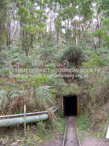
Photograph - Digital Photograph, Marguerite Marshall, One Tree Hill Mine, Smiths Gully, 8 June 2006
... Marshall-King) Collection...Gold mining...One Tree Hill Mine...smiths gully...Marshall.; p53 Though still a working mine, One Tree Hill Mine at Smiths Gully, now stands in a tranquil reserve surrounded by bush and native animals - in contrast to its heyday. ...Nillumbik Now and Then (Marshall-King) Collection Gold mining One Tree Hill Mine smiths gully Born digital image file One Tree Hill Mine, Smiths Gully Photograph Digital Photograph Marguerite Marshall Marguerite Marshall Alan King ...Gold was discovered on One Tree Hill in 1854. The site has been worked intermittently until fairly recent times. Published: Nillumbik Now and Then / Marguerite Marshall 2008; photographs Alan King with Marguerite Marshall.; p53 Though still a working mine, One Tree Hill Mine at Smiths Gully, now stands in a tranquil reserve surrounded by bush and native animals - in contrast to its heyday. In the mid 19th century, when the mine was part of the Caledonia Goldfields, hundreds of men in search of their fortune worked the alluvial gold in the Yarra River, its tributaries and the reefs that made up the goldfields. Miner Stan Bone, assisted by Wilfred Haywood, is the last of the independent gold miners in the area and still uses the quartz crushing battery as miners did when gold was first discovered in the area in 1851.1 Stan, who is the last of six generations of miners in his family, was aged 17 when he began mining on his father Alex’ mine, The Golden Crown in Yarrambat. These days, after blasting the gold-bearing rock in Mystery Reef, one of the four reefs at One Tree Hill, Stan transports it around five kilometres by tip truck to the Black Cameron Mine for crushing. There he uses water from the waterlogged mine, (which still contains gold), as the Happy Valley Creek at One Tree Hill is usually dry.2 The One Tree Hill Mine has been worked for close to a century since it opened around the late 1850s.3 The Swedish Reef was its most productive reef and one of the largest in the area. Around 1859, extractions included 204 ounces (5.8kg) of gold, won from 57 pounds (26kg) of stone.4 Then during World War Two, Stan’s uncle, Bill Wallace, and Alex Bone, closed the mine. In 1973, Stan, with his Uncle Bill, reopened the Black Cameron Mine and worked there until 1988. Stan resumed mining One Tree Hill in 1998. As late as the 1920s gold was picked up by chance! When crossing a gully on his way to vote at the St Andrews Primary School, Bill Joyce picked up some quartz containing gold. This site was to become the Black Cameron Mine. The Caledonia Diggings, named after Scotland’s ancient name by local Scots, began around Market Square (now Smiths Gully) and included Queenstown (St Andrews), Kingstown (Panton Hill) and Diamond Creek. There were also poorer bearing fields in Kangaroo Ground and Swipers Gully (now Research). * None of these compared in riches to the Ballarat and Bendigo fields5, but the Caledonia Diggings continued intermittently for close to 100 years. Gold was discovered in Victoria following a bid to stem the disappearance of much needed workmen to the New South Wales diggings. Several businessmen offered a reward of £200, for the discovery of gold within 200 miles (322 km) of Melbourne. Late in June 1851, gold was first discovered at Andersons Creek, Warrandyte. Then in 1854, George Boston and two other men discovered gold at Smiths Gully. Gold transformed the quiet districts, with a constant flow of families and vehicles on the dirt tracks en route to the Caledonia Diggings. Three thousand people worked the gullies in Market Square, including about 1000 Chinese miners. The square established its own police, mining warden, gold battery, school, shops and cemetery and grog flowed. Market Square flourished until the middle 1860s. Bullocks transported quartz from the Caledonia Goldfields to the crushing machinery at the Queenstown/St Andrews Battery, near Smiths Gully Cemetery. It was destroyed by bushfire in 1962. By the late 1850s, most early alluvial fields were in decline, but minor rushes continued until around 1900 and some until the early 1940s. Some miners did well, although most earned little from their hard labour in the harsh and primitive conditions.6 But according to historian, Mick Woiwod, the gold fields helped to democratise society, as individuals from all walks of life were forced to share experiences, and the ability to succeed, depended less on inherited wealth or social rank.This collection of almost 130 photos about places and people within the Shire of Nillumbik, an urban and rural municipality in Melbourne's north, contributes to an understanding of the history of the Shire. Published in 2008 immediately prior to the Black Saturday bushfires of February 7, 2009, it documents sites that were impacted, and in some cases destroyed by the fires. It includes photographs taken especially for the publication, creating a unique time capsule representing the Shire in the early 21st century. It remains the most recent comprehenesive publication devoted to the Shire's history connecting local residents to the past. nillumbik now and then (marshall-king) collection, gold mining, one tree hill mine, smiths gully -
 Eltham District Historical Society Inc
Photograph - Digital Photograph, Alan King, Former St Andrews State School No. 128 building, 23 January 2008
... Marshall-King) Collection...St Andrews...Queenstown State School No. 128...Smiths Gully...Gully State school illustrates the common 19th and early 20th century practice of relocating State school buildings based on need. The school building is historically and socially significant because it served the local community, as a school, from 1887 to the late 1970s/early 1980s and because since then it has been used for other community purposes. Covered under Heritage Overlay, Nillumbik Planning Scheme. Published: Nillumbik Now and Then / Marguerite Marshall...Nillumbik Now and Then (Marshall-King) Collection St Andrews Queenstown State School No. 128 Smiths Gully State School Born digital image file Former St Andrews State School No. 128 building Photograph Digital Photograph Alan King Alan King Marguerite Marshall ...In 1858 the Caledonia Common School No.128 opened at Queenstown, about 1.6km upstream on Diamond Creek from the present site of the old St Andrews school. The school was renamed Queenstown Common School No. 128 in 1867. In 1882, due to declining numbers of pupils at Smiths Gully and increasing numbers in Queenstown the school was moved from a leased building, owned by Head Teacher Robert Harris, into a new larger building on the corner of School and Heidelberg-Kinglake roads which incorporated the original single room school building, which had been moved from Smiths Gully, and included a teacher’s three-roomed residence. In 1887 the school was replaced by the Queenstown State School No. 128. The school and town were renamed St Andrews in 1952. In 1983 a new school was built, 500 metres south of the old school and the old school became the St Andrews Community Centre. Of significance is the c1887 school building (including part of the c1876 Smith's Gully school moved to the site and incorporated into the c1887 school building), the c1911 new room, the c1929 cloakroom, the c1930 renovations, the c1956 new infant room; the c1961 office and storeroom, as well as the c1950 Himalayan Cedar tree and the entire site to the title boundaries. The school building is historically significant for its links with the early settlement of the area and because its use of materials from the former Smith's Gully State school illustrates the common 19th and early 20th century practice of relocating State school buildings based on need. The school building is historically and socially significant because it served the local community, as a school, from 1887 to the late 1970s/early 1980s and because since then it has been used for other community purposes. Covered under Heritage Overlay, Nillumbik Planning Scheme. Published: Nillumbik Now and Then / Marguerite Marshall 2008; photographs Alan King with Marguerite Marshall.; p69This collection of almost 130 photos about places and people within the Shire of Nillumbik, an urban and rural municipality in Melbourne's north, contributes to an understanding of the history of the Shire. Published in 2008 immediately prior to the Black Saturday bushfires of February 7, 2009, it documents sites that were impacted, and in some cases destroyed by the fires. It includes photographs taken especially for the publication, creating a unique time capsule representing the Shire in the early 21st century. It remains the most recent comprehenesive publication devoted to the Shire's history connecting local residents to the past. nillumbik now and then (marshall-king) collection, st andrews, queenstown state school no. 128, smiths gully state school -
 Eltham District Historical Society Inc
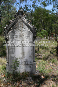
Photograph - Digital Photograph, Alan King, Queenstown Cemetery, Smiths Gully Road, St Andrews, 28 December 2007
... Marshall-King) Collection...David Band...Eliza Smith...Gravestones...John Cork Knell...Queenstown Cemetery...Smiths Gully...Nillumbik Now and Then (Marshall-King) Collection David Band Eliza Smith Gravestones John Cork Knell Queenstown Cemetery Smiths Gully Road St Andrews William Band Born digital image file Queenstown Cemetery, Smiths Gully Road, St Andrews Photograph Digital Photograph Alan King Alan King Marguerite Marshall ...The discovery of gold in Smyth's Creek in 1854 and subsequent gold rush to the Caledonia diggings led to the establishment of Queenstown (present day St Andrews). The first recorded burial was July 31st, 1861 and it was officially declared a Cemetery Reserve in 1866. Many graves are unmarked and unrecorded including many Chinese and other itinerant miners. The cemetery was closed for new burials in 1851. The last recorded burial was in 1981 in an existing family grave. In Loving memory of David Band Died 30th Decr. 1862, aged 51 years. John Cork Knell Died 11th April 1867, aged 42 years. Eliza Smith Died 20th Jany. 1874, aged 3 1/2 years. William Band Died 20th Feby. 1883, aged 51 years. Published: Nillumbik Now and Then / Marguerite Marshall 2008; photographs Alan King with Marguerite Marshall.; p73 The discovery of gold at Smyth’s Creek* in 1854 brought 3000 people to the area in search of their fortunes.1 However in the harsh conditions many miners and their families died young, and were buried in unmarked graves. Their stories died with them but by 1861, the first burial was recorded at the Queenstown Cemetery – that of William Dalrymple aged 65 – although the cemetery was only officially declared a reserve in 1866. Even before this in 1856, a double burial had been recorded for the twin baby daughters of George Harrison at Market Square, the miners’ settlement – presumably where the cemetery is today. In 1951 the Queenstown Cemetery at 70 Smiths Gully Road, Smiths Gully, closed for burials. However the last burial in a family plot, that of Grace Evelyn Smith, occurred in 1981. Today only 55 headstones remain, but more than 380 burials are recorded. Remnant bushland dominates the cemetery where many graves are merely mounds and others have been damaged by vandalism and the neglect of time. Bushfire in 1962 destroyed the picket fencing, grave markers and cypress boundary planted in the early 1900s. The box/stringybark woodland in the 1.7 hectare Cemetery Reserve is regrowth from then and the indigenous and heritage vegetation is protected. Thanks to the volunteer Cemetery Trust and Friends & Relations of Queenstown Cemetery, the cemetery is maintained, stories recorded and the burial index corrected and expanded.2 Close by the cemetery on the site of today’s Peter Franke Picnic and Nature Reserve stood Market Square, the Caledonia Diggings village of tents and stores, the forerunner of Queenstown, now St Andrews. Many of the Caledonia Diggings miners were Chinese, many of whom, with itinerant prospectors, were buried in unmarked graves. Histories are being recorded of other immigrants, mainly English and German, who settled after the gold rush, some of whose descendants fought and died in the two world wars. Names on many headstones are also recorded on the district’s roads, reserves and war memorials such as Motschall, Joyce, Howard and Coutie. The oldest surviving tombstone is that of Scot, David Band who died in 1862 at 51 years. His oldest daughter Elizabeth, with husband John Knell, owned the Queenstown Hotel and the post office. Child-rearing in a colonial gold town was often tragically difficult, as demonstrated in the first 20 years, when 41% of the 34 burials recorded were children. Settlers endured harsh conditions graphically illustrated with the deaths of Annie Joyce at 30 years and of her family. Annie was married to gold miner Walter Joyce. Their third child Walter, born in 1886, died in March 1887. Eight months later Annie died of breast cancer. Walter died in 1909, aged 53, of miner’s phthisic caused by stone dust destroying his lungs. It was so hard to make a living that burials were usually held from 2.30 pm to allow mourners to work a day before paying their last respects.3 Most burials before 1890 were recorded as Anglicans, as the only church on the Caledonia Diggings was the Church of St Andrew, until 1897, when the Primitive Methodist Church came to Panton Hill. Generally miners came to better themselves, but some, like Grace Hopkinson (nee Milward), born in England in 1828, came from a well-off and educated family. According to family legend Grace emigrated with husband William, to live in a tent, but had kept her personally embossed sterling silver cutlery service. Amid the tough environment were some successes like that reported in The Evelyn Observer April/May 1901 of miner William Hopkinson who was buried at the cemetery in 1912 aged 81. The Observer stated that Hopkinson ‘recently dropped across another find in his claim at One Tree Hill’. The lump of gold found this time weighed more than half a kilo. Mr Hopkinson referred to it as ‘another little speck’. *Today’s Smiths GullyThis collection of almost 130 photos about places and people within the Shire of Nillumbik, an urban and rural municipality in Melbourne's north, contributes to an understanding of the history of the Shire. Published in 2008 immediately prior to the Black Saturday bushfires of February 7, 2009, it documents sites that were impacted, and in some cases destroyed by the fires. It includes photographs taken especially for the publication, creating a unique time capsule representing the Shire in the early 21st century. It remains the most recent comprehenesive publication devoted to the Shire's history connecting local residents to the past. nillumbik now and then (marshall-king) collection, david band, eliza smith, gravestones, john cork knell, queenstown cemetery, smiths gully road, st andrews, william band -
 Eltham District Historical Society Inc
Photograph - Digital Photograph, Alan King, Kinglake National Park, 27 March 2008
... Marshall-King) Collection...Kinglake National Park...Jehosaphat Gully...Fern gullies around Jehosaphat Gully Covered under National Estate. Published: Nillumbik Now and Then / Marguerite Marshall 2008; photographs Alan King with Marguerite Marshall.; p125 The magnificent Kinglake National Park, fringing Nillumbik’s north, is the largest national park close to Melbourne. ...Nillumbik Now and Then (Marshall-King) Collection Kinglake National Park Jehosaphat Gully Born digital image file Kinglake National Park Photograph Digital Photograph Alan King Alan King Marguerite Marshall ...Fern gullies around Jehosaphat Gully Covered under National Estate. Published: Nillumbik Now and Then / Marguerite Marshall 2008; photographs Alan King with Marguerite Marshall.; p125 The magnificent Kinglake National Park, fringing Nillumbik’s north, is the largest national park close to Melbourne. Thanks to the vision and hard work of a band of local people, the park was created from what was rapidly becoming degraded land. Seeing a threat to Kinglake’s indigenous flora and fauna, several prominent local people campaigned for a national park, which was established in 1928.1 Since then, the park has grown through donations and acquisitions of land, from around 13,800 acres of land (5585ha) to 22,360 hectares. The Sugarloaf and Everard Blocks – of almost 8000 hectares – stand in Nillumbik and the park extends into Mitchell and Murrundindi Shires and the City of Whittlesea. Mt Everard commemorates William Hugh Everard, State member for Evelyn when the park was established. Before 1928, European settlers had degraded the Kinglake area, which was named after the celebrated English author and lawyer, Alexander William Kinglake. Remains of gold shafts and diggings in the park are reminders of Kinglake’s first settlers, who hoped to strike it rich at the gold diggings. But like other gold fields in this shire, they proved not very lucrative and soon timber cutting replaced mining in importance. However, before long, the accessible timber supply ran out, so in the 1920s agriculture took over – particularly potatoes and berry fruits – which involved large-scale clearing.2 The park’s instigator was retired Melbourne University Professor of Music, William Laver.3 As chair of the Kinglake Progress Association he began negotiations to have crown lands on the southern scarp of the Great Dividing Range reserved as a national park. Even before the park was proclaimed, from 1927, KPA members cut tracks to the major scenic points. Professor Laver was one of several people who gave land for the park, donating around 50 acres (20ha), including the Jehosaphat Gully.4 Laver chaired the park’s first Committee of Management, which raised money to employ a ranger and provide facilities, including tracks and roads for fire protection vehicles, toilets and shelters. The committee charged fees for firewood collection, some grazing of livestock, and visitor entrance, and obtained small State Government and Eltham Shire grants. In 1957 the State Government provided revenue for national parks. Then, in 1975, the State Government took over the management and the Committee of Management became an advisory committee, which disbanded in 1978. Originally, the park covered crown land in the Shires of Eltham and Whittlesea; then Wombelano Falls in Yea and other areas were added. In 1970 the park extended into the Shires of Eltham, Healesville, Whittlesea and Yea.5 Bush fires have been an ongoing problem. In 1939 hundreds of eucalypts and acacias had to be sown around the Jehosaphat Gully to rejuvenate the forest. To manage bushfires, the Committee of Management, then the State Government, worked closely with the Forestry Commission, shire councils and local fire brigades. Early national parks focussed on recreation. But by the 1980s, conservation, education and scientific research became more important, playing a vital role in preserving representative samples of the natural environment. Each year many thousands of people use the park’s extensive network of walking tracks amongst the protected plant and animal life as well as camping, cycling and horse riding. The park, along the slopes of the Great Dividing Range, has lookouts revealing magnificent views of the Melbourne skyline, Port Phillip Bay, the Yarra Valley and the You Yangs. Vegetation in the Masons Falls area includes messmate forest, Austral grass-trees, ferns and Hazel Pomaderris. In spring, orchids, lilies, everlasting daisies, correas, grevillea and heath appear. Around Jehosaphat Gully are wet and dry forest, fern gullies and banksia. Animal life includes wallabies, kangaroos, koalas, echidnas, possums, gliders and bandicoots. Male lyrebirds can be heard mimicking in the Jehosaphat Gully, particularly in the Everard Block in winter.This collection of almost 130 photos about places and people within the Shire of Nillumbik, an urban and rural municipality in Melbourne's north, contributes to an understanding of the history of the Shire. Published in 2008 immediately prior to the Black Saturday bushfires of February 7, 2009, it documents sites that were impacted, and in some cases destroyed by the fires. It includes photographs taken especially for the publication, creating a unique time capsule representing the Shire in the early 21st century. It remains the most recent comprehenesive publication devoted to the Shire's history connecting local residents to the past. nillumbik now and then (marshall-king) collection, kinglake national park, jehosaphat gully -
 Bendigo Historical Society Inc.
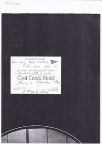
Photograph - LONG GULLY HISTORY GROUP COLLECTION: LONG GULLY SENIOR CITIZENS 24/10/1982
... Gully Senior Citizens 24/10/1982... Coal Creek Motel... Ethel Keith... Sadie Peers... Iris Swift... Nell Finch... Mary Webber... Roy Rosewarne... Jack Harper... Doss Rosewarne... Ethel Haig... Val Fieldew... Mary Wilson... Bill Wilson... Mrs E brown... Mrs Elsie Marshall...Gully Senior Citizens photographed outside a building. they were on a bus tour to Korumburra, oct 24-30-1952. They are: Ethel Keith, Sadie Peers, Iris Swift, Nell Finch, Mary Webber, Roy Rosewarne, Jack Harper, Doss Rosewarne, Ethel Haig, Val Fieldew, Mary Wilson, Bill Wilson, Mrs E brown, Mrs Elsie Marshall, Mrs H Bond, Leo Hambly D, Vi Cameron, Bonna Liddel, Doris Stanford, Bev Liddel, Lila Robins, Vene Long, Sophie Reilly, M?...Gully Senior Citizens photographed outside a building. they were on a bus tour to Korumburra, oct 24-30-1952. They are: Ethel Keith, Sadie Peers, Iris Swift, Nell Finch, Mary Webber, Roy Rosewarne, Jack Harper, Doss Rosewarne, Ethel Haig, Val Fieldew, Mary Wilson, Bill Wilson, Mrs E brown, Mrs Elsie Marshall, Mrs H Bond, Leo Hambly D, Vi Cameron, Bonna Liddel, Doris Stanford, Bev Liddel, Lila Robins, Vene Long, Sophie Reilly, M? ...Group of Long Gully Senior Citizens photographed outside a building. they were on a bus tour to Korumburra, oct 24-30-1952. They are: Ethel Keith, Sadie Peers, Iris Swift, Nell Finch, Mary Webber, Roy Rosewarne, Jack Harper, Doss Rosewarne, Ethel Haig, Val Fieldew, Mary Wilson, Bill Wilson, Mrs E brown, Mrs Elsie Marshall, Mrs H Bond, Leo Hambly D, Vi Cameron, Bonna Liddel, Doris Stanford, Bev Liddel, Lila Robins, Vene Long, Sophie Reilly, M?t Harper, Alida Rattcliff, Cathie Logan, Jean OToole, Dorrie Crossley, Doris Mitchell, Bill Jurey, Eunice Pervis, Belle Jurey, Phyllis Cornish, Bill Cornish, Mary Harris, Leah Comte, Rex Ratcliff, Laurie OToole, Alan Crossley, Ula Angove, Amy Rowe and Dot Birrel.bendigo, history, long gully history group, the long gully history group - long gully senior citizens 24/10/1982, coal creek motel, ethel keith, sadie peers, iris swift, nell finch, mary webber, roy rosewarne, jack harper, doss rosewarne, ethel haig, val fieldew, mary wilson, bill wilson, mrs e brown, mrs elsie marshall, mrs h bond, leo hambly d, vi cameron, bonna liddel, doris stanford, bev liddel, lila robins, vene long, sophie reilly, m?t harper, alida rattcliff, cathie logan, jean otoole, dorrie crossley, doris mitchell, bill jurey, eunice pervis, belle jurey, phyllis cornish, bill cornish, mary harris, leah comte, rex ratcliff, laurie otoole, alan crossley, ula angove, amy rowe, dot birrel -
 Eltham District Historical Society Inc
Photograph, Albert Tucker - Artist, Haleys Gully Rd., Hurstbridge, 1971
... Marshall (1971). The collection of over 500 images is held in partnership between Eltham District Historical Society and Yarra Plenty Regional Library (Eltham Library) and is now formally known as the 'The Shire of Eltham Pioneers Photograph Collection.' It is significant in being the first community sourced collection representing the places and people of the Shire's first one hundred years. albert tucker, eltham local characters, sepp, shire of eltham pioneers photograph collection Digital image Various prints and colour reversal films Albert Tucker - Artist, Haleys Gully Rd., Hurstbridge Photograph ...This photo forms part of a collection of photographs gathered by the Shire of Eltham for their centenary project book,"Pioneers and Painters: 100 years of the Shire of Eltham" by Alan Marshall (1971). The collection of over 500 images is held in partnership between Eltham District Historical Society and Yarra Plenty Regional Library (Eltham Library) and is now formally known as the 'The Shire of Eltham Pioneers Photograph Collection.' It is significant in being the first community sourced collection representing the places and people of the Shire's first one hundred years.Digital image Various prints and colour reversal filmsalbert tucker, eltham local characters, sepp, shire of eltham pioneers photograph collection -
 Eltham District Historical Society Inc
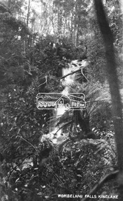
Negative - Photograph, Wombelano Falls, Kinglake
... gullies in the Kinglake National Park. This image probably produced as a postcard. This photo forms part of a collection of photographs gathered by the Shire of Eltham for their centenary project book,"Pioneers and Painters: 100 years of the Shire of Eltham" by Alan Marshall (1971). ...Wombelano Falls is framed by a eucalypt forest and lush gullies in the Kinglake National Park. This image probably produced as a postcard.This photo forms part of a collection of photographs gathered by the Shire of Eltham for their centenary project book,"Pioneers and Painters: 100 years of the Shire of Eltham" by Alan Marshall (1971). The collection of over 500 images is held in partnership between Eltham District Historical Society and Yarra Plenty Regional Library (Eltham Library) and is now formally known as 'The Shire of Eltham Pioneers Photograph Collection.' It is significant in being the first community sourced collection representing the places and people of the Shire's first one hundred years.Digital image 4 x 5 inch B&W Negkinglake national park, shire of eltham pioneers photograph collection, water falls, wombelano falls -
 Eltham District Historical Society Inc
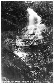
Photograph, Kinglake National Park, Wombelano Falls
... gullies in the Kinglake National Park. This image probably produced as a postcard. This photo forms part of a collection of photographs gathered by the Shire of Eltham for their centenary project book,"Pioneers and Painters: 100 years of the Shire of Eltham" by Alan Marshall (1971). ...Wombelano Falls is framed by a eucalypt forest and lush gullies in the Kinglake National Park. This image probably produced as a postcard.This photo forms part of a collection of photographs gathered by the Shire of Eltham for their centenary project book,"Pioneers and Painters: 100 years of the Shire of Eltham" by Alan Marshall (1971). The collection of over 500 images is held in partnership between Eltham District Historical Society and Yarra Plenty Regional Library (Eltham Library) and is now formally known as 'The Shire of Eltham Pioneers Photograph Collection.' It is significant in being the first community sourced collection representing the places and people of the Shire's first one hundred years.Digital imagesepp, shire of eltham pioneers photograph collection, kinglake, kinglake national park, wombeland falls, waterfall, postcard, forest -
 Eltham District Historical Society Inc
Photograph, Kinglake National Park, Fern Gully
... Marshall (1971). The collection of over 500 images is held in partnership between Eltham District Historical Society and Yarra Plenty Regional Library (Eltham Library) and is now formally known as the 'The Shire of Eltham Pioneers Photograph Collection.' It is significant in being the first community sourced collection representing the places and people of the Shire's first one hundred years. sepp shire of eltham pioneers photograph collection kinglake kinglake national park fern gully Digital image Kinglake National Park, Fern Gully. ...Source: Mrs. McMinn, Kinglake.This photo forms part of a collection of photographs gathered by the Shire of Eltham for their centenary project book,"Pioneers and Painters: 100 years of the Shire of Eltham" by Alan Marshall (1971). The collection of over 500 images is held in partnership between Eltham District Historical Society and Yarra Plenty Regional Library (Eltham Library) and is now formally known as the 'The Shire of Eltham Pioneers Photograph Collection.' It is significant in being the first community sourced collection representing the places and people of the Shire's first one hundred years.Digital imagesepp, shire of eltham pioneers photograph collection, kinglake, kinglake national park, fern gully -
 Eltham District Historical Society Inc
Photograph, Kinglake National Park, Bald Hill, Kiosk Road
... Marshall (1971). The collection of over 500 images is held in partnership between Eltham District Historical Society and Yarra Plenty Regional Library (Eltham Library) and is now formally known as the 'The Shire of Eltham Pioneers Photograph Collection.' It is significant in being the first community sourced collection representing the places and people of the Shire's first one hundred years. sepp shire of eltham pioneers photograph collection kinglake kinglake national park fern gully bald hill kiosk road Digital image Kinglake National Park, Bald Hill, Kiosk Road. ...Source: Dr. Edith J. Hewitt, StrathewenThis photo forms part of a collection of photographs gathered by the Shire of Eltham for their centenary project book,"Pioneers and Painters: 100 years of the Shire of Eltham" by Alan Marshall (1971). The collection of over 500 images is held in partnership between Eltham District Historical Society and Yarra Plenty Regional Library (Eltham Library) and is now formally known as the 'The Shire of Eltham Pioneers Photograph Collection.' It is significant in being the first community sourced collection representing the places and people of the Shire's first one hundred years.Digital imagesepp, shire of eltham pioneers photograph collection, kinglake, kinglake national park, fern gully, bald hill, kiosk road -
 Eltham District Historical Society Inc
Photograph, Kinglake National Park, Fern Gully
... Marshall (1971). The collection of over 500 images is held in partnership between Eltham District Historical Society and Yarra Plenty Regional Library (Eltham Library) and is now formally known as the 'The Shire of Eltham Pioneers Photograph Collection.' It is significant in being the first community sourced collection representing the places and people of the Shire's first one hundred years. sepp shire of eltham pioneers photograph collection kinglake kinglake national park fern gully Digital image Kinglake National Park, Fern Gully. ...Source: Mrs. McMinn, Kinglake.This photo forms part of a collection of photographs gathered by the Shire of Eltham for their centenary project book,"Pioneers and Painters: 100 years of the Shire of Eltham" by Alan Marshall (1971). The collection of over 500 images is held in partnership between Eltham District Historical Society and Yarra Plenty Regional Library (Eltham Library) and is now formally known as the 'The Shire of Eltham Pioneers Photograph Collection.' It is significant in being the first community sourced collection representing the places and people of the Shire's first one hundred years.Digital imagesepp, shire of eltham pioneers photograph collection, kinglake, kinglake national park, fern gully -
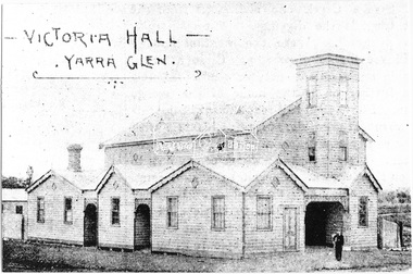 Eltham District Historical Society Inc
Photograph, Victoria Hall - Yarra Glen, 1893 (reproduced from "The Leader", Jan. 6th, 1894, page 31)
... Motschall (nee Marjorie Smith), Long Gully Road, Panton Hill This photo forms part of a collection of photographs gathered by the Shire of Eltham for their centenary project book,"Pioneers and Painters: 100 years of the Shire of Eltham" by Alan Marshall (1971). ...Source: Mrs. E.W. Motschall (nee Marjorie Smith), Long Gully Road, Panton HillThis photo forms part of a collection of photographs gathered by the Shire of Eltham for their centenary project book,"Pioneers and Painters: 100 years of the Shire of Eltham" by Alan Marshall (1971). The collection of over 500 images is held in partnership between Eltham District Historical Society and Yarra Plenty Regional Library (Eltham Library) and is now formally known as the 'The Shire of Eltham Pioneers Photograph Collection.' It is significant in being the first community sourced collection representing the places and people of the Shire's first one hundred years.Digital imagesepp, shire of eltham pioneers photograph collection, yarra glen, cave hill, steels creek -
 Eltham District Historical Society Inc
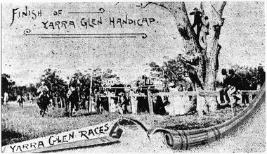
Photograph, Finish of Yarra Glen Handicap, Yarra Glen Races, 1893 (reproduced from "The Leader", Jan. 6th, 1894, page 31)
... Motschall (nee Marjorie Smith), Long Gully Road, Panton Hill This photo forms part of a collection of photographs gathered by the Shire of Eltham for their centenary project book,"Pioneers and Painters: 100 years of the Shire of Eltham" by Alan Marshall (1971). ...Source: Mrs. E.W. Motschall (nee Marjorie Smith), Long Gully Road, Panton HillThis photo forms part of a collection of photographs gathered by the Shire of Eltham for their centenary project book,"Pioneers and Painters: 100 years of the Shire of Eltham" by Alan Marshall (1971). The collection of over 500 images is held in partnership between Eltham District Historical Society and Yarra Plenty Regional Library (Eltham Library) and is now formally known as the 'The Shire of Eltham Pioneers Photograph Collection.' It is significant in being the first community sourced collection representing the places and people of the Shire's first one hundred years.Digital imagesepp, shire of eltham pioneers photograph collection, yarra glen, cave hill, steels creek, yarra glen races, yarra glen handicap -
 Eltham District Historical Society Inc
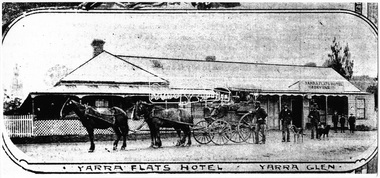
Photograph, Yarra Flats Hotel, Yarra Glen, 1893 (reproduced from "The Leader", Jan. 6th, 1894, page 31)
... Motschall (nee Marjorie Smith), Long Gully Road, Panton Hill This photo forms part of a collection of photographs gathered by the Shire of Eltham for their centenary project book,"Pioneers and Painters: 100 years of the Shire of Eltham" by Alan Marshall (1971). ...Source: Mrs. E.W. Motschall (nee Marjorie Smith), Long Gully Road, Panton HillThis photo forms part of a collection of photographs gathered by the Shire of Eltham for their centenary project book,"Pioneers and Painters: 100 years of the Shire of Eltham" by Alan Marshall (1971). The collection of over 500 images is held in partnership between Eltham District Historical Society and Yarra Plenty Regional Library (Eltham Library) and is now formally known as the 'The Shire of Eltham Pioneers Photograph Collection.' It is significant in being the first community sourced collection representing the places and people of the Shire's first one hundred years.Digital imagesepp, shire of eltham pioneers photograph collection, yarra glen, cave hill, steels creek, yarra flats hotel -
 Eltham District Historical Society Inc
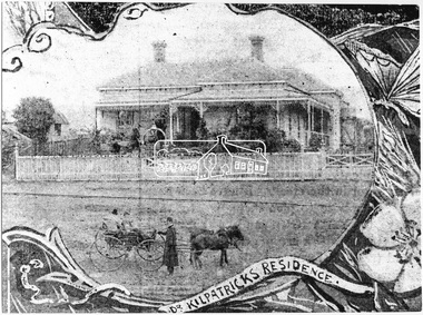
Photograph, Dr. Kilpatrick's Residence, Yarra Glen, 1893 (reproduced from "The Leader", Jan. 6th, 1894, page 31), 1894
... Motschall (nee Marjorie Smith), Long Gully Road, Panton Hill This photo forms part of a collection of photographs gathered by the Shire of Eltham for their centenary project book,"Pioneers and Painters: 100 years of the Shire of Eltham" by Alan Marshall (1971). ...Illustrative photograph of Dr. Kilpatricks residence at Yarra Glen. Reproduced as one of a montage in "The Leader" January 6th, 1894 page 31. The house is fenced with an established front garden. A horse and cart and people pose in the foreground. Dr. William Kilpatrick was in practice around Yarra Glen & Lilydale during the late 1880s - 90s. He married Honorah Farrell, the daughter of the local publican and a son, William was born to them in Omeo, 1906. He died in Castlemaine in 1925 Source: Mrs. E.W. Motschall (nee Marjorie Smith), Long Gully Road, Panton HillThis photo forms part of a collection of photographs gathered by the Shire of Eltham for their centenary project book,"Pioneers and Painters: 100 years of the Shire of Eltham" by Alan Marshall (1971). The collection of over 500 images is held in partnership between Eltham District Historical Society and Yarra Plenty Regional Library (Eltham Library) and is now formally known as the 'The Shire of Eltham Pioneers Photograph Collection.' It is significant in being the first community sourced collection representing the places and people of the Shire's first one hundred years.Digital imagesepp, shire of eltham pioneers photograph collection, yarra glen, cave hill, dr. kilpatrick, "the leader" -
 Eltham District Historical Society Inc
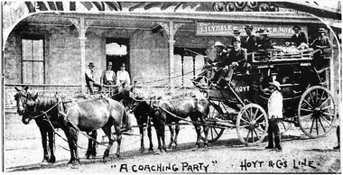
Photograph, "A Coaching Party" - Hoyt & Co.'s Line, 1893 (reproduced from "The Leader", Jan. 6th, 1894, page 31)
... Motschall (nee Marjorie Smith), Long Gully Road, Panton Hill This photo forms part of a collection of photographs gathered by the Shire of Eltham for their centenary project book,"Pioneers and Painters: 100 years of the Shire of Eltham" by Alan Marshall (1971). ...Source: Mrs. E.W. Motschall (nee Marjorie Smith), Long Gully Road, Panton HillThis photo forms part of a collection of photographs gathered by the Shire of Eltham for their centenary project book,"Pioneers and Painters: 100 years of the Shire of Eltham" by Alan Marshall (1971). The collection of over 500 images is held in partnership between Eltham District Historical Society and Yarra Plenty Regional Library (Eltham Library) and is now formally known as the 'The Shire of Eltham Pioneers Photograph Collection.' It is significant in being the first community sourced collection representing the places and people of the Shire's first one hundred years.Digital imagesepp, shire of eltham pioneers photograph collection, yarra glen, cave hill, steels creek, hoyt & co. -
 Eltham District Historical Society Inc
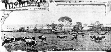
Photograph, Holstein Cattle - Cave Hill, 1893 (reproduced from "The Leader", Jan. 6th, 1894, page 31)
... Motschall (nee Marjorie Smith), Long Gully Road, Panton Hill This photo forms part of a collection of photographs gathered by the Shire of Eltham for their centenary project book,"Pioneers and Painters: 100 years of the Shire of Eltham" by Alan Marshall (1971). ...Source: Mrs. E.W. Motschall (nee Marjorie Smith), Long Gully Road, Panton HillThis photo forms part of a collection of photographs gathered by the Shire of Eltham for their centenary project book,"Pioneers and Painters: 100 years of the Shire of Eltham" by Alan Marshall (1971). The collection of over 500 images is held in partnership between Eltham District Historical Society and Yarra Plenty Regional Library (Eltham Library) and is now formally known as the 'The Shire of Eltham Pioneers Photograph Collection.' It is significant in being the first community sourced collection representing the places and people of the Shire's first one hundred years.Digital imagesepp, shire of eltham pioneers photograph collection, yarra glen, cave hill, steels creek, holstein cattle -
 Eltham District Historical Society Inc
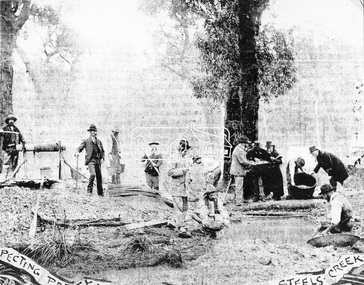
Photograph, A Prospecting Party, Steels Creek, 1893 (reproduced from "The Leader", Jan. 6th, 1894, page 31)
... Motschall (nee Marjorie Smith), Long Gully Road, Panton Hill This photo forms part of a collection of photographs gathered by the Shire of Eltham for their centenary project book,"Pioneers and Painters: 100 years of the Shire of Eltham" by Alan Marshall (1971). ...Source: Mrs. E.W. Motschall (nee Marjorie Smith), Long Gully Road, Panton HillThis photo forms part of a collection of photographs gathered by the Shire of Eltham for their centenary project book,"Pioneers and Painters: 100 years of the Shire of Eltham" by Alan Marshall (1971). The collection of over 500 images is held in partnership between Eltham District Historical Society and Yarra Plenty Regional Library (Eltham Library) and is now formally known as the 'The Shire of Eltham Pioneers Photograph Collection.' It is significant in being the first community sourced collection representing the places and people of the Shire's first one hundred years.Digital imagesepp, shire of eltham pioneers photograph collection, yarra glen, cave hill, steels creek, gold miners -
 Eltham District Historical Society Inc
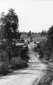
Photograph, Tom Prior, Research Gully Bridge, Research Gully Road, Research, c.1895
... Gully Road. This photo forms part of a collection of photographs gathered by the Shire of Eltham for their centenary project book,"Pioneers and Painters: 100 years of the Shire of Eltham" by Alan Marshall (1971). ...Research Gully Bridge. At time of collection (1970) Ingrams Road was formerly Research Gully Road.This photo forms part of a collection of photographs gathered by the Shire of Eltham for their centenary project book,"Pioneers and Painters: 100 years of the Shire of Eltham" by Alan Marshall (1971). The collection of over 500 images is held in partnership between Eltham District Historical Society and Yarra Plenty Regional Library (Eltham Library) and is now formally known as the 'The Shire of Eltham Pioneers Photograph Collection.' It is significant in being the first community sourced collection representing the places and people of the Shire's first one hundred years. The Reynolds family were early settlers in Research. The Reynolds/ Prior collection of photographs were taken by Tom Prior, the maternal uncle of Ivy Reynolds, around 1900 and the 60 photos in the album give a fine overview of many of the landmarks of Research and Eltham over 100 years ago. lvy lived in the family home for many years at 106 Thompson Cres Research. Ivy's father, Ernst Richard Reynolds and grandfather, Richard Reynolds, lived at the same address. Ivy's father Richard worked for Mr. Trail on his property in Research. Reynolds Road is named after the family. Mr Tom Prior (wife Eva) worked at the Melbourne zoo. He was very innovative and made his own camera, using the black cloth hood to exclude the light. The photographs are a reminder of the rural nature of Research and Eltham and its rich heritage.Digital imageshire of eltham pioneers photograph collection, research (vic.), ingrams road, research gully bridge, research gully road, aqueduct, reynolds prior collection -
 Eltham District Historical Society Inc
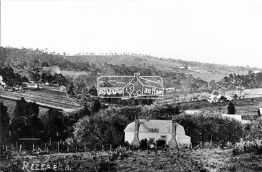
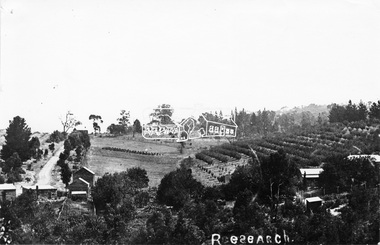
Photograph, Research, Vic
... Gully Road. Source: Mrs. E.R. Reynolds, Thompson Crescent, Research This photo forms part of a collection of photographs gathered by the Shire of Eltham for their centenary project book,"Pioneers and Painters: 100 years of the Shire of Eltham" by Alan Marshall (1971). ...Research. House in centre foreground is same house as centre left Ref. 512. Looking about south-south west, down Research Gully Road. Source: Mrs. E.R. Reynolds, Thompson Crescent, ResearchThis photo forms part of a collection of photographs gathered by the Shire of Eltham for their centenary project book,"Pioneers and Painters: 100 years of the Shire of Eltham" by Alan Marshall (1971). The collection of over 500 images is held in partnership between Eltham District Historical Society and Yarra Plenty Regional Library (Eltham Library) and is now formally known as the 'The Shire of Eltham Pioneers Photograph Collection.' It is significant in being the first community sourced collection representing the places and people of the Shire's first one hundred years.Digital imagesepp, shire of eltham pioneers photograph collection, research (vic.) -
 Eltham District Historical Society Inc
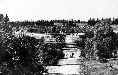
Photograph, Research Gully Road
... Marshall (1971). The collection of over 500 images is held in partnership between Eltham District Historical Society and Yarra Plenty Regional Library (Eltham Library) and is now formally known as the 'The Shire of Eltham Pioneers Photograph Collection.' It is significant in being the first community sourced collection representing the places and people of the Shire's first one hundred years. sepp shire of eltham pioneers photograph collection research (vic.) research gully road Digital image Research Gully Road. ...Source: Mrs. E.R. Reynolds, Thompson Crescent, ResearchThis photo forms part of a collection of photographs gathered by the Shire of Eltham for their centenary project book,"Pioneers and Painters: 100 years of the Shire of Eltham" by Alan Marshall (1971). The collection of over 500 images is held in partnership between Eltham District Historical Society and Yarra Plenty Regional Library (Eltham Library) and is now formally known as the 'The Shire of Eltham Pioneers Photograph Collection.' It is significant in being the first community sourced collection representing the places and people of the Shire's first one hundred years.Digital imagesepp, shire of eltham pioneers photograph collection, research (vic.), research gully road -
 Eltham District Historical Society Inc
Photograph, Research. Showing top part of present day (1970) Ingrams Road on left. Then research Gully Road
... Marshall (1971). The collection of over 500 images is held in partnership between Eltham District Historical Society and Yarra Plenty Regional Library (Eltham Library) and is now formally known as the 'The Shire of Eltham Pioneers Photograph Collection.' It is significant in being the first community sourced collection representing the places and people of the Shire's first one hundred years. sepp shire of eltham pioneers photograph collection research (vic.) Digital image Research. Showing top part of present day (1970) Ingrams Road on left. Then research Gully ...Source: Mrs. E.R. Reynolds, Thompson Crescent, ResearchThis photo forms part of a collection of photographs gathered by the Shire of Eltham for their centenary project book,"Pioneers and Painters: 100 years of the Shire of Eltham" by Alan Marshall (1971). The collection of over 500 images is held in partnership between Eltham District Historical Society and Yarra Plenty Regional Library (Eltham Library) and is now formally known as the 'The Shire of Eltham Pioneers Photograph Collection.' It is significant in being the first community sourced collection representing the places and people of the Shire's first one hundred years.Digital imagesepp, shire of eltham pioneers photograph collection, research (vic.) -
 Eltham District Historical Society Inc
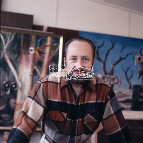
Audio - Audio Compact Cassette Tape, Audio Recording; Alan Marshall sitting for Joh Ebeli in his bungalow, Eltham 1977 with introduction by Joh Ebeli 2002, 1990s
... alan marshall, alan marshall bungalow, artists, audio cassette, audio recording, eltham, joh ebeli, sculptures...gold prospecting...smiths gully...Dubbed from original recording with introduction by Joh Ebeli 2002 General chit chat and banter between Joh Ebeli and Alan Marshall on various current affairs, matters of the past and artists and Joh's method of sculpture production. Topics include gold prospecting, Smith's Gully, Politician Jim Cairns, artists Neil Douglas and Pablo Picasso. ...Eltham District Historical Society Inc 728 Main Rd Eltham melbourne Dubbed from original recording with introduction by Joh Ebeli 2002 General chit chat and banter between Joh Ebeli and Alan Marshall on various current affairs, matters of the past and artists and Joh's method of sculpture production. Topics include gold prospecting, Smith's Gully, Politician Jim Cairns, artists Neil Douglas and Pablo Picasso. ...Dubbed from original recording with introduction by Joh Ebeli 2002 General chit chat and banter between Joh Ebeli and Alan Marshall on various current affairs, matters of the past and artists and Joh's method of sculpture production. Topics include gold prospecting, Smith's Gully, Politician Jim Cairns, artists Neil Douglas and Pablo Picasso. See also EDHS_00666 colour photo of Alan taken by Joh Ebeli and EDHS_02441 photo of plaster cast modelCompact audio cassette TDK D60 IEC I/Type I Converted to MP3 file; 33.8MB, 0:32:19 Case labelled "Alan Marshall talks while Joh Ebeli is sculpting his face in #1977 - in his bungalow in Eltham"alan marshall, alan marshall bungalow, artists, audio cassette, audio recording, eltham, joh ebeli, sculptures, gold prospecting, smiths gully, sculpting -
![Document, The Upper Yarra District; Victoria and its metropolis : past and present / by Alexander Sutherland ; R. L. J. Ellery ...[et.al.], pp411-415](/media/collectors/4f729f7b97f83e03086018a5/items/5e54ab1321ea6913785210e5/item-media/5e54abdc21ea691378544069/item-fit-380x285.jpg?cb=6) Eltham District Historical Society Inc
Eltham District Historical Society IncDocument, The Upper Yarra District; Victoria and its metropolis : past and present / by Alexander Sutherland ; R. L. J. Ellery ...[et.al.], pp411-415
... gully...george payne...george rae...george robert white...george stebbing...george thomas wiggin...gilbert marshall...Eltham District Historical Society Inc 728 Main Rd Eltham melbourne alan selman andrew paul anthony scott captain andrew wauchope charles le page charles mason christmas hills cornelius g. stewart daniel murphy david lithgow dennis rourk donald mcintyre donald mcrae dr william ronald duncan mcnab e kidgell edward moore poyner eltham ewan robertson fern tree gully george payne george rae george robert white george stebbing george thomas wiggin gilbert marshall h. perrin h.w. paul hazel glen healesville henry scarce snr isidore t. wilmot james john madden\ james keets james lindsay james mcpherson jnr james mcpherson snr james quigley james thomson james williamson john b john george maddicks john hicks petty john p lithgow john pulbrook snr john ryder john williamson joseph pett joseph stevenson kangaroo ground lilydale, michael mclaughlin michael supple morang mrs e. ronald mrs john mason mrs mary weller mrs murphy narrewarren nelson andrew patrick woulfe peter le page richard robert woolcott richard tamplin king ringwood riobert lum robert lithgow robert parry robert stevenson st hubert's thomas mcintyre jnr thomas mcintyre snr thomas moses thomas payne thomas quale thomas sherwin thomas younger upper yarra, walter wippell wandin yalloak whittlesea william kennedy ross william laidley william lalor william sebira william towt wilson yan yean yarra flats yering 5 x A4 pages photocopy extract of book The Upper Yarra District; Victoria and its metropolis : past and present / by Alexander Sutherland ; R. ...5 x A4 pages photocopy extract of book alan selman, andrew paul, anthony scott, captain andrew wauchope, charles le page, charles mason, christmas hills, cornelius g. stewart, daniel murphy, david lithgow, dennis rourk, donald mcintyre, donald mcrae, dr william ronald, duncan mcnab, e kidgell, edward moore poyner, eltham, ewan robertson, fern tree gully, george payne, george rae, george robert white, george stebbing, george thomas wiggin, gilbert marshall, h. perrin, h.w. paul, hazel glen, healesville, henry scarce snr, isidore t. wilmot, james john madden\, james keets, james lindsay, james mcpherson jnr, james mcpherson snr, james quigley, james thomson, james williamson, john b, john george maddicks, john hicks petty, john p lithgow, john pulbrook snr, john ryder, john williamson, joseph pett, joseph stevenson, kangaroo ground, lilydale, michael mclaughlin, michael supple, morang, mrs e. ronald, mrs john mason, mrs mary weller, mrs murphy, narrewarren, nelson andrew, patrick woulfe, peter le page, richard robert woolcott, richard tamplin king, ringwood, riobert lum, robert lithgow, robert parry, robert stevenson, st hubert's, thomas mcintyre jnr, thomas mcintyre snr, thomas moses, thomas payne, thomas quale, thomas sherwin, thomas younger, upper yarra, walter wippell, wandin yalloak, whittlesea, william kennedy ross, william laidley, william lalor, william sebira, william towt, wilson, yan yean, yarra flats, yering