
Showing 56 items matching "mcleod road"
-
 Sunshine and District Historical Society Incorporated
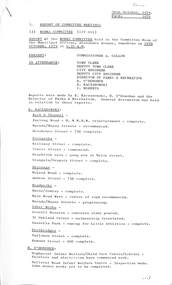
Administrative record - City of Sunshine - Commissioner Mr Alexander Alex George Gillon Collection 1976 - 1982 - Report of Committee Meetings 30th October 1979, City of Sunshine, 30th October 1979
... ...McLeod Road...Report of Committee Meetings 30th October 1979 Report of the Works Committee Meeting Kerb & Channel Furlong Road Sunshine North Reinstatement Completed Kerb & Channel Mernda Street & Mayne Street Sunshine West Recommenced Kerb & Channel Holehouse Street Sunshine North 75% Complete Footpath Kellaway Street Maidstone Completed Footpath Yewers Street Sunshine Commence Footpath Braybrook Area Gang now in Melon Street Footpath Glengala Road / Gregory Street Completed Drainage McLeod Road St. Albans Completed Drainage Andrew Street Sunshine Completed Roadwork Burns Street / Sonley Street Completed Roadwork Main Road West St. ...Furlong Road Sunshine North Mernda Street Mayne Street Sunshine West Holehouse Street Kellaway Street Yewers Street Melon Street Braybrook Glengala Road Gregory Street McLeod Road St. Albans Andrew Street Burns Street Sonley Street Maidstone Main Road West Scovell Reserve Scovell Crescent Oakland Street Maribyrnong Deer Park Little Athletics Centre Sassella Park Deer Park Station Road Yallourn Street Esmond Street Ardeer Highpoint West Infant Welfare Child Care Centre Highpoint West Library Rosamond Road Ballarat Road Infant Welfare Centre Report of Committee Meetings 30th October 1979 Report of the Works Committee Meeting Kerb & Channel Furlong Road Sunshine North Reinstatement Completed Kerb & Channel Mernda Street & Mayne Street Sunshine West Recommenced Kerb & Channel Holehouse Street Sunshine North 75% Complete Footpath Kellaway Street Maidstone Completed Footpath Yewers Street Sunshine Commence Footpath Braybrook Area Gang now in Melon Street Footpath Glengala Road / Gregory Street Completed Drainage McLeod Road St. ...Report of Committee Meetings 30th October 1979 Report of the Works Committee Meeting Kerb & Channel Furlong Road Sunshine North Reinstatement Completed Kerb & Channel Mernda Street & Mayne Street Sunshine West Recommenced Kerb & Channel Holehouse Street Sunshine North 75% Complete Footpath Kellaway Street Maidstone Completed Footpath Yewers Street Sunshine Commence Footpath Braybrook Area Gang now in Melon Street Footpath Glengala Road / Gregory Street Completed Drainage McLeod Road St. Albans Completed Drainage Andrew Street Sunshine Completed Roadwork Burns Street / Sonley Street Completed Roadwork Main Road West St. Albans Centre of Road Recommenced Roadwork Mernda Street & Mayne Street Sunshine West Progressing Other Work Scovell Reserve Concrete Slab Poured Other Work 31 Oakland Street Naturestrip Reinstated Other Work Sassella Park Run up for Deer Park Little Athletics Centre Completed Footbridge Yallourn Street Completed Footbridge Esmond Street 90% Complete Highpoint West Infant Welfare Child Care Centre Painting and Electrical Work Commenced Highpoint West Library Painting and Electrical Work Commenced Ballarat Road Infant Welfare Centre Inspection Completed Some Minor Works Outstanding Depot Amenities Block Work Nearing Completion Public Toilets Deer Park Letter of Approval Received from Health Department Tree Maintenance Talmage Street Albion Progressing Report of the Finance Committee Meeting Report of the Town Clerk Outstanding Rates Estimates 1979/80 Sunshine View Estate Stage 2 Drainage Report of the City Engineer & Planner Staff Reclassifications Rates, Sanitary & Interest Statement as at 30th September 1979 Rates, Sanitary & Interest Statement as at 30th September 1979 Analysis of Accounts Outstanding Rates, Sanitary & Interest Statement as at 30th September 1979 Progressive Analysis Accounts Outstandingfurlong road, sunshine north, mernda street, mayne street, sunshine west, holehouse street, kellaway street, yewers street, melon street, braybrook, glengala road, gregory street, mcleod road, st. albans, andrew street, burns street, sonley street, maidstone, main road west, scovell reserve, scovell crescent, oakland street, maribyrnong, deer park little athletics centre, sassella park, deer park, station road, yallourn street, esmond street, ardeer, highpoint west infant welfare child care centre, highpoint west library, rosamond road, ballarat road infant welfare centre -
 Sunshine and District Historical Society Incorporated
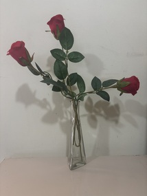
Decorative object - Australian Bosniak And Herzegovina Association Glass Flower Vase
... ...John McLeod Pavilion...Ballarat Road...This glass flower vase was found the in women's toilets of The Australian Bosniak And Herzegovina Association Club rooms located at the John McLeod Pavilion, Ballarat Road, Deer Park. The vase was found during a site inspection of the pavilion, just prior it being demolished in February 2026....This glass flower vase was found the in women's toilets of The Australian Bosniak And Herzegovina Association Club rooms located at the John McLeod Pavilion, Ballarat Road, Deer Park. The vase was found during a site inspection of the pavilion, just prior it being demolished in February 2026. ...This glass flower vase was found the in women's toilets of The Australian Bosniak And Herzegovina Association Club rooms located at the John McLeod Pavilion, Ballarat Road, Deer Park. The vase was found during a site inspection of the pavilion, just prior it being demolished in February 2026.The Australian Bosniak And Herzegovina Association was a community group located in Deer Park Victoria.Triangle shaped glass flower vase with plastic rosesaustralian bosniak and herzegovina association, john mcleod reserve, john mcleod pavilion, ballarat road, deer park -
 Sunshine and District Historical Society Incorporated
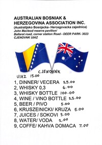
Archive - Australian Bosniak And Herzegovina Association Drink List
... ...John McLeod Pavilion...Ballarat Road...The Australian Bosniak and Herzegovina Association was using the John McLeod Pavilion, Ballarat Road, Deer Park as their club rooms. ...(Australijsko Bosnjacka - Hercegovacka zajednica John Mcleod Reserve Pavilion Ballarat Road Corner Station Road Deer Park 3023 Cjenovnk Uiaz...The Australian Bosniak and Herzegovina Association was using the John McLeod Pavilion, Ballarat Road, Deer Park as their club rooms. ...The Australian Bosniak and Herzegovina Association was using the John McLeod Pavilion, Ballarat Road, Deer Park as their club rooms. The association had moved out of the pavilion, and this drink menu price list was found during a site inspection of the pavilion just prior it being demolished in February 2026.The Australian Bosniak And Herzegovina Association was a community group located in Deer Park Victoria.Australian Bosniak & Herzegovina Association Inc. (Australijsko Bosnjacka - Hercegovacka zajednica John Mcleod Reserve Pavilion Ballarat Road Corner Station Road Deer Park 3023 Cjenovnk Uiazaustralian bosniak and herzegovina association, john mcleod reserve, john mcleod pavilion, ballarat road, deer park -
 Glen Eira Historical Society
Document - Malonga
... Road... McLeod Mrs...Keillerin James Dandenong Road McLeod Mrs Document Malonga ...Typed notes on the Thompson family, supplied by Sue Samuel, undated, also giving a brief history of the construction of Malonga, Dandenong Road, Caulfield. Also included are handwrittem research notes, undated and unattributed, listing the previous owners of Malonga rangingfrom its construction in 1891/1892 to 1939.samuel sue, grosmont, caulfield north, thompson walter, malonga, kooyong road, wallace elizabeth, dundee marmalade, jameson william, thompson elizabeth, ogilive john captain., mcleod james. a., keillerin james, dandenong road, mcleod mrs -
 Sunshine and District Historical Society Incorporated
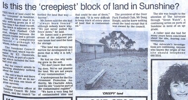
Archive - Deer Park Oval The Creepist Block Of Land In Sunshine
... John McLeod Reserve...Ballarat Road...In 2026, the club rooms have gone, the fence has gone and the land is still vacant however grass and trees are now growing on the block. John McLeod Reserve Ballarat Road Deer Park Deer Park Oval 7002.01 - Deer Park Oval The Creepist Block Of Land In Sunshine - The Advocate 19th June 1991 Page 7.jpg 7002.02 - John McLeod Reserve 2026 7002.03 - John McLeod Reserve 2026 7002.04 - John McLeod Reserve 2026 Ditigal Photographs Archive Deer Park Oval The Creepist Block Of Land In Sunshine ...This article was published by The Advocate on the 19th June 1991 as part of its regular feature "Street Watch". This block of land was once one of the creepiest blocks of land in Sunshine (Deer Park). Nobody knows why nothing grows on it or how long the land has stood vacant. The block is adjacent to the Deer Park Football Club oval, wedge between the players rooms and a private house. It is completely fenced, although by whom, nobody knows. The Sunshine Council owns the land. which was donated by ICI Chemicals as part of a package which included the football oval site, but the Council admits to knowing absolutely nothing about the land. The soil is black and there is no sign of life on its surface. Not even one blade of grass survives. In 2026, the club rooms have gone, the fence has gone and the land is still vacant however grass and trees are now growing on the block.7002.01 - Deer Park Oval The Creepist Block Of Land In Sunshine - The Advocate 19th June 1991 Page 7.jpg 7002.02 - John McLeod Reserve 2026 7002.03 - John McLeod Reserve 2026 7002.04 - John McLeod Reserve 2026john mcleod reserve, ballarat road, deer park, deer park oval -
 Sunshine and District Historical Society Incorporated
Administrative record - City of Sunshine - Commissioner Mr Alexander Alex George Gillon Collection 1976 - 1982 - Notice of committee meetings 11th February 1980, City of Sunshine, 6th February 1980
... ...John McLeod Reserve...Ballarat Road...ICI Oval Deer Park Oval John McLeod Reserve Ballarat Road Robert Bruce Reserve Station Road Deer Park Tallintyre Reserve Kermeen Street Sunshine West McKechnie Street Reserve Mckechnie Street St. ...Proposals for sporting pavilions and improvements ICI Oval Robert Bruce Reserve Tallintyre Reserve Ralph Street Reserve and McKenchnie Street Reserveici oval, deer park oval, john mcleod reserve, ballarat road, robert bruce reserve, station road, deer park, tallintyre reserve, kermeen street, sunshine west, mckechnie street reserve, mckechnie street, st. albans, ralph street reserve -
 Sunshine and District Historical Society Incorporated
Administrative record - City of Sunshine - Commissioner Mr Alexander Alex George Gillon Collection 1976 - 1982 - Report of committee meetings 18th September 1980, City of Sunshine, 30th September 1980
... Road...Sunshine North...Deer Park Lions Club...Maidstone Primary School...Scovell Reserve...Scovell Crescent...Maidstone...ICI Oval...John McLeod...Sunshine High School Ballarat Road Sunshine North Deer Park Lions Club Maidstone Primary School Scovell Reserve Scovell Crescent Maidstone ICI Oval John McLeod Reserve Station Road South Road Braybrook Main Road East St. ...Sunshine High School Deer Park Lions Club Maidstone Primary School Neotec Pty Ltd Repairs to cricket practice pitch Scovell Reserve ICI Oval Development Bon Thomas Reserve sprinklers Acquisition of Property 88 Station Road Removal of house South Road Intersection Beautification Main Road East and St. Albans Road Sunshine Swimming and Life Saving Clubsunshine high school, ballarat road, sunshine north, deer park lions club, maidstone primary school, scovell reserve, scovell crescent, maidstone, ici oval, john mcleod reserve, station road, south road, braybrook, main road east, st. albans road, st. albans, sunshine swimming and life saving club -
 Sunshine and District Historical Society Incorporated
Administrative record - City of Sunshine - Commissioner Mr Alexander Alex George Gillon Collection 1976 - 1982 - 1982 - Recommendations from forward planning meeting 13th November 1980, City of Sunshine, 9th December 1980
... ...John McLeod Reserve...Ballarat Road...ICI Oval John McLeod Reserve Ballarat Road Deer Park ICI Oval (John McLeod Reserve) Local Government Advisory Board Hearing on Ward Boundaries Foolscap sized document. ...ICI Oval (John McLeod Reserve) Local Government Advisory Board Hearing on Ward Boundariesici oval, john mcleod reserve, ballarat road, deer park -
 Sunshine and District Historical Society Incorporated
Administrative record - City of Sunshine - Commissioner Mr Alexander Alex George Gillon Collection 1976 - 1982 - Report of committee meetings 11th December 1980, City of Sunshine, 13th January 1981
... ...John McLeod Reserve...Ballarat Road...Maidstone Tennis Club Thomson Street Maidstone Sunshine Croquet Club Albanvale Pre-School Wright Street Bridge Wright Dtreet Sunshine Sunshine West Housing Commission ICI Oval John McLeod Reserve Ballarat Road Deer Park Bon Thomas Reserve Quinn Street Maidstone Primary School Curtin Crescent Hargraves Crescent Braybrook Tallintyre Reserve Kermeen Street Glengala Park Primary School Mailey Street Bradley Street Sunshine North Larissa Reserve Larissa Road St. ...Thomson Street Hall request for maintenance by Maidstone Tennis Club Sunshine Croquet Club offer for payment for recent works Albanvale Pre-School lack of kindergarten teachers Wright Street Bridge anticipated increase in traffic in local area Housing Commission Discussions ICI Oval and Bon Thomas Oval works Nature Strips Maidstone Primary School 1 Hargraves Crescent poor state of property Playground Equipment Tallintyre Reserve Street Signs Glengala Park Primary School Ombudsman 25 Bradley Street Fencing Larissa Reserve Unit 7 12 - 14 Drummartin Street Dangerous Building 6 Station Place Sunshinemaidstone tennis club, thomson street, maidstone, sunshine croquet club, albanvale pre-school, wright street bridge, wright dtreet, sunshine, sunshine west, housing commission, ici oval, john mcleod reserve, ballarat road, deer park, bon thomas reserve, quinn street, maidstone primary school, curtin crescent, hargraves crescent, braybrook, tallintyre reserve, kermeen street, glengala park primary school, mailey street, bradley street, sunshine north, larissa reserve, larissa road, st. albans, drummartin street, albion, station place -
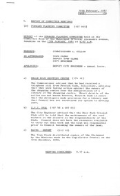 Sunshine and District Historical Society Incorporated
Administrative record - City of Sunshine - Commissioner Mr Alexander Alex George Gillon Collection 1976 - 1982 - Report of committee meetings 13th January 1981, City of Sunshine, 10th February 1981
... Road...Deer Park...ICI Oval...John McLeod...Neale Road Deer Park ICI Oval John McLeod Reserve Ballarat Road Sunshine Golf Club Station Place Sunshine Sunshine Jaycees Devonshire Road Selwyn Park Sunshine United Cricket Club Selwyn Street Albion Ralph Street Reserve Ralph Street Sunshine West Main Road East St. ...Neale Road Shopping Centre ICI Oval Sunshine Golf Club Dwelling Station Place partly destroyed by fire Sunshine Jaycees Adventure Playground Devonshire Road Selwyn Park use by Sunshine United Cricket Club Ralph Street Reserve inadequate water supply Development Railway Land Corner Main Road East and St. Albans Road Dempster Park Committee of Management and Cross Roads Football Club Dangerous Building at 6 Station Place Sunshineneale road, deer park, ici oval, john mcleod reserve, ballarat road, sunshine golf club, station place, sunshine, sunshine jaycees, devonshire road, selwyn park, sunshine united cricket club, selwyn street, albion, ralph street reserve, ralph street, sunshine west, main road east, st. albans road, st. albans, dempster park committee of management, cross roads football club, dempster park, phoenix street, sunshine north -
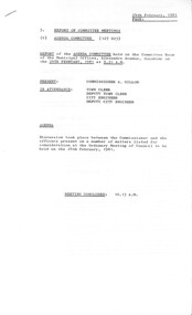 Sunshine and District Historical Society Incorporated
Administrative record - City of Sunshine - Commissioner Mr Alexander Alex George Gillon Collection 1976 - 1982 - Report of committee meetings 24th February 1981, City of Sunshine, 24th February 1981
... Road...Tottenham...ICI Oval...John McLeod...Albans Frederick Road Tottenham ICI Oval John McLeod Reserve Ballarat Road Anderson Road Sunshine Sunshine Football Club YMCW University of Melbourne George Street Talmage Street Albion Sunshine United Cricket Club Selwyn Park Selwyn Street Hargreaves Crecent Maidstone Tennis Club Sunshine Mens Hockey Club Skinner Reserve electrical works Deer Park Hall roof repairs and internal painting Sassella Park request from Sunshine Mens Hockey Club to use ground for 1981 hockey season Maidstone Tennis Club court weeding Sports Oval request from Sunshine Heights Junior to use D. ...Skinner Reserve electrical works Deer Park Hall roof repairs and internal painting Sassella Park request from Sunshine Mens Hockey Club to use ground for 1981 hockey season Maidstone Tennis Club court weeding Sports Oval request from Sunshine Heights Junior to use D. G. Wilson Oval at the Sunshine West High School Traffic Hazards Fairbairn Road St. Albans Tennis Club request for funds for a synthetic surface on two courts Flats Talmage Street roof damaged by baseballs Road Closure George Street Land Purchase University of Melbourne from ICI Hargreaves Crecent nature strip condition Crossing Desmond Street Sunshine United Cricket Club letter regarding the use of Selwyn Park by soccer players St. Albans Roatry Club advising their derise to initiate a BMX Track in St. Albans North Pigion Club request to use shed at Errington Reserve Right of Way Sydney Street Stead Industries Frederick Road ICI Oval poor condition Anderson Road Diversion Drain Sunshine Football Club is not paying its power accounts YMCW prepared to invest more money into Kinder Smith Reserve Naming of Ward Boundariesskinner reserve, churchill avenue, braybrook, kinder smith reserve, lily street, deer park hall, sassella park, station road, deer park, d. g. wilson oval, sunshine west high school, lachlan road, fairbairn road, sunshine west, st. albans tennis club, north pigion club, errington reserve, main road east, st. albans, frederick road, tottenham, ici oval, john mcleod reserve, ballarat road, anderson road, sunshine, sunshine football club, ymcw, university of melbourne, george street, talmage street, albion, sunshine united cricket club, selwyn park, selwyn street, hargreaves crecent, maidstone tennis club, sunshine mens hockey club -
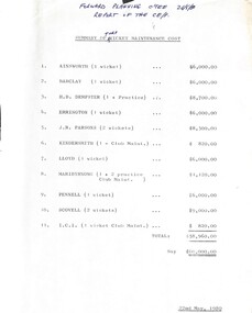 Sunshine and District Historical Society Incorporated
Administrative record - City of Sunshine - Commissioner Mr Alexander Alex George Gillon Collection 1976 - 1982 - Summary Of Turf Wicket Maintenance Cost 1980, City of Sunshine, 22nd May 1980
... Road East...St. Albans...Parsons Reserve...Stanford Street...Sunshine...Kindersmith Reserve...Lily Street...Braybrook...Lloyd Reserve...Camperdown Avenue...Maribyrnong Reserve...Hortense Street...Maribyrnong...Pennell Reserve...Burke Street...Scovell Reserve...Scovell Crescent...Maidstone...ICI Ground...Deer Park Oval...John McLeod...Road East St. Albans Parsons Reserve Stanford Street Sunshine Kindersmith Reserve Lily Street Braybrook Lloyd Reserve Camperdown Avenue Maribyrnong Reserve Hortense Street Maribyrnong Pennell Reserve Burke Street Scovell Reserve Scovell Crescent Maidstone ICI Ground Deer Park Oval John McLeod Reserve Ballarat Road Deer Park Summary of Turf Wicket Maintenance Cost Ainsworth Reserve Barclay Reserve H. ...Summary of Turf Wicket Maintenance Cost Ainsworth Reserve Barclay Reserve H. B. Dempster Reserve Errington Reserve J. R. Parsons Reserve Kindersmith Reserve Lloyd Reserve Maribyrnong Reserve Pennell Reserve Scovell Reserve ICI Ground (Deer Park Reserve now John McLeod Reserve)ainsworth reserve, vernon crescent, barclay reserve, king edward avenue, albion, dempster reserve, phoenix street, sunshine north, errington reserve, main road east, st. albans, parsons reserve, stanford street, sunshine, kindersmith reserve, lily street, braybrook, lloyd reserve, camperdown avenue, maribyrnong reserve, hortense street, maribyrnong, pennell reserve, burke street, scovell reserve, scovell crescent, maidstone, ici ground, deer park oval, john mcleod reserve, ballarat road, deer park -
Surrey Hills Historical Society Collection
Programme - Ephemera, Chatham Primary School Fathers' Club 'Trial by Jury' programme, 16/11/1929
... Mr M Walker (donor's father) not found in electoral roll for 1931; thought to have lived in Sir Garnet Road. Mr McLeod - a number listed in the 1931 electoral roll. ...Mr M Walker (donor's father) not found in electoral roll for 1931; thought to have lived in Sir Garnet Road. Mr McLeod - a number listed in the 1931 electoral roll. ...The program describes the performance as 'original burlesque' and was written, composed and produced by A E Woffinden and A W Sutton, members of the Chatham Fathers' Club, to raise money for the school. There were 250 programs printed at a cost of one pound fifteen shillings. This performance starred 21 of the fathers with Mr W Crellin as the only female character, Miss Eileen Flapper. The Chatham Fathers' Club became renowned locally for the quality of its performances, repeats being given to other community organisations. In the publication 'Chatham Past & Present: A Patchwork of People' there is also a photo of the cast taken in the quadrangle of the school. The original program and photo were lent to the school at the time of the 70 year reunion in 1997 by Mrs Jean Lacy (nee Walker), whose father took part as a member of the jury. Many of the performers were also in the formal photo of the Father's Club, taken in February 1928 on the front steps of the school. The original hangs in the school entry foyer and is reproduced in 'A Patchwork of People: Chatham Past and Present'. In relation to names, these are better identified and the following identifications have been reached by referencing this and the 1931 electoral roll. The geographic spread of addresses reflects that when Chatham opened in August 1927, surrounding schools were overcrowded and some families chose to relocate their children. Albert Ernest Woffinden (manufacturer) lived at 14 Banool Road, Surrey Hills. Alfred William Sutton (clerk) lived at 528 Whitehorse Road, Surrey Hills. Mr A Davidson - not found in electoral roll. Walter Dallas Kinross (mechanic) lived at 72 Empress Road, Surrey Hills. Gilbert Leslie (Bert) Rae (sales) lived at 63 Empress Road, Surrey Hills. Mr Joseph P Braddick (mechanic) lived at 1 Northcote Avenue, Canterbury; now Balwyn (NB/ Name is miss-spelt Braddock in the program). Norman Patrick Smart (bt opr) lived at 61 Sir Garnet Road, Surrey Hills. Henry Albert Wysham (show card writer) lived at 9 Northcote Avenue, Canterbury. Mr Sidney Bessant (labourer) lived at 191 Mont Albert Road, Canterbury. William Morrison (teacher) lived at 37 Chatham Road, Canterbury. William Charles Crellin (breadcarter) lived at 59 Empress Road, Surrey Hills. Mr F Parsons - taken as Fred Parsons (bricklayer) lived at 2 Kaarumba Grove, Balwyn. Mr MacDougal (incorrectly spelt in program) is Dougall MacDougall (gas collector) lived at 5 Wells Street, Surrey Hills. Mr A V Webb - not found. Mr McKie - not found. Victor Harold Theodore Clow (civil servant) lived at 4 Talbot Avenue, Balwyn; listed as T. Clow. Mr M Walker (donor's father) not found in electoral roll for 1931; thought to have lived in Sir Garnet Road. Mr McLeod - a number listed in the 1931 electoral roll. Richard Frost (carriage builder) lived at 341 Mont Albert Road, Surrey Hills. Mr Allen - a number listed in the 1931 electoral roll. Mr J Tulloch - not found in the 1931 electoral roll. This is an example of 'home-spun' entertainment and creativity of the era when the sense of community was very real. It is an example of the fundraising efforts undertaken by school communities to provide 'extras' that would later be regarded as 'basics'. For many years the sense of community in this part of Surrey Hills revolved around Chatham school, the Benson Street Methodist Church and the football club, located at the Canterbury Recreation Ground.A photocopy of the programme for the Chatham Primary School Fathers' Club "Trial by Jury" performance on 16 November 1929. It includes the words of the song 'Carry me back to dear old Chatham'. It lists the performers by character and some details regarding the Chatham Primary School Fathers' Club.chatham primary school, chatham primary school fathers' club, theatrical productions, entertainment, albert ernest woffinden, fundraising, alfred william sutton, walter dallas kinross, gilbert leslie (bert) rae, joseph p braddick, norman patrick smart, henry albert wysham, sidney bessant, william morrison, william charles crellin, fred parsons, dougall macdougall, mr a v webb, mr mckie, victor harold theodore clow, mr m walker, mr mcleod, richard frost, mr allen, mr j tulloch -
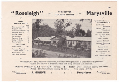 Marysville & District Historical Society
Ephemera (item) - Accommodation booklet advertisement, Broadbent's Official Road Guides Company, "Roseleigh" Marysville, Unknown
... An advertisement for Roseleigh guest house in Marysville which was taken from a Broadbent's accommodation guide. marysville victoria australia roseleigh guest house grieve family thomas charles grieve john arthur grieve rose grieve ackerman family mary moyne elise ackerman ken mcleod george peters rose emily pullum beltana rose lillian smith ivy may grieve alexander james ficinus raymond charles smith advertisement accommodation broadbent's accommodation guide An advertisement for Roseleigh guest house in Marysville which was taken from a Broadbent's accommodation guide. "Roseleigh" Marysville Ephemera Accommodation booklet advertisement Broadbent's Official Road ...An advertisement for Roseleigh guest house in Marysville which was taken from a Broadbent's accommodation guide.An advertisement for Roseleigh guest house in Marysville which was taken from a Broadbent's accommodation guide.marysville, victoria, australia, roseleigh guest house, grieve family, thomas charles grieve, john arthur grieve, rose grieve, ackerman family, mary moyne, elise ackerman, ken mcleod, george peters, rose emily pullum, beltana, rose lillian smith, ivy may grieve, alexander james ficinus, raymond charles smith, advertisement, accommodation, broadbent's accommodation guide -
 Flagstaff Hill Maritime Museum and Village
Vehicle - Wagon, H.H. Smith & Co. Baker, Circa 1930s - 1940s
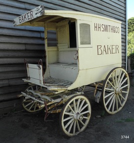
... road race committee...national trust building...stan lake...bill lake...ali dean...19th and 20th century bakers...davies steam biscuit factory warrnambool...james mcleod...Smith Street Warrnambool was named after Henry Huntington Smith, who was a Warrnambool Councillor 1913 – 1937 and Mayor 1919 – 1921. warrnambool shipwrecked-coast flagstaff-hill flagstaff-hill-maritime-museum maritime-museum shipwreck-coast flagstaff-hill-maritime-village shipwrecked-artefact great ocean road baker’s wagon h.h. smith baker, warrnambool henry h smith jeannie samson-goodman frank crossley mayor of city of warrnambool vice president of warrnambool and district historical society stephenson’s bakery warrnambool harold stephenson warrnambool surf life saving club road race committee national trust building stan lake bill lake ali dean 19th and 20th century bakers davies steam biscuit factory warrnambool james mcleod building designer jobbins and mcleod william cust h h smith & co, pastry cooks and confectioners bakery trade bread delivery wagon Brown signwriting on sides of wagon “H.R. ...This baker’s wagon or cart transported and delivered bread and other baked goods in the Warrnambool area. It currently has advertising for H.H. Smith & Co. Henry Huntington Smith (1857-1941) owned and operated his Warrnambool bakery in the late 19th and early 20th century. However, the design of the wagon is similar to those used by local bakers in the 1930s and 1940s and probably originated from Stephenson’s Bakery in Warrnambool, which operated around that time. The wagon’s original internal shelves were removed in the early days of Flagstaff Hill so that children could have rides around the village in a horse-driven cart. BAKERS’ HISTORY There were many bakeries in Warrnambool in the 19th to mid-20th century. Each bread bakery made horse and cart deliveries in its allocated zone. SMITH’S BAKERY; – as shown on the wagon’s signage. Henry Huntington Smith (1857-1941) was born and educated in Warrnambool. He worked at Davis’ steam biscuit factory in Timor Street before he began his own bakery business in 1885 near the corner of Fairy and Koroit Streets. A few years later Smith built a new bakery on the corner of Fairy and Lava Street where it still stands today (2025) as Monaghan’s Pharmacy. The building was designed by James McLeod in 1892 as a bakehouse, shop and residence for Smith The address was known locally as Smith’s Corner. Next door to the bakery, at 136 Fairy Street, were stables built by Jobbins and McLeod in 1886 for William Cust. A photograph in the archives of the Warrnambool and District Historical Society shows the 1892 building with four fancy horse-drawn wagons on the street with white-clad drivers and a promotional stand erected with 5 bakers in uniform and the signage “H H Smith & Co, Pastry Cooks and Confectioners”. One of the wagons appears to have “H H Smith” painted on the side. H.H. Smith & Co. placed an Advertisement in the Weekly Times in December 1896 promoting its business as bakers, confectioners and pastry cooks, praising their shop as an ‘ornament to the town’ with ‘neat appointments’ and ‘dainty decorations’. It also boasted of supplying a large number of customers within a twelve-mile radius of Warrnambool. In November 1919 The Warrnambool Standard announced the marriage of Henry H Smith, Mayor of Warrnambool, to Jeannie Samson-Goodman in East Adelaide. In the same newspaper was a notice that Frank Crossley was to open as baker and pastry cook in H.H. Smith’s premises. As well as being the proprietor of the H.H. Smith Bakery, Henry Huntington Smith was a Councillor for the Warrnambool Municipality from 1913 to 1937 and Mayer for two terms. In December 1919 during his first term as Mayor, he was honoured for the work he had done with returning soldiers after World War I, receiving a document in recognition of this work, presented by the Mothers, Wives and Sisters of returned soldiers. Smith was very interested and involved in the community in many roles, including being the Vice President of the first Warrnambool and District Historical Society. STEPHENSON’S BAKERY: – believed to be the past owner of the wagon. The last owner of the bakery was Harold Stephenson. Stephenson was enlisted in the A.I.F. and was invalided home in 1943 before the end of the Second World War. He also served as a Councillor from 1958 to 1976, during which time he served six terms as Mayor for the City of Warrnambool (1966-1973) while he had the bakery. He was very involved in many local organisations including the Warrnambool Surf Life Saving Club and the Road Race Committee. He died in 1985, lauded as being one of Warrnambool’s “most distinguished civic leaders”. It has been said that the baker injured in World War II invented a special contraption to enable him to get up into the wagon and that he alerted his customers that he was in their vicinity by blowing a whistle. The customers would come out and choose their bread from the back of his wagon then pay him for it. However, another account is given by a man who once earned pocket money by helping the baker on his rounds. He says that it was Stephenson, the owner and manager of the bakery, and not the delivery baker who received a significant injury during the war, making him unable to climb the stairs of his upstairs accommodation at the bakery, therefore causing him to sleep downstairs. At this time in the early to late 1940 Stephenson’s bakery had three wagons, one for each of the delivery rounds. The wagons were painted black and yellow. Two of the drivers were Stan Lake and Ali (Alec) Dean who both had wagons with the covered cabin design. The third driver was Bill Lake who had a flat wagon. Stan Lake delivered in the area around Lava and Koroit Streets, Ali Dean had another round and Bill Lake had the Dennington area. Bread continued to be delivered into the 1960s but by this time the delivery vehicles were motorised. The goods produced at Stephenson’s bakery included bread baked in different shaped tins such as High Tin, Sandwich and Vienna. Some shapes were easily divided into half by breaking them apart, therefore the baker could make two-quarter loaves from a half loaf, satisfying different needs. There was the option of white or brown bread, sweet buns, fruit buns and Boston buns. The baker’s assistant was known to take great delight in ‘trimming’ the broken halves of excess bread and crust, enjoying his treat. THE BAKERY PREMISES: – Southeast corner of Fairy and Lava Streets, Warrnambool. The building retains the original cast iron veranda. Above the veranda, a motif of a wheat sheaf in ornamental plaster can be seen. Inside the building, there are still some of the original fittings. The building was classified by the National Trust in August 1979. After the Second World War, an official system of zoning was introduced as a fair way for the baking industry to operate. In 1949 different pricing was introduced by the Government for either delivered or retail purchased bread. Many of the small local bakeries went out of business after the Government banned zoning. The way was made open for the larger bread manufacturers to enter the local market with cheaper prices. Some of those companies were Mc Queens, Tip Top, Twisties, and Sunicrust, (Mc Queens ‘new’ bakery building was where the current Toyworld shop now stands, is, in the Ozone carpark.) O’Grady’s Bakery, later changing hands and known as Burkes Bakery, was on Fairy Street near the Timor Street intersection, on the North West side. There was also a bakery named Almay. The baker’s wagon is significant because of its association with H.H. Smith’s Bakery in Warrnambool.. The H.H. Smith’s Bakery building on the corner of Fairy and Lava Streets, built in 1892, is classified by the National Trust, August 1979. Smith Street Warrnambool was named after Henry Huntington Smith, who was a Warrnambool Councillor 1913 – 1937 and Mayor 1919 – 1921. Baker’s wagon, often referred to as a baker’s cart. Four wheeled horse-drawn delivery wagon, front wheels smaller than rear wheels. Wagon is clad with metal sheets and lined with varnished timber panels. Wheels have metal rims, wooden spokes and rear wheels have wooden brake pads. Horse shaft is timber with metal fittings. Front has a metal lamp holder, brake lever, metal hand grips and decorative metal foot plates. The wagon has suspension leaves on back and sides and double suspension leaves on the front. Driver’s area at front has a roof, glass side windows and wooden box seat with hinged compartment accessing wagon storage area. Door above back of seat has buckled leather handgrip strap attached, door slides open for access to wagon area. Back of wagon has a wooden step and a split door; top door has ventilation louvers, both doors have metal latches. Wagon is painted cream with brown trim and signage and green step. Remnants of red and green paint are visible; underside of seat panel is painted grey. Wagon advertises H.H. Smith & Co. Baker, a Warrnambool business established in 1885, but is of a more modern design seen around 1930’s and 1940’s and most likely belonging to Stephenson's bakery. Brown signwriting on sides of wagon “H.R. SMITH & CO. / BAKER” Brown signwriting across front of wagon “BAKER” warrnambool, shipwrecked-coast, flagstaff-hill, flagstaff-hill-maritime-museum, maritime-museum, shipwreck-coast, flagstaff-hill-maritime-village, shipwrecked-artefact, great ocean road, baker’s wagon, h.h. smith baker, warrnambool, henry h smith, jeannie samson-goodman, frank crossley, mayor of city of warrnambool, vice president of warrnambool and district historical society, stephenson’s bakery warrnambool, harold stephenson, warrnambool surf life saving club, road race committee, national trust building, stan lake, bill lake, ali dean, 19th and 20th century bakers, davies steam biscuit factory warrnambool, james mcleod building designer, jobbins and mcleod, william cust, h h smith & co, pastry cooks and confectioners, bakery trade, bread delivery wagon -
 Orbost & District Historical Society
black and white photograph, 1897
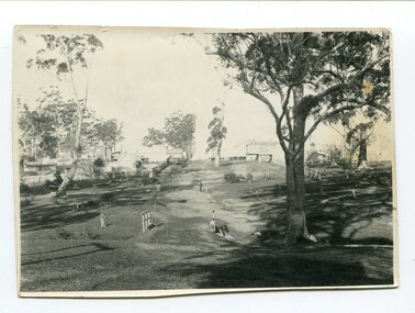
... This is a pictorial record of the Orbost township in the late 19th century. orbost-township mcleod-street-orbost A black / white photograph of a street scene. The road is unsealed and there are several wooden buildings. ...This photograph has been taken looking up McLeod Street, Orbost from the present farmers' store towards the Club Hotel in 1897.This is a pictorial record of the Orbost township in the late 19th century.A black / white photograph of a street scene. The road is unsealed and there are several wooden buildings. A man can be seen on the left side.orbost-township mcleod-street-orbost -
 Orbost & District Historical Society
black and white photograph, early 20th century
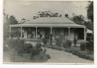
... McLeods in 1870. (more info. July 2006 Newsletter) When Sir William died the property was owned by his son, Rupert who offered the land for sale at 4 pounds per acre. No sale resulted and the property was leased for a few years until in 1898 it was subdivided and sold to many of Orbost's first families. (info. from In Times Gone By- Deborah Hall) This house was located on the western side of Forest Road...McLeods in 1870. (more info. July 2006 Newsletter) When Sir William died the property was owned by his son, Rupert who offered the land for sale at 4 pounds per acre. No sale resulted and the property was leased for a few years until in 1898 it was subdivided and sold to many of Orbost's first families. (info. from In Times Gone By- Deborah Hall) This house was located on the western side of Forest Road ...The McLeods, were the original holders of the Orbost station. Sir William Clarke bought the station from McLeod Bros. Sir William was a very fine man and noted for his philanthropic actions. He finally cut up and sold the Orbost station and presented 10 acres of land to the people of Orbost for a show and recreation ground. Sir William Clarke had taken over the Orbost run from the McLeods in 1870. (more info. July 2006 Newsletter) When Sir William died the property was owned by his son, Rupert who offered the land for sale at 4 pounds per acre. No sale resulted and the property was leased for a few years until in 1898 it was subdivided and sold to many of Orbost's first families. (info. from In Times Gone By- Deborah Hall) This house was located on the western side of Forest Road. Orbost.This is a pictorial record of one of the first residences in Orbost.A black/ white photograph of a large wooden house. It has a verandah at the front and sides. There are three children two girls and a boy - standing on the verandah to the left of the door. The house is surrounded by gardens.on front - Orbost Home Stationorbost-station clarke-william clarke-rupert -
 Ringwood and District Historical Society
Photograph, Official opening of Heathmont Infant Welfare Centre, 30th November 1960. Mrs L McLeod, Mrs E Baxter, Lady Brooks, Mayor Horman
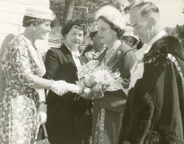
... McLeod, Mrs E Baxter, Lady Brooks, Mayor Horman (left to right). All material is from Gwen Horman’s three albums that she owned. Some photos have been taken by Peter Payens of Ringwood Studios, 36 Whitehorse Road, Ringwood, WU-7609, probably for the Ringwood mail newspaper. ...McLeod, Mrs E Baxter, Lady Brooks, Mayor Horman (left to right). All material is from Gwen Horman’s three albums that she owned. Some photos have been taken by Peter Payens of Ringwood Studios, 36 Whitehorse Road, Ringwood, WU-7609, probably for the Ringwood mail newspaper. ...Official opening of Heathmont Infant Welfare Centre, 30th November, 1960. Mrs L McLeod, Mrs E Baxter, Lady Brooks, Mayor Horman (left to right). All material is from Gwen Horman’s three albums that she owned. Some photos have been taken by Peter Payens of Ringwood Studios, 36 Whitehorse Road, Ringwood, WU-7609, probably for the Ringwood mail newspaper. -
 Orbost & District Historical Society
poster, 1898
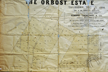
... McLeods in 1870. When Sir William died the property was owned by his son, Rupert who offered the land for sale at 4 pounds per acre. No sale resulted and the property was leased for a few years until in 1898 it was subdivided and sold to many of Orbost's first families. (info. from In Times Gone By- Deborah Hall) This is an important reminder of the very early history of the settlement of Orbost. orbost-station clarke-sir-william orbost-estate A rectangular paper poster for the sale of the Orbost Estate on Forest Road, Orbost. ...This poster was made for the sale of the 1,440 acres of Orbost Station after the death of Sir William Clarke. It was sold by Edward Trenchard & Co. which was the oldest Stock and Station agent in Victoria assisted by Desailly, Macarthur & Co were livestock experts. Sir William Clarke had taken over the Orbost run from the McLeods in 1870. When Sir William died the property was owned by his son, Rupert who offered the land for sale at 4 pounds per acre. No sale resulted and the property was leased for a few years until in 1898 it was subdivided and sold to many of Orbost's first families. (info. from In Times Gone By- Deborah Hall)This is an important reminder of the very early history of the settlement of Orbost.A rectangular paper poster for the sale of the Orbost Estate on Forest Road, Orbost. It is dated "Thursday Dec 1898" and was made for the sale of the 1,440 acres of Orbost Station after the death of Sir William Clarke. The poster gives written details of the sale and a plan of the property.orbost-station clarke-sir-william orbost-estate -
 Phillip Island and District Historical Society Inc.
Photograph Album, Kodak, Phillip Island Cemetery, c 1889
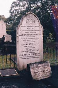
... road and is surrounded by Manna Gums, rare Peppermint Gums, Blackwoods and other native trees. In all 25 acres of land were set aside as Crown Land in the land settlement of 1868. There are 6.2 acres of wetlands near the cemetery entrance. Phillip Island Cemetery Captain Alexander McLeod ...The Album was compiled by Nancy McHaffie late 1990's, with the assistance of Edith Jeffery's, with her book "Garden of Memories" and extensive knowledge of Phillip Island. The Cemetery lies back from the road and is surrounded by Manna Gums, rare Peppermint Gums, Blackwoods and other native trees. In all 25 acres of land were set aside as Crown Land in the land settlement of 1868. There are 6.2 acres of wetlands near the cemetery entrance.Captain McLeod: Captain McLeod and family kept the Post Office at Newhaven. He also built a boat called old "Trusty" and launched it almost opposite Churchill Island. Unfortunately, at a later date, the "Trusty" was the cause of a tragedy. The bottom of the boat had become so encrusted with marine growth that the owner decided to beach her between the jetties at Griffiths point, now San Remo. Before the job was completed the soring gave way and allowed the boat to tip over on her side, causing Captain McLeod to be crushed to death. Died March 3rd 1880 aged 64 years. Also buried in this grave is his wife Susan - died May 24th 1882 aged 62 years. Their son Andrew McLeod died February 21st 1916 aged 60 - loved husband of Elizabeth E McLeod. Alexander was Captain of the "Genista" for 12 years.phillip island cemetery, captain alexander mcleod, susan mcleod, andrew mcleod, nancy mchaffie, edith jeffery -
 Orbost & District Historical Society
May 1900
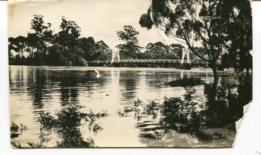
... McLeod, with whom the first settlement of this district is generally associated, took up their residence on the eastern bank of the Snowy River about the year 1841 or 42. The late Mr W. Roadknight and Mr T. T. Stirling took possession of the territory on the western side of the Snowy about 35 years ago. During the occupation of the country by cattle owners, very little progress was made in the way of roads...McLeod, with whom the first settlement of this district is generally associated, took up their residence on the eastern bank of the Snowy River about the year 1841 or 42. The late Mr W. Roadknight and Mr T. T. Stirling took possession of the territory on the western side of the Snowy about 35 years ago. During the occupation of the country by cattle owners, very little progress was made in the way of roads ...This is a photograph of the original Orbost / Snowy River Bridge , a suspension bridge which opened in 1893. It has been taken when the Snowy River was in flood. It is similar to other photographs held in The State Library, Victoria. The Snowy River Mail and Tambo and Croajingolong Gazette Sat 12 Aug 1893 records the opening of this bridge as "the most important public event that has yet been commemorated in Eastern ......The Messrs McLeod, with whom the first settlement of this district is generally associated, took up their residence on the eastern bank of the Snowy River about the year 1841 or 42. The late Mr W. Roadknight and Mr T. T. Stirling took possession of the territory on the western side of the Snowy about 35 years ago. During the occupation of the country by cattle owners, very little progress was made in the way of roads and bridges, and except to the hardy and lexperienced bushman, it might have been generally regarded as inaccessible. About the year 1877, however, the late Mr James Robertson eldest son of Mr James Robertson, of Lochend farm, selected land now occupied by his father, about four miles from Orbost on the west bank of the river, Mr John Cameron visited the. district shortly after a .tour of inspection and returned later with his brothers, James and Alick Gameron, but found that during their absence Mr Ernest Watt had found his way on the scene and pegged out a selection, thus anticipating the advent of the Camerons by about 12 hours. We understand that a Mr Kidd, who selected the property now occupied by Mr W. J. Ross, at Pumpkin Point, was one of the earliest batch of settlors.........."This is a pictorial record of an early bridge across the Snowy River at Orbost.A black / white photograph of a suspension bridge with flood waters below the bridge.orbost-bridge suspension-bridge snowy-river -
 Orbost & District Historical Society
black and photograph / postcard, 1.4.1908
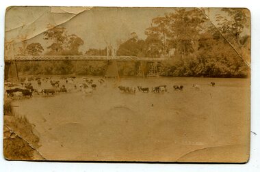
... McLeod, with whom the first settlement of this district is generally associated, took up their residence on the eastern bank of the Snowy River about the year 1841 or 42. The late Mr W. Roadknight and Mr T. T. Stirling took possession of the territory on the western side of the Snowy about 35 years ago. During the occupation of the country by cattle owners, very little progress was made in the way of roads...McLeod, with whom the first settlement of this district is generally associated, took up their residence on the eastern bank of the Snowy River about the year 1841 or 42. The late Mr W. Roadknight and Mr T. T. Stirling took possession of the territory on the western side of the Snowy about 35 years ago. During the occupation of the country by cattle owners, very little progress was made in the way of roads ...This postcard was sent to Annie Gilbert (Mrs John Gilbert) of Tullagoota, Orbost. It was written by "Grace", probably her sister, Grace Cameron Annie Gilbert was the daughter of John Cameron who selected the first land on the Snowy River flats. This is a photograph of the original Orbost / Snowy River Bridge , a suspension bridge which opened in 1893. It has been taken when the Snowy River was in flood. It is similar to other photographs held in The State Library, Victoria. The Snowy River Mail and Tambo and Croajingolong Gazette Sat 12 Aug 1893 records the opening of this bridge as "the most important public event that has yet been commemorated in Eastern ......The Messrs McLeod, with whom the first settlement of this district is generally associated, took up their residence on the eastern bank of the Snowy River about the year 1841 or 42. The late Mr W. Roadknight and Mr T. T. Stirling took possession of the territory on the western side of the Snowy about 35 years ago. During the occupation of the country by cattle owners, very little progress was made in the way of roads and bridges, and except to the hardy and lexperienced bushman, it might have been generally regarded as inaccessible. About the year 1877, however, the late Mr James Robertson eldest son of Mr James Robertson, of Lochend farm, selected land now occupied by his father, about four miles from Orbost on the west bank of the river, Mr John Cameron visited the. district shortly after a .tour of inspection and returned later with his brothers, James and Alick Gameron, but found that during their absence Mr Ernest Watt had found his way on the scene and pegged out a selection, thus anticipating the advent of the Camerons by about 12 hours. We understand that a Mr Kidd, who selected the property now occupied by Mr W. J. Ross, at Pumpkin Point, was one of the earliest batch of settlers.........."This item is associated with Annie Gilbert (nee Cameron) reported to have been the first white girl to be born in Orbost. It is a pictorial record of the suspension bridge over the Snowy River which has since been replaced twice.A faded black / white postcard of a bridge across a river. There are cattle in the river and the banks are tree-covered.on back - a hand-written letter addressed to Mrs J. Gilbert Tullagoota Orbost.cameron-annie suspension-bridge-orbost snowy-river-orbost -
 Eltham District Historical Society Inc
Photograph - Black and White Print, Janet Hubbard, Former Cobb & Co. Staging Post, Christmas Hills, 1965
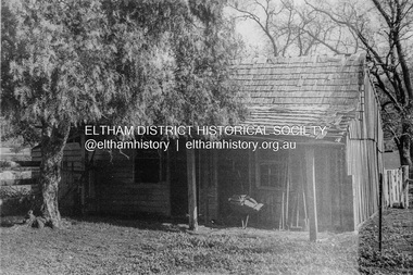
... Road, Christmas Hills. On this property was an old timber building with timber shingled roof, which had been a Cobb and Co staging post. Janet made a sketch of this building and also took a photo at the time. The property was owned at the time by a person named McLeod...Road, Christmas Hills. On this property was an old timber building with timber shingled roof, which had been a Cobb and Co staging post. Janet made a sketch of this building and also took a photo at the time. The property was owned at the time by a person named McLeod ...In 1965 Janet Hubbard worked on a children’s holiday farm called Ponyland in Osbourne Road, Christmas Hills. On this property was an old timber building with timber shingled roof, which had been a Cobb and Co staging post. Janet made a sketch of this building and also took a photo at the time. The property was owned at the time by a person named McLeod who later demolished the old building. '6958' processing stamp on reverse of photo Texta line drawing of chook on reverse of sketchchristmas hills, cobb and co, osbourne road, ponyland, staging post -
Glen Eira Historical Society
Plan - Nettalie
... Road... Ford W... Lempriere... Cople J... Riddell J C... Manifold J... Testar T... Billing R H... Semple... Blundell... Shaw A... Butchart G... Stephen J W... Stephen G Sir... Hart J... Duncan G... Blackie R... Stephen F... McCombie T... Woollaston H... Higgins J... Lloyd J C... Daish J... McLeod...Caulfield Caulfield North Elsternwick St Kilda East Parish of Prahran Parish of Moorabbin Caulfield Road District Melbourne and Brighton Railway Rosstown Railway Elsternwick Railway Station Caulfield Railway Station Rosstown Railway Station Murrumbeena Railway Station Baptist Church Paddy’s Swamp reserve Cemetery Reserve Leman Swamp Reserve Caulfield Racecourse Reserve Brighton Cemetery The Vine Caulfield Hotel The Tam O’Shanter Hotel Melbourne Hunt Hotel Royal Hotel Hotham Street Horne Street Nepean Highway North Road Orrong Road Dandenong Road Princes Highway Kooyong Road Alma Road Inkerman Road Balaclava Road Glen Eira Road Glen Huntly Road Hawthorn Road Cemetery Road Bambra Road Redan Road Kambrook Road Neerim Road Booran Road Racecourse Road Grange Road Koornang Road Murrumbeena Road Crosbie Road Kangaroo Road Poath Road Ford W Lempriere Cople J Riddell J C Manifold J Testar T Billing R H Semple Blundell Shaw A Butchart G Stephen J W Stephen G Sir Hart J Duncan G Blackie R Stephen F McCombie T Woollaston H Higgins J Lloyd J C Daish J McLeod J Hughes D Wilson A Jamieson G Webb G H Renwick S Pennington H Dunn J Kirkpatrick W Ricketson W Toad A Sayce J Watts T Widgery Store Guess J Anketell J Clack J Sissen W Clayton G Dickson D Bevan J Hart T Anderson J Hart Mrs Webb H Masters S Waghorn J Hemming C Hiam C Farquhar W Newing T Payne T Cooper R Snipe S Chambers J Forster W Summers R Harriman B Warrick O’Connell Long J Peck R Cochrane C Murray Ross W Evans C Kennedy J Maclean N Forster Lyall W Dean J Newton H Looker W Baker C Johnston Crosbie J Kerr Jones Parr Nelson C Montgomery L Parsons W James J C Sibon C Smith Sydney W Plans Maps Land subdivisions Land use Settlements Roads and streets Hotels Churches Police stations Post offices Land surveys Railway stations Railways Schoolhouses Commerce Clergy residences Official buildings Local government Road districts Plan Nettalie ...An A4 photocopy of the 'Plan of the Caulfield Road District' dated 1867. This plan shows the location of the properties owned by A Shaw and Blundell on Balaclava and Orrong Roads where Nettalie is situated. The plan includes all the landowners listed where their property was, the street names and other landmarks of 1867 including railways, hotels and reserves.caulfield, caulfield north, elsternwick, st kilda east, parish of prahran, parish of moorabbin, caulfield road district, melbourne and brighton railway, rosstown railway, elsternwick railway station, caulfield railway station, rosstown railway station, murrumbeena railway station, baptist church, paddy’s swamp reserve, cemetery reserve, leman swamp reserve, caulfield racecourse reserve, brighton cemetery, the vine caulfield hotel, the tam o’shanter hotel, melbourne hunt hotel, royal hotel, hotham street, horne street, nepean highway, north road, orrong road, dandenong road, princes highway, kooyong road, alma road, inkerman road, balaclava road, glen eira road, glen huntly road, hawthorn road, cemetery road, bambra road, redan road, kambrook road, neerim road, booran road, racecourse road, grange road, koornang road, murrumbeena road, crosbie road, kangaroo road, poath road, ford w, lempriere, cople j, riddell j c, manifold j, testar t, billing r h, semple, blundell, shaw a, butchart g, stephen j w, stephen g sir, hart j, duncan g, blackie r, stephen f, mccombie t, woollaston h, higgins j, lloyd j c, daish j, mcleod j, hughes d, wilson a, jamieson g, webb g h, renwick s, pennington h, dunn j, kirkpatrick w, ricketson w, toad a, sayce j, watts t, widgery, store, guess j, anketell j, clack j, sissen w, clayton g, dickson d, bevan j, hart t, anderson j, hart mrs, webb h, masters s, waghorn j, hemming c, hiam c, farquhar w, newing t, payne t, cooper r, snipe s, chambers j, forster w, summers r, harriman b, warrick, o’connell, long j, peck r, cochrane c, murray ross w, evans c, kennedy j, maclean n, forster, lyall w, dean j, newton h, looker w, baker c, johnston, crosbie j, kerr, jones, parr, nelson c, montgomery l, parsons w, james j c, sibon c, smith sydney w, plans, maps, land subdivisions, land use, settlements, roads and streets, hotels, churches, police stations, post offices, land surveys, railway stations, railways, schoolhouses, commerce, clergy residences, official buildings, local government, road districts -
 Warrnambool and District Historical Society Inc.
Book, A Ton of Class: 100 favourite recipes from the families and friends of Allansford and District Primary School, 2014
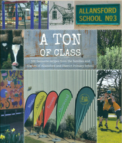
... Roads Board. In an attempt to recoup some of the heavy losses due to the disastrous Bateman fire of 1854 John subdivided a portion of Tooram at the Hopkins River crossing known as Allans ford. A school reserve was included in this subdivision. Source: McLeod...Roads Board. In an attempt to recoup some of the heavy losses due to the disastrous Bateman fire of 1854 John subdivided a portion of Tooram at the Hopkins River crossing known as Allans ford. A school reserve was included in this subdivision. Source: McLeod ...This cookery book was produced in 2014 as a school fundraiser. It was purchased at Allansford Cheese World in January 2015 for $15. Allansford school was established as a National School in 1856 on land reserved for the purpose by John McMahon Allan. It comprised two sandstone classrooms -one for boys and one for girls -with an attached pise teacher's residence. In 1872 when the Victorian Education Department was set up existing schools were listed in alphabetical order and given a number. Allansford State School was No.3. The school was enlarged in the late 1800s and again in the early 1920s. In 1994 following the amalgamation of the Allansford, Allans Forest and Naringal schools a new school was built which adjoined the existing buildings. The old buildings were refurbished as administration and staff facilities. John McMahon Allan settled in the area in 1839 with his brother William Osborne Allan. They were the sons of David Allan, Deputy Commissary General during Macquarie's term of government. The brothers divided the station with William retaining the Allandale portion and John naming his portion Tooram. John McMahon Allan was president of the early district Roads Board. In an attempt to recoup some of the heavy losses due to the disastrous Bateman fire of 1854 John subdivided a portion of Tooram at the Hopkins River crossing known as Allans ford. A school reserve was included in this subdivision. Source: McLeod, Graeme & Barbara. Allansford 1855-2006This book has social and historical interest and significance as it is connected to a local school. It provides a snapshot of food and cooking methods in the early 21st cebturyCookery book with full colour cover featuring 8 photographs and drawings of the Allansford Primary School surrounds and pupil activities. The images are 'stitched' together with a white zig-zag diamond pattern as if a quilt. The foldout cover has an image of the school's centenary memorial gates and a brief history of the school. Inside the foldout are images of the pupils in each of the school's four team houses. The foldout back cover has full colour images of pupils performing at the school concert. A white strip noting 'our values' is included on the inside back cover foldout. Soft cover, 112 pages.allansford school, a ton of class, allansford primary school, a ton of class recipe book -
4th/19th Prince of Wales's Light Horse Regiment Unit History Room
Order of Ceremony, The Royal Australian Amored (sic) Corps the Keeffe Family & Eoghan McDonald Celebrates (sic) the Unveiling of a Commemorative Plaque 16 November 2014, 2014
... At 0400 hrs, C Squadron's vehicles reached O'Sullivan's Paddock on the Kobyboyn Road; prior to reaching the Old Telegraph Road the column turned to the North towards a known crossing point on Whiteheads Creek. The column consisted of seven M3 Medium Tanks and four Universal Carriers. In the case of Corporal McLeod's...At 0400 hrs, C Squadron's vehicles reached O'Sullivan's Paddock on the Kobyboyn Road; prior to reaching the Old Telegraph Road the column turned to the North towards a known crossing point on Whiteheads Creek. The column consisted of seven M3 Medium Tanks and four Universal Carriers. In the case of Corporal McLeod's ...The 13th Australian Armoured Regiment was a Gippsland militia unit that had been called up for full time duty in December 1941 as a traditional light horse regiment. The early months of 1942 had seen the regiment lose its horses, a conversion to a motor regiment and finally to an armoured regiment in May. During this period there were considerable changes in personnel, however the regiment maintained its strong links to Gippsland and its former identity. Between May and November 1942, individual soldiers had become proficient in their trade training and the regiment changed its focus to troop and squadron activities. On 16 November 1942, the unit was located at the Puckapunyal Army Camp. C Squadron's training program involved a night driving exercise where a column of armoured and B vehicles would depart camp at 0245 hours and proceed to a site to the East of Seymour and set up a bivouac between Whiteheads Creek and Highlands Road. Numerous army camps surrounded the Seymour area; and much of the surrounding farm land had been acquired for military purposes. By November 1942 exercises such as C Squadron's were commonplace and had been repeated on numerous occasions since 1939. At 0400 hrs, C Squadron's vehicles reached O'Sullivan's Paddock on the Kobyboyn Road; prior to reaching the Old Telegraph Road the column turned to the North towards a known crossing point on Whiteheads Creek. The column consisted of seven M3 Medium Tanks and four Universal Carriers. In the case of Corporal McLeod's vehicle, there were seven crewmen rather than the usual five man crew. On arrival at the creek crossing, Captain C.M.I. 'Sandy' Pearson dismounted and with the assistance of Sergeant R.J. Ball began to guide individual tanks across the creek. Four tanks had crossed the creek without difficulty when Corporal McLeod's tank, ARN 24652, began its descent. Captain Pearson stated at the Coroner's Inquiry in December 1942, "Whilst climbing out of the ford the vehicle swerved to the left, apparently striking the tree. It was not the portion of the tank (front) that struck the tree. The tank straightened and appeared to be well under control, suddenly the bank on the left collapsed to the extent of 3ft by 12ft by15ft long causing the vehicle to slide into the creek and turn upside down." Captain Pearson and Sergeant Ball were faced with a nightmarish situation: The Grant had come to rest upside down in soft mud, six crew members were unaccounted for, escape hatches could not be opened and the weight of the tank was settling deeper into the water and mud. Compounding the problem was that the location of the tank did not allow for the other tanks to safely conduct a recovery. It was truly the darkest night.Single A4 card. folded, Contains an account of the raising of 13 Armoured Regiment in December 1941and a tank accident during a night creek crossing in which six crewmen were killed, and, Order of Ceremony for plaque unveiling, Guest of Honour LtCol Stuart Cree CO/CI School of Armour13 armored regiment, tank accident, puckapunyal -
 Eltham District Historical Society Inc
Photograph, Montmorency Tennis Club, c.1941, 1941c
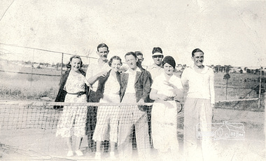
... In the 1943 Electoral Roll they were recorded living at Watson St, McLeod and in 1949 at Mt. View Road, Montmorency. (Information gathered from Ancestry.com sources). ...In the 1943 Electoral Roll they were recorded living at Watson St, McLeod and in 1949 at Mt. View Road, Montmorency. (Information gathered from Ancestry.com sources). ...Thomas John Kent (b. 1/9/18, d. 13/3/1998) married Florence Janet Hughes (b. 5/1/1921, d. 24/3/2011) on 15/11/1941. In the 1943 Electoral Roll they were recorded living at Watson St, McLeod and in 1949 at Mt. View Road, Montmorency. (Information gathered from Ancestry.com sources). Based on this data, the date of this photograph is estimated to be c. 1941 not 1927 as originally noted, which was the date that the Montmorency Tennis Club was established.Black & white photograph of eight individuals from Montmorency Tennis Club including Jack and Florrie Kent, c.1941"Montmorency Tennis Club c.1927 Jack Kent Florrie Kenttennis club, jack kent, montmorency, florrie kent -
Glen Eira Historical Society
Document - LECHTE, WILLIAM LUDWIG SAMUEL SEBASTION
... Road... Tom Roe’s Market Garden... McLeod...Tom Healey’s Market Garden Kooyong road Inkerman Road Tom Roe’s Market Garden McLeod Captain Daish Captain Plumridger Mr. ...3 items about this person: 1/Two twelve page carbon copied documents, purportedly written by William Letchte, son of George, written in c1935/36. He writes of his jobs as a dairyman, cow minder at the age of ten tears. He recollects streets, people, residences, business and general landscape in the area, as he takes you on a tour of the area. 2/Photocopied photo of Katrina Lechte (nee Bolch?) donated by Ian Lechte, 15 Adrian Street, East Bentleigh. 3/Photocopied copy of first pages and cover of William Lechte’s booklet on ‘Caulfield 1869 – 1935 Memories of the Past’, published by the City of Caulfield, 1992. The Society has the full booklet in its book collection (not yet catalogued as of 07/07/2015).grange road, glenhuntly, glen huntly station, alma road, dairies, caulfield park, swamp, queens avenue, station street, cross street, racecourse, heywood j. g., turf club hotel, dandenong road, royal hotel, koornang road, north road, murrumbeena road, mclaurin archibald, crosbie j. w., poath road, newton mr., hooker mr., peck family robert farmer, dairies, ross murray, rosstown, hansen hans, arnott family, peppin family, ormond station, malane family, fraser simon, overtons, shepherds, spring road, mohlers, brighton cemetery, mall kim, market gardeners, long john farmer, fiedler mr., booran road, reservoir, summers mr., maddocks mr., holland mr., caulfield council, glen eira road, harriman benjamin c., kambrook road, bambra road, princess park, marriott john, hawthorn road, brickworks, hyam mr., cottages, jasmine street, sycamore street, paddy o’briens swamp, arnold tom, london tavern hotel, guess john-grocer, topp mr., poath road, pine trees, colonel le marehand, balaclava junction, chemist shop, bell mr., nicholls mr. william h., wine shop, orme mr., pepperorn mr. john, balaclava road, orchards, harvey mr. robert tailor, schubert mr., blew charlie – gardener, philpott mr. richard b., farquhar mr. william farmer, newing t. r., glen eira road, payne john, brockhoft mr., dickson mr. james, snipe t., bevan mr., mckean family john, murray family, francis mr., hart mr., mcdougall james, brady peter, cad, elsternwick station, webb mr., masters mr. samuel, master street, ford mr., anderson mr. joseph gardener, slaney mr., boxhill mr. richard, post office, newsagent, hotham street, service james, bunn mr., sargood mr., orrong road, arnold tom – dairy, officer mr., grimwade mr., alexandra street, oakleigh hall, degraves mr., wilson samuel, ‘manifold’, house names, miller septimus, alma road, knox mr. james gardener, smith mr., coachman, ‘cumloden’, lange mr., holyrood justice mr., cronin mrs. mary, mcgivenys dairy, ‘belle vista’, lloyd c. d., caulfield council, hughes mr., armstrong j. a., tom healey’s market garden, kooyong road, inkerman road, tom roe’s market garden, mcleod captain, daish captain, plumridger mr. frederick, gardeners, tester mr. thomas, kent mr., kent g., fiddes mr., billings mr., semple mr., fosberry mr., howitt or., merrett mr., orchards, hawthorn road, hines mr., ‘rosecraddock’, langdon h. j., ‘crotonhurst’, webb justice mr., renwick s., ‘garrell’, barry mr., drinsdale family, st. mary’s church, sunday school, newing miss, teachers, stephen justice mr., stephen wilberforce, mount l., grimwade’s, ‘grimwade house’, danby’s, spence mr., venables family, mr. moss’ congregational church, barnhill mrs., porter miss, webb’s, ferguson, orange, police stations, kooyong road, pennington mr., health inspectors, engineers, inkley mr., farriers, mckeon mr., ‘sylverly’, dixon mr. edward, turner mr., marriott robert, ‘ravenhurst’, thompson j. j., wott t., architects, perrin mr. francis, tennis courts, royal parade, sayce mr. joseph j. p., ricketson h., ‘glen eira’, mansions, hospitals, turner mr., evans family, stephens miss, registers, mcculloch lady, convalescent homes, prentice street, edward street, strickland, keany pat, brentwood charlie, fordham lewis, hopetoun gardens, higgins mr. joseph f. engineer, railway construction bill, evans mr., beavis mr., twycross family john, medina captain, cowderoy mr. benjamin, murray mr., moore mr., ‘glenfern’, st. georges road, glen huntly road, cedar street, hunt bill – ‘bandy hunt’, jessamine street, alder street, le page’s store, post offices, balaclava junction, stephens frank, solicitors, parkside street, robinson j., ilbery mr. and family, mclennan mrs., victoria street, savings bank, riddell parade, elworthy mr. richard, butchers, shaw mr. william, armstrong mr., guess’ hotel, sycamore street, bagshaw mr., clack joe, wawn alex, sisson family, north road, younger mr., kooyong road, sheridan joseph, anketell family – john, wren john – carpenter, wills mr. peter, attrills arnold, heffernan family, cox peter, ilbery john, hotham street, glen huntly road, page j. w., bakeries, forests, godfrey mr., blacksmiths, thompson j. j., olive street, cedar street, letchte w., tierney richard, alma road, st. kilda east, murray peter, letchte’ cows – grazing, holland grove, eskdale road, lechte katrina, lechte ian, lechte catherine, lechte warren, lechte stuart, lechte elaine -
Glen Eira Historical Society
Document - GLEN HUNTLY (HISTORY OF)
... Road... Hannan Lyn Mrs. (Urban Planning Officer)... Glen Huntly Shopping Centre... Sculptures... Street Beautification Scheme... “Flying the Yellow Flag”... Moore Olive... “Return to Rosstown”... Jowett D. F.... Weickhardt I. S.... “From Sand Swamp and Health”... Murray Peter R.... Wells John C.... Caulfield Historical Society... Newsletters... Place Names Committee... McLeod...McLeod, secretary of the Place Names Committee, to Mr. D. R. Aylen, CEO of the City of Caulfield, notifying the latter of the alteration of the name ‘Glenhuntly’ to ‘Glen Huntly’. Appendix B is a list of the ministers of St. David’s Uniting Church from its formation in 1916 to the present. Appendix C identifies the persons portrayed in St. David’s stained glass windows. Appendix D is a poster announcing the auction of 41 blocks of land between Hawthorn and Bambra Road...Road Hannan Lyn Mrs. (Urban Planning Officer) Glen Huntly Shopping Centre Sculptures Street Beautification Scheme “Flying the Yellow Flag” Moore Olive “Return to Rosstown” Jowett D. F. Weickhardt I. S. “From Sand Swamp and Health” Murray Peter R. Wells John C. Caulfield Historical Society Newsletters Place Names Committee McLeod ...This file contains one item: 1/A loose-leaf, 23-page document titled ‘The History of Glen Huntly’, by Alfred R. Jones, dated 20/06/1991, describing the history of the suburb. The author has drawn heavily from the 4 sources noted in the bibliography. Subjects covered include the ship the suburb is named after, the suburb’s State School, the suburb’s churches, the Rosstown Railway and Sugar Mill, the origin of the name of Carnegie, the suburb’s aerodrome, and the beautification of the Glen Huntly Shopping Centre. The final 12 pages consist of 9 appendices relating to the aforementioned subjects. Appendix A is a typewritten letter from Ron McLeod, secretary of the Place Names Committee, to Mr. D. R. Aylen, CEO of the City of Caulfield, notifying the latter of the alteration of the name ‘Glenhuntly’ to ‘Glen Huntly’. Appendix B is a list of the ministers of St. David’s Uniting Church from its formation in 1916 to the present. Appendix C identifies the persons portrayed in St. David’s stained glass windows. Appendix D is a poster announcing the auction of 41 blocks of land between Hawthorn and Bambra Road formerly owned by William Ross, plus a map identifying said land blocks and another for locality. Appendix E is an A4 plan of the Rosstown Railway. Appendix F is a drawing of the Rosstown Sugar Mill. Appendix G is a poem titled ‘The Swagman’s Retreat’, by Herb Arnott, about the failure of the Mill. Appendix H is a map of Caulfield’s horse tramways plus a list of opening and closing dates. Appendix J is a list of streets explaining the meanings of their names.glen huntly, glenhuntly, local history, ‘glen huntly’ (ship), ‘glen huntlely’ (ship), quarantine stations, glen huntly road, lake street, mernda avenue, glen huntly state school no. 3703, ormond francis, ormond, garden avenue, grange road, churches, congregational church, glen huntly presbyterian church, st. david’s, st. david’s uniting church, anglican church, jenkin william ‘boss’, methodist church, wattle avenue, smith a. w. mr., glen huntly post office, glen huntly road, king f. l. mr., uniting church, child care centre, presbyterian church of eastern australia, glen huntly methodist church, sun aria, miller mary, stained glass, phrenologists, trinity congregational church, primitive methodists, ‘the victorian independent’, mercy mr., greek orthodox original old calendar church, wanalta road, salvation army, halls, myrtle street, catholic church, st. anthony’s roman catholic church, foundation stones, neerim road, mannix archbishop, st. agnes’ anglican church, booran road, sunday schools, clergy residences, ‘see’ anglican news magazine, lees archbishop, booth archbishop, glen huntly presbyterian church, el nido grove, tennis courts, bollard v. w. right rev., waratah avenue, royal avenue, munster avenue, james street, rothschild street, peace memorial organ, singers, bremner marie, scotland betty, carden joan, rosstown railway, south caulfield, plants, marata road, curraweena road, bambra road, ross william murray, ross leila, ross constance, vautin constance, ‘the grange’, north road, leila road, wild cherry road, caulfield roads board, elsternwick, land sales, sugar mills, koornang road, woornack road, elsternwick railway station, riddell parade, clarence street, dover street, oakleigh road, murrumbeena crescent, carlisle crescent, railways, trains, parks and reserves, caulfield council, sussex street, caulfield city council, swamps, rosstown sugar mill, rosstown estate, ‘the swagman’s retreat’, arnott herb, rosstown, carnegie, ‘ross’s folly’, carnegie andrew, rosstown hotel, dandenong road, rosstown road, rosstown plate horse race, caulfield racecourses, ames avenue, rosstown court, hostels, murrumbeena, cinemas, innovations (cabinetry film), films, music, pianos, manchester grove, safeway store, squash courts, airports, lord reserve, aeroplanes, air navigation act 1921, neville street, larkin sopwith aviation company of australasia, lyons street, morgan street, bookmakers, nightsoil, poultry, weatherboard buildings, glen huntly railway station, rosedale avenue, rifle clubs, scout groups, 1st glen huntly troop, ana, dowding jack mr., glen huntly infant welfare and family planning clinic, vermador private hospital, watson grove, rowlands (drapers), bones plant nursery, caulfield railway station, bridges, trams, horse tramways, glen eira road, elsternwick railway station, kooyong road, aboriginal peoples, truganini road, hannan lyn mrs. (urban planning officer), glen huntly shopping centre, sculptures, street beautification scheme, “flying the yellow flag”, moore olive, “return to rosstown”, jowett d. f., weickhardt i. s., “from sand swamp and health”, murray peter r., wells john c., caulfield historical society, newsletters, place names committee, mcleod ron, aylen d. r. mr., jones hugh rev., king joseph, scarfe james, vertigan sidney, vertigan earle, rance victor, flavell cameron, denholm robin, moorhead ken, taliai siupeli, eccles james leslie, little agnes, hutchins william r., dickie may a., gordon ivey agnes, theobald a. a. mrs., brownbill lloyd norman, ash georgette, land sales, auctions, messrs. crews & arkle, street names -
Glen Eira Historical Society
Book - Chisholm Institute of Technology
... McLeod Ian... McKenry Keith... Chisholm Caroline... Jones B.O. Hon.... Coogan C. K. Dr.... Green K.D.... Aboriginal Medicine... Solar... Engineering... Applied Physics... Prospectus... Chisholm History... School of Art and Design... David Syme Business School... School of Education... School of Nursing... School of Social and Behavioural Studies... Faculty of Technology... Centre for Applied Mathematical Modelling... Centre for Business Technology... Centre for Industrial Tribology... Centre for Development of Entrepreneurs... Chisholm Timber Engineering Technology Centre... International Business Centre... Polymer Research Centre... Building Plans... Building Construction... Invitations... Caulfield Plaza... Princes Avenue... Railway Avenue... Queens Avenue... Caulfield Station... Derby Road...McLeod Ian McKenry Keith Chisholm Caroline Jones B.O. Hon. Coogan C. K. Dr. Green K.D. Aboriginal Medicine Solar Engineering Applied Physics Prospectus Chisholm History School of Art and Design David Syme Business School School of Education School of Nursing School of Social and Behavioural Studies Faculty of Technology Centre for Applied Mathematical Modelling Centre for Business Technology Centre for Industrial Tribology Centre for Development of Entrepreneurs Chisholm Timber Engineering Technology Centre International Business Centre Polymer Research Centre Building Plans Building Construction Invitations Caulfield Plaza Princes Avenue Railway Avenue Queens Avenue Caulfield Station Derby Road Caulfield East Dandenong Road Caulfield Chisholm Institute of Technology Caulfield Campus Frankston Campus Education Tertiary Education Book Chisholm Institute of Technology ...Chisholm Institute of Technology’s Faculty of Technology Magazine, Feedback, No.3 1989. 1988 Prospectus of Chisholm Institute of Technology Official Invitation to opening of Continuity and Change, dated November 1985. Chisholm Institute of Technology Planning Brief (draft copy) dated 1985. Includes architectural drafts of campus. Fourteen pages including Building Plans. Official invitation to staff and students’ exhibition at Chisholm Institute of Technology 1983. Chisholm Institute of Technology Conferring of Awards booklet dated May 20, 1983. Includes list of graduates, staff and council. With handwritten notes on rear end pages. Undated brochure of advertising courses offered at Chisholm Institute of Technology. Loose card inside with description At Chisholm You’ll Get More Than Just A Piece Of Paper. Includes campus plans. Chisholm Institute of Technology Open Day brochure dated 1982. Includes map at back.vaughan geoffrey n. dr., jakovidis greg, mcleod ian, mckenry keith, chisholm caroline, jones b.o. hon., coogan c. k. dr., green k.d., aboriginal medicine, solar, engineering, applied physics, prospectus, chisholm history, school of art and design, david syme business school, school of education, school of nursing, school of social and behavioural studies, faculty of technology, centre for applied mathematical modelling, centre for business technology, centre for industrial tribology, centre for development of entrepreneurs, chisholm timber engineering technology centre, international business centre, polymer research centre, building plans, building construction, invitations, caulfield plaza, princes avenue, railway avenue, queens avenue, caulfield station, derby road, caulfield east, dandenong road, caulfield, chisholm institute of technology, caulfield campus, frankston campus, education, tertiary education
