Showing 131 items matching "measuring tools"
-
 Moorabbin Air Museum
Pamphlet (Item) - Ansett The Tools Of Our Trade Measuring Tools
... Ansett The Tools Of Our Trade Measuring Tools...Ansett The Tools Of Our Trade Measuring Tools...Moorabbin Air Museum Moorabbin Airport 12 First Street Moorabbin melbourne Ansett The Tools Of Our Trade Measuring Tools Pamphlet Ansett The Tools Of Our Trade Measuring Tools ... -
 Kew Historical Society Inc
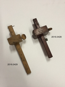
Tool - Measuring Tool, Marples of Sheffield, Wooden Marking Gauge, 1850-1950
... ...measuring tools...Wooden Marking Gauge Tool Measuring Tool Marples of Sheffield ...Marking Gauge. Manufactured by Marples of Sheffield, England. Also known as a scratch gauge, it is used in woodworking and metalworking to mark out lines for cutting or other operations. The purpose of the gauge is to scribe a line parallel to a reference edge or surface. The gauge consists of a beam, a headstock, and a scribing or marking implement, typically a pin, knife, pen or wheel. The headstock slides along the beam, and is locked in place by various means: a locking screw, cam lever, or a wedge.Maker's namemarking gauge, measuring tools, marples of sheffield -
 Kew Historical Society Inc
Tool - Measuring Tool, Stanley, Wooden Marking Gauge, 1900-1950
... ...measuring tools...Wooden Marking Gauge Tool Measuring Tool Stanley ...Marking gauge. Manufactured by Stanley. A marking gauge, also known as a scratch gauge, is used in woodworking and metalworking to mark out lines for cutting or other operations. The purpose of the gauge is to scribe a line parallel to a reference edge or surface. The gauge consists of a beam, a headstock, and a scribing or marking implement, typically a pin, knife, pen or wheel. The headstock slides along the beam, and is locked in place by various means: a locking screw, cam lever, or a wedge.Manufacturer's namemarking gauge, stanley -- tool manufacturer, measuring tools -
 Whitehorse Historical Society Inc.
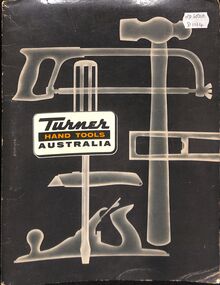
Book, Turner Australia Hand Tools, 1963
... Screwdrivers, planes, hammers, knives, spirit levels, hacksaws, measuring tapes, gardening tools, lawn mowers, with price list....Catalogue of hand tools - screwdrivers, planes, hammers, knives, spirit levels, hacksaws, measuring tapes, gardening tools, lawn mowers, with price list....Catalogue of hand tools - screwdrivers, planes, hammers, knives, spirit levels, hacksaws, measuring tapes, gardening tools, lawn mowers, with price list. ...Printed Catalogue of hand tools.Catalogue of hand tools - screwdrivers, planes, hammers, knives, spirit levels, hacksaws, measuring tapes, gardening tools, lawn mowers, with price list.Printed Catalogue of hand tools.turner industries, lawnmowers, tools -
 Mont De Lancey
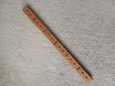
Carpenters Measures
... ...Measuring instruments...Carpentry tools...Mont De Lancey 71 Wellington Road Wandin North yarra-valley-and-dandenong-ranges Measures Measuring instruments Carpentry tools 2 Carpenters measures, both with 66 foot measure. a. ...2 Carpenters measures, both with 66 foot measure. a. Cloth measure in brass case. b. Metal measure in metal case.measures, measuring instruments, carpentry tools -
Moorabbin Air Museum
Manual - Aviation Technician Integrated Training Program, Aviation Technician Integrated Training Program General Section Books 1 through 7
... ...Hand tools & measuring devices...Moorabbin Air Museum Moorabbin Airport 12 First Street Moorabbin melbourne Aviation technician integrated training program Mathematics & Physics Basic electricity Aircraft drawings Weight & balance Fluid lines & fittings Aircraft hardware Hand tools & measuring devices Corrosion & its control Nondestructive inspection Ground handling & servicing General overview of aircraft maintenance, circa 1981 2 ring binder Aviation Technician Integrated Training Program General Section Books 1 through 7 Manual Aviation Technician Integrated Training Program. ...General overview of aircraft maintenance, circa 19812 ring bindernon-fictionGeneral overview of aircraft maintenance, circa 1981mathematics & physics, basic electricity, aircraft drawings, weight & balance, fluid lines & fittings, aircraft hardware, hand tools & measuring devices, corrosion & its control, nondestructive inspection, ground handling & servicing -
 Sunshine and District Historical Society Incorporated
Book - Accurate Tool Work, C.L. Goodrich et al, 1908
... It details historical methods for achieving extreme precision using traditional measuring tools and workshop practices....It details historical methods for achieving extreme precision using traditional measuring tools and workshop practices. machine shop practice machine-tools Accurate Tool Work Hard cover book. ...The book is a foundational text in manual machining and toolmaking. It details historical methods for achieving extreme precision using traditional measuring tools and workshop practices.Accurate Tool Workmachine shop practice, machine-tools -
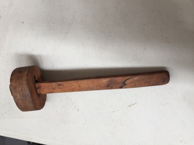 Kiewa Valley Historical Society
Woodworking Tool - Marking Guage
... A marking gauge is a measuring tool used in woodworking projects. It is ideal for marking out lines or scribing on various surfaces before sawing, chiseling, or cutting. ...A marking gauge is a measuring tool used in woodworking projects. It is ideal for marking out lines or scribing on various surfaces before sawing, chiseling, or cutting. ...Very old. Made of wood possibly beech wood.Used by carpenters and/or cabinet makers living in the Kiewa Valley.Wooden scribe - marking tool. A marking gauge is a measuring tool used in woodworking projects. It is ideal for marking out lines or scribing on various surfaces before sawing, chiseling, or cutting. Most models have a radius bottom edge ideal for sliding along the wood being marked, making it an easy tool to use.woodworkers tool, marking guage, wooden scribe -
 Vision Australia
Functional object - Object, Wooden ruler
... Made prior to 1971, when metric measurements were introduced, this 18-inch ruler is a demonstration of how easily a simple visual measuring tool could be adapted for varying degrees of sight by the use of tactile markings. ...Made prior to 1971, when metric measurements were introduced, this 18-inch ruler is a demonstration of how easily a simple visual measuring tool could be adapted for varying degrees of sight by the use of tactile markings. ...A wooden ruler with raised metal dots marking the spacings on the ruler. Made prior to 1971, when metric measurements were introduced, this 18-inch ruler is a demonstration of how easily a simple visual measuring tool could be adapted for varying degrees of sight by the use of tactile markings. 1 wooden ruler with metal pins as measurement pointsassistive devices, royal national institute for the blind -
 Flagstaff Hill Maritime Museum and Village
Tool - Hem marker stand, 1900s
... This hem marker stand is a measuring tool for gauging the height of a hem, such as on a dress or curtain. ...Flagstaff Hill Maritime Museum and Village 89 Merri Street Warrnambool great-ocean-road This hem marker stand is a measuring tool for gauging the height of a hem, such as on a dress or curtain. ...This hem marker stand is a measuring tool for gauging the height of a hem, such as on a dress or curtain. The adjustable arm slides along the ruler and its snug fit ensures that it stays at the right height. The end of the arm has a metal pin inserted into it to hold a piece of chalk, which would be used to mark the fabric. The hem marker would be used by professional dressmakers, seamstresses, and tailors as well as by crafts people at home. The hem marker was made in Birmingham.The hem marking stand is an example of tools used during the 1900s in the garments and furnishings trades as well as for domestic purposes. Since that time the tool has evolved into a more efficient design that makes home sewing easier.Ham marking stand with a wooden ruler, stand and a sliding adjustable arm on a brass sleeve. The arm has a metal pin on the end. Measurements are marked on both sides, inches on one side and centimetres on the other. Inscriptions are stamped into the wood. Made in Birmingham."- - - - / - - - - - / -BIRMINGHAM" On end of arm "2*4'flagstaff hill, warrnambool, maritime village, maritime museum, shipwreck coast, great ocean road, hem marker, dressmaker, dressmaking, alterations, tailor, dressmaker's tool, sewing marker, sewing gauge, seamstress, domestic use, dress fitting, curtain hemming, birmingham, freestanding, chalk hem marker, stand, home craft -
 Kiewa Valley Historical Society
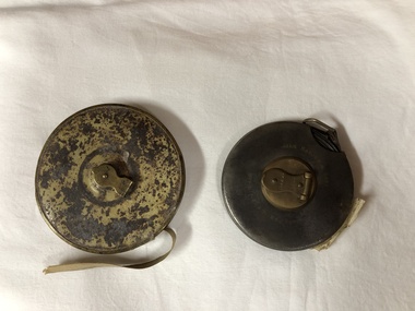
Tape Measure, mid 1900s
... wired tape measure...tool...This item was manufactured in England as, was the majority of measuring tool and equipment. It was not until the late 1950s that other countries e.g. ...This item was manufactured in England as, was the majority of measuring tool and equipment. It was not until the late 1950s that other countries e.g. ...This item predates the change of Imperial measure (England -1824) to decimal measure (Europe) in Australia (1970 to 1988). This item was manufactured in England as, was the majority of measuring tool and equipment. It was not until the late 1950s that other countries e.g. United States and Europe provided the same type of manufactured tools for the Australian market. World War II, when Australia had to defend its own boarders that the political push for self sufficiency of manufactured goods started local production. Workers in the Kiewa Valley had always relied on the high quality of tools and manufactured goods coming from England. From the middle to late 1950s migration by skilled workers from a war torn Europe provided the source of manpower for the expansion of the manufacturing industries in Australia.The requirement of an accurate measuring tool has always been critical. This item was used at the time when Australia was using the British Imperial measurements. Accurate measurements by carpenters and other trades people for both town and rural needs was just as critical as for the larger cities. The transition period from Imperial to metric was a period of over four years but it still presented those who had used the Imperial measurements for a longer period in their trades with a dual system of measurement for a longer time(usually up to their retirement) Other nations still using Imperial measurements kept the transition from Imperial to metric alive (the UK and USA still uses Imperial measurements in 2012)Retractable metallic wired tape measure within a leather casing. Length of tape is 66 feet. Brass fittings on casing(winder and back plate)Tape on one side marked in inches and feet and on the other in links. Winder lever marked "66ft No 401" on front and arrow with"wind this way". Leather cover marked "John R A Bone & Sons Birmingham England" on reverse side "Metallic wired tape R A Bone & Sons"wired tape measure, tool, mobile tool, construction tool -
 Creswick Campus Historical Collection - University of Melbourne
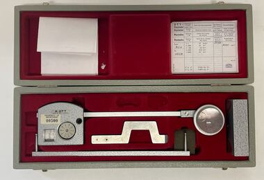
Instrument - Compensating Polar Planimeter, A. Ott Compensating Polar Planimeter. M8630
... A precision tool for measuring areas of both regular and irregular shape from maps, plans, blueprints, photographs, and other documents. ...University of Melbourne - 40500 A precision tool for measuring areas of both regular and irregular shape from maps, plans, blueprints, photographs, and other documents. ...Research and TrainingA precision tool for measuring areas of both regular and irregular shape from maps, plans, blueprints, photographs, and other documents. Simply trace the outline of an area with the cursor to obtain its size. A.OTT, Kempten. Made in West Germany. University of Melbourne - 40500 -
 Parks Victoria - Wilsons Promontory Lightstation
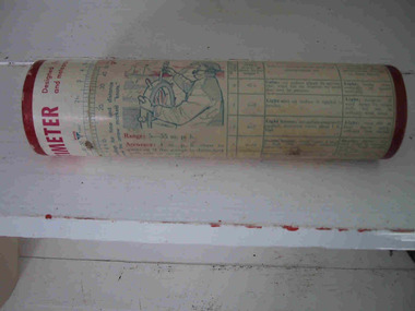
Container, Ventometer
... measuring equipment, such as digital air speed meters. Further information on this particular example, including perhaps the name of the manufacturer, may survive on the container but this has not been recorded. The small simple tool...measuring equipment, such as digital air speed meters. Further information on this particular example, including perhaps the name of the manufacturer, may survive on the container but this has not been recorded. The small simple tool ...The cylindrical cardboard container with lid formerly contained a ventometer, a small simple tool for measuring wind speed. It consisted of a clear tube containing a small diaphragm which had a hole in the bottom for wind to enter. Once the wind entered the tube it pushed up the diaphragm, indicating the rate of velocity. Ventometers were common devices that have since been replaced by more sophisticated measuring equipment, such as digital air speed meters. Further information on this particular example, including perhaps the name of the manufacturer, may survive on the container but this has not been recorded. The small simple tool for measuring wind speed pre-dates the electronic devices at Gabo Island.Tubed shaped cardboard container with lid to house instrument for measuring. (instrument is missing) Inscriptions and illustrations on exterior. -
 Creswick Campus Historical Collection - University of Melbourne
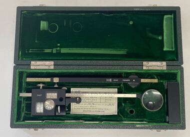
Instrument - Compensating Polar Planimeter, Keuffel & Esser 620015 KE Compensating Polar Planimeter
... A precision tool for measuring areas of both regular and irregular shape from maps, plans, blueprints, photographs, and other documents. ...A precision tool for measuring areas of both regular and irregular shape from maps, plans, blueprints, photographs, and other documents. ...Research and TrainingA precision tool for measuring areas of both regular and irregular shape from maps, plans, blueprints, photographs, and other documents. Simply trace the outline of an area with the cursor to obtain its size. The 620015 Paragon model features adjustable-length tracer arm measures and adjustable-length pole armK&E Germany Paragon.31427. Hand engraved: VSF006. -
 Flagstaff Hill Maritime Museum and Village
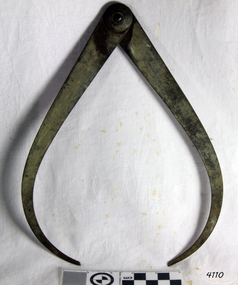
Calipers, Moore & Wright, 1925-1935
... Currently part of the Bower Meteorology UK Group, they still produce superb tools & measuring instruments in Sheffield. The subject item is made from high-grade carbon silver tool steel with the patented 'Firm Lock' joint, that identifies the maker as Moore & Wright....Currently part of the Bower Meteorology UK Group, they still produce superb tools & measuring instruments in Sheffield. The subject item is made from high-grade carbon silver tool steel with the patented 'Firm Lock' joint, that identifies the maker as Moore & Wright. ...Established in 1906, Frank Moore soon became well known amongst discerning tradespeople for the quality & accuracy of his tools. The Company was acquired by John Shaw & Son in 1945 & James Neill & Co in 1970. Currently part of the Bower Meteorology UK Group, they still produce superb tools & measuring instruments in Sheffield. The subject item is made from high-grade carbon silver tool steel with the patented 'Firm Lock' joint, that identifies the maker as Moore & Wright.A tool used for external measurement of items made by a maker who patented the "firm lock" jointing system now used on many different types of tools in many different industries. These items are now collectible and quite rare as a result are sought by tool collectors in the USA and UK.‘Firm Joint’ external measuring calipers believed made by Moore & Wright. Impressed into the metal "L A J S" (Probably the owner and company that used the item nothing to do with manufacturing) flagstaff hill, warrnambool, shipwrecked-coast, flagstaff-hill, flagstaff-hill-maritime-museum, maritime-museum, shipwreck-coast, flagstaff-hill-maritime-village, calipers, callipers, external calipers, outer caliper, pottery tools, masonry tools, glass making tools, external measurement -
 Flagstaff Hill Maritime Museum and Village
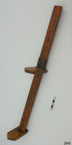
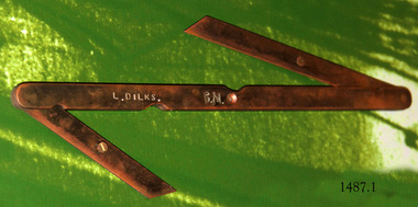
Tool - Bevel gauge, Mid-to-late 20th century
... The double bevel gauge is used as a drawing tool, to measure, set angles and transfer angles. ...Flagstaff Hill Maritime Museum and Village 89 Merri Street Warrnambool great-ocean-road The double bevel gauge is used as a drawing tool, to measure, set angles and transfer angles. ...The double bevel gauge is used as a drawing tool, to measure, set angles and transfer angles. The shipwright’s tools on display in the Great Circle Gallery are connected to the maritime history of Victoria through their past owner, user and donor, Laurie Dilks. Laurie began his career as a shipwright in the mid-1900s, following in the wake of the skilled carpenters who have over many centuries used their craft to build and maintain marine vessels and their fittings. You can see Laurie’s inscription on the tool called a ‘bevel’. Laurie worked for Ports and Harbours, Melbourne, for over 50 years, beginning in the early 1960s. He and a fellow shipwright inscribed their names on a wheelhouse they built in 1965; the inscription was discovered many decades later during a repair of the plumbing. Many decades later Laurie worked on the Yarra moving barges up and down the river and was fondly given the title ‘Riverboat Man’ His interest in maritime history led him to volunteer with the Maritime Trust of Australia’s project to restore and preserve the historic WWII 1942 Corvette, the minesweeper HMAS Castlemaine, which is a sister ship to the HMAS Warrnambool J202. Laurie Dilks donated two handmade displays of some of his tools in the late 1970s to early-1980s. The varnished timber boards displayed the tools below together with brass plaques. During the upgrade of the Great Circle Gallery Laurie’s tools were transferred to the new display you see there today. He also donated tools to Queenscliffe Maritime Museum and Clunes Museum.The shipwright’s tools on display in the Great Circle Gallery are connected to the maritime history of Victoria through their past owner, user and donor, Laurie Dilks. Laurie began his career as a shipwright at Ports and Harbours in Melbourne in the mid-1900s, following in the wake of the skilled carpenters who have over many centuries used their craft to build and maintain marine vessels and their fittings.This double bevel gauge has three lengths of flat brass that swivel at the joints. The long piece has curved ends and indented arcs, one on each side, along the length. The short pieces have diagonal ends. The centre length has a hole through the middle. The short pieces have a screw with its head above the flat brass. The tool has an inscription. It once belonged to shipwright Laurie Dinks.Bevel marked "L DILKS" "G. M."flagstaff hill, warrnambool, great ocean road, shipwreck coast, maritime museum, maritime village, shipwright, carpenter, shipbuilding, ship repairs, hand tool, equipment, ship maintenance, cooper, tool, marine technology, bevel, drawing tool, measuring tool, laurie dilks, l dilks, port and harbours melbourne -
 Warrnambool and District Historical Society Inc.
Instruments, Measuring tool, CLate 19th century
... Notches on inner rim at 90 degrees intervals. Measuring tool Instruments ...This instrument is a folding arm protractor. It is used for measuring angles on the vertical and horizontal planes. The two folding arms have small metal support springs where they are attached to provide support and the other ends have pins with which to mark particular points. A screw mechanism on the rim allows fine tuning of plotting. Chadburn, Brothers were fine instrument makers of Sheffield making optical and nautical instruments during the 19th century. This item was donated by a local resident whose grandfather Carl Spence was a bridge builder who worked on the Warrnambool Breakwater extension c 1919. This item has scientific significance which is possibly linked via the owner to one of Warrnambool's most well known landmarks.Brass, circular instrument with fold out sections which are hinged and a movable section. The circular part is marked in degrees around the circle. Notches on inner rim at 90 degrees intervals. Chadburn ,Brothers Sheffield. Graduated scale measuring 360 degrees.warrnambool, warrnambool breakwater -
 Warrnambool and District Historical Society Inc.
Functional object - Cloth Chart, A.E. Putnam Co. Iowa, U.S.A, c. 1896
... tool in local social and economic history. The possible connection to Swintons Stores is important as this business operated from 1865 to 2024 and was one of the longest-surviving family businesses in Australia. General Stores in Warrnambool Swintons Stores in Warrnambool Vintage Measuring ...This item was used to measure accurately the length of cloth on a bolt of material without unwinding it. It also measured lace, all types of textiles and spools of ribbon. It is surmised it would have been used in general stores or department stores in the late 19th and early 20th centuries. This item was discovered in the late 1980s behind an old safe at Swintons Stores in Timor Street in Warrnambool. The item appears to have been used extensively and would have been very useful during a stocktake. It may have been used in the Swinton Stores which were first established in Timor Street in 1865 with one section of the stores selling furnishings, furniture, clothing and clothing materials. The item was manufactured by A.E. Putnam of Iowa, U.S.A. There was a patent registered in 1896 and a later 'improved' model with a patent date of 1907. This item is of considerable interest because of its rarity and survival, its connection to Warrnambool General Stores in the past and its value as a research tool in local social and economic history. The possible connection to Swintons Stores is important as this business operated from 1865 to 2024 and was one of the longest-surviving family businesses in Australia. This is a rectangular-shaped wooden pole with one slightly flattened side and numbers marked on each side in patterns resembling brick walls. At the top of the pole are two wooden pieces attached to the pole by metal clips held by screws. The two wooden pieces are attached at a slight angle to the pole. The lower wooden piece is movable along the pole and has incised numbers. The wooden pieces are rectangular in shape with a large curved piece cut out to form the shape of a pennant. The maker's name is incised into the metal on the top attached wooden piece. Putnam's Cloth Chart Copyrighted 1896 Patent Pend'ggeneral stores in warrnambool, swintons stores in warrnambool, vintage measuring instrument for cloth -
 Warrnambool and District Historical Society Inc.
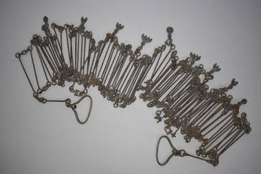
Chain link measure, Gunter's Chain, 19th Century
... measuring device that was used for over 250 years and has great historical and mathematical significance. If it is correct that it was used by Gilbert Nicol when the Warrnambool to Hamilton Road was built then it has considerable local significance and dates back to the 19th century. Gunter’s Chain Land Measurement Tools ...A Gunter’s Chain, an old land surveying instrument, is named after its inventor, Edmund Gunter (1581-1626), an English mathematician and astronomer. It was first produced in 1620. The tool has 100 links and is 66 feet or one chain long. The links are marked off in groups of ten by metal tags or rings. A quarter chain (25 links) is called a rod or pole and ten chains make a furlong and 80 chains a mile. The traditional cricket pitch is 22 yards or one chain long. This chain is said to have been used by Gilbert Nicol when the Warrnambool to Hamilton Road was constructed in the 19th century. Gilbert Nicol was an early settler in Warrnambool who, with John Craig, established the first hotel (and the first building) in Warrnambool in 1847. Nicol later owned the property ‘Rosehill’ in the Warrnambool area. As the chain was given to the Warrnambool and District Historical Society by the Town Clerk, Keith Arnel, it is likely that the chain was one of the items in the old Warrnambool MuseumThis Gunter’s Chain is of importance because it is an early land measuring device that was used for over 250 years and has great historical and mathematical significance. If it is correct that it was used by Gilbert Nicol when the Warrnambool to Hamilton Road was built then it has considerable local significance and dates back to the 19th century. This is a metal tool which consists of 100 metal pieces or links joined together by loops at each end with two metal loops in between each link. The links joined together form a chain. The two ends of the chain have small metal handles attached. At intervals along the chain there are additional rings or metal pieces attached. The metal is very rusted.gunter’s chain, land measurement tools, history of warrnambool -
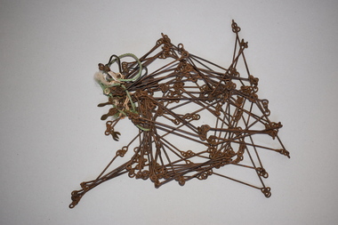 Warrnambool and District Historical Society Inc.
Chain link measure, Gunter, Early 20th century
... It is an early land measuring tool that was used for over 250 years and has great historical and mathematical significance. ...This Gunter’s Chain, an old land surveying instrument, is named after its inventor, Edmund Gunter (1581-1626), an English mathematician and astronomer. It was first produced in 1620. The tool has 100 links and is 66 feet or one chain long. The links are marked off in groups of ten by metal rings or tags. A quarter chain (25 links) is called a rod or pole and ten chains make a furlong and 80 chains make a mile. The traditional cricket pitch is 22 yards or one chain long. This Gunter’s Chain is of considerable significance because: 1. It is an early land measuring tool that was used for over 250 years and has great historical and mathematical significance. A Gunter’s Chain would have been used when forming and building local roads from the earliest days of settlement. 2. It has a possible local connection as it was given to the Historical Society by a local person in 1965 and possibly came from the property of ‘Rosehill’ This is a metal tool which consists of 100 metal pieces or links joined together by loops at each end with two metal loops in between each link. The links joined together form a chain. The two ends of the chain have small metal handles attached At intervals along the chain there are additional rings or metal pieces attached. Some white and green rope material has been used to bundle up the chain. The metal is somewhat rusted. gunter’s chain, land measurement tools, history of warrnambool -
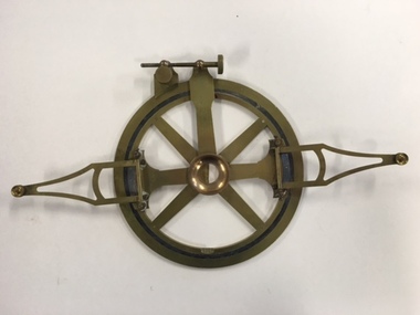
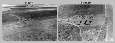 Bendigo Military Museum
Photograph - RA Svy Project C4 Aerodist Operation, Eastern Arnhem Land, NT, 1967
... measure distances between non-intervisible ground survey stations, using the aircraft as an intermediate station. Lower order geodetic results could be achieved by survey network trilateration. The measured distances between stations formed survey networks from which each station’s latitude and longitude was computed. Aerodist MRC2 was RA Svy’s major horizontal control survey tool...measure distances between non-intervisible ground survey stations, using the aircraft as an intermediate station. Lower order geodetic results could be achieved by survey network trilateration. The measured distances between stations formed survey networks from which each station’s latitude and longitude was computed. Aerodist MRC2 was RA Svy’s major horizontal control survey tool ...This is a set of 30 photographs of Royal Australian Survey Corps (RA Svy) personnel from Central Comd Fd Svy Unit (Adelaide) on Aerodist survey operation - Project C4 in Eastern Arnhem Land, Northern Territory in 1967. Photos of personnel were taken either at the operations base at Numbulwar or the main base at Gove (Nhulunbuy). RA Svy conducted nineteen Aerodist operations for 12 years from 1964 to 1975. Aerodist MRC2 was a tellurometer-based system adapted for aircraft to accurately measure distances between non-intervisible ground survey stations, using the aircraft as an intermediate station. Lower order geodetic results could be achieved by survey network trilateration. The measured distances between stations formed survey networks from which each station’s latitude and longitude was computed. Aerodist MRC2 was RA Svy’s major horizontal control survey tool for mainly medium scale topographic mapping (scale 1:100,000 Class A being spatially accurate to within 50 metres) in PNG, northern NT, north-west WA, Kalimantan Barat (West) Indonesia, Sumatra Indonesia, Gulf of Carpentaria and Cape York, QLD. In 1967, the Aerodist MRC2 Master equipment was installed in the aircraft featured in this set of photos, Executive Air Services’ (Essendon VIC) Grand Aero Commander VH-EXX. It was the same aircraft type and company contracted to Division of National Mapping for Aerodist MRC2 surveys. From July to October 1967 the aircraft was attached to Central Comd Fd Svy Unit (Adelaide - Major Don Ridge) on Project C4 eastern-Arnhem Land NT, where 317 Aerodist lines measuring 17,300 line miles were successfully completed. This was the most productive Aerodist project thus far. The most common helicopter used by RA Svy up to 1972 was the civilian Bell 47G-2 and the Sioux Light Observation Helicopters (LOH), the Australian Army’s equivalent featured in this photo set. These light observation helicopters had a limiting load carrying capacity of up to about 500 pounds. By comparison, one Aerodist team including two people weighed up to 1,500 pounds. Source: Royal Australian Survey Corps – Aerodist Years 1964-1975 by Peter Jensen. Refer to Item 9061.26P for more photos taken during this Aerodist survey operation.This is a set of 30 photographs of Royal Australian Survey Corps (RA Svy) personnel on Aerodist survey operations in Eastern Arnhem Land, Northern Territory in 1967. The photographs are on 35mm negative film and scanned at 96 dpi. They are part of the Army Survey Regiment’s Collection. .1) to .4) - black & white, 20th August 1967, Project C4 Aerodist Operations Base - Numbulwar, NT. .5) - Photo, black & white, 1967. Probable wrecked Indonesian fishing vessel. .6) to .8) - Photo, black & white, 1967. Unidentified survey operations base, L to R: unidentified personnel. .9) - Photo, black & white, 1967. Unidentified survey operations base, unidentified soldier driving a Haflinger 4x4 Light utility vehicle. .10) - Photo, black & white, 1967. Unidentified survey operations base, L to R: unidentified technician. .11) - Unidentified technician reading two survey altimeters to compute corrections to the measured distances for atmospheric refraction and to compute the sea level distances from the slope distances aircraft to the ground stations. .12) - Photo, black & white, 1967. Survey operations base, L to R: unidentified (x3), W01 Pat Wood BEM, unidentified. .13) to .16) - Photo, black & white, 1967. Unidentified personnel operating remote Aerodist MRC2 ground instruments. .17) to .18) - Photo, black & white, 1967. Unknown RA Svy office location. .19) to .20) - Photo, black & white, 1967. Aerodist MRC2 Master equipment. .21) to .22) - Photo, black & white, 1967. Aero Commander VH-EXX probably at Gove, NT, Central Comd Fd Svy Unit (Adelaide) – OC Major Don Ridge. .23) to .25) - Photo, black & white, 1967. Aero Commander VH-EXX probably at Gove, NT. Unidentified personnel. .26) - Photo, black & white, 1967. Aero Commander VH-EXX probably at Gove, NT. Aerodist antenna pods are visible on the aircraft. .27) to .29) - Photo, black & white, 1967. Australian Army Sioux Light Observation Helicopter (LOH) probably at Gove, NT. .30) - Photo, black & white, 1967. Panelled U337 survey station, visible as a white cross on aerial identification photo..1P to .2P – date and location on edge of film negative. .5P to .28P – no annotations .29P - annotated in white ‘RW-JEP Gove NT’ .30P - annotated in white ‘U337 Spool No1 Jun67’royal australian survey corps, rasvy, army survey regiment, army svy regt, fortuna, asr, aerodist, surveying, central comd fd svy unit -
 Bendigo Military Museum
Photograph - RA Svy Project C4 Aerodist Operation, Eastern & Western Arnhem Land, NT, 1967, 1968
... measure distances between non-intervisible ground survey stations, using the aircraft as an intermediate station. Lower order geodetic results could be achieved by survey network trilateration. The measured distances between stations formed survey networks from which each station’s latitude and longitude was computed. Aerodist MRC2 was RA Svy’s major horizontal control survey tool...measure distances between non-intervisible ground survey stations, using the aircraft as an intermediate station. Lower order geodetic results could be achieved by survey network trilateration. The measured distances between stations formed survey networks from which each station’s latitude and longitude was computed. Aerodist MRC2 was RA Svy’s major horizontal control survey tool ...This is a set of 26 photographs of Royal Australian Survey Corps (RA Svy) personnel from Central Comd Fd Svy Unit (Adelaide) on Aerodist survey operation - Project C4 in Eastern Arnhem Land, Northern Territory in 1967 (photos .4P to .26P) and in Western Arnhem Land, Northern Territory in 1968 (photos .1P to .3P). Photos of personnel were taken either at the operations base at Numbulwar or the main base at Gove (Nhulunbuy). RA Svy conducted nineteen Aerodist operations for 12 years from 1964 to 1975. Aerodist MRC2 was a tellurometer-based system adapted for aircraft to accurately measure distances between non-intervisible ground survey stations, using the aircraft as an intermediate station. Lower order geodetic results could be achieved by survey network trilateration. The measured distances between stations formed survey networks from which each station’s latitude and longitude was computed. Aerodist MRC2 was RA Svy’s major horizontal control survey tool for mainly medium scale topographic mapping (scale 1:100,000 Class A being spatially accurate to within 50 metres) in PNG, northern NT, north-west WA, Kalimantan Barat (West) Indonesia, Sumatra Indonesia, Gulf of Carpentaria and Cape York, QLD. In 1967, the Aerodist MRC2 Master equipment was installed in the aircraft featured in this set of photos, Executive Air Services’ (Essendon VIC) Grand Aero Commander VH-EXX. It was the same aircraft type and company contracted to Division of National Mapping for Aerodist MRC2 surveys. From July to October 1967 the aircraft was attached to Central Comd Fd Svy Unit (Adelaide - Major Don Ridge) on Project C4 eastern-Arnhem Land NT, where 317 Aerodist lines measuring 17,300 line miles were successfully completed. This was the most productive Aerodist project thus far. The most common helicopter used by RA Svy up to 1972 was the civilian Bell 47G-2 and the Sioux Light Observation Helicopters (LOH), the Australian Army’s equivalent featured in this photo set. These light observation helicopters had a limiting load carrying capacity of up to about 500 pounds. By comparison, one Aerodist team including two people weighed up to 1,500 pounds. In 1968, after completion of the Kimberley Aerodist Operation project, the Aerodist system in VH-EXX was immediately deployed to western-Arnhem Land NT for Central Comd Fd Svy Unit (Adelaide - Major Don Ridge) to complete the mapping control across northern NT from mid-July to October. The Aerodist MRC2 Remote antenna seen in Photos .24P to .26P is mounted on a 20 foot pole tower. The antenna direction was controlled by wires/ropes to the two arms under the dish at right angles. The antenna elevation could be changed to the vertical for aircraft height checks as seen in photo .25P. Source: Royal Australian Survey Corps – Aerodist Years 1964-1975 by Peter Jensen. Refer to Item 6449.30P for more photos taken during these Aerodist survey operations.This is a set of 26 photographs of Royal Australian Survey Corps (RA Svy) personnel on Aerodist survey operations in Eastern Arnhem Land, Northern Territory in 1967 and Western Arnhem Land, Northern Territory in 1968. The photographs are on 35mm negative film and scanned at 96 dpi. They are part of the Army Survey Regiment’s Collection. .1) to .2) – Photo, black & white, 1968, unidentified soldier with an opened can of food, possibly bully beef. .3) – Photo, black & white, 15 Aug 1968, aerial view of terrain taken from a helicopter in vicinity of MILINGIMBI SIERRA. .4) – Photo, black & white, 1967, aerial view of an island taken from a helicopter. .5) & .6) – Photo, black & white, 1967, unidentified soldier driving a Haflinger 4x4 Light utility vehicle with trailer. .7) – Photo, black & white, 1967, unidentified surveyors taking vertical measurements with a leveling instrument and staff. .8) – Photo, black & white, 1967, Australian Army Sioux Light Observation Helicopter (LOH) with float removed. .9) to .11) – Photo, black & white, 1967, Australian Army Sioux Light Observation Helicopter (LOH) with floats. .12) – Photo, black & white, 1967, civilian Bell 47G-2 helicopter (Australian Army Sioux LOH equivalent) refuelled. .13) – Photo, black & white, 1967, survey station on coastline surrounded by white plastic aerial photographic identification panels lined with rocks. .14) & .15) – Photo, black & white, 1967, soldier (possibly a signaller from RA Sigs) operating a radio. .16) – Photo, black & white, 1967, Central Comd Fd Svy Unit Operations Section tent, Main Base Gove (Nhulunbuy) L to R: SPR Harry Dunn, WO1 Pat Wood BEM. .17) – Photo, black & white, 1967, Central Comd Fd Svy Unit Operations Section tent, Main Base Gove (Nhulunbuy) L to R: unidentified, WO1 Pat Wood BEM. .18) – Photo, black & white, 1967, Central Comd Fd Svy Unit Operations Section, Main Base Gove (Nhulunbuy), unidentified Australian Army Catering Corps cook preparing meals. .19) – Photo, black & white, 1967, Central Comd Fd Svy Unit Operations Section, Main Base Gove (Nhulunbuy) mess tent in readiness for meals. .20) – Photo, black & white, 1967, Bank of batteries in transit boxes undergoing recharging using generators. .21) – Photo, black & white, 1967, A topographic survey identification plaque set in a concrete block being weighed using a set of scales hanging from slaughtering gallows. .22) – Photo, black & white, 1967, CPL (Geoff or Gary) Larkin operating the remote Aerodist MRC2 ground instrument at Veronica Island, located north of Nhulunbuy. .23) – Photo, black & white, 1967, L to R: CPL (Geoff or Gary) Larkin with unidentified surveyor operate the remote Aerodist MRC2 ground instrument at Venica Island, located north of Nhulunbuy. .24) & .25 – Photo, black & white, 1967, The Aerodist MRC2 Remote antenna. .26) – Photo, black & white, 1967, The Aerodist MRC2 Remote antenna.The following photos are annotated in black ink on edge of film negative: .3P – ’15 Aug ’68, 2000’, 1-C18 ’68 MILINGIMBI SIERRA’ .4P – ’U462’ .8P – ‘1-C3/67 Float Removed’ .13P – ‘U477 10-C3/67 .20P - ‘2-C3/67 Bank of Chargers’ .21P - ‘3-C3/67 Gallows & Scales’ .22P - ‘0462 VERONICA ISLAND NT, CPL Larkin’ .23P - ‘0462 VERONICA ISLAND NT’ .24P - ‘4-C3/67 20’ Aerodist Tower’ .25P - ‘5-C3/67 20’ Aerodist Tower’ .26P - ‘6-C3/67 20’ Aerodist Tower’royal australian survey corps, rasvy, army survey regiment, army svy regt, fortuna, asr, aerodist, surveying, central comd fd svy unit -
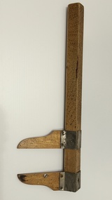
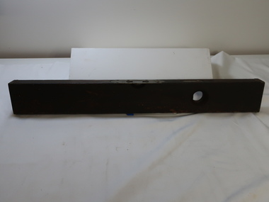 Kiewa Valley Historical Society
Tool - Spirit Level
... measure is in the centre on the narrower ledge of wood. On the centre wider edges is a groove to assist in hold in the spirit level steady. Above the glass level Tool ...The Stanley Works was founded by Frederick Trent Stanley in 1843 located in New Britain, Connecticut USA. The Stanley Rule and Level Company was founded by Frederick's cousin Henry Stanley in 1857. Stanley introduced the first steel tape, Stanley introduced utility knives in 1936. Stanely buildt the largest hand tool plant in the world in New Britain, CT (Connecticut). In 1920, the Rule and Level Co. merged with the Stanley Works, which in turn merged with Black and Decker in 2010.Owned by Kiewa valley resident, Lankey Higginson.Solid wooden plank with brass attached by screws. brass plates at each end, around the level 'window' and further along. Also with a 'badge'. This latter one is beside a ound hollow which has a level window to measure the vertical side. The horizontal level measure is in the centre on the narrower ledge of wood. On the centre wider edges is a groove to assist in hold in the spirit level steady. Above the glass levelAbove the glass level, inscribed on a brass plate is "Stanley / Rule and Level Co. / New Britain Conn. U.S.A. / Pat. 6 -2-91 and 6 -28 -96" Also, 2 small brass plaques / badges inscribed: "ADJ pat. Feb. 1890 / screw."stanley rule and level co., spirit level, higginson family -
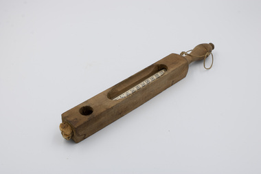 Emerald Museum & Nobelius Heritage Park
Tool - Floating Dairy Thermometer, Circa 1930
... Similar models of floating thermometers were used to measure the temperature of bath water in hospitals; these functioned identically but had different markers for their different use case. This was a specialised tool ...This Floating Dairy Thermometer was used on the A’Vard farm between 1930 and 1964. It is designed to enable the easy measuring of the temperature of liquids. In particular it facilitates checking whether dairy is at the right temperature for cheesemaking, churning and freezing. It was made to remain at the surface of the liquid, allowing workers to accurately take temperature readings with relative ease. Similar models of floating thermometers were used to measure the temperature of bath water in hospitals; these functioned identically but had different markers for their different use case.This was a specialised tool used historically in the local dairy farming industry.A glass vial thermometer housed in a wooden case. The glass thermometer has temperature markings visible from 20 to 120 degrees Fahrenheit. There are long gaps with rounded ends on the front and rear of the wooden casing, allowing a user to see the temperature markings and labels. There is also a round hole in the front and rear of the wooden casing near the bottom, exposing the tip of the thermometer. At the top of the wooden casing is a handle, with string passed through a small hole allowing for the suspension of the thermometer from the string.Front side of glass vial, middle: "Made / in Germany" Front side of glass vial, upper: "FLOATING DAIRY THERMOMETER" Rear side of glass vial, 85 degrees: "85 Cheese" Rear side of glass vial, 62 degrees: "62 Churning" Rear side of glass vial, 32 degrees: "32 Freezing"a’vard family, farming, tools, 20th century, a’vard dairy farm, dairy -
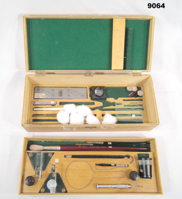 Bendigo Military Museum
Container (item) - Cartographic Draughting Tool Box, Australian Defence Industries. ADI, 1956
... tools box. Enclosed in the base of the box is: - a. Parallel ruler 6", metal and brass. b. Feeler gauges 7 set. 60 x 10 mm. c. Pen ink, screw adjustable nib thickness, bone handle. d. Crow quill pen holder, plastic. e. Folding eye glass measuring...tools box. Enclosed in the base of the box is: - a. Parallel ruler 6", metal and brass. b. Feeler gauges 7 set. 60 x 10 mm. c. Pen ink, screw adjustable nib thickness, bone handle. d. Crow quill pen holder, plastic. e. Folding eye glass measuring ...Equipment / Cartographic tools box. Enclosed in the base of the box is: - a. Parallel ruler 6", metal and brass. b. Feeler gauges 7 set. 60 x 10 mm. c. Pen ink, screw adjustable nib thickness, bone handle. d. Crow quill pen holder, plastic. e. Folding eye glass measuring (linen filter). Maker "Polychrome". 4 cm square. f. Plastic template various shapes. 60 X 95 mm. g. Repromat Registration studs set of 3. 20mm diameter. Stainless steel. h. Stainless steel, straight edge small. 38mm long. In lift out tray: - a. 2 X plastic scribing cutter holders, 3 leg fixed. b. Eye glass measuring "Leitz" WETZLAR, 45 mm High X 35 mm Dia. c. Jeweler screwdriver. 2 mm Blade. Moore & Wright, Sheffield, England. d. Black colored lead pencil. e. Pin vice. (Draughtsman's pricker) f. 4 X assorted paint brushes, artists. Built into the lid is a scribing tip holder with the capacity to hold 12 sapphire cutting tools: - a. 1 X 0.004" sapphire cutting tool. rasvy, royal australian army service corps, fortuna, army survey regiment, army svy regt, asr -
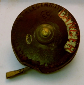 Kiewa Valley Historical Society
Tape Measure 33ft, Early to mid 1900's
... It provides evidence that small measuring equipment used in the construction and the continuing maintenance of the scheme was of the imperial measure and used by construction workers who remained and settled in the town of Mount Beauty and Kiewa Valley long after the construction period. imperial tape measure distance measures imperial tools Embossed in the leather casing"MADE IN ENGLAND" and around the inner circle "HOCKLEY ABBEY" and "JOHN RABONE & SONS" This flexible metallic measuring tape (33 ft in length) is contained in a round circular leather bound container. ...This flexible measuring tape was used by the SEC Victoria in the mid to late 1900's. It was in a period before digital measuring instruments were in use. This is a 33ft long tape measure and would have been used by the construction workers when building the Kiewa Valley Hydro System. The warning details (embossed into the leather covering) was to warn users to be careful not to use the tape near live electricity terminals or linkages. This tape was produced mainly for wooden structures and not electricity conductive material. This was during the 1950's to 1960's.This imperial tape measure is very significant to the Kiewa Valley as it was used in the construction of the Kiewa Valley Hydro Scheme of the 1950's-1960's. It provides evidence that small measuring equipment used in the construction and the continuing maintenance of the scheme was of the imperial measure and used by construction workers who remained and settled in the town of Mount Beauty and Kiewa Valley long after the construction period. This flexible metallic measuring tape (33 ft in length) is contained in a round circular leather bound container. It has brass fittings (winder and tape guide) and is stitched with heavy grade twine. The tape measure is graduated in feet and inches on one side and yards on the other. Embossed in the leather casing"MADE IN ENGLAND" and around the inner circle "HOCKLEY ABBEY" and "JOHN RABONE & SONS"imperial tape measure, distance measures, imperial tools -
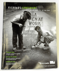 Orbost & District Historical Society
book, Vic Roads Centenary 1913 -2013, 2013
... measures. (ref VicRoads) This item is one of several books donated by David Jellie at a presentation to Orbost Historical Society. He was a contributor to the book and was the engineer for the Snowy River Bridge (Princes Highway) at Orbost 1974-1976. This book is a useful reference tool ...The publication, VicRoads Centenary: Keeping Victorians Connected for 100 Years, looks at the people and projects that define VicRoads’ history. Written by current and former VicRoads’ employees, the publication details the organisation’s portfolio of major projects, which includes the Great Ocean Road, Hume Highway and Eastern Freeway. Other sections report on Victoria’s world-first road safety initiatives, VicRoads’ use of technology and sustainability measures. (ref VicRoads) This item is one of several books donated by David Jellie at a presentation to Orbost Historical Society. He was a contributor to the book and was the engineer for the Snowy River Bridge (Princes Highway) at Orbost 1974-1976.This book is a useful reference tool on the history of road construction in Victoria including East Gippsland.A thick, bound paperback book, titled "VicRoads Centenary Keeping Victorians Connected for 100 Years". On the front cover is a black/white photograph of two men working on a road. One has a pick. The book contains the history of VicRoads, photographs, maps and advertisements. Some are b/w. Others are coloured.vicroads book roads snowy-river-bridge jellie-david -
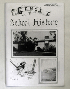 Orbost & District Historical Society
book, Peisley, Allan B, Genoa School History, second half 20th century
... measure proved seemingly permanent as it was not until 1953 that a new school was built on the present site, ½ mile W of Genoa. This school was opened by the late Sir Albert Lind on 15th of August 1953, the original name being amended to Genoa State School. Since then much has been done to maintain the grounds and buildings at a high standard. This item is a useful reference tool ...The book was compiled by Allan B. Peisley. In 1891 a pineboard, portable school building was sent from Melbourne to Gabo by schooner, and transported to a site approximately 1½ miles SE of Genoa. When erected by Henry Bucknall, it was listed as Genoa River School. It opened on 24th of August with an enrolment of approximately 20 pupils under the guidance of Algernon de Havilland, and served the district until 1928 when a combination of white ants and dry rot caused the building to be abandoned. School was held in the Genoa hall as a 'temporary' measure until a new building was erected, and it was during this period that N. A. Wakefield, later lecturer and author of natural history articles and books, served as HT. The ‘temporary' measure proved seemingly permanent as it was not until 1953 that a new school was built on the present site, ½ mile W of Genoa. This school was opened by the late Sir Albert Lind on 15th of August 1953, the original name being amended to Genoa State School. Since then much has been done to maintain the grounds and buildings at a high standard.This item is a useful reference tool on the history of Genoa in East Gippsland.A book of 36 pp titled Genoa School History. On the front cover are black and white images of buildings and wrens. The text is black. The pages have been photocopied.education genoa -
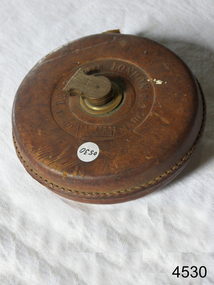
 Flagstaff Hill Maritime Museum and Village
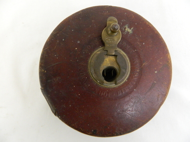
Tape measure
... Flagstaff Hill Maritime Museum and Village 89 Merri Street Warrnambool great-ocean-road James S Steele tool box Flagstaff Hill Warrnambool Shipwrecked-coast Flagstaff-Hill Flagstaff-Hill-Maritime-Museum Maritime-Museum Shipwreck-coast Flagstaff-Hill-Maritime-Village Tape measure steel 66 feet long. ...James S Steele tool boxTape measure steel 66 feet long. Made by Henry Boker, Germany. Leather covered case with brass trimmings 100mm diameter 22mm wideflagstaff hill, warrnambool, shipwrecked-coast, flagstaff-hill, flagstaff-hill-maritime-museum, maritime-museum, shipwreck-coast, flagstaff-hill-maritime-village -
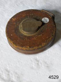
 Flagstaff Hill Maritime Museum and Village
Tape measure
... Flagstaff Hill Maritime Museum and Village 89 Merri Street Warrnambool great-ocean-road James S Steele tool box Flagstaff Hill Warrnambool Shipwrecked-coast Flagstaff-Hill Flagstaff-Hill-Maritime-Museum Maritime-Museum Shipwreck-coast Flagstaff-Hill-Maritime-Village Tape measure linen 66 feet long. ...James S Steele tool boxTape measure linen 66 feet long. Made by Dean of London Leather stitched case with brass trimmings. 130mm diameter 33mm wideflagstaff hill, warrnambool, shipwrecked-coast, flagstaff-hill, flagstaff-hill-maritime-museum, maritime-museum, shipwreck-coast, flagstaff-hill-maritime-village