Showing 3 items matching "melway 21j6"
-
 Eltham District Historical Society Inc
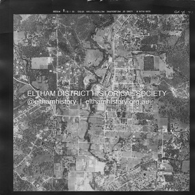
Photograph - Aerial Photograph, Landata, Eltham, Main Road; Mt Pleasant Rd to Railway Rd, Dec. 1945
... ...Melway 21J6...Historic Aerial Imagery Source: Landata.vic.gov.au Aerial Photo Details: Project No :65 Project : MELBOURNE AND METROPOLITAN PROJECT NO. 2 Run : 8 Frame : 70 Date : 01/1951 Film Type : B/W Camera : EAG9 Flying Height : 12200 Scale : 12000 Film Number : 1419 GDA2020 : 37°43'06"S, 145°08'45"E MGA2020 : 336589, 5823811 (55) Melways : 21 J6 (ed. 42) Aerial Photo Eltham Main Road Henry Street Arthur Street Bolton Street Eltham-Yarra Glen Road Neil Webster Collection 1951-01 Dave Lyon House Ernie Andrew house Karingal Road Melway 21J6 Mount Pleasant Road railway road A3 photo print and electronic PDF file Eltham, Main Road; Mt Pleasant Rd to Railway Rd Photograph Aerial Photograph Landata ...Centred on Main Rd and Henry St, Eltham bounded by Railway Road to north, Mount Pleasant Road at Main Road to south, top of the hill in Arthur Street to east and Karingal Drive at Sherbourne Road to west. Historic Aerial Imagery Source: Landata.vic.gov.au Aerial Photo Details: Project No :65 Project : MELBOURNE AND METROPOLITAN PROJECT NO. 2 Run : 8 Frame : 70 Date : 01/1951 Film Type : B/W Camera : EAG9 Flying Height : 12200 Scale : 12000 Film Number : 1419 GDA2020 : 37°43'06"S, 145°08'45"E MGA2020 : 336589, 5823811 (55) Melways : 21 J6 (ed. 42)aerial photo, eltham, main road, henry street, arthur street, bolton street, eltham-yarra glen road, neil webster collection, 1951-01, dave lyon house, ernie andrew house, karingal road, melway 21j6, mount pleasant road, railway road -
 Eltham District Historical Society Inc
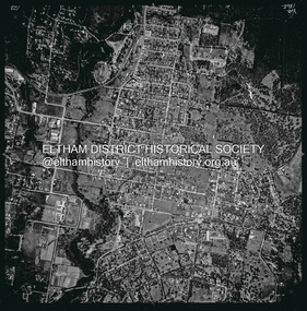
Photograph - Aerial Photograph, Landata, Eltham, Vic, Apr. 1963
... ...Melway 21J6...Historic Aerial Imagery Source: Landata.vic.gov.au Aerial Photo Details: Project No :486 Project : MELBOURNE (1963) PROJECT Run : 6 Frame : 123 Date : 04/1963 Film Type : B/W Camera : RC8 Flying Height : 5100 Scale : 9600 Film Number : 1805 GDA2020 : 37°43'12"S, 145°08'54"E MGA2020 : 336800, 5823623 (55) Melways : 21 J6 (ed. 42) Aerial Photo Neil Webster Collection 1963-04 Bolton Steet Elsa Court Eltham John Street Main Road main road bridge Melway 21J6 Wattle Grove Digital jpg and electronic PDF file Eltham, Vic. ...Centred on present day John Street, Eltham between Main and Bible streets bounded by Elsa Court to north, Main Road Bridge to south, Wattle Grove to east and Bolton Street to west. Historic Aerial Imagery Source: Landata.vic.gov.au Aerial Photo Details: Project No :486 Project : MELBOURNE (1963) PROJECT Run : 6 Frame : 123 Date : 04/1963 Film Type : B/W Camera : RC8 Flying Height : 5100 Scale : 9600 Film Number : 1805 GDA2020 : 37°43'12"S, 145°08'54"E MGA2020 : 336800, 5823623 (55) Melways : 21 J6 (ed. 42)aerial photo, neil webster collection, 1963-04, bolton steet, elsa court, eltham, john street, main road, main road bridge, melway 21j6, wattle grove -
 Eltham District Historical Society Inc
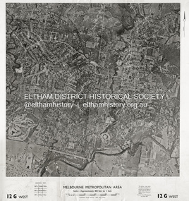
Photograph - Aerial Photograph, Central Plan Office, Eltham, Jan. 1960
... ...Melway 21J6.../Feb. 1960 Scale : 800 feet to 1 inch 37°43'18.2"S 145°08'13.0"E Melways : 21 J6 (ed. 42) Aerial Photo Lower Plenty Main Road Montmorency Eltham Eltham Lower Park Heidelberg Golf Club Hurstbridge Railway Line Main Road Eltham Yarra River 1960-01 Andrews Street Arthur Street Bolton Street Briar Hill Brougham Steet Dave Lyon House Eltham North Eltham-Yarra Glen Road Ernie Andrew house Eucalyptus Road Greensborough Railway Station henry street Karingal Road Melway 21J6 Montmorency Railway Station Mount Pleasant Road Progress Road railway road Southernwood Were Street Photo print on card 61 x 76 cm Eltham Photograph Aerial Photograph Central Plan Office ...Centred on Bolton Street and Brougham Street, Eltham bounded by Progress Road to north, Yarra River to south, Andrews Street and Euclyptus Road to east and Greensborough Railway Station to west. Historic Aerial Imagery Source: Central Plan Office Neg. No. 21451 (Print) Dept. of Lands & Survey and the Melb. & Metro. Board of Works. Aerial Photo Details: MELBOURNE METROPOLITAN AREA Section : 12 G West Date : Jan./Feb. 1960 Scale : 800 feet to 1 inch 37°43'18.2"S 145°08'13.0"E Melways : 21 J6 (ed. 42)aerial photo, lower plenty, main road, montmorency, eltham, eltham lower park, heidelberg golf club, hurstbridge railway line, main road eltham, yarra river, 1960-01, andrews street, arthur street, bolton street, briar hill, brougham steet, dave lyon house, eltham north, eltham-yarra glen road, ernie andrew house, eucalyptus road, greensborough railway station, henry street, karingal road, melway 21j6, montmorency railway station, mount pleasant road, progress road, railway road, southernwood, were street