Showing 386 items matching "mine sections"
-
 Bendigo Historical Society Inc.
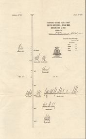
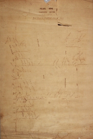
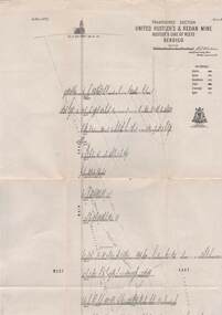
Map - UNITED HUSTLER'S & REDAN MINE - TRANSVERSE SECTIONS N & S OF SHAFT UNITED HUSTLER'S & REDAN MINE
... UNITED HUSTLER'S & REDAN MINE - TRANSVERSE SECTIONS N & S OF SHAFT UNITED HUSTLER'S & REDAN MINE...Mine... Transverse Sections N & S of Shaft United Hustler's & Redan Mine...Transverse Sections N & S of Shaft United Hustler's & Redan Mine on the Hustler's Line of Reef Bulletin No 33, Plate No XXX. ...Map UNITED HUSTLER'S & REDAN MINE - TRANSVERSE SECTIONS N & S OF SHAFT UNITED HUSTLER'S & REDAN MINE ...Transverse Sections N & S of Shaft United Hustler's & Redan Mine on the Hustler's Line of Reef Bulletin No 33, Plate No XXX. Map shows some of the stone encountered on the levels and depth. Geological Survey of Victoria emblem and signed by H A Whitdan, Underground Survey Office Bendigo, September 1913.mining, parish map, united hustler's & redan mine, transverse sections n & s of shaft united hustler's & redan mine, hustler's line of reef -
 Clunes Museum
Map - DOCUMENTS/MAP, 3 1887. .4 1891
... ...MINE SECTIONS...MINING, CLUNES GOLD MINES, MAPS, SECTIONS...SCALE 4 CHAINS TO AN INCH. .3 MAP OF GOLD MINING LEASE BLOCKS AT CLUNES .4 DRAWINGS OF SECTIONS, CLUNES GOLD MINES. SCALE 400 FEET TO AN NCH. ...Clunes Museum 36 Fraser Street enter building through Collins Place Clunes goldfields MINING, CLUNES GOLD MINES, MAPS, SECTIONS CLUNES GOLD MINING LEASES AERIAL PHOTOGRAPH MINE SECTIONS .1 ON BACK. ...MINING, CLUNES GOLD MINES, MAPS, SECTIONS.1 AERIAL VIEW OF CLUNES AND DISTRICT. COLOUR PHOTOGRAPH LAMINATED. .2 MAP OF MINING AREAS SHOWING EXCISED AREA. No. 9104. MINING DISTRICT OF BALLARAT. PARISH OF CLUNES. COUNTY OF TALBOT. SCALE 4 CHAINS TO AN INCH. .3 MAP OF GOLD MINING LEASE BLOCKS AT CLUNES .4 DRAWINGS OF SECTIONS, CLUNES GOLD MINES. SCALE 400 FEET TO AN NCH. ALL MOUNTED WITH PLASTIC HANGING STRIPS..1 ON BACK. CLUNES 1:25000 .2 ASSORTED HANDWITTEN NOTATIONS. .3 ASSORTED HANDWITTEN NOTATIONS. REPLACE IN DEPT. OF MINING REGISTRARS QUARTER ENDED 30TH JUNE 1887. P. 12.clunes, gold mining, leases, aerial photograph, mine sections -
 Coal Creek Community Park & Museum
Mine Cross Sections
... Mine Cross Sections...8520.1 - Diagram of 6 cross-section of the Korumburra coal mine area, showing topography, elevation, faults, coal seams and boreholes....Mine Cross Sections ...8520.1 - Diagram of 6 cross-section of the Korumburra coal mine area, showing topography, elevation, faults, coal seams and boreholes. -
 Bendigo Historical Society Inc.
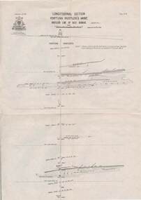
Document - SOUTH VIRGINIA MINE - LONGITUDINAL AND TRANS SECTIONS OF THE SOUTH VIRGINIA MINE
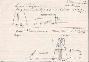
... SOUTH VIRGINIA MINE - LONGITUDINAL AND TRANS SECTIONS OF THE SOUTH VIRGINIA MINE...Mine... Longitudinal and Trans Sections of the South Virginia Mine...Handwritten and drawn longitudinal and trans sections of the South Virginia Mine. Both drawings have measurements in feet and inches. ...Document SOUTH VIRGINIA MINE - LONGITUDINAL AND TRANS SECTIONS OF THE SOUTH VIRGINIA MINE ...Handwritten and drawn longitudinal and trans sections of the South Virginia Mine. Both drawings have measurements in feet and inches. Gives measurements of poppet legs, buildings and part of mullock heap.document, gold, south virginia mine, longitudinal and trans sections of the south virginia mine -
 Bendigo Historical Society Inc.
Document - LANSELL'S BIG 180 MINE - CONDENSED HISTORICAL RECORD OF LANSELL'S BIG 180 MINE
... Lansell's 180 Mine 'Transverse Sections...History House 11 Mackenzie Street Bendigo goldfields DOCUMENT Gold lansell's big 180 mine Lansell's Big 180 Mine Condensed Historical Record of Lansell's Big 180 Mine Wittscheibe Ballerstadt Ernst Mueller Theodore Ballerstadt George Lansell North Old Chum Victoria Quartz Mines Dept Special Edition 'Australian Mining Standard' 1/6/1899 Mines Dept Booklet 'Bendigo Goldfield' 1936 Quarterly Reports Lansell's 180 Mine 'Transverse Sections Annals of Bendigo Mining Sections A Richardson's observations from old photographs and measurements of mining plans Measurements taked from Caleb Thomas' Report Mines Dept 1875 'Report on observation of Underground Temperature at Bendigo' James Stirling Government Geologist 1899 A Richardson Two handwritten and three typed copies of a Condensed Historical Record of Lansell's Big 180 Mine on the New Chum Line of Reef. ...Two handwritten and three typed copies of a Condensed Historical Record of Lansell's Big 180 Mine on the New Chum Line of Reef. Notes include location, shaft, first worked, size of lease, plant, engine house, boiler rooms, mullock heap, early history, Prominent, best gold, underground connections, pressurised hot water, diamond drill bores and a table with depths and the increase in temperature with the depth (in Fahr). Albert Richardson Collection. document, gold, lansell's big 180 mine, lansell's big 180 mine, condensed historical record of lansell's big 180 mine, wittscheibe, ballerstadt, ernst mueller, theodore ballerstadt, george lansell, north old chum, victoria quartz, mines dept special edition 'australian mining standard' 1/6/1899, mines dept booklet 'bendigo goldfield' 1936, quarterly reports, lansell's 180 mine 'transverse sections, annals of bendigo mining sections, a richardson's observations from old photographs and measurements of mining plans, measurements taked from caleb thomas' report mines dept 1875, 'report on observation of underground temperature at bendigo' james stirling government geologist 1899, a richardson -
Federation University Historical Collection
Victorian Institute of Colleges Minutes outline the move of the Ballarat School of Mines Tertiary Section to a new Campus, 1966-1967
... Red folder with Victorian Institute of Colleges Minutes outline the move of the Ballarat School of Mines Tertiary Section to a new campus...Barker Library (top floor) Mount Helen goldfields Victorian Institute of Colleges Mount Helen Campus Ballarat School of Mines Red folder with Victorian Institute of Colleges Minutes outline the move of the Ballarat School of Mines Tertiary Section to a new campus Victorian Institute of Colleges Minutes outline the move of the Ballarat School of Mines Tertiary Section to a new Campus ...Red folder with Victorian Institute of Colleges Minutes outline the move of the Ballarat School of Mines Tertiary Section to a new campusvictorian institute of colleges, mount helen campus, ballarat school of mines -
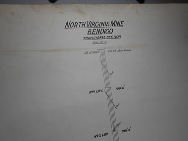 Bendigo Historical Society Inc.
Administrative record - North Virginia Mine Bendigo Transverse Section
... North Virginia Mine Bendigo Transverse Section...Draftsman's drawing North Virginia Mine Transverse Section Map. Forms part of the Margaret Roberts Collection of mining records....Administrative record North Virginia Mine Bendigo Transverse Section ...Draftsman's drawing North Virginia Mine Transverse Section Map. Forms part of the Margaret Roberts Collection of mining records.bendigo, margaret roberts, gold, map, mine, north virginia mine bendigo -
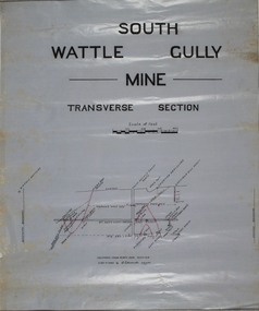 Bendigo Historical Society Inc.
Map - South Wattle Gully Co
... Written on top of plan: South Wattle Gully Mine, Transverse Section. Plan forms part of the Margaret Roberts Collection of mining records. ...Written on top of plan: South Wattle Gully Mine, Transverse Section. Plan forms part of the Margaret Roberts Collection of mining records. ...Plan drawn on wax paper. Written on top of plan: South Wattle Gully Mine, Transverse Section. Plan forms part of the Margaret Roberts Collection of mining records. margaret roberts, gold, chewton, shaft, south wattle gully co, gold mine -
 Bendigo Historical Society Inc.
Administrative record - Central Blue Section
... Mine...Central Blue Section...Draftsman's drawing Central Blue Section Mine Map. Forms part of the Margaret Roberts Collection of mining records....Bendigo Margaret Roberts gold Map Mine Central Blue Section Draftsman's drawing Central Blue Section Mine Map. ...Draftsman's drawing Central Blue Section Mine Map. Forms part of the Margaret Roberts Collection of mining records.bendigo, margaret roberts, gold, map, mine, central blue section -
Stawell Historical Society Inc
Map, Underground Survey of the Principal Mines of Stawell 1879, 1879
... Very large Map on cloth backing, showing cross sections of mines....Scales 120 feet to an inch Very large Map on cloth backing, showing cross sections of mines. Underground Survey of the Principal Mines of Stawell 1879 Map ...Pleasant Creek & Newington, Prince Patrick, Prince Alfred, Pioneer and Galatea, Pleasant Creek Cross Reef No. 1&2, Magdala, Old Shaft, Extended Cross Reef, Crown Cross, Great Northern, Sloanes & Scotchmans, South Cross, 10 & 11 United Scotchmans South Cross, Scotchmans Shafts, North Scothmans, West Scotchmans, Emerald Isle & Rose of Denmark, Albion, South Scotchmans, Newington & Pleasant Creek, Pleasant Creek Cross Reef, Moonlight, Extended Cross Reef, Crown cross United, Great Northern ShaftVery large Map on cloth backing, showing cross sections of mines.Surveyed by H.C. Bates. Drawn by Arthur Edwards. October 30th 1879. Scales 120 feet to an inchmining, gold -
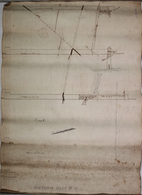 Bendigo Historical Society Inc.
Plan - Victoria Reef Gold Mine Trans Section
... Victoria Reef Gold Mine Trans Section...Hand drawn plan of Victoria Reef Gold Mine, trans section. Written on bottom of plan: Victoria Reef G.M.C. ...section of plan. Plan forms part of the Margaret Roberts Collection. Plan Victoria Reef Gold Mine Trans Section ...Victoria Reef Gold Mine was situated near the intersection of Hercules and Syncline Court, Long Gully.Hand drawn plan of Victoria Reef Gold Mine, trans section. Written on bottom of plan: Victoria Reef G.M.C. Handwritten annotations on section of plan. Plan forms part of the Margaret Roberts Collection.J. Sheard, 189 View Street, Bendigo' written on plangold mining, gold, victoria reef, trans section, bendigo, quartz mining -
 Bendigo Historical Society Inc.
Plan - Pearl Gold Mine shafts
... Drawn on paper with black pen, written on top of plan 'Pearl MIne transverse section, New Chum and Sheepshead Reef lines of reef' Plan forms part of the Margaret Roberts Collection of mining records. ...Margaret Roberts gold gold mine Bendigo Pearl Gold Mine Stone Street Long Gully Drawn on paper with black pen, written on top of plan 'Pearl MIne transverse section, New Chum and Sheepshead Reef lines of reef' Plan forms part of the Margaret Roberts Collection of mining records. ...The Pearl Gold Mine was near Stone Street, Long Gully.Drawn on paper with black pen, written on top of plan 'Pearl MIne transverse section, New Chum and Sheepshead Reef lines of reef' Plan forms part of the Margaret Roberts Collection of mining records. margaret roberts, gold, gold mine, bendigo, pearl gold mine, stone street, long gully -
 Bendigo Historical Society Inc.
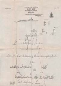
Map - STRUGNELL COLLECTION: HUSTLER'S LINE OF REEFS, BENDIGO, September 1913
... Map, Hustler's Line of Reefs, Comet Mine, Transverse Section, Plate No.XXV (25). Bulletin No 33 Signed H.A.Whitelaw. ...Map, Hustler's Line of Reefs, Comet Mine, Transverse Section, Plate No.XXV (25). Bulletin No 33 Signed H.A.Whitelaw. ...Map, Hustler's Line of Reefs, Comet Mine, Transverse Section, Plate No.XXV (25). Bulletin No 33 Signed H.A.Whitelaw. Drawing shows the vertical shaft descending to over 1692 feet and appears to show samples of connecting horizontal shafts with their respective mineral contentsUnderground Survey Office, Bendigo.map, bendigo, comet mine -
 Bendigo Historical Society Inc.
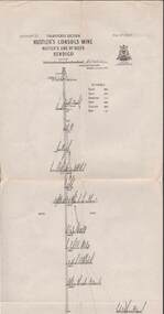
Map - STRUGNELL COLLECTION: HUSTLER'S LINE OF REEFS, September 1913
... Map, Hustler's Line of Reefs, Hustler's Consols Mine, Transverse Section, Bendigo.Plate no. XXX111 (33).Bulletin No 33 Signed H.A.Whitelaw. ...Map, Hustler's Line of Reefs, Hustler's Consols Mine, Transverse Section, Bendigo.Plate no. XXX111 (33).Bulletin No 33 Signed H.A.Whitelaw. ...Map, Hustler's Line of Reefs, Hustler's Consols Mine, Transverse Section, Bendigo.Plate no. XXX111 (33).Bulletin No 33 Signed H.A.Whitelaw. Drawing shows the vertical shaft descending to over 1326 feet and appears to show samples of connecting horizontal shafts with their respective mineral contentsUnderground Survey Office, Bendigo.map, bendigo, hustler's consols mine -
 Bendigo Historical Society Inc.
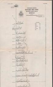
Map - STRUGNELL COLLECTION: HUSTLER'S LINE OF REEFS, September 1913
... Map, Hustler's Line of Reefs, Hustler's Reef Mine, Transverse Section, Bendigo. Plate No. XV111 (18).Bulletin No 33 Signed, H.A.Whitelaw. ...Map, Hustler's Line of Reefs, Hustler's Reef Mine, Transverse Section, Bendigo. Plate No. XV111 (18).Bulletin No 33 Signed, H.A.Whitelaw. ...Map, Hustler's Line of Reefs, Hustler's Reef Mine, Transverse Section, Bendigo. Plate No. XV111 (18).Bulletin No 33 Signed, H.A.Whitelaw. Drawing shows the vertical shaft descending to over 2195 feet and appears to show samples of connecting horizontal shafts with their respective mineral contentsUnderground Survey Office, Bendigo.map, bendigo, hustler's reef mine -
 Bendigo Historical Society Inc.
Map - STRUGNELL COLLECTION: HUSTLER'S LINE OF REEFS, BENDIGO, September 1913
... Map, Hustler's Line of Reefs, Great Extended Hustler's Mine, Longitudinal Section Plate No X111 (13). Bulletin No 33 Signed H.A.Whitelaw Underground survey Office Bendigo September 1913 Drawing shows mine shaft to over 3454 feet deep and appears to show samples of connecting horizontal shafts...Map, Hustler's Line of Reefs, Great Extended Hustler's Mine, Longitudinal Section Plate No X111 (13). Bulletin No 33 Signed H.A.Whitelaw Underground survey Office Bendigo September 1913 Drawing shows mine shaft to over 3454 feet deep and appears to show samples of connecting horizontal shafts Map STRUGNELL COLLECTION: HUSTLER'S LINE OF REEFS, BENDIGO. ...Map, Hustler's Line of Reefs, Great Extended Hustler's Mine, Longitudinal Section Plate No X111 (13). Bulletin No 33 Signed H.A.Whitelaw Underground survey Office Bendigo September 1913 Drawing shows mine shaft to over 3454 feet deep and appears to show samples of connecting horizontal shaftsUnderground Survey Office, Bendigo.map, bendigo, great extended hustler's mine -
 Bendigo Historical Society Inc.
Map - STRUGNELL COLLECTION: HUSTLER'S LINE OF REEF, BENDIGO
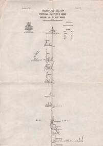
... Map, Hustler's Line of Reef, Bendigo, Fortuna Hustler's Mine, Longitudinal Section. Plate No. 1V (4). NOTE--- Plates 4,8,13,29,26 & 31 form a Longitudinal Section from Fortuna Hustler's to Hustler's Consols Mine.Bulletin No 33 Signed H.A.Whitelaw. ...Map, Hustler's Line of Reef, Bendigo, Fortuna Hustler's Mine, Longitudinal Section. Plate No. 1V (4). NOTE--- Plates 4,8,13,29,26 & 31 form a Longitudinal Section from Fortuna Hustler's to Hustler's Consols Mine.Bulletin No 33 Signed H.A.Whitelaw. ...Map, Hustler's Line of Reef, Bendigo, Fortuna Hustler's Mine, Longitudinal Section. Plate No. 1V (4). NOTE--- Plates 4,8,13,29,26 & 31 form a Longitudinal Section from Fortuna Hustler's to Hustler's Consols Mine.Bulletin No 33 Signed H.A.Whitelaw. Drawing shows the vertical shaft descending to over 2228 feetUnderground Survey Office, Bendigo.map, bendigo, fortuna hustler's mine -
 Bendigo Historical Society Inc.
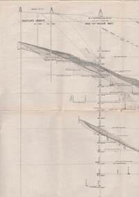
Map - STRUGNELL COLLECTION: UNITED HUSTLER'S & REDAN MINE, September 1913
... Map, United Hustler's & Redan Mine, Transverse Section, Hustler's Line of Reefs, Bendigo. ...History House 11 Mackenzie Street Bendigo goldfields MAP Bendigo hustler's & redan mine Underground Survey Office Map, United Hustler's & Redan Mine, Transverse Section, Hustler's Line of Reefs, Bendigo. ...Map, United Hustler's & Redan Mine, Transverse Section, Hustler's Line of Reefs, Bendigo. Plate No. XX1X (29).Bulletin No 33 Signed H.A.Whitelaw. Drawing shows the vertical shaft descending to over 1805 feet and appears to show samples of connecting horizontal shafts with their respective mineral contents. One level shows respective water levels .Underground Survey Officemap, bendigo, hustler's & redan mine -
 Bendigo Historical Society Inc.
Document - TAMBOUR MAJOR MINE
... Subject: Bendigo Major Mine, transverse section....Subject: Bendigo Major Mine, transverse section. Document TAMBOUR MAJOR MINE ...Six page document describing resources found in a search for 'Tambour major' and 'Mine' with Informit databaxse, VPI&E (formerly ELIXIR) and AESIS Databases. For example, record 1: Author Caldwell, J.J. Melbourne Geological Survey of Victoria 1946 3 figs, 3 microfiche frames, 2 negatives. Subject: Bendigo Major Mine, transverse section.bendigo, mining, tambour major -
 Bendigo Historical Society Inc.
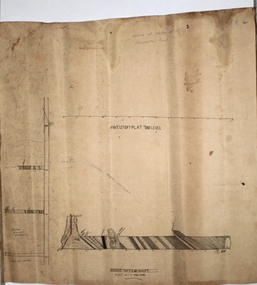
Map - Tambour Major Gold Mine
... Written on top of plan: Tambour Major Mine, Transverse Section, 100 ft to 1". 11469 tons yielded 3800 oz gold. ...Written on top of plan: Tambour Major Mine, Transverse Section, 100 ft to 1". 11469 tons yielded 3800 oz gold. ...Tambour Major Gold Mine was located in Specimen Hill, closest intersection: Specimen Hill and Marong Roads. Plan drawn on tan paper: transverse section of Tambour Major Mine, showing main shaft, Christmas Reef anticlinal axis line and fault line. Written on top of plan: Tambour Major Mine, Transverse Section, 100 ft to 1". 11469 tons yielded 3800 oz gold. Plan forms part of the Margaret Roberts Collection.gold mining, gold, bendigo, tambour major gold mine, specimen hill -
 Bendigo Historical Society Inc.
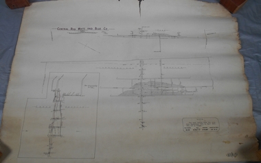
Map - Central Red White and Blue Co, 1913
... Hand drawn plan of Central Red, White and Blue Mine. Cross section and longitudinal plan drawn on plan. ...That the Lansell Estate did not acquire this property on its becoming available is puzzling in the light of the fact that in Eadie's day the late Mr G W Lansell, on discovering auriferous spurs in the south shaft (now the Central Blue) had offered 2,000 pounds for, and a percentage of gold won from the lease. https://search.informit.org/doi/10.3316/aesis.200105326 Bendigo Margaret Roberts gold Central Red White and Blue Gold Mine Map Margaret Roberts Collection Hand drawn plan of Central Red, White and Blue Mine. Cross section and longitudinal plan drawn on plan. ...The Central Red White and Blue Gold Mine was Bendigo's leading gold mine from 1910 - 1913. During the mine's operation, the main shaft was sunk 670 metres, and retrieved over 2500KG of gold. The Central Red White and Blue Gold Mine was located on the corner of Chum St and Honeysuckle St in Golden Square.. During the mine's operation, the main shaft was sunk 670 metres, and retrieved over 2500KG of gold. The registration of the Company in 1891 (Government Gazette 138, November 6th. 1891, page 4465) lists the value of the Company's property as three hundred and fifty pounds. The number of shares was thirty thousand at 2 shillings each. The Manager was Mr. William Weeks Barker. Ref: https://gazette.slv.vic.gov.au/view.cgi?year=1891&class=general&page_num=4465&state=v&classnum=g138&id= Extract from Whitelaw Report: Central Red White and Blue Mine, Bendigo. Author: H E Whitelaw Abstract Early in 1910, some considerable time after it had become generally known that a rich reef at a depth of 405 ft was being worked southward from the privately owned Lansell's Little 180 shaft and immediately following the plotting of the Geological Survey pitch diagram of the Sheepshead line of reefs, some wide awake local mining men seized the opportunity to secure the holding known as Eadie's which, overlapping Lansell's lease and containing a stretch of the Sheepshead reef channel between the Little 180 north and south shafts, had been declared void some five years previously. That the Lansell Estate did not acquire this property on its becoming available is puzzling in the light of the fact that in Eadie's day the late Mr G W Lansell, on discovering auriferous spurs in the south shaft (now the Central Blue) had offered 2,000 pounds for, and a percentage of gold won from the lease. https://search.informit.org/doi/10.3316/aesis.200105326 Hand drawn plan of Central Red, White and Blue Mine. Cross section and longitudinal plan drawn on plan. Printed name on top of plan: 'Central Red White and Blue Co' Plan printed by Troedel & Cooper Pty Ltd. Surveyor W. H. Cundy, Bendigo April 1913 Plan is part of the Margaret Roberts Collection of mining records.bendigo, margaret roberts, gold, central red white and blue gold mine, map, margaret roberts collection -
 Bendigo Historical Society Inc.
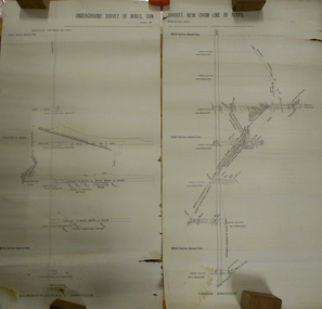
Document - MARKS COLLECTION: UNDERGROUND SURVEY OF MINES NEW CHUM LINE OF REEFS
... Shows cross section of mine, b. longitudinal section. Drawn by Arthur Everett, Mining Department, Melbourne 1884. ...Shows cross section of mine, b. longitudinal section. Drawn by Arthur Everett, Mining Department, Melbourne 1884. ...Plan, in two sections, on heavy parchment coloured paper. Printed across top in black ink 'Underground Survey of Mines New Chum Line of Reefs' a. Shows cross section of mine, b. longitudinal section. Drawn by Arthur Everett, Mining Department, Melbourne 1884. Surveyed by Caleb Thomas under the direction of Charles Langtree. Plan found in George Lansell auction items. Plan found in George Lansell items sold at auction.bendigo, mining, new chum reef -
Bendigo Historical Society Inc.
Photograph - AUSTIN COLLECTION: Wattle Gully Gold Mine, Chewton, 1982
... Black and white photograph: Four miners exiting a mine shaft cage on the surface at Williams United Gold Mine, Eaglehawk. Top section of cage visible in background of image. ...Gold Mining underground Williams United Gold Mine Eaglehawk Western Mining GMC timbering Black and white photograph: Four miners exiting a mine shaft cage on the surface at Williams United Gold Mine, Eaglehawk. Top section of cage visible in background of image. ...Black and white photograph: Four miners exiting a mine shaft cage on the surface at Williams United Gold Mine, Eaglehawk. Top section of cage visible in background of image. One miner still standing in cage. MIner with beard is Dale Williams.gold mining, underground, williams united gold mine, eaglehawk, western mining gmc, timbering -
 Bendigo Historical Society Inc.
Plan - Prince of Wales No. 2 shaft
... Drawn on paper, plan shows cross section of mine workings. Written in pencil on top of plan 'Prince of Wales No. 2'. ...Margaret Roberts gold gold mine Bendigo Prince of Wales No. 2 Gold Mine Williams Road Hopkins Avenue Drawn on paper, plan shows cross section of mine workings. ...Princ e of Wales No. 2 shaft was located approx.130 metres west of the corner of Williams Road and Hopkins Avenue, Eaglehawk. Drawn on paper, plan shows cross section of mine workings. Written in pencil on top of plan 'Prince of Wales No. 2'. Plan forms part of the Margaret Roberts Collection of mining records. margaret roberts, gold, gold mine, bendigo, prince of wales no. 2 gold mine, williams road, hopkins avenue -
 Federation University Historical Collection
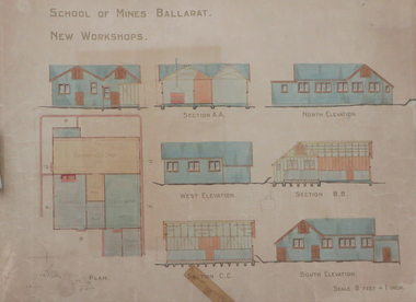
Plan, Ballarat School of Mines New Workshops, 1912, 08/1912
... Original plan for new workshops for the Ballarat School of Mines. Includes elevations and sections, abd has been coloured with watercolour. ...ballarat school of mines new workshops carpentry blacksmithing plumbing architectural plan laboratory Original plan for new workshops for the Ballarat School of Mines. Includes elevations and sections, abd has been coloured with watercolour. ...Original plan for new workshops for the Ballarat School of Mines. Includes elevations and sections, abd has been coloured with watercolour. The new workshops housed carpenters shop, plumbers, blacksmihing and stores. ballarat school of mines, new workshops, carpentry, blacksmithing, plumbing, architectural plan, laboratory -
 Bendigo Historical Society Inc.
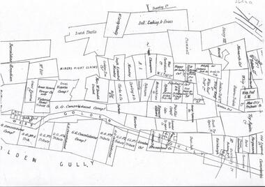
Plan - GOLDEN GULLY CLAIMHOLDERS
... Plan showing names of claimholders in Golden Gully ( part section only). Mines include Glasgow Golconda Consolidated Company, GG Tribute, Victoria Console, Try Again, Bell, Cocking and Evans....History House 11 Mackenzie Street Bendigo goldfields BHS Collection BENDIGO Mining golden gully Plan showing names of claimholders in Golden Gully ( part section only). Mines include Glasgow Golconda Consolidated Company, GG Tribute, Victoria Console, Try Again, Bell, Cocking and Evans. ...BHS CollectionPlan showing names of claimholders in Golden Gully ( part section only). Mines include Glasgow Golconda Consolidated Company, GG Tribute, Victoria Console, Try Again, Bell, Cocking and Evans.bendigo, mining, golden gully -
 Bendigo Historical Society Inc.
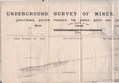
Map - STRUGNELL COLLECTION: NEW CHUM LINE OF REEF, 5/4/01
... Map, Along portion of the New Chum Line, Underground Survey of Mines, Bendigo, Longitudinal Section through the Saddle Reefs and Centre Country. ...History House 11 Mackenzie Street Bendigo goldfields MAP Bendigo new chum line H.S.Whitelow Map, Along portion of the New Chum Line, Underground Survey of Mines, Bendigo, Longitudinal Section through the Saddle Reefs and Centre Country. ...Map, Along portion of the New Chum Line, Underground Survey of Mines, Bendigo, Longitudinal Section through the Saddle Reefs and Centre Country. Eureka Extended Co's shaft, New Chum Railway Co's shaft. Surveyed under the supervision of H.Herman, B.C.E., F.G.S., Acting Government Geologist.H.S.Whitelowmap, bendigo, new chum line -
 Bendigo Historical Society Inc.
Map - STRUGNELL COLLECTION: HUSTLER'S LINE OF REEFS, BENDIGO, September 1913
... Map, Hustler's Line of Reefs, Fortuna Hustler's Mine, Bendigo, Transverse Section. Plate Mo.111(3).Bulletin No 33 Signed H.A.Whitelaw. ...Map, Hustler's Line of Reefs, Fortuna Hustler's Mine, Bendigo, Transverse Section. Plate Mo.111(3).Bulletin No 33 Signed H.A.Whitelaw. ...Map, Hustler's Line of Reefs, Fortuna Hustler's Mine, Bendigo, Transverse Section. Plate Mo.111(3).Bulletin No 33 Signed H.A.Whitelaw. Drawing shows the vertical shaft descending to over 2228 feet and appears to show samples of connecting horizontal shafts with their respective mineral contentsUnderground Survey Office, Bendigo.map, bendigo, fortuna hustler's mine -
 Bendigo Historical Society Inc.
Map - Geological survey of Bendigo Goldfields
... The three sections are Eaglehawk, Golden Square and Spring Gully. It shows geological conditions, gold reef lines and mine sights. ...The three sections are Eaglehawk, Golden Square and Spring Gully. It shows geological conditions, gold reef lines and mine sights. ...Three Geological survey maps of the Bendigo Gold Fields joined together. The three sections are Eaglehawk, Golden Square and Spring Gully. It shows geological conditions, gold reef lines and mine sights. Three sections are laminated together. The maps were produced by the Victorian Department of Manufacturing and Industry Development geological survey, bendigo gold fields -
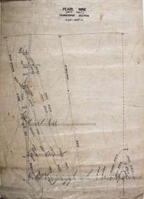 Bendigo Historical Society Inc.
Plan - Pearl Gold Mine
... Mine...Stone Street...Long Gully...south shaft...transverse section...Written on top of plan 'Pearl Mine, south shaft, transverse section, Scale 100 ft = 1 inch'. ...Written on top of plan 'Pearl Mine, south shaft, transverse section, Scale 100 ft = 1 inch'. ...The Pearl Gold Mine was near Stone Street, Long Gully.Drawn on paper with black pen. Written on top of plan 'Pearl Mine, south shaft, transverse section, Scale 100 ft = 1 inch'. Plan forms part of the Margaret Roberts Collection of mining records. margaret roberts, gold, gold mine, bendigo, pearl gold mine, stone street, long gully, south shaft, transverse section