Showing 106 items matching mining camps
-
 Federation University Historical Collection
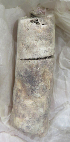
Object - Candle Remnant, Candle remnant from early Two Ballarat mines, c1860 ?
From the Britannia Mine (Ballarat) Candle remnants from early Ballarat mines are quite rare..1) White/cream candle remnant. Candle mold seams are evident. Stored in green pharmaceutical tin with screw lid. (?) Found when removing for filling motor spaces Camp Street. .2) white candle remnant from the Britannia Mine at Cambrian Hill held in a 'Barker Cake Container; tin. A handwritten note inside the tin indicates 'Piece of Candle from Mullock's Britannia Mine. Ballarat. .2) Piece of Candle The Great Leviathan Quartz Mining CosMine at Cambrian Hill near Ballarat. Picked up by Donald Doyles Mather whilst cleaning out Ballarat South Goldfield Co's Leviathan Shaft when reopening "Great Leviathan in in the year 1948. The candle was last used by miners in the Great Leviathan in the drive where found Year G. Leviathan Closed down "______" mining, candle, lard, great leviathan, donald mather, cambrian hill, great leviathan quartz mining company -
 Marysville & District Historical Society
Article (item) - Book Extract, Aboriginal History, Unknown
An extract from a book regarding a brief history of the Kulin nation of the North Central district of Victoria.An extract from a book regarding a brief history of the Kulin nation of the North Central district of Victoria. This history covered is both prior to European history and post-European history. The extract also covers current (1991) status of Aboriginal affairs and European settlement of the area.kulin nation, woiworung, taungurong, bunurong, watherong, jajowrong, wurrundjeri-willam, waring-ilam-balluk, goulburn valley, acheron valley, upper goulburn district, eildon-thornton, eildon homestead, o'rourke, thornton, assistant protector thomas, yarra valley, kilmore, mount william, jt gellibrand, william buckley, major mitchell, port phillip, murray river, yorta yorta, yowung-illam-balluk, waring-illam-balluk, ngurai-illam-wurrung, kurnai nation, protectorate system, victoria, george robinson, chief protector, willam thomas, james dredge, edward parker, charles sievewright, central board for the protection of aborigines, presbyterian mission, anglican mission, moravian mission, wonga, munnarin, beaning, murrin murrin, parugean, baruppin, koo-gurrin, acheron river, little river, acheron run, peter snodgrass, stephen jones, barak, dividing range, black spur, watts river, badger creek, healesville, coranderrk, victorian christmas bush, aboriginal and torres strait islander heritage protection act 1984, archaelological and aboriginal relics preservation act 1972, camp jungai, rubicon, warrawa college, victorian archaeological survey, hume and hovell, molesworth, broadford, william hamilton, alexandra, mansfield, avenel, tallarook, worrough, john cotton, trawool valley, seymour, pyalong, gold mining, central victoria, strath creek, reedy creek, yea, jamieson, marysville, jordan goldfields, comet mine, wandong, melbourne-albury railway, rabbit plague, narbethong, lord kitchener, puckapunyal military camp, 1944 decentralisation policy, eildon weir, hume freeway bypass, timber industry, australian paper manufacturers mill -
 Marysville & District Historical Society
Photograph (item) - Black and white photograph, Unknown
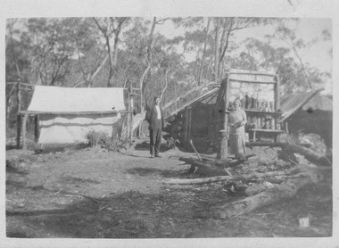
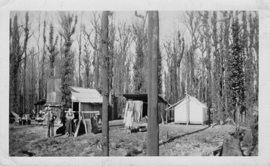
An early black and white photograph of the Golden Bower mine camp in the Cumberland Valley in Victoria.An early black and white photograph taken at the Golden Bower Mine in the Cumberland Valley in Victoria. The Golden Bower gold mine was a quartz reef mine. William Edward Chester discovered the Golden Secret gold vein which became part of the Golden Bower Mine at Chesterville near Donovans Creek on the Cumberland goldfield which he mined with George Locke until the late 1930s. golden bower gold mine, cumberland valley, victoria, quartz reef mining, water-powered battery, william edward chester, george locke, chesterville, donovan's creek, cumberland goldfield -
 Marysville & District Historical Society
Photograph (item) - Black and white photograph, Unknown
An early black and white photograph taken at the Golden Bower Mine Camp in the Cumberland Valley in Victoria.An early black and white photograph taken at the Golden Bower Mine in the Cumberland Valley in Victoria. The Golden Bower gold mine was a quartz reef mine. William Edward Chester discovered the Golden Secret gold vein which became part of the Golden Bower Mine at Chesterville near Donovans Creek on the Cumberland goldfield which he mined with George Locke until the late 1930s. golden bower gold mine, cumberland valley, victoria, quartz reef mining, water-powered battery, william edward chester, george locke, chesterville, donovan's creek, cumberland goldfield -
 Marysville & District Historical Society
Postcard (item) - Black and white postcard, Unknown
An early black and white photograph taken at the Golden Bower Mine Camp in the Cumberland Valley in Victoria.An early black and white photograph taken at the Golden Bower Mine Camp in the Cumberland Valley in Victoria. The Golden Bower gold mine was a quartz reef mine. William Edward Chester discovered the Golden Secret gold vein which became part of the Golden Bower Mine at Chesterville near Donovans Creek on the Cumberland goldfield which he mined with George Locke until the late 1930s. POST CARD CORRESPONDENCE. ADDRESS ONLY. KODAK/ AUSTRALIA 30/06/10 Rose Hill/ Fitzwilliam Street/ Kew Should have written/ to you months ago about the/ photos I took at Easter./ Sorry to say the one of the little/ girls was no good I expect/ you will recognise both these/ places/ K McDowell Mrs Fletcher/ Golden Bower Mine/ Via Marysville J Mahoneygolden bower gold mine, cumberland valley, victoria, quartz reef mining, water-powered battery, william edward chester, george locke, chesterville, donovan's creek, cumberland goldfield -
 Marysville & District Historical Society
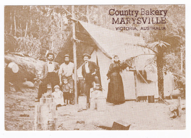
Postcard (item) - Black and white postcard, George Symons, Country Bakery, MARYSVILLE, VICTORIA, AUSTRALIA, 1990's
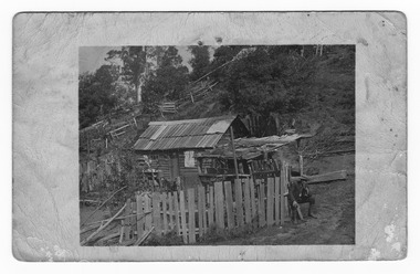
An early photograph of a miner and his family standing outside their tent in the Australian bush.An early sepia photograph of a miner and his family standing outside their tent in the Australian bush. This postcard was produced by George Symons as a souvenir of Marysville.AUSTRALIAN/ yesteryear/ CARDS P7 CORRESPONDENCE ADDRESS IN THEIR SUNDAY BEST c. 1880 A miner's family dressed in their Sunday best/ outside their tent dwelling./ Despite the difficulties of tent life the woman/ has brought her touch to the camp and is still/ able to dress her family immaculately for their/ Sunday stroll down the track. Photographer Unknown A sepia tone facsimile of/ an early Australian photographmarysville, victoria, mining life, australia, george symons, postcard, souvenir -
Federation University Historical Collection
Book - Course Guide, University of Ballarat Program Guide 2012/13, 2012
Couloured cover, predominantly in ochre, with a young man's face featuring. Contents include: Applications. Deferring. VTAC, fees, financial assistance, scholarships, TAFE, Campuses, Exchange Universities, Stawell Campus, Camp Street Campus, Arts Academy, SMB Campus, Mt Helen Campus, Ararat Campus, Horsham Campus, UB Tec, Student Experience office, Student Living Skills, Aboriginal Education Centre, Student Learning Skills, Conselling, UB PASS, UB Ready, SMB Fitness Centre, Disability, Helat Services, Alumni, Gold Key Chapter, Student Res, idences, apprenticeships, traineeships, unisports, ceramics, acting, teaching, nursing, human movement, Nick Driden, engineering, geology, mining, equineapplications. deferring. vtac, fees, financial assistance, scholarships, tafe, campuses, exchange universities, stawell campus, camp street campus, arts academy, smb campus, mt helen campus, ararat campus, horsham campus, ub tec, student experience office, student living skills, aboriginal education centre, student learning skills, conselling, ub pass, ub ready, smb fitness centre, disability, helat services, alumni, gold key chapter, student res, idences, apprenticeships, traineeships, unisports, ceramics, acting, teaching, nursing, human movement, nick driden, engineering, geology, mining, equine, courses, handbook -
 Kiewa Valley Historical Society
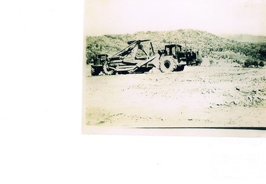
Photograph Tournapull, Tournapull C Scraper/Single Bucket, circa 1950
The machinery in this photo shows a Tournapull C earth moving machine, one of many during this period Circa 1950 - 1960s when hydro electricity powered turbines were being constructed in both the Victoria and New South Wales Alps. This was Australia's answer to a non polluting supply of electricity for a fast growing city population. It was at this time that air pollution from coal powered furnaces was becoming more and more under attack by health authorities.This item is part of a visual account of the construction of dams and hydro electricity facilities during the early 1950s. It was the beginning of the environmental push not to allow the degrading of Australian Alpine regions. Air pollution of the major cities and the increase in power demands of both industries and population within them required an alternative pollution free alternative electricity supply. These for runners of Hydro electricity generators required both large supplies of machinery and human resources. This construction phase within the region brought not only tradesmen but also unskilled workers to an area which had mainly had farming and mining activities. It was the catalyst for the creation of the smaller towns/villages e.g. Bogong Village, Mount Beauty and Bright.Black and white photograph on Kodak Xtralite II paper.(gloss)paper marking on back Kodak Xtralite II papermining, hydro electricity, victorian alps, construction camps, earth moving machines, secv -
 Kiewa Valley Historical Society
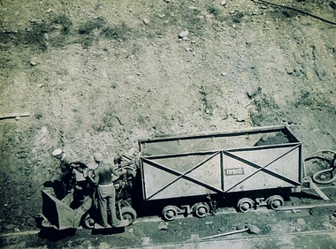
Photograph Shovel Truck, Shovel Loading Rail Truck, circa 1950s
This item shows the excavation of the side of a railway track using a pneumatic shovel and a rail mounted truck by two workmen. The period covered was well before State Health and Safety requirements, such as helmets, became law. It also details that the workmen were from European heritage as their head coverings were a handkerchief knotted at each corner. This was typical for workmen of this heritage, others used caps or hats or no head covering at all (the macho male look)The photograph of this item was one of many depicting great achievements and opening up the region. A visual link or time capsule of the 1950s rural/mining sectors clashing with the established rural industriesThis photo depicts the time (1950's) and place (Bogong and Mount Beauty) where construction workers had an immense impact, not only on the physical environment but also on the social and economic development of the Victorian Alps region. The fast expansion of smaller settlements brought about increased pressures on the welfare viability of certain subgroups within the region e.g. farming, droving and commerce (caravan hawkers versus static shops). These changes brought about a heightened awareness by both local and State Governments to upgrade not only facilities within the region but also access to the region. Black and white photo of two workmen on a rail mounted shovel truck. The photo is of good definition allowing a clear view of the subject matter. The paper is semi gloss.On the back of the photo, paper suppliers etchings are "Kodak XtraLife II paper"mining, hydro electricity, victorian alps, construction camps, earth moving machines -
 The Beechworth Burke Museum
Photograph, est. 1860-1875
In 1875, the Rocky Mountain Extended Gold Sluicing Company Ltd was created, utilising the previous Rocky Mountain claim for the area near Lake Sambell. The company employed A.L Martin to survey an area for a tunnel underneath Beechworth and Johnson Stephens to dig it. The tunnel was built at a rate of 40 feet a month and eventually measured 800 metres. The tunnel was a true accomplishment both in the present and during the 19th century. It was considered to be a marvelous engineering feat. Beechworth is renowned for its hydraulic sluice method of mining. This involved soil being exposed to torrents of water from high-pressure hoses. From 1876 until its closure in 1921, the mine produced an astounding 47,926 ozs of gold. Companies like this were the source of income for many Chinese gold-diggers who sought to make their fortune on the goldfields of Beechworth. During the height of the rush, the town had around 7,000 Chinese inhabitants living on the outskirts of town as they were not permitted to live within Beechworth itself.The search for gold is ingrained into the history of Victoria and therefore, images like this one which portrays an open-cut sluicing site can reveal important information for society and technology for the date when the photograph was taken. This image is of important historical significance for its ability to convey information about sluicing and the methods used to find gold in 1910. It also shows a location where sluicing was undertaken which provides insight into the impact of sluicing on the environment at a time when it was done. This image of the Rocky Mountain mine is historically significant as the mining complex is now non-existent, with the only remains being the tunnel built in 1880 by the company, which was considered one of the greatest engineering feats of the time. The image also provides a first-hand look into the social and cultural networks at play during the 19th century with racial segregation of the Chinese at the 'Chinese Camp', as well as an insight into Beechworth's origins during the Gold Rush.A sepia rectangular photograph printed on matte photographic paper as a postcardReverse: Historic Beechworth / 7792.1 / ROCKY MOUNTAIN MINE / Viewed from the “Chinese Camp”, shown partly in the foreground, we see the central plant of the famous Rocky Mountain Mining Company. This extensive complex, of which nothing remains, was situated between Silver Creek and the present Lake Sambell area. The company was responsible for a tunnel cut through solid bedrock underneath the town of Beechworth and surfacing near the keystone bridge on the Wangaratta side. Completed in 1880 it was declared to be one of the greatest engineering feats in Australia. The tunnel is still basically intact today. / Series by Wooragee Graphics: Historic Beechworth. / COPYRIGHT BURKE MUSEUM / No.72 beechworth, rocky mountain mine, sluicing, gold rush, mining, gold -
 The Beechworth Burke Museum
Photograph, c1930
Taken on 25 October 1930, various houses with the Hume Dam under construction are depicted in the background. The construction of the Hume Dam took place from 1919 to 1936. At the time of construction, it was the second largest dam in the world. It was also one of the earliest civil projects developed after the Federation. Some of the Dam workers consisted of World War I veterans. Dam workers often settled their families in Mitta Junction Village and Wodonga. Archaeological surveys were completed by Austral Archaeology, which was done when the Department of Land & Water Conservation was doing work to improve Hume Dam. The archaeological report that came out of the survey recommended three sites of interest where archaeological excavation should be done: Camp Ganger’s Quarters, Stableman’s Quarters, and the Industrial Dump. The excavation uncovered artefacts. Mitta Mitta: Mitta Mitta is situated between Mount Welcome and Mount Misery. It is named after the river that explorers Hume and Hovell discovered in 1824. The town would eventually become a huge gold mining town. Mitta Mitta is called Midamodunga by the local Indigenous peoples Wodonga: Wodonga is situated on the Murray River and is part of North East Victoria. Hume and Hovell: Hamilton Hume (1979-1873) and William Hilton Hovell (1786-1875). W. H. Hovell was born in Norfolk England and Hume was born in Parramatta, New South Wales Hovell and Hume undertook an exploration journey in 1824 and thought they discovered a river, which turned out to be the Murray River. They returned home in 1825, but returned to the area in 1826 and discovered coal in the area. This photo is historically significant as it shows the Hume Dam under construction in 1930. The Dam was named after Hamilton Hume, who is an important historical figure for this area as he helped discover the area where resources were found.Sepia rectangular photograph printed unmountedReverse: 84-19-5 / 1997.3185/ Values & spillway. / When completed the wall / will be as high as the / scaffolding. [featuring trademark: kodak print]construction, houses, veterans, mitta junction village, hume dam, world war i, federation, wodonga, archaeological survey, excavation, austral archaeology, department of land & water conservation, camp ganger's quarter's, stableman's quarters, industrial dump, artefacts, mitta mitta, mount welcome, mount misery, murray river, hamilton hume, william hilton hovell, hume and hovell expedition -
 The Beechworth Burke Museum
Photograph, c1930
Taken on 25 October 1930, various houses with the Hume Dam under construction are depicted in the background. The construction of the Hume Dam took place from 1919 to 1936. At the time of construction, it was the second largest dam in the world. It was also one of the earliest civil projects developed after the Federation. Some of the Dam workers consisted of World War I veterans. Dam workers often settled their families in Mitta Junction Village and Wodonga. Archaeological surveys were completed by Austral Archaeology, which was done when the Department of Land & Water Conservation was doing work to improve Hume Dam. The archaeological report that came out of the survey recommended three sites of interest where archaeological excavation should be done: Camp Ganger’s Quarters, Stableman’s Quarters, and the Industrial Dump. The excavation uncovered artefacts. Mitta Mitta: Mitta Mitta is situated between Mount Welcome and Mount Misery. It is named after the river that explorers Hume and Hovell discovered in 1824. The town would eventually become a huge gold mining town. Mitta Mitta is called Midamodunga by the local Indigenous peoples Wodonga: Wodonga is situated on the Murray River and is part of North East Victoria. Hume and Hovell: Hamilton Hume (1979-1873) and William Hilton Hovell (1786-1875). W. H. Hovell was born in Norfolk England and Hume was born in Parramatta, New South Wales Hovell and Hume undertook an exploration journey in 1824 and thought they discovered a river, which turned out to be the Murray River. They returned home in 1825, but returned to the area in 1826 and discovered coal in the area.This photo is historically significant as it shows the Hume Dam under construction in 1930. The Dam was named after Hamilton Hume, who is an important historical figure for this area as he helped discover the area where resources were found.Sepia rectangular photograph printed unmountedReverse: 84-19-2/ 1997.3188/ These are the four / release valves they are / not always open (illegible) this / when closed the water flows / over the spillway. [featuring trademark: kodak print] photograph number: 354construction, houses, veterans, mitta junction village, hume dam, world war i, federation, wodonga, archaeological survey, excavation, austral archaeology, department of land & water conservation, camp ganger's quarter's, stableman's quarters, industrial dump, artefacts, mitta mitta, mount welcome, mount misery, murray river, hamilton hume, william hilton hovell, hume and hovell expedition -
 The Beechworth Burke Museum
Photograph, 25 October 1930
Taken on 25 October 1930, various houses with the Hume Dam under construction are depicted in the background. The construction of the Hume Dam took place from 1919 to 1936. At the time of construction, it was the second largest dam in the world. It was also one of the earliest civil projects developed after the Federation. Some of the Dam workers consisted of World War I veterans. Dam workers often settled their families in Mitta Junction Village and Wodonga. Archaeological surveys were completed by Austral Archaeology, which was done when the Department of Land & Water Conservation was doing work to improve Hume Dam. The archaeological report that came out of the survey recommended three sites of interest where archaeological excavation should be done: Camp Ganger’s Quarters, Stableman’s Quarters, and the Industrial Dump. The excavation uncovered artefacts. Mitta Mitta: Mitta Mitta is situated between Mount Welcome and Mount Misery. It is named after the river that explorers Hume and Hovell discovered in 1824. The town would eventually become a huge gold mining town. Mitta Mitta is called Midamodunga by the local Indigenous peoples Wodonga: Wodonga is situated on the Murray River and is part of North East Victoria. Hume and Hovell: Hamilton Hume (1979-1873) and William Hilton Hovell (1786-1875). W. H. Hovell was born in Norfolk England and Hume was born in Parramatta, New South Wales Hovell and Hume undertook an exploration journey in 1824 and thought they discovered a river, which turned out to be the Murray River. They returned home in 1825, but returned to the area in 1826 and discovered coal in the area.This photo is historically significant as it shows the Hume Dam under construction in 1930. The Dam was named after Hamilton Hume, who is an important historical figure for this area as he helped discover the area where resources were found.Sepia rectangular photograph printed unmountedReverse: 84-19-6/ 1997.3187/ The spillway [featuring trademark: kodak print] construction, houses, veterans, mitta junction village, hume dam, world war i, federation, wodonga, archaeological survey, excavation, austral archaeology, department of land & water conservation, camp ganger's quarter's, stableman's quarters, industrial dump, artefacts, mitta mitta, mount welcome, mount misery, murray river, hamilton hume, william hilton hovell, hume and hovell expedition -
 The Beechworth Burke Museum
Photograph, 25 October 1930
Taken on 25 October 1930, various houses with the Hume Dam under construction are depicted in the background. The construction of the Hume Dam took place from 1919 to 1936. At the time of construction, it was the second largest dam in the world. It was also one of the earliest civil projects developed after the Federation. Some of the Dam workers consisted of World War I veterans. Dam workers often settled their families in Mitta Junction Village and Wodonga. Archaeological surveys were completed by Austral Archaeology, which was done when the Department of Land & Water Conservation was doing work to improve Hume Dam. The archaeological report that came out of the survey recommended three sites of interest where archaeological excavation should be done: Camp Ganger’s Quarters, Stableman’s Quarters, and the Industrial Dump. The excavation uncovered artefacts. Mitta Mitta: Mitta Mitta is situated between Mount Welcome and Mount Misery. It is named after the river that explorers Hume and Hovell discovered in 1824. The town would eventually become a huge gold mining town. Mitta Mitta is called Midamodunga by the local Indigenous peoples Wodonga: Wodonga is situated on the Murray River and is part of North East Victoria. Hume and Hovell: Hamilton Hume (1979-1873) and William Hilton Hovell (1786-1875). W. H. Hovell was born in Norfolk England and Hume was born in Parramatta, New South Wales Hovell and Hume undertook an exploration journey in 1824 and thought they discovered a river, which turned out to be the Murray River. They returned home in 1825, but returned to the area in 1826 and discovered coal in the area.This photo is historically significant as it shows the Hume Dam under construction in 1930. The Dam was named after Hamilton Hume, who is an important historical figure for this area as he helped discover the area where resources were found.Black and white rectangular photograph printer unmountedReverse: 84-20-1/ 1997.3147construction, houses, veterans, mitta junction village, hume dam, world war i, federation, wodonga, archaeological survey, excavation, austral archaeology, department of land & water conservation, camp ganger's quarter's, stableman's quarters, industrial dump, artefacts, mitta mitta, mount welcome, mount misery, murray river, hamilton hume, william hilton hovell, hume and hovell expedition -
 The Beechworth Burke Museum
Photograph, 25 October 1930
Taken on 25 October 1930, various houses with the Hume Dam under construction are depicted in the background. The construction of the Hume Dam took place from 1919 to 1936. At the time of construction, it was the second largest dam in the world. It was also one of the earliest civil projects developed after the Federation. Some of the Dam workers consisted of World War I veterans. Dam workers often settled their families in Mitta Junction Village and Wodonga. Archaeological surveys were completed by Austral Archaeology, which was done when the Department of Land & Water Conservation was doing work to improve Hume Dam. The archaeological report that came out of the survey recommended three sites of interest where archaeological excavation should be done: Camp Ganger’s Quarters, Stableman’s Quarters, and the Industrial Dump. The excavation uncovered artefacts. Mitta Mitta: Mitta Mitta is situated between Mount Welcome and Mount Misery. It is named after the river that explorers Hume and Hovell discovered in 1824. The town would eventually become a huge gold mining town. Mitta Mitta is called Midamodunga by the local Indigenous peoples Wodonga: Wodonga is situated on the Murray River and is part of North East Victoria. Hume and Hovell: Hamilton Hume (1979-1873) and William Hilton Hovell (1786-1875). W. H. Hovell was born in Norfolk England and Hume was born in Parramatta, New South Wales Hovell and Hume undertook an exploration journey in 1824 and thought they discovered a river, which turned out to be the Murray River. They returned home in 1825, but returned to the area in 1826 and discovered coal in the area. This photo is historically significant as it shows the Hume Dam under construction in 1930. The Dam was named after Hamilton Hume, who is an important historical figure for this area as he helped discover the area where resources were found. Black and white rectangular photograph printer unmountedReverse: 1997.3145/ 84-20-2construction, houses, veterans, mitta junction village, hume dam, world war i, federation, wodonga, archaeological survey, excavation, austral archaeology, department of land & water conservation, camp ganger's quarter's, stableman's quarters, industrial dump, artefacts, mitta mitta, mount welcome, mount misery, murray river, hamilton hume, william hilton hovell, hume and hovell expedition -
 The Beechworth Burke Museum
Photograph - Photograph - Reproduction
The photograph is a reproduction of a postcard from the Rocky Mountain Mining Company. In 1875, the Rocky Mountain Extended Gold Sluicing Company Ltd was created, utilising the previous Rocky Mountain claim for the area near Lake Sambell. The company employed A.L Martin to survey an area for a tunnel underneath Beechworth and Johnson Stephens to dig it. The tunnel was built at a rate of 40 feet a month and eventually measured 800 metres. The tunnel was a true accomplishment both in the present and during the 19th century. It was considered to be a marvelous engineering feat. Beechworth is renowned for its hydraulic sluice method of mining. This involved soil being exposed to torrents of water from high-pressure hoses. From 1876 until its closure in 1921, the mine produced an astounding 47,926 ozs of gold. Companies like this were the source of income for many Chinese gold-diggers who sought to make their fortune on the goldfields of Beechworth. During the height of the rush, the town had around 7,000 Chinese inhabitants living on the outskirts of town as they were not permitted to live within Beechworth itself.This image of the Rocky Mountain mine is historically significant as the mining complex is now non-existent, with the only remains being the tunnel built in 1880 by the company, which was considered one of the greatest engineering feats of the time. The image also provides a first-hand look into the social and cultural networks at play during the 19th century with racial segregation of the Chinese at the 'Chinese Camp', as well as an insight into Beechworth's origins during the Gold Rush.Black and white rectangular reproduced photograph printed on paperbeechworth, rocky mountain mine, sluicing, gold rush, mining, gold -
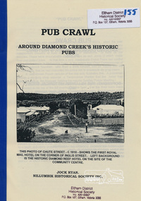 Eltham District Historical Society Inc
Book, Nillumbik Historical Society, Pub Crawl: around Diamond Creek's historic pubs by Jock Ryan, 2001
Hotels described include: Evelyn Arms Hotel or Tunnel Camp Hotel or Half-Way House, the Diamond Reef Hotel, the Loyal Diamond Lodge Hotel and the Royal Mail Hotel all located in Diamond Creek during a rapid population growth in Diamond Creek in the 1860s.This small publication discusses the history of local hotels in the Diamond Creek area during a significant period of development in the 1860s when mining took place in the local area. The history of hotels connects to the wider history and important social and civic link to the community at that time. [10] p. includes text and very poor photocopy reproductions of historical photographs. Perfect bound with plastic front cover only.EDHS Property stamp on front coverdiamond creek, hotels, pubs, bars, 1860s -
Kew Historical Society Inc
Book, Geoff Hocking, Castlemaine : from camp to city 1835-1900, a pictorial history of Forest Creek & the Mount Alexander goldfields, 1994
230 p. : ill. (some col.), facsims, maps, ports. ; 22 x 25 cm.non-fictiongold mines and mining -- victoria -- castlemaine -- history, castlemaine (vic.) -- history -
Tatura Irrigation & Wartime Camps Museum
Album - small photo album
The artist of the sketches Hans - Wolter von Gruenewaldt - ex South African Mining Engineer served in the North Africa campaign. This album also includes photos of visitors to the Tatura Museum, Memorial service German War Cemetery 1992 and visitors to Camps 1, 2, 4 and 13 Photos include Murchison R.S.L clubhouse,which was Murchison P.O.W Camp,13 Recreation Hall, Colonel Walter Tinsley D.S.O who was appointed Commandant camp 13 1946, Folk Dancers from Hungary,Scotland, Yugoslavia, Russia, Spain, Holland, German waitress, African Mother and Child,, Asia, Australian swagman, Australian A.W.A.S, British Army W.O, British Naval Officer. Visitors to Memorial service German War Cemetery 1992 Photos show a collection of the art work painted on walls of Camp 13 Recreation hall Small, green coloured photo albumHans-Wolter von Gruenewaldt, German P.O.W. painted these scenes and figures as murals on the walls of the camp 13 Recreation Hall. The hall was transferred to Murchison after WW2 and was purchased by the Murchison R.S.L. as its headquarters in 1955. These paintings can now be seen at the David Jones Nursing Home in Murchison.murchison pow recreation hall, german war cemetery -
Tatura Irrigation & Wartime Camps Museum
Book, Bridging the Gap, 1971
To record events as they happened and the way early settlers and families lived in the are known as "The Shire of Goulburn".Orange dust cover, white strip and writing. Sketches, in black, of Cobb & Co, mining, bridges, wineries, Nagambiemajor mitchell, nagambie, graytown, whroo, joyce hammond -
Tatura Irrigation & Wartime Camps Museum
Book, The Pennyweight Kids, 1988
Written to try to discover why more than 200 children died at Forest Creek, Victoria. Stories of their families.Yellow cover, sketch of scales 1852-1857. Gold mining scene and grieving mother. On back cover sketch of excavation of old burial site. London 1852. Gentleman's Magazine.forest creek victoria, deaths at forest creek victoria -
Tatura Irrigation & Wartime Camps Museum
Journal, Victorian History Journal, Sept. 2001
Volume 72. Nos 1 and 2. Special issue celebrating 150 years of goldmining in VictoriaGold cover, front - panoramic view of gold mining settlement, from handpainted glass "magic lantern" slide. From RHSV collection. Back - goldmining group around a campfire at night,alo from handpainted glass slide.books, periodicals -
Tatura Irrigation & Wartime Camps Museum
Folder, Rushworth/Waranga, 2003
Report on mines, including Balaclava. Extracts from Waranga News. Early happening, settlement life.Black cover with metal clips. Labels on spinerushworth-waranga, mining sites, goldfields, tatura, mining, whroo, documents, reports -
Tatura Irrigation & Wartime Camps Museum
Book, Bendigo, The German Chapter, 1998
Written to illustrate German participation in development of bendigo with emphasis on mining industryFront cover black, red printing, picture of Geman miners. Back cover, Frnk Cusack. From State Library of Victoriabooks, history, local, bendigo, german's in bendigo -
Tatura Irrigation & Wartime Camps Museum
Photographs, 2001
Hans - Wolter von Gruenewaldt, German P.O.W (Ex South African - Mining engineer) painted these scenes and figures as murals on the walls of the Camp 13 Recreational hall. After WW2 the hall was purchased by the Murchison R.S.L as its headquarters in 1955. These paintings can now be seen at the David Jones Nursing Home in Murchison.Small photo album, with a collection of painted scenes and figures as murals on the walls of camp 13 Recreational hall. The album also includes photos of visitors to the Internment camps, Japanese Chan, Oki and Takamura families at the Tatura Historical Society, and visitors to the German War Cemetery during 1992/93. -
 Tatura Irrigation & Wartime Camps Museum
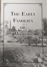
Booklet, The Early Families of Whroo
Tells a short story of the early families who settled at Whroo, a gold mining area, located near Rushworth. The town is no long in existence. Written by Doris KIngA5 size booklet with soft cardboard cover. Cover has a black frame in from the edge with the book title in that in black print. Cover is a grey scale photograph of the Whroo mining site. 88 pages.titlewhroo, families of whroo, doris king -
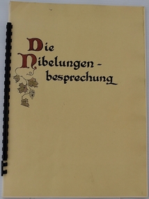 Tatura Irrigation & Wartime Camps Museum
Book, Adolf Wilke, Die Nibelungen Besprechung, 1940's
This manuscript was the brain child of German, Adolf Wilke, Afrika Korp, Prisoner of War. In a cell in Camp 13 he watched smoke from a chimney of the Recreation Hall where his mates were discussing a play. The verses describe various members of the group and their activities. The cartoonist was Count Hans Wolter van Gruenewaldt, a German mining engineer who escaped internment in South Africa, ending as a prisoner in Camp 13. This is a copy of the original. Only 3 copies of the original were made by Gerry von Gruenewaldt - one for Adolf Wilke, one for Gus Pohlig and one for himself. Gerry had a photographed copy made, printed and bound and donated it to the Tatura Museum.Cream coloured card front and back, bound together with a black multi ring binder. Photographed pages of the original printed and put together in book form. Name of book on front top left in black print with first letter of each word in red. Inside pages are on cream card. Text is in German.camp 13, world war ii, tatura, murchison, prisoner of war camps, german pows -
Tatura Irrigation & Wartime Camps Museum
Book, Deep Down
Tatura Presbyterian Sunday School 3rd prize awarded to Edgar Mitchell, December 1917. Teacher Mrs Officer.Green hard cover book, decorative scrolling in blue around edge of front cover and spine. Title in gold letters. Sketch of mining scene. 416 pagespresbyterian sunday school prize, tatura presbyterian church, edgar mitchell, mrs officer -
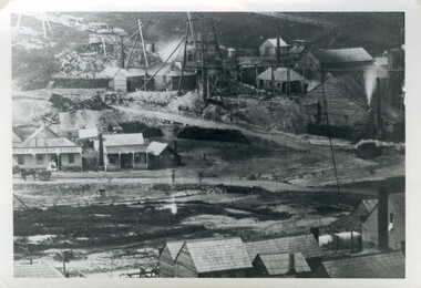 Clunes Museum
Photograph, JEAN GORDON GOVERNMENT PRINTER. MELBOURNE
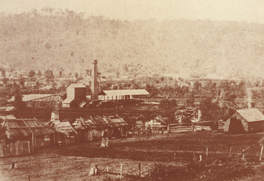
BLACK AND WHITE PHOTOGRAPH OF PORT PHILLIP MINE - LOOKING NORTH FROM WEST SIDE OF CAMP HILL.TULLAROOP CREEK WITH CAMP STREET FORD, PORT PHILLIP HOTEL AND MINING BUILDINGS AND MINING CONSTRUCTIONSphotographs, mining, port phillip mine -
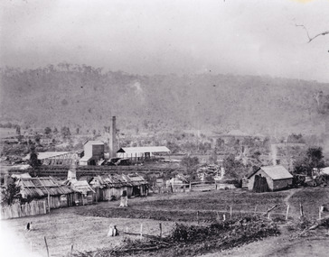
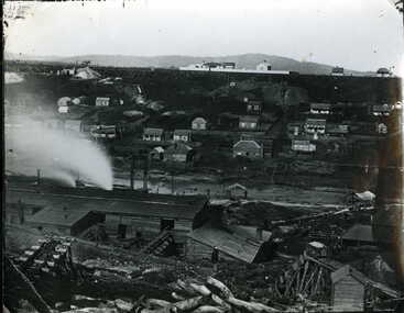 Clunes Museum
Photograph, CIRCA 1859
NEGATIVE OF THIS PHOTO IS AT LATROBE LIBRARY, LATROBE STREET, MELBOURNE. THE PHOTO WAS GIVEN TO THE MUSEUM BY MR.F.C.WEICKHARDT, 1970.A PHOTOGRAPH OF THE PORT PHILLIP MINE BATTERY TAKEN FROM NO.3 CAMP PARADE, CLUNES, OPPOSITE SIDE OF CREEK.local history, photography, photographs, mining