Showing 755 items matching "mining history - victoria"
-
 Bendigo Historical Society Inc.
Book - AUSTRALIAN MINING HISTORY MONOGRAPHS NUMBER 9, 2002
... ...Mining History - Victoria...History House 11 Mackenzie Street Bendigo goldfields VICTORIA History mining Mining History - Victoria Dr.G.H.Bruhn. ...Australian Mining History Monographs Number 9 information about the Australian Colonies by Dr.G.H.Bruhn. Hamburg 1855. Transcribed from old Gothic by Marta.Birrell. Written in German.Dr.G.H.Bruhn.victoria, history, mining, mining history - victoria -
 Bendigo Historical Society Inc.
Book - AUSTRALIAN MINING HISTORY MONOGRAPHS NUMBER 10, 2002
... ...Mining History - Victoria...History House 11 Mackenzie Street Bendigo goldfields VICTORIA History mining Mining History - Victoria Dr.G.H.Bruhn. ...Australian Mining History Monographs Number 10 information about the Australian Colonies by Dr.G.H.Bruhn. Hamburg 1855. Transcribed from old Gothic by Marta.Birrell. Written in English.Dr.G.H.Bruhn.victoria, history, mining, mining history - victoria -
 Bendigo Historical Society Inc.
Book - AUSTRALIAN MINING HISTORY MONOGRAPHS NUMBER 2, THE POWDER MAGAZINES OF VICTORIA, c2000
... AUSTRALIAN MINING HISTORY MONOGRAPHS NUMBER 2, THE POWDER MAGAZINES OF VICTORIA...Mining history... powder magazines... Victoria...Australian Mining History Monographs Number 2, The Powder Magazines of Victoria. Publisher: Zlota Press, Strathfieldsaye Victoria. 24 pages....History House 11 Mackenzie Street Bendigo goldfields GOLD Goldfields powder magazines Mining history powder magazines Victoria Ralph W Birrell Australian Mining History Monographs Number 2, The Powder Magazines of Victoria. ...Australian Mining History Monographs Number 2, The Powder Magazines of Victoria. Publisher: Zlota Press, Strathfieldsaye Victoria. 24 pages.Ralph W Birrellgold, goldfields, powder magazines, mining history, powder magazines, victoria -
 Bendigo Historical Society Inc.
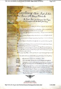
Book - BENDIGO GOLDFIELDS PETITION 1853
... mining licences...History-Australia-Victoria-Bendigo-Gold Miners....History House 11 Mackenzie Street Bendigo goldfields GOLD Goldfields mining licences History-Australia-Victoria-Bendigo-Gold Miners. ...The 1853 Bendigo Goldfields Petition, containing names of Gold Diggers and other residents, to his Excellency Charles Joseph La Trobe Esq Lieutenant Governor of the Colony of Victoria with their grievances regarding license fees & other matters.gold, goldfields, mining licences, history-australia-victoria-bendigo-gold miners. -
 Koorie Heritage Trust
Book, Banfield, Lorna L, Like the ark : the story of Ararat, 1955
... Ararat (W Vic SJ54-08) | Western District (W Vic SJ54-07) | King Billy Billy | Pioneers -- Victoria -- Ararat -- History | Gold mines and mining -- Victoria -- History | Colonisation | Food | Settlement and contacts - Settlers | Race relations - Violent - Massacres...Koorie Heritage Trust Levels 1 & 3, Yarra Building Federation Square, Melbourne melbourne Ararat (W Vic SJ54-08) | Western District (W Vic SJ54-07) | King Billy Billy | Pioneers -- Victoria -- Ararat -- History | Gold mines and mining -- Victoria -- History | Colonisation | Food | Settlement and contacts - Settlers | Race relations - Violent - Massacres murders poisonings etc. - To 1900 | Economic sectors - Agriculture and horticulture - Pastoral industry - Sheep and wool | Djadja wurrung / Dyadyawurrung / Dja Dja Wrung people (S31.1) (Vic SJ54-04) A history of the settlement of Ararat by one of the descendants. ...A history of the settlement of Ararat by one of the descendants. Most references to Aboriginal people in Chapter IV (scattered references elsewhere). Early relations between Kalkadoondeet (Kalkatungu) and Jajowurrung (Djadjawurrung) people and settlers. Violence and retribution reulting from tensions over the grazing and destruction of settlers, sheep and cattle which had overrun their waterholes and hunting groungs. Numbers and names of some Aboriginal people killed in the Ararat region. Establishment of rival 'sheep stations' by the Djadjawurrung people led by King Billy Billy.202 p. :ill ; 22 cmA history of the settlement of Ararat by one of the descendants. Most references to Aboriginal people in Chapter IV (scattered references elsewhere). Early relations between Kalkadoondeet (Kalkatungu) and Jajowurrung (Djadjawurrung) people and settlers. Violence and retribution reulting from tensions over the grazing and destruction of settlers, sheep and cattle which had overrun their waterholes and hunting groungs. Numbers and names of some Aboriginal people killed in the Ararat region. Establishment of rival 'sheep stations' by the Djadjawurrung people led by King Billy Billy.ararat (w vic sj54-08) | western district (w vic sj54-07) | king billy billy | pioneers -- victoria -- ararat -- history | gold mines and mining -- victoria -- history | colonisation | food | settlement and contacts - settlers | race relations - violent - massacres, murders, poisonings etc. - to 1900 | economic sectors - agriculture and horticulture - pastoral industry - sheep and wool | djadja wurrung / dyadyawurrung / dja dja wrung people (s31.1) (vic sj54-04) -
Federation University Historical Collection
Document, Zelda Martin, Central Victorian Goldmining towns - Boom Towns or Ghost Towns?, c1996
... Bibliography *Australia's Mining History * Bibliography - Land Surveys Victoria - *1853 Administration (Statistics and Other) includes: schools / ministers of religion / police / military / local administration / licences for sale of spirits / distances between various Victorian gold fields. * Victoria Government Gazette (Copy) - N0. 116, 12/12/1854 includes: Gold Felds Commission of Enquiry & No. 85, 15/09/1854 - Addresses presented to the Lieutenant Governor (Sir Charles Hotham) during his tour through the Gold Fields of Victoria,1854. ...Bibliography *Australia's Mining History * Bibliography - Land Surveys Victoria - *1853 Administration (Statistics and Other) includes: schools / ministers of religion / police / military / local administration / licences for sale of spirits / distances between various Victorian gold fields. * Victoria Government Gazette (Copy) - N0. 116, 12/12/1854 includes: Gold Felds Commission of Enquiry & No. 85, 15/09/1854 - Addresses presented to the Lieutenant Governor (Sir Charles Hotham) during his tour through the Gold Fields of Victoria,1854. ...Zelda Martin was a PhD candidate at the University of Melbourne.[.1] 4th item in light blue display book titled Research Approach/Overview of Chapters/Confirmation of Canditure/Chapters1,2,3&4 of proposed thesis. *Twenty-seven page article on Victorian goldfields towns titled: Central Victorian Goldmining Towns - Boom Towns or Ghost Towns. The article was written during the author's PhD study. It outlines the context methodology, and resources and the chapters of the proposed thesis: (1) Central Victorian Goldmining Towns - The Context (2) Contemporary Views of the Factors Necessary for Town Growth (3) Outward Manifestations of Town Growth (4) The Trappings of Government (5-9) The Main Towns and Their Hinterland. [.2] 5th item in Light Blue display book as above item. *Chapter 1 of proposed thesis titled 'Pick, Shovel and Tin Dish Mining.' Covers in Section A: Central Victoria - Pre 1851: Aborigines in Central Victoria, Squatters, and Government. Section B: The years 1851-1854: The Early Gold Rushes, Government Reaction, Township Surveys, Legislation, Town Development, Local Government and Early Settlement. [.3] 6th item in Light Blue display book as above item. *2A of proposed thesis titled 'Contemporary Views of the Factors Necessary for Town Growth'. Similar information to Chapter 1 plus extra re towns and maps. Sections: Introduction, Context of Place - Geographical Towns Listed, The Context of Time - Pre1851 Aborigines, Governance of Port Phillip, The Squatters, The Villages of Central Victorian Highlands, Conclusion, Condensed Version of Chapter2B. [.4] 7th item in Light Blue display book as above item. *Chapter2B of proposed thesis. Sections: Area of Research, Schools, Banks, Newspapers, Progress Association, Town Development - Sandhurst (Bendigo), Ballarat, Castlemaine,, Maryborough, Ararat and Stawell. [.5] 8th item in Light Blue display book as above item. *Chapter 3 of proposed thesis titled 'Outward Manifestations of Town Growth'. Sections: Introduction, Contemporary Writing, Educationalists, The Bankers, The Townsfolk, Current Theory, General Theories of Urban Development, and Conclusion. [.6] 9th item in Light Blue display book as above item. *Chapter 4 of proposed thesis titled 'Trappings of Government' Sections: Introduction, Early Government Attitudes to Mining and Town Development, Law and Order, Township Surveys, Legislation, Local Government, Transport and Communication, The People and Lobbyists. [.7] 10th item in Light Blue display book as above item. *'The Rise and Fall of Central Victorian Goldmining Towns'. Includes a map showing main Goldfields, a table showing towns and villages at two points in time - 1857 and 1871; a Bibliography of Primary and Secondary Sources. [.8] Resource No1. Black display book titled Local Towns 1 : Alma: *Brief history *Directory *Maps Amphitheatre / Mountain Hut: *Brief History Post Office Directory Ararat: *Brief History *Post Office Directory 1869 - Alphabetical Listing by Occupation *Ararat - Prominent Citizens of 1858 *Langi-Morgala Museum Avoca: *Brief History *Excerpts from 'Avoca The Early Years', Margery and Betty Beavis; pg1 - Beginnings; pg11 - The Midas Touch; pg25 - Local Gold Escorts; pg27 - A Town is Born; pg51- The Administration of Justice; pg53 - The Ways of the Law; pg61 - News of the Day; pg65 - A Time to Play; pg72 - Land Ownership *Post Office Directory (Bailliere's) 1869 *Tourism Map and Information of area *Historic Avoca - A 5.5km Tour *Avoca & the Pyrenees Region - information pamphlet Ballarat: *Early History of Ballarat - Ballarat Historical Society, Publication No.1: origin of the name; Ballaarat - the Beginning; Fabulous Yields from the Ballaarat Goldfield; *Streetscape Lydiard Street. *Hand drawn map showing Leigh River, Old Portland Bay Road, plaque on road to Colac; etc. *Newspaper article re 'The Theatre Royal' ( which stood in the vicinity of the current Owen Williams store) - 'The News'15/04/1998 *Article - 'Ballarat's Mechanics' Institute Lives On' Ballarat Courier, 14/09/1985 *Article - Standing the Test of Time' The News 17/11/1993 re The Mechanics Institute & picture of the Reading Room *'Ballarat a Study of a City, Phyllis Reichl, pub. Nelson, 1968; no.3 place, time and people field studies series *Investigator Vol.33 No.2, 1998 Geelong Historical Society. Article on pg75 describes Ballarat in 1861 *Folded poster - 'Ballarat 100' a history of telegraph communication, pub. Telecom. Beaufort (Fiery Creek): *Brief history *Post Office Directory [.9] Resource No.2 Black Folder Titled Towns cont.No2 Bendigo (Sandhurst): *'Family & Local History at the Bendigo Library - 1851-2001 150 years of gold'. *Bendigo Government Camp in 1853 illustration; key to sketch and names of Government officers stationed there *Excerpts from 'Bendigo and Vicinity' Adolph Haman *The Bendigo Goldfield Registry - pgs 1-7 Introduction *Excerpt: 'Breaking the Grip' *Excerpt: The Most Go-Ahead Place *Excerpts from 'History of Bendigo' - anti license agitation; laying out of town; proposed railway; gold calls and dividends; the Sandhurst Municipality; journalism *Bibliography Blackwood: *Excerpts from 'Aspects of Early Blackwood - The Goldfield, the Landmarks, the Pioneers' Alan J Buckingham and Margaret F Hitchcock, JG Publishing,1980 Buninyong: *A Brief History *Investigator Vol1 No.2 Feb 1966 Geelong Historical Society. Pg3 - Article re gold escort route - Mt Alexander to Adelaide - (see a simple monument on the Western Highway a few miles out of Horsham. Pg 15 - Ballarat Excursion - re the finding of gold. *Three articles published by Buninyong and District Historical Society Inc: (Magpie Exploration; Finding Gold In The Green Hills; Magpie Exploration; Burnt Bridge to Cargarie to Mt Mercer) *Copies of newspaper articles/items *Buninyong Street Directory Carisbrook: *In the Beginning There Was Carisbrook *The History of the Carisbrook Racecourse Carngham / Snake Valley: *Brief History *Directory Castlemaine: *Directory 1865-1866 - Alphabetical and Street *Poster - Castlemaine A Contemporary Guide "The Great Centre" 1866 - A Contemporary Guide to the Fascinating Past *Pamphlet - Castlemaine District Community Hospital *Map - Castlemaine, Maldon & Surrounding Districts *Map and Information - The Dry Diggings Track - a 55kl walk among historic goldfields relics ( Castlemaine Fryerstown Vaughan Mt Franklin Hepburn Daylesford) *Postcard - Former Court House *Directory 1867 - Alphabetical, Trade [.10] Resource No.3 Grey folder Titled Towns 3 Creswick to Maryborough Creswick: *Brief History *Booklet - "Creswick Cemetery Walk" *Booklet - The Buried Rivers of Gold Heritage Trail Creswick *Creswick Historical Museum Information Sheet *Chronological History of Creswick *Alphabetical Directory of the Borough of Creswick *Creswick's Creek Directory 1856 *Historic Creswick Walking Tour *A Brief Account of the Schools of Creswick - Past and Present *100 Years of Railway Travel in Creswick *The Berry Deep Leads *The Spence Home at Jackass Gully in the Creswick State Forest ( William Guthrie Spence - Pioneer) *The New Australian Mine and the 1882 Disaster *Creswick District News, Issue 7, July August 1999 *The Creswick Miners Walk - Information and Map *Maps Chewton: *Brief History *Directory Clunes: *Brief History *Clunes Street Directory Daylesford: *Brief History *Notable Bushfires in Daylesford District Over More Than a Century - "Black Thursday" 1851; 1862; 1899; the Disastrous Hepburn Fire of 1906; 1939; 1944; 1969. *Post Office Directory -Daylesford and Hepburn Dunolly / Inkerman: *Brief History *Directory *Pamphlet - Goldfields Historical Museum *Pamphlet - Historic Dunolly - Victoria's Best Kept Secret *Map of Gold Workings at Dunolly Area - showing where the main gold rushes occurred *Brief History - Inglewood *Directory - Inglewood - Name Occupation, Dwelling Kingower: *Brief History *Directory - Name / Ocupation / Dwelling Linton / Happy Valley / Piggoreet: *Brief History *Directory - Lintons McIvor: *"A History of the Shire and the Township of Heathcote" by J.O. Randell Majorca: *Brief History *Official Post Office Directory 1869 - Name / Occupation/ Address Maldon (Tarrangower): *Brief History Part 1 *Brief History Part 2 *Post Office Directory *List - Alphabetical Order by Names plus Business and Trade (Tarrangower Times Oct/1858) *List - Alphabetical Order by Trade plus Name and Business *Directory - Name / Occupation / Dwelling Maryborough: *Worsley Cottage - built by Arthur Worsley, a contractor in stonework in 1894 [.11] Resource No. 4 Blue Display Book titled Towns 4 Moliagul to Stawell Moliagul: *Brief History *Moligul Legislative Assembly (Voting?) List - Names and Occupations *Moliagul Victorian Post Office Directory 1868 - Name / Ocupation / Address / Comments *"The Welcome Stranger" gold nugget *The Sunday School *The Welcome Stranger Discovery Walk - information and map Moonambel (Mountain Creek) Redbank *Brief History *List of names extracted from advertisments of the Pioneer and Mountain Creek Advertiser 16/02/1861. *Bailliere's Directory 1869 - Alphabetical List of Name / Occupation / Place St Arnaud: *Brief History Sebastapol: *Brief History *Directory 1869 - Alphabetical by Name; plus occupation and address. Browns and Scarsdale: *Brief History *Browns Street Directory - Name and Occupation Smythesdale: *Brief Description *Smythesdale Street Directory -Name and Occupation Stawell (Pleasant Creek) *Brief History *Victorian Official Post Office Directory - Name /Occupation / Dwelling *Chronology - 1841-1920 *Production of gold statistics - 1879 - 1900 *Big Hill *Extracts from "The Golden Years of Stawell". Chapt 1 - Stawell's Coming Out. Capt. 2 - The Gold Rush. Caapt.3 - Cradle of Democracy. Chapt.4 - The Reefs Becomes Stawell. Chapt. 5 - Rushing In. Chapt.6 - The Pioneers. Chapt 7 - The Decade of Optimism. [.12] Resource No. 5: Blue Display Book titled 'Towns Steiglitz to the The Golden Triangle. Steiglitz: Brief History Victorian Post Office Directory 1869 *Map of Steiglitz *List of maps relevant to Steiglitz history *Information 6 tables of data from "Reports of Mining Surveyors Talbot (Back Creek) Brief History Taradale: Post office Directory 1869 - Name/Occupation/Street. Also list in alphabetical order by Occupation Taradale *Chronological Reference to Taradale Mines *Water - The Coliban System of Waterworks *Joseph Brady *The Syphon Tarnagulla (Sandy Creek) *Brief History *Tarnagulla Businessmen Cameos to give depth to advertisments in 'The Tarnagulla Courier' various issues 1864-1871 *Directory - Name/Occupation /Address *List - Name/Business/Trade Wedderburn (Koorong) *Brief History *List - Name/Occupation The Golden Triangle: *The Early Rushes - Wedderburn / Moliagul / Sandy Creek - Tarnagulla / Jones Creek - Waanyarra / Kingower / Dunolly - Goldsborough / Inglweood *Census of 1857 - Population / Occupations *1858-1871 - A Time of Consolidation- Wedderburn / Moliagul / Sandy Creek- Tarnagulla / Arnold *Census 1871 - Population *Information gleaned from the census data - Demographics / Population / Occupations / marital / Birthplace / Religion / Literacy/ Occupation and Housing Cameos *Graphs - Birthplace of settlers /Male-Female Ratio / Married males / Children under 15 as Percentage of Population / Religion *Census 1857 - Statistical data *Maps *Bibliography [.13] Resource No. 6 - Black Display Book Information and Research in Central Victoria including: *Banking - Research from ANZ Bank Archives *Institutions - also includes articles listed from the Ballarat Times Newspaper *Australian mining History Association - A.M.H.A. Bibliography *Australia's Mining History * Bibliography - Land Surveys Victoria - *1853 Administration (Statistics and Other) includes: schools / ministers of religion / police / military / local administration / licences for sale of spirits / distances between various Victorian gold fields. * Victoria Government Gazette (Copy) - N0. 116, 12/12/1854 includes: Gold Felds Commission of Enquiry & No. 85, 15/09/1854 - Addresses presented to the Lieutenant Governor (Sir Charles Hotham) during his tour through the Gold Fields of Victoria,1854. Addresses on behalf of : the people of Bendigo; Members of the Church of England, Bendigo; Members of the Wesleyan Church on the Bendigo Gold Fields; Bendigo Gold District General Hospital; the Bendigo Prospecting Association; Committee of the Bendigo Local Exhibition; Bendigo District Medical Association; Coloured Americans Resident at Bendigo; German Inhabitants of Bendigo; Landowners, Inhabitants, and Miners of Castlemaine; Inhabitants of Forest Creek; Inhabitants of Heathcote and Gold Miners of McIvor; Residents and landholders of the District of Bacchus Marsh; Inhabitants of Kilmore and Vicinity. *Gold Fields Correspondence 1853: letter from Lieutenant Colonel Valiant, (Officer commanding the Troops in Victoria) to the Lieutenant Governor re threatened disturbance at Sandhurst (Bendigo) regarding the Gold License Fee. * Extracts from a book "Victoria" re Gold Fields Commission of Enquiry involving mainly Ballarat and Castlemaine and a chapter titled 'A Tour to the Victorian Gold-Fields' *Lists of central Victorian newspapers - listed by date published 1851to 1874; by first date available to State Library. *A list of cities and towns showing County, population in 1861 &1871, and municipal status. [.14] Resource no.7. Black display book. *Reference: Papers presented to Parliament Victoria - 1859-1860 4 volumes - relevant sections copied. Contains information on Branches of Government. General / Finance / Gold / Gazette / Commission and Warrant / Statistic. *Gold Fields Act. In accordance with the Act the gold fields are divided into six districts - Ballaarat, Castlemaine , Sandhurst, Avoca, Ararat, and Beechworth.. Official staff in each gold district consists of a Resident Warden, Wardens, Wardens' Clerks, Bailiffs, Chinese Protectors, Chinese Interpreters, and Mining Surveyors. *Gold Receiver *Gaols *Police magistrates and Clerks of Petty Sessions, etc. *Field Branch *Immigration and Emigration Overland - Chinese - 1859 *Population on the Goldfields *The Geological Survey - The Government Geologist is assisited by staff from four branches - the office Branch; the Publishing Branch; the Field Branch and the Museum Branch. *Commission to Enquire Into Sludge dated 10/02/1859 (Some sections copied) - Report to the Honorable Chief Commissioner of Public Works, Melbourne re the mode of carrying the sludge from the puddling mills in Sandhurst without interfering with the drainage of the town and the roads in the neighbourhood. [.15] Resource No.8: Camel display book titled Resource No. 8. Aborigines *Lists of book titles - +"Readings in Victorian prehistory" +"The Aborigines of Port Phillip" +Aboriginal languages and clans" +"A History of the Port Phillip District" +"Langi Ghiran 1: Aboriginal Rock...." +"Koorie History: sources for aboriginal studies in the State Library of Victoria", ed. Tom Griffiths, Melb. Friends of the State Library, 1989 +"The Public Lands of Australia Felix"; settlement and land appraisal in Victoria1834-91 with special reference to the Western Plains", J.M.Powell, Melb. Oxford University Press 1970 +*Bibliography of the Victorian Aborigines' from the earliest manuscripts to 31st December 1970, Massoa, Aldo, Melb. Hawthorn Press, 1971 +"Aborigines in Colonial Victoria, 1836-1886", M.F. Christie, Sydney University Press, 1979 +"Urban and Industrial Australia: readings in Human Geography" ed J.M. Powell, Melb. Sorrett Pub. 1974 *Extracts: -Processes of Pioneer Settlement - The Squatting Occupation of Victoria, 1834-60. J.M. Powell -Areal Variations in the Class Structure of the Central-Place Hierarchy. P. Scott - Volume1 and Volume 2: Notes Relating to the Habits of the Natives of Other Parts of Australia and Tasmania. Compiled from various sources for the Government of Victoria by R Brough Smyth. John Curry, O'Neil, Melb. 1st pub. Melb. 1876. p31-45 - Numbers and Distribution of the Aborigines in Victoria -Victorian Aborigines 1835-1901 - A Resource Guide to the Holdings of the Public Record Office, Victoria; published by the Government Information Centre 1984. *History of the Aboriginal Artefacts Displayed in the Daylesford Museum. F. G. Powell (4 page pamphlet) *Letter to Zelda Martin from Peter Lovett, Cultural Officer, Ballarat & District Aboriginal Co- Operative, 05/02/1997 *Map: Ian Clarke Victorian Tribunal Boundary Map - Clans of Central Victoria. *Victorian Rock Art and Mythology - Article about Mount Langhi Ghiran and myths of the Tjapwarong people. *Two Aboriginal myths relating to the Grampians - 'The Monster Emu' / 'The Aquisition of Fire', by the Aborigines in the Grampians Areas *Article titled (chapter 8) Ballarat - information re camping sites in the region. Lake Wendouree / Lake Burrumbeet (includes a myth) / Mt Bunninyong / Lal Lal / Pitfield / Mount Elephant / Mount Egerton / Meredith / Lake Goldsmith / Lake Learmonth / Ercildoune *Notes on the Aborigines of the Wider Ballarat Region plus European names=Aboriginal names. John Morris 26/07/1995 *Role of Aborigines in Town Development in Central Victoria. Mentions Native Police Force est. in Port Phillip 1842 and Central Board for Aborigines est. 1860 *The Grave of King Billy. (Frank Wilson) Pamphlet. *Camping Places in Central and Northern Victoria. Article re Lake Burrumbeet site. *Programme for the Unveiling of Memorial Cairn for Edward Stone Parker 1802-1865. Note portrait not accurate. Accurate portrait is available in the book "A Successful Failure A Trilogy The Aborigines and Early Settlers", Edgar Morrison, Graffiti Publications, 2002. * Large envelope addressed to Mr G Netherway containing newspaper cuttings regarding the life of Edward Stone Parker, the unveiling of the Memorial Cairn as mentioned above, articles titled 'Episodes from Our Early Days' (Edgar Morrison, Yandoit)- The Black's School, A School At Last and The Final years. Also a typed page titled 'Historical Background to E.S.Parker's Career. Includes an interesting tale titled 'When the cat lay doggo' re laying power leads for the unveiling ceremony at the memorial site. [.16] green display folder titled 'Research Aids' *List of references to Commissioners' & W'ardens' Reports (formerly held at La Trobe Library Archives, now at Public Records Office [PRO]). Indicates town referred to / date of report / name of camp if different to town. * Archive information re Anglican Records *Movement around the Goldfields - Miners and Storekeepers - usefulness of newspapers in providing information - areas covered - Castlemaine, Maldon, Ararat, Stawell, Tarnagulla, Dunolly. *Port Phillip /Victoria Directories 1839/1867 - Chronological list of Directories included in this series. *"Notes on the History of Local Government in Victoria" A.W. Greig Melb. University Press 1925 - Photo-copied extract p5-p40. (Source - Deakin University Library) - Introduction by W.Harrison Moore. Section 1 - Development in New South Wales Before Separation. Section 2 - Development in Victoria After Its Separation from New South Wales. Hand written notations: 'roads, markets, and local government 1855 on' ;'opportunity of squatters in parliament' and 'opportunities of matters in parliament p33' * Notes on the Establishment of Surveyor General's Department 1851and Commissioner of Crown Lands and Survey. * Newspaper articles from The Argus, 1849, re the discovery of gold in the Pyrenees region. * Excerpt - a report on schools - A.B.Orlebar, Inspector; re the need for permanent school buildings rather than tents. *Excerpt from - 'Approaches to Urban History', Sean Glynn: The Case for Caution * Except from - 'The Urban Sprinkle', Weston Bate: Country Towns and Australian Regional History *Reference- 'The History of Land Tenure in the Colony of Victoria', John Quick. References the Haines Land Bill, land tenure and Land Leagues. [.17] Light blue envelope folder titled 'Birtchnell's Ballarat, etc. Directory 1862 *Contains various directories for Smythesdale, Buninyong, Clunes, Brown's and Creswick. [.18] Red envelope folder no.2 titled Victorian Gazetteer *Selected pages from 1869 Victorian Gazetteer on A4 paper (with a handwritten note questioning if some pages are from 1868 Victorian Gazetteer as appears to be different sizes - A3 pages.) Information includes locations and descriptions of towns, hotels, banks, communications and populations. (Does not include names, residences and occupations) [.19] Red Envelope folder titled Bailliere's Official Post Office Directory 1868 (or1869 or a mixture of both?) *Preface *Contains a selection of pages of towns highlighted in yellow in the the index *Work on this directory was commenced in 1867. *Information includes: Municipalities - mayors and councilors; lists of towns naming male inhabitants and their occupations. [.20]Yellow manila folder titled Post Grad Seminar Presentation 1996 *Gives some background to Zelda Martin's proposed thesis and why she chose the topic Gold Mining Towns Boom or Bust [.21] A3 display book - No. 1A * A list of 'Relevant Newspapers collected: The Tarrangower Times and Maldon Advertiser (first published 1858) Includes dates 1858-1867. The Mount Alexander Mail. Includes dates 1854-1866 The Tarnagulla Courier. Includes dates from1864-1871 Dunolly and Burnt Creek Express. Includes dates from 1862-1871 * Selection of newspaper pages from The Mount Alexander Mail 1854 to 1856, mostly showing advertisements for businesses and services provided to that community. [.22] A3 display book - No. 1B * Selection of newspaper pages from The Mount Alexander Mail 1857 to 1866, mostly showing advertisements for businesses and services provided to that community. [.23] A3 display book -No. 2 * Selection of newspaper pages from The Tarnagulla Courier 1864 to 1871, mostly showing advertisements for businesses and services provided to that community. [.24] A3 display book - No. 3 *Selection of newspaper pages from The Tarrangower Times (and Maldon and Newstead) Advertiser 1858 to1867, mostly showing advertisements for businesses and services provided to that community. [.25] A3 display book - No.4 * Selection of newspaper pages from The Dunolly and Burnt Creek Express; and The Dunolly and Betbetshire Express 1862 to 1871, mostly showing advertisements for businesses and services provided for that community. [.26] A3 display book - No.5 Includes: * Bryce Ross's Diggings Directory. Includes instructions for using this directory. This directory was used by "all persons having connexion or desiring to communicate with 'working parties, private friends, or Stores at the Diggings." As a directory for each area wwas completed it was published in each month's issue of Bonwick's "Digger's Magazine." Years c1852/1853. This Directory commences first at the head of Forest Creek. Includes a directory for Bendigo and Ballarat. Of interest at the end of the Bendigo and Ballarat directory is a list of the number of storekeepers, butchers, doctors, smiths, eating houses, lemonade sellers and chapels. * The Castlemaine Directory and Book of General Information Comprehending Glass's Model Calendar for the Two Years 1862 and1863. "zelda martin, victorian goldfield towns, bendigo, castlemaine, ballarat, maldon, stawell, ararat, maryborough, creswick, avoca, heathcote, banks, bank of australasia, union bank of australia, government camp, sandhurst, water supply, tarnagulla, talbot, back creek, mountain creek, police court, carisbrook, dunolly, thompson's foundry, charles clacy, anthony trollope, robert cecil, mount alexander, urbanisation, national schools, education, govenrment, industry, railway, transport, settlement, land settlement in central victoria, steiglitz, joseph brady, the new australian mine, berry deep leads, william guthrie spence, creswick state forest, arthur worsley, worsley cottage, the welcome stranger, moliagul, moonambel, redbank, st arnaud, sebastapol, brown's, scarsdale, clunes, chewton, daylesford, bushfires, inkerman, inglewood, kingower, lintons, happy valley, piggoreet, mcivor, majorca, tarrangower, taradale, the coliban system, the syphon, sandy creek, wedderburn, koorong, arnold, jones creek, waanyarra, the golden triangle, census 1857, blackwood, buninyong, durham lead, magpie, carngham, snake valley, alma, amherst, daisy hill, amphitheatre, mountain hut, beaufort, fiery creek, counties, population, gold fields commission of enquiry1854, william westgarth, gold license fee, lieutenant colonel valiant, administration of the victorian gold fields, commission to enquire into sludge 1859, e.s. parker, edward stone parker, edgar morrison, mount franklin protectorate, dja dja wurrung, memorial cairn, franklinford, mt franklin memorial cairn, jajowurrong, dja dja wurung, tjaowarong, wothowurong, assistant protectors, daylesford museum, buluk, rock art - grampians, aboriginal mythology - grampians, aborigines, first nations people, mount franklin, aboriginal artifacts, lake burrumbeet, native police force, central board of aborigines, yandoit, commissioners' reports, wardens' reports, port phillip/victoria directories 1839-1867, local government - victoria 1853/1854, surveyor general's department - 1850's, victorian schools 1850's, a.b.orlebar, haines land bill, william charles haines, wilson gray, land tenure, land leagues, victorian gazetteer, the tarrangower times and maldon advertiser - 1858-1867, the mount alexander mail 1854-1866, the tarnagulla courier 1864, dunolly and burnt creek express 1862-1871, bryce rose's diggings directory, the castlemaine directory 1862-1863 -
 Warrnambool and District Historical Society Inc.
Letter, Power of Attorney Augustus Bostock, 1888
... mining companies at that period of Australian history. This is one of a number of documents which relate to the Bostock family who were one of the most important pioneering families of the Western District. They owned and leased various properties around Warrnambool and were involved in many aspects of social and business life. This letter records one of Augustus Bostock’s many interests, being for the Croydon goldmine which is situated on the Gulf of Carpentaria. warrnambool, augustus bostock, croydon goldmines, sandhurst mines, 1888, goldmining, patrick o’neil, Signed Augustus Bostock. White lined paper handwritten in black ink. Coomete, Hexham, Victoria ...Augustus Bostock was the 9th child of Robert & Rachael Bostock of Vaucluse Epping Forest, Van Diemen’s Land. He was only 4 years old when his mother died. He was inspired by his father to seek his fortune in the Western District of Victoria. He arrived around 1850. He married Margaret Aitkin in July 1865. Augustus owned several properties in the district and leased others. He sat on the court of Warrnambool, Mortlake or Hexham as required. He resided at Marramook in Hawkesdale and later moved to Vaucluse in Hopetoun Road Warrnambool, where he died in 1920 at the age of 87. He was involved in many aspects of life in the Western District, racing, cricket, and social activities to name a few. This document relates specifically to power of Attorney in relation to the Croydon goldfields in Northern Queensland which operated in the latter part of the 19th century. By 1907 it was failing although there were attempts to revive it in the 1920’s. Patrick O’Neil authorized as the agent for Augustus Bostock was a confidential mining agent for Sandhurst mines one of the larger mining companies at that period of Australian history.This is one of a number of documents which relate to the Bostock family who were one of the most important pioneering families of the Western District. They owned and leased various properties around Warrnambool and were involved in many aspects of social and business life. This letter records one of Augustus Bostock’s many interests, being for the Croydon goldmine which is situated on the Gulf of Carpentaria.White lined paper handwritten in black ink. Coomete, Hexham, Victoria printed at top right hand corner.Signed Augustus Bostock.warrnambool, augustus bostock, croydon goldmines, sandhurst mines, 1888, goldmining, patrick o’neil, -
Federation University Historical Collection
Book, Digging for Gold: A guide to researching family and local history in Victoria's Central Goldfields, 1988
... Barker Library (top floor) Mount Helen goldfields Gold mining genealogy family history local history localities historical societies Yellow covered book of 121 pages Digging for Gold: A guide to researching family and local history in Victoria's Central Goldfields Book ...Yellow covered book of 121 pagesnon-fictiongold, mining, genealogy, family history, local history, localities, historical societies -
 Orbost & District Historical Society
book, E-Gee Printers Pty Ltd, Gippsland Heritage Journal, June 1990
... history in Gippsland, Victoria, Australia. It is compiled by Meredith Fletcher, Debbie Squires and Linda Barraclough and includes a diverse range of articles, both academic and non-academic. Since No.24 it has been a partially refereed journal. This copy was used in the library of Orbost Secondary College. This item is a useful reference tool on the history of Gippsland. A 64 pp magazine, titled Gippsland Heritage Journal No 8 (June 1990). The cost is $6.00. The front cover is pale orange with a b/w photograph of mining ...Gippsland Heritage Journal is a journal, produced about every nine - twelve months, for those interested in regional, local and family history in Gippsland, Victoria, Australia. It is compiled by Meredith Fletcher, Debbie Squires and Linda Barraclough and includes a diverse range of articles, both academic and non-academic. Since No.24 it has been a partially refereed journal. This copy was used in the library of Orbost Secondary College. This item is a useful reference tool on the history of Gippsland. A 64 pp magazine, titled Gippsland Heritage Journal No 8 (June 1990). The cost is $6.00. The front cover is pale orange with a b/w photograph of mining on Taraga River, Neerim South. The magazine contains photographs, articles on the history of Gippsland. -
 Federation University Historical Collection
Photograph - Photograph - Colour, Happy Valley School, 1985
... history of Happy Valley State School, one of Victoria’s oldest public schools. Key information Address: Ballarat, 3350 Opened: 1 February 1860 Closed: 31 December 1940 School type: Primary School number: 376 Other names: Lucky Woman's Common School, Lucky Woman's State School Search for more school profiles The history of Happy Valley State School 1863 The school opened as Lucky Woman's in 1863. The school was located in the Linton area, a small mining...history of Happy Valley State School, one of Victoria’s oldest public schools. Key information Address: Ballarat, 3350 Opened: 1 February 1860 Closed: 31 December 1940 School type: Primary School number: 376 Other names: Lucky Woman's Common School, Lucky Woman's State School Search for more school profiles The history of Happy Valley State School 1863 The school opened as Lucky Woman's in 1863. The school was located in the Linton area, a small mining ...This photo was taken in 1985. Alf Watson, a descendent of settlers of the district - the Smiths and the Yungs whose children attended this school, is standing to the right of the building. The history of Happy Valley State School 1863 The school opened as Lucky Woman's in 1863. The school was located in the Linton area, a small mining township. The first head teacher was Thomas Lea. 89 students had enrolled. 1883 The name of the school changed to Happy Valley. The brick school building was built in this period. 1920s Enrolment declined in the 1920s to around 10 students. 1932 Enrolment continued to decline and the school was closed. 1933 The school reopened briefly under head teacher Selina McFarlane. 1936 It closed again at some stage before reopening in 1936 under head teacher Maxwell Brown. The school was closed finally in 1936. 1940 The building was sold. 150 years: Happy Valley State School Learn about the history of Happy Valley State School, one of Victoria’s oldest public schools. Key information Address: Ballarat, 3350 Opened: 1 February 1860 Closed: 31 December 1940 School type: Primary School number: 376 Other names: Lucky Woman's Common School, Lucky Woman's State School Search for more school profiles The history of Happy Valley State School 1863 The school opened as Lucky Woman's in 1863. The school was located in the Linton area, a small mining township. The first head teacher was Thomas Lea. 89 students had enrolled. 1883 The name of the school changed to Happy Valley. The brick school building was built in this period. 1920s Enrolment declined in the 1920s to around 10 students. 1932 Enrolment continued to decline and the school was closed. 1933 The school reopened briefly under head teacher Selina McFarlane. 1936 It closed again at some stage before reopening in 1936 under head teacher Maxwell Brown. The school was closed finally in 1936. 1940 The building was sold. Can you help us find records for this school? The Public Record Office Victoria (PROV) only hold historical correspondence records for this closed school. If you have any, or if you know of any, please let us know by emailing [email protected] Updated 19 May 2022.1 Happy Valley State School photographed in June 1985. Alf Watson observing the building. .2 View from the back and side of the Happy Valley State School.1 Verso: Grandma Watson's school Happy Valley June 1985 (Grandma nearly 97 years) Alf in bacckground. Edith Emma Watson b Yung. Alf - son of Edith and John Richard Watson. .2 Verso: School where Grandma Watson eudcated. Happy Valley. June 1985happy valley state school, lucky womans, lucky woman's common school, lucky woman's state school -
Federation University Historical Collection
Book - Book - Scrapbook, Ballarat College of Advanced Education: Scrapbook of newspaper cutting, Book 13; May 1983 to October 1983
... The cuttings cover the period from 23 May 1983 to 26 October 1983. . employment advertisements application for enrolment outline of courses deputation to see minister re gas levy role for colleges computing at bcae engineering students may transfer institutions fear information act bust of prof smith presented to smb western mining corporation awards john de vries ian carroll wayne herbertson soil conservationists bust of dick richards chinese actress visits ballarat bcae host to hundreds tertiary orientation program russian violinist at founders hall teachers not out of touch employment prospects for teacher graduates bcae open day dr alan reid from csiro short course on micro computers victoria howlett potter charles fahey on oral histories computers becoming part of school system mining raises living standards antarctic oldtimer remembers ethel reynolds - sculptor tribute in bronze dick richards beaufort house 'home for students' jacqueline culvenor - potter deaf and smart `students condemn council sacking brendan mcauley jump rope for heart students give papers on engineering projects australians lucky says uk artist selwyn hoffman shows in exhibition Book with beige cover, front. ...Newspaper cuttings relating to Ballarat College of Advanced Education. These are from various newspapers and include The Age, Ballarat Courier, The Australian, The Herald. The cuttings cover the period from 23 May 1983 to 26 October 1983. . Book with beige cover, front. Spiral bound.employment advertisements, application for enrolment, outline of courses, deputation to see minister re gas levy, role for colleges, computing at bcae, engineering students may transfer, institutions fear information act, bust of prof smith presented to smb, western mining corporation awards, john de vries, ian carroll, wayne herbertson, soil conservationists, bust of dick richards, chinese actress visits ballarat, bcae host to hundreds, tertiary orientation program, russian violinist at founders hall, teachers not out of touch, employment prospects for teacher graduates, bcae open day, dr alan reid from csiro, short course on micro computers, victoria howlett potter, charles fahey on oral histories, computers becoming part of school system, mining raises living standards, antarctic oldtimer remembers, ethel reynolds - sculptor, tribute in bronze, dick richards, beaufort house 'home for students', jacqueline culvenor - potter, deaf and smart, `students condemn council sacking, brendan mcauley, jump rope for heart, students give papers on engineering projects, australians lucky says uk artist, selwyn hoffman shows in exhibition -
 Eltham District Historical Society Inc
Book, Otto Rupp, The Life and Experience of an Immigrant, 1999
... It also contributes to the understanding of the early history of Yarrambat including its association with gold mining. Otto Rupp Edna Young Yarrambat tancks corner victoria autobiography migrant An autobiography by Otto Rupp (1904 -1993). ...An autobiography by Otto Rupp (1904 -1993). Transcribed by the Yarrambat Historical Society from the original manuscript in 1993. Otto Rupp was born in Switzerland in 1904. He migrated to Australia in 1927 and after working in the South Australian outback bought land in Yarramabt. He married Edna Young in 1935. This diary includes recollections of his life from 1927 to 1983. Bachelor Days, 1919-1935: Murray Bridge, Karoonda, Wirrabara, Appilia, South Australia, Central Australia, Tancks Corner (Yarrambat), Balranald, and Yarramabt. Married Life, Gold in Yarrambat, Times, People and Memories, 1943-1987.58 p. : ill., fascsims., geneal. table ; 30 cmnon-fictionAn autobiography by Otto Rupp (1904 -1993). Transcribed by the Yarrambat Historical Society from the original manuscript in 1993. Otto Rupp was born in Switzerland in 1904. He migrated to Australia in 1927 and after working in the South Australian outback bought land in Yarramabt. He married Edna Young in 1935. This diary includes recollections of his life from 1927 to 1983. Bachelor Days, 1919-1935: Murray Bridge, Karoonda, Wirrabara, Appilia, South Australia, Central Australia, Tancks Corner (Yarrambat), Balranald, and Yarramabt. Married Life, Gold in Yarrambat, Times, People and Memories, 1943-1987.otto rupp, edna young, yarrambat, tancks corner victoria, autobiography, migrant -
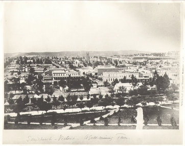 Bendigo Historical Society Inc.
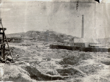
Photograph - SANDHURST - VICTORIA, A GOLD MINING TOWN, Earliest c 1885
... History House 11 Mackenzie Street Bendigo goldfields PLACE Landscape view sandhurst from rosalind park B+W Photograph. Copy of 'Sandhurst - Victoria a Gold-Mining Town'. ...B+W Photograph. Copy of 'Sandhurst - Victoria a Gold-Mining Town'. View from Rosalind Park. Notable BLDOR Shamrock Hotel, St Pauls Church, railway station. Inscription: on RH 'Extract from cement -???'. Photograph shows early Sandhurst with Chimney of Goldmine of R.H.S(R.S.L now occupies this site).place, landscape view, sandhurst from rosalind park -
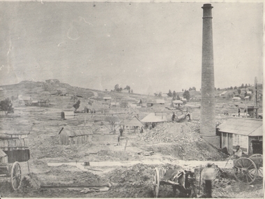 Bendigo Historical Society Inc.
Photograph - GOLD MINES BENDIGO 1861, 1861
... History House 11 Mackenzie Street Bendigo goldfields PLACE Mining site sth victoria hill ? ...Copy of photograph of mine site with dwellings to right top, mine buildings, 'whim?' drays, horse and work men. Large brick chimney on right. B+W photo. On back 'Gold Mines Bendigo 1861','Probably, looking NW up New Chum Hill, which was then known as Sth Victoria Hill'.place, mining site, sth victoria hill ?, see also 131.01 -
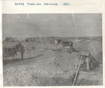 Bendigo Historical Society Inc.
Photograph - HORSE PUDDLING MACHINE VICTORIA HILL?, c.1861
... History House 11 Mackenzie Street Bendigo goldfields PLACE Mining site victoria hill ? ...Black and white panorama with mine workings (puddling machine and two horses and two workers) with scattered (residential?) buildings in open rough background. Inscriptions: on front - 'horse puddling machine 1861' hand printed across top. On back - 'Gold Mines Bendigo 1861, this could be Victoria Hill'.place, mining site, victoria hill ? -
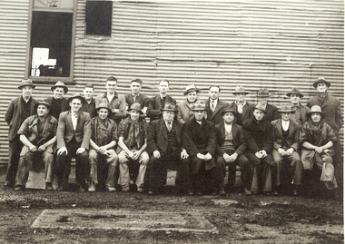 Bendigo Historical Society Inc.
Photograph - NORTH NELL GWYNNE MINE EMPLOYEES, c.1939
... History House 11 Mackenzie Street Bendigo goldfields North Nell Gwynne Gold mining gold Nell Gwynne mine employees Inscriptions: hand written on back - 'North Nell Gwynne'. 'A Richardson, 29 Harrison St, Bendigo'. Royal Historical Society of Victoria ...Black and white photograph of twenty two miners in front of corrugated iron building. One man in centre of front row dressed in three piece suit and tie. Inscriptions: hand written on back - 'North Nell Gwynne'. 'A Richardson, 29 Harrison St, Bendigo'. Royal Historical Society of Victoria, Bendigo Branch. Circular Stamp on rear. Approx. 1939north nell gwynne, gold mining, gold, nell gwynne, mine employees -
 Bendigo Historical Society Inc.
Photograph - NEW CHUM HILL?
... History House 11 Mackenzie Street Bendigo goldfields PLACE Mining site new chum Batchelder Black and white photograph of mine site. Mullock heap in background with various mine buildings. Chimney stack and corrugated iron buildings on right. Mine shaft holes in foreground. Whims centre back. Hand written on back 'Gold Mines Bendigo. Probably New Chum Hill. Looking North. Phoenix, later Old Chum Mine at summit. JB Lazarus' claims in foreground. RT. 'Johnsons No. 2' on back - Royal Historical Society of Victoria ...Black and white photograph of mine site. Mullock heap in background with various mine buildings. Chimney stack and corrugated iron buildings on right. Mine shaft holes in foreground. Whims centre back. Hand written on back 'Gold Mines Bendigo. Probably New Chum Hill. Looking North. Phoenix, later Old Chum Mine at summit. JB Lazarus' claims in foreground. RT. 'Johnsons No. 2' on back - Royal Historical Society of Victoria, Bendigo Branch. Circular stamp. History: Prev. ACC. No. MNG 2Batchelderplace, mining site, new chum -
 Bendigo Historical Society Inc.
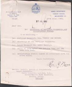
Document - MCCOLL, RANKIN AND STANISTREET COLLECTION: DEBORAH GOLD MINES NL - LEASE DOCUMENTS, as above
... History House 11 Mackenzie Street Bendigo goldfields ORGANIZATION Mining mccoll rankin and stanistreet McColl Rankin and Stanistreet: Deborah Gold Mines NL - gold mining Bendigo Document: McColl, Rankin and Stanistreet: Deborah Gold Mines NL. Typed lease agreements - gold between Deborah Gold Mines NL and Governor of Victoria ...Document: McColl, Rankin and Stanistreet: Deborah Gold Mines NL. Typed lease agreements - gold between Deborah Gold Mines NL and Governor of Victoria. 1. Vol 325, Fol 35818, No. 11602 dates 10 June 1940. 2. No. Vol 329, Fol 36213, 11218 dated 24 December 1946. 3. Vol 329 Fol 36237, No. 11228 dated 1 April 1947.organization, mining, mccoll, rankin and stanistreet, mccoll, rankin and stanistreet: deborah gold mines nl - gold mining, bendigo -
 Bendigo Historical Society Inc.
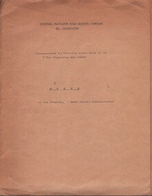
Document - MCCOLL, RANKIN AND STANISTREET COLLECTION: CENTRAL NAPOLEON GOLD MINING CO. N.L, 23rd July 1934
... History House 11 Mackenzie Street Bendigo goldfields ORGANIZATION Business industry - mining McColl Rankin & Stanistreet mining gold mining Central Napoleon Document: Manilla folder, print on front typed, green ribbon holding document together and in folder, first page with documents name and also has an embossed logo stamped on right side of page 3/4 way down 'Legislative Council Victoria' with royal crest in centre, Embossed stamp on each page, Rules of Central Napoleon GM before incorporation, 26 pages plus cover Certificate second last page, last page schedule of share holders, markings on front cover read 'Central Napoleon Gold Mining Company No Liability', 'Incorporated in Victoria under part 11 of ''The Companies Act 1928'' RULES of the Company Made before Incorporation'. ...Document: Manilla folder, print on front typed, green ribbon holding document together and in folder, first page with documents name and also has an embossed logo stamped on right side of page 3/4 way down 'Legislative Council Victoria' with royal crest in centre, Embossed stamp on each page, Rules of Central Napoleon GM before incorporation, 26 pages plus cover Certificate second last page, last page schedule of share holders, markings on front cover read 'Central Napoleon Gold Mining Company No Liability', 'Incorporated in Victoria under part 11 of ''The Companies Act 1928'' RULES of the Company Made before Incorporation'.organization, business, industry - mining, mccoll rankin & stanistreet, mining, gold mining, central napoleon -
 Bendigo Historical Society Inc.
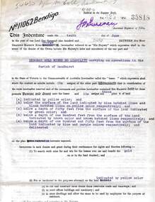
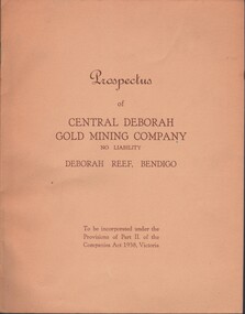
Document - MCCOLL, RANKIN AND STANISTREET COLLECTION: CENTRAL DEBORAH GOLD MINE NL: PROSPECTUS, 1939
... History House 11 Mackenzie Street Bendigo goldfields ORGANIZATION Business central deborah gold mine McColl Rankin & Stanistreet Collection: Central Deborah Gold Mine NL. Gold mining Document: McColl, Rankin & Stanistreet Collection: Central Deborah Gold Mine NL - 4 copies of prospectus. Buff covered booklet. Written on front ' Prospectus of Central Deborah Gold Mining Company No Liability Deborah Reef, Bendigo. To be incorporated under the Provisions of Part II of the companies Act 1938. Victoria ...Document: McColl, Rankin & Stanistreet Collection: Central Deborah Gold Mine NL - 4 copies of prospectus. Buff covered booklet. Written on front ' Prospectus of Central Deborah Gold Mining Company No Liability Deborah Reef, Bendigo. To be incorporated under the Provisions of Part II of the companies Act 1938. Victoria.' Details capital, proposed directors and manager. Contains map of Central and North Deborah mines and Monument Hill.organization, business, central deborah gold mine, mccoll, rankin & stanistreet collection: central deborah gold mine nl. gold mining -
 Bendigo Historical Society Inc.
Document - MCCOLL, RANKIN AND STANISTREET COLLECTION: NORTH VIRGINIA GOLD MINING COMPANY NL, MORTgage, 1940
... History House 11 Mackenzie Street Bendigo goldfields ORGANIZATION Business gold mine McColl Rankin & Stanistreet North Virginia Gold Mining Company NL Mortgage discharge of mortgage satisfaction piece Honourable Edmond John Hogan in his capacity as Minister of Mines for the State of Victoria. ...McColl Rankin & Stanistreet, North Virginia Gold Mining Company NL, Mortgage. a/ 960 pounds agreed to be lent by The Honourable John Hogan Minister of Mines for Victoria. Dated: 8/1/1940. Signed J B ?, A Mackay & Stanistreet, also E J Hogan & ? Brown JP. Marked Time of its production 5/6//1940. b/ the sum of 500 pounds agreed to be lent by the Honourable Edmond John Hogan in his capacity as Minister of Mines for the State of Victoria. Frank G Menzies Crown Solicitor. Initials of ?, ? & ? on page one for alteration. Signatures: J Michelson?, A Mackay & Stanistreet also Jen Brown JP & E J Hogan. Dated 14/7/1941. Time of its production for registration 16/7/1941. c/ Letter from Mines Department to McColl Rankin & Stanistreet Re: Discharge of mortgage documents and satisfaction Pieces. Mortgage Documents No. 792210 & 808852.Lease document No. 10859 Bendigo. Bills of Sale. Signed: Ron? R Neal (secretary). Dated: 26/7/1951. (c is attached to d). d/ Discharge Of Mortgage. The Honourable George Colin Moss in his capacity as Minister of Mines discharged North Virginia Gold Mining Company No LB in the said Mortgage. Dated1951. Signed A E ? & George C Moss, 2 copies. e/ Satisfaction Piece. The Honourable George Colin Moss Minister of Mines Victoria of a Bill of Sale dated 18/1/1940 between North Virginia Gold Mining Company NL. Signed George Colin Moss & A E ? 2 copies.organization, business, gold mine, mccoll rankin & stanistreet, north virginia gold mining company nl, mortgage discharge of mortgage satisfaction piece honourable edmond john hogan in his capacity as minister of mines for the state of victoria. frank g menzies crown solicitor. -
 Bendigo Historical Society Inc.
Document - MCCOLL, RANKIN AND STANISTREET COLLECTION: CENTRAL NAPOLEON GOLD MINING CO. N.L, 1934-1950
... History House 11 Mackenzie Street Bendigo goldfields ORGANIZATION Business industrial - mining McColl Rankin & Stanistreet mining gold mining Central Napoleon Pink Manilla Folder containing: General Correspondance Letters to and from suppliers of machinery and parts e.g. Electricity Supply Departments, Fred Milne & Son (Engineers), Thompsons Engineering & Pipe Co.Ltd, Miller & Co Machinery Pty Ltd, Alfred J Jorgenson, Bingle Machinery Co, The Richardson Gears Pty Ltd, Buckell & Jeffrey Pty Ltd, Commercial Union Assuarance Company Limited, Bendigo Machinery & Trading Co Pty Ltd, Ronaldson Bros & Tippett Pty Ltd (including a picture of a drawlift pump), J.G. Bloomfield, Ronaldson - Tippett list of 4583 Machines in Victoria ...Pink Manilla Folder containing: General Correspondance Letters to and from suppliers of machinery and parts e.g. Electricity Supply Departments, Fred Milne & Son (Engineers), Thompsons Engineering & Pipe Co.Ltd, Miller & Co Machinery Pty Ltd, Alfred J Jorgenson, Bingle Machinery Co, The Richardson Gears Pty Ltd, Buckell & Jeffrey Pty Ltd, Commercial Union Assuarance Company Limited, Bendigo Machinery & Trading Co Pty Ltd, Ronaldson Bros & Tippett Pty Ltd (including a picture of a drawlift pump), J.G. Bloomfield, Ronaldson - Tippett list of 4583 Machines in Victoria & addfor crude oil engine, A.H McDonald & Co Pty Ltd & ad for crude oil engine, E Treliving letter & list of second hand materials for sale, J. Edwards-Retallack Machinery Manufacturers Representative, Hume & Iser Pty Ltd Timber & Hardware Merchants, Bendigo Timber Co Timber & Hardware Merchants, markings read 'Cent. Napoleon G.M.Co N.L Machinery', Correspondance dating from 16 July 1934 - 26 October 1950.organization, business, industrial - mining, mccoll rankin & stanistreet, mining, gold mining, central napoleon -
 Bendigo Historical Society Inc.
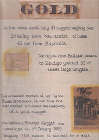
Document - 'GOLD' POSTER WITH DESCRIPTION OF NUGGETS
... History House 11 Mackenzie Street Bendigo goldfields DOCUMENT gold Poster heading - 'Gold' - 'In the whole world, only 47 nuggets weighing over 30lbs Troy have been recorded. Of these 40 are from Australia. The region from Ballarat around to Bendigo yielded 32 of these large nuggets. This monument erected in 1897 by the Mines Department, is the only one ever erected to honour the discovery of a gold nugget. The 'Welcome Stranger' nugget was unearthed on 5th February, 1869, weighing 2316 ounces and it was sold for 9.553 pounds'. Poster includes a map of Victoria depicting the main gold mining ...Poster heading - 'Gold' - 'In the whole world, only 47 nuggets weighing over 30lbs Troy have been recorded. Of these 40 are from Australia. The region from Ballarat around to Bendigo yielded 32 of these large nuggets. This monument erected in 1897 by the Mines Department, is the only one ever erected to honour the discovery of a gold nugget. The 'Welcome Stranger' nugget was unearthed on 5th February, 1869, weighing 2316 ounces and it was sold for 9.553 pounds'. Poster includes a map of Victoria depicting the main gold mining areas, also mention of gypsum, and tin in northern Victoria. A photo of the monument to the discovery of the 'Welcome Stranger' nugget found 1 1/4 miles from Moliagul in the bottom corner.document, gold -
 Bendigo Historical Society Inc.
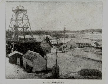
Photograph - UNITED DEVONSHIRE
... History House 11 Mackenzie Street Bendigo goldfields MINING Surface equipment united devonshire Bendigo mines and mining poppet head Eaglehawk Devonshire Valley mining sheds Black and white photograph of an image. Poppet head, overhead tramway, mine buildings, dam. Inscriptions: on front at bottom - printed 'United Devonshire'. Inscriptions: on back, type written. 'The 'United Devonshire' - New Chum Line of Reef'. Situated in the Devonshire Valley immediately south of Victoria ...Black and white photograph of an image. Poppet head, overhead tramway, mine buildings, dam. Inscriptions: on front at bottom - printed 'United Devonshire'. Inscriptions: on back, type written. 'The 'United Devonshire' - New Chum Line of Reef'. Situated in the Devonshire Valley immediately south of Victoria St, Eaglehawk. Was the leading mine in the field in the years 1883-4 and 1885 during which time it produced 65,898 oz of gold and paid $(?)399,800 in dividends. This mine was then situated on what in January, 1902, became the West Shaft. The Company was then amalgamated with the 'Princess Alexandra' (approx 100 yds further east) which then became the Main Shaft of the 'United Devonshire'. All typed on paper and glued to back of image. Handwritten in ball point pen 'A Richardson, 29 Harrison St, Bendigo'.mining, surface equipment, united devonshire, bendigo, mines and mining, poppet head, eaglehawk, devonshire valley, mining sheds -
 Bendigo Historical Society Inc.
Photograph - UNITED DEVONSHIRE
... History House 11 Mackenzie Street Bendigo goldfields MINING Surface equipment united devonshire Bendigo mines and mining mines poppet head mining sheds Devonshire Valley Eaglehawk Black and white photograph of an image. Poppet head, overhead tramway, mine buildings, dam. Inscriptions: on front at bottom - printed 'United Devonshire'. Inscriptions: on back, type written. 'The 'United Devonshire' - New Chum Line of Reef'. Situated in the Devonshire Valley immediately south of Victoria ...Black and white photograph of an image. Poppet head, overhead tramway, mine buildings, dam. Inscriptions: on front at bottom - printed 'United Devonshire'. Inscriptions: on back, type written. 'The 'United Devonshire' - New Chum Line of Reef'. Situated in the Devonshire Valley immediately south of Victoria St, Eaglehawk. Was the leading mine in the field in the years 1883-4 and 1885 during which time it produced 65,898 oz of gold and paid $(?)399,800 in dividends. This mine was then situated on what in January, 1902, became the West Shaft. The Company was then amalgamated with the 'Princess Alexandra' (approx 100 yds further east) which then became the Main Shaft of the 'United Devonshire'. All typed on paper and glued to back of image. Handwritten in ball point pen 'A Richardson, 29 Harrison St, Bendigo'.mining, surface equipment, united devonshire, bendigo, mines and mining, mines, poppet head, mining sheds, devonshire valley, eaglehawk -
 Bendigo Historical Society Inc.
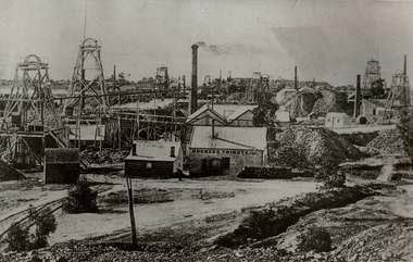
Photograph - MINING SITE
... History House 11 Mackenzie Street Bendigo goldfields MINING Surface equipment surface site Bendigo mines and mining mines mining poppet heads mine buildings Black and white photograph of many mines. At least 12 poppet heads and four chimneys. Mine buildings, mullock heaps. Inscriptions: in image, on building 'Duchess Tribute CoMc'. In margin at BL in pencil '12'. On back in pencil - '12', in ball point pen 'Devonshire Group'. In black ink 'MNG 22'. Blue circular stamp 'Royal Historical Society of Victoria ...Black and white photograph of many mines. At least 12 poppet heads and four chimneys. Mine buildings, mullock heaps. Inscriptions: in image, on building 'Duchess Tribute CoMc'. In margin at BL in pencil '12'. On back in pencil - '12', in ball point pen 'Devonshire Group'. In black ink 'MNG 22'. Blue circular stamp 'Royal Historical Society of Victoria, Bendigo Branch'.mining, surface equipment, surface site, bendigo, mines and mining, mines, mining, poppet heads, mine buildings -
 Bendigo Historical Society Inc.
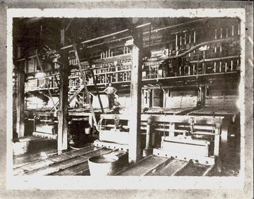
Photograph - CARLISLE BATTERY
... History House 11 Mackenzie Street Bendigo goldfields MINING Crushing & milling Carlisle Battery Bendigo mines and mining mines mine mining battery crushing battery Black and white photograph of older photograph. Machinery, wheels, driving belts, hammers of a crushing battery. Inscriptions: on back - 'Carlisle Battery / Crushing Battery', 'Royal Historical Society of Victoria ...Black and white photograph of older photograph. Machinery, wheels, driving belts, hammers of a crushing battery. Inscriptions: on back - 'Carlisle Battery / Crushing Battery', 'Royal Historical Society of Victoria, Bendigo Branch'.mining, crushing & milling, carlisle battery, bendigo, mines and mining, mines, mine, mining, battery, crushing battery -
 Bendigo Historical Society Inc.
Album - FORTUNA COLLECTION: ALBUM - PHOTOGRAPHS OF FORTUNA, BENDIGO
... History House 11 Mackenzie Street Bendigo goldfields Fortuna Villa George Lansell purchased Ballerstadt's claim on Victoria Hill for £30,000. The purchase included a two-story villa. Lansell extended the building in the following years with the last major additions in 1904 - 1905. Architects included Vahland and Getzschmann, W.C. Vahland and William Beebe. Contractors include J.K. McLean and W.H.Johns. PLACE Fortuna photo album George Lansell Gold mining ...Fortuna Villa George Lansell purchased Ballerstadt's claim on Victoria Hill for £30,000. The purchase included a two-story villa. Lansell extended the building in the following years with the last major additions in 1904 - 1905. Architects included Vahland and Getzschmann, W.C. Vahland and William Beebe. Contractors include J.K. McLean and W.H.Johns.Album, covered in blue fabric. Printed in gold lettering on front 'Photographs of 'Fortuna' Bendigo". Album contains 48 black and white photos of George Lansell's home, Fortuna, taken in late 1800s, ranging from photos of the interior of the house, the garden and the lake.place, fortuna, photo album, george lansell, gold mining, ballerstedt, victoria hill, historic building -
 Bendigo Historical Society Inc.
Photograph - LITTLE 180 MINE, 1920 / 1933
... History House 11 Mackenzie Street Bendigo goldfields Initially named Lansells Little 180 Mine was part of the Victoria Hill mining area. ...Initially named Lansells Little 180 Mine was part of the Victoria Hill mining area. It was operated by George Lansell until his death in 1906 but continued operation by his estate until 1927 when it was sold. The mine closed in the early 1930's.black And white photo - 2 adult males in foreground, 1 wearing hat, waiscoat, 1 wearing hat, 3 piece suit. Corrugated iron building behind men with double wooden doors, wooden shutters as windows, large wooden reel ( for cable ) at right. Saw horse at left foreground. On back ' Mine Manager/Little 180 Bendigo/1920.'cottage, miners -
 Bendigo Historical Society Inc.
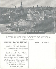
Photograph - HUSTLERS ROYAL RESERVE NO. 2 (POSTCARDS)
... History House 11 Mackenzie Street Bendigo goldfields PLACE Mining site hustlers royal reserve no 2 Hustlers Royal Reserve No. 2 (Postcards of the Royal Historical Society of Victoria - Bendigo Branch. 10 identical postcards showing mine and Pall Mall, Bendigo. ...Hustlers Royal Reserve No. 2 (Postcards of the Royal Historical Society of Victoria - Bendigo Branch. 10 identical postcards showing mine and Pall Mall, Bendigo. On reverse: LH side with details of locality, shaft, poppet and engine details, gold yield and dividends. RH Side - blank for addresseeplace, mining site, hustlers royal reserve no 2