Showing 25 items matching "montmorency - maps"
-
 Greensborough Historical Society
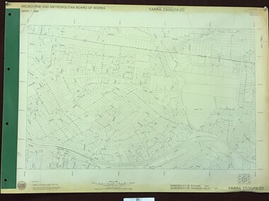
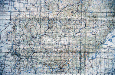
Map, Melbourne and Metropolitan Board of Works. Survey Division, MMBW, Yarra 2500 / 14.20. Montmorency, Sherbourne Road, 1977_06
... ...montmorency - maps...Yarra 2500 [base map] 14.20. Montmorency, Sherbourne Road. Municipality of Diamond Valley 257 and Eltham 238. ...MMBW, Yarra 2500 / 14.20. Montmorency, Sherbourne Road. Map Melbourne and Metropolitan Board of Works. ...Melbourne and Metropolitan Board of Works. Yarra 2500 [base map] 14.20. Montmorency, Sherbourne Road. Municipality of Diamond Valley 257 and Eltham 238. Prominent streets: Sherbourne Road, Karingal Drive and Calrossie Avenue. Features include Montmorency Station and Meruka Park.MMBW Map in 1:2500 [scale] series. Cream parchment with green tape reinforcing on edges and punched holes on left edge.mmbw, melbourne and metropolitan board of works, shire of diamond valley, montmorency - maps -
 Greensborough Historical Society
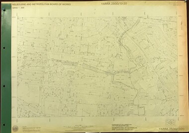
Map, Melbourne and Metropolitan Board of Works. Survey Division, MMBW, Yarra 2500 / 13.20. Greensborough, Montmorency and Watsonia, 1979_03
... ...montmorency - maps...Yarra 2500 [base map] 13-20. Greensborough, Montmorency and Watsonia. Parishes of Nillumbik 3310 and Keelbundora 2856. ...Includes Montmorency High School. mmbw melbourne and metropolitan board of works shire of diamond valley greensborough - maps montmorency - maps watsonia - maps MMBW Map in 1:2500 [scale] series. ...Melbourne and Metropolitan Board of Works. Yarra 2500 [base map] 13-20. Greensborough, Montmorency and Watsonia. Parishes of Nillumbik 3310 and Keelbundora 2856. Municipalities of Eltham 238 and Diamond Valley 257. Prominent streets include: Nell Street, Nepean Street and Alexandra Street. Includes Montmorency High School.MMBW Map in 1:2500 [scale] series. Cream parchment with green tape reinforcing on edges and punched holes on left edge.mmbw, melbourne and metropolitan board of works, shire of diamond valley, greensborough - maps, montmorency - maps, watsonia - maps -
 Greensborough Historical Society
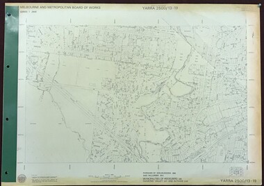
Map, Melbourne and Metropolitan Board of Works. Survey Division, MMBW, Yarra 2500 / 13.19. Lower Plenty, Montmorency, Yallambie, 1979_02
... ...montmorency - maps...Yarra 2500 [base map] 13-19. Lower Plenty, Montmorency, Yallambie. Parishes of Keelbundora 2856 and Nillumbik 3310. ...Lower Plenty, Montmorency, Yallambie. Map Melbourne and Metropolitan Board of Works. ...Melbourne and Metropolitan Board of Works. Yarra 2500 [base map] 13-19. Lower Plenty, Montmorency, Yallambie. Parishes of Keelbundora 2856 and Nillumbik 3310. Municipalities of Heidelberg 228, Diamond Valley 257 and Eltham 238. Prominent streets include: Elder Street, Para Road, and Main Road Lower Plenty. Includes Watsonia Army Barracks.MMBW Map in 1:2500 [scale] series. Cream parchment with green tape reinforcing on edges and punched holes on left edge.mmbw, melbourne and metropolitan board of works, shire of diamond valley, montmorency - maps, yallambie - maps, lower plenty - maps -
 Eltham District Historical Society Inc
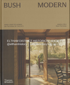
Book, Jessica Lillico, Bush Modern: Hand-crafted homes on the edge of the city, 4 Nov. 2025
... Contents: Bush modern locations (map) Grounded in simplicity by Jessica Lillico and Sean Fennessy Time and place by Morag Fraser Houses featured - Stonygrad 1940, North Warrandyte Fraser-Jackson House 1947/1977, Montmorency Busst House 1948, Eltham Burstall House 1950, Montmorency Wright House II 1960, North Warrandyte Collis House 1966, Eltham Diskin House 1967, Eltham Redfern House 1967, North Warrandyte River Bend 1968/2022, Garambi Baan, Eltham Fisher House 1969, Warrandyte Borrack House 1970, Plenty Valley Fiddlers Elbow 1970, North Warrandyte Light Well House 1972, Donvale Birrarung House 1974, Garambi Baan, Eltham High Noon 1974, North Warrandyte Monty Sibbel 1975/2022, Montmorency Provan House 1976/2021, North Warrandyte Pizzey House 1977, Eltham Pittard House 1978, Eltham Gray House 1980, Eltham Carol Ann House 1989, Bend of Islands Wattle Glen 1999, Wattle Glen Big Hill 2001, Christmas Hills ...Contents: Bush modern locations (map) Grounded in simplicity by Jessica Lillico and Sean Fennessy Time and place by Morag Fraser Houses featured - Stonygrad 1940, North Warrandyte Fraser-Jackson House 1947/1977, Montmorency Busst House 1948, Eltham Burstall House 1950, Montmorency Wright House II 1960, North Warrandyte Collis House 1966, Eltham Diskin House 1967, Eltham Redfern House 1967, North Warrandyte River Bend 1968/2022, Garambi Baan, Eltham Fisher House 1969, Warrandyte Borrack House 1970, Plenty Valley Fiddlers Elbow 1970, North Warrandyte Light Well House 1972, Donvale Birrarung House 1974, Garambi Baan, Eltham High Noon 1974, North Warrandyte Monty Sibbel 1975/2022, Montmorency Provan House 1976/2021, North Warrandyte Pizzey House 1977, Eltham Pittard House 1978, Eltham Gray House 1980, Eltham Carol Ann House 1989, Bend of Islands Wattle Glen 1999, Wattle Glen Big Hill 2001, Christmas Hills Stonygrad Fraser-Jackson House Busst House Burstall House Wright House II Collis House Diskin House Redfern House River Bend Fisher House Borrack House Fiddlers Elbow Light Well House Birrarung House High Noon Monty Sibbel Provan House Pizzey House Pittard House Gray House Carol Ann House Wattle Glen Big Hill Inside front cover in ink: "Enjoy! ...From the publisher Thames & Hudson Australia's website: "In the bushy north-eastern fringe of Melbourne, an enduring, uniquely Australian architectural aesthetic has been quietly gaining recognition. Emerging out of necessity in the post-war years, it reimagined the sleek ideals of modernism through the lens of the local landscape. Simple homes built 'of the land' from mud bricks and recycled timber captured the mood of those searching for an alternative way of life close to nature. The movement gathered momentum in the counter-cultural 1960s and culminated in near-mainstream popularity in the 1970s. After a few decades where brown lost appeal in favour of white-washed minimalism, the style in all its warm, earthy glory is once again being embraced and revived by a new generation Through evocative photography by Sean Fennessy, personal stories and architectural insights, Bush Modern explores the timeless appeal of these character-filled homes: tactile, grounded and deeply in tune with their environment." Contents: Bush modern locations (map) Grounded in simplicity by Jessica Lillico and Sean Fennessy Time and place by Morag Fraser Houses featured - Stonygrad 1940, North Warrandyte Fraser-Jackson House 1947/1977, Montmorency Busst House 1948, Eltham Burstall House 1950, Montmorency Wright House II 1960, North Warrandyte Collis House 1966, Eltham Diskin House 1967, Eltham Redfern House 1967, North Warrandyte River Bend 1968/2022, Garambi Baan, Eltham Fisher House 1969, Warrandyte Borrack House 1970, Plenty Valley Fiddlers Elbow 1970, North Warrandyte Light Well House 1972, Donvale Birrarung House 1974, Garambi Baan, Eltham High Noon 1974, North Warrandyte Monty Sibbel 1975/2022, Montmorency Provan House 1976/2021, North Warrandyte Pizzey House 1977, Eltham Pittard House 1978, Eltham Gray House 1980, Eltham Carol Ann House 1989, Bend of Islands Wattle Glen 1999, Wattle Glen Big Hill 2001, Christmas Hills Inside front cover in ink: "Enjoy! Jess & Sean"stonygrad, fraser-jackson house, busst house, burstall house, wright house ii, collis house, diskin house, redfern house, river bend, fisher house, borrack house, fiddlers elbow, light well house, birrarung house, high noon, monty sibbel, provan house, pizzey house, pittard house, gray house, carol ann house, wattle glen, big hill -
 Eltham District Historical Society Inc
Document - Property Binder, Eltham Town Square, Commercial Place, Eltham
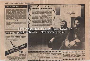
... Plan: Eltham Town Centre property Acquisition, Shire of Eltham March 1994 Businesses Arthur Street Bible Street Commercial Place Dudley Street Eltham Franklins Supermarket Luck Street Main Road Map McEwans Pryor Street Safeway Supermarket Apex Club Bronwyn Ryall Keith Ryall Zig Zag Road Cr Bob Manuell Cr Robert Allen Det Sgt Noel Murphy Eltham Chamber of Commerce Eltham Police Eltham Shire Council Eltham Town Square Lorraine Manuell Pauline Toner MP Robert Manuell Rodney Roscholler Shire Planner VicRail Elections H&J White General Store Hurstbridge Leslie Bowker Main Street Mrs Marshall Pam Lawson Robert Marshall Rosemary Tovey Central Park Comfort Station Eltham Little Theatre Montmorency Public Toilets Rotex Cinema Were Street Miscellaneous clippings, notes, photocopies, etc held on the subject property. ...1. Dreams to be reality, The Valley Voice, 15 August 1979, p2 - announcement of proposed town square of 1800 square metres of shop area and open courtyard to be sited in the carpark between Arthur Street and Pryor street. The plans also included tree-lined walkways from both Arthur Street and a pededstrian footbridge across Main Road leading to aregular open-air market and tavern. Shop owners facing Main Road were to be encouraged to turn their businesses towards the square. On reverse side - 'General' Marshall and his troops; Valley votes in five new faces, The Valley Voice, 15 August 1979, p1 - picture showing newly elected Cr Robert Marshall 2. Square plan on display, Diamond Valley News, Tuesday, June 23, 1981, p1 - Council's prefered proposal on display to the public. On same page a story about the son of Cr Bob Manuell being attacked on the train from the city. On reverse side - Helping people - here and abroad by Marguerite Marshall, Diamond Valley News, Tuesday, June 23, 1981, p2 - about Keith Ryall of Zig Zag Road, the Apex international councillor for Australia 3. Plan: Eltham Town Centre property Acquisition, Shire of Eltham March 1994businesses, arthur street, bible street, commercial place, dudley street, eltham, franklins supermarket, luck street, main road, map, mcewans, pryor street, safeway supermarket, apex club, bronwyn ryall, keith ryall, zig zag road, cr bob manuell, cr robert allen, det sgt noel murphy, eltham chamber of commerce, eltham police, eltham shire council, eltham town square, lorraine manuell, pauline toner mp, robert manuell, rodney roscholler, shire planner, vicrail, elections, h&j white general store, hurstbridge, leslie bowker, main street, mrs marshall, pam lawson, robert marshall, rosemary tovey, central park, comfort station, eltham little theatre, montmorency, public toilets, rotex cinema, were street -
 Greensborough Historical Society
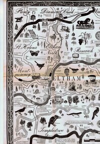
Map, George W. Bell, Eltham Warrandyte and environs: a visitor's guide map: centenary souvenir. 2nd ed, 1994c
... Greensborough Historical Society 34A Glenauburn Road Lower Plenty Lower Plenty melbourne Tourist guide to historic and other features in the Eltham Warrandyte area and environs, warrandyte eltham st helena montmorency A2, black & white, folded 3 times to A5, printed on one side Eltham Warrandyte and environs: a visitor's guide map: centenary souvenir. 2nd ed. ...Tourist guide to historic and other features in the Eltham Warrandyte area and environs, A2, black & white, folded 3 times to A5, printed on one sidewarrandyte, eltham, st helena, montmorency -
 Greensborough Historical Society
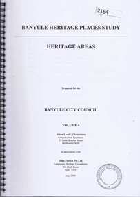
Book, Banyule Heritage Places Study. Vol. 4: Heritage Areas, 1999_07
... Were Street Montmorency is mentioned. heritage places were street heidelberg ivanhoe eaglemont 63 pages, col. illus., maps. ...This volume (4) of the Banyule Heritage Places Study: Heritage Areas deals mainly with areas in the Heidelberg, Eaglemont and Ivanhoe areas. Were Street Montmorency is mentioned.63 pages, col. illus., maps.heritage places, were street, heidelberg, ivanhoe, eaglemont -
 Greensborough Historical Society
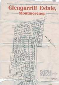
Map, Glengarriff Estate Montmorency, 1938c
... Bordered by Sherbourne Avenue, Calrossie Avenue, Montmorency Station and Price Avenue glengarriff estate montmorency sherbourne avenue montmorency calrossie avenue montmorency price avenue montmorency montmorency station Colour photocopy of subdivision map, on two A3 sheets Glengarriff Estate Montmorency Map T. ...Estate Agent's plan of Glengarriff Estate, Montmorency, covering LPs 11334 and 11451. Bordered by Sherbourne Avenue, Calrossie Avenue, Montmorency Station and Price AvenueColour photocopy of subdivision map, on two A3 sheets glengarriff estate montmorency, sherbourne avenue montmorency, calrossie avenue montmorency, price avenue montmorency, montmorency station -
 Greensborough Historical Society
Folder, Ian Bennetts, Is there a pattern to the distribution of burglaries and thefts reported to the Greensborough police station, and what factors may influence this? by Ian Bennetts, 1990_
... Montmorency Secondary College, 1990. Investigates whether there a pattern to the distribution of burglaries and thefts reported to the Greensborough police station, and what factors may influence this? by Ian Bennetts thefts greensborough police - greensborough Victorian Police logo on title page. 72 p. spiral bound loose leaf folder. Typescript, coloured maps ...Year 12 Geography individual research project, Montmorency Secondary College, 1990. Investigates whether there a pattern to the distribution of burglaries and thefts reported to the Greensborough police station, and what factors may influence this? by Ian Bennetts72 p. spiral bound loose leaf folder. Typescript, coloured maps and diagramsVictorian Police logo on title page.thefts, greensborough, police - greensborough -
 Montmorency–Eltham RSL Sub Branch
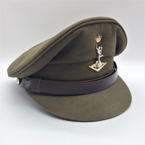
Cap, Peaked, Royal Australian Signals, 1988, 1988
... Montmorency–Eltham RSL Sub Branch Petrie Park 16 Mountain View Road Montmorency melbourne Standard issue peaked cap for 1988. headgear cap Australian Government Clothing Factory and logo Size /|\ 56 VIC 1988 (Note - no personal markings) Peaked khaki cloth cap with brown 18mm leather chin strap with two 13mm AMF gilt buttons (crown and map only). ...Standard issue peaked cap for 1988.Peaked khaki cloth cap with brown 18mm leather chin strap with two 13mm AMF gilt buttons (crown and map only). Khaki cloth covered peak. Royal Aust. Signals cap badge. Brown leather sweat band. Plastic covered, grey cloth liner with black stamped manufacturer's, etc. details. Australian Government Clothing Factory and logo Size /|\ 56 VIC 1988 (Note - no personal markings) headgear, cap -
 Montmorency–Eltham RSL Sub Branch
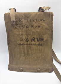
Equipment - Map Case No. 2, 1942
... Montmorency–Eltham RSL Sub Branch Petrie Park 16 Mountain View Road Montmorency melbourne This 1942-dated Map Case was still in use post-1982 when it was used by a member of the 5/6 Royal Victoria Regiment. ...This 1942-dated Map Case was still in use post-1982 when it was used by a member of the 5/6 Royal Victoria Regiment. This new Melbourne-based battalion was created on the 17 August 1982. Open-sided with a khaki canvas flap attached to a resin-impregnated board.. Hinged to the top edge is a celluloid cover. Four clips holds the cover (and any map) to the backing board. The flap is secured by a pair of Carr Australia press studs on the back. The underside of the flap has four loops for chinagraph pencils and a wider pocket and loop for a Protractor. Two brass buckles are provided for a web shoulder sling. C. G. Hartley & Co. 1942 ORMISTON 3200879 5/6 RVR -
 Montmorency–Eltham RSL Sub Branch
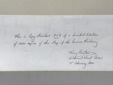
Map - Burma Railway Map (annotated)
... Montmorency–Eltham RSL Sub Branch Petrie Park 16 Mountain View Road Montmorency melbourne Fold-out sheet of paper showing and describing the details of locations along the railway; part of a numbered series of maps Map Burma Railway Map (annotated) ...Fold-out sheet of paper showing and describing the details of locations along the railway; part of a numbered series of maps -
 Montmorency–Eltham RSL Sub Branch
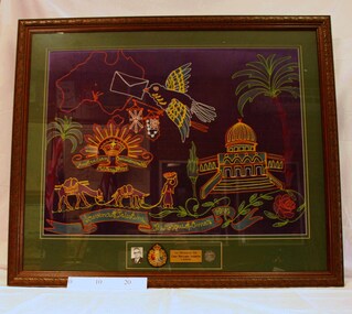
Souvenir - Framed World War 2 Embroidered Banner, WW2 Embroidered Souvenir, Estimated date 1941
... Montmorency–Eltham RSL Sub Branch Petrie Park 16 Mountain View Road Montmorency melbourne world war two embroidery 1941 souvenir palestine mosque omar 'In Honour of Corp Benjamin Ackroyd VX 5001. Souvenir of Palestine, The Mosque of Omar 1941.' Framed embroidered banner – a souvenir of World War Two. A multi-coloured map ...Framed embroidered banner – a souvenir of World War Two. A multi-coloured map of Australia, a bird carrying a letter, an Australian military badge, camels and a mosque are depicted on a dark blue background. At the bottom there is a photo, a 1939 associate badge, a dog tag and a brass plaque. 'In Honour of Corp Benjamin Ackroyd VX 5001. Souvenir of Palestine, The Mosque of Omar 1941.'world war two, embroidery, 1941, souvenir, palestine, mosque, omar -
 Montmorency–Eltham RSL Sub Branch
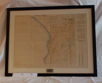
Map - Framed Japanese Map of Darwin Circa 1942, WW2 Japanese Map of Darwin, Estimated date 1940-41
... Montmorency–Eltham RSL Sub Branch Petrie Park 16 Mountain View Road Montmorency melbourne Returned to Australia, from America, where it had been brought back from Japan. darwin world war two japan australia 1942 1941 maps 'This map is a proof copy of a Japanese Reprint of an Australian map of Darwin.' ...Returned to Australia, from America, where it had been brought back from Japan.Framed map of Darwin with Japanese overprint.'This map is a proof copy of a Japanese Reprint of an Australian map of Darwin.'darwin, world war two, japan, australia, 1942, 1941, maps -
 Montmorency–Eltham RSL Sub Branch
Map - Framed 1915 Anzac Cove Map, Gallipoli, 1915.ANZAC Cove Map, 1915
... Montmorency–Eltham RSL Sub Branch Petrie Park 16 Mountain View Road Montmorency melbourne world war one anzac gallipoli 1915 anzac cove map dardenelles trench lines depth soundings landing areas Gallipoli - Anzac Cove World War One Map - 1915 A framed map depicting trench lines and the battlefields of the Gallipoli Campaign, 1915, made by the Survey Department Egypt. ...A framed map depicting trench lines and the battlefields of the Gallipoli Campaign, 1915, made by the Survey Department Egypt. Depth soundings of landing areas off Anzac Cove.Gallipoli - Anzac Cove World War One Map - 1915world war one, anzac, gallipoli, 1915, anzac cove, map, dardenelles, trench lines, depth soundings, landing areas -
 Montmorency–Eltham RSL Sub Branch
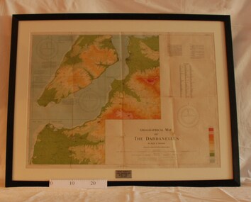
Map - Framed 1915 Map of Krithia, Gallipoli, 1915 Map of Krithia, Gallipolli, 1915
... Montmorency–Eltham RSL Sub Branch Petrie Park 16 Mountain View Road Montmorency melbourne world war one 1915 egypt map dardenelles krithia survey department turkey battlefields Krithia Peninsula (The Dardenelles) World War One - 1915 Map A framed topographical map of The Dardenelles produced from captured Turkish maps by the Egyptian Survey Department. ...A framed topographical map of The Dardenelles produced from captured Turkish maps by the Egyptian Survey Department. The main feature is the Krithia battlefield area in 1915.Krithia Peninsula (The Dardenelles) World War One - 1915 Mapworld war one, 1915, egypt, map, dardenelles, krithia, survey department, turkey, battlefields -
 Montmorency–Eltham RSL Sub Branch
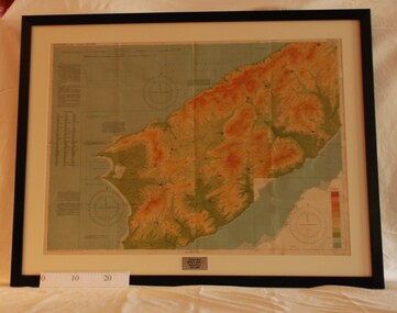
Map - Framed 1915 map of Sulva Bay, Gallipoli, 1915 Map of Silva Bay, Gallipoli, 1915
... Montmorency–Eltham RSL Sub Branch Petrie Park 16 Mountain View Road Montmorency melbourne This map was used in the Dardenelles Campaign 1915-1916. world war one middle east gallipoli 1915 map dardenelles sulva bay survey department battlefields egypt cairo Framed map showing the Sulva Bay area of the Gallipoli battlefield in 1915. 1915 Map of Silva Bay, Gallipoli Map Framed 1915 map of Sulva Bay, Gallipoli Survey Department - Egypt ...This map was used in the Dardenelles Campaign 1915-1916.Framed map showing the Sulva Bay area of the Gallipoli battlefield in 1915.world war one, middle east, gallipoli, 1915, map, dardenelles, sulva bay, survey department, battlefields, egypt cairo -
 Montmorency–Eltham RSL Sub Branch
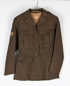
Uniform - Jacket, Khaki, Service Dress WW2 (Womens), 1943
... Montmorency melbourne Dress jacket worn by Corporal Kathleen Phyllis Gill from Toorak Hill, Casterton. Army No. VF345716 Unit LHQ (Mil. Sec) kathleen gill wool polyester women's dress jacket Lined women's khaki dress jacket. Long sleeved. Wool polyester. Four metal buttons down the front with the inscription Australian Military Forces with a map ...Dress jacket worn by Corporal Kathleen Phyllis Gill from Toorak Hill, Casterton. Army No. VF345716 Unit LHQ (Mil. Sec)Lined women's khaki dress jacket. Long sleeved. Wool polyester. Four metal buttons down the front with the inscription Australian Military Forces with a map of Australia in the center with a crown at the top of the map. Two hip pockets on the left and right with a flap on each. Two pleated pockets over the left and right breasts with flaps and small metal buttons inscribed Australian Military Forces with a map of Australia in the center with a crown at the top of the map. Australian Military Forces badge on the upper left lapel Two epaulets on the left and right shoulders with two small buttons inscribed Australian Military Forces with a map of Australia in the center with a crown at the top of the map. AWAS (Australian Women's Army Service) badges at the base of each epaulet. Corporal's stripes 6 cm down the right sleeve. Unit patch red over black - LHQ (Mill Sec). Two vertical belt loops at the back on the left and right. Pleat opening at the back. Horizontal strip of material inside the collar at the back of the neck to hang jacket. Tag sewn onto the lining at the back 2.5 cm down from the top stating - V 579 Made in Australia D. broad arrow D. 1943 Size kathleen gill, wool polyester, women's dress jacket -
 Montmorency–Eltham RSL Sub Branch
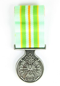
Medal - Military Kid Medallion, Foxhole Medals, After 2004
... Montmorency melbourne This medal was presented to the children of Victorian Wing - Warrant Officer and Non Commissioned Officers Academy Soldier who have served on operational deployments. As these young children endured an operational deployment of a parent who spent many months away from home in a foreign country representing the Australian Army. Following operations include Bougainville, East Timor, Indian Ocean, Solomon Islands, Meddle East Area, Afghanistan and Sinai. Presented by the Government to children whose parents had served overseas military kid military medal kids medal On reverse: "For perseverance on the home front during your parents deployment"; map ...This medal was presented to the children of Victorian Wing - Warrant Officer and Non Commissioned Officers Academy Soldier who have served on operational deployments. As these young children endured an operational deployment of a parent who spent many months away from home in a foreign country representing the Australian Army. Following operations include Bougainville, East Timor, Indian Ocean, Solomon Islands, Meddle East Area, Afghanistan and Sinai.Presented by the Government to children whose parents had served overseas Silver medal with pale green, yellow, orange and deeper green ribbon. It has a metal type container with a clear plastic front and also a black carry bag with Military Kid and print of medal on front. The design is based on the Australian Tri Service Logo. More detailed information can be found on Military Kids websiteOn reverse: "For perseverance on the home front during your parents deployment"; map of Australia (haut relief)military kid, military medal, kids medal -
 Montmorency–Eltham RSL Sub Branch
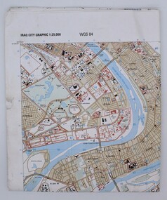
Map, Baghdad
... Montmorency–Eltham RSL Sub Branch Petrie Park 16 Mountain View Road Montmorency melbourne Prepared and published by the National Imagery and Mapping Agency Copyright 2003 by the United States Government map Iraq city Graphic 1:25,000. ...Prepared and published by the National Imagery and Mapping Agency Copyright 2003 by the United States GovernmentPaper, coloured The map is of Baghdad Iraq city Graphic 1:25,000. WGS 84 Edition 11- NIMA Series K941 Sheet 4 Map information as of 2001map -
 Eltham District Historical Society Inc
Folder, Pioneers & Painters; Shire of Eltham Historical Society research notes, background information, etc, 1969-1986, 1969-1986
... The public campaign received generous response and the material collected became the genesis for the Shire of Eltham Pioneers Photograph collection now held in partnership between Eltham District Historical Society and Yarra Plenty Regional Library (Eltham Library). a.g. thomas a.r. thomas alan marshall bridge road charles joseph latrobe council members d.w. lachlan eltham district road board eltham shire council ernie orford f. barrett francis rogerson g. bransprone james donaldson james johnston john bell john thomson joseph tice gellibrand lower plenty bridge m.b. watson main road map patrick turnbull peter morris pioneers and painters post office rev. longfield sepp shire of eltham pioneers photograph collection shire secretary st margaret's church thomas armstrong thomas bell thomas sweeney william bell (1796-1870) Centenary Celebrations Christmas Hills Clifton Pugh David Newbury Dudley Street Eltham gareth jones roberts Hurstbridge John Perceval Joy Peck Kangaroo Ground Kinglake Lower Plenty Luther Haley General Store Montmorency Neil Douglas Panton Hill Peter Glass Research (Vic.) ...Material pertaining to the production of a history of the Shire of Eltham, "Pioneers & Painters: One Hundred Years of Eltham and its Shire" in recognition of the shire's centenary in 1971 Item Title Caption 04768-1 Newspaper clipping - The Eltham of 1905; Gellibrand our first white visitor? Diamond Valley News, 24 June 1969, p5 04768-2 Newspaper clipping - The Eltham of 1905; Gellibrand our first white visitor? Heidelberger, 25 June 1969 04768-3 Notes on Eltham District Road Board Members 1866-1871 04768-4 Notes on Eltham District Road Board Members 1866-1871 04768-5 Map showing Gellibrand's likely route through district 12-13 February 1836 and Hoddles's route of Febrary 1838 04768-6 Notes by Shire Secretary, M.B. Watson regarding meeting with Reverend Longfield regarding history of St Margaret's Church 04768-7 Alan Marshall's notes from discussion with Mr. F. Barrett regarding SEPP images 611, 635 and 636 SEPP_0611 SEPP_0635 SEPP_0636 04768-8 Transcripts of letter from local residents to Charles Joseph Latrobe requesting a bridge over the Plenty River dated 10 April 1849 and his reply dated 5 May 1849; from Latrobe Library Archives - Land Branch Records 04768-9 Notes on history of Eltham Shire, Centenary events and publication of Pioneers & Painters for release in conjunction of opening of new Library 04768-10 Newspaper clipping - Glossy record of shire's romantic past and the people who made it by Fab Calafuri, Diamond Valley News, Tuesday, December 16, 1986, p18 SEPP_0755-3 Letter: Acknowledgement from Colin J. Bock, Eltham Shire Secretary to A.R. Thomas of Bendigo for copy of 1913 photograph of Shire of Eltham Councilors, 21 May 1973 A.R. Thomas' father Mr. A.G. Thomas, C.E., was the Shire Secretary at the time in 1913. Cross Ref: SEPP_0755 The idea to develop a book on the history of the Shire of Eltham to be edited by noted author, Alan Marshall in celebration of the shire's centenary was initiated in 1969. The Shire of Eltham Historical Society undertook significant research in conjunction with Alan Marshall locating material at various institutions and other societies; interviewing longer term residents and a public campaign through the local press to acquire photographic material for duplication and use in the book. The public campaign received generous response and the material collected became the genesis for the Shire of Eltham Pioneers Photograph collection now held in partnership between Eltham District Historical Society and Yarra Plenty Regional Library (Eltham Library).Paper documents of various sizes and newspaper clippingsa.g. thomas, a.r. thomas, alan marshall, bridge road, charles joseph latrobe, council members, d.w. lachlan, eltham district road board, eltham shire council, ernie orford, f. barrett, francis rogerson, g. bransprone, james donaldson, james johnston, john bell, john thomson, joseph tice gellibrand, lower plenty bridge, m.b. watson, main road, map, patrick turnbull, peter morris, pioneers and painters, post office, rev. longfield, sepp, shire of eltham pioneers photograph collection, shire secretary, st margaret's church, thomas armstrong, thomas bell, thomas sweeney, william bell (1796-1870), centenary celebrations, christmas hills, clifton pugh, david newbury, dudley street, eltham, gareth jones roberts, hurstbridge, john perceval, joy peck, kangaroo ground, kinglake, lower plenty, luther haley general store, montmorency, neil douglas, panton hill, peter glass, research (vic.), sheila ferguson, shire of eltham, st andrews, yarra glen -
 Eltham District Historical Society Inc
Slide - Photograph, Army Map, Yan Yean (Part, 1934), c.Aug. 1990
... Montmorency to the mountain roads of Kinglake. In the byways category are views of some iof the Shire's bicycle paths including then recently completed sections of the Main Yarra Trail at Lower Plenty. infrastructure roads Map shire of eltham 35mm colour positive transparency (1 of 37) Mount - Agfachrome Agfa CS System black 8 dots Army Map, Yan Yean (Part, 1934) Slide Photograph ...Part of a presentation, "Roads and Byways of the Shire of Eltham", by Russell Yeoman to the 12 September 1990 Society meeting. Slides shown included copies of old photos and recent images ranging from the suburban streets of Eltham and Montmorency to the mountain roads of Kinglake. In the byways category are views of some iof the Shire's bicycle paths including then recently completed sections of the Main Yarra Trail at Lower Plenty.35mm colour positive transparency (1 of 37) Mount - Agfachrome Agfa CS System black 8 dotsinfrastructure, roads, map, shire of eltham -
 Eltham District Historical Society Inc
Document - Folder, Montmorency Primary School No. 4112, 1982-2021
... Map: The five subdivisions of land which created the need for a school in 1921 2. Report on history of Montmorency Primary School 4112 (2 foolscap pages typed); Author unknown (part of an assignment completed for a Bachelor Arts in Australian Studies, Deakin University, graduated 1982. 3. ...Eltham District Historical Society Inc 728 Main Rd Eltham melbourne Includes a brief history of Montmorency Primary School up to 1970 Montmorency Primary School Montmorency State School No. 4112 Contents: 1. Map: The five subdivisions of land which created the need for a school in 1921 2. ...Includes a brief history of Montmorency Primary School up to 1970montmorency primary school, montmorency state school no. 4112 -
 Eltham District Historical Society Inc
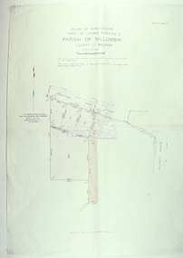
Slide - Photograph, Eltham Shire Council, Plan of Subdivision, Part of Crown Portion 3, Parish of Nillumbik, County of Bourke, 1969
... Eltham District Historical Society Inc 728 Main Rd Eltham melbourne Infrastructure Map Montmorency planning Rattray Road Subdivison Lots Reichelt Avenue C5C, Delbridge, 4 lots, Rattray Road, 4 August 1969 35mm colour positive transparency blue Agfacolour Service plastic mount Plan of Subdivision, Part of Crown Portion 3, Parish of Nillumbik, County of Bourke Slide Photograph Eltham Shire Council ...35mm colour positive transparency blue Agfacolour Service plastic mountC5C, Delbridge, 4 lots, Rattray Road, 4 August 1969infrastructure, map, montmorency, planning, rattray road, subdivison lots, reichelt avenue -
 Eltham District Historical Society Inc
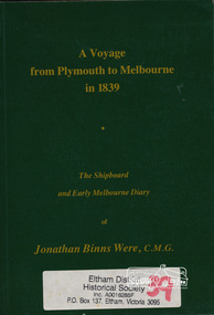
Book, A voyage from Plymouth to Melbourne in 1839 : the shipboard and early Melbourne diary of Jonathan Binns Were, 1964
... Montmorency possibly named for Were. "Were's were importers, exporters, and agents for shipping, land, cattle, sheep and wool. In 1851 they became brokers and buyers of gold, and in 1853 began to deal in shares." - ADB ship voyage early settlers plymouth england melbourne ISBN 0646002287 Hardback, no dust jacket; xv, 309 p. : ill., facsim., geneal. tables (folded), maps, ports. ; 20 cm. ...J B Were was associated with Henry Dendy. Were Street, Montmorency possibly named for Were. "Were's were importers, exporters, and agents for shipping, land, cattle, sheep and wool. In 1851 they became brokers and buyers of gold, and in 1853 began to deal in shares." - ADB Hardback, no dust jacket; xv, 309 p. : ill., facsim., geneal. tables (folded), maps, ports. ; 20 cm.ISBN 0646002287ship voyage, early settlers, plymouth england, melbourne