Showing 39 items matching "moorabool shire"
-
 Buninyong & District Historical Society
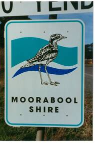
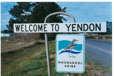
Photograph - Original Photograph, Mr. C.J. Brooks, Moorabool Shire sign closeup, September 1995
... Moorabool Shire sign closeup......Moorabool Shire...Colour photo, closeup of the Moorabool Shire sign on the Western outskirts of the township of Yendon...Buninyong & District Historical Society Old Court House, Buninyong Town Hall 313 Learmonth Street Buninyong goldfields Social, historical Example of the Moorabool Shire sign in the late twentieth century Road signs Yendon Moorabool Shire Streetscape Colour photo, closeup of the Moorabool Shire sign on the Western outskirts of the township of Yendon Moorabool Shire sign closeup Photograph Original Photograph Mr. ...Social, historicalExample of the Moorabool Shire sign in the late twentieth centuryColour photo, closeup of the Moorabool Shire sign on the Western outskirts of the township of Yendonroad signs, yendon, moorabool shire, streetscape -
 Buninyong & District Historical Society
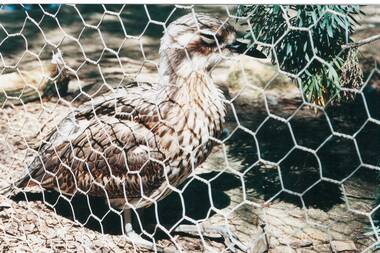
Photograph - Photograph of a Curlew, the symbol of Moorabool Shire, Photograph of a Curlew, a bird now extinct in this area
... Photograph of a Curlew, the symbol of Moorabool Shire. ...Photograph Photograph of a Curlew, the symbol of Moorabool Shire. ...Photograph of a Curlew, a bird now extinct in this area. Picture taken at Bulker's Winery, near Rutherglen in October 1997.bird, extinct in this area. -
 Buninyong Visitor Information Centre
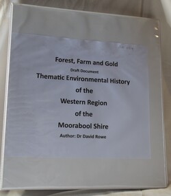
Document (item) - Information Folder, Forest, Farm and Gold: Thematic Environmental History
... Moorabool Shire...The heritage study includes historical chapters on the western region of Moorabool Shire, identifying buildings and sites of environmental significance. ...White, vinyl covered ring binder holding a copy of a report for Shire of Moorabool Heritage Study in 2010....Written by Dr David Rowe and Wendy Jacobs. Moorabool Shire Heritage Studies Buildings Heritage Sites Aboriginal history White, vinyl covered ring binder holding a copy of a report for Shire of Moorabool Heritage Study in 2010. ...The heritage study includes historical chapters on the western region of Moorabool Shire, identifying buildings and sites of environmental significance. Written by Dr David Rowe and Wendy Jacobs. moorabool shire, heritage studies, buildings, heritage sites, aboriginal history -
 Buninyong Visitor Information Centre
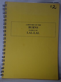
Document (item) - Booklet, Joan Ogilvie, A History of the Burns Family of Lal-Lal, Unknown
... Lal-Lal, Moorabool Shire, Victoria, Australia ...Written by Joan Ogilvie of Mount Clear. Gives the story of the Burns Family of Lal-Lal. lal-lal, burns family, family history -
 Buninyong & District Historical Society
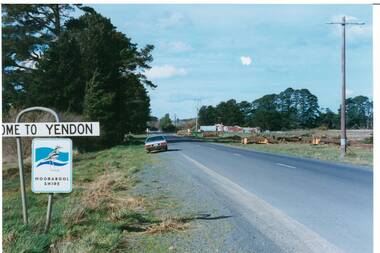
Photograph - Original Photograph, Mr. C.J. Brooks, Yendon township sign, September 1995
... ...Moorabool Shire...Buninyong & District Historical Society Old Court House, Buninyong Town Hall 313 Learmonth Street Buninyong goldfields Social, historical Yendon township sign taken in September 1995 showing the Moorabool Shire signage of that time Road signs Yendon Moorabool Shire Streetscape Colour photo, Welcome to Yendon Sign on the Western outskirts of the township Yendon township sign Photograph Original Photograph Mr. ...Social, historicalYendon township sign taken in September 1995 showing the Moorabool Shire signage of that timeColour photo, Welcome to Yendon Sign on the Western outskirts of the townshiproad signs, yendon, moorabool shire, streetscape -
 Buninyong & District Historical Society
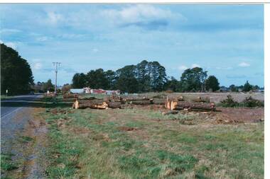
Photograph - Original Photograph, Mr. C.J. Brooks, Main street of Yendon from the West, September 1995
... ...Moorabool Shire...Buninyong & District Historical Society Old Court House, Buninyong Town Hall 313 Learmonth Street Buninyong goldfields Social, historical Example of the Moorabool Shire sign and the felling of trees for power company in the late twentieth century Road signs Yendon Moorabool Shire Streetscape Felled pinetrees Powercor Colour photo, of the Western outskirts of the township of Yendon showing 8-10 felled pine trees of the southern side of avenue Main street of Yendon from the West Photograph Original Photograph Mr. ...Social, historicalExample of the Moorabool Shire sign and the felling of trees for power company in the late twentieth centuryColour photo, of the Western outskirts of the township of Yendon showing 8-10 felled pine trees of the southern side of avenueroad signs, yendon, moorabool shire, streetscape, felled pinetrees, powercor -
 Buninyong & District Historical Society
Photograph - Original Photograph, Mr. C.J. Brooks, Main street of Yendon from the West showing felled pine trees, September 1995
... ...Moorabool Shire...Buninyong & District Historical Society Old Court House, Buninyong Town Hall 313 Learmonth Street Buninyong goldfields Social, historical Example of the felling of trees for power company in the late twentieth century Yendon Moorabool Shire Streetscape Felled pinetrees Powercor Colour photo, of the Western outskirts of the township of Yendon showing 8-10 felled pine trees from the southern side of avenue Main street of Yendon from the West showing felled pine trees Photograph Original Photograph Mr. ...Social, historicalExample of the felling of trees for power company in the late twentieth centuryColour photo, of the Western outskirts of the township of Yendon showing 8-10 felled pine trees from the southern side of avenueyendon, moorabool shire, streetscape, felled pinetrees, powercor -
 Buninyong & District Historical Society
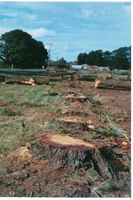
Photograph - Original Photograph, Mr. C.J. Brooks, Main street of Yendon from the West showing felled pine trees and tree stumps, September 1995
... ...Moorabool Shire...Buninyong & District Historical Society Old Court House, Buninyong Town Hall 313 Learmonth Street Buninyong goldfields Social, historical Example of the felling of trees for power company in the late twentieth century Yendon Moorabool Shire Streetscape Felled pinetrees Powercor Colour photo, of the Western outskirts of the township of Yendon showing felled pine trees and stumps Main street of Yendon from the West showing felled pine trees and tree stumps Photograph Original Photograph Mr. ...Social, historicalExample of the felling of trees for power company in the late twentieth centuryColour photo, of the Western outskirts of the township of Yendon showing felled pine trees and stumps yendon, moorabool shire, streetscape, felled pinetrees, powercor -
 Bacchus Marsh & District Historical Society
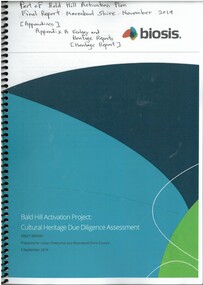
Booklet, Cultural Heritage Due Diligence Assessment Draft Report: Bald Hill Activation Project Final Report
... Paper copy obtained from digital PDF document downloaded from Moorabool Shire Council website on 17 May, 2025. ...Paper copy obtained from digital PDF document downloaded from Moorabool Shire Council website on 17 May, 2025. ...Bald Hill is a 120 hectare council reserve located in Darley, Bacchus Marsh. It overlooks the township of Bacchus Marsh and is one of the highest points in the township area. The reserve is undergoing ongoing planning and development for a range of recreational uses. As part of this planning a cultural heritage assessment was undertaken in 2019. This included assessment of the area for Aboriginal heritage. This assessment was part of the overall Bald Hill Activation Plan Final Report and forms an appendix to that report.Printed booklet. 39 pages. Spiral bound. Paper copy obtained from digital PDF document downloaded from Moorabool Shire Council website on 17 May, 2025. BMDHS Location: AR/SU5/Magazine Box 1Bald Hill is a 120 hectare council reserve located in Darley, Bacchus Marsh. It overlooks the township of Bacchus Marsh and is one of the highest points in the township area. The reserve is undergoing ongoing planning and development for a range of recreational uses. As part of this planning a cultural heritage assessment was undertaken in 2019. This included assessment of the area for Aboriginal heritage. This assessment was part of the overall Bald Hill Activation Plan Final Report and forms an appendix to that report. aboriginal australians bacchus marsh region history, aboriginal artifacts bacchus marsh region, heritage studies bacchus marsh victoria, bald hill bacchus marsh -
 Federation University Historical Collection
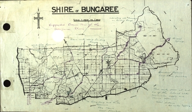
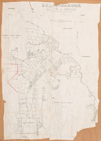
Plan, Shire of Bungaree
... The former Shire of Bungaree is now part of Moorabool Shire....Shire of Bungaree. Scale is 1 inch to 1 mile with the total distance approximately 40 miles. Includes Gong Gong Reservoir, Kirks Reservoir, White Swan Reservoir, Wilson's Reservois and Moorabool Reservoir. ...Includes Gong Gong Reservoir, Kirks Reservoir, White Swan Reservoir, Wilson's Reservois and Moorabool Reservoir. Shire of Bungaree Plan Plan ...The former Shire of Bungaree is now part of Moorabool Shire.Plan of the Shire of Bungaree. Scale is 1 inch to 1 mile with the total distance approximately 40 miles. Includes Gong Gong Reservoir, Kirks Reservoir, White Swan Reservoir, Wilson's Reservois and Moorabool Reservoir. Purple line in purple pencil indictaes suggested scenic tour of the Bungaree Shirebungaree, water supply, barkstead, humffray street, ballarat, doveton (north) stret, ballarat, ballarat water commission, great dividing range, wombat state forest, mineral water springs, gong gon reservoir, kirks reservoir -
 Ballan Shire Historical Society
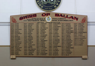
Memorabilia, Ballan Shire President's Board
... This Memorial Board lists all the Presidents of the old Ballan Shire and is a complete record from the creation of a Road District in 1862, then the creation of a Shire in 1864 through to when the Shire was amalgamated into the Moorabool Shire in 1994....Ballan Shire Historical Society 45-47 Steiglitz St Ballan goldfields This Memorial Board lists all the Presidents of the old Ballan Shire and is a complete record from the creation of a Road District in 1862, then the creation of a Shire in 1864 through to when the Shire was amalgamated into the Moorabool Shire in 1994. Ballan Shire President's Board. ...This Memorial Board lists all the Presidents of the old Ballan Shire and is a complete record from the creation of a Road District in 1862, then the creation of a Shire in 1864 through to when the Shire was amalgamated into the Moorabool Shire in 1994.A large memorial board listing all the Presidents of the Ballan Shire.See photographballan shire president's board., ballan local government -
 Bacchus Marsh & District Historical Society
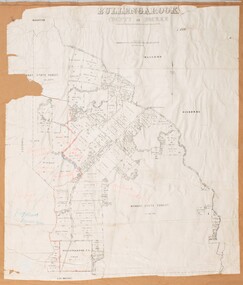
Map, Bullengarook Parish, County of Bourke
... This parish area is close to the Bacchus Marsh district and borders some of the areas contained within the former Bacchus Marsh Shire and present day Moorabool Shire....This parish area is close to the Bacchus Marsh district and borders some of the areas contained within the former Bacchus Marsh Shire and present day Moorabool Shire. Bullengarook Parish Maps A single page paper map showing the parish plan map for Bullengarook. ...An undated parish plan map for the parish of Bullegarook. This parish area is close to the Bacchus Marsh district and borders some of the areas contained within the former Bacchus Marsh Shire and present day Moorabool Shire.A single page paper map showing the parish plan map for Bullengarook. This parish area contains the locality of Bullengarook and parts of the Wombat State Forest and is close to the town of Gisborne. A cadastral map showing land ownership. The map is not dated but a very similar map held by the State Library of Victoria is estimated to date from about 1927. The map is pasted into a bound volume containing 76 maps or plans in total. High resolution digital image stored on BMDHS computer network. bullengarook parish maps -
 Bacchus Marsh & District Historical Society
Map, Bullengarook Parish, County of Bourke
... This parish area is close to the Bacchus Marsh district and borders some of the areas contained within the former Bacchus Marsh Shire and present day Moorabool Shire....This parish area is close to the Bacchus Marsh district and borders some of the areas contained within the former Bacchus Marsh Shire and present day Moorabool Shire. Bullengarook Parish Maps A single page paper map showing the parish plan map for Bullengarook. ...An undated parish plan map for the parish of Bullegarook. This parish area is close to the Bacchus Marsh district and borders some of the areas contained within the former Bacchus Marsh Shire and present day Moorabool Shire.A single page paper map showing the parish plan map for Bullengarook. This parish area contains the locality of Bullengarook and parts of the Wombat State Forest and is close to the town of Gisborne. A cadastral map showing land ownership. The map is not dated but a very similar map held by the State Library of Victoria is estimated to date from about 1927. The map is pasted into a bound volume containing 76 maps or plans in total. High resolution digital image stored on BMDHS computer network. bullengarook parish maps -
 Unions Ballarat
Photograph: Marg Card at Eureka Stockade, 1998
... She served as a councillor and mayor at the Moorabool Shire....She served as a councillor and mayor at the Moorabool Shire. btlc ballarat trades and labour council ballarat trades hall card, marg eureka stockade southern cross flag alp australian labor party Photograph Photograph: Marg Card at Eureka Stockade ...Picture of Marg Card and unidentified child. Marg is carrying a Eureka Flag. The picture was taken at an ALP barbeque. Marg Card unsuccessfully contested the 1998 federal election for the seat of Ballarat. She served as a councillor and mayor at the Moorabool Shire.Photographbtlc, ballarat trades and labour council, ballarat trades hall, card, marg, eureka stockade, southern cross flag, alp, australian labor party -
Unions Ballarat
Photograph: Marg Card outside of ALP Ballarat campaign office, 6 August 1998
... She served as a councillor and mayor at the Moorabool Shire. Her campaign poster is on the left hand side and reads: "Marg Card - A better deal for Ballarat."...She served as a councillor and mayor at the Moorabool Shire. Her campaign poster is on the left hand side and reads: "Marg Card - A better deal for Ballarat." btlc ballarat trades hall ballarat trades and labour council card, marg elections politicians alp australian labor party Photograph Photograph: Marg Card outside of ALP Ballarat campaign office ...Photograph: Marg Card outside of ALP Ballarat campaign office Marg Card unsuccessfully contested the 1998 federal election for the seat of Ballarat. She served as a councillor and mayor at the Moorabool Shire. Her campaign poster is on the left hand side and reads: "Marg Card - A better deal for Ballarat."Photographbtlc, ballarat trades hall, ballarat trades and labour council, card, marg, elections, politicians, alp, australian labor party -
Unions Ballarat
Photograph: Cheryl Kernot and Marg Card, April 1998
... She served as a councillor and mayor at the Moorabool Shire....She served as a councillor and mayor at the Moorabool Shire. BTLC ballarat trades hall ballarat trades and labour council Kernot, Cheryl Card, Marg Elections Politicians Australian Democrats ALP Australian Labor Party Photograph. ...Photograph: Cheryl Kernot and Marg Card. Photo includes a 7 News cameraman (unidentified). Cheryl Kernot is a former Australian Senator and leader of the Australian Democrats party (1990-1997) and member of the House of Representatives with the ALP (1998-2001). Marg Card unsuccessfully contested the 1998 federal election for the seat of Ballarat. She served as a councillor and mayor at the Moorabool Shire.Photograph.btlc, ballarat trades hall, ballarat trades and labour council, kernot, cheryl, card, marg, elections, politicians, australian democrats, alp, australian labor party -
Unions Ballarat
Photograph: Marg Card and Karen Overington, 6 August 1998
... She served as a councillor and mayor at the Moorabool Shire. Karen Overington was a former welfare worker and served as a councillor and mayor (Sebastopol Borough) before she was elected to federal parliament in 1999. ...She served as a councillor and mayor at the Moorabool Shire. Karen Overington was a former welfare worker and served as a councillor and mayor (Sebastopol Borough) before she was elected to federal parliament in 1999. ...Photograph: Marg Card and Karen Overington. Marg Card unsuccessfully contested the 1998 federal election for the seat of Ballarat. She served as a councillor and mayor at the Moorabool Shire. Karen Overington was a former welfare worker and served as a councillor and mayor (Sebastopol Borough) before she was elected to federal parliament in 1999. Karen did not contest the 2010 election. She died from cancer in 2011.Photographbtlc, ballarat trades and labour council, ballarat trades hall, card, marg, overington, karen, politicians, councillors -
 Sunshine and District Historical Society Incorporated
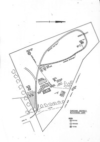
Document - Barry's Reef Scout Camp Documentation
... The Blackwood Scout Camp in Victoria is a scenic bushland site nestled in the Moorabool Shire, near the historic gold-mining town of Blackwood. ...The Blackwood Scout Camp in Victoria is a scenic bushland site nestled in the Moorabool Shire, near the historic gold-mining town of Blackwood. ...The Blackwood Scout Camp in Victoria is a scenic bushland site nestled in the Moorabool Shire, near the historic gold-mining town of Blackwood. It’s a beloved destination for Scouts seeking rugged adventure, pioneering activities, and quiet immersion in nature. It is commonly referred to as the Barrys Reef Scout Camp. It is located at 10 Mechanics Lane, Barrys Reef (Just 5 km from Blackwood and 9 km from Trentham).Sunshine District Blackwood Campbarry's reef, scouting, scouts -
 Sunshine and District Historical Society Incorporated
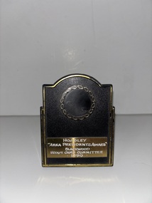
Ephemera - Scouting Hoadley Area Presidents Award Blackwood Scout Camp Committee 1990 Trophy
... The Blackwood Scout Camp in Victoria is a scenic bushland site nestled in the Moorabool Shire, near the historic gold-mining town of Blackwood. ...The Blackwood Scout Camp in Victoria is a scenic bushland site nestled in the Moorabool Shire, near the historic gold-mining town of Blackwood. ...The Blackwood Scout Camp in Victoria is a scenic bushland site nestled in the Moorabool Shire, near the historic gold-mining town of Blackwood. It’s a beloved destination for Scouts seeking rugged adventure, pioneering activities, and quiet immersion in nature. It is commonly referred to as the Barrys Reef Scout Camp. It is located at 10 Mechanics Lane, Barrys Reef (Just 5 km from Blackwood and 9 km from Trentham). Plastic plaqueScouting Hoadley Area Presidents Award Blackwood Scout Camp Committee 1990scouting, scouts -
Bacchus Marsh & District Historical Society
Plaque, Shire of Bacchus Marsh Coat of Arms
... When the Bacchus Marsh Shire amalgamated with other Shires to form Moorabool Shire in 1994 this design was superseded....When the Bacchus Marsh Shire amalgamated with other Shires to form Moorabool Shire in 1994 this design was superseded. ...Coat of Arms used by the Shire of Bacchus Marsh in the 1980s and 1990s. A coat of arms has been in use in the Shire at least from the early 20th century. This earlier coat of arms described in 1910 featured two cows standing on two bales of lucerne hay, with lucerne fields and fruit trees and rolling hills all round a central valley with two rivers running through it. This early coat of arms was superseded by the slightly different design shown here. When this change took place is not known. When the Bacchus Marsh Shire amalgamated with other Shires to form Moorabool Shire in 1994 this design was superseded.The plaque showing the Bacchus Marsh Shire Coat of Arms is in near perfect condition and as such is an excellent example of the physical symbols used to demonstrate the presence of local government in the Bacchus Marsh region. The images on the coat of arms also depict key economic and agricultural activities in the region which provides historical information about the region in a visual and artistic way.Painted cast bronze plaque with inscription on outer white band in black capital lettering: SHIRE OF BACCHUS MARSH. Inner circle painted blue with shield and decorative branches bearing yellow leaves on either side. Shield quartered and surmounted by stylised sunrise. In four quarters, representations of significant local primary and secondary industries. SHIRE OF BACCHUS MARSH.coats of arms, shire of bacchus marsh -
Unions Ballarat
Photograph: Mr Norm Borchers, 1988
... She served as a councillor and mayor at the Moorabool Shire. Norm Borchers passed away in 2008. ...She served as a councillor and mayor at the Moorabool Shire. Norm Borchers passed away in 2008. ...Photograph: Norm Borchers Photo was taken near cannons and memorial stone at Eureka Stockade, Ballarat, on the day on an ALP barbeque (Marg Card campaign). Marg Card unsuccessfully contested the 1998 federal election for the seat of Ballarat. She served as a councillor and mayor at the Moorabool Shire. Norm Borchers passed away in 2008. Borchers was a Club President of the Sebastopol Lions Club (1975-76). He worked for the railways as an engineering employee and was long-term trade unionist (Amalgamated Engineering Union and the Australian Railways Union) and ALP member; he lived and worked in the Ballarat area. Norm was active in workplace disputes during the ALP split in 1955. He was a long time supporter of Ballarat Trades Hall. Photographbtlc, ballarat trades and labour council, ballarat trades hall, borchers, norm, elections, alp, australian labor party, eureka stockade, card, margaret -
 Ballan Shire Historical Society
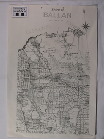
Map - Map. Shire of Ballan, Shire of Ballan
... This is a fairly comprehensive map of the former Shire of Ballan which is now amalgamated into the Shire of Moorabool....Ballan Shire Historical Society 45-47 Steiglitz St Ballan goldfields This is a fairly comprehensive map of the former Shire of Ballan which is now amalgamated into the Shire of Moorabool. gordon ballan bungal kerrit bareet borhoneyghurk bungeeltap ballark yaloak gorong beremboke wallace ingliston hunterston millbrook bradshaw myrniong blackwood moorarbool greendale bayup trentham bullarto korweinguboora glenlyon bolwarra A black and white map of the Shire of Ballan showing major roads, rivers, towns, settlements, State parks and forests and land subdivisions. ...This is a fairly comprehensive map of the former Shire of Ballan which is now amalgamated into the Shire of Moorabool.A black and white map of the Shire of Ballan showing major roads, rivers, towns, settlements, State parks and forests and land subdivisions. It appears to be a copy of the original as no dates or maker or printer appear on the map. There is a scale of 2 miles to 1 inch.gordon, ballan, bungal, kerrit bareet, borhoneyghurk, bungeeltap, ballark, yaloak, gorong, beremboke, wallace, ingliston, hunterston, millbrook, bradshaw, myrniong, blackwood, moorarbool, greendale, bayup, trentham, bullarto, korweinguboora, glenlyon, bolwarra -
Unions Ballarat
Photograph: Kim Beazley, Marg Card, Karen Overington, Dianne Hadden, 6 August 1998
... She served as a councillor and mayor at the Moorabool Shire. Karen Overington was a former welfare worker and served as a councillor and mayor (Sebastopol Borough) before she was elected to federal parliament in 1999. ...She served as a councillor and mayor at the Moorabool Shire. Karen Overington was a former welfare worker and served as a councillor and mayor (Sebastopol Borough) before she was elected to federal parliament in 1999. ...Photograph: Kim Beazley, Marg Card, Karen Overington, Dianne Hadden Kim Beazley is a former diplomat, he was an ALP federal MP, deputy prime minister and leader of the opposition. Beazley was part of the Hawke/Keating cabinet and served in such roles as Minister for Defence and Minister for Finance. Dianne Hadden was an ALP member, but resigned and became an independent. She served in the Victorian Legislative Council from 1999-2006. Ms Hadden stood for the Legislative Assembly seat of Ballarat East in 2007, but was unsuccessful. Marg Card unsuccessfully contested the 1998 federal election for the seat of Ballarat. She served as a councillor and mayor at the Moorabool Shire. Karen Overington was a former welfare worker and served as a councillor and mayor (Sebastopol Borough) before she was elected to federal parliament in 1999. Karen did not contest the 2010 election. She died from cancer in 2011.Photograph.btlc, ballarat trades hall, ballarat trades and labour council, card, marg, overington, karen, elections, hadden, dianne, politicians, cabinet, alp, australian labor party -
Unions Ballarat
Photograph: Marg Card, Dianne Hadden, Karen Overington, Candy Bread, Terry Bracks & Jenny Beacham, 1999
... She served as a councillor and mayor at the Moorabool Shire. Dianne Hadden was an independent member of the Victorian Legislative Council. ...She served as a councillor and mayor at the Moorabool Shire. Dianne Hadden was an independent member of the Victorian Legislative Council. ...Photograph: Marg Card, Dianne Hadden, Karen Overington, Candy Bread, Terry Bracks & Jenny Beacham at a breakfast gathering. Marg Card unsuccessfully contested the 1998 federal election for the seat of Ballarat. She served as a councillor and mayor at the Moorabool Shire. Dianne Hadden was an independent member of the Victorian Legislative Council. She exited the Australian Labor Party in 2005. She stood for the seat of Ballarat East at the Victorian Legislative Assembly in 2006, but was unsuccessful. Karen Overington was a former welfare worker and served as a councillor and mayor (Sebastopol Borough) before she was elected to federal parliament in 1999. Karen did not contest the 2010 election. She died from cancer in 2011. Terry Bracks is the wife of former Victorian Premier, Steve Bracks. She is actively involved in arts and theatre organisations in Victoria and is a board member of Breast Cancer Network Australia, the National Film and Sound Archive, and the Australian Children’s Television Foundation. Jenny Beacham is a former Labor state secretary and was an ALP candidate for Ballarat in 1996. Photographbtlc, ballarat trades hall, ballarat trades and labour council, card, marg, hadden, dianne, overington, karen, bread, candy, bracks, terry, beacham, jenny, alp, australian labor party -
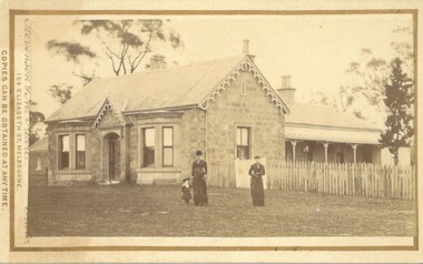 Bacchus Marsh & District Historical Society
Photograph, Stone Villa house 4 Bennett Street Bacchus Marsh 1883
... As of April 2024 it remains as a private residence and is listed as a heritage property in the Moorabool Shire planning scheme. The identity of the two women and young girl in the foreground of the image has not been established. ...As of April 2024 it remains as a private residence and is listed as a heritage property in the Moorabool Shire planning scheme. The identity of the two women and young girl in the foreground of the image has not been established. ...The house depicted in this image was constructed in 1865 for James Young a prominent local businessman and participant in community affairs. James Young left Bacchus Marsh in 1869. In 1870 Stone Villa was purchased by local solicitor Francis Gell. In 1872 it was bought by William Collyer. For a time before 1883 it was used as a school operated by Mr Thomas Kissock and his wife. From 1883 until 1922 it was used as a parsonage by the Church of England. In 1922 it was sold to Frederick Slack as a private residence. Since Slack's ownership there have been other owners. As of April 2024 it remains as a private residence and is listed as a heritage property in the Moorabool Shire planning scheme. The identity of the two women and young girl in the foreground of the image has not been established. One of the women, and the child are possibly the wife and daughter of the Rev A.C. McCausland who was the Church of England Vicar in Bacchus Marsh from 1872 until 1885 and would have resided in this house in 1883 when this picture was produced.An early visual record of one of the most culturally and architecturally significant nineteenth century stone houses in Bacchus Marsh.Small sepia 'carte de visite' style unframed photograph on card with gold border framing photograph. Housed in the album, 'Photographs of Bacchus Marsh and District in 1883 by Stevenson and McNicoll', the Jeremeas Family Album. The photo is of a stone dwelling with an ornate gable above the inset front door which is flanked by two double windows, one of which is a bay window. The gable roof line bears ornate woodwork. A weatherboard extension with verandah has been added to the rear of the house, running north-south. A picket fence lines the block to the side of the dwelling. Two elegantly dressed women, both holding a furled umbrella, stand at the front, one holding the hand of a little girl.Printed On the front: Stevenson & McNicoll. Photo. 108 Elizabeth St. Melbourne. COPIES CAN BE OBTAINED AT ANY TIME. On the back: LIGHT & TRUTH inscribed on a banner surmounted by a representation of the rising sun. Copies of this Portrait can be had at any time by sending the Name and Post Office Money Order or Stamps for the amount of order to STEVENSON & McNICOLL LATE BENSON & STEVENSON, Photographers. 108 Elizabeth Street, MELBOURNE. Hand written on the reverse: 'Stone Villa built by James Young 1860 (sic) as his private residence, later as a school (Mr and Mrs Kissock proprietors) bought by CofE for Vicarage 1883-1922. Courtesy of Mrs J Jeremeas, Photo 1883' james young 1816-1871, houses, stone villa bacchus marsh, clergy residences, bacchus marsh vic. history, schools bacchus marsh, stevenson and mcnicoll 1883 photographs of bacchus marsh and district -
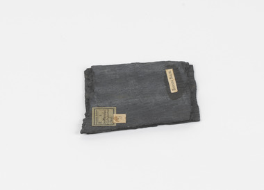 The Beechworth Burke Museum
Geological specimen - Slate (Metamorphic), Unknown
... Many of these specimens were sent to research and collecting organisations across Australia, including the Burke Museum, to educate and encourage further study. burke museum beechworth geological slate metamorphic slate (metamorphic) geological specimen slate specimen indigo shire Geological survey / R S / Loc Moorabool /Slate quarries / 1/4 sheet | 78 | Roofing Slate / A somewhat rectangular foliated metamorphic rock composed of quartz, sericite and minerals from the chlorite group that make up the compounds of slate. ...This particular specimen was found in the Moorabool Slate quarries in Victoria. The Moorabool Slate quarries was established in the 1860’s by a company of Welshmen with a crew of six who purchased land by the riverside to mine for slate. Under the promise of adding to existing recourses the crew mined the slate which was used for paving and roofing. Slate is a fine-grained, low-grade metamorphic rock that is formed by the transformation of mudstone, shale or sometimes volcanic ash under low pressure and temperatures. It dark colour is due to carbonaceous material or to finely divided iron sulphide. It is believed that Evan Rowlands and Theophilus Williams of Ballarat were the first to discover the slate veins. Slate is a one of the most common natural stones in general use. Being used as paving, flooring, roofing and more. However, its history of being mined in Australia is not common as it is considered that the best places to mine slate is Spain and parts of the United Kingdom. This specimen is part of a larger collection of geological and mineral specimens collected from around Australia (and some parts of the world) and donated to the Burke Museum between 1868-1880. A large percentage of these specimens were collected in Victoria as part of the Geological Survey of Victoria that begun in 1852 (in response to the Gold Rush) to study and map the geology of Victoria. Collecting geological specimens was an important part of mapping and understanding the scientific makeup of the earth. Many of these specimens were sent to research and collecting organisations across Australia, including the Burke Museum, to educate and encourage further study.A somewhat rectangular foliated metamorphic rock composed of quartz, sericite and minerals from the chlorite group that make up the compounds of slate. The rock is dark grey almost black.Geological survey / R S / Loc Moorabool /Slate quarries / 1/4 sheet | 78 | Roofing Slate /burke museum, beechworth, geological, slate, metamorphic, slate (metamorphic), geological specimen, slate specimen, indigo shire -
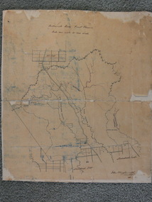 Ballan Shire Historical Society
Map - Map. Bullarook State Forest, Bullarook State Forest Reserve
... Ballan Shire Historical Society 45-47 Steiglitz St Ballan goldfields moorabool west state forest bullarook eastern moorabool river werribee river moorabool east blakes saw mill wombat andersons saw mill A small map of the Bullarook State Forest Reserve. ...A small map of the Bullarook State Forest Reserve. Drawn on a fine buff coloured paper attached to a stiff cloth backing sheet. The title is hand written and includes a "scale one mile to one inch" hand written also. The map is signed "John Wrigglesworth, assistant ? and dated 26/6/1869" although the month and year are almost illegible.moorabool west, state forest, bullarook, eastern moorabool river, werribee river, moorabool east, blakes saw mill, wombat, andersons saw mill -
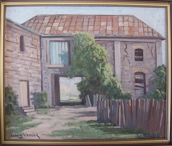 Glenelg Shire Council Cultural Collection
Painting, Travis Webber, Greenmount from the rear, c. 1955
... Shire Council Cultural Collection History House Cliff Street Portland great-ocean-road Travis Webber was born in South Australia in 1900. He died in 1968. He studied at the South Australian School of Arts where he went on to teach. Webber established himself as one of the Australia's most prolific landscape artists. His work is held in several large galleries. oil painting Greenmount Landscape Portland Landscape Front: Travis Webber (brown paint, lower left) Back: Geelong Picture Framers, 211 Moorabool ...Travis Webber was born in South Australia in 1900. He died in 1968. He studied at the South Australian School of Arts where he went on to teach. Webber established himself as one of the Australia's most prolific landscape artists. His work is held in several large galleries.Bluestone building with a shingle roof. In foreground right is a wooden fence. A carriageway cuts through centre of building, and above this is a window filled in with corrugated iron. The right side of building has large cracks. A tree is growing against the building in image centre, and bushes at image left and right. Framed in wooden frame.Front: Travis Webber (brown paint, lower left) Back: Geelong Picture Framers, 211 Moorabool Street, Gelong. Ph: 97805 (blue ink stamp, lower centre).oil painting, greenmount, landscape, portland landscape -
 Glenelg Shire Council Cultural Collection
Painting, Travis Webber, Town Hall, Portland, 1955
... Glenelg Shire Council Cultural Collection History House Cliff Street Portland great-ocean-road Portland Town Council Portland Town Hall bluestone building Bluestone 1800s Front: Town Hall Portland '55 (brown paint, lower let). Travis Webber (brown paint, lower right). Back: Geelong Picture Framers, 211 Moorabool ...Portland Town CouncilPainting of a bluestone building. There are four columns to the front of the building. One either side of a green front door and the other two either side of each side window. Above the front door is a sign which reads ' Town Hall 1869' A footpath is in front of the building, with a man and woman walking together. The man wears a suit and hat and the woman wears a red shirt and blue skirt. At the other side of the building there is another figure - shadowy. A dirt road curves from foreground centre towards and past the building to the left. Two tall pines are behind the building on right.Front: Town Hall Portland '55 (brown paint, lower let). Travis Webber (brown paint, lower right). Back: Geelong Picture Framers, 211 Moorabool Street, GEELONG. Ph. 97805 (blue ink stamp, lower centre).portland town hall, bluestone building, bluestone, 1800s -
National Wool Museum
Book, Eliza Forlonge: her life, her family, her vision
... National Wool Museum 26 Moorabool Street Geelong geelong-and-the-bellarine-peninsula "Eliza Forlonge: her life, her family, her vision" - Sally Wilde, Shire of Euroa, 1994. ..."Eliza Forlonge: her life, her family, her vision" - Sally Wilde, Shire of Euroa, 1994. Short biography of Eliza Forlonge whose family operated the Seven Creeks Station at Euroa, using Saxon Merinos purchased by her.sheep stations - history sheep breeding - history merino sheep - history, forlonge, mrs eliza, seven creeks station, euroa, sheep stations - history, sheep breeding - history, merino sheep - history