Showing 16 items matching "mordialloc railway line"
-
 City of Kingston
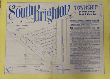
Pamphlet - Colour, Brock Bros, South Brighton Township Estate, 1888
... Sales plan for land in the suburb of South Brighton (Moorabbin), bounded by Point Nepean Road, South Road, Patterson Street and the Mordialloc Railway Line. Incorporates Wolsely Street and Gordon Street...Incorporates a map of the estate bordered by Point Nepean Road, South Road, Patterson Street, and the Mordialloc Railway Line. Includes Wolsley Street and Gordon Street. ...Incorporates a map of the estate bordered by Point Nepean Road, South Road, Patterson Street, and the Mordialloc Railway Line. Includes Wolsley Street and Gordon Street. ...Sales plan for land in the suburb of South Brighton (Moorabbin), bounded by Point Nepean Road, South Road, Patterson Street and the Mordialloc Railway Line. Incorporates Wolsely Street and Gordon StreetThe developing urban area of Moorabbin within the City of Kingston. This land sale pamphlet illustrates the subdivision of land within the municipality and the changing demographic of the district as new houses are constructed close to infrastructure.Colour pamphlet advertising for private sale the South Brighton Township Estate, South Brighton. Incorporates a map of the estate bordered by Point Nepean Road, South Road, Patterson Street, and the Mordialloc Railway Line. Includes Wolsley Street and Gordon Street. land sales, south brighton, estate, moorabbin -
 City of Moorabbin Historical Society (Operating the Box Cottage Museum)
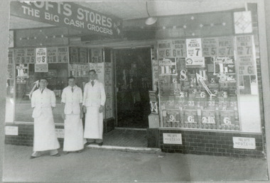
Photograph - Black & White, Crofts Grocery 395 Centre Rd Bentleigh c1937, c1937
... ...mordialloc railway line...After the extension of the Railway line from Caulfield to Mordialloc 1880's the shopping centre moved from the Tucker Rd end to around the East Brighton (Bentleigh) Station area of Centre Road. ...Crofts Grocery Store was one of the shops in the Centre Road Bentleigh shopping strip that were established after the arrival of the train line 1881 crofts grocery store bentleigh lees jack mordialloc railway line centre road bentleigh smith j l smith mary ann stanley helen smith vic smith harry redvers chaff cutter horse drawn carts toll gates brighton motor cars 1900 steam engines early settlers bentleigh parish of moorabbin city of moorabbin county of bourke moorabbin roads board shire of moorabbin henry dendy's special survey 1841 were j.b. bent thomas o'shannassy john king richard charman stephen highett william ormond francis maynard dennis market gardeners vineyards Handwritten information Black & White photograph of 3 men outside Crofts Grocery Store 395 Centre Rd Bentleigh c 1937 Mr Jack Lees is centre. ...After the extension of the Railway line from Caulfield to Mordialloc 1880's the shopping centre moved from the Tucker Rd end to around the East Brighton (Bentleigh) Station area of Centre Road. A variety of shops, forges, estate agents, Coles' and Fossey's variety stores, a Hoyts picture theatre, butchers, traded in Centre Rd. Crofts was one many grocery stores along the strip. Crofts Stores was established by Archibald Crofts (1875-1942) as a single grocery store in South Melbourne. It eventually expanded to include 137 branches throughout Victoria, trading as Crofts Stores. The Lees family had established a Seedling Nursery in Thomas St that has continued until the land sold 2018 for housing development.Crofts Grocery Store was one of the shops in the Centre Road Bentleigh shopping strip that were established after the arrival of the train line 1881Black & White photograph of 3 men outside Crofts Grocery Store 395 Centre Rd Bentleigh c 1937 Mr Jack Lees is centre.Handwritten informationcrofts grocery store bentleigh, lees jack, mordialloc railway line, centre road bentleigh, smith j l, smith mary ann, stanley helen, smith vic, smith harry redvers, chaff cutter, horse drawn carts, toll gates brighton, motor cars 1900, steam engines, early settlers, bentleigh, parish of moorabbin, city of moorabbin, county of bourke, moorabbin roads board, shire of moorabbin, henry dendy's special survey 1841, were j.b., bent thomas, o'shannassy john, king richard, charman stephen, highett william, ormond francis, maynard dennis, market gardeners, vineyards -
 Glen Eira Historical Society
Article - VICTORIAN RAILWAYS
... Article reports that a special train will run from Spencer Street Station to Mordialloc railway Station on Saturday 19/12/1981 to celebrate the centenary of the railway line to Mordialloc. ...Article reports that a special train will run from Spencer Street Station to Mordialloc railway Station on Saturday 19/12/1981 to celebrate the centenary of the railway line to Mordialloc. ...File contains 3 items: 1/Original handwritten notes by Leo J Harrington (VR Melbourne) and T O’Callaghan titled ‘Victorian Railways to ‘62’. Notes include dates of electrification of lines, station openings, valuations, railway station names and their origins. Reference to council minutes regarding request to change the name of Elsternwick station to Caulfield in June 1871. 2/Original newspaper article from ‘The Age’ dated 10/06/1978 by Graeme Davidson titled ‘A case study of Railway politics’. Article refers to a publication called ‘Return to Rosstown, Railway, Land Sales and Sugar Beet ventures in Caulfield’ by D. F. ‘Return to Rosstown’ recounts the story of the Rosstown Junction railway and its creator, William Murray Ross. Tells of Ross’ life since coming to Australia from Liverpool and how he prospered as a land speculator owning large tracts of land in Caulfield, the sugar mill and his plans to operate a railway. 3/Original newspaper article (and image) from ‘Moorabbin Standard’ dated 25/11/1981, titled ‘Centenary train to carry mayors’. Article reports that a special train will run from Spencer Street Station to Mordialloc railway Station on Saturday 19/12/1981 to celebrate the centenary of the railway line to Mordialloc. Story mentions that in 1881, the Caulfield to Mordialloc line was a single track and that passengers can also board the special train at Caulfield Station. Image is of steam train with red ‘tait’ carriages (undated).victorian railways, caulfield, glenhuntly, glen huntly, elsternwick, carnegie, murrumbeena, ormond, steam train, glenhuntly road, glen huntly road, ripponlea, north road, rosstown, rosstown junction railway, ross william murray, railways, trains, south caulfield, grange road, railway stations, mirrambeena, caulfield city council, sugar mill, electrification. -
 Eltham District Historical Society Inc
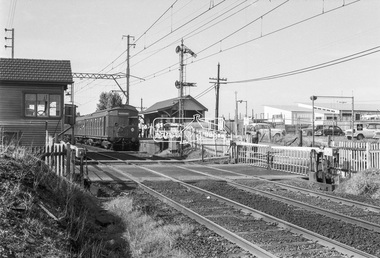
Photograph, George Coop, Tait (Red Rattler) train bound for Mordialloc at McKinnon Railway Station, c.Feb. 1964
... line...George Coop Collection...Level Crossing...Mckinnon Railway Station...Mckinnon Road...Mordialloc...Tait (Red Rattler) train bound for Mordialloc at McKinnon Road level crossing, McKinnon Railway Station, Frankston line, c. ...Eltham District Historical Society Inc 728 Main Rd Eltham melbourne Tait (Red Rattler) train bound for Mordialloc at McKinnon Road level crossing, McKinnon Railway Station, Frankston line, c. ...Tait (Red Rattler) train bound for Mordialloc at McKinnon Road level crossing, McKinnon Railway Station, Frankston line, c. Feb. 1964 The level crossing is the old McKinnon Rd. level crossing right at Mckinnon Railway Station on the Melbourne-Franston line. It no longer exists as the level crossing was amongst the first to be removed in the State Govt. grade separation programme c 2015. The line now runs under Mckinnon Rd in a cutting that holds the new station as well. The folding metal lattice gates were the only ones of their kind in Victoria and fairly rare anywhere else in Australia as well.Digital TIFF file Scan of 35mm Ilford FP3 black and white transparencyfrankston line, george coop collection, level crossing, mckinnon railway station, mckinnon road, mordialloc, red rattler, tait train -
 Eltham District Historical Society Inc
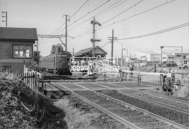
Photograph, Tait (Red Rattler) train bound for Mordialloc at McKinnon Road level crossing, Mckinnon Railway Station, Frankston line, c.1970, 1970
... Tait (Red Rattler) train bound for Mordialloc at McKinnon Road level crossing, Mckinnon Railway Station, Frankston line, c.1970...frankston line, mordialloc, red rattler, tait train, Mckinnon Road, Level crossing, Mckinnon Railway Station...Railway Station on the Melbourne-Franston line. It no longer exists as the level crossing was amongst the first to be removed in the State Govt. grade separation programme c 2015. The line now runs under Mckinnon Rd in a cutting that holds the new station as well. The folding metal lattice gates were the only ones of their kind in Victoria and fairly rare anywhere else in Australia as well. frankston line, mordialloc ...The level crossing is the old McKinnon Rd. level crossing right at Mckinnon Railway Station on the Melbourne-Franston line. It no longer exists as the level crossing was amongst the first to be removed in the State Govt. grade separation programme c 2015. The line now runs under Mckinnon Rd in a cutting that holds the new station as well. The folding metal lattice gates were the only ones of their kind in Victoria and fairly rare anywhere else in Australia as well. Digital TIFF file Scan of 9 x 13 cm black and white printfrankston line, mordialloc, red rattler, tait train, mckinnon road, level crossing, mckinnon railway station -
 City of Moorabbin Historical Society (Operating the Box Cottage Museum)
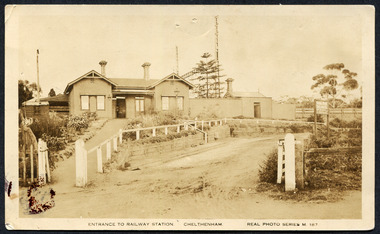
Photograph, Black & White Postcard, Cheltenham Railway Station c1920, c1920
... The arrival of the Railway Line saw the traders move from Point Nepean Rd to Charman Rd and by 1910 various shops and business were present. 2016 - current has seen large protest rallies against the destruction of Mentone Station and Cheltenham Station as the Victorian State Government proceeds to remove Railway Level Crossings. A compromise to retain the Station buildings whilst placing the Rail Line underground is desired. Cheltenham Railway Station is one of the original cottage style stations ordered by Sir Thomas Bent when the rail line was extended from Caulfield to Mordialloc ...Although the Railway line had been planned for some time Sir Thomas Bent MP was responsible for making it happen in order to revitalize the fortunes of the Moorabbin Shire that he had represented for so long. The train line opened in 1881with 8 Stations between Caulfield and Mordialloc.The first Steam engine carried dignitaries and local residents. Bent also ensured that the Station houses in his constituency were built in a distinctive decorative cottage style. Bent faced severe criticism for diverting the rail line through his local area and for the expenditure on the Stations. Local residents established and cared for Gardens at the Stations and Cheltenham was awarded Best Garden c1910. The arrival of the Railway Line saw the traders move from Point Nepean Rd to Charman Rd and by 1910 various shops and business were present. 2016 - current has seen large protest rallies against the destruction of Mentone Station and Cheltenham Station as the Victorian State Government proceeds to remove Railway Level Crossings. A compromise to retain the Station buildings whilst placing the Rail Line underground is desired.Cheltenham Railway Station is one of the original cottage style stations ordered by Sir Thomas Bent when the rail line was extended from Caulfield to Mordialloc 1881Photograph Black & White Postcard showing the entrance to Cheltenham Railway Station c1920Valentine &Sons Pub Co Ltd Melb railways, cheltenham station, mentone station, south brighton station, railway level crossing removal 2016 -19, smith j l; smith mary ann, stanley helen, smith vic, smith harry redvers, chaff cutter, horse drawn carts, toll gates brighton, motor cars 1900, steam engines, early settlers, bentleigh, parish of moorabbin, city of moorabbin, county of bourke, moorabbin roads board, shire of moorabbin, henry dendy's special survey 1841, were j.b.; bent thomas, o'shannassy john, king richard, charman s, highett william, ormond francis, maynard dennis, market gardeners, vineyards, orchards -
 City of Moorabbin Historical Society (Operating the Box Cottage Museum)
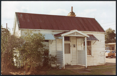
Photographs,x3 Colour Early Weatherboard Cottage Cheltenham c1880, 1981
... Notable settlers who moved into the area were Keys, Charman, Bruton, Le Page, Fairlam, Meeres and 1862 saw the separation from Brighton and the formation of the Mooorabbin Roads Board District. .By 1879 1000settlers were living in 'Cheltenham' serviced by a Post Office with Bank, Mechanics Institute, State School No 84,Keys Hotel, Meeres Store, Sir Thomas Bent ensured the new Railway Line from Caulfield to Mordialloc went through his constituency of Cheltenham 1881 and this changed the development to the bayside area of Cheltenham away from the 'Two Acre Village ' side causing some dissention, However Cheltenham as whole prospered and this house in Pine St is typical of the cottages built c 1890- 1900 in the area. ...Notable settlers who moved into the area were Keys, Charman, Bruton, Le Page, Fairlam, Meeres and 1862 saw the separation from Brighton and the formation of the Mooorabbin Roads Board District. .By 1879 1000settlers were living in 'Cheltenham' serviced by a Post Office with Bank, Mechanics Institute, State School No 84,Keys Hotel, Meeres Store, Sir Thomas Bent ensured the new Railway Line from Caulfield to Mordialloc went through his constituency of Cheltenham 1881 and this changed the development to the bayside area of Cheltenham away from the 'Two Acre Village ' side causing some dissention, However Cheltenham as whole prospered and this house in Pine St is typical of the cottages built c 1890- 1900 in the area. ...Henry Dendy , a farmer from Sussex England, purchased 5,120 acres of land in the area of a 'Special Survey 1841' that extended from Brighton bayside North Road, East Boundary Rd to South Road. This area became known as Dendy's Brighton and as part of the sale 139 emigrant workers arrived in 1842 however Dendy was unable to find work and lodgings for these people. J.B.Were, financier took over the management of the 'Special Survey 1841' area and began to sell and lease allotments. 1850 the Squatter King brothers sold land south of Dendy's 'Special Survey 1841' to Josiah Holloway who sectioned it into 2 acre lots @ £10 each for market gardens - 'Two Acre Village' and Charles Whorral opened a small hotel - 'The Cheltenham Inn' on the main Road - Arthur's Seat Rd, later Point Nepean Rd, now Nepean Highway. Notable settlers who moved into the area were Keys, Charman, Bruton, Le Page, Fairlam, Meeres and 1862 saw the separation from Brighton and the formation of the Mooorabbin Roads Board District. .By 1879 1000settlers were living in 'Cheltenham' serviced by a Post Office with Bank, Mechanics Institute, State School No 84,Keys Hotel, Meeres Store, Sir Thomas Bent ensured the new Railway Line from Caulfield to Mordialloc went through his constituency of Cheltenham 1881 and this changed the development to the bayside area of Cheltenham away from the 'Two Acre Village ' side causing some dissention, However Cheltenham as whole prospered and this house in Pine St is typical of the cottages built c 1890- 1900 in the area. This weatherboard house c 1890-1900 in Pine St Cheltenham is typical of those built for early settler families. Photo taken 1981 by CMHS member 3 x Colour photographs of an early c 1900 weatherboard house in Pine St Cheltenham taken by CMHS member 1981Kodak Aug. 81 / Handwritten Pine St Cheltenhamkeys robert, holloway josiah, king brothers, smith j l; smith mary ann, stanley helen, chaff cutter, horse drawn carts, toll gates brighton, motor cars 1900, steam engines, early settlers, bentleigh, parish of moorabbin, city of moorabbin, county of bourke, moorabbin roads board, shire of moorabbin, henry dendy's special survey 1841, were j.b.; bent thomas, o'shannassy john, king richard, charman stephen, highett william, ormond francis, maynard dennis, market gardeners, vineyards, orchards -
 City of Moorabbin Historical Society (Operating the Box Cottage Museum)
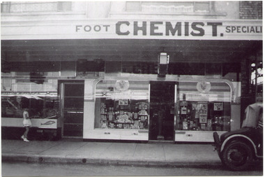
Photograph, Black & White, Mr Moore's 1st Chemist Shop Centre Road, Bentleigh c1930, c1930
... ...railway line caulfield -mordialloc 1881...Following the opening of the Railway line from Caulfield to Mordialloc 1881 the shops and business moved from the Tucker Road /Centre Road ( East Brighton ) East Bentleigh area to be close to the transport. ...Following the opening of the Railway line from Caulfield to Mordialloc 1881 the shops and business moved from the Tucker Road /Centre Road East Bentleigh area to be close to the transport. ...Early settlers in the Parish of Moorabbin, County of Bourke, established market gardens and farms in the area of Henry Dendy's Special Survey 1841 Brighton. Small communities grew near Churches & Schools and shops and businesses were established. Following the opening of the Railway line from Caulfield to Mordialloc 1881 the shops and business moved from the Tucker Road /Centre Road ( East Brighton ) East Bentleigh area to be close to the transport. Shops, businesses and housing developed along Centre Road between Thomas Street and Jasper Road. Mr Arthur Moore established his 1st shop in 395 Centre Road c1930 and later moved along the road to a site next to Coles Variety Store.Following the opening of the Railway line from Caulfield to Mordialloc 1881 the shops and business moved from the Tucker Road /Centre Road East Bentleigh area to be close to the transport. Shops, businesses and housing developed along Centre Road between Thomas Street and Jasper Road. Mr Moore established his 1st shop in 395 Centre Road c1930 and later moved along the road to a site next to Coles Variety Store.Black & White photograph of Mr Arthur Moore's 1st Chemist Shop, 384 Centre Road Bentleigh c 1930 back Handwritten information unsignedbentleigh shopping centre c1930, east brighton, railway line caulfield -mordialloc 1881, chemists, pharmacy, moore's moorabbin shire, smith j l, smith mary ann, stanley helen, smith vic, smith harry redvers, chaff cutter, horse drawn carts, toll gates brighton, motor cars 1900, steam engines, early settlers, bentleigh, mckinnon, parish of moorabbin, city of moorabbin, county of bourke, moorabbin roads board, shire of moorabbin, henry dendy's special survey 1841, were j.b., bent thomas, o'shannassy john, king richard, charman stephen, highett william, ormond francis, maynard dennis, market gardeners, vineyards, orchards -
 City of Moorabbin Historical Society (Operating the Box Cottage Museum)
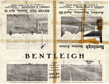
Flyer - Bentleigh Station Estate Auction, Coghill & Haughton - W.H. Wood, Bentleigh, c1914
... line to Mordialloc was built. The land boom came to a halt in the 1890's due to the depression. This sale was also successful as the electrification of the train line from the city to Frankston had been announced. Example of the progress of the Municipality of Moorabbin. Centre Road Mavho Street Loranne Street Burgess Street Bentleigh Bentleigh Railway ...One of the first sales in the district since the land boom which began in 1881when the train line to Mordialloc was built. The land boom came to a halt in the 1890's due to the depression. This sale was also successful as the electrification of the train line from the city to Frankston had been announced.Example of the progress of the Municipality of Moorabbin.Advertising flyer for auction of real estate sales - plan of building blocks for sale - pictures of local area50 Choice Building Blocks adjoining Bentleigh Railway Stationcentre road, mavho street, loranne street, burgess street, bentleigh, bentleigh railway station, real estate, auctions -
 City of Kingston
Photograph - Black and white, c. 1970
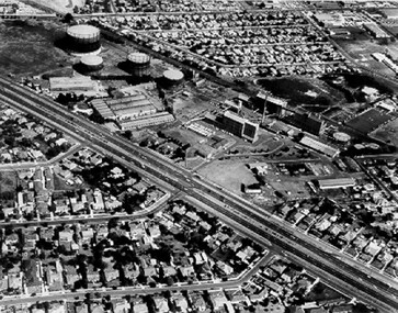
... railway line. The first gasholder was erected on the Highett site in 1927 and connected with high pressure mains to the Brighton Gas Works. In 1939 the building program including gasometers, the vertical retort house and coal store was completed and gas making commenced. Its area of supply covered approximately 70 square miles and included the municipalities of Brighton, Sandringham, Moorabbin, Mordialloc ...The Highett Gas Works were a landmark along the Nepean Highway for many years. With the cessation of the gasification of coal and the introduction of natural gas to Victoria, the gas holders were demolished and the Sir William Fry Reserve was developed on the southern end of the site. The Gas and Fuel redeveloped the northern end of the site with modern offices and laboratories for the organisation's scientific services. At this time, the chimney and retort house were retained.The Highett Gasworks had its beginning in 1939 operated by the Central Brighton and Moorabbin Gas Co Ltd. The company had expanded its gas production facilities to Highett where it had purchased 45 acres of land adjacent to the Melbourne-Frankston railway line. The first gasholder was erected on the Highett site in 1927 and connected with high pressure mains to the Brighton Gas Works. In 1939 the building program including gasometers, the vertical retort house and coal store was completed and gas making commenced. Its area of supply covered approximately 70 square miles and included the municipalities of Brighton, Sandringham, Moorabbin, Mordialloc, Chelsea and part of Dandenong. The Gas and Fuel Corporation eventually took over operations and with the disaggregation and privatisation of the organisation, the site was eventually closed c. 2002.Black and white aerial photograph featuring the Highett Gas Works with gasholders and retort house. In the top right-hand corner, a former Highett Primary School on Graham Road can be viewed. Photograph includes Bay Road, Royal Avenue, Princess Avenue and Jackson Road (Highett) and Alfred, Turner and Sandford Streets (Moorabbin).Handwritten in black ink: [indecipherable] in a circle Handwritten in red ink: 70% Four velcro display adhesivesgasification of coal, gas and fuel corporation of victoria, gasholders, highett, moorabbin, utilities -
 City of Kingston
Photograph - Black and white, c. 1958
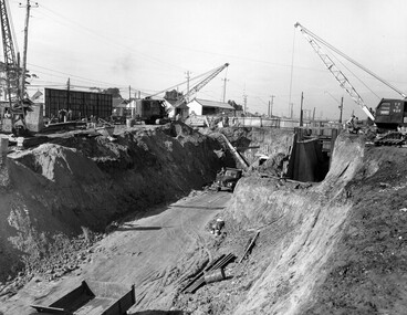
... line was extended from Mordialloc. Moorabbin station opened in 1881 and was originally called South Brighton station. It was renamed Moorabbin station in 1907. In 1958 the station was relocated below street level which coincided with other construction works on Nepean Highway and South Road. This image is part of a larger collection of images from the Public Transport Corporation displaying train stations and streetscapes in what is now the City of Kingston. Moorabbin Railway ...Moorabbin station sits on the Frankston line which first opened in 1882 when the line was extended from Mordialloc. Moorabbin station opened in 1881 and was originally called South Brighton station. It was renamed Moorabbin station in 1907. In 1958 the station was relocated below street level which coincided with other construction works on Nepean Highway and South Road. This image is part of a larger collection of images from the Public Transport Corporation displaying train stations and streetscapes in what is now the City of Kingston.Black and white photograph showing excavations for Moorabbin station to be moved below street level. Stamped in blue ink on reverse: COPYRIGHT / Public Transport Corporation / For re-ordering photographs / Please quote negative No M6004 / Enquiries C/- PTC Photographic Unit / Telephone switchboard 619 111moorabbin, railway station, construction works, suburbs, nepean highway -
 City of Kingston
Photograph - Black and white, Percy Fairlam, c. 1920
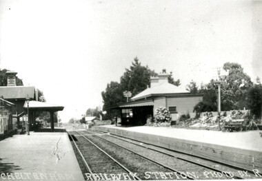
... A survey undertaken by J P Madden, an engineer employed by the railways, established the route, although this was later modified. At the time of the official opening of the line to Mordialloc no station buildings had been constructed despite the fact that tenders had been called in the Government Gazette of 26 May 1881 and subsequently in the Argus newspaper on 30 August 1881 for what became stations at Glenhuntly, Ormond, Bentleigh, Moorabbin, Highett, Cheltenham, Mentone and Mordialloc. ...Cheltenham station was built in 1898 and serviced a primarily rural, market gardening community.The late 1870s saw the beginning of a massive program to construct railway lines throughout Victoria. One of these lines was from Caulfield to Frankston. A survey undertaken by J P Madden, an engineer employed by the railways, established the route, although this was later modified. At the time of the official opening of the line to Mordialloc no station buildings had been constructed despite the fact that tenders had been called in the Government Gazette of 26 May 1881 and subsequently in the Argus newspaper on 30 August 1881 for what became stations at Glenhuntly, Ormond, Bentleigh, Moorabbin, Highett, Cheltenham, Mentone and Mordialloc. However platforms and sidings were completed, ready to receive passengers. Cheltenham station opened in 1898.Black and white photograph of Cheltenham Railway Station with the two platforms separated by two sets of tracks. Each platform has a station house on it, and the one on the right hand side also has a garden and park bench.Handwritten in red ink on reverse: A7 / 75%cheltenham, trains, railway, railway station, railway crossing, suburbs -
City of Kingston
Photograph - Colour, 1993
... The Carrum Station was opened in 1882, when the railway line from Mordialloc was extended to Frankston. ...The Carrum Station was opened in 1882, when the railway line from Mordialloc was extended to Frankston. ...Carrum is a suburb in the City of Kingston bordered by the Patterson River in the north and Kananook Creek in the south. To the east the suburb is adjacent to Patterson Lakes. The Carrum Station was opened in 1882, when the railway line from Mordialloc was extended to Frankston. In the early 20th century, it was a destination for holidaymakers occupying tents and cabins. The area now consists of older housing and over time there have been many new housing developments.Carrum is located in the area that was originally part of the Carrum Carrum Swamp. The district had originally been the home of the Bunerong people who fished, gathered food and found refuge in the sand dunes. The Swamp was drained in 1879 when the Patterson Cut was formed and became known as Patterson River. Apart from local farmers, fishermen and hotel-keepers, there were few permanent residents until the early 20th century when it had become popular as a beach resort. In the 1920s and 1930s the area became occupied by more permanent residents.Laminated aerial colour photograph of Carrum and Patterson Lakes in the City of Kingston. The photograph also includes Kananook Creek and the northern section of Seaford. Prominent features include Roy Dore Reserve, Carrum Primary School, Patterson River Secondary College, Keast Park Seaford, the Seaford Swamp Drain and a section of Downs Estate situated on the traditional lands of the Bunurong people.Black type on white adhesive sticker: No. 7140 Black type of white adhesive sticker: 31-1-93 Black handwritten ink (marker): * [an asterisk] Yellow circular adhesive stickerpatterson lakes, seaford, carrum carrum swamp -
 City of Kingston
Photograph - Digital image, Black and white, c. 1910
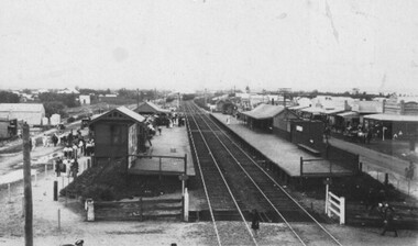
... The extension of the railway line from Mordialloc to Frankston influenced the development of the villages along the train line. ...Black and white image of Chelsea Railway Station showing the impact of the railways on the development of the area. Shops and shoppers can be seen behind the station buildings.The extension of the railway line from Mordialloc to Frankston influenced the development of the villages along the train line. Shops and community buildings were built in proximity to the station, along with the subdivision of land for houses. Black and white image of Chelsea Railway Station showing platforms and local shopschelsea, railway station, railway, shopping strip, public transport -
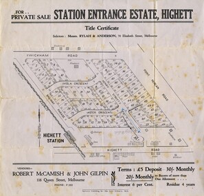 City of Kingston
Pamphlet - Black and white, Robert McCamish & John Gilpin (Vendors), For Private Sale Station Entrance Estate, Highett, 1930s
... The extension of the railway line from the city to Mordialloc opened up the land for development. ...Sales plan for land in the suburb of Highett, bounded by Wickham Road, Railway Parade, Highett Road and Point Nepean Street. The developing urban area of Highett within the City of Kingston. This land sale pamphlet illustrates the subdivision of land within the municipality and the changing demographic of the district as new houses are constructed. The extension of the railway line from the city to Mordialloc opened up the land for development.Black and white pamphlet advertising for private sale the Station Entrance Estate, Highett. Incorporates a map of the estate bordered by Wickham Road, Railway Parade, Highett Road and Point Nepean Road. Handwritten in black ink on reverse: Station Entrance / Estate / Late [indecipherable]highett, land sales, estate -
 Melbourne Tram Museum
Map - Public Transport - St Kilda - Brighton - Sandringham area, David Frost, 1997
... Map prepared by David Frost for a Sandringham & District Historical Society" newsletter during mid 1997, showing tram and bus routes for the VR trams and bus replacement services, railway lines, major roads and proposed horse tram line to Mordialloc. Includes a sketch of tram 22 and a note about the background to the map. ...Melbourne Tram Museum 8 Wallen Road Hawthorn melbourne Map prepared by David Frost for a Sandringham & District Historical Society" newsletter during mid 1997, showing tram and bus routes for the VR trams and bus replacement services, railway lines, major roads and proposed horse tram line to Mordialloc. Includes a sketch of tram 22 and a note about the background to the map. ...Map prepared by David Frost for a Sandringham & District Historical Society" newsletter during mid 1997, showing tram and bus routes for the VR trams and bus replacement services, railway lines, major roads and proposed horse tram line to Mordialloc. Includes a sketch of tram 22 and a note about the background to the map. Notes that the bus routes are to be privatised during Sept. 1997.Yields information about the public transport services and their route history in the St Kilda to Brighton - Sandringham - Black Rock & Southland area.Page prepared for a "Sandringham & District Historical Society newsletter.tramways, trams, sandringham, buses, horse tram, vr trams