Showing 119 items matching mound
-
 Tatura Irrigation & Wartime Camps Museum
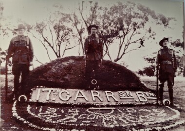
Photograph, Camp 2 opening ceremony
3 of the guards at the opening ceremony for Camp 2.Black and white photograph of 3 guards standing at ease, with a mound behind the centre man and trees in back ground. Foreground shows a sign "17th Garrison Battalion". In stones in front of that is some words and dates.camp 2 rushworth, rushworth camp, camp opening ceremony, garrison guards, 17th battalion, norm whitford -
 Ringwood and District Historical Society
Photograph, Ringwood Rifle Range after the bushfires of January 1962
Black and white photographWritten on back of photograph- "Ringwood Rifle Range after the bushfires of January 1962. Scene looking towards the hut at 300 yard mound." -
 Churchill Island Heritage Farm
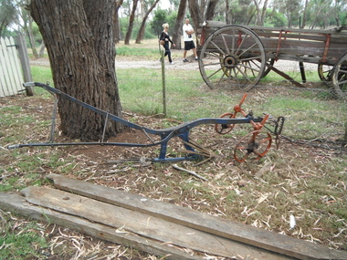
Tool - Potato digger
The potato digger was harnessed to horse or tractor and dragged through the potato mounds. This digger could be set for deep or shallow mounds. The horizontal flat shovel unearthed the potatoes. The iron raddle would agitate the potatoes free from the soil. Some diggers had prongs to flip potatoes to the side. The crop was then collected by hand. Previously the crop would be dug up by hand with hoes.Single row potato digger, with upward prongson digger and depth adjuster at rear. Green/blue with red wheelsfarm machinery, digging, harvesting, potatoes, horse drawn -
 Orbost & District Historical Society
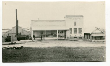
black and white photograph, 1917
This photograph shows the Orbost Butter factory, which in 1917, installed a very successful electric light. the dark heap to the left of the road is Supposedly the grave of "Dan the Cook" who was speared by Aborigines in 1857. Dan Moylan, known as "Dan the Cook"was speared to death in 1851 at Orbost Station, Snowy River as punishment for kidnapping a young Aboriginal girl and holding her for three days, refusing to release her. The men of the tribe congregated at Dan's hut. When Dan came outside, a volley of spears was launched at him, killing him. In the tragic aftermath, the camp at Milly Creek was attacked in retribution and a number of Gunai/Kurnai people were killed. The Orbost Butter and Produce Co. Ltd was registered on June 1st 1893 and was an important source of income to the Orbost district. These photos are pictorial records of the Orbsot Butter Factory.A black / white photograph showing a large white building and factory beside it. on the verandah are about thirty milk churns. There are three men standing astride bicycles in front of the verandah. On the left hand side is a mound of dark soil?? -
 Glenelg Shire Council Cultural Collection
Plan - Ship Plan / Mould, n.d
Wooden pattern for mould for boat fitting. 'Saddle' shaped piece, flat on top section with mound shaped sides; slopes down each side to rectangular section, which extends either end. Painted orange/yellow. -
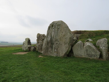 Ballarat Heritage Services
Photograph - Colour, Silbury Hill, Avebury World Heritage Site, Prehistoric Monuments, England, 2016
Colour photograph of the Silbury Hill, an immense Neolithic man-made mound part of the Avebury World Heritage Site. The Avebury World Heritage Site is a complex of outstanding prehistoric monuments comprising Windmill Hill (Early Neolithic enclosure and Bronze Age burial mounds); Silbury Hill; West Kennet Long Barrow; Avebury Stone Circles and West Kennet Avenue; The Sanctuary (site of stone and timber circles). It is part of National Trust and English Heritage. Visitors may walk to sites.Colour photograph of rocks at Avebury World Heritage Site avebury world heritage site, prehistoric monuments, rocks -
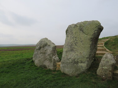 Ballarat Heritage Services
Photograph - Colour, Avebury World Heritage Site, Prehistoric Monuments, England, 2016
Colour photograph of the Silbury Hill, an immense Neolithic man-made mound part of the Avebury World Heritage Site. The Avebury World Heritage Site is a complex of outstanding prehistoric monuments comprising Windmill Hill (Early Neolithic enclosure and Bronze Age burial mounds); Silbury Hill; West Kennet Long Barrow; Avebury Stone Circles and West Kennet Avenue; The Sanctuary (site of stone and timber circles). It is part of National Trust and English Heritage. Visitors may walk to sites.Colour photograph of Avebury World Heritage Stte.avebury world heritage site, prehistoric monuments, rocks -
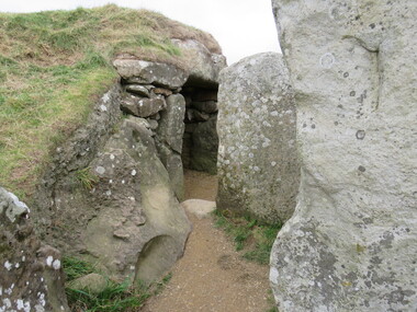 Ballarat Heritage Services
Photograph - Colour, Silbury Hill, Avebury World Heritage Site, Prehistoric Monuments, England, 2016
Colour photograph of the Silbury Hill, an immense Neolithic man-made mound part of the Avebury World Heritage Site. The Avebury World Heritage Site is a complex of outstanding prehistoric monuments comprising Windmill Hill (Early Neolithic enclosure and Bronze Age burial mounds); Silbury Hill; West Kennet Long Barrow; Avebury Stone Circles and West Kennet Avenue; The Sanctuary (site of stone and timber circles). It is part of National Trust and English Heritage. Visitors may walk to sites.Colour photograph of Avebury World Heritage Site. avebury world heritage site, prehistoric monuments, rocks -
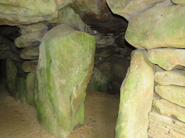 Ballarat Heritage Services
Photograph - Colour, Avebury World Heritage Site, Prehistoric Monuments, England, 2016
Colour photograph of the Silbury Hill, an immense Neolithic man-made mound part of the Avebury World Heritage Site. The Avebury World Heritage Site is a complex of outstanding prehistoric monuments comprising Windmill Hill (Early Neolithic enclosure and Bronze Age burial mounds); Silbury Hill; West Kennet Long Barrow; Avebury Stone Circles and West Kennet Avenue; The Sanctuary (site of stone and timber circles). It is part of National Trust and English Heritage. Visitors may walk to sites.Colour photograph of Avebury World Heritage Site.avebury world heritage site, rocks, prehistoric monuments -
 Ballarat Heritage Services
Photograph - Colour, Wayne Phillipson, Avebury World Heritage Site, Prehistoric Monuments, England, 2016
Colour photograph of the Silbury Hill, an immense Neolithic man-made mound part of the Avebury World Heritage Site. The Avebury World Heritage Site is a complex of outstanding prehistoric monuments comprising Windmill Hill (Early Neolithic enclosure and Bronze Age burial mounds); Silbury Hill; West Kennet Long Barrow; Avebury Stone Circles and West Kennet Avenue; The Sanctuary (site of stone and timber circles). It is part of National Trust and English Heritage. Visitors may walk to sites.Colour photograph of the Avebury World Heritage Site.prehistoric monuments, avebury world heritage site, rocks -
 Ballarat Heritage Services
Photograph - Colour, Wayne Phillipson, Avebury World Heritage Site, Prehistoric Monuments, England, 2016
Colour photograph of the Silbury Hill, an immense Neolithic man-made mound part of the Avebury World Heritage Site. The Avebury World Heritage Site is a complex of outstanding prehistoric monuments comprising Windmill Hill (Early Neolithic enclosure and Bronze Age burial mounds); Silbury Hill; West Kennet Long Barrow; Avebury Stone Circles and West Kennet Avenue; The Sanctuary (site of stone and timber circles). It is part of National Trust and English Heritage. Visitors may walk to sites.Colour photograph of Avebury World Heritage Site. avebury world heritage site, prehistoric monuments, rocks -
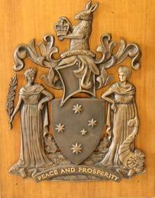 Wodonga & District Historical Society Inc
Sign - 2 Victorian State Shields from the Wodonga Court house
The Royal Warrant assigning the Armorial Bearings to Victoria was signed on the 6th June, 1910 by King George V. The motto Peace and Prosperity was the first to be in English among the Arms of any Public Authority in Australia. In 1958 the Pink Heath was proclaimed as the floral emblem of Victoria. This led to a request to have it included somewhere in the Armorial Ensigns of the State. The solution was to have the plant shown growing from a grassy mound. On the 28 March 1973 Queen Elizabeth II signed a further Royal Warrant which added the mound. This shield is the official emblem of the State of Victoria. It can only be displayed in limited place such as Law Courts and Victorian Government offices with permission of the Victorian Government.2 Victorian Coat of Arms from the Victorian State Government offices in Wodonga. The kangaroo at the top holds a crown. The shield also features the Southern Cross. Two female figures represent Peace and Prosperity. The figure on the left wears a laurel wreath crown and carries a sprig of olive in her hand, representing Peace. The other figure wears a crown of golden cereal and holds the horn of cornucopia, representing abundance or Prosperity. The first one is mounted on a wooden, varnished board.At the bottom of each shield "'PEACE AND PROSPERITY"shield, heraldry, victorian state government -
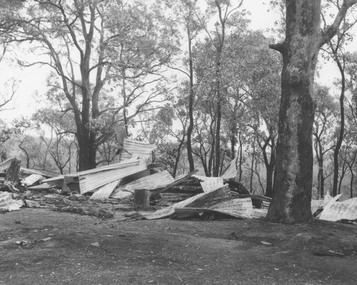 Ringwood and District Historical Society
Photograph, Ringwood Rifle Range after the bushfires of January 1962
Black and white photographTyped on back of photograph- "Ringwood Rifle Range after the bushfires of January 1962. Remains of 20 x 12 hut between the 5 and 600 yard mounds. Value £256 ." -
 Beechworth RSL Sub-Branch
Harry R Howe Metals
First to the right Australian service awarded for full time duty let then 18 month 2 from the rightwar medal 1939-45 awarded for full time duty in the armed forces for not less then 18 days in continuous service 3 from the right defence metal awored six months in non operation to or closely threatened by air tack 4 from the right pacific star Africa star 1939-45 star Replica set of Court mounded medal bar containing 6 medals, Australian Service Medal; 1939/45 Medal, Australian Defence Medal; Pacific Star, Africa Star with Eight Army Clasp and 1939/45 Star. with broach clasp on the reverse side for wearing.wwii war medals, court mounted medals, australian service medal -
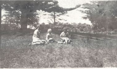 Port Fairy Historical Society Museum and Archives
Photograph
Norfolk Pine (near bandstand) - Gardens 1926black and white Photograph with a family groupgardens, norfolk pine, botanical, family, people, children, mound -
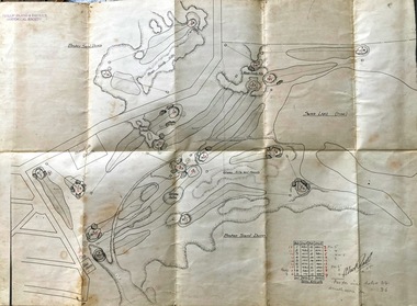 Phillip Island and District Historical Society Inc.
Map, Map of Summerland Golf Course, 15/12/1927
Summerlands Estate was created in the 1920s by A.K. T. Sampbell. It consisted of a housing estate, guest house and golf course. This area was acquired and all buildings, roads etc removed by the Victorian Government in the 1980s for a nature reserve for the penguins. This is believed to be the only time in the world when humans have been removed to benefit nature. HistoricalPurple leather covered fold out linen map with hand drawn diagram of the topography, layout of golf holes and club house Broken sand dunes, rough sandy hills, grassy hills and mounds, Swan Lake, Par for nine holes 34, Scratch score for nine holes 36, Drawn by A. Russell 12/12/1927summerland estate, summerlands golf course, a.k. t. sampbell, map, penguin reserve -
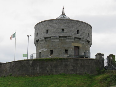 Ballarat Heritage Services
Digital Photograph, Tower, Drogheda, Ireland, 2016, 09/2016
The great mill mound is reported to be the burial ground of Amergin, and early Celtic poet. It was used as a fortified motte and bailey by the Normans during the 12th century. It later offered resistance to Cromwell in 1649. the present tower was built in 1808 but was damaged in 1922 during the Civil War in Ireland.drogheda, ireland -
 Port of Echuca
Coloured Photograph, 04/03/1984
The P.S Adelaide was launched on 21st July 1866. It was owned by J.G.Grassie from Poon Boon Station and the Officer Family of Murray Downs Station Swan Hill. The Adelaide was named after the niece of the Officer Bros, Adelaide Blackwood. The shipwright who built her was George Linklater. The Adelaide brought wool and passengers from the wool stations on the Murray and Darling Rivers down to the Echuca Wharf. In 1872 she was sold to David Blair & Sons. She was used to bring timber from the Barmah Forest to the Echuca Wharf. She did this work for the next 80 years. In 1953 she was tied up near the Mill and left. In 1958 she went to Paringa South Australia to work in the sawmill industry again. In 1960 the Echuca Apex Club and The Echuca Historical Society raised enough funds to buy the P.S. Adelaide and return her to Echuca. In November 1963 she was lifted out of the water and placed in Hopwood Gardens as this was thought to be a way of preserving her. In 1984 it was decided to return her to the water to resume work as a passenger vessel. In that time the Port of Echuca and the Echuca Wharf had been restored as a Tourist Precinct. This photograph shows the beginning of the task to return her to the river. It took several weeks in March 1984.The P.S Adelaide is extremely significant as it it the oldest known wooden hulled paddle steamers in the world. She was built in Echuca in 1866 and still operates on the Murray River today. She has worked in the Wool Industry, the Timber Industry and the Tourist Industry.This is a coloured square photograph of an orange front end loader clearing a track from Hopwood Gardens down to the river. The track was used to bring the P.S Adelaide from the gardens back into the river. The P.S Adelaide is in the background. The paddle steamer appears to be up on a trailer of some sort and is surrounded but plastic orange temporary fencing. There are small mounds of soil in the foreground.On the orange front end loader are the numbers "5900" and the word "case." p.s. adelaide, grassie, j.g, port of echuca, linklater, george, poon boon station, blair, david, murray river, darling river, logging industry, officer brothers., barmah forest, fulton & shaw, hutchinson, kevin, murray downs station, blackwood, adelaide -
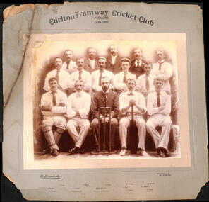 Melbourne Tram Museum
Photograph - Black and White photograph - mounted, E. Strawbridge, 1900
Mounted black and white photograph of the Carlton Tramway Cricket Club, Premiers 1899-1900 - has 15 men in the photos, most wearing the cricket clothes along with a set of stumps. Mounded on a grey embossed card with the image glued to the card. Each person named along the bottom edge. See Key Associations Image by E. Strawbridge of 129 Park St Parkville.trams, tramways, carlton depot, cable trams, sports, cricket -
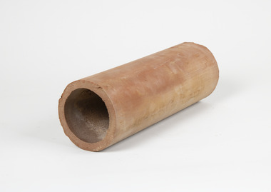 Merbein District Historical Society
Tool - Aggie pipe
with early in precise furrow irrigation ground water mounds developed on blocks which were detrimental to vine growth Aggie pipes were laid on grade on the clay layer of soil 4 to 5 foot deep or every 4th row of vines (forty four feet apart) to drain the perched water table and the accumulated salts from the vines root zone with early in precise furrow irrigation ground water mounds developed on blocks which were detrimental to vine growth Aggie pipes were laid on grade on the clay layer of soil 4 to 5 foot deep or every 4th row of vines (forty four feet apart) to drain the perched water table and the accumulated salts from the vines root zone Long clay cylinder horticulture, merbein, irrigation, pipes, furrow irrigation -
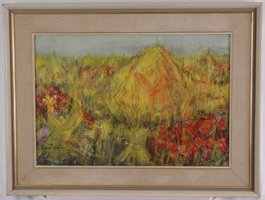 Glenelg Shire Council Cultural Collection
Painting, Isabel Huntington, Poppies in Flanders Field, 1968
CEMA Art Collection Winner of 1968 Portland Art Society Prize for the category of other media.The painting is an abstract depiction of a field which is predominantly yellow with patches of red. The largest red patches are in the lower right corner and centre left side. Another focus point of the work is a large yellow mound slightly off centre which may represent a haystack. The background is a light blue sky. The work has a painted wooden frame with material mount and glass covering only the paint surface.Front: Huntington (signature, lower left) Back: ISABEL HUNTINGTON "POPPIES IN FLANDERS FIELD" (1968) (typed label) Yellow Sticker: 1968-cema, portland artists society, wwi -
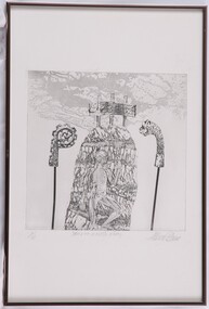 Glenelg Shire Council Cultural Collection
Print, Allan Mann, Ikon to a Fossil King, c. 1982
NoneAbstract image. Centre image is a human (shown without skin) climbing a narrow mound/hill form. At the top is a screen supported by three poles. The screen reproduces a photograph of what appears to be a classical narrative bas-relief sculpture. On each side of the hill are Celtic and Norse carvings/gilded artefacts/metalworks mounted on long poles. Abstract could patterns are at the top of the print. No matt. Silver metal frame.Front: 1/10 (lower left) Ikon to a Fossil King (lower centre) Allan Mann (lower right) (pencil) Back: (no inscriptions) -
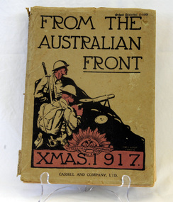 Orbost & District Historical Society
book, Cassell and Company Limited, From The Australian Front, 1917
This book was produced as a gift for Australian soldiers and their families on the Western Front in 1917. In the introduction General Birdwood, Commander of the ANZACS, explained it was for ‘…those whom we left behind in Australia, and who we know are thinking of us, some idea of our surroundings on the battle fronts…’.This book is a significant contemporary record of life for the Australian soldiers on the Western Front during World War 11.Grey cardboard covered 128 pp book with black and red writing on cover. the title, "FROM THE AUSTRALIAN FRONT" is in black print at the top above a black drawn sketch of two soldiers behind a mound and holding bayonets. at the foot is XMAS. 1917 inside a red rectangle with the insignia of the Australian Army (the rising sun) at the top. It contains cartoons, illustrations and photographs created by the soldiers themselves and put together in the style of an annual. military book-from-the-western-front world-war-11 -
 Eltham District Historical Society Inc
Photograph, Fay Bridge, Remains of apple orchard near the Diamond Creek, Wattle Glen, 11 October 2018
The newly constructed Diamond Creek Trail from Diamond Creek to Wattle Glen completed in February 2021 winds past these apple trees that possibly lined the entrance to the Greenhills property From Jean Verso, Nillumbik Historical Society, 15 April 2021 William Wandless Herbert bought the surrounding 100 acres in 1852. He was a native of Northumberland and the Scottish Borders who arrived in Melbourne in 1847. The house on the top of the mound would have been built not long after he bought the land; the farm was named "Greenhills". He married Elizabeth Wilson, daughter of John Wilson who had been in Diamond Creek since about 1846. Their first child was born in 1854 so there would be some form of dwelling from about that time. They had eight children who all survived to a good age. His will describes the house as part stone and part wood and of four rooms. Nillumbik Historical Society (NHS) believe it was one of the earliest if not the earliest house, in this part of the district. The remains of the stone house foundations are on top of the mound (photos on the VHD page) and the barn walls are on the north and to the east side of the mound. NHS is not sure how much or which part of the surrounding area was covered by the barns but they were large enough to hold dances after the race meetings that were held in the late 1880's on the adjacent creek flats. It would make sense with the lay of the land that they covered some of the ground to the north and east and used for farm storage, packing sheds for their apple and pear orchards and also for supporting the Nillumbik Gold Mine the family worked to the north up the gully. The path that comes down the gully and runs into the trail goes past the mine site which was on the west side of the gully a couple of hundred metres up from the flats. Heritage Victoria link for the site - https://vhd.heritagecouncil.vic.gov.au/places/12203fay bridge collection, 2018-10-11, diamond creek, diamond creek trail, elizabeth wilson, greenhills, wattle glen, william wandless herbert, apple trees -
 Vision Australia
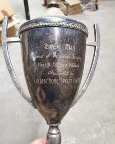
Award - Image, River Run trophy
A metal cup with handles and lid sits on top of a plastic mound. Inscribed on the cup are the words "River Run, Winner of Perpetual Trophy, Health Fitness & Vitality, Presented by Golden Bowl Sports Centre". At the base of the award are listed the names of past winners: 1978 Rob Wallace, 1979 Eric Sigmont, 1980 Rod Pitt, 1981 Robert Gilfillin, 1982 Eric Sigmont, 1983 Max Little, 1984 Dennis Clark, 1985 Michael Hillardt, 1986 Robin Rishworth, 1987 Malcolm Norwood. Image of tarnished metal cup with lid and two handlesRiver Run, Winner of Perpetual Trophy, Health Fitness & Vitality, Presented by Golden Bowl Sports Centreassociation for the blind, awards -
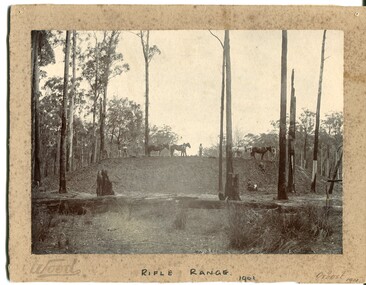 Orbost & District Historical Society
black and white photograph, Wood, 1901
This photograph appears to have been taken during the construction of the rifle range just north of the Orbost township. "The photo shows the range stop butt being formed by the scoops being pulled by the horses. It appears that the rear of the mound there is a wall of logs lining it, most likely to help with being eroded or washed away. They haven’t yet formed the mantlet and target machines." ( Info, from Victorian Rifle Association) The Orbost Rifle Club existed in the early 20th century. (There are records from 1900). It folded in the late 1970's.Target shooting is one of the oldest organised sports in Australia. Records date back to the British Marines at Sydney Cove in 1788. The Victorian Rifle Association (VRA) was formed in 1860. After Federation in 1901, rifle clubs came under army control, but in 1921 they were reconstituted as a civilian organisation, which they have remained ever since. After World War I a system of national training was embodied in the Defence Act and the rifle clubs reverted to their purely sporting role. A black / white photograph of four men and four horses standing an a soil bank with another man, a lady and a small girl at the base of the hill. It is in a clearing in forest. It appears to have a row of targets set at the edge of the bank. The photograph is mounted on a very mouldy cream coloured buff card.on front - "Wood" ; "Rifle Range - 1901" ; "Orbost 1901"sport-shooting orbost-rifle-range -
 Eltham District Historical Society Inc
Photograph, Fay Bridge, Ruins beside the Diamond Creek at Wattle Glen, 13 October 2016
The newly constructed Diamond Creek Trail from Diamond Creek to Wattle Glen completed in February 2021 winds around these ruins just pass the high transmission power lines near Herberts Lane and Collard Drive From Jean Verso, Nillumbik Historical Society, 15 April 2021 William Wandless Herbert bought the surrounding 100 acres in 1852. He was a native of Northumberland and the Scottish Borders who arrived in Melbourne in 1847. The house on the top of the mound would have been built not long after he bought the land; the farm was named "Greenhills". He married Elizabeth Wilson, daughter of John Wilson who had been in Diamond Creek since about 1846. Their first child was born in 1854 so there would be some form of dwelling from about that time. They had eight children who all survived to a good age. His will describes the house as part stone and part wood and of four rooms. Nillumbik Historical Society (NHS) believe it was one of the earliest if not the earliest house, in this part of the district. The remains of the stone house foundations are on top of the mound (photos on the VHD page) and the barn walls are on the north and to the east side of the mound. NHS is not sure how much or which part of the surrounding area was covered by the barns but they were large enough to hold dances after the race meetings that were held in the late 1880's on the adjacent creek flats. It would make sense with the lay of the land that they covered some of the ground to the north and east and used for farm storage, packing sheds for their apple and pear orchards and also for supporting the Nillumbik Gold Mine the family worked to the north up the gully. The path that comes down the gully and runs into the trail goes past the mine site which was on the west side of the gully a couple of hundred metres up from the flats. Heritage Victoria link for the site - https://vhd.heritagecouncil.vic.gov.au/places/12203fay bridge collection, 2016-10-13, diamond creek, diamond creek trail, ruins, wattle glen, william wandless herbert, greenhills, elizabeth wilson -
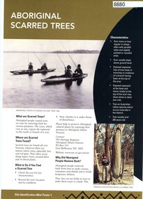 Greensborough Historical Society
Poster, Victoria. Department of Natural Resources and Environment, Site identification mini poster (#1-2, 4-6, 8-10, 13-14), 2002
This set produced by the Victorian Department of Natural Resources and Environ met and Aboriginal Affairs Victoria. Mini poster 1: Aboriginal scarred trees; 2 Aboriginal mounds; [3 missing]; 4 Aboriginal flaked stone tools; 5 Aboriginal burials; 6 Aboriginal surface scatters; [7 missing]; 8 Aboriginal ground-edge axes; 9 Aboriginal grinding stones; 10 Aboriginal stone arrangements; [11 missing]; 12 Aboriginal axe-grinding grooves; 13 Aboriginal coastal shell middens; 14 Aboriginal rock art.11 parts of incomplete set, each two sided, text and photographsaborigines - victoria, aboriginal affairs victoria -
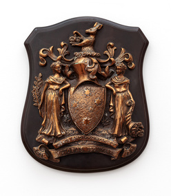 Bayside Gallery - Bayside City Council Art & Heritage Collection
Plaque, Victorian Coat of Arms, 150 Years, c. 1984
A dark wooden plaque with the Victorian coat of arms in metal relief of two female figures standing on a mound of grass on either side of the Southern Cross shield. The figure on the left represents Peace and holds an olive branch, while the figure on the right personifies Prosperity and holds a cornucopia. Above the shield is a knight's helmet and a kangaroo holding an Imperial crown. The motto 'PEACE AND PROSPERITY' is on a banner below the shield and under that a banner read's 'VICTORIA'S 150th YEAR' and the dates 1834 and 1984. The plaque is numbered 59 of 1,000 on the reverse.victorian coat of arms, plaque, shield, coat of arms, peace and prosperity, victoria's 150th year, heraldry