Showing 23 items matching "mountain view estate"
-
 Kew Historical Society Inc
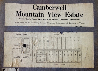
Plan - Subdivision Plan, Camberwell Mountain View Estate, 1923
... Camberwell Mountain View Estate......mountain view estate...The so-called Camberwell Mountain View Estate was a subdivision on ‘the corner [of] Burke Road, Eyre and Wills Streets, Deepdene’. ...Barnes. subdivision plans - camberwell mountain view estate The so-called Camberwell Mountain View Estate was a subdivision on ‘the corner [of] Burke Road, Eyre and Wills Streets, Deepdene’. ...The Kew Historical Society collection includes almost 100 subdivision plans pertaining to suburbs of the City of Melbourne. Most of these are of Kew, Kew East or Studley Park, although a smaller number are plans of Camberwell, Deepdene, Balwyn and Hawthorn. It is believed that the majority of the plans were gifted to the Society by persons connected with the real estate firm - J. R. Mathers and McMillan, 136 Cotham Road, Kew. The Plans in the collection are rarely in pristine form, being working plans on which the agent would write notes and record lots sold and the prices of these. The subdivision plans are historically significant examples of the growth of urban Melbourne from the beginning of the 20th Century up until the 1980s. A number of the plans are double-sided and often include a photograph on the reverse. A number of the latter are by noted photographers such as J.E. Barnes.The so-called Camberwell Mountain View Estate was a subdivision on ‘the corner [of] Burke Road, Eyre and Wills Streets, Deepdene’. The Estate was not the first attempt to subdivide this land holding. In 1884, 1888 and 1894 the Belmore Park subdivision proposed 18 allotments for this parcel of land. The final stages of the Belmore Park subdivision occurred during the Depression of the 1890s. Apart from perhaps one block facing Burke Road, which is unnumbered in the Mountain View Estate subdivision, the rest must have remained unsold. The later subdivision would redraw the original 18 allotments, creating 22 new lots. In the Locality Plan on the left side of the subdivision plan, Deepdene Station, which formed part of the Outer Circle Railway is represented, as is the location of Deepdene Primary School. A selling point was the proposed extension of the Burke Road tram beyond its terminus at Cotham Road. The extension did not eventuate.subdivision plans - camberwell, mountain view estate -
 Ringwood and District Historical Society
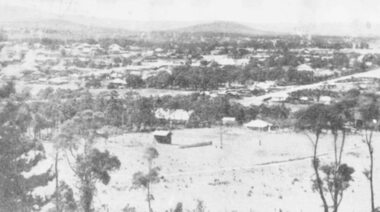
Photograph, A panorama of Ringwood from Mountain View Estate, Loughnan's Hill. (no date)
... A panorama of Ringwood from Mountain View Estate, Loughnan's Hill. (no date)...Typed below photograph, "A Panorama of Ringwood" and written on back of photograph, "Mountain View estate circular"....Ringwood and District Historical Society 125A Warrandyte Road Ringwood North melbourne Typed below photograph, "A Panorama of Ringwood" and written on back of photograph, "Mountain View estate circular". A panorama of Ringwood from Mountain View Estate, Loughnan's Hill. ...Typed below photograph, "A Panorama of Ringwood" and written on back of photograph, "Mountain View estate circular". -
 Ringwood and District Historical Society
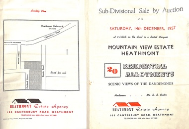
Flyer - Land Sales Brochure, Sub-Divisional Sale by Auction - Mountain View Estate, Heathmont, Victoria - 1957
... Sub-Divisional Sale by Auction - Mountain View Estate, Heathmont, Victoria - 1957...Sub-Divisional Sale by Auction - Mountain View Estate, Heathmont, Victoria - 1957 Flyer Land Sales Brochure ...Bi-fold pamphlet advertising auction of 20 residential allotments on Saturday, 14th December, 1957, with description of services available and finance terms. Subdivision inclues Orchard Grove and Barnic Road. Agent - Heathmont Estate Agency, 103 Canterbury Road, Heathmont, Telephone WU6808, after hours WF1488. Auctioneer Mr. A.B. Carter. Accompanying Parish of Ringwood survey map with cardboard backing - Part of Crown Allotment 14B, includes handwritten price notations for each allotment. -
 Ringwood and District Historical Society
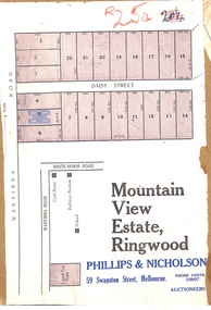
Map, Partially Trimmed Copy of Mountain View Estate Subdivision Advertisement, Ringwood, Vic. - (Undated, circa 1930s)
... Partially Trimmed Copy of Mountain View Estate Subdivision Advertisement, Ringwood, Vic. - (Undated, circa 1930s)...Partially Trimmed Copy of Mountain View Estate Subdivision Advertisement, Ringwood, Vic. - (Undated, circa 1930s) Map ...Clipped subdivision map on cardboard backing. 22 residential allotments on Daisy Street and Wantirna Road, Ringwood.Auctioneers - Phillips & Nicholson, 59 Swanston Street, Melbourne. Phone Central 10907. -
 Ringwood and District Historical Society
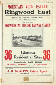
Flyer, Land Sale Brochure, Mountain View Estate, Ringwood East, Vic. - 1923
... Land Sale Brochure, Mountain View Estate, Ringwood East, Vic. - 1923...Land Sale Brochure, Mountain View Estate, Ringwood East, Vic. - 1923 Flyer ...Bi-fold advertisement for sale of residential allotments, including photographs, map, and summary of subdivision features and local facilities. Undated handwritten notation reads "streets don't exist today".Subdivision layout includes Mullum Mullum Road, Rangeview Avenue, Press Avenue, and Mountview Avenue. Local Agent - J.B. McAlpin, Opposite Railway Station, Ringwood, Phone Ringwood 7. Vendor - T.J. Press, Builder, "Monterey", Second Avenue, Kew, Telephone Haw. 3428. -
 Ringwood and District Historical Society
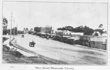
Photograph, Maroondah Highway Central, Ringwood. Main Street, looking west from Warrandyte Rd, c1924
... Typed on back of one small photograph: "Coped from a circular for Mountain View Estate, J. Press, vendor, Second Av. ...Typed on back of one small photograph: "Coped from a circular for Mountain View Estate, J. Press, vendor, Second Av. ...Black and white photograph (2 copies- 1 large, 2 small) Typed below large photograph: "Main St looking west from Warrandyte Rd, c1924." Typed on back of one small photograph: "Coped from a circular for Mountain View Estate, J. Press, vendor, Second Av. Kew. In Mullum Rd, 90 yds from Oban Rd. Press, Rangeview & Mountview Avenues. Winnington just completed. 1924." -
 Ringwood and District Historical Society
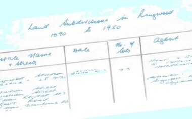
Document - Research Notes, Richard Carter, Land Subdivisions in Ringwood 1890-1950
... £460 Pg37 MOUNTAIN VIEW ESTATE LP10902 (1936) Lots 1&2, 19-22 Wantirna Road, Daisy Street £50 Pg38 RAILWAY STATION ESTATE RINGWOOD EAST LP7522 (1925) Lots 16 to 19 £250 Pg38 RINGWOOD PARK ESTATE (LP?) ...£460 Pg37 MOUNTAIN VIEW ESTATE LP10902 (1936) Lots 1&2, 19-22 Wantirna Road, Daisy Street £50 Pg38 RAILWAY STATION ESTATE RINGWOOD EAST LP7522 (1925) Lots 16 to 19 £250 Pg38 RINGWOOD PARK ESTATE (LP?) ...Handwritten table listing main local pre-1950s subdivisions in the Ringwood area, with estate names, streets, number of allotments for sale, and where known, vendor agent, LP (Lodged Plan) title registration number, and auction/sale date, some with sale price.Pg1 RINGWOOD STATION ESTATE LP3070 (Year?) Station Street, William Street (now Kendall Street), Wantirna Road, Station Street Pg1 RINGWOOD TOWNSHIP ESTATE LP5577 (1913) Station Road (now Warrandyte Road), Pratt Street (part now Aird Street), Whitehorse Road Pg2 RINGWOOD ORCHARD ESTATE LP4315 (1914) Brysons Road, Hillcrest Road, Anzac Avenue, Sulva Road Pg3 RINGWOOD RAILWAY ESTATE LP7522 (1918) Whitehorse Road (now Mount Dandenong Road), Dublin Road, Freeman Street, Patterson Street, Bona Street Pg4 THE RINGWOOD ESTATE LP7578 (1919) Warrandyte Road, Hobart Street, Paxton Street, Arnold Street Pg5 GARDEN FARMS ESTATE (LP?) (1919) Canterbury Road, Armstrong Road, Bungalook Road, Orchard Road, Bayswater Road (now Mountain Highway) Pg6 THE RINGWOOD ESTATE (SECOND SUB-DIVISION) LP7604 (1919) Warrandyte Road, Tamar Street, Derwent Street, Mersey Street Pg7 RINGWOOD STATION ESTATE LP7703 (1919) Bedford Road, Williams Grove (now Lena Grove) Pg8 RINGWOOD TOWNSHIP ESTATE LP8198 (1919) Wantirna Road, Ellison Street, Haig Street, Greenwood Avenue Pg9 EASTFIELD ESTATE (LP?) (1920) Eastfield Road, Longview Road, Pleasant Rise, The Mount Pg10 ELECTRIC RAILWAY ESTATE RINGWOOD LP9473 (1922) Campbell Street, Myrtle Avenue, George Street (now Tudor Court), Henry Street (now Myrtle Avenue), Williams Grove (now Lena Grove) Pg11 RINGWOOD PARK ESTATE LP7884 (1922 - two stages) Wonga Road (now Loughnan Road), William Street, Andrew Street, Harrison Street Pg12 HEATHMONT STATION ESTATE LP11009 (Date? - after 1922) Lisgoold Street, Viviani Crescent, Balrour Avenue, Station Street (now part Heathmont Road and part Wainui Street) Pg13 RINGWOOD RAILWAY ESTATE LP10507 (1923) Whitehorse Road, Sherbrooke Avenue, Burwood Avenue, Bonview Avenue, Heatherbrae Avenue, Grant Crescent Pg14 GARDEN HOMES ESTATE (LP?) (1923) Mullum Road, The Centreway, Wattle Crescent (now Wattle Avenue) Reserve Crescent (now Reserve Road) Pg15 DUBLIN ROAD ESTATE LP11993 (1923) Alexandra Road, Vonadawn Avenue, Green Street, Wood Street, Howard Avenue, Bedford Road, Dublin Road Pg16 CARLINGA ESTATE RINGWOOD LP9620 (1923) Bourke Street, Bond Street, Ringwood Street Pg17 PRATT'S JUNCTION ESTATE (LP?) (1923) Junction Street, Georges Road, Oliver Street, Whitehorse Road Pg18 EAST RINGWOOD ESTATE LP10492 (1923) Bona Street, Patterson Street, Miller Grove, Fairview Avenue, Eastfield Road, Whitehorse Road (now Mount Dandenong Road) Pg19 COLEMAN'S HEATHMONT ESTATE LP9974 (1923) Canterbury Road, Bedford Road, Alvena Crescent, Coleman Street, Leonard Street (now Royal Avenue) Pg20 RINGWOOD HEIGHTS ESTATE LP10506 (1924) Whitehorse Road, Bonview Avenue, Grant Crescent, Hillcrest Avenue, Heatherbrae Avenue, Margaret Street, Mary Street Pg21 EAST RINGWOOD STATION ESTATE LP10551 (1924) Knaith Road, Wenwood Street, Lois Street, Victoria Street, Station Street (now Railway Avenue) Pg22 GRAND VIEW ESTATE LP11019 (1924) Whitehorse Road, Rupert Street, Herbert Street, Leonard Street Pg23 RINGWOOD RAILWAY ESTATE & RINGWOOD HEIGHTS ESTATE - FINAL SECTIONS LP10506 & LP10507 (1924) Whitehorse Road, Sherbrooke Avenue, Burwood Avenue, Bonview Avenue, Heatherbrae Avenue, Margaret Street, Mary Street, Grant Crescent Pg24 RINGWOOD EAST ELECTRIC STATION ESTATE (LP?) (1924) Railway Parade (now Patterrson Street), Federal Road, Howship Avenue (part now French Street), Dublin Road, Rosedale Crescent Pg25 BEDFORD PARK (now Ringwood Secondary College) (LP?) (1924) Bedford Road, Adams Street, Anderson Street, Joyce Street, Graham Road Pg26 CROWN JEWEL ESTATE LP11645 (Private sales after 1924) Mount Dandenong Road, Mirabel Avenue, Valda Avenue, Evon Avenue, Velma Grove Pg27 GRAND CENTRAL ESTATE LP10917 (1925) Heathmont Road, Great Ryrie Street, Douglas Street, Garden Street, Bellevue Avenue Pg28 RINGWOOD (unnamed estate - 1926) Nelson Street, Seymour Street, Whitehorse Road Pg29 EAST RINGWOOD RAILWAY STATION ESTATE (YEAR? - 25 shops 60 villas) Railway Avenue, Dublin Road, Lawrence Grove, Stanley Avenue, Knaith Road Pg30 CHARM VIEW ESTATE (LP?) (year? - after 1926) Canterbury Road, Heathmont Road, Dickasons Road, Bennjett Avenue, Orchid Street Pg31 SUNBEAM ESTATE LP12150 (Circa 1925) Govt Road (now Old Lilydale Road), Sunbeam Avenue, Holland Road, Everard Street (now Everard Road) Pg32 FAIRVIEW ESTATE EAST RINGWOOD LP10853 (Circa 1924) Eastfield Road, Patterson Street, Margaret Street (now Short Street) Pg33 EAST RINGWOOD TOWNSHIP ESTATE LP3025 (Circa 1924 - 35 allotments) Mount Dandenong Road, Grey Street, Eastfield Road Pg34 EAST RINGWOOD TOWNSHIP ESTATE LP3025 (Circa 1924 - 49 allotments) and STATE SCHOOL ESTATE (26 allotments) and EAST RINGWOOD STATION ESTATE (14 shop sites) Mount Dandenong Road, Grety Street, Dunn Street, Eastfield Road, King Street, Holland Road, Dublin Road, Patterson Street, Bona Street Pg35 EAST RINGWOOD CENTRAL ESTATE LP17004 (1948) Knaith Road, Shasta Avenue, Talofa Avenue, Russet Road, Dublin Road Pg36 WARE ESTATE LP43360 (1958) Ware Crescent, Davey Drive, Grey Road (now Grey Street), Mount Dandenong Road Pg37 Lot 57 Kendall Street LP3070 (1939) £75.0.0 Pg37 Lot 14 LP7346 (year?) £225 Pg37 Lot 8 WHITE HORSE ESTATE LP14010 (year?) Maroondah Hwy, Seymour Street £98.9.0 Pg37 Lots 4-14 incl. LP10902 (year?) £300 Pg37 Lots 69&70 LP2216 (1939) Bedford Road, Pitt Street £500 Pg37 Lots 60&70 LP2216 (year?) £460 Pg37 MOUNTAIN VIEW ESTATE LP10902 (1936) Lots 1&2, 19-22 Wantirna Road, Daisy Street £50 Pg38 RAILWAY STATION ESTATE RINGWOOD EAST LP7522 (1925) Lots 16 to 19 £250 Pg38 RINGWOOD PARK ESTATE (LP?) (1924) Lot 112 Munro Street £230 Pg38 RINGWOOD TOWNSHIP ESTATE (LP?) (1925) Lot 57 Wantirna Road £850 Pg38 ELECTRIC RAILWAY ESTATE LP9473 (1925) Lot 98 & 99 £180 (30/- foot) Pg38 ELECTRIC RAILWAY ESTATE LP9473 (year?) Lot 100 £233.12.6 incl improvements (£2.12.6 foot) Pg38 Lot 22&23 Bedford Road Heathmont (LP & year?) £675 incl improvements Pg39 Lot 9 Mullum Mullum Road LP8221 (1923) £150 Pg39 Lot 27 Haig Street LP8198 (1925) £825 Pg39 Lot 56 Haig Street cnr Wantirna Road LP8198 (1923) £171 Pg39 Lots 3 & 4 Loughnan Road LP9626 (192?) £147 Pg39 Lots 98 & 99 Myrtle Avenue LP9473 (1925) £180 Pg39 Lots 80 & 81 Myrtle Avenue LP9473 (1929) £150 Pg39 Lot 30 Sherbrooke Avenue LP10507 (1926) £700 incl improvements Pg40 Lot 10 (year?) LP7703 £750 Pg40 Lot 36 (year?) LP7522 £25 Pg40 Lot 38 Pitt Street LP2216 (year?) £350 Pg40 Lot 7 Dublin Road cnr Green Street LP11993 (year?) £300 -
 Greensborough Historical Society
Advertising Leaflet, Barry Plant Bundoora, Barry Plant Spring selling season, 2018_08
... Greensborough Historical Society 34A Glenauburn Road Lower Plenty Lower Plenty melbourne Spring selling season leaflet with sales results on back of page. 4 Murumba Street Greensborough, sold $1,115,000 ; 11 Sun Orchid Circuit St Helena sold $870,00; 6 Weemala Court Greensborough sold $1,666,000; 6 Howard Street Greensborough sold $737,000; 136 Elder Street Greensborough sold $772,000; 140 Mountain View Road Briar Hill sold $638,000 and 12 Sunrise Drive Greensborough sold 2018 for $1,320,000, previous sales January 1994 $103,000, July 1989 $100,000 and July 1988 $85,500. sunrise drive greensborough murumba street greensborough sun orchis circuit st helena elder street greensborough howard street greensborough mountain view road briar hill weemala court greensborough Real estate advertising leaflet, 1 sheet, printed in colour on both sides. ...Spring selling season leaflet with sales results on back of page. 4 Murumba Street Greensborough, sold $1,115,000 ; 11 Sun Orchid Circuit St Helena sold $870,00; 6 Weemala Court Greensborough sold $1,666,000; 6 Howard Street Greensborough sold $737,000; 136 Elder Street Greensborough sold $772,000; 140 Mountain View Road Briar Hill sold $638,000 and 12 Sunrise Drive Greensborough sold 2018 for $1,320,000, previous sales January 1994 $103,000, July 1989 $100,000 and July 1988 $85,500.Real estate advertising leaflet, 1 sheet, printed in colour on both sides.sunrise drive greensborough, murumba street greensborough, sun orchis circuit st helena, elder street greensborough, howard street greensborough, mountain view road briar hill, weemala court greensborough -
 Greensborough Historical Society
Advertising Leaflet, Buckingham & Company: Supporting the Local community, 28/07/2014
... On the reverse, 7 images of homes sold by Buckinghams in 2018: 13 Alban Street Montmorency ($1,850,000), 29 Banfield Terrace Greensborough ($1,061,000), 46 Cressy Street Montmorency ($1,400,000), 46 Mountain View Road ($940,000), 2/8 Wattle Avenue Montmorency ($1,320,000), 2A Rattray Road Montmorency ($670,500) and 3 Crellin Crescent Watsonia ($9000,000). buckingham & company real estate agents Real estate advertising leaflet, one sheet, printed in colour on one side. 7 small colour images pasted on reverse. ..."Buckingham & Company: Supporting the Local community, proud sponsors of these organisations". This leaflet lists some of the local organisations sposored by this company. On the reverse, 7 images of homes sold by Buckinghams in 2018: 13 Alban Street Montmorency ($1,850,000), 29 Banfield Terrace Greensborough ($1,061,000), 46 Cressy Street Montmorency ($1,400,000), 46 Mountain View Road ($940,000), 2/8 Wattle Avenue Montmorency ($1,320,000), 2A Rattray Road Montmorency ($670,500) and 3 Crellin Crescent Watsonia ($9000,000).Real estate advertising leaflet, one sheet, printed in colour on one side. 7 small colour images pasted on reverse.buckingham & company real estate agents -
 Greensborough Historical Society
Advertising Leaflet, 1/90 Mountain View Road Montmorency, 11/09/2015
... Greensborough Historical Society 34A Glenauburn Road Lower Plenty Lower Plenty melbourne 1/90 Mountain View Road Montmorency. 2 bedroom home, private sale, sold 01/03/2013 for $555,000; and i11/09/2015 for $680,000 mountain view road montmorency mountainview road Real estate advertising leaflet, 1 sheet, printed in colour both sides 1/90 Mountain View Road Montmorency Advertising Leaflet Buckingham and Company Estate Agents ...1/90 Mountain View Road Montmorency. 2 bedroom home, private sale, sold 01/03/2013 for $555,000; and i11/09/2015 for $680,000Real estate advertising leaflet, 1 sheet, printed in colour both sidesmountain view road montmorency, mountainview road -
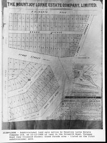 Lorne Historical Society
Map, F W Niven Lithos, The Mountjoy Lorne Estate, 1889
... A paper map of the Mountjoy Estate Lorne , showing allotments, with their owners, and naming land use. It has four black and white line drawings , Erskine House, Mountain View’s, the Rapids, Erskine House sea view and Erskine Falls. ...The subdivision map was printed in 1889 Lorne Subdivision map Erskine House Mountjoy Brothers A paper map of the Mountjoy Estate Lorne , showing allotments, with their owners, and naming land use. It has four black and white line drawings , Erskine House, Mountain View’s, the Rapids, Erskine House sea view and Erskine Falls. ...In 1888 a company was formed to acquire and subdivide the land of the Mountjoy Brothers. The land totaled 197 acres and included Erskine House. The land colored red was that of the Mountjoys. The subdivision map was printed in 1889A paper map of the Mountjoy Estate Lorne , showing allotments, with their owners, and naming land use. It has four black and white line drawings , Erskine House, Mountain View’s, the Rapids, Erskine House sea view and Erskine Falls. The map is largely black and white with red and blue colouring. The map is mstuck to brown paper. lorne, subdivision map, erskine house, mountjoy brothers, -
 Montmorency–Eltham RSL Sub Branch
Souvenir - Port Bottle (Imitation "Nato Round")
... Montmorency–Eltham RSL Sub Branch Petrie Park 16 Mountain View Road Montmorency melbourne Stamped with name of soldier "THE AUSTRALIAN ARMY" badge (below) The 7.62mm Rimless Nato Round CPL DELANEY R.J. A223121 1 DSU 1969-1970 (Side, Stamp indicating contents) PORT MT AITKEN ESTATES VICTORIA 375 ml - 18% alc vol (Underside, indented) F4 84 MF (Rear) Detailed background story of the "7.62mm Round" Ceramic container in shape of "Rimless Nato Round" Lid in shape of bullet "Rising Sun" badge with various inscriptions below and at rear Souvenir Port Bottle (Imitation "Nato Round") ...Stamped with name of soldier Ceramic container in shape of "Rimless Nato Round" Lid in shape of bullet "Rising Sun" badge with various inscriptions below and at rear"THE AUSTRALIAN ARMY" badge (below) The 7.62mm Rimless Nato Round CPL DELANEY R.J. A223121 1 DSU 1969-1970 (Side, Stamp indicating contents) PORT MT AITKEN ESTATES VICTORIA 375 ml - 18% alc vol (Underside, indented) F4 84 MF (Rear) Detailed background story of the "7.62mm Round" -
 Eltham District Historical Society Inc
Slide - Photograph, Aerial Photo (c.1987): Woodridge Estate, Eltham, c.Aug. 1990
... mountain roads of Kinglake. In the byways category are views of some iof the Shire's bicycle paths including then recently completed sections of the Main Yarra Trail at Lower Plenty. infrastructure roads aerial photographs eltham Housing estate Woodridge Estate 35mm colour positive transparency (1 of 37) Mount - Agfachrome Agfa CS System black 8 dots Aerial Photo (c.1987): Woodridge Estate, Eltham Slide Photograph ...Part of a presentation, "Roads and Byways of the Shire of Eltham", by Russell Yeoman to the 12 September 1990 Society meeting. Slides shown included copies of old photos and recent images ranging from the suburban streets of Eltham and Montmorency to the mountain roads of Kinglake. In the byways category are views of some iof the Shire's bicycle paths including then recently completed sections of the Main Yarra Trail at Lower Plenty.35mm colour positive transparency (1 of 37) Mount - Agfachrome Agfa CS System black 8 dotsinfrastructure, roads, aerial photographs, eltham, housing estate, woodridge estate -
 Eltham District Historical Society Inc
Photograph - Sepia Print, Unidentified hall; possibly the Montmorency Presbyterian Church Hall, Rattray Road, Greensborough, c.1918
... Estate', which had been established when the railway was extended to Eltham several years before, began meeting for worship in the Rattray Rd home of Robert Sharpe. Two years later a small weatherboard church, administered from Scots Church, Heidelberg, was built on land donated by Mr. Sharpe. In 1931 this building was moved to the corner of Rattray Road and Mountain View...Estate', which had been established when the railway was extended to Eltham several years before, began meeting for worship in the Rattray Rd home of Robert Sharpe. Two years later a small weatherboard church, administered from Scots Church, Heidelberg, was built on land donated by Mr. Sharpe. In 1931 this building was moved to the corner of Rattray Road and Mountain View ...From Eltham Montmorency Uniting Church, History http://www.elthammontmorencyuca.org/history/ In 1914 a small group of Presbyterians living on 'The Montmorency Estate', which had been established when the railway was extended to Eltham several years before, began meeting for worship in the Rattray Rd home of Robert Sharpe. Two years later a small weatherboard church, administered from Scots Church, Heidelberg, was built on land donated by Mr. Sharpe. In 1931 this building was moved to the corner of Rattray Road and Mountain View Roads. In the next few years local elders were elected and the congregation adopted the name St. Andrew’s Presbyterian Church, Montmorency.montmorency, montmorency presbyterian church hall, rattray road -
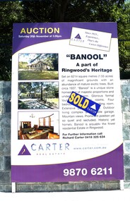 Ringwood and District Historical Society
Photograph, Di Bannister Photography, CE Carter's Auction Board for Banool Historic Homestead, Ringwood, 20 Nov 2004
... Mountain views. Prominent position yet so quiet and secluded. Historic yet homely, Banool is arguably the finest residential Estate in Ringwood. ...Mountain views. Prominent position yet so quiet and secluded. Historic yet homely, Banool is arguably the finest residential Estate in Ringwood. ...Photograph of auction board on wall outside the property at 57-59 Wonga Road, Ringwood North “BANOOL” A part of Ringwood's Heritage 57-59 Wonga Road Set on 6214 square metres (1.55 acres) of magnificent grounds with an abundance of mature exotic trees. Built circa 1937, “Banool” is a unique stone homestead of majestic proportions and undeniable charm. Glorious formal lounge and dining rooms. Four bedrooms plus informal sitting room. Extensive period features. Outdoor living complex and double garage. Mountain views. Prominent position yet so quiet and secluded. Historic yet homely, Banool is arguably the finest residential Estate in Ringwood. Sold for $1,615,000 to Maher family following CE Carter auction. Banool is a beautifully restored property in North Ringwood, on approximately 1.7 acres. Mature trees grace the property many pre-dating the stone home, built circa 1930s Paul Bangay designed the renovated gardens, linking these majestic trees with the home. -
 Ringwood and District Historical Society
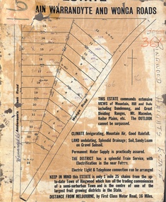
Map, Partially Trimmed Copy of Ringwood Heights Estate, Ringwood, Vic. - circa 1923
... Captions - This Estate commands extensive views of mountain, hill and dale including Dandenong and Great Dividing Ranges, Mt. ...Captions - This Estate commands extensive views of mountain, hill and dale including Dandenong and Great Dividing Ranges, Mt. ...Clipped copy of a subdivision advertisement on cardboard backing. Sales notations on numbered allotments in Andersons's Creek Road (later Warrandyte Road) and Wonga Road, Ringwood. Handwritten title reference - LP7305. Captions - This Estate commands extensive views of mountain, hill and dale including Dandenong and Great Dividing Ranges, Mt. Macedon, Keilor Plains, etc. The outlook cannot be surpassed. Climate invigorating, mountain air, good rainfall. Land undulating, splendid drainage; soil, sandy loam on gravel subsoil. Permanent water supply is practically assured. The district has a splendid train service, with electrification in the near future. Electric light & telephone connection can be arranged. Keep in mind this estate is only 1 mile 25 chains from the up-to-date town of Ringwood which has all the trading conveniences of a semi-suburban town and is the centre of one of the largest fruit growing districts in the state. Distance from Melbourne by first class motor road, 16 miles. -
 Ringwood and District Historical Society
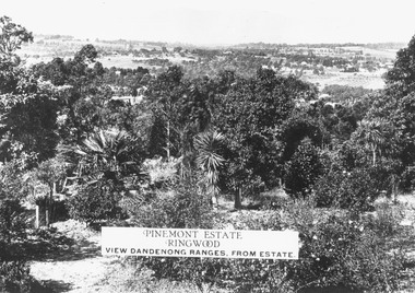
Photograph, Two images of view from Pinemont Estate, Loughnans Hill, looking east, c1930
... Estate, Ringwood. View Dandenong Ranges, from estate". Typed below photograph, "View from Loughnans Hill, looking east, c1930. Club Hotel can just be seen top right corner". Black and white photograph of view. Trees and bushes in foreground, orchards and mountains ...Black and white photograph of view. Trees and bushes in foreground, orchards and mountains towards background. (2 copies)Typed on photograph, "Pinemont Estate, Ringwood. View Dandenong Ranges, from estate". Typed below photograph, "View from Loughnans Hill, looking east, c1930. Club Hotel can just be seen top right corner". -
 Marysville & District Historical Society
Map (Item) - Tourist map, Murrindindi Shire Council, VISITOR INFORMATION & MAP LAKE MOUNTAIN, MARYSVILLE & TRIANGLE, 02-2010
... mountain...marysville...victoria...australia...visitor information & map...murrindindi shire council...big 4 holiday park taggerty...black spur inn...black spur motel & caravan park...bush creek buddha...buxton hotel motel...cathedral valley farm...chestnut glade...crossways historic country inn...delderfield luxury b&b...kingbilli country estate...marapana agistment park & farm stay b&b...maryton park b&b...pinjarra gardens...sarsens rest...silverstream b&b...tower motel...willowbank at taggerty...wombat cottage...woodlands rainforest retreat...buxton general store and post office...buxton zoo nursery...cathedral view...A visitor information map for Lake Mountain, Marysville and the local district produced by the Murrindindi Shire Council in February 2010. lake mountain marysville victoria australia visitor information & map murrindindi shire council big 4 holiday park taggerty black spur inn black spur motel & caravan park bush creek buddha buxton hotel motel cathedral valley farm chestnut glade crossways historic country inn delderfield luxury b&b kingbilli country estate marapana agistment park & farm stay b&b maryton park b&b pinjarra gardens sarsens rest silverstream b&b tower motel willowbank at taggerty wombat cottage woodlands rainforest retreat buxton general store and post office buxton zoo nursery cathedral view natural therapies country touch cross country ski hire foodworks highwood health retreat lake mountain ski hire lit & beyond lj hooker maroondah outdoor equipment/bait & tackle marysville medical centre marysville patisserie marysville ski centre marysville triangle real estate marysville visitor information centre mystic mountains ski hire/outdoors pat's hairdressing penni lanes country wares plant's by shelian Murrindindi Shire Council has made every effort to ensure the information provided at the time/ of printing is correct, but accepts no responsibility for an inaccuracies or omissions. ...A visitor information map for Lake Mountain, Marysville and the local district produced by the Murrindindi Shire Council in February 2010. This information guide and map was produced after the 2009 Black Saturday bushfires destroyed most of the township of Marysville.A visitor information map for Lake Mountain, Marysville and the local district produced by the Murrindindi Shire Council in February 2010.Murrindindi Shire Council has made every effort to ensure the information provided at the time/ of printing is correct, but accepts no responsibility for an inaccuracies or omissions.lake mountain, marysville, victoria, australia, visitor information & map, murrindindi shire council, big 4 holiday park taggerty, black spur inn, black spur motel & caravan park, bush creek buddha, buxton hotel motel, cathedral valley farm, chestnut glade, crossways historic country inn, delderfield luxury b&b, kingbilli country estate, marapana agistment park & farm stay b&b, maryton park b&b, pinjarra gardens, sarsens rest, silverstream b&b, tower motel, willowbank at taggerty, wombat cottage, woodlands rainforest retreat, buxton general store and post office, buxton zoo nursery, cathedral view natural therapies, country touch, cross country ski hire, foodworks, highwood health retreat, lake mountain ski hire, lit & beyond, lj hooker, maroondah outdoor equipment/bait & tackle, marysville medical centre, marysville patisserie, marysville ski centre, marysville triangle real estate, marysville visitor information centre, mystic mountains ski hire/outdoors, pat's hairdressing, penni lanes country wares, plant's by shelian -
 Marysville & District Historical Society
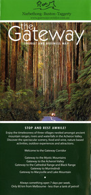
Map (Item) - Tourist and business map, Narbethong Community and Tourism Group, the Gateway TOURIST AND BUSINESS MAP, 08-2009
... A tourist and business map of Narbethong, Buxton and Taggerty. narbethong buxton taggerty victoria australia tourist and business map the gateway tourist and business map black spur motel & caravan park woodlands rainforest retreat chestnut glade black spur inn wombat cottage abbey lake luxury b&b spa cottages camp narbethong marapana farm stay b&b mantirri b&b little dene garden cottages nareen cabins silverstream b&b cottages buxton hotel motel south cathedral farm luxury b&b cottages cathedral view b&b retreat kingbilli country estate cathedral valley farm pinjarra gardens willowbank at taggerty sarsens rest yarrolyn caravan park danico design counted cross stitch things of sand & stone buxton zoo nursery safetrek 4wd services mystic mountains ski hire & outdoors pnl 4wdriving buxton trout and salmon farm buxton bait and tackle black spur roadhouse tudor lodge service station roadhouse & ski hire buxton roadhouse buxton p.o. general store igloo roadhouse henry v111 manor house buxton hotel butters cafe wagtail wines little river wines narby eggs marapana agistment park carmyle farm hazelwood hazelnuts cathedral view naturall therapies cre8ing growth linda hailey naby cabinets gb timber narbethong timber & trading rb automotive repairs buxton car care martyn slade building design taggerty vet clinic This publication has been produced by the Narbethong Community and Tourism Group Inc./ (NCTG) The information provided in this publication has been supplied by the individual/ members. ...A tourist and business map of Narbethong, Buxton, and Taggerty. This map was produced by the Narbethong Community and Tourism Group Inc in August 2009. It was produced to promote the natural attractions, adventure activities, and food trail from the Black Spur, through Narbethong, Buxton, and Taggerty.A tourist and business map of Narbethong, Buxton and Taggerty.This publication has been produced by the Narbethong Community and Tourism Group Inc./ (NCTG) The information provided in this publication has been supplied by the individual/ members. NCTG takes no responsibility for its accuracy./ August 2009narbethong, buxton, taggerty, victoria, australia, tourist and business map, the gateway tourist and business map, black spur motel & caravan park, woodlands rainforest retreat, chestnut glade, black spur inn, wombat cottage, abbey lake luxury b&b spa cottages, camp narbethong, marapana farm stay b&b, mantirri b&b, little dene garden cottages, nareen cabins, silverstream b&b cottages, buxton hotel motel, south cathedral farm luxury b&b cottages, cathedral view b&b retreat, kingbilli country estate, cathedral valley farm, pinjarra gardens, willowbank at taggerty, sarsens rest, yarrolyn caravan park, danico design counted cross stitch, things of sand & stone, buxton zoo nursery, safetrek 4wd services, mystic mountains ski hire & outdoors, pnl 4wdriving, buxton trout and salmon farm, buxton bait and tackle, black spur roadhouse, tudor lodge service station roadhouse & ski hire, buxton roadhouse, buxton p.o. general store, igloo roadhouse, henry v111 manor house, buxton hotel, butters cafe, wagtail wines, little river wines, narby eggs, marapana agistment park, carmyle farm, hazelwood hazelnuts, cathedral view naturall therapies, cre8ing growth, linda hailey, naby cabinets, gb timber, narbethong timber & trading, rb automotive repairs, buxton car care, martyn slade building design, taggerty vet clinic -
 National Wool Museum
Book, Knitting, Patons Knitting Book no. 748
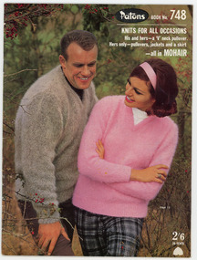
... estate, Margaret Cameron. It was produced by Coats Patons and contains patterns for mens and womens garments knitted in mohair wool. The photographs in this book were taken at 'View Bank', a Welsh mountain pony stud farm owned by Mrs H. ...estate, Margaret Cameron. It was produced by Coats Patons and contains patterns for mens and womens garments knitted in mohair wool. The photographs in this book were taken at 'View Bank', a Welsh mountain pony stud farm owned by Mrs H. ...This book was owned by the late Dr Elizabeth Kerr and was donated to the Museum by the executor of her estate, Margaret Cameron. It was produced by Coats Patons and contains patterns for mens and womens garments knitted in mohair wool. The photographs in this book were taken at 'View Bank', a Welsh mountain pony stud farm owned by Mrs H. Bartramat Heidelberg, Vic.,Patons / BOOK No. 748 / KNITS FOR ALL OCCASIONS / His and hers - a 'V' neck pullover. / Hers only - pullovers, jackets and a skirt / - all in MOHAIR / 2'6 / 25 CENTSknitting handicrafts - history, coats patons (australia) limited, knitting, handicrafts - history -
 Whitehorse Historical Society Inc.
Document, Particulars of Land Boom Companies
... Whitehorse Historical Society Inc. 2-10 Deep Creek Road Mitcham melbourne land subdivision city investment and finance co ltd standard property investment co ltd freehold investment and banking company of australia ltd commercial finance and property pty ltd imperial finance and share company east suburban property investment company bay and mountain views company limited east mitcham brick co ltd imperial banking company mitcham brick and pottery co ltd davies matthew henry sir morton thomas richards burrowes. lachal gustave dow john lamont stamp richard bulmer fink theodore munro & baillieu mendell george fuller arthur j taylor land discount and mortgage bank limited blackburn township estate co ltd springfield estate co ltd royal land co ltd gascoigne investment co ltd tunstall brick and pottery company Research into Land Boom Companies by Keith Patterson Research into Land Boom Companies by Keith Patterson Particulars of Land Boom Companies Document Document ...Research into Land Boom Companies by Keith PattersonResearch into Land Boom Companies by Keith PattersonResearch into Land Boom Companies by Keith Pattersonland subdivision, city investment and finance co ltd, standard property investment co ltd, freehold investment and banking company of australia ltd, commercial finance and property pty ltd, imperial finance and share company, east suburban property investment company, bay and mountain views company limited, east mitcham brick co ltd, imperial banking company, mitcham brick and pottery co ltd, davies, matthew henry, sir, morton, thomas richards burrowes., lachal, gustave, dow, john lamont, stamp, richard, bulmer, fink, theodore, munro & baillieu, mendell, george, fuller, arthur j, taylor, land discount and mortgage bank limited, blackburn township estate co ltd, springfield estate co ltd, royal land co ltd, gascoigne investment co ltd, tunstall brick and pottery company -
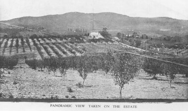 Ringwood and District Historical Society
Photograph, Panoramic view of Heathmont Station Estate. c1925
... View overlooking Martell's orchard, Heathmont, 1925". Taken from corner Canterbury Rd. and Balfour Ave. looking south. Dandenong Creek just beyond house. Washusen Rd. on right. House in middle range, mountains in background. Photograph appears to be reproduced from subdivisional brochure. Note inserted in sleeve reads, "It has been pointed out that the mountains are to the east and the view is looking south. This therefore is not a 'straight' photograph. House still exists in Eden Avenue at October, 1996". Black and white photograph (2 copies) Panoramic view of Heathmont Station Estate ...Black and white photograph (2 copies) Typed below one photograph: "View overlooking Martell's orchard, Heathmont, 1925". Taken from corner Canterbury Rd. and Balfour Ave. looking south. Dandenong Creek just beyond house. Washusen Rd. on right. House in middle range, mountains in background. Photograph appears to be reproduced from subdivisional brochure. Note inserted in sleeve reads, "It has been pointed out that the mountains are to the east and the view is looking south. This therefore is not a 'straight' photograph. House still exists in Eden Avenue at October, 1996". -
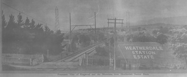 Ringwood and District Historical Society
Photograph, Panoramic view of Ringwood and the Mountains, from Heatherdale Station Estate. 1924
... Black and white photograph (2 copies) Panoramic view of Ringwood and the Mountains, from Heatherdale Station Estate. 1924. ...Black and white photograph (2 copies)Typed below one photograph on mounting sheet, "View from where Heatherdale railway station is now, looking towards Ringwood - 2/2/1924." Typed on back of other photograph: "Between Heatherdale Rd. and Madden St., sold 2nd Feb. 1924. J.B. McAlpin - agent."