Showing 74 items matching "murray river development"
-
 Wodonga & District Historical Society Inc
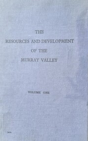
Book - The Resources and Development of the Murray Valley - Volume 1
... Murray River Development...Murray River Development Murray Basin Murray River Resources This report by the Murray Valley Resources Survey Committee is a detailed analysis of Importance and future the Murray River Valley and Basin for the economic development of Australia. ...This report by the Murray Valley Resources Survey Committee is a detailed analysis of Importance and future the Murray River Valley and Basin for the economic development of Australia. It includes a lengthy Foreword written by Prime Minister, Robert Menzies. A map of Australia with the Murray Valley River and Basin shaded in green, and a fold-out detailed map of the Murray River are featured.A small publication in a bound blue cover with black text. This report by the Murray Valley Resources Survey Committee is a detailed analysis of Importance and future the Murray River Valley and Basin for the economic development of Australia. It includes a lengthy Foreword written by Prime Minister, Robert Menzies. A map of Australia with the Murray Valley River and Basin shaded in green, and a fold-out detailed map of the Murray River are featured.murray river development, murray basin, murray river resources -
 Port of Echuca
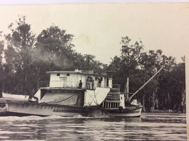
Black and white rectangular photograph, 1950?
... river. If this photograph was taken in 1950, that would have been well before the development of the Tourism Industry in the Murray Darling area. ...murray The paddle steamer P. S Pevensy appears to still be a working steamer in this photograph. The boat seems a bit dishevelled and the workers are doing repairs on her, while she is still steaming up the river. If this photograph was taken in 1950, that would have been well before the development ...The paddle steamer P. S Pevensy appears to still be a working steamer in this photograph. The boat seems a bit dishevelled and the workers are doing repairs on her, while she is still steaming up the river. If this photograph was taken in 1950, that would have been well before the development of the Tourism Industry in the Murray Darling area. This would explain the number of workers and the fact that they were doing maintenance while the Paddle Steamer was still working. She does not appear to be towing a barge, but a large tarpaulin could be covering a load for transport. This picture holds significance because it shows a paddle steamer in use before the Tourism Industry had developed in the Murray Darling region. The paddle steamer which now carries passengers every day has been renovated to cater for passengers cruising up and down the river. Here is this photograph the P.S Pevensy looks a bit dishevelled and untidy.This is a black and white rectangular photograph of the P.S Pevensey. Four people can be seen painting the wall of the cabins on the upper deck. A person can also be seen kneeling on the back deck working on something lying on the back deck. A wooden boat is nearby, also on the back deck. The boat is steaming and appears to be moving upstream. There is along pole at a 45 degree angle attached to the very front of the paddle steamer.On the front of the photograph written on the paddle steamer can't be seen the words "PEVENSEY. Melbourne." Written on the back of the photograph in lead pencil " M4414-17. K4". p.s pevensey, paddle steamers -
 Port of Echuca
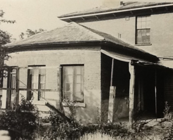
Photograph - Black and white photograph, Late 1970s
... development. It was originally built by Henry Hopwood, the European founder of Echuca, in 1859. Hopwood built the hotel to provide accommodation to people using his punts across the Campaspe and Murray rivers that area central to the landscape of the Port. ...Relates to a series of 5 photos:P000094-P000098 of the front of the Bridge Hotel on the corner of Murray esplanade and Hopwood gardens. These photos, taken about 1976, were before the Port Restoration Scheme renovated the hotel. The Bridge Hotel was built by Henry Hopwood in 1858. This and the Bond Store were Echuca's first 2 brick buildings. Named from Hopwood's nearby pontoon bridge. The building was bought be The Council in 1970. Restored and reopened in 1975.The Bridge Hotel is an important part of Echuca's settlement and development. It was originally built by Henry Hopwood, the European founder of Echuca, in 1859. Hopwood built the hotel to provide accommodation to people using his punts across the Campaspe and Murray rivers that area central to the landscape of the Port. The hotel was situated on the land between both rivers and punts and provided for a variety of levels of accommodation from grand rooms to very basic rooms. At the time of the photos the hotel was 120 years old and became an important part of the Port of Echuca tourism. Black and white photograph of the Bridge Hotel , showing western wing before restoration.Stamped on the reverse "Gazemore Studio, D. G. Gay, 18 Frances Street Echuca 3625.bridge hotel, echcua, port restoration scheme, bridge hotel restoration, echuca -
 Port of Echuca
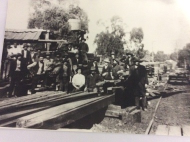
Black and white photograph
... Murray River in Echuca east where the Banyule State forest is now located. A tramway ran out to it from the main rail line near the iron bridge. Macintoshes Sawmill was one of the largest in the area. (Ref. Clare Jackson. ) Macintoshes sawmill was set up by James Macintosh in 1868 in Echuca East. His sawmill prospered and in 1878 was "equal to five normal sawmills" (Ref; Coulson, Helen, "Echuca Moama On the Murray." P.158) He also owned 2 paddle steamers and 8 barges. The Macintosh Family contributed substantially to the development ...Macintosh's sawmill was on the banks of the Murray River in Echuca east where the Banyule State forest is now located. A tramway ran out to it from the main rail line near the iron bridge. Macintoshes Sawmill was one of the largest in the area. (Ref. Clare Jackson. )Macintoshes sawmill was set up by James Macintosh in 1868 in Echuca East. His sawmill prospered and in 1878 was "equal to five normal sawmills" (Ref; Coulson, Helen, "Echuca Moama On the Murray." P.158) He also owned 2 paddle steamers and 8 barges. The Macintosh Family contributed substantially to the development of Echuca East, but by 1901 the Family was in severe debt and were forced to sell the sawmill to the Nicholas Family.A black and white photograph of a large group of men outside a sawmill, reputed to be Macintoshes Sawmill in Echuca East.On the back of the photograph written in pencil are the words "Believed to be workmen at McIntosh's mill (Charlie Dowell says)macintosh's sawmill, sawmill industry, echuca east, banyule state forest, macintosh james, dowell, charlie, logging industry, jackson, clare -
 Orbost & District Historical Society
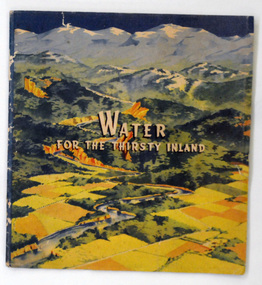
book, Water For the Thirsty Inland, 1945
... River waters to the Murrumbidgee. In 1950 The Murrumbidgee Valley Water Users Association and the League established the Murray-Murrumbidgee Development Committee to ensure the Snowy Scheme was completed....River waters to the Murrumbidgee. In 1950 The Murrumbidgee Valley Water Users Association and the League established the Murray-Murrumbidgee Development Committee to ensure the Snowy Scheme was completed. ...Water For the Thirsty Inland was published by The Murrumbidgee Valley Water Users Association as a case for diversion of part of the Snowy River waters to the Murrumbidgee. In 1950 The Murrumbidgee Valley Water Users Association and the League established the Murray-Murrumbidgee Development Committee to ensure the Snowy Scheme was completed.This book is a significant research tool for the history of the diversion of the Snowy River.A 44 pp book, titled Water For The Thirsty Inland. On the front cover is a coloured print of a painting of a river (Snowy River?) from the mountains to the flats. The text of the title is white with a black shadow. The book contains b/w photographs and the print is black and green.Some pencilled notes on back.snowy-river murrumbidgee-valley-water-users' irrigation -
 Federation University Historical Collection
Report, Echuca Moama Tourism Planning and Development Strategy, c1996
... Barker Library (top floor) Mount Helen goldfields victorian tourism industry tourism alumni echuca moama hopwood's ferry murray river goulburn river campaspe river gaming Report compiled by three students of 'Tourism Planning and Development' at Ballarat University College (later Federation University Australia). ...Report compiled by three students of 'Tourism Planning and Development' at Ballarat University College (later Federation University Australia).victorian tourism industry, tourism, alumni, echuca, moama, hopwood's ferry, murray river, goulburn river, campaspe river, gaming -
 Federation University Historical Collection
Report, Echuca Moama Tourism Planning and Development Strategy, 1993, 06/1993
... Barker Library (top floor) Mount Helen goldfields victorian tourism industry tourism alumni echuca moama hopwood's ferry murray river goulburn river campaspe river gaming port of echuca Report compiled by four students of 'Tourism Planning and Development' at Ballarat University College (later Federation University Australia). ...Report compiled by four students of 'Tourism Planning and Development' at Ballarat University College (later Federation University Australia).victorian tourism industry, tourism, alumni, echuca, moama, hopwood's ferry, murray river, goulburn river, campaspe river, gaming, port of echuca -
 Charlton Golden Grains Museum Inc
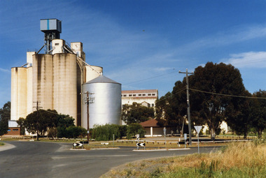
Photograph, Charlton Shire, Charlton Flour Mill, c.1987
... development of Charlton and the grain industry of the surrounding district. The foundation for the mill's presence was laid in 1919 when Messrs Noske Bros. Pty. Ltd., already owning mills in Horsham, Nhill, and Murray Bridge, acquired G. H. Foreman’s Mill located by the Avoca River...development of Charlton and the grain industry of the surrounding district. The foundation for the mill's presence was laid in 1919 when Messrs Noske Bros. Pty. Ltd., already owning mills in Horsham, Nhill, and Murray Bridge, acquired G. H. Foreman’s Mill located by the Avoca River ...A previous mill had operated in Charlton by Mr. W.E. Foreman on the banks of the Avoca River and was acquired in 1919 by Noske Bros. The present Flour Mill was built by Noske Bros and opened in May 1927. It was taken over by the Grain Elevator Board in the 1970s. Noske's Flour Mill, with its commanding presence and towering silos, has long **dominated the Charlton skyline** and remains a significant landmark, even though it no longer mills flour. The mill's history is deeply intertwined with the development of Charlton and the grain industry of the surrounding district. The foundation for the mill's presence was laid in 1919 when Messrs Noske Bros. Pty. Ltd., already owning mills in Horsham, Nhill, and Murray Bridge, acquired G. H. Foreman’s Mill located by the Avoca River. The founder, **T. J. Noske**, was an early pioneer of flour exporting, expanding his milling business after unexpectedly acquiring the Horsham mill. ### A State-of-the-Art Operation The original mill by the river operated until August 1926 before being closed and dismantled. Plans were well underway for a **new, state-of-the-art mill** to be located at the former Cobb and Co site. In 1927, the new mill began operation. It was one of the largest in the state, boasting a capacity of three tons of flour per hour, a 250 h.p. diesel engine, and three initial silos. The mill quickly gained a reputation for **excellence** for both its design and its flour, which was sold successfully in local and overseas markets. ### Periods of Expansion and Trial The mill continued to grow, reflecting the importance of the local agricultural industry. Between 1940 and 1941, **nine new silos** were built, adding bulk receival points. In the record-breaking 1968 season, the mill received a colossal wheat intake of **695,000 bushels**. However, the mill also faced setbacks. On January 21, 1949, disaster struck when a **large fire** erupted in the storage shed, which contained 500 tons of bagged flour ready for export and new flour bags. The blaze was so intense that smoke was visible as far away as Wycheproof, and it threatened to destroy the entire mill. Thanks to the monumental efforts of the Charlton, St. Arnaud, Wycheproof, and Wedderburn Brigades, who ran the main pump almost continuously for 26 hours, the damage was contained, though the estimated loss was a substantial £60,000. ### Transformation of the Site At its peak, the mill was a major employer, providing work for approximately 65–70 men. But after over 45 years of operation, flour production at the mill ceased on October 25, 1973. Noske Industries Ltd. sought to adapt, converting the operation to a less successful stock feed production centre. In 1977, the **Grain Elevators Board** took over the site as a grain receival depot, building a large elevator tower that surpassed the height of the original buildings. The site eventually returned to private hands and, since 2000, has been owned and operated as a primary grain receival site for **GrainCorp**, cementing its continued, vital role in Charlton's agricultural life. Colour photograph of Charlton Flour Mill and silos. Intersection of Kaye & Davies Streets in the foreground. One large silver silo and three taller greyish concrete silos to the left. Three other cream coloured silos behind. There are pipes and sheds on top of the silos. There is a cream single story building to the right of the silver silo and a multi-storey building behind with eight window in the upper level. There is a small red brick building on the far left of the photo.w.e. foreman, noske bros, flour mill charlton, business, industry -
 Charlton Golden Grains Museum Inc
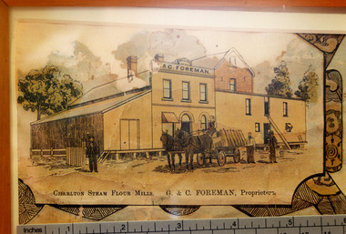
Photograph - Lithograph, Rider & Mercer, Views of Charlton
... development of Charlton and the grain industry of the surrounding district. The foundation for the mill's presence was laid in 1919 when Messrs Noske Bros. Pty. Ltd., already owning mills in Horsham, Nhill, and Murray Bridge, acquired G. H. Foreman’s Mill located by the Avoca River...development of Charlton and the grain industry of the surrounding district. The foundation for the mill's presence was laid in 1919 when Messrs Noske Bros. Pty. Ltd., already owning mills in Horsham, Nhill, and Murray Bridge, acquired G. H. Foreman’s Mill located by the Avoca River ...Close up photograph of part of the Charlton Lithograph showing the Charlton Steam Power Flour Mill of G & C Foreman. Located in on the bank of the Avoca river. The mill owners attempted to dam the river during the 1870s. The mill was built in 1876 as recorded by the local traveling correspondent . Foreman's flour mill established 1876 at the west end of High Street. Sold to Norske in 1925. Replaced by Noske's Flour Mill on Kays Street in 1927. Noske's Flour Mill, with its commanding presence and towering silos, has long **dominated the Charlton skyline** and remains a significant landmark, even though it no longer mills flour. The mill's history is deeply intertwined with the development of Charlton and the grain industry of the surrounding district. The foundation for the mill's presence was laid in 1919 when Messrs Noske Bros. Pty. Ltd., already owning mills in Horsham, Nhill, and Murray Bridge, acquired G. H. Foreman’s Mill located by the Avoca River. The founder, **T. J. Noske**, was an early pioneer of flour exporting, expanding his milling business after unexpectedly acquiring the Horsham mill. ### A State-of-the-Art Operation The original mill by the river operated until August 1926 before being closed and dismantled. Plans were well underway for a **new, state-of-the-art mill** to be located at the former Cobb and Co site. In 1927, the new mill began operation. It was one of the largest in the state, boasting a capacity of three tons of flour per hour, a 250 h.p. diesel engine, and three initial silos. The mill quickly gained a reputation for **excellence** for both its design and its flour, which was sold successfully in local and overseas markets. ### Periods of Expansion and Trial The mill continued to grow, reflecting the importance of the local agricultural industry. Between 1940 and 1941, **nine new silos** were built, adding bulk receival points. In the record-breaking 1968 season, the mill received a colossal wheat intake of **695,000 bushels**. However, the mill also faced setbacks. On January 21, 1949, disaster struck when a **large fire** erupted in the storage shed, which contained 500 tons of bagged flour ready for export and new flour bags. The blaze was so intense that smoke was visible as far away as Wycheproof, and it threatened to destroy the entire mill. Thanks to the monumental efforts of the Charlton, St. Arnaud, Wycheproof, and Wedderburn Brigades, who ran the main pump almost continuously for 26 hours, the damage was contained, though the estimated loss was a substantial £60,000. ### Transformation of the Site At its peak, the mill was a major employer, providing work for approximately 65–70 men. But after over 45 years of operation, flour production at the mill ceased on October 25, 1973. Noske Industries Ltd. sought to adapt, converting the operation to a less successful stock feed production centre. In 1977, the **Grain Elevators Board** took over the site as a grain receival depot, building a large elevator tower that surpassed the height of the original buildings. The site eventually returned to private hands and, since 2000, has been owned and operated as a primary grain receival site for **GrainCorp**, cementing its continued, vital role in Charlton's agricultural life.Colour photo taken of a small portion of the Charlton Lithograph. Showing the Charlton Steam Flour Mill of G. C. Foreman.Charlton Steam Flour Mills. G & C Foreman proprietors.lithograph, business, industry, charlton, flour mill, noske bros, foreman -
 Charlton Golden Grains Museum Inc
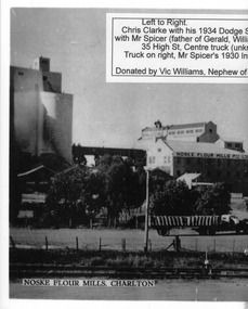
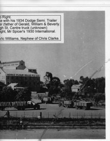
Photograph, c.1948
... development of Charlton and the grain industry of the surrounding district. The foundation for the mill's presence was laid in 1919 when Messrs Noske Bros. Pty. Ltd., already owning mills in Horsham, Nhill, and Murray Bridge, acquired G. H. Foreman’s Mill located by the Avoca River...development of Charlton and the grain industry of the surrounding district. The foundation for the mill's presence was laid in 1919 when Messrs Noske Bros. Pty. Ltd., already owning mills in Horsham, Nhill, and Murray Bridge, acquired G. H. Foreman’s Mill located by the Avoca River ...Black and white photo copied and enlarged from small photo which was part of a set produced in c.1948. Chris Clarke with his 1934 Dodge semi trailer and W Spicer in his 1930 International truck line up to unload wheat at Noske's mill. Noskes flour mill built in 1927 with extra silos added in 1940's.Photo enlarged by Vic Williams of Bendigo nephew of Chris Clarke transport driver. Noske's Flour Mill, with its commanding presence and towering silos, has long **dominated the Charlton skyline** and remains a significant landmark, even though it no longer mills flour. The mill's history is deeply intertwined with the development of Charlton and the grain industry of the surrounding district. The foundation for the mill's presence was laid in 1919 when Messrs Noske Bros. Pty. Ltd., already owning mills in Horsham, Nhill, and Murray Bridge, acquired G. H. Foreman’s Mill located by the Avoca River. The founder, **T. J. Noske**, was an early pioneer of flour exporting, expanding his milling business after unexpectedly acquiring the Horsham mill. ### A State-of-the-Art Operation The original mill by the river operated until August 1926 before being closed and dismantled. Plans were well underway for a **new, state-of-the-art mill** to be located at the former Cobb and Co site. In 1927, the new mill began operation. It was one of the largest in the state, boasting a capacity of three tons of flour per hour, a 250 h.p. diesel engine, and three initial silos. The mill quickly gained a reputation for **excellence** for both its design and its flour, which was sold successfully in local and overseas markets. ### Periods of Expansion and Trial The mill continued to grow, reflecting the importance of the local agricultural industry. Between 1940 and 1941, **nine new silos** were built, adding bulk receival points. In the record-breaking 1968 season, the mill received a colossal wheat intake of **695,000 bushels**. However, the mill also faced setbacks. On January 21, 1949, disaster struck when a **large fire** erupted in the storage shed, which contained 500 tons of bagged flour ready for export and new flour bags. The blaze was so intense that smoke was visible as far away as Wycheproof, and it threatened to destroy the entire mill. Thanks to the monumental efforts of the Charlton, St. Arnaud, Wycheproof, and Wedderburn Brigades, who ran the main pump almost continuously for 26 hours, the damage was contained, though the estimated loss was a substantial £60,000. ### Transformation of the Site At its peak, the mill was a major employer, providing work for approximately 65–70 men. But after over 45 years of operation, flour production at the mill ceased on October 25, 1973. Noske Industries Ltd. sought to adapt, converting the operation to a less successful stock feed production centre. In 1977, the **Grain Elevators Board** took over the site as a grain receival depot, building a large elevator tower that surpassed the height of the original buildings. The site eventually returned to private hands and, since 2000, has been owned and operated as a primary grain receival site for **GrainCorp**, cementing its continued, vital role in Charlton's agricultural life.Black and white photo copied and enlarged from small photo.charlton, flour mill, noske's, noske bros -
 Charlton Golden Grains Museum Inc
Photograph, c.1948
... development of Charlton and the grain industry of the surrounding district. The foundation for the mill's presence was laid in 1919 when Messrs Noske Bros. Pty. Ltd., already owning mills in Horsham, Nhill, and Murray Bridge, acquired G. H. Foreman’s Mill located by the Avoca River...development of Charlton and the grain industry of the surrounding district. The foundation for the mill's presence was laid in 1919 when Messrs Noske Bros. Pty. Ltd., already owning mills in Horsham, Nhill, and Murray Bridge, acquired G. H. Foreman’s Mill located by the Avoca River ...Black and white photo copied and enlarged from small photo which was part of a set produced in c.1948. Chris Clarke with his 1934 Dodge semi trailer and W Spicer in his 1930 International truck line up to unload wheat at Noske's mill. Noskes flour mill built in 1927 with extra silos added in 1940's. Photo enlarged by Vic Williams of Bendigo nephew of Chris Clarke transport driver. Noske's Flour Mill, with its commanding presence and towering silos, has long **dominated the Charlton skyline** and remains a significant landmark, even though it no longer mills flour. The mill's history is deeply intertwined with the development of Charlton and the grain industry of the surrounding district. The foundation for the mill's presence was laid in 1919 when Messrs Noske Bros. Pty. Ltd., already owning mills in Horsham, Nhill, and Murray Bridge, acquired G. H. Foreman’s Mill located by the Avoca River. The founder, **T. J. Noske**, was an early pioneer of flour exporting, expanding his milling business after unexpectedly acquiring the Horsham mill. ### A State-of-the-Art Operation The original mill by the river operated until August 1926 before being closed and dismantled. Plans were well underway for a **new, state-of-the-art mill** to be located at the former Cobb and Co site. In 1927, the new mill began operation. It was one of the largest in the state, boasting a capacity of three tons of flour per hour, a 250 h.p. diesel engine, and three initial silos. The mill quickly gained a reputation for **excellence** for both its design and its flour, which was sold successfully in local and overseas markets. ### Periods of Expansion and Trial The mill continued to grow, reflecting the importance of the local agricultural industry. Between 1940 and 1941, **nine new silos** were built, adding bulk receival points. In the record-breaking 1968 season, the mill received a colossal wheat intake of **695,000 bushels**. However, the mill also faced setbacks. On January 21, 1949, disaster struck when a **large fire** erupted in the storage shed, which contained 500 tons of bagged flour ready for export and new flour bags. The blaze was so intense that smoke was visible as far away as Wycheproof, and it threatened to destroy the entire mill. Thanks to the monumental efforts of the Charlton, St. Arnaud, Wycheproof, and Wedderburn Brigades, who ran the main pump almost continuously for 26 hours, the damage was contained, though the estimated loss was a substantial £60,000. ### Transformation of the Site At its peak, the mill was a major employer, providing work for approximately 65–70 men. But after over 45 years of operation, flour production at the mill ceased on October 25, 1973. Noske Industries Ltd. sought to adapt, converting the operation to a less successful stock feed production centre. In 1977, the **Grain Elevators Board** took over the site as a grain receival depot, building a large elevator tower that surpassed the height of the original buildings. The site eventually returned to private hands and, since 2000, has been owned and operated as a primary grain receival site for **GrainCorp**, cementing its continued, vital role in Charlton's agricultural life.Black and white photocharton, business, noske bros, flour mill -
 Charlton Golden Grains Museum Inc
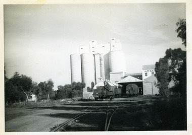
Photograph, c.1960
... development of Charlton and the grain industry of the surrounding district. The foundation for the mill's presence was laid in 1919 when Messrs Noske Bros. Pty. Ltd., already owning mills in Horsham, Nhill, and Murray Bridge, acquired G. H. Foreman’s Mill located by the Avoca River...development of Charlton and the grain industry of the surrounding district. The foundation for the mill's presence was laid in 1919 when Messrs Noske Bros. Pty. Ltd., already owning mills in Horsham, Nhill, and Murray Bridge, acquired G. H. Foreman’s Mill located by the Avoca River ...Noske's mill in mid 1960s. Noske's Flour Mill, with its commanding presence and towering silos, has long **dominated the Charlton skyline** and remains a significant landmark, even though it no longer mills flour. The mill's history is deeply intertwined with the development of Charlton and the grain industry of the surrounding district. The foundation for the mill's presence was laid in 1919 when Messrs Noske Bros. Pty. Ltd., already owning mills in Horsham, Nhill, and Murray Bridge, acquired G. H. Foreman’s Mill located by the Avoca River. The founder, **T. J. Noske**, was an early pioneer of flour exporting, expanding his milling business after unexpectedly acquiring the Horsham mill. ### A State-of-the-Art Operation The original mill by the river operated until August 1926 before being closed and dismantled. Plans were well underway for a **new, state-of-the-art mill** to be located at the former Cobb and Co site. In 1927, the new mill began operation. It was one of the largest in the state, boasting a capacity of three tons of flour per hour, a 250 h.p. diesel engine, and three initial silos. The mill quickly gained a reputation for **excellence** for both its design and its flour, which was sold successfully in local and overseas markets. ### Periods of Expansion and Trial The mill continued to grow, reflecting the importance of the local agricultural industry. Between 1940 and 1941, **nine new silos** were built, adding bulk receival points. In the record-breaking 1968 season, the mill received a colossal wheat intake of **695,000 bushels**. However, the mill also faced setbacks. On January 21, 1949, disaster struck when a **large fire** erupted in the storage shed, which contained 500 tons of bagged flour ready for export and new flour bags. The blaze was so intense that smoke was visible as far away as Wycheproof, and it threatened to destroy the entire mill. Thanks to the monumental efforts of the Charlton, St. Arnaud, Wycheproof, and Wedderburn Brigades, who ran the main pump almost continuously for 26 hours, the damage was contained, though the estimated loss was a substantial £60,000. ### Transformation of the Site At its peak, the mill was a major employer, providing work for approximately 65–70 men. But after over 45 years of operation, flour production at the mill ceased on October 25, 1973. Noske Industries Ltd. sought to adapt, converting the operation to a less successful stock feed production centre. In 1977, the **Grain Elevators Board** took over the site as a grain receival depot, building a large elevator tower that surpassed the height of the original buildings. The site eventually returned to private hands and, since 2000, has been owned and operated as a primary grain receival site for **GrainCorp**, cementing its continued, vital role in Charlton's agricultural life.Black and white photograph with white border.charlton, business, noske's, flour mill -
 Charlton Golden Grains Museum Inc
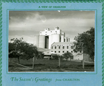
Postcard, A view of Charlton. The seasons greeting from Charlton, c.1946
... development of Charlton and the grain industry of the surrounding district. The foundation for the mill's presence was laid in 1919 when Messrs Noske Bros. Pty. Ltd., already owning mills in Horsham, Nhill, and Murray Bridge, acquired G. H. Foreman’s Mill located by the Avoca River...development of Charlton and the grain industry of the surrounding district. The foundation for the mill's presence was laid in 1919 when Messrs Noske Bros. Pty. Ltd., already owning mills in Horsham, Nhill, and Murray Bridge, acquired G. H. Foreman’s Mill located by the Avoca River ...Eight silos added in 1940s. Noske's Flour Mill, with its commanding presence and towering silos, has long **dominated the Charlton skyline** and remains a significant landmark, even though it no longer mills flour. The mill's history is deeply intertwined with the development of Charlton and the grain industry of the surrounding district. The foundation for the mill's presence was laid in 1919 when Messrs Noske Bros. Pty. Ltd., already owning mills in Horsham, Nhill, and Murray Bridge, acquired G. H. Foreman’s Mill located by the Avoca River. The founder, **T. J. Noske**, was an early pioneer of flour exporting, expanding his milling business after unexpectedly acquiring the Horsham mill. ### A State-of-the-Art Operation The original mill by the river operated until August 1926 before being closed and dismantled. Plans were well underway for a **new, state-of-the-art mill** to be located at the former Cobb and Co site. In 1927, the new mill began operation. It was one of the largest in the state, boasting a capacity of three tons of flour per hour, a 250 h.p. diesel engine, and three initial silos. The mill quickly gained a reputation for **excellence** for both its design and its flour, which was sold successfully in local and overseas markets. ### Periods of Expansion and Trial The mill continued to grow, reflecting the importance of the local agricultural industry. Between 1940 and 1941, **nine new silos** were built, adding bulk receival points. In the record-breaking 1968 season, the mill received a colossal wheat intake of **695,000 bushels**. However, the mill also faced setbacks. On January 21, 1949, disaster struck when a **large fire** erupted in the storage shed, which contained 500 tons of bagged flour ready for export and new flour bags. The blaze was so intense that smoke was visible as far away as Wycheproof, and it threatened to destroy the entire mill. Thanks to the monumental efforts of the Charlton, St. Arnaud, Wycheproof, and Wedderburn Brigades, who ran the main pump almost continuously for 26 hours, the damage was contained, though the estimated loss was a substantial £60,000. ### Transformation of the Site At its peak, the mill was a major employer, providing work for approximately 65–70 men. But after over 45 years of operation, flour production at the mill ceased on October 25, 1973. Noske Industries Ltd. sought to adapt, converting the operation to a less successful stock feed production centre. In 1977, the **Grain Elevators Board** took over the site as a grain receival depot, building a large elevator tower that surpassed the height of the original buildings. The site eventually returned to private hands and, since 2000, has been owned and operated as a primary grain receival site for **GrainCorp**, cementing its continued, vital role in Charlton's agricultural life.Large landscape black and white photo set on a blue card backing. The card has a green holly leaf pattern embossed on the edge.A view of Charlton. The Season's Greetings from Charlton.charlton, noske bros, noske's, flour mill -
 Tatura Irrigation & Wartime Camps Museum
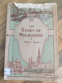
Book, The Story of Melbourne, 1934
... murray Written as an accurate history of the foundation and development of City of Melbourne. Foreword by Lord Mayor of Melbourne, Sir. H Gengoult-Smith the story of melbourne kenyon af stewart f tatura victorian history sir gengoult-smith Inscription on first page "R. McPherson St Kilda" Cream, pale green cover. Brown lettering. Sketches of early discovery scene and Yarra river ...Cream, pale green cover. Brown lettering. Sketches of early discovery scene and Yarra river, Flinders Street, Station and St. Paul's Cathedralthe story of melbourne, kenyon af, stewart f, tatura, victorian history, sir gengoult-smith -
Tatura Irrigation & Wartime Camps Museum
Book, Irrigation and Water Supply Development in Victoria, 1954
... murray History of irrigaton in Victoria. Reference to Eildon Reservoir, Goulburn Weir, Waranga Reservoir, River Murray irrigation systems irrigation water supply goulburn river books history local Buff and blue covered book, showing farmhouse, dairy cattle on front cover, cattle, trees and channel on back Irrigation and Water Supply Development in Victoria Book ...History of irrigaton in Victoria. Reference to Eildon Reservoir, Goulburn Weir, Waranga Reservoir, River Murray irrigation systemsBuff and blue covered book, showing farmhouse, dairy cattle on front cover, cattle, trees and channel on backirrigation, water supply, goulburn river, books, history, local -
 Puffing Billy Railway
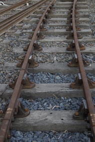
Double Headed Rail, circa 1872 - 1883
... Murray River Railway. George Christian Derbyshire, the first Engineer-in-Chair of the Victorian Railways was responsible for the design and construction of the works. No new lines were built in Victoria using double-headed rail after 1870. The siding was disconnected from the main line in 1988. The Ravenswood Railway Siding demonstrates the original 1856 philosophy of the Victorian Railways to adopt British permanent way technology. The siding demonstrates significant aspects in the development...Murray River Railway. George Christian Derbyshire, the first Engineer-in-Chair of the Victorian Railways was responsible for the design and construction of the works. No new lines were built in Victoria using double-headed rail after 1870. The siding was disconnected from the main line in 1988. The Ravenswood Railway Siding demonstrates the original 1856 philosophy of the Victorian Railways to adopt British permanent way technology. The siding demonstrates significant aspects in the development ...Double Headed Rail from Ravenswood Station Siding which was dismantled circa 1987 the two rails were stored for a time at Maldon before being donated to Puffing Billy Museum Bearing makers marks of Wilson & Cammell - Dronfield- Steel works Wilson & Cammell made Steel rails at their Dronfield Steel Works, in Dronfield, North East Derbyshire, England from 1872 - 1883 Double-headed rail In late 1830s Britain, railway lines had a vast range of different patterns. One of the earliest lines to use double-headed rail was the London and Birmingham Railway, which had offered a prize for the best design. This rail was supported by chairs and the head and foot of the rail had the same profile. The supposed advantage was that, when the head became worn, the rail could be turned over and re-used. In practice, this form of recycling was not very successful as the chair caused dents in the lower surface, and double-headed rail evolved into bullhead rail in which the head was more substantial than the foot. Info from Wikipedia - Rail Profile https://en.wikipedia.org/wiki/Rail_profile The first records of double headed rail being used In Victoria by Victorian Railways was in 1859, the rails, chairs, oak and trenails were imported from UK. After the 1870’s the Victorian Railways went over to using flat bottom rails, but they still needed replacement double headed rail for lines already laid and this continued up to at least 1883 Wilson & Cammell - Dronfield- Steel works Wilson & Cammell made Steel rails at their Dronfield Steel Works, in Dronfield England from 1872 - 1883 Mount Alexander & Murray River Railway The Melbourne, Mount Alexander & Murray River Railway Company received parliamentary assent in February 1853 to build Victoria's first inland railway from Melbourne to Williamstown, and Melbourne to Bendigo and Echuca. Construction commenced in January 1854 with work on a pier at Williamstown but lack of funds slowed progress, eventually prompting the company to sell out to the government. The 100-mile (162 km) section to Bendigo opened in October 1862. Its cost of £35,000 per mile made it the most expensive railway ever built in Australia. In 1864, the line was extended to Echuca, tapping into the booming Murray-Darling paddlesteamer trade. info from Museums Victoria - Victorian Railways https://museumsvictoria.com.au/railways/theme.aspx?lvl=3&IRN=450&gall=456 1863 Ravenswood Station open on the 1st Feb 1863 Victorian Railways - purchased and imported the Rail and Chairs from Raleigh, Dalgleish, White and Co. London Importation of railway plant : abstract of a return to an order of the Legislative Assembly dated 27th June 1860 for - Copies of the advertisements calling for tenders, the names of the tenderers and the accounts and correspondence with Mr Brunel relating thereto GP V 1859/60 no. C 15 http://www.parliament.vic.gov.au/papers/govpub/VPARL1859-60NoC15.pdf Report from the Select Committee upon the Importation of Railway Plant : together with proceedings of the Committee, minutes of evidence and appendix GP V 1859/60 no. D 38 (2.9 MB) http://www.parliament.vic.gov.au/papers/govpub/VPARL1859-60NoD38.pdf Ravenswood Siding When the Victorian Railways were established in 1856 they adopted one of the popular British permanent way standards - heavy 80lb (36.3kg) double-headed rail held up right in cast iron chairs attached to transverse timber sleepers by wooden pegs called trenails. The Ravenswood Railway siding was constructed in 1862 with 12 feet wrought iron double-head rail held in cast iron chairs with Ransom and May patent compressed keys. Trenails held the chairs to the sleepers and the joints were secured in joint chairs. Joints were subsequently joined using fish plates. It formed part of the Melbourne to Echuca rail line, initially known as the Melbourne, Mt Alexander and Murray River Railway. George Christian Derbyshire, the first Engineer-in-Chair of the Victorian Railways was responsible for the design and construction of the works. No new lines were built in Victoria using double-headed rail after 1870. The siding was disconnected from the main line in 1988. The Ravenswood Railway Siding demonstrates the original 1856 philosophy of the Victorian Railways to adopt British permanent way technology. The siding demonstrates significant aspects in the development of permanent way technology in England and Victoria over the period from the 1830's to the 1880's. The chairs in the Ravenswood siding are physical evidence of early railway technology rendered obsolete 120 years ago, namely joint chairs at rail joints and trenails to secure the chairs to the sleepers. The double-headed rail demonstrates an important stage in the evolution of British rail technology in the 1830s. The old fish plates, square headed bolts and square nuts demonstrate the success of fishing the rail joins. The Ravenswood siding demonstrates the earliest form of rail joint technology developed in England, and existing in Australia, the joint chair. In part of the siding the sequence of joint and intermediate chairs is consistent with the 1856 specifications, that sequence is rare with the joints secured in joint chairs. The survival of chairs in this sequence is rare and almost certainly demonstrates that they remained in continuous use at the same location from 1862 to 1988. This remnant of the Ravenswood siding has survived 126 years. The siding has proved to be the most significant of extant remnant double-headed sidings in Victoria, containing a rare combination of early permanent way technologies. Construction dates 1862, Info from Ravenswood Railway Siding Victorian Heritage Database Report http://vhd.heritagecouncil.vic.gov.au/places/4693/download-report The remaining section of this siding is significant at the State and National levels in that it demonstrates the use of chaired rail by the Victorian Railways Department for the Trunk Lines and, more particularly, the following stages in the evolution of this long obsolete method of permanent way construction: a) The use of joint chairs and intermediate chairs at regular intervals inferring that the original wrought iron rail lengths were 12 feet, as is known through documentary sources to have been the case. The survival of chairs in this sequence is unique and almost certainly demonstrates that they have remained in continuous use at the same location and in the same sequence from 1862 to 1988 . b) The use of joint chairs and intermediate chairs designed for use with trenails. c) The use of later intermediate chairs designed for use with steel pins and the use of fished joints with steel double head chaired rail, representing a second method of constructing the permanent way using chaired rail technology. info from Ravenswood Siding - Melbourne/Echuca Railway Line - Victorian Heritage Database Report http://vhd.heritagecouncil.vic.gov.au/places/70103/download-report Addition to Citation for Melbourne to EchucaRailway Line 1/10/1990 Double Head Rail The surviving lengths of double head rail with chairs on this railway compare with one surviving similar remnant on the Geelong to Ballarat railway and are representative of permanent way construction techniques applied exclusively to the two trunk railways of the 1860's. In this respect they are rare survivors and may be unique at the national level and of technical importance at the international level to the extent that they enhance contemporary understanding of early railway building technology. Surviving lengths of chaired double head rail survive at Kyneton, Ravenswood and Bendigo on this railway and include a number of different types of cast iron intermediate and joint chairs with hardwood keys and metal pins. The Ravenswood siding is of special significance for the diversity of chair types and for the sequence of chairs recalling rail lengths known to be associated with construction of the line in 1862. Construction of the Railway Tenders closed on 24 March 1858 with no less than 133 tenders being received. A contract was let to Cornish and Bruce for £3,356,937 to commence work on 1 June 1858 and complete the line by 31 July 1861. Cornish and Bruce made quick early progress with the Melbourne to Sunbury section being officially opened on 13 January 1859. The line was officially opened to Bendigo (Sandhurst) on 20 October 1862 by the Governor of Victoria, Sir Henry Barkly. A great banquet was held for 800 guests and this was followed by a grand ball. The extension of the line to Echuca was a relatively simple matter as that part of the line was across plain country without any significant engineering challenges. Tenders were called for the work in 1863 and the work was completed in 1864 by contractors Collier and Barry Apart from the line contractors, other firms directly involved were J Shire law and Co (sleepers), R Fulton, Langlands Brothers and Co, William Crossley (water supply), B Moreland, Langlands Brothers and Co (platelayers lorries), E Chambers (iron pins, traversers), Miller and McQuinstan (luggage vans and steam engines) and various contractors for building works. Info from Engineers Australia Engineering Heritage Victoria Nomination for Recognition under the Engineering Heritage Australia Heritage Recognition Program for the Goldfields Railways - Melbourne , Bendigo & Echuca Railway Page 25 - .2.9.2 Statement from National Trust of Australia (Victoria) Listing number B5323 for Mt Alexander/Murray Valley Rail Line: Page 69 - Theme 3 https://www.engineersaustralia.org.au/portal/system/files/engineering-heritage-australia/nomination-title/Melbourne_%20Bendigo_Echuca%20Railway%20Nomination.pdf The Melbourne, Mount Alexander and Murray River Railway Company was a railway company in Victoria, Australia. It was established on 8 February 1853 to build a railway from Melbourne to Echuca on the Victorian-NSW border and a branch railway to Williamstown. The company struggled to make any progress and on 23 May 1856, the colonial Government took over the Company and it became part of the newly established Department of Railways, part of the Board of Land and Works. The Department of Railways became Victorian Railways in 1859. Construction of the Bendigo line commenced in 1858, but this private consortium also met with financial difficulties when it was unable to raise sufficient funds, and was bought out by the Victorian colonial government. The design work was then taken over by Captain Andrew Clarke, R. E., Surveyor-General of Victoria, with bridge designs completed by Bryson and O'Hara The contract for the first stage of the line from Footscray to Sandhurst (now Bendigo), was let to Cornish and Bruce for £3,356,937.2s.2d ($6.714 million) with work commencing on 1 June 1858. Completion of the permanent way was to be by 31 July 1861 https://en.wikipedia.org/wiki/Melbourne,_Mount_Alexander_and_Murray_River_Railway_Company Victorian Railways - purchased and imported the Rail and Chairs from Raleigh, Dalgleish, White and Co. London Importation of railway plant : abstract of a return to an order of the Legislative Assembly dated 27th June 1860 for - Copies of the advertisements calling for tenders, the names of the tenderers and the accounts and correspondence with Mr Brunel relating thereto GP V 1859/60 no. C 15 http://www.parliament.vic.gov.au/papers/govpub/VPARL1859-60NoC15.pdf Report from the Select Committee upon the Importation of Railway Plant : together with proceedings of the Committee, minutes of evidence and appendix GP V 1859/60 no. D 38 (2.9 MB) http://www.parliament.vic.gov.au/papers/govpub/VPARL1859-60NoD38.pdf Victorian Railways : report of the Board of Land and Works November 1862 GP V 1862/63 no. 21 (2.8 MB) https://www.parliament.vic.gov.au/papers/govpub/VPARL1862-63No21.pdfHistoric - Victorian Railways - Double Headed rail Ravenswood Railway Station and Siding Victorian Heritage Database Reports Victorian Heritage Register VHR H1100 Victorian Heritage Register VHR H1786 National Trust VHR H1100 Mount Alexander and Murray River Rail way Line National Trust2 rail lengths of Double Headed Rail made of Iron makers marks : Wilson & Cammell - Dronfield - Steel and 20 joint chairs with metal rail pins Makers mark Wilson & Cammell - Dronfield - Steel (possible date 187? very hard to read ) puffing billy, double headed rail, wilson & cammell - dronfield - steel works, ravenswood station siding, melbourne to echuca rail line, initially known as the melbourne, mt alexander and murray river railway. -
 Victorian Aboriginal Corporation for Languages
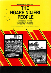
Book, Education Department of South Australia, The Ngarrindjeri people : Aboriginal people of the River Murray, Lakes and Coorong : an Aboriginal studies course for secondary students in Years 8-10, 1990
... river murray...coorong...aboriginal studies...secondary school education...oral history...curriculum development...Victorian Aboriginal Corporation for Languages 33 Saxon Street Brunswick melbourne ngarrindjeri river murray coorong aboriginal studies secondary school education oral history curriculum development maps, b&w illustrations, b&w photographs, oral histories, suggested class activities An Aboriginal studies course detailing the history, culture and life experiences of the original peoples of the areas along the River Murray, Lakes and Coorong. ...An Aboriginal studies course detailing the history, culture and life experiences of the original peoples of the areas along the River Murray, Lakes and Coorong. It is part of the 8-12 Aboriginal studies program developed to meet the needs of students, teachers and Aboriginal people.maps, b&w illustrations, b&w photographs, oral histories, suggested class activitiesngarrindjeri, river murray, coorong, aboriginal studies, secondary school education, oral history, curriculum development -
 Federation University Art Collection
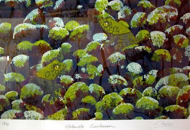
Work on paper - Printmaking - Silkscreen, Lin Onus, 'Walawala Garrkman' by Lin Onus, 2001
... development was his visits to Garmedi (Arnhem Land) starting in 1986. Jack Wunuwun, the Yolngu artist, introduced him into the Murrungun-Djinang clan and gave him permission to use some of traditional images in his paintings. His cultural education on the Aboriginal side was also provided by visits to Cummeragunja with his father, and stories told by his uncle Aaron Briggs, known as 'the old man of the forest' who gave him his Koori name - Burrinja, meaning 'star'. They would sit on the banks of the Murray River...development was his visits to Garmedi (Arnhem Land) starting in 1986. Jack Wunuwun, the Yolngu artist, introduced him into the Murrungun-Djinang clan and gave him permission to use some of traditional images in his paintings. His cultural education on the Aboriginal side was also provided by visits to Cummeragunja with his father, and stories told by his uncle Aaron Briggs, known as 'the old man of the forest' who gave him his Koori name - Burrinja, meaning 'star'. They would sit on the banks of the Murray River ...Lin ONUS (1948-1996) Language: Wiradjuri / Yorta Yorta Lin Onus played a pivotal role in the recognition of Aboriginal art as an expression of a contemporary and dynamic living culture. Prior to his premature death at just 47 years of age he was a prominent, strident, yet non-confrontational agent in renegotiating the history of colonial and Aboriginal Australia. His father, Bill Onus, was the founder of the Aboriginal Advancement League in Victoria and a prominent maker of artefacts in Melbourne. As a young Koori growing up, Lin lived in a cultural environment that included exposure to visiting Aboriginal artists, including Albert Namatjira. He began his artistic life assisting his father in decorating artifacts, went on to develop skills working with metal and painting with air brush as a panel beater; and by 1974 he was painting watercolors and photo-realist landscapes. In the 1970's he completed a set of paintings on the first Aboriginal guerrilla fighter Mosquito, which holds pride of place on the walls of the Advancement League in Melbourne, to this day. Lin Onus was a largely self-taught artist. Particularly important in his development was his visits to Garmedi (Arnhem Land) starting in 1986. Jack Wunuwun, the Yolngu artist, introduced him into the Murrungun-Djinang clan and gave him permission to use some of traditional images in his paintings. His cultural education on the Aboriginal side was also provided by visits to Cummeragunja with his father, and stories told by his uncle Aaron Briggs, known as 'the old man of the forest' who gave him his Koori name - Burrinja, meaning 'star'. They would sit on the banks of the Murray River within view of the Barmah Forest, Lin's spiritual home, the subject of many of his later paintings and his final resting place. Lin's father had been of the Yorta Yorta people from the Barmah Forest country, and Lin also used images from this area in his paintings. The images in his works include haunting photorealist portrayals of the Barmah red gum forests of his father's ancestral country, and the use of rarrk cross-hatching-based based painting style that he learned (and was given permission to use when in Arnhemland). His painting Barmah Forest won Canberra's national Aboriginal Heritage Award in 1994. (http://www.cooeeart.com.au/aboriginal_artist/lin_onus/A, accessed 18 May 2015) This item is part of the Federation University Art Collection. The Art Collection features over 1000 works and was listed as a 'Ballarat Treasure' in 2007.Framed limited edition silkscreen.Signed 'Onus' lower right (posthumously by Tiriki Onus) Edition 68/80art, artwork, lin onus, onus, printmaking, screenprint, aboriginal, dreaming, frogs, available -
 Wodonga & District Historical Society Inc
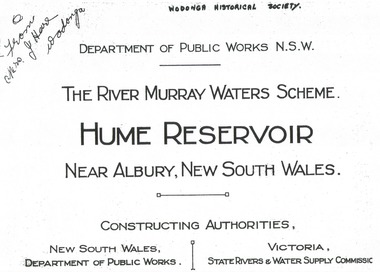
Album - Hume Reservoir Australia Album - Title Page, Department of Public Works, N.S.W, 1927
... development of the Hume Reservoir up to 1927. It was the largest water reservoir in the British Empire. The album records the pioneering engineering work that went into its construction. Hume Reservoir Australia River Murray ...This set of photos is from a leather bound album bearing the inscription "HUME RESERVOIR AUSTRALIA" plus 'The Rt. Hon. L. C. M. S. Amery, P. C., M .P.' all inscribed in gold. It was presented to The Rt. Hon. L. C. M. S. Amery, P. C., M. P, Secretary of State for Dominion Affairs on the occasion of his visit to the Hume Reservoir on 2nd November 1927. To ensure preservation of the album and its contents, the images and information pages have all been digitised. It is assumed that over the past 70 to 80 years there has been some loss of contrast due to fading, and probably detail. Thus, each photo was enhanced in several steps. Digitalisation of the album was completed by Eric Eulenstein in Wodonga in April 2002. The position of Secretary of State for Dominion Affairs was a British cabinet-level position created in 1925 and responsible for British relations with the Dominions — Canada, Australia, New Zealand, South Africa, Newfoundland, and the Irish Free State — and the self-governing Crown colony of Southern Rhodesia.This album is of local and national significance as it documents the planning and development of the Hume Reservoir up to 1927. It was the largest water reservoir in the British Empire. The album records the pioneering engineering work that went into its construction.Title page of album, including official name and construction authorities."DEPARTMENT OF PUBLIC WORKS N.S.W./ (FROM MRS J. HORE WODONGA) /THE RIVER MURRAY WATER SCHEME./ HUME RESERVOIR NEAR ALBURY, NEW SOUTH WALES/CONSSTUCTING AUTHORITIES,/ NEW SOUTH WALES/DEPARTMENT OF PUBLIC WORKS/VICTORIA/STATE RIVERS & WATER COMMISSION"hume reservoir australia, river murray waters scheme -
 Wodonga & District Historical Society Inc
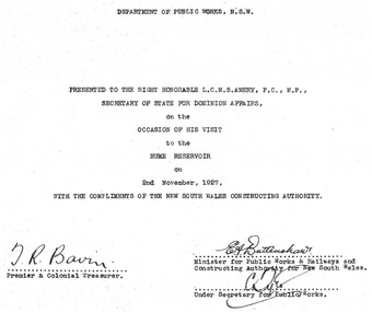
Album - Hume Reservoir Australia Album - Dedication, Department of Public Works, N.S.W, 1927
... development of the Hume Reservoir up to 1927. It was the largest water reservoir in the British Empire. The album records the pioneering engineering work that went into its construction. Hume Reservoir Australia River Murray ...This set of photos is from a leather bound album bearing the inscription "HUME RESERVOIR AUSTRALIA" plus 'The Rt. Hon. L. C. M. S. Amery, P. C., M .P.' all inscribed in gold. It was presented to The Rt. Hon. L. C. M. S. Amery, P. C., M. P, Secretary of State for Dominion Affairs on the occasion of his visit to the Hume Reservoir on 2nd November 1927. To ensure preservation of the album and its contents, the images and information pages have all been digitised. It is assumed that over the past 70 to 80 years there has been some loss of contrast due to fading, and probably detail. Thus, each photo was enhanced in several steps. Digitalisation of the album was completed by Eric Eulenstein in Wodonga in April 2002. The position of Secretary of State for Dominion Affairs was a British cabinet-level position created in 1925 and responsible for British relations with the Dominions — Canada, Australia, New Zealand, South Africa, Newfoundland, and the Irish Free State — and the self-governing Crown colony of Southern Rhodesia.This album is of local and national significance as it documents the planning and development of the Hume Reservoir up to 1927. It was the largest water reservoir in the British Empire. The album records the pioneering engineering work that went into its construction. Hume Reservoir Australia Album - Dedication page recording the presentation of the album to 'The Rt. Hon. L. C. M. S. Amery, P. C., M.P" and his visit to Albury in 1927. “DEPARTMENT OF PUBLIC WORKS, N.S.W./ PRESENTED TO THE RIGHT HONOURABLE L.C.M.S. AMERY, F.C., M.P.,/ SECRETARY OF STATE FOR DOMINION AFFAIRS/ on the/ OCCASION OF HIS VISIT/ to the /HUME RESERVOIR/ on/ 2ND NOVEMBER 1927, /WITH THE COMPLIMENTS OF THE NEW SOUTH WALES CONSTRUCTING AUTHORITY./(SIGNED) T.R. BAVIN, Premier & Colonial Treasurer./ E.A. BATTENSHAW, Minister for Public Works & Railways and Constructing Authority for New South Wales/ C. TYLE, Under Secretary for Public Works”hume reservoir australia, river murray waters scheme -
 Wodonga & District Historical Society Inc
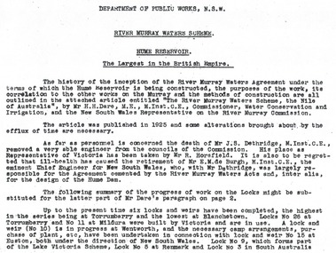
Album - Hume Reservoir Australia Album - Introduction - Part 1, Department of Public Works, N.S.W, 1927
... development of the Hume Reservoir up to 1927. It was the largest water reservoir in the British Empire. The album records the pioneering engineering work that went into its construction. Hume Reservoir Australia River Murray ...This set of photos is from a leather bound album bearing the inscription "HUME RESERVOIR AUSTRALIA" plus 'The Rt. Hon. L. C. M. S. Amery, P. C., M .P.' all inscribed in gold. It was presented to The Rt. Hon. L. C. M. S. Amery, P. C., M. P, Secretary of State for Dominion Affairs on the occasion of his visit to the Hume Reservoir on 2nd November 1927. This album is of local and national significance as it documents the planning and development of the Hume Reservoir up to 1927. It was the largest water reservoir in the British Empire. The album records the pioneering engineering work that went into its construction.RIVER MURRAY WATERS SCHEME, HUME RESERVOIR THE LARGEST IN THE BRITISH EMPIRE. ' The history of the inception of the River Murray Waters Agreement under the terms of which the Hume Reservoir is being constructed, the purposes of the work, its correlation to the other works on the Murray and the methods of construction are all outlined in the attached article entitled “The River Murray Waters Scheme, the Nile of Australia”, by Mr H.H. Dare, M.E., M.Inst.C.E., Commissioner, Water Conservation and Irrigation, and the New South Wales Representative on the River Murray Commission. The article was published in 1925 and some alterations brought about by the efflux of time are necessary. As far as personnel is concerned, the death of Mr J.S. Dethridge, M.Inst.C.E., removed a very able engineer from the councils of the Commission. His place as Representative of Victoria has been taken by Mr R. Horsfield. It is also to be regretted that ill-health has caused the retirement of Mr E.M. de Burgh, M.Inst.C.E., the eminent Chief Engineer for New South Wales, who, with Mr Dethridge, was largely responsible for the Agreement cemented by the River Murray Waters Acts and, inter alia, for the design of the Hume Dam. The following summary of the progress of work on the Locks might be substituted for the latter part of Mr Dare’s paragraph. Up to the present time six locks and weirs have been completed, the highest in the series being at Torrumberry and the lowest at Blanchetown. Locks No.26 at Torrumberry and No.11 at Mildura were built by Victoria and are in use. A lock and weir (No.10) is in progress at Wentworth, and the necessary camp arrangements, purchase of plant, etc., have been undertaken in connection with lock and weir No.15 at Euston, both under the direction of New South Wales. Lock No.9, which forms part of the Lake Victoria Scheme, Lock No.5 at Renmark and Lock No.3 in South Australia hume reservoir australia, river murray waters scheme -
 Wodonga & District Historical Society Inc
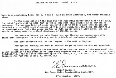
Album - Hume Reservoir Australia Album - Introduction - Part 2, Department of Public Works, N.S.W, 1927
... development of the Hume Reservoir up to 1927. It was the largest water reservoir in the British Empire. The album records the pioneering engineering work that went into its construction. Hume Reservoir Australia River Murray ...This set of photos is from a leather bound album bearing the inscription "HUME RESERVOIR AUSTRALIA" plus 'The Rt. Hon. L. C. M. S. Amery, P. C., M .P.' all inscribed in gold. It was presented to The Rt. Hon. L. C. M. S. Amery, P. C., M. P, Secretary of State for Dominion Affairs on the occasion of his visit to the Hume Reservoir on 2nd November 1927. This album is of local and national significance as it documents the planning and development of the Hume Reservoir up to 1927. It was the largest water reservoir in the British Empire. The album records the pioneering engineering work that went into its construction.DEPARTMENT OF PUBLIC WORKS, N.S.W. (continued from previous image). have been completed, Locks Nos. 2, 4 and 6, also in South Australia, are under construction. In the description of the Hume Dam the following emendations have to be made. The total length will be 5,300 feet of which 4,258 feet will consist of an earthen embankment. The maximum depth of water conserved will be 24 feet more than originally intended with an additional allowance of 9 feet for surcharge, the total capacity will be 2,000,000 acre feet, the water surface at full supply level 44,000 acres, and provision is being made for a flood discharge of 182,000 cusecs. For handy reference, the main dimensions and figures and comparisons with other dams throughout the world are given in a tabulated statement attached. The Hume Reservoir will be the largest in the British Empire. Photographs showing the work at various stages of construction are appended. The Resident Engineer for New South Wales from the start of the work until his recent promotion to the position of Inspecting Engineer was Mr J. Keith Ross, M.A., B.Sc., A.M.Inst.C.E., who has been succeeded by Mr S.W. Jones, B.E., A.M.Inst.C.E. The Resident Engineer for Victoria is Mr A.W. Johnson, B.E. (Signed) M. Inst.C.E. Chief Engineer New South Wales Constructing Authority 27th October 1927. hume reservoir australia, river murray waters scheme -
 Wodonga & District Historical Society Inc
Album - Hume Reservoir Australia Album - Dimensions of Hume Reservoir, Department of Public Works, N.S.W, 1927
... development of the Hume Reservoir up to 1927. It was the largest water reservoir in the British Empire. The album records the pioneering engineering work that went into its construction. Hume Reservoir Australia River Murray ...This set of photos is from a leather bound album bearing the inscription "HUME RESERVOIR AUSTRALIA" plus 'The Rt. Hon. L. C. M. S. Amery, P. C., M .P.' all inscribed in gold. It was presented to The Rt. Hon. L. C. M. S. Amery, P. C., M. P, Secretary of State for Dominion Affairs on the occasion of his visit to the Hume Reservoir on 2nd November 1927. This album is of local and national significance as it documents the planning and development of the Hume Reservoir up to 1927. It was the largest water reservoir in the British Empire. The album records the pioneering engineering work that went into its construction.Table outlining the Dimensions of the Hume Weir and comparisons with MAKWAR and BURRINJUCK DAMS, and some other comparisons. MAKWAR Dam is located on the Blue Nile about five miles south of Sennar and 175 miles south of Khartoum in Sudan. The construction of this dam started in 1922 and was completed in May 1925, while the British Empire colonised Sudan. It was officially opened on 21st January 1926. The BURRINJUCK DAM is situated in the upper catchment of the Murrumbidgee River, approximately 60 kms from Yass, N.S.W. It was built from 1907 to 1927 The stated purpose of the Hume Reservoir is to get storage to ensure regulated output for:- 1. Irrigation 2. Navigation 3. Hydro-electric Generation.hume reservoir australia, river murray waters scheme, hume dimensions -
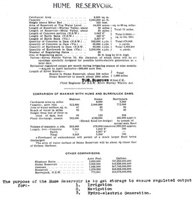
 Wodonga & District Historical Society Inc
Album - Hume Reservoir Australia Album - Plans and Progress Photos - River Murray Water Scheme, Department of Public Works, N.S.W, 1927
... development of the Hume Reservoir up to 1927. It was the largest water reservoir in the British Empire. The album records the pioneering engineering work that went into its construction. Hume Reservoir Australia River Murray ...This set of photos is from a leather bound album bearing the inscription "HUME RESERVOIR AUSTRALIA" plus 'The Rt. Hon. L. C. M. S. Amery, P. C., M .P.' all inscribed in gold. It was presented to The Rt. Hon. L. C. M. S. Amery, P. C., M. P, Secretary of State for Dominion Affairs on the occasion of his visit to the Hume Reservoir on 2nd November 1927. This album is of local and national significance as it documents the planning and development of the Hume Reservoir up to 1927. It was the largest water reservoir in the British Empire. The album records the pioneering engineering work that went into its construction.1. Locality Plan and Plan of Dam. The dam is about ten miles by road upstream from Albury and about three-quarters of a mile below the confluence of the Mitta Mitta River and the Murray River. Its main features consist of a concrete portion across the bed of the river with earth embankment at both ends. The foundations throughout are on hard granite, found at an average depth of about 40 feet below the surface, the centre line being located to take advantage of the most favourable rock levels.Heading on page "WORKS UNDER RIVER MURRAY WATERS AGREEMENT/HUME RESERVOIR" Beneath top diagram "FIG. 1. ELEVATION" Beneath second diagram "FIG. 2. PLAN" On map "LOCALITY PLAN"hume reservoir australia, river murray waters scheme, hume weir diagrams, hume weir location -
 Wodonga & District Historical Society Inc
Album - Hume Reservoir Australia Album - Detailed plan and explanation, Department of Public Works, N.S.W, 1927
... development of the Hume Reservoir up to 1927. It was the largest water reservoir in the British Empire. The album records the pioneering engineering work that went into its construction. Hume Reservoir Australia River Murray ...This set of photos is from a leather bound album bearing the inscription "HUME RESERVOIR AUSTRALIA" plus 'The Rt. Hon. L. C. M. S. Amery, P. C., M .P.' all inscribed in gold. It was presented to The Rt. Hon. L. C. M. S. Amery, P. C., M. P, Secretary of State for Dominion Affairs on the occasion of his visit to the Hume Reservoir on 2nd November 1927. This album is of local and national significance as it documents the planning and development of the Hume Reservoir up to 1927. It was the largest water reservoir in the British Empire. The album records the pioneering engineering work that went into its construction.2. Detail Plan and Section. Starting from the New South Wales and there will be an earthen embankment 430 feet 6 inches long which is retained by the North Wing Wall. Then come the sluice section 284 feet 3 inches long, the spillway 720 feet long and the South Wing Wall, making a total length of 1,042 feet 6 inches of concrete wall. Beyond the South Wing Wall is earth embankment again to a length of 3,827 feet. The Full Supply Level is R.L.626.00 and allowance has been made for a surcharge of 9 feet. A road will run along the top of the dam at R.L.642.00. The sluice section contains seven offlets, the three nearest the north wing wall being 13 feet in diameter for hydro-electric purposes and the other four 9 feet in diameter for regulation purposes only. There are to be stony sluice gates on the upstream ends of the outlets and needle valves on the downstream ends. The shock of the discharged water will be taken by a stilling pool. Trash racks will protect the intake ends of the outlets. Next comes the spillway section, which is curved on the downstream face, and carried up to within 15 feet of the full supply level. Above that will be a series of piers between which will be the flood gates and on top of which the roadway will be carried. The gates will be 20 feet wide and 15 feet high and will be 29 in number. They will slide down the face of the wall when opened for the escape of the water. The investigation of the control of this cascade of water was made by means of a model and as a result the form of “bucket” or energy dissipater shown on the section of the spillway was decided upon. The earth embankment in Victoria is being constructed by the State Rivers and Water Supply Commission of Victoria who are the Constructing Authority for that State under the River Murray Waters Agreement. The core of the embankment is of concrete 6 feet wide at the base tapering to 2 feet at the top end and is reinforced with steel rods from the level of the decomposed rock upwards. On the downstream side, at about natural surface level, is a tunnel for drainage and inspection purposes. Above the tunnel is a vertical layer of large stones to drain any seepage to the tunnel. Against the core wall is packed selected material of as impervious a character as can be got locally and beyond that the bank is carefully built up in horizontal layers by means of horses and wheel scoops. The upstream slope is 3-to-1 hardening to 2½-to-1 at the top and the downstream slope is 2½-to-1 hardening to 2.07-to-1 at the top. The thrust of the upstream toe is taken by a mass of granite blocks, and this face is protected by concrete laid in situ. The width of the bank at base is 650 feet and at top 32 feet.hume reservoir australia, river murray waters scheme, hume weir diagrams, hume plan details -
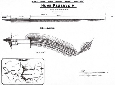
 Wodonga & District Historical Society Inc
Album - Hume Reservoir Australia Album - Hume Reservoir Detailed diagrams, Department of Public Works, N.S.W, 1927
... development of the Hume Reservoir up to 1927. It was the largest water reservoir in the British Empire. The album records the pioneering engineering work that went into its construction. Hume Reservoir Australia River Murray ...This set of photos is from a leather bound album bearing the inscription "HUME RESERVOIR AUSTRALIA" plus 'The Rt. Hon. L. C. M. S. Amery, P. C., M .P.' all inscribed in gold. It was presented to The Rt. Hon. L. C. M. S. Amery, P. C., M. P, Secretary of State for Dominion Affairs on the occasion of his visit to the Hume Reservoir on 2nd November 1927. This album is of local and national significance as it documents the planning and development of the Hume Reservoir up to 1927. It was the largest water reservoir in the British Empire. The album records the pioneering engineering work that went into its construction.6 Diagrams showing the details of the Hume Reservoir structure. On the left from the top of the page to bottom are:- ELEVATION LOOKING UPSTREAM, PLAN aTYPICAL SECTION OF EARTHEN EMBANKMENT. ' On the right from top to bottom are:- SECTIONAL - ELEVATION OF SPILLWAY & TAIL WATER ENERGY DISSIPATOR, SECTION THROUGH REGULATING OUTLETS and SECTION THROUGH TURBINE OUTLETS.hume reservoir australia, river murray waters scheme, hume weir diagrams, hume plan details -
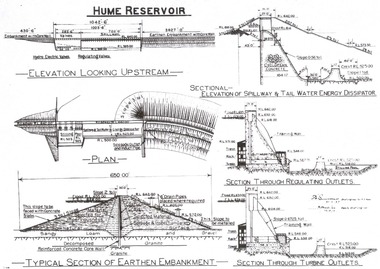
 Wodonga & District Historical Society Inc
Album - Hume Reservoir Australia Album - View of site on 28th November 1919
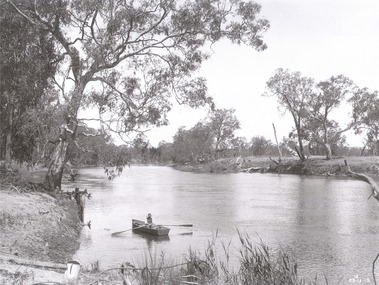
... development of the Hume Reservoir up to 1927. It was the largest water reservoir in the British Empire. The album records the pioneering engineering work that went into its construction. Hume Reservoir Australia River Murray ...This set of photos is from a leather bound album bearing the inscription "HUME RESERVOIR AUSTRALIA" plus 'The Rt. Hon. L. C. M. S. Amery, P. C., M .P.' all inscribed in gold. It was presented to The Rt. Hon. L. C. M. S. Amery, P. C., M. P, Secretary of State for Dominion Affairs on the occasion of his visit to the Hume Reservoir on 2nd November 1927. This album is of local and national significance as it documents the planning and development of the Hume Reservoir up to 1927. It was the largest water reservoir in the British Empire. The album records the pioneering engineering work that went into its construction.DEPARTMENT OF PUBLIC WORKS, N.S.W. RIVER MURRAY WATERS SCHEME. HUME RESERVOIR. 3. View of site on 28th November 1919 when the first sod was turned by the Governor General Sir Ronald Munro Ferguson, now Lord Hovar. The view is taken from the New South Wales end of the dam looking across the Murray to Victoria. The Murray flows from left to right.hume reservoir australia, river murray waters scheme, hume weir diagrams, hume plan details -
 Wodonga & District Historical Society Inc
Album - Hume Reservoir Australia Album - The River Murray at the site of the dam 28th November, 1919
... development of the Hume Reservoir up to 1927. It was the largest water reservoir in the British Empire. The album records the pioneering engineering work that went into its construction. Hume Reservoir Australia River Murray ...This set of photos is from a leather bound album bearing the inscription "HUME RESERVOIR AUSTRALIA" plus 'The Rt. Hon. L. C. M. S. Amery, P. C., M .P.' all inscribed in gold. It was presented to The Rt. Hon. L. C. M. S. Amery, P. C., M. P, Secretary of State for Dominion Affairs on the occasion of his visit to the Hume Reservoir on 2nd November 1927. This album is of local and national significance as it documents the planning and development of the Hume Reservoir up to 1927. It was the largest water reservoir in the British Empire. The album records the pioneering engineering work that went into its construction.DEPARTMENT OF PUBLIC WORKS, N.S.W. RIVER MURRAY WATERS SCHEME. HUME RESERVOIR. The River Murray at the site of the dam on 28th November 1919 looking upstream. hume reservoir australia, river murray waters scheme, hume weir diagrams, hume plan details -
 Wodonga & District Historical Society Inc
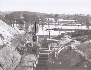
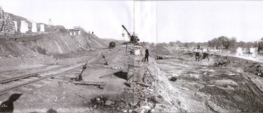
Album - Hume Reservoir Australia Album - Foundations for core wall of earth embankment, September 1921
... development of the Hume Reservoir up to 1927. It was the largest water reservoir in the British Empire. The album records the pioneering engineering work that went into its construction. Hume Reservoir Australia River Murray ...This set of photos is from a leather bound album bearing the inscription "HUME RESERVOIR AUSTRALIA" plus 'The Rt. Hon. L. C. M. S. Amery, P. C., M .P.' all inscribed in gold. It was presented to The Rt. Hon. L. C. M. S. Amery, P. C., M. P, Secretary of State for Dominion Affairs on the occasion of his visit to the Hume Reservoir on 2nd November 1927. This album is of local and national significance as it documents the planning and development of the Hume Reservoir up to 1927. It was the largest water reservoir in the British Empire. The album records the pioneering engineering work that went into its construction.DEPARTMENT OF PUBLIC WORKS, N.S.W. RIVER MURRAY WATERS SCHEME. HUME RESERVOIR. 5. Foundations for core wall of earth embankment in New South Wales in September 1921. The River Murray in flood.hume reservoir australia, river murray waters scheme, hume weir diagrams, hume plan details -
 Wodonga & District Historical Society Inc
Album - Hume Reservoir Australia Album - Excavations for foundations of spillway, September 1921
... development of the Hume Reservoir up to 1927. It was the largest water reservoir in the British Empire. The album records the pioneering engineering work that went into its construction. Hume Reservoir Australia River Murray ...This set of photos is from a leather bound album bearing the inscription "HUME RESERVOIR AUSTRALIA" plus 'The Rt. Hon. L. C. M. S. Amery, P. C., M .P.' all inscribed in gold. It was presented to The Rt. Hon. L. C. M. S. Amery, P. C., M. P, Secretary of State for Dominion Affairs on the occasion of his visit to the Hume Reservoir on 2nd November 1927. This album is of local and national significance as it documents the planning and development of the Hume Reservoir up to 1927. It was the largest water reservoir in the British Empire. The album records the pioneering engineering work that went into its construction.DEPARTMENT OF PUBLIC WORKS, N.S.W. RIVER MURRAY WATERS SCHEME. HUME RESERVOIR. 6. Excavation in progress for foundations of outlet and spillway sections of dam. September 1921.hume reservoir australia, river murray waters scheme, hume weir diagrams, hume plan details