Showing 65 items matching "navigator street"
-
 Sunshine and District Historical Society Incorporated
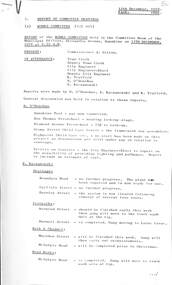
Administrative record - City of Sunshine - Commissioner Mr Alexander Alex George Gillon Collection 1976 - 1982 - Report of committee meetings 12th December 1978, City of Sunshine, 12th December 1978
... ...Navigator Street...Lease 2 - 4 Burton Crescent Subdivision of Land Fairbairn Road Proposed Rezoning of Land Laurel Street Planning Permit Bank extension Hampshire Road Planning Permit hairdressing Salon Hampshire Road Planning Permit factory Cromer Avenue Planning Permit Community Health Centre Andrea Street Planning Permit Educational Establishment Navigator Street Planning Permit Additions to existing church Ballarat Road Deer Park Planning Permit Entertainment Complex (Malibu grand Prix) Ballarat Road and Geelong Road Planning Permit Place of Assembly Hutchinson Street Construction of Justin Road Construction of laneway rear of Sydney Street between King Edward Avenue and Ridley street Planning Permit Flats Warrs Road and Fabian Court...Albans Hampshire Road Sunshine Cromer Avenue Sunshine North Andrea Street Navigator Street Ballarat Road Deer Park Geelong Road Braybrook Brooklyn Hutchinson Street Albion Justin Road Sydney Street King Edward Avenue Warrs Road Fabian Court Lease 2 - 4 Burton Crescent Subdivision of Land Fairbairn Road Proposed Rezoning of Land Laurel Street Planning Permit Bank extension Hampshire Road Planning Permit hairdressing Salon Hampshire Road Planning Permit factory Cromer Avenue Planning Permit Community Health Centre Andrea Street Planning Permit Educational Establishment Navigator Street Planning Permit Additions to existing church Ballarat Road Deer Park Planning Permit Entertainment Complex (Malibu grand Prix) Ballarat Road and Geelong Road Planning Permit Place of Assembly Hutchinson Street Construction of Justin Road Construction of laneway rear of Sydney Street between King Edward Avenue and Ridley street Planning Permit Flats Warrs Road and Fabian Court Foolscap sized document. ...Lease 2 - 4 Burton Crescent Subdivision of Land Fairbairn Road Proposed Rezoning of Land Laurel Street Planning Permit Bank extension Hampshire Road Planning Permit hairdressing Salon Hampshire Road Planning Permit factory Cromer Avenue Planning Permit Community Health Centre Andrea Street Planning Permit Educational Establishment Navigator Street Planning Permit Additions to existing church Ballarat Road Deer Park Planning Permit Entertainment Complex (Malibu grand Prix) Ballarat Road and Geelong Road Planning Permit Place of Assembly Hutchinson Street Construction of Justin Road Construction of laneway rear of Sydney Street between King Edward Avenue and Ridley street Planning Permit Flats Warrs Road and Fabian Court city of sunshine, alexander "alex" george gillon, burton crescent, maribyrnong, fairbairn road, sunshine west, laurel street, st. albans, hampshire road, sunshine, cromer avenue, sunshine north, andrea street, navigator street, ballarat road, deer park, geelong road, braybrook, brooklyn, hutchinson street, albion, justin road, sydney street, king edward avenue, warrs road, fabian court -
 Warrnambool and District Historical Society Inc.
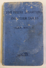
Book, Five figure logarithmic and other tables, 1909
... Street (south of Merri St) Warrnambool great-ocean-road Logarithm tables have been used for centuries to calculate complex mathematics. Tables were recorded and looked up instead of completing these calculations. This book is an example of these calculations. They were commonly used in many fields including engineers, navigators ...Logarithm tables have been used for centuries to calculate complex mathematics. Tables were recorded and looked up instead of completing these calculations. This book is an example of these calculations. They were commonly used in many fields including engineers, navigators and scientists. An item commonly used by people in the mathematical field. Owned by a local person and sold by a local business in Warrnambool.Small blue hard- covered book with cloth finish. Title in black text. Edge of pages is coloured red. 161 pages. G Phillpot VX121575 inside front cover. Walter Davies Bookseller Warrnambool stamp on title page. Author and preface by Alex McAulay.logarithm tables, warrnambool, walter davies bookseller warrnambool, alex mcaulay. -
 Flagstaff Hill Maritime Museum and Village
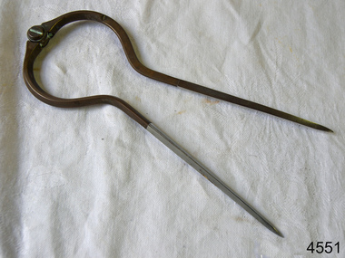
Dividers, Early 20th Century
... Flagstaff Hill Maritime Museum and Village 89 Merri Street Warrnambool great-ocean-road Dividers are used by navigators to measure the distance between two points on a map or chart. ...Dividers are used by navigators to measure the distance between two points on a map or chart. Each point of the divider is places on a map point, then the distance between the points of the divider is measured against the scale of the chart or map. This helps determine the ship's path of travel, the distance travelled and the current location.Not very significant as not associated with any historical event or person, same pattern of dividers is available today from many retail outlets. Also item was probably made around 1940s to 1950sDividers; brass navigator's dividers with fine, stainless steel points. Made in Britain by W & H C (inscription). This navigational tool is used by a ship's navigator to mark the ship's position. Each end point of the divider is placed on a position on a chart or map, then the length between the points of the divider is measured on the chart's scale.Inscribed "British Made" and "W & H C". flagstaff hill, warrnambool, shipwrecked-coast, flagstaff-hill, flagstaff-hill-maritime-museum, maritime-museum, shipwreck-coast, flagstaff-hill-maritime-village, navigational dividers, navigational tool, dividers made by w & hc, w & hc britain -
 Mission to Seafarers Victoria
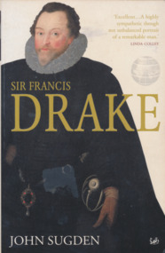
Book, John Sugden, Sir Francis Drake, 2006
... Mission to Seafarers Victoria 717 Flinders Street Docklands melbourne sea exploration navigators francis drake explorators More than four hundred years after his death, Sir Francis Drake remains one of the legendary figures of history. ...More than four hundred years after his death, Sir Francis Drake remains one of the legendary figures of history. His career is one of the most colourful on record. The most daring of the corsairs who raided the West Indies and Spanish Main, he led the English into the Pacific, and circumnavigated the world to bring home the Golden Hind laden with Spanish treasure. His attacks on Spanish cities and ships transformed his private war into a struggle for survival between Protestant England and Catholic Spain, in which he became Elizabeth I's most prominent admiral. His exploits marked the emergence of England as a major maritime nation.Pocket booknon-fictionMore than four hundred years after his death, Sir Francis Drake remains one of the legendary figures of history. His career is one of the most colourful on record. The most daring of the corsairs who raided the West Indies and Spanish Main, he led the English into the Pacific, and circumnavigated the world to bring home the Golden Hind laden with Spanish treasure. His attacks on Spanish cities and ships transformed his private war into a struggle for survival between Protestant England and Catholic Spain, in which he became Elizabeth I's most prominent admiral. His exploits marked the emergence of England as a major maritime nation.sea exploration, navigators, francis drake, explorators -
 Mission to Seafarers Victoria
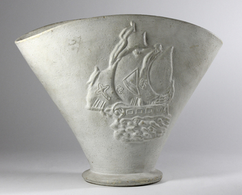
Decorative object - Vase, mid 20th Century
... Street Docklands melbourne The caravel type ship with the cross represents the Santa Maria of Christopher Columbus. It is one of the symbols of the great sea explorers. A similar vase on sale on Ebay (April 2023) suggesting it was mass produced. One of the many decorative furnishings which date from the intense service periods of the Mission from the 1930s through to the 1960s. vase ship caravel santa maria sea exploration great navigators White painted ceramic vase on shallow circular foot with relief design of a stylised sailing ship (caravel) on one side. ...The caravel type ship with the cross represents the Santa Maria of Christopher Columbus. It is one of the symbols of the great sea explorers. A similar vase on sale on Ebay (April 2023) suggesting it was mass produced.One of the many decorative furnishings which date from the intense service periods of the Mission from the 1930s through to the 1960s. White painted ceramic vase on shallow circular foot with relief design of a stylised sailing ship (caravel) on one side. Original colour appears to have been green.The foremost sail of the ship bears a cross; small chip on rim.vase, ship, caravel, santa maria, sea exploration, great navigators -
 Mission to Seafarers Victoria
Book, A. E. M. Bayliss, Dampier's Voyages, 1945
... Mission to Seafarers Victoria 717 Flinders Street Docklands melbourne keith oliver donation navigators dampier Dampier's Voyages Book A. ...non-fictionkeith oliver, donation, navigators, dampier -
 Port Melbourne Historical & Preservation Society
Photograph - Shipping at Station Pier and Webb Dock, Port Melbourne, 2001
... Port Melbourne Historical & Preservation Society Port Melbourne Town Hall 333 Bay Street Port Melbourne melbourne further updates from the collection of Ron Laing great coverage of Port Melbourne photographs donated to the Society transport - shipping piers and wharves - station pier pacific sky regal princess seven seas navigator tasmanian achiever - brambles ro ro hmas darwin hmas adelaide hmas anzac hmas warramunga n z tekaha hmas wallaroo 11 colour photographs of shipping at Station Pier and nearby Webb Dock, cruise and naval vessels (.11 currently absent March 2014) Photograph Shipping at Station Pier and Webb Dock, Port Melbourne ...further updates from the collection of Ron Laing great coverage of Port Melbourne photographs donated to the Society11 colour photographs of shipping at Station Pier and nearby Webb Dock, cruise and naval vessels (.11 currently absent March 2014)transport - shipping, piers and wharves - station pier, pacific sky, regal princess, seven seas navigator, tasmanian achiever - brambles ro ro, hmas darwin, hmas adelaide, hmas anzac, hmas warramunga, n z tekaha, hmas wallaroo -
 Flagstaff Hill Maritime Museum and Village
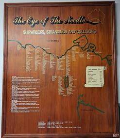
Artwork, other - Shipwreck Board, The Eye of the Needle: Shipwrecks, Stranding's and Collisions, ca 2002
... Flagstaff Hill Maritime Museum and Village 89 Merri Street Warrnambool great-ocean-road The Shipwreck Board is a feature of Flagstaff Hill Maritime Museum and Village/ its subject is explained briefly in the Museum's handbook, The Flagstaff Hill Navigator, published in 2008: - "Known as the ‘Eye of the Needle’ the treacherous entrance to Bass Strait is littered with the wreckage of large international vessels and smaller sail and steam craft used in coastal trade. ...The Shipwreck Board is a feature of Flagstaff Hill Maritime Museum and Village/ its subject is explained briefly in the Museum's handbook, The Flagstaff Hill Navigator, published in 2008: - "Known as the ‘Eye of the Needle’ the treacherous entrance to Bass Strait is littered with the wreckage of large international vessels and smaller sail and steam craft used in coastal trade. The vessels bringing emigrants and cargo to Australia found the western entrance to Bass Strait the most dangerous part of their voyage. They had to thread their way between the southern point of Victoria (Cape Otway) and the northern point of King Island, a stretch of water less than 90 km wide. Many smaller coastal vessels were lost at Portland, Port Fairy, Warrnambool and Apollo Bay which are not safe harbours in certain weather conditions. "The Shipwreck Board shows shipwrecks, strandings and collisions which occurred in this area up to the year 1940. Wrecks are identified by a yellow light and collisions/strandings by a green light. These lights also identify the decade the wreck occurred by lighting up when the relevant decade button is pushed. Interesting happenings of the decades are listed next to the buttons." The Shipwreck Board's demonstration of The Eye of the Needle is an interactive visual display that helps teach the perils and dangers faced by early settlers in Victoria. It tells of the vast number of lives lost. It lists the names of many infamous shipwrecks and significant events.The large stained and lacquered timber board is mounted in a timber, frame. It is painted with a small sketch of Australia, and an enlarged outline of the southern coast of Victoria, King Island and the North West coast of Tasmania. The interactive display highlights the shipwrecks, standings and collisions suffered by many vessels as they navigated the 'Eye of the Needle', a narrow stretch of Bass Strait. The locations of the Lighthouses are pinpointed. Lists of groups of ships are below the coastlines. A painted scroll shows eight major shipwrecks with the number of lives lost for each one. A table shows historical facts associated with the decades from pre-1830 to 1940. A system of coloured lights compares the decades with the vessels that suffered damage. The board was created by artist and signwriter, Alex O'Flynn Computer Signs.flagstaff hill, maritime museum, maritime village, shipwreck coast, eye of the needle, shipwreck locations, bass strait, basses strait, king island, north west tasmania, south coast of victoria, cape otway, victorian lighthouse, king island lighthouse, strandings, coastal tracers, emigrant ships, sea trade, 1930s-1940s, shipwreck board, the eye of the needle, collosions, alex o'flynn, alex o’flynn computer signs, shipwrecks of western victoria -
 Flagstaff Hill Maritime Museum and Village
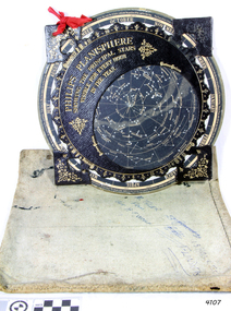
Planisphere, Early 20th Century
... A significant item of celestial mapping used by marine navigators This particular item was made and used in the first quarter to half of the 20th century flagstaff hill warrnambool shipwrecked-coast flagstaff-hill flagstaff-hill-maritime-museum maritime-museum shipwreck-coast flagstaff-hill-maritime-village planisphere star map marine navigation maps george philip & sons "Made in Germany for GEORGE PHILIP & SONS Ltd. Geographical and Educational Depot, 32 Fleet Street ...The word Planisphere (Latin planisphaerium) was originally used in the second century by Claudius Ptolemy to describe the representation of a spherical Earth by a map drawn in the plane. This usage continued into the Renaissance: for example Gerardus Mercator described his 1569 world map as a Planisphere. The word describes the representation of the star-filled celestial sphere on the plane. The first star chart to have the name "Planisphere" was made in 1624 by Jacob Bartsch. Bartsch was the son-in-law of Johannes Kepler, discoverer of Kepler's laws of planetary motion. A significant item of celestial mapping used by marine navigators This particular item was made and used in the first quarter to half of the 20th centuryPlanisphere of northern hemisphere, with canvas bag. Planisphere consists of a circular star chart attached at its centre to an opaque circular overlay that has a clear elliptical window or hole so that only a portion of the sky map will be visible in the window or hole area at any given time. The chart and overlay are mounted so that they are free to rotate about a common pivot point at their centres. The star chart contains the brightest stars, constellations and (possibly) deep-sky objects visible from a particular latitude on Earth. The night sky that one sees from the Earth depends on whether the observer is in the northern or southern hemispheres and the latitude. A Planisphere window is designed for a particular latitude and will be accurate enough for a certain band either side of that. Planisphere makers will usually offer them in a number of versions for different latitudes. Planispheres only show the stars visible from the observer's latitude; stars below the horizon are not included. A complete twenty-four-hour time cycle is marked on the rim of the overlay. A full twelve months of calendar dates are marked on the rim of the starchart. The window is marked to show the direction of the eastern and western horizons. The disc and overlay are adjusted so that the observer's local time of day on the overlay corresponds to that day's date on the star chart disc. The portion of the star chart visible in the window then represents (with a distortion because it is a flat surface representing a spherical volume) the distribution of stars in the sky at that moment for the Planispheres designed location. Users hold the Planisphere above their head with the eastern and western horizons correctly aligned to match the chart to actual star positions. "Made in Germany for GEORGE PHILIP & SONS Ltd. Geographical and Educational Depot, 32 Fleet Street, London" Canvas bag has "Capt. H (Howard) Tyler from Captain H. F. Woolf" "Tyler 22 ? St East Brighton" also "13 Halls St Flinders"flagstaff hill, warrnambool, shipwrecked-coast, flagstaff-hill, flagstaff-hill-maritime-museum, maritime-museum, shipwreck-coast, flagstaff-hill-maritime-village, planisphere, star map, marine navigation, maps, george philip & sons -
 Flagstaff Hill Maritime Museum and Village
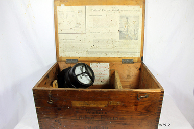
Instrument - Ship Log, Early 20th Century
... navigators. Thomas Walker & Son were internationally renowned in the manufacturing of ship logs the founding father, Thomas Walker (1805–1871), an engineer in Birmingham, patented his mechanical log in 1878 which was a recording instrument that attached to a rail at the stern of a vessel connected by a long cord with a rotor which was towed behind the ship. The instrument dial then recorded the distance travelled. Thomas Walker first went into business to manufacture stoves at 58 Oxford Street...navigators. Thomas Walker & Son were internationally renowned in the manufacturing of ship logs the founding father, Thomas Walker (1805–1871), an engineer in Birmingham, patented his mechanical log in 1878 which was a recording instrument that attached to a rail at the stern of a vessel connected by a long cord with a rotor which was towed behind the ship. The instrument dial then recorded the distance travelled. Thomas Walker first went into business to manufacture stoves at 58 Oxford Street ...In times past the only way to measure a ship’s speed was to throw a wood log into the water and observe how fast it moved away from the ship. In the 16th century, the log was fastened to a rope knotted at set intervals. The log was thrown over the stern (back) of the vessel and a crew member counted the number of knots that were paid out in a set time. From this, they could estimate the vessel's speed through the water. This was known as streaming the log and is also the derivation of the knot as a measurement of nautical speed. Various manufacturers of nautical equipment had sought over the years to perfect the operation of determining a ship's speed and it wasn't until Thomas Walker and his son Ferdinand developed a mechanical system that eventually made this task became easy for marine navigators. Thomas Walker & Son were internationally renowned in the manufacturing of ship logs the founding father, Thomas Walker (1805–1871), an engineer in Birmingham, patented his mechanical log in 1878 which was a recording instrument that attached to a rail at the stern of a vessel connected by a long cord with a rotor which was towed behind the ship. The instrument dial then recorded the distance travelled. Thomas Walker first went into business to manufacture stoves at 58 Oxford Street Birmingham. Walker’s self-feeding stove was widely lauded at the Paris Exhibition of 1855, winning a prize medal and kickstarting the first of many notable innovations for the Walker family's manufacturing business. However, it wasn’t until working on an earlier ship’s log model invented by his Uncle that Thomas Walker became interested in the further development of this device, used to ascertain a ship’s speed. Walker continued to improve on the common log for the company of Massey & Sons and these improvements were deemed revolutionary. This log became a firm favourite of the West India Association (a British-based organisation promoting ties and trade with the British Caribbean), being the most common log in use for two generations. It took until 1861 for Thomas Walker and his son, Thomas Ferdinand Walker (1831-1921) to patent the first Walker log of many. Together, with the introduction of the A1 Harpoon Log two years later, they established the Walker Log Business as a force to be reckoned with. By his passing in 1871, Thomas Walker Snr had not only founded a family business with considerable staying power but also instilled a tradition of public service. Having sat as a representative on the Birmingham Town Council for 15 years and played an active role in public works, he was soon given the nickname of ‘Blue Brick Walker’. Much like his father, Thomas Ferdinand Walker changed the face of the maritime industry. His patent of 1897, the ‘Cherub’ log, was a notable departure from the past providing a far more accurate reading and replacing the majority of logs of the age. They were the first to produce an electric log (Trident) and the Walker factory was one of the first to introduce the 48-hour work week for employees.The ship log was invented and made by a significant marine instrument maker and innovator of machinery. It demonstrates the huge leap taken to improve navigational accuracy at sea with an instrument that was in use for decades.Ships Log, Walker Trident electric motor, in wooden box with instructions inside box. The motor dial with electric cord is still inside box.Inscription "Admiralty patent number 3332" and "Walker Trident Electric Ship Log (Mark III), 15-25 volt". On top of lid, hand written, is "G TAYLOR"flagstaff hill, warrnambool, shipwrecked-coast, flagstaff-hill, flagstaff-hill-maritime-museum, maritime-museum, shipwreck-coast, flagstaff-hill-maritime-village, ships log, thomas walker & son, electric ships log, marine navigation, thomas ferdinand walker, ship log -
 Flagstaff Hill Maritime Museum and Village
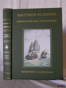
Book, Matthew Flinders Navigator and Chartmaker
... Flagstaff Hill Maritime Museum and Village 89 Merri Street Warrnambool great-ocean-road flagstaff hill warrnambool shipwrecked-coast flagstaff-hill flagstaff-hill-maritime-museum maritime-museum shipwreck-coast flagstaff-hill-maritime-village book matthew flinders navigator and chartmaker matthew flinders navigator chartmaker Matthew Flinders Navigator and Chartmaker Publisher Genesis Publications Ltd Date 1986 Matthew Flinders Navigator and Chartmaker Book ...Matthew Flinders Navigator and Chartmaker Publisher Genesis Publications Ltd Date 1986flagstaff hill, warrnambool, shipwrecked-coast, flagstaff-hill, flagstaff-hill-maritime-museum, maritime-museum, shipwreck-coast, flagstaff-hill-maritime-village, book, matthew flinders navigator and chartmaker, matthew flinders, navigator, chartmaker -
 Flagstaff Hill Maritime Museum and Village
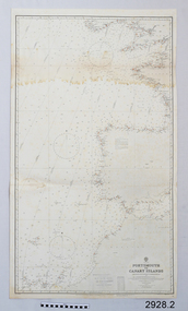
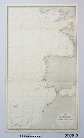
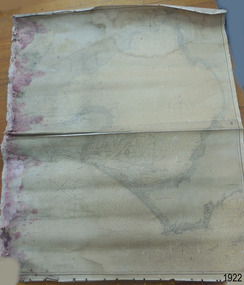
Document - Navigation Chart, Portsmouth to Canary Islands, CA. 1928
... Flagstaff Hill Maritime Museum and Village 89 Merri Street Warrnambool great-ocean-road Navigation charts are drawn by professional hydrographers and describe the geography of land and water, enabling a water based navigator on board vessels such as ships to safely negotiate between ports locally and around the world. ...Navigation charts are drawn by professional hydrographers and describe the geography of land and water, enabling a water based navigator on board vessels such as ships to safely negotiate between ports locally and around the world. They are drawn to a particular standard with common symbols noting landmarks. The charts are used in conjunction with other navigational instruments and tools to calculate the vessel’s exact location and a safe route to its destination.The set of charts and their chart are of significance as examples of equipment and documents used to navigate the oceans of the world, particularly to Australia. Migration to Australia is an important part of this country's history.British Admiralty Navigation Chart - Portsmouth to Canary Islands - printed on rectangular white paper. Published in London by the British Admiralty in 1928.warrnambool, shipwreck coast, flagstaff hill, flagstaff hill maritime museum, flagstaff hill maritime village, chart, map, navigate, navigation, location, vessel, 1928, british admiralty, hydrographer, geography, admiralty chart, portsmouth, canary islands -
 Flagstaff Hill Maritime Museum and Village
Document - Navigation Chart, Portsmouth to Canary Islands, Ca. 1928
... Street Warrnambool great-ocean-road This is an Official British Admiralty Navigation Chart, one of a set of 65 charts donated together with a wooden chart case. It was published and printed in London in 1928 by the British Admiralty. Navigation charts are drawn by professional hydrographers and describe the geography of land and water, enabling a water based navigator ...This is an Official British Admiralty Navigation Chart, one of a set of 65 charts donated together with a wooden chart case. It was published and printed in London in 1928 by the British Admiralty. Navigation charts are drawn by professional hydrographers and describe the geography of land and water, enabling a water based navigator on board vessels such as ships to safely negotiate between ports locally and around the world. They are drawn to a particular standard with common symbols noting landmarks. The charts are used in conjunction with other navigational instruments and tools to calculate the vessel’s exact location and a safe route to its destination.The set of charts and their chart are of significance as examples of equipment and documents used to navigate the oceans of the world, particularly to Australia. Migration to Australia is an important part of this country's history.British Admiralty Navigation Chart - Portsmouth to Canary Islands - printed on rectangular white paper. Published in London by the British Admiralty in 1928.warrnambool, shipwreck coast, flagstaff hill, flagstaff hill maritime museum, flagstaff hill maritime village, chart, map, navigate, navigation, location, vessel, 1928, british admiralty, hydrographer, geography, admiralty chart, portsmouth, canary islands -
 Flagstaff Hill Maritime Museum and Village
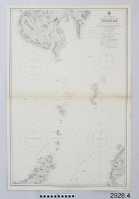
Document - Navigation Chart, Eastern Part of the Celebes Sea, Ca. 1928
... Street Warrnambool great-ocean-road This is an Official British Admiralty Navigation Chart, one of a set of 65 charts donated together with a wooden chart case. It was published and printed in London in 1928 by the British Admiralty. Navigation charts are drawn by professional hydrographers and describe the geography of land and water, enabling a water based navigator ...This is an Official British Admiralty Navigation Chart, one of a set of 65 charts donated together with a wooden chart case. It was published and printed in London in 1928 by the British Admiralty. Navigation charts are drawn by professional hydrographers and describe the geography of land and water, enabling a water based navigator on board vessels such as ships to safely negotiate between ports locally and around the world. They are drawn to a particular standard with common symbols noting landmarks. The charts are used in conjunction with other navigational instruments and tools to calculate the vessel’s exact location and a safe route to its destination.The set of charts and their chart are of significance as examples of equipment and documents used to navigate the oceans of the world, particularly to Australia. Migration to Australia is an important part of this country's history.British Admiralty Navigation Chart - Eastern Part of the Celebes Sea - printed on rectangular white paper. Published in London by the British Admiralty in 1928.warrnambool, shipwreck coast, flagstaff hill, flagstaff hill maritime museum, flagstaff hill maritime village, chart, map, navigate, navigation, location, vessel, 1928, british admiralty, hydrographer, geography, admiralty chart, celebes sea -
 Flagstaff Hill Maritime Museum and Village
Book - Reference guide, William Marshall Smart (W M Smart), Professor of Astronomy, A Handbook of Sea Navigation, 1943
... Navigator...Professor of Astronomy...1943...G.F. Byrne...Collins Book Depot...Technical Book Department...361 Swanston St....Melbourne...Frederick Henry (Harry) Slamen...361 Swanston Street...Navigator Professor of Astronomy 1943 G.F. Byrne Collins Book Depot Technical Book Department 361 Swanston St. Melbourne Frederick Henry (Harry) Slamen 361 Swanston Street Melbourne A Handbook of Sea Navigation Maritime handbook navigation instructiono sea navigation Pencil: "12/6" [12 shillings 6 pence] Sticker: "G.F. ...Author W M Smart, M.A., D.SC., F.R.A.S. (William Marshall Smart), (1889-1975) Regius Professor of Astronomy in the University of Glasgow, Instructor-Lieut. in the Royal Navy during World War I. and John Couch Adams Astronomer in the University of Cambridge. In 1943 he was elected as a fellow of the Royal Society of Edinburg. From 1949-1951 he was President of the Royal Astronomical Society and a member of the Royal Institute of Navigation. In 1958 he was awarded the Lorimer Medal of the Astronomical Society of Edinburgh. The publisher firm, Longmans, Green & Co, was originally founded in 1724 in London by Thomas Longman under the name Longman. In August of that year, he bought the two shops and goods of William Taylor and set up his publishing house there at 39 Paternoster Row. The shops were called Black Swan and Ship, and it is said that the 'ship' sign was the inspiration for Longman's Logo. After many changes of name and management, the firm was incorporated in 1926 as Longmans, Green & Co. Pty Ltd. The firm was acquired by Pearson in 1968 and was known as Pearson Longman or Pearson PLC. The book was sold by Collins Book Depot which was founded by Frederick Henry (Harry) Slamen in 1922. In 1929 the form became a Proprietary Limited Company with an additional two stores, at 95 Elizabeth and 361 Swanston Streets, Melbourne. Collins Booksellers is still owned by the Stamen family. It is the largest Australian-owned bookselling chain.The book is significant due to its connection with navigation at sea. Its author W M Smart was a learned astronomer and an Instructor-Lieutenant for the Royal Navy during World War I. His achievements were recognised in 1958 when he was awarded the Lorimer Medal of the Astronomical Society of Edinburgh.A Handbook of Sea Navigation: The Theory & Practice of Astronomical Navigation at Sea, with diagrams and charts Author: W M Smart, M.A., D.SC., F.R.A.S. (William Marshall Smart) Publisher: Longmans, Green and Co Printer: Collins Book Depot Date: 1943 Textured green hardcover book. Inscriptions on the Fly page.Pencil: "12/6" [12 shillings 6 pence] Sticker: "G.F. Byrne / Faunce Crescent / O'Connor, A.C.T. / Australia 2001" Stamp: "COLLINS BOOK DEPOT PTY. LTD. / Technical Book Department / 361 Swanston St., Melb. G - - -"flagstaff hill, flagstaff hill maritime museum and village, warrnambool, maritime museum, maritime village, great ocean road, shipwreck coast, longmans green and co., thomas longman, paternoster row london, w m smart, william marshall smart, astronomer, navigator, professor of astronomy, 1943, g.f. byrne, collins book depot, technical book department, 361 swanston st., melbourne, frederick henry (harry) slamen, 361 swanston street melbourne, a handbook of sea navigation, maritime handbook, navigation instructiono, sea navigation -
 Orbost & District Historical Society
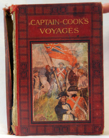
book, Cassell and Company Limited, Captain Cook's Voyages, 1908
... Orbost & District Historical Society Ruskin Street Orbost gippsland James Cook was a British explorer, navigator, cartographer, and captain in the Royal Navy. ...James Cook was a British explorer, navigator, cartographer, and captain in the Royal Navy. Cook made detailed maps of Newfoundland prior to making three voyages to the Pacific Ocean, during which he achieved the first recorded European contact with the eastern coastline of Australia and the Hawaiian Islands, and the first recorded circumnavigation of New Zealand.Cook's 12 years sailing around the Pacific Ocean contributed much to European knowledge of the area. This is a useful reference book.A 446pp hard back book titled, "Captain Cook's Voyages" in gold print. It has a black and red cover with a coloured illustration of the landing of James Cook, his crew and the planting of the British red ensign. It has coloured illustrations. Includes Aboriginal encounters with explorers. inside cover - :To Fred from his mother, mas 1910" -
 Flagstaff Hill Maritime Museum and Village
Document
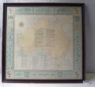
... Flagstaff Hill Maritime Museum and Village 89 Merri Street Warrnambool great-ocean-road flagstaff hill warrnambool shipwrecked-coast flagstaff-hill flagstaff-hill-maritime-museum maritime-museum shipwreck-coast flagstaff-hill-maritime-village 1) Large map of Australia with information on explorers, navigators etc involved in its discovery. ...1) Large map of Australia with information on explorers, navigators etc involved in its discovery. Title "The Discovery of Australia by Western Man" 2) Poster which explains in full information formulated on .1 Also gives in great detail natural history information relevant to the formation of the Australian continent.flagstaff hill, warrnambool, shipwrecked-coast, flagstaff-hill, flagstaff-hill-maritime-museum, maritime-museum, shipwreck-coast, flagstaff-hill-maritime-village -
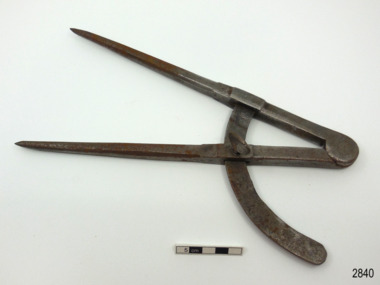 Flagstaff Hill Maritime Museum and Village
Instrument - Compass, late 19th to early 20th century
... Street Warrnambool great-ocean-road This large compass is well made. It is now pitted and scratched, indication much use. Compasses were used to measure and mark out the head of the barrel by coopers. Very large compasses were used by block, spar and pump makers to help shave off angles left by axes and other tools on mast sides. Also they were used by blacksmiths in their work draftsmen, carpenters, engineers and navigators ...This large compass is well made. It is now pitted and scratched, indication much use. Compasses were used to measure and mark out the head of the barrel by coopers. Very large compasses were used by block, spar and pump makers to help shave off angles left by axes and other tools on mast sides. Also they were used by blacksmiths in their work draftsmen, carpenters, engineers and navigators.This compass is an example of a drawing instrument that could have been used in the 19th and early 20th century by coopers and blacksmiths as well as navigators and ship smiths.Compass; large metal compass, 90-degree angle, two pointed arms hinged at the top. Inscription on the top of one arm.Stamped into the metal " J J E " ( or J J F )flagstaff hill, warrnambool, maritime village, maritime museum, flagstaff hill maritime museum & village, shipwreck coast, great ocean road, compass, drawing instrument, measuring instrument, scientific instrument, draftsman, technical drawing, navigation, engineering, blacksmith, cooper, plumber -
 Flagstaff Hill Maritime Museum and Village
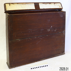
Container - Chart Case, Late 19th to early 20th centuries
... Street Warrnambool great-ocean-road This case was donated along with the contents of over 60 navigational charts for locations all over the world. The narrow box is built to keep the charts in order and easily accessible on board a vessel. The chart case is a rare example of a container used on board a vessel for the storage and protection of navigational charts. It represents the type of equipment used by the navigator ...This case was donated along with the contents of over 60 navigational charts for locations all over the world. The narrow box is built to keep the charts in order and easily accessible on board a vessel. The chart case is a rare example of a container used on board a vessel for the storage and protection of navigational charts. It represents the type of equipment used by the navigator of a seafaring vessel. The charts within the case represent the places to which the vessel travelled.Chart case (or map case), wooden, has hinged opening at top. Front of case folds down and has a hook closure. It contained 65 British Admiralty navigational charts, which are listed and stored separately. (See separate items 2928.2 to 2928.66)There is a hand written name on the back of the case.flagstaff hill, warrnambool, shipwrecked coast, flagstaff hill maritime museum, maritime museum, shipwreck coast, flagstaff hill maritime village, great ocean road, map case, chart case, map box, chart box, british admiralty charts, navigational charts, hydrographer charts, navigation, ship equipment -
 Flagstaff Hill Maritime Museum and Village
Document - Chart, Admiralty Office, Port Phillip, 1899
... Flagstaff Hill Maritime Museum and Village 89 Merri Street Warrnambool great-ocean-road Accurate charts were imperative for sea farers to sail their vessels safely from one side of the world to another. The British Admiralty published many charts and updated them frequently. Specialists were employed to gather information such as depth soundings to give the navigator ...Accurate charts were imperative for sea farers to sail their vessels safely from one side of the world to another. The British Admiralty published many charts and updated them frequently. Specialists were employed to gather information such as depth soundings to give the navigator as many helps as possible. At regular intervals the charts had to be updated with the amount of adjustment needed to a compass to allow for magnetic variation.This chart is significant for its association with incoming and outgoin ships for trade and passengers in the late 19th century.Admiralty Chart of Port Phillip, Victoria, South Coast of Australia. It shows navigation buoys, lighthouses, tides and money other details. It was surveyed by Commander Henry L. Cox R.N. in 1864. Published by Admiralty August 19th 1865. Corrections were made by Staff Commander E.J. Stanley R.N. in 1874. The West Channel was surveyed b J.B. Mason , Engineer, in 1899. Published and cartographed in Admiralty, London, England in 1897, supervised by Capt G H Richards R N Hydrographer. Chart was updated in 1899. Sold by W D Potter Agent for Admiralty Charts 145 minorities.Printed: "Port Phillip" "Australia - South Coast, Victoria"flagstaff hill, warrnambool, maritime-museum, flagstaff hill maritime museum & village, shipwreck coast, chart, australia, south coast, port phillip, admiralty, 1899, navigation, cartography, cartographer -
 Flagstaff Hill Maritime Museum and Village
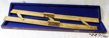
Parallel Rule, 1947-1950
... Flagstaff Hill Maritime Museum and Village 89 Merri Street Warrnambool great-ocean-road Navigators use parallel rule with maps and charts for plotting a specific course on a chart. ...Navigators use parallel rule with maps and charts for plotting a specific course on a chart. One long edge is used with the compass rose on the chart, aligning the centre of the rose with the desired direction around the edge of the rose. The compass bars are then ‘walked’ in and out across the map to the desired location so that lines can be plotted to represent the direction to be travelled. Kelvin Company History: The origins of the company lie in the highly successful and strictly informal relationship between William Thomson (1824-1907), Professor of Natural Philosophy at Glasgow University from 1846-1899 and James White, a Glasgow optical maker. James White (1824-1884) founded the firm of James White, an optical instrument maker in Glasgow in 1850 and was involved in supplying and mending apparatus for Thomson university laboratory and working with him on experimental constructions. White was declared bankrupt in August 1861 and released several months later. In 1870, White was largely responsible for equipping William Thomson laboratory in the new University premises at Gilmore hill. From 1876, he was producing accurate compasses for metal ships to Thomson design during this period and this became an important part of his business in the last years of his life. He was also involved in the production of sophisticated sounding machinery that Thomson had designed to address problems encountered laying cables at sea, helping to make possible the first transatlantic cable connection. At the same time, he continued to make a whole range of more conventional instruments such as telescopes, microscopes and surveying equipment. White's association with Thomson continued until he died. After his death, his business continued under the same name, being administered by Matthew Edwards until 1891 when he left to set up his own company. Thomson who became Sir William Thomson and then Baron Kelvin of Largs in 1892, continued to maintain his interest in the business after James White's death in 1884, raising most of the capital needed to construct and equip new workshops in Cambridge Street, Glasgow. At these premises, the company continued to make the compass Thomson had designed during the 1870s and to supply it in some quantity, especially to the Admiralty. At the same time, the firm became increasingly involved in the design, production and sale of electrical apparatus. In 1899, Lord Kelvin resigned from his University chair and became, in 1900, a director in the newly formed limited liability company Kelvin & James White Ltd which had acquired the business of James White. At the same time Kelvin's nephew, James Thomson Bottomley (1845-1926), joined the firm. In 1904, a London branch office was opened which by 1915 had become known as Kelvin, White & Hutton Ltd. Kelvin & James White Ltd underwent a further change of name in 1913, becoming Kelvin Bottomley & Baird Ltd. Hughes Company History: Henry Hughes & Sons were founded in 1838 in London as a maker of chronographic and scientific instruments. The firm was incorporated as “Henry Hughes & Sons Ltd” in 1903. In 1923, the company produced its first recording echo sounder and in 1935 a controlling interest in the company was acquired by S Smith & Son Ltd resulting in the development and production of marine and aircraft instruments. Following the London office's destruction in the Blitz of 1941, a collaboration was entered into with Kelvin, Bottomley & Baird Ltd resulting in the establishing “Marine Instruments Ltd”. Following the formal amalgamation of Kelvin, Bottomley & Baird Ltd and Henry Hughes & Sons Ltd in 1947 to form Kelvin & Hughes Ltd. Marine Instruments Ltd then acted as regional agents in the UK for Kelvin & Hughes Ltd who were essentially now a part of Smith's Industries Ltd founded in 1944 and the successors of S Smith & Son Ltd. Kelvin & Hughes Ltd went on to develop various marine radar and echo sounders supplying the Ministry of Transport, and later the Ministry of Defence. The firm was liquidated in 1966 but the name was continued as Kelvin Hughes, a division of the Smiths Group. In 2002, Kelvin Hughes continues to produce and develop marine instruments for commercial and military. This model parallel map ruler is a good example of the commercial diversity of navigational instruments made by Kelvin & Hughes after World War II. It was made in numbers for use by shipping after the second world war and is not particularly rare or significant for it's type. Also it was made no earlier than 1947 as the firms of Kelvin, Bottomley & Baird Ltd and Henry Hughes & Sons Ltd who took over from Smith & Sons were not amalgamated until 1947. It can therefor be assumed that this ruler was made during the company's transitional period to Kelvin & Hughes from Smith Industries Ltd.Brass parallel rule in wooden box with blue felt lining.Rule inscribed on front "Kelvin & Hughes Ltd" " Made in Great Britain"flagstaff hill, warrnambool, shipwrecked-coast, flagstaff-hill, flagstaff-hill-maritime-museum, maritime-museum, shipwreck-coast, flagstaff-hill-maritime-village, parallel rule, kelvin & hughes ltd, map ruler, plot direction, navigation, maps, echo sounder, kelvin & james white, lord kelvin, baron kelvin of largs, scientific instrument -
 Marysville & District Historical Society
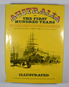
Book, IPC Books Pty Limited, Australia-The First Hundred Years-Being a facsimile of Volumes I & II of the Picturesque Atlas of Australia-1888, 1886
... Marysville & District Historical Society 39 Darwin Street Marysville yarra-valley-and-the-dandenong-ranges The Picturesque Atlas was designed to give a graphic and summarised conception of Australasian history and life from the days of the earliest Portuguese, Spanish, Dutch, English and French navigators to the 1880's, embracing such salient events as the landing of Captain Cook in 1770. the discoveries of voyagers, explorers an pioneer missionaries; the founding of the different colonies; the establishment of representative government and the marvellous political, commercial and social development which characterises the people of Australia. history australia explorers voyagers missionaries politics commercial development social development The Picturesque Atlas was designed to give a graphic and summarised conception of Australasian history and life from the days of the earliest Portuguese, Spanish, Dutch, English and French navigators to the 1880's, embracing such salient events as the landing of Captain Cook in 1770. the discoveries of voyagers, explorers an pioneer missionaries; the founding of the different colonies; the establishment of representative government and the marvellous political, commercial and social development which characterises the people of Australia. ...The Picturesque Atlas was designed to give a graphic and summarised conception of Australasian history and life from the days of the earliest Portuguese, Spanish, Dutch, English and French navigators to the 1880's, embracing such salient events as the landing of Captain Cook in 1770. the discoveries of voyagers, explorers an pioneer missionaries; the founding of the different colonies; the establishment of representative government and the marvellous political, commercial and social development which characterises the people of Australia.Dust cover has an illustration depicting Circular Quay, West Side in the early days of Australia.non-fictionThe Picturesque Atlas was designed to give a graphic and summarised conception of Australasian history and life from the days of the earliest Portuguese, Spanish, Dutch, English and French navigators to the 1880's, embracing such salient events as the landing of Captain Cook in 1770. the discoveries of voyagers, explorers an pioneer missionaries; the founding of the different colonies; the establishment of representative government and the marvellous political, commercial and social development which characterises the people of Australia.history, australia, explorers, voyagers, missionaries, politics, commercial development, social development -
 Tatura Irrigation & Wartime Camps Museum
Photograph, The Bush Pilot - Peter Mueller
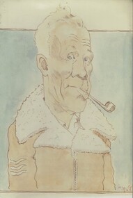
... Tatura Irrigation & Wartime Camps Museum 49 Hogan Street Tatura the-murray The sketch was drawn byartist Hans von Gruenewaldt. The pilot is Peter Mueller, a Luftwaffe navigator/bomber in North Africa in WW2. ...The sketch was drawn byartist Hans von Gruenewaldt. The pilot is Peter Mueller, a Luftwaffe navigator/bomber in North Africa in WW2. Both men were POW's in Camp 13 during WW2. Colour photograph copy of a sketch (on foam backing) of a grey haired man wearing a brown wool lined flight jacket with wool collar. He is holding a pipe in his mouth. 3 stripes (sergeant) on his sleeve.hans von gruenewaldt, camp 13 artists, camp 13 internees, peter mueller -
Clunes Museum
Book, PAUL HAMLYN PTL LTD, AUSTRALIA - THE FIRST HUNDRED YEARS, 1978
... Clunes Museum 36 Fraser Street enter building through Collins Place Clunes goldfields THE FIRST HUNDRED YEARS PICTURESQUE ATLAS OF AUSTRALIA THE PICTURESQUE ATLAS WAS DESINGED TO GIVE A GRAPHIC AND SUMMARISED CONCEPTION OF AUSTRALASIAN HISTORY AND LIFE FROM THE OF THE EARLIEST PRTUGUESE, SPANISH, DUTCH, ENGLISH AND FRENCH NAVIGATORS... ...THE PICTURESQUE ATLAS WAS DESINGED TO GIVE A GRAPHIC AND SUMMARISED CONCEPTION OF AUSTRALASIAN HISTORY AND LIFE FROM THE OF THE EARLIEST PRTUGUESE, SPANISH, DUTCH, ENGLISH AND FRENCH NAVIGATORS...YELLOW PAPERBACK BOOK WITH ADHESIVE PLASTIC COVER. ON THE COVER FEATURES A DRAWING OF CIRCULAR QUAY. WEST SIDE. "BEING A FACSIMILE OF VOLUMES 1 AND 2 OF THE PICTURESQUE ATLAS OF AUSTRALASIA 1888", EDITED BY THE HON. ANDREW GARRAN. M.A., L.L.D/M.L.C. ILLUSTRATED WITH 700 ENGRAVINGS ON STEEL AND WOOD 530 PAGES + 26 PAGES OF FULL-PAGE ENGRAVINGSnon-fictionTHE PICTURESQUE ATLAS WAS DESINGED TO GIVE A GRAPHIC AND SUMMARISED CONCEPTION OF AUSTRALASIAN HISTORY AND LIFE FROM THE OF THE EARLIEST PRTUGUESE, SPANISH, DUTCH, ENGLISH AND FRENCH NAVIGATORS...the first hundred years, picturesque atlas of australia -
 Uniting Church Archives - Synod of Victoria
Photograph, Undated, c. 1970s
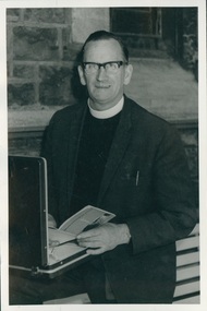
... Navigator for Bomber Command. Was recalled in 1943 and began his ministry in the Woomelang Circuit, then at Mitiamo 1947-1950; Port Fairy 1950-52; Nathalia 1952-54. He left the ministry and bought a small farm near Bendigo. After 18 mths he started preaching at Mckenzie Street...Street Malvern East melbourne Born on the West Coast of Tasmania. Became a teacher inTasmania in the early 1930. He married Emily Ferguson, a presbyterian girl, but felt a calling to the Methodist Church. John went to Underbool in Vic in 1939. Joined the RAAF in 1942 and trained as a Navigator ...Born on the West Coast of Tasmania. Became a teacher inTasmania in the early 1930. He married Emily Ferguson, a presbyterian girl, but felt a calling to the Methodist Church. John went to Underbool in Vic in 1939. Joined the RAAF in 1942 and trained as a Navigator for Bomber Command. Was recalled in 1943 and began his ministry in the Woomelang Circuit, then at Mitiamo 1947-1950; Port Fairy 1950-52; Nathalia 1952-54. He left the ministry and bought a small farm near Bendigo. After 18 mths he started preaching at Mckenzie Street Methodist church with the title Pastor. In 1958 he was recalled to the ministry and served at Morwell. He was also chaplain to Morwell River Prison, Newport West, Coburg, Milan Italy and Finally at Moonee Ponds where he retired in 1978. After retirement he did supply work in places such as Sea Lake, Heathcote, Warragul and Quirindi NSW. John died on 25 July 2000. B & W photograph of Rev. John Adamthwaite standing in front of an open briefcase.john adamthwaite, methodist, minister -
 Kew Historical Society Inc
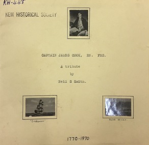
Booklet, Neil S Smith, Captain James Cook, RM, FRNS, 1970
... Kew Historical Society Inc Kew Court House 188 High Street Kew melbourne Monograph on Captain James Cook written by Neil S Smith. captain james cook british navigators Inside cover (handwritten): "Kew Historical Society / a token of appreciation for a / pleasant vistit. / Neil S. ...Monograph on Captain James Cook written by Neil S Smith.16 page typed and reproduced monograph on Capn James Cook, written by Neil S. Smith. The monograph has stapled brown paper covers with photographs attached. Inside cover (handwritten): "Kew Historical Society / a token of appreciation for a / pleasant vistit. / Neil S. Smith"captain james cook, british navigators -
 Melbourne Legacy
Newspaper - Document, article, Lucky takes charge of Legacy, 1997
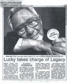
... Street Melbourne melbourne An article from the Herald Sun on March 24, 1997. It tells how Brian 'Lucky' Luscombe is taking over as president of Legacy. It gives some biographical details. Including that he was a former president of Clayton RSL, and that he served in World War II as a navigator ...An article from the Herald Sun on March 24, 1997. It tells how Brian 'Lucky' Luscombe is taking over as president of Legacy. It gives some biographical details. Including that he was a former president of Clayton RSL, and that he served in World War II as a navigator with 463 RAAF Lancaster squadron and flew missions including the raid over Dresden. His nickname 'Lucky' came after a near miss during training in Tasmania when his plane came close to crashing and somebody said 'Here comes Lucky Luscombe' and the name stuck. It also says Legacy were approaching their 75th Anniversary and were currently caring for 120,00 widows around Australia. It is a nice introduction to the man taking over as President in 1997. Until 2004 a Legatee would only serve as President for a one year term, starting each March.A record that the changes at Legacy were published in the newspapers, both to inform the public and also promote recognition of Legacy's work.Newspaper article with a black and white photo of a Brian Luscombe.past presidents, lucky luscombe -
 St Kilda Historical Society
Photograph, Captain James Cook statue, St Kilda - images collection, Photographs taken c 1991 (set)
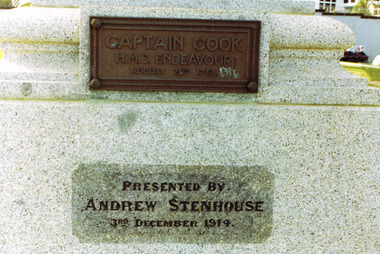
... Street St Kilda melbourne Statue presented by Andrew Stenhouse, 3 December 1914. Donated by Mr Andrew Stenhouse, a retired contractor who lived at Beaconsfield Parade, St Kilda, he was interested in the reclamation of the foreshore in front of his dwelling Captain James Cook FRS (1728-1779) was a British explorer, navigator, cartographer, and captain in the Royal Navy. ...Statue presented by Andrew Stenhouse, 3 December 1914. Donated by Mr Andrew Stenhouse, a retired contractor who lived at Beaconsfield Parade, St Kilda, he was interested in the reclamation of the foreshore in front of his dwelling Captain James Cook FRS (1728-1779) was a British explorer, navigator, cartographer, and captain in the Royal Navy. During three voyages to the Pacific Ocean he achieved the first recorded European contact with the eastern coastline of Australia and the Hawaiian Islands, and the first recorded circumnavigation of New Zealand. He was killed in the Hawaiian Islands in 1779. The statue appears to have been the first monument erected to him in Victoria and is a replica of one in Whitby, England. It was unveiled on Monday December 7th, 1914 by the Governor of Victoria, Sir Arthur Stanley in front of Commonwealth and State dignitaries and hundreds of St Kilda residents. It was donated by philanthropist Mr. Andrew Stenhouse, a member of the St. Kilda Shore committee.colour photograph unmountedCaptain Cook HMS Endeavour, August 26, 1768. Presented by Andrew Stenhouse, 3rd December 1914. A plaque on the rear of the pedestal (no image provided) lists the crew of the Endeavour. st kilda, captain cook, plaques, catani gardens, captain cook statue, andrew stenhouse -
 Ringwood RSL Sub-Branch
Badges- RAAF
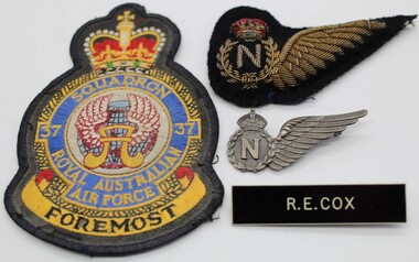
... Ringwood RSL Sub-Branch 16 Station Street Ringwood melbourne Khaki Cloth Rank badges x 8. / Blue cloth rank badges x 2./ 37 Squadron Blazer Pocket./ Navigators Half Wing, cloth and bullion. ...Khaki Cloth Rank badges x 8. / Blue cloth rank badges x 2./ 37 Squadron Blazer Pocket./ Navigators Half Wing, cloth and bullion. Navigators metal half wing./ 3 x Name Badge R.E.Cox -
 Melbourne Legacy
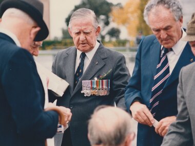
Photograph, Anzac commemoration for students 1987, 1987
... Street Melbourne melbourne Photo of Legatee Ian Richardson at the students Anzac commemoration ceremony on 28 April 1987. His medals include the Distinguished Flying Cross and the Distinguished Flying Medal. He appears to be holding a tray of rosemary that Legacy Widows prepare for Anzac Day services. Was found in an envelope marked "For Melbourne Legacy. Anzac Day Parade featuring Legacy Lads.' From TROVE: an article from June 1944 mentions him receiving his DFM for 'SKILL AND COURAGE Flying-Officer Richardson, a navigator ...Photo of Legatee Ian Richardson at the students Anzac commemoration ceremony on 28 April 1987. His medals include the Distinguished Flying Cross and the Distinguished Flying Medal. He appears to be holding a tray of rosemary that Legacy Widows prepare for Anzac Day services. Was found in an envelope marked "For Melbourne Legacy. Anzac Day Parade featuring Legacy Lads.' From TROVE: an article from June 1944 mentions him receiving his DFM for 'SKILL AND COURAGE Flying-Officer Richardson, a navigator, has completed a second operational tour. He is an exceptional navigator, whose skill and coolness in time of stress have inspired confidence among his crew.' According to Forces War Records UK, the Distinguished Flying Cross (DFC) is awarded to Officers and Warrant officers for "an act or acts of valour and courage or devotion to duty performed whilst flying in active operations against the enemy". The Distinguished Flying Medal was the other ranks' equivalent to the Distinguished Flying Cross.A record of Legatees attending the student ceremony that was held just prior to Anzac Day. Also that their medals show a history of distinguished service.Photo of Ian Richardson at the students Anzac ceremony in 1987.Handwritten on the back 'Ian Richardson, Legacy Shrine Ceremony for children 28.4.87 DFC, DFM' in black pen.anzac commemoration for students, legatee, ian richardson