Showing 444 items matching "nepean"
-
 Glen Eira Historical Society
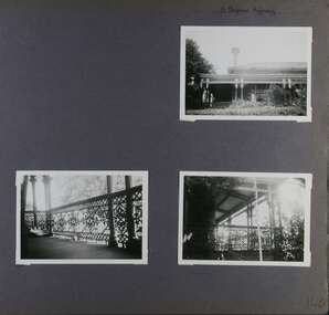
Album - Album page, 31 Nepean Highway, Circa 1972
... 31 Nepean Highway...Page 140 of Photograph Album with three (landscape) photographs of Roseneath on Nepean Highway. ...Handwritten: 31 Nepean Highway [top right] / 140 [bottom right]...31 Nepean Highway, Elsternwick, Melbourne, Victoria, Australia...Victorian Heritage Database - HO48 - 31 Nepean Highway Elsternwick https://vhd.heritagecouncil.vic.gov.au/places/35531 (at 15/08/2021) "Roseneath" at 31 Point Nepean Road is a bi-chromatic Italianate villa built for William Millar in 1874. ...This photograph is part of the Caulfield Historical Album 1972. This album was created in approximately 1972 as part of a project by the Caulfield Historical Society to assist in identifying buildings worthy of preservation. The album is related to a Survey the Caulfield Historical Society developed in collaboration with the National Trust of Australia (Victoria) and Caulfield City Council to identify historic buildings within the City of Caulfield that warranted the protection of a National Trust Classification. Principal photographer thought to be Trevor Hart, member of Caulfield Historical Society. Most photographs were taken between 1966-1972 with a small number of photographs being older and from unknown sources. All photographs are black and white except where stated, with 386 photographs over 198 pages. Victorian Heritage Database - HO48 - 31 Nepean Highway Elsternwick https://vhd.heritagecouncil.vic.gov.au/places/35531 (at 15/08/2021) "Roseneath" at 31 Point Nepean Road is a bi-chromatic Italianate villa built for William Millar in 1874. It is aesthetically and historically important. "Roseneath's aesthetic value derives from its survival as a substantially intact bi-chromatic brick villa, distinguished by the symmetrical north and south facing bays and by its spacious grounds. Its historical value rests on its comparatively early date and link with Shire councillor William Millar. The choice of bi-chromatic brick, which was highly fashionable at the time, is also of note. "Roseneath" compares with "Cumbernauld" (pre 1872) at 504 Hawthorn Road and "Glenmoore" (1870) at 1 St Georges Road.Page 140 of Photograph Album with three (landscape) photographs of Roseneath on Nepean Highway. Handwritten: 31 Nepean Highway [top right] / 140 [bottom right]trevor hart, verandah, chimneys, porch, decorative brackets, single storey, cast iron columns, return verandah, garden, nepean highway, roseneath, italianate, 1870's, elsternwick, cast iron work, victorian style, polychrome bricks, william millar, slate roofs, brick houses, house names -
 Ballarat Heritage Services
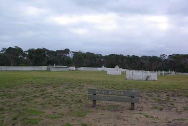
Photograph - Photograph - Colour, Clare Gervasoni, Point Nepean Cemetery, 24/05/2011
... Point Nepean Cemetery...Colour photographs of the Potin Nepean Cemetery....Port Nepean, Victoria, Australia...Point Nepean Cemetery Photograph Photograph - Colour Clare Gervasoni ...Colour photographs of the Potin Nepean Cemetery.point nepean, point nepean cemetery, jennie o'hara, john o'hara, edjar james taylor, frederick hicowe, george walker, edward skelton, harriet skelton, hannah ford, margaret ford, peter purves, elizabeth bowie, robert bowie, edward pike, john fercus, mary jane fercus, charles hugh fercus, ticonderoga, helen mcrae, sarah mcdonald, angus mcdonald, margaret mcdonald, william henry boyle, quarantine station -
 Monbulk RSL Sub Branch
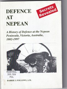
Book, Barrie I Follows, Defence at Nepean: A history of defence at the Nepean peninsula, Victoria, 1802-1997, 2011
... Defence at Nepean: A history of defence at the Nepean peninsula, Victoria, 1802-1997......Nepean historical society...Murray from the 'Lady Nelson' up until 1997. ill., facsims., maps, ports. p.126. Defence at Nepean: A history of defence at the Nepean peninsula, Victoria, 1802-1997 Book Barrie I Follows Nepean historical society ...A history of military activities at and relating to the Point Nepean area from the firing of the first shot in this area in 1802 by Lt. Murray from the 'Lady Nelson' up until 1997.ill., facsims., maps, ports. p.126.non-fictionA history of military activities at and relating to the Point Nepean area from the firing of the first shot in this area in 1802 by Lt. Murray from the 'Lady Nelson' up until 1997. fortifications - victoria - nepean peninsula - history, coast defences - victoria - historia -
 City of Kingston
Photograph - Digital image, Black and white, Roads - Junction of Nepean Highway and South Road, c. 1950
... Roads - Junction of Nepean Highway and South Road...Junction of Nepean Highway and South Road, Moorabbin - Moorabbin Hotel on right. ...Black and white image of Nepean Highway and South Road junction point of view from Kingston Town Hall...Printed in black text a round white sticker: 234 Handwritten in red ink 80% Yellow post it note written in blue ink: CHAP 7 234 / - Nepean Hwy + South Road...Shops in centre demolished for road widening in 1980's Nepean Highway South Road Moorabbin Moorabbin Hotel Printed in black text a round white sticker: 234 Handwritten in red ink 80% Yellow post it note written in blue ink: CHAP 7 234 / - Nepean Hwy + South Road Black and white image of Nepean Highway and South Road junction point of view from Kingston Town Hall Roads - Junction of Nepean Highway and South Road Photograph Digital image, Black and white ...Junction of Nepean Highway and South Road, Moorabbin - Moorabbin Hotel on right. Shops in centre demolished for road widening in 1980'sBlack and white image of Nepean Highway and South Road junction point of view from Kingston Town HallPrinted in black text a round white sticker: 234 Handwritten in red ink 80% Yellow post it note written in blue ink: CHAP 7 234 / - Nepean Hwy + South Roadnepean highway, south road, moorabbin, moorabbin hotel -
 Chelsea & District Historical Society Inc
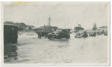
Photograph - Chelsea Flood December 1934, Point Nepean Road (Nepean Highway)
... Point Nepean Road (Nepean Highway)...Black and white photo of flood waters across Point Nepean Road (now Nepean Highway). Cars and trucks are driving through the water....Chelsea & District Historical Society Inc The Chelsea Activity Hub 3-5 Showers Ave Chelsea 3196 melbourne In December 1934, 700 houses were inundated with water, when the Dandenong Creek and Patterson River broke their banks. flood chelsea Dandenong Creek Nepean Highway Point Nepean Road Black and white photo of flood waters across Point Nepean Road (now Nepean Highway). ...In December 1934, 700 houses were inundated with water, when the Dandenong Creek and Patterson River broke their banks.Black and white photo of flood waters across Point Nepean Road (now Nepean Highway). Cars and trucks are driving through the water.flood, chelsea, dandenong creek, nepean highway, point nepean road -
 Whitehorse Historical Society Inc.
document - Map, Point Nepean, 1969
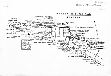
... Point Nepean...Map of Point Nepean showing historical sites, issued by the Nepean Historical Society, 1969....Whitehorse Historical Society Inc. 2-10 Deep Creek Road Mitcham melbourne point nepean victoria nepean historical society Map of Point Nepean showing historical sites, issued by the Nepean Historical Society, 1969. ...Map of Point Nepean showing historical sites, issued by the Nepean Historical Society, 1969.point nepean, victoria, nepean historical society -
 Melbourne Tram Museum
Letter, Australian Electric Traction Association (AETA), "Proposal to build a tramline down Nepean Highway to Southland", May. 1977
... "Proposal to build a tramline down Nepean Highway to Southland"...The Nepean Highway was being widened at the time. ...The Nepean Highway was being widened at the time. ...Letter with supplementary document - "Proposal to build a tramline down Nepean Highway to Southland", advocating residents support a study into a possible tram line to Southland, May 1977. The Nepean Highway was being widened at the time. Produced by the AETA. Printed by duplicating process on white foolscap paper.trams, tramways, public transport, mmtb, proposals, moorabbin -
 City of Kingston
Photograph - Black and white, Nepean Highway, Cheltenham, c. 1925
... Nepean Highway, Cheltenham...Black and white image of the Cheltenham Post Office, Mechanics Institute Hall and Billiard Room looking across the Nepean Highway....City of Kingston Parkdale Library 96 Parkers Road, Parkdale Parkdale Black and white image of the Cheltenham Post Office, Mechanics Institute Hall and Billiard Room looking across the Nepean Highway. Nepean Highway, Cheltenham Photograph Black and white ...Black and white image of the Cheltenham Post Office, Mechanics Institute Hall and Billiard Room looking across the Nepean Highway. -
 Greensborough Historical Society
Folder of documents, Nepean Street - fact or fiction?, by Peter Simmenauer, 2018_09
... Nepean Street - fact or fiction?, by Peter Simmenauer...Record of ownership of 216 Nepean Street Greensborough 1916-1997, Grace Park area...Greensborough Historical Society 34A Glenauburn Road Lower Plenty Lower Plenty melbourne Record of ownership of 216 Nepean Street Greensborough 1916-1997, Grace Park area nepean street greensborough grace park Photocopies of four Certificates of Title and other land documents, with summary of land ownership 1916-1997 Nepean Street - fact or fiction? ...Record of ownership of 216 Nepean Street Greensborough 1916-1997, Grace Park areaPhotocopies of four Certificates of Title and other land documents, with summary of land ownership 1916-1997nepean street greensborough, grace park -
 Greensborough Historical Society
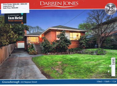
Advertising Leaflet, Darren Jones, 222 Nepean Street Greensborough, 23/09/2017
... 222 Nepean Street Greensborough...222 Nepean Street Greensborough. Three bedroom house, sold for $920,000 in September 2017. ...Greensborough Historical Society 34A Glenauburn Road Lower Plenty Lower Plenty melbourne 222 Nepean Street Greensborough. Three bedroom house, sold for $920,000 in September 2017. nepean street greensborough Real estate advertising leaflet, 1 sheet, printed in colour both sides. 222 Nepean Street Greensborough Advertising Leaflet Darren Jones ...222 Nepean Street Greensborough. Three bedroom house, sold for $920,000 in September 2017. Real estate advertising leaflet, 1 sheet, printed in colour both sides. nepean street greensborough -
 Greensborough Historical Society
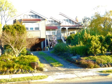
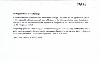
Document, Peter Simmenauer, 208 Nepean Street Greensborough, 2020
... 208 Nepean Street Greensborough...History of a house built in Nepean Street in the 1960s by its owner, and still occupied by the family in 2020....Greensborough Historical Society 34A Glenauburn Road Lower Plenty Lower Plenty melbourne History of a house built in Nepean Street in the 1960s by its owner, and still occupied by the family in 2020. whan family nepean street greensborough 1 p. typescript, with two colour photocopies 208 Nepean Street Greensborough Document Document Peter Simmenauer ...History of a house built in Nepean Street in the 1960s by its owner, and still occupied by the family in 2020.1 p. typescript, with two colour photocopieswhan family, nepean street greensborough -
 Greensborough Historical Society
Folder of Documents, Nepean Street Greensborough...Purchasers Walter Edwin Kell and others, 2019_
... Nepean Street Greensborough...Purchasers Walter Edwin Kell and others...Record of purchases of land on the north side of Nepean Street Greensborough by Walter Edwin Kell and others....Greensborough Historical Society 34A Glenauburn Road Lower Plenty Lower Plenty melbourne Record of purchases of land on the north side of Nepean Street Greensborough by Walter Edwin Kell and others. nepean street greensborough grace park kell family jackson family Folder containing Certiificates of Title, documents and photographs Nepean Street Greensborough...Purchasers Walter Edwin Kell and others Folder of Documents Peter Simmenauer Peter Simmenauer ...Record of purchases of land on the north side of Nepean Street Greensborough by Walter Edwin Kell and others.Folder containing Certiificates of Title, documents and photographsnepean street greensborough, grace park, kell family, jackson family -
 Greensborough Historical Society
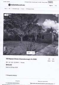
Flyer - Advertisement, Morrison Kleeman Real Estate, 105 Nepean Street, Greensborough, 2025
... 105 Nepean Street, Greensborough...Advertisement of Sale of 105 Nepean Street, Greensborough by Morrison Kleeman. ...Advertisement of Sale of 105 Nepean Street, Greensborough by Morrison Kleeman. ...Advertisement of Sale of 105 Nepean Street, Greensborough by Morrison Kleeman. Property sold 20/09/2025 for $842,500.Copy of webpage: Black photo and black textmorrison kleeman, nepean street greensborough -
 Greensborough Historical Society
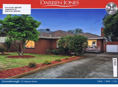
Advertising Leaflet, Darren Jones, 101 Nepean Street Greensborough, 02/12/2017
... 101 Nepean Street Greensborough...101 Nepean Street Greensborough. Four bedroom house, sold for $830,000 in December 2017. ...Previous sales: July 2001, $434,000. nepean street greensborough Real estate advertising leaflet, 1 sheet, printed in colour both sides. 101 Nepean Street Greensborough Advertising Leaflet Darren Jones ...101 Nepean Street Greensborough. Four bedroom house, sold for $830,000 in December 2017. Previous sales: July 2001, $434,000.Real estate advertising leaflet, 1 sheet, printed in colour both sides. nepean street greensborough -
 Phillip Island and District Historical Society Inc.
Book, Nepean Historical Society, Peninsula story. Book 1, Sorrento and Portsea - yesterday, 1972
... Nepean Historical Society...Book 1, Sorrento and Portsea - yesterday Book Nepean Historical Society The Society ...sorrento, victoria, history, portsea -
 Robin Boyd Foundation
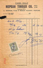
Document - Invoice, Nepean Timber, c. 1958
... Nepean Timber...Walsh St construction John Murphy Invoice to John Murphy Document Invoice Nepean Timber ...This document is owned by the Murphy family and was provided to the Robin Boyd Foundation for digitisation.Invoice to John Murphywalsh st construction, john murphy -
 Greensborough Historical Society
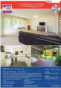
Advertising Leaflet, 4/94-100 Nepean Street Watsonia, 26/05/2018
... 4/94-100 Nepean Street Watsonia...4/94-100 Nepean Street Watsonia. 3 bedroom 2 storey terrace home, auctioned 26 May 2018, P.I. $555,000, sold July 2018, no price information...Greensborough Historical Society 34A Glenauburn Road Lower Plenty Lower Plenty melbourne 4/94-100 Nepean Street Watsonia. 3 bedroom 2 storey terrace home, auctioned 26 May 2018, P.I. $555,000, sold July 2018, no price information nepean street watsonia Real estate advertising leaflet, 1 sheet, printed in colour both sides 4/94-100 Nepean Street Watsonia Advertising Leaflet Darren Jones ...4/94-100 Nepean Street Watsonia. 3 bedroom 2 storey terrace home, auctioned 26 May 2018, P.I. $555,000, sold July 2018, no price informationReal estate advertising leaflet, 1 sheet, printed in colour both sidesnepean street watsonia -
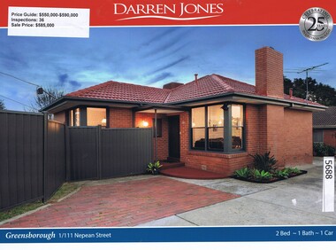 Greensborough Historical Society
Advertising Leaflet, Darren Jones, 1/111 Nepean Street Greensborough, 15/07/2017
... 1/111 Nepean Street Greensborough...1/111 Nepean Street Greensborough. Two bedroom unit, sold for $585,000 in July 2017. ...Previous sales: April 2010, $330,000, August 2006, $222,500 and August 2002, $186,000. nepean street greensborough Real estate advertising leaflet, 1 sheet, printed in colour both sides. 1/111 Nepean Street Greensborough Advertising Leaflet Darren Jones ...1/111 Nepean Street Greensborough. Two bedroom unit, sold for $585,000 in July 2017. Previous sales: April 2010, $330,000, August 2006, $222,500 and August 2002, $186,000.Real estate advertising leaflet, 1 sheet, printed in colour both sides. nepean street greensborough -
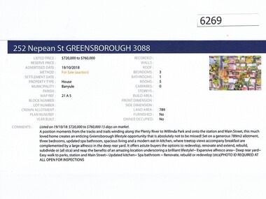 Greensborough Historical Society
Advertising Leaflet, Barry Plant Greensborough, 252 Nepean Street Greensborough, 19/10/2018
... 252 Nepean Street Greensborough...Real estate advertisement for 252 Nepean Street Greensborough, a 3 bedroom house. ...Previous sales: February 1977 for $42,850. nepean street greensborough Real estate advertisement black text and colour photograph 252 Nepean Street Greensborough Advertising Leaflet Barry Plant Greensborough ...Real estate advertisement for 252 Nepean Street Greensborough, a 3 bedroom house. Originally listed by Barry Plant, this house was sold on 05/12/2018 for $655,000. Previous sales: February 1977 for $42,850.Real estate advertisement black text and colour photographnepean street greensborough -
 Greensborough Historical Society
Prescription Folder, Diamond Village Discount Chemist, 2018_
... Opened in Diamond Village in January 2018, the Diamond Valley Discount Chemist is situated at 6/78 Nepean Street Greensborough...6/78 Nepean Street, Watsonia, Victoria, Australia...Greensborough Historical Society 34A Glenauburn Road Lower Plenty Lower Plenty melbourne Opened in Diamond Village in January 2018, the Diamond Valley Discount Chemist is situated at 6/78 Nepean Street Greensborough pharmacies nepean street greensborough Folder, printed in red and dark blue on white. ...Opened in Diamond Village in January 2018, the Diamond Valley Discount Chemist is situated at 6/78 Nepean Street GreensboroughFolder, printed in red and dark blue on white. Used to hold prescriptionspharmacies, nepean street greensborough -
 Greensborough Historical Society
Refrigerator magnet, Care Pharmacy, 2000c
... Name changed to Watsonia Compounding Pharmacy, 9/78 Nepean Street Watsonia 3087 (Diamond Village Shopping Centre)...78 Nepean Street, Watsonia...Greensborough Historical Society 34A Glenauburn Road Lower Plenty Lower Plenty melbourne Name changed to Watsonia Compounding Pharmacy, 9/78 Nepean Street Watsonia 3087 (Diamond Village Shopping Centre) pharmacies "Care Pharmacy", address, phone number, opening hours and email Refrigerator magnet, red, white and black print on blue Care Pharmacy Refrigerator magnet Care Pharmacy ...Name changed to Watsonia Compounding Pharmacy, 9/78 Nepean Street Watsonia 3087 (Diamond Village Shopping Centre)Refrigerator magnet, red, white and black print on blue"Care Pharmacy", address, phone number, opening hours and emailpharmacies -
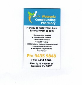 Greensborough Historical Society
Refrigerator Magnet, Watsonia Compounding Pharmacy, 2018_
... One of two pharmacies located in Diamond Village Shopping Centre Watsonia, the Watsonia Compounding Pharmacy is situated at 9/78 Nepean Street Watsonia...9/78 Nepean Street, Greensborough, Victoria, Australia...Greensborough Historical Society 34A Glenauburn Road Lower Plenty Lower Plenty melbourne One of two pharmacies located in Diamond Village Shopping Centre Watsonia, the Watsonia Compounding Pharmacy is situated at 9/78 Nepean Street Watsonia pharmacies nepean street watsonia Refrigerator magnet, printed in blue, orange, green and black on white Watsonia Compounding Pharmacy Refrigerator Magnet ...One of two pharmacies located in Diamond Village Shopping Centre Watsonia, the Watsonia Compounding Pharmacy is situated at 9/78 Nepean Street WatsoniaRefrigerator magnet, printed in blue, orange, green and black on whitepharmacies, nepean street watsonia -
![Pamphlet, Greensborough Secondary College Senior Campus 1991 [Gr8750], 1991_](/media/collectors/4f729f5697f83e03086015b8/items/598bb93821ea6919dc9e17bc/item-media/5992c3da21ea671398d0e5d5/item-fit-380x285.jpg?cb=6) Greensborough Historical Society
Greensborough Historical SocietyPamphlet, Greensborough Secondary College Senior Campus 1991 [Gr8750], 1991_
... The Senior Campus was located in Nepean Street, near the Junior Campus in Nell Street. ...Nepean St, Watsonia, Victoria, Australia...The Senior Campus was located in Nepean Street, near the Junior Campus in Nell Street. ...The College was established in 1990. The Senior Campus was located in Nepean Street, near the Junior Campus in Nell Street. This is an information flyer outlining the Senior Campus services.Printed in blue and black , with colour photographs 4 pages.greensborough secondary college -
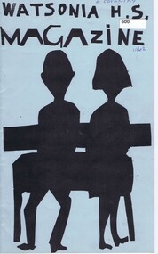 Greensborough Historical Society
School Magazine, Watsonia High School Magazine 1962, 1962_
... Watsonia High School has now moved to their own buildings in Nepean Street. ...Watsonia High School main office, Nepean Street , Greensborough, Shire of Diamond Valley, Victoria, 3088, Australia...Watsonia High School has now moved to their own buildings in Nepean Street. Annual record of teaching staff, students and events that took place over the year by using both photos and reports. ...Depicts events and attitudes, primarily of students as they go through their adolescent years in the early 1960's. Watsonia High School has now moved to their own buildings in Nepean Street. Annual record of teaching staff, students and events that took place over the year by using both photos and reports. Includes Roll Call section with names of all students.Note: This was the 1st Year of Watsonia's solo publication.20 Pages, Blue cover, Title in black with Illustration of students. Headmaster / Principal - Mr. L.G.MillerOwner's name on coverwatsonia high school -
 Eltham District Historical Society Inc
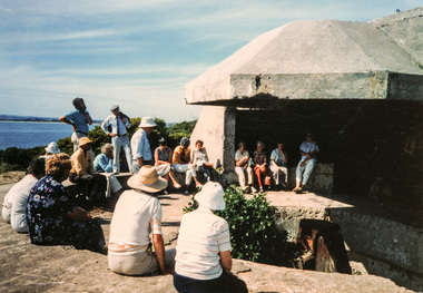
Photograph, Joh Ebeli, Point Nepean Gun Turret, Portsea and Sorrento, 1 December 1985, 01/12/1985
... Point Nepean Gun Turret, Portsea and Sorrento, 1 December 1985...He proved most informative and entertaining, particularly with regard to the Army and Quarantine Reserve at Point Nepean. We also visited the Museum at Sorrento and the site of the 1803 First Settlement. ...He proved most informative and entertaining, particularly with regard to the Army and Quarantine Reserve at Point Nepean. We also visited the Museum at Sorrento and the site of the 1803 First Settlement. ...[from EDHS Newsletter No. 46, January 1986:] Our bus trip to Portsea was considered by many to be one of the most enjoyable staged by the Society. Peter Collins of the Peninsula Historical Society travelled with us as a guide. He proved most informative and entertaining, particularly with regard to the Army and Quarantine Reserve at Point Nepean. We also visited the Museum at Sorrento and the site of the 1803 First Settlement. This was a long and tiring, but very rewarding, trip.Colour photographactivities, portsea, sorrento -
 City of Kingston
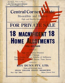
Pamphlet - Colour, Roy Dunn Pty. Ltd, Central Corner Estate Moorabbin and Highett, c. 1923
... Sales plan for land in the suburbs of Highett and Moorabbin, bordered by Point Nepean Road and Wickham Road East incorporating William Street...Incorporates a map of the estate bordered by Point Nepean Road and Wickham Road East, with subdivisions also available on both sides of William Street. ...Handwritten in blue pencil on subdivision plan: a tick is drawn on subdivisions 2-18 Handwritten in blue pencil on subdivision 6: a box with an x inside Handwritten in blue pencil on subdivisions 10 and 12: S Handwritten in black ink on front page: [indecipherable] / McKittricks Handwritten in grey pencil on rear page: McKilhick / Nepean Rd Handwritten in grey pencil on rear page upside down: 160000 / 15 8300 [crossed out] ...Incorporates a map of the estate bordered by Point Nepean Road and Wickham Road East, with subdivisions also available on both sides of William Street. ...Sales plan for land in the suburbs of Highett and Moorabbin, bordered by Point Nepean Road and Wickham Road East incorporating William StreetThe developing urban area of Highett and Moorabbin within the City of Kingston. This land sale pamphlet illustrates the subdivision of land within the municipality and the changing demographic of the district as new houses are constructed close to infrastructure.Colour pamphlet advertising for private sale land in the Central Corner Estate in Moorabbin and Highett. Incorporates a map of the estate bordered by Point Nepean Road and Wickham Road East, with subdivisions also available on both sides of William Street. Handwritten in blue pencil on subdivision plan: a tick is drawn on subdivisions 2-18 Handwritten in blue pencil on subdivision 6: a box with an x inside Handwritten in blue pencil on subdivisions 10 and 12: S Handwritten in black ink on front page: [indecipherable] / McKittricks Handwritten in grey pencil on rear page: McKilhick / Nepean Rd Handwritten in grey pencil on rear page upside down: 160000 / 15 8300 [crossed out] land sales, estate, highett, moorabbin -
 City of Kingston
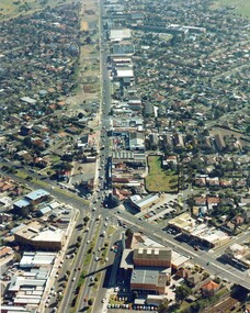
Photograph - Colour, c. 1982
... This aerial photograph of South Road and Nepean Highway, Moorabbin shows the area where houses and shops on the south side of the Nepean Highway have demolished for the widening of the highway. ...Colour photograph of an aerial view of South Road and Nepean Highway, Moorabbin. The image shows houses on the south side of the Nepean Highway that have demolished for widening of road. ...City of Kingston Parkdale Library 96 Parkers Road, Parkdale Parkdale This aerial photograph of South Road and Nepean Highway, Moorabbin shows the area where houses and shops on the south side of the Nepean Highway have demolished for the widening of the highway. ...This aerial photograph of South Road and Nepean Highway, Moorabbin shows the area where houses and shops on the south side of the Nepean Highway have demolished for the widening of the highway. The pressures of rapid urban development in Moorabbin and beyond, especially to the south of Moorabbin caused bottlenecks and delays, especially at the South Road and Nepean Highway intersection, hence the scheme to widen Nepean Highway.The pressures of rapid urban development in terms of people, housing construction, industrial development and commercial activity, in Moorabbin and beyond, especially to the south would put pressure on road infrastructure in the region. In the early 1980s, a major road expansion of the Nepean Highway was implemented to increase capacity on this major thoroughfare for vehicle commuters. Car use had also increased with commuters from the increasingly populous southern suburbs travelling to their place of work in the Melbourne CBD.Colour photograph of an aerial view of South Road and Nepean Highway, Moorabbin. The image shows houses on the south side of the Nepean Highway that have demolished for widening of road. It features housing and commercial buildings looking north towards Cummins Road.Handwritten blue ink: 82 - 5452 - 11 Handwritten red ink: 112% Handwritten black ink: Ch. 7nepean highway, south road, moorabbin, roads, transport, infrastructure -
Glen Eira Historical Society
Ephemera - ROSENEATH, NEPEAN HIGHWAY, 31, ELSTERNWICK
... 31 Nepean Highway, Elsternwick, Victoria, Australia...Captain Lloyd Mary Lloyd Nova Lloyd Eileen Meek Anastasia Mary Meek William John Meek Monica Venus Engineers Marine surveyors Social events and activities Wills and estates Real estate Advertisements Ephemera ROSENEATH, NEPEAN HIGHWAY, 31, ELSTERNWICK ...This file contains 8 pages and one property notice. The file contains: 1/descriptions from Andrew Ward’s Heritage Planning Report. Notes on residents of ‘Roseneath’ from 1866 to 1963. Articles include household goods sale, public notices, wills and estate notices from Trove and census record. Details from Ancestry.com 2016. 2/Property sale notice of ‘Roseneath’ dated 04/03/2016 from Leader newspaper.‘roseneath’, house names, point nepean road, elsternwick, bogle andrew esq., auctions, wragge william, wragge mary, wragge william charles, miller william, councillors, rusden street, mcmillan street, subdivision, boyle andrew, merchants, shire of caulfield, east st kilda riding, breckinhill lodge, bogle andrew mrs., wragge w mrs, st kilda cemetery, cemeteries, kirkham councillor, long councillor, riddell councillor, lempriere councillor, ilberry concillor, worthington george, judges, tulloch annie, st kilda ladies benevolent society, worthington mrs, wheeldon isaac, tulloch w.g., breweries, elsternwick, madame berry west company, tulloch and son, mccracken’s brewery, elsternwick station, ‘elderslie’, glenhuntly road, wheeldon sarah, cross anastacia, brick houses, meek alexander charles, meek una eveline, meek david, meek jane, meek james, meek alexander, meek kathleen, meek william, lloyd i. captain, lloyd mary, lloyd nova, lloyd eileen, meek anastasia mary, meek william john, meek monica venus, engineers, marine surveyors, social events and activities, wills and estates, real estate, advertisements -
 City of Kingston
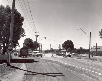
Photograph - Black and white
... This photograph depicts the road diversion on Nepean Highway that was implemented to allow construction of the railway line underneath the Nepean Highway at Moorabbin. ...Black and white photograph of road diversion on Nepean Highway, Moorabbin to allow the construction of the railway line below the Nepean Highway at Moorabbin and also to trench the station. ...City of Kingston Parkdale Library 96 Parkers Road, Parkdale Parkdale This photograph depicts the road diversion on Nepean Highway that was implemented to allow construction of the railway line underneath the Nepean Highway at Moorabbin. ...This photograph depicts the road diversion on Nepean Highway that was implemented to allow construction of the railway line underneath the Nepean Highway at Moorabbin. An "Allourie" Cheese, Honey Canned Ham van is prominent on the left of the image, the railway gates are central and the old Moorabbin Station is visble. Beyond the dates, pedestrians are visible crossing the Nepean Highway. This image is part of a larger collection of images from the Public Transport Corporation displaying train stations and streetscapes in what is now the City of Kingston.In 1958 excavations began for the removal of the level crossing gates at the southern end of the Moorabbin shopping centre on Nepean Highway. The station was also lowered below ground. A diversion route was created to enable the flow of traffic in both directions along the highway.Black and white photograph of road diversion on Nepean Highway, Moorabbin to allow the construction of the railway line below the Nepean Highway at Moorabbin and also to trench the station. This image is part of a larger collection of images from the Public Transport Corporation displaying train stations and streetscapes in what is now the City of Kingston.White adhesive dot sticker: Printed black 199 Handwritten in red ink: 80% Handwritten in black ink on yellow Post-It Note: [indecipherable] 199 - Diversion for Crossing Stamped in blue ink: COPYRIGHT Public Transport Corporation, For reordering photographs, Please quote negative No m 5687, Enquiries C/- PTC Photographic Unit, Telephone switchboard 619 1111railway crossing, railway station, city of moorabbin -
 Chelsea & District Historical Society Inc
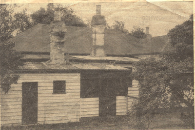
Photograph - Captain Lonsdale's Cottage, At Carrum
... Alexander and put up as a beach house in Point Nepean Road (Nepean Highway). In 1959, the cottage was removed from Carrum and was recovered by the National Trust....Newspaper cutting, picture of Captain Lonsdale's Cottage, when it was situated in Point Nepean Road, Carrum...Cottage Beach house Nepean Highway Point Nepean Road Captain Lonsdale Carrum Newspaper cutting, picture of Captain Lonsdale's Cottage, when it was situated in Point Nepean Road, Carrum At Carrum Photograph Captain Lonsdale's Cottage ...The cottage was built for Captain William Lonsdale (1799-1864), the first Police Magistrate of Melbourne. The cottage was built by the Royal Engineers in Sydney and flat packed to Melbourne in 1837, erected at Jolimont. In 1891 the cottage had to be removed to make way for the Jolimont Railway. It was bought by A. M. Alexander and put up as a beach house in Point Nepean Road (Nepean Highway). In 1959, the cottage was removed from Carrum and was recovered by the National Trust.Newspaper cutting, picture of Captain Lonsdale's Cottage, when it was situated in Point Nepean Road, Carrumcottage, beach house, nepean highway, point nepean road, captain lonsdale, carrum