Showing 153 items matching "new chum line"
-
 Bendigo Regional Archives Centre
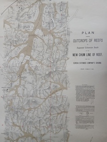
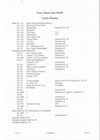
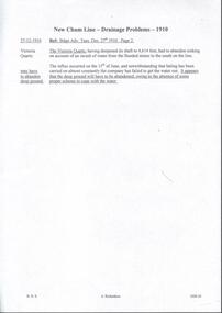
Map (item) - Plan of Outcrops of Reefs, New Chum Line of Reef, Norman Taylor, Geological Surveyor, Mines Department, Melbourne 1886 (in 2 parts, north and south), 1886
... Plan of Outcrops of Reefs, New Chum Line of Reef, Norman Taylor, Geological Surveyor, Mines Department, Melbourne 1886 (in 2 parts, north and south)...Plan of Outcrops of Reefs, New Chum Line of Reef, Norman Taylor, Geological Surveyor, Mines Department, Melbourne 1886 (in 2 parts, north and south)...Printed map Plan of Outcrops of Reefs, New Chum Line of Reef, Norman Taylor, Geological Surveyor, Mines Department, Melbourne 1886 (in 2 parts, north and south) Map Plan of Outcrops of Reefs, New Chum Line of Reef, Norman Taylor, Geological Surveyor, Mines Department, Melbourne 1886 (in 2 parts, north and south) Mines Department, Victoria ... -
 Bendigo Historical Society Inc.
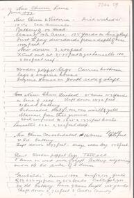
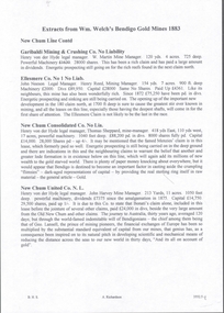
Document - NEW CHUM LINE OF REEF - SKETCH OF MINES ALONG THE NEW CHUM LINE OF REEF
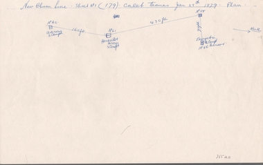
... NEW CHUM LINE OF REEF - SKETCH OF MINES ALONG THE NEW CHUM LINE OF REEF......New Chum Line Of Reef...Sketch of mines along part of the New Chum Line Of Reef. Sheet No 1 (179). Caleb Thomas Jan 28th 1879. ...History House 11 Mackenzie Street Bendigo goldfields DOCUMENT Gold New Chum Line Of Reef Sketch of Mines along the New Chum Line Of Reef Hercules Energetic Caleb Thomas Sketch of mines along part of the New Chum Line Of Reef. ...Sketch of mines along part of the New Chum Line Of Reef. Sheet No 1 (179). Caleb Thomas Jan 28th 1879. Plan. Hercules and Energetic Mines on drawing, 430 feet apart. Albert Richardson Collectiondocument, gold, new chum line of reef, sketch of mines along the new chum line of reef, hercules, energetic, caleb thomas -
 Bendigo Historical Society Inc.
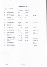
Document - NEW CHUM LINE OF REEF - PART OF A PLAN OF MINES ALONG THE NEW CHUM LINE OF REEF
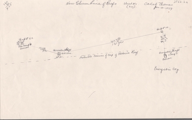
... NEW CHUM LINE OF REEF - PART OF A PLAN OF MINES ALONG THE NEW CHUM LINE OF REEF......New Chum Line Of Reef...Sketch of mines along the New Chum Line of Reef Sheet No 1 (811) Caleb Thomas Jun 28, 1879. ...History House 11 Mackenzie Street Bendigo goldfields DOCUMENT Gold New Chum Line Of Reef Part of a plan of mines along the New Chum Line Of Reef Caleb Thomas Hercules Mine Energetic Mine Energetic Coy Sketch of mines along the New Chum Line of Reef Sheet No 1 (811) Caleb Thomas Jun 28, 1879. ...Sketch of mines along the New Chum Line of Reef Sheet No 1 (811) Caleb Thomas Jun 28, 1879. Mines mentioned are the Hercules and the Energetic. The others are shaft numbers. Measurements between each in feet and yards. Probable course of cap of Victoria Reef drawn in.document, gold, new chum line of reef, part of a plan of mines along the new chum line of reef, caleb thomas, hercules mine, energetic mine, energetic coy -
 Bendigo Historical Society Inc.
Document - NEW CHUM LINE OF REEF - PLAN OF MINES ALONG PART OF THE NEW CHUM LINE OF REEF
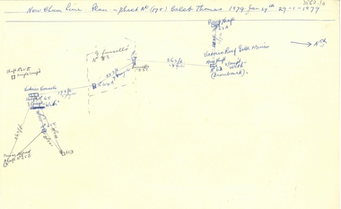
... NEW CHUM LINE OF REEF - PLAN OF MINES ALONG PART OF THE NEW CHUM LINE OF REEF......New Chum Line Of Reef...Sketch of some mines along the New Chum Line of Reef. Sheet No (178) Caleb Thomas 1879 Jan 29th. ...History House 11 Mackenzie Street Bendigo goldfields DOCUMENT Gold New Chum Line Of Reef Plan of Mines along part of the New Chum Line Of Reef Caleb Thomas Prince Alfred Mine Victoria Consols G Lansell's No 83 Ironbark Victoria Reef Gold Mines Sketch of some mines along the New Chum Line of Reef. ...Sketch of some mines along the New Chum Line of Reef. Sheet No (178) Caleb Thomas 1879 Jan 29th. Mines mentioned are: Prince Alfred, Victoria Consols, G Lansell's No 83. Some mines are only a number. Victoria Reef Gold Mines are mentioned. Distances in feet or yards between them.document, gold, new chum line of reef, plan of mines along part of the new chum line of reef, caleb thomas, prince alfred mine, victoria consols, g lansell's no 83, ironbark, victoria reef gold mines -
 Bendigo Historical Society Inc.
Map - NEW CHUM LINE, 1875
... NEW CHUM LINE......new chum line...Plan: Longtitudinal Section of the Northern Section of the New Chum Line of Reef. Compilation consisting of smaller sections stapled together...History House 11 Mackenzie Street Bendigo goldfields MAP new chum line Gold mines New Chum line of Reef Plan: Longtitudinal Section of the Northern Section of the New Chum Line of Reef. ...Plan: Longtitudinal Section of the Northern Section of the New Chum Line of Reef. Compilation consisting of smaller sections stapled togethermap, new chum line, gold mines, new chum line of reef -
 Bendigo Historical Society Inc.
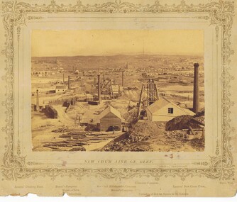
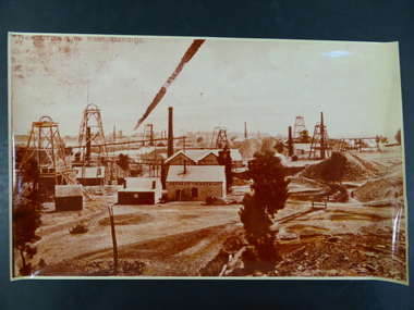
Photograph - VIEWS OF BENDIGO: NEW CHUM LINE OF REEF, 1875
... VIEWS OF BENDIGO: NEW CHUM LINE OF REEF......New Chum line of reef...Inscriptions: (on card) 'Views of Bendigo, No 2, New Chum Line of Reef....Inscriptions: (on card) 'Views of Bendigo, No 2, New Chum Line of Reef. Photograph VIEWS OF BENDIGO: NEW CHUM LINE OF REEF ...Sepia photograph of views of Sandhurst. Inscriptions: (on card) 'Views of Bendigo, No 2, New Chum Line of Reef.N J Caire, Sandhurstn j claire, views of bendigo, new chum line of reef -
 Bendigo Historical Society Inc.
Photograph - Photograph of New Chum Line of Reef
... Photograph of New Chum Line of Reef......New Chum Line of Reef...Sepia coloured print of a photograph of the New Chum Line of Reef looking south from the Snobs Hill group of mines. ...Photograph Photograph of New Chum Line of Reef ...BHS CollectionSepia coloured print of a photograph of the New Chum Line of Reef looking south from the Snobs Hill group of mines. The photo shows several poppet heads and chimneys, bridges and houses. New Chum Line of Reef. includes Victoria Hill possibly the richest spot on the field.On the back a drawing of a poppet head with the words: Bendigo gold project. A small map of Victoria is also printed on the back. bendigo mines, new chum line of reef, mining -
 Bendigo Historical Society Inc.
Map - NEW CHUM LINE, 1875
... NEW CHUM LINE...... New Chum Line...Plan: Longtitudinal section of the Southern Section of the New Chum Line of Reef. Compilation consisting of small sections stapled together...History House 11 Mackenzie Street Bendigo goldfields MAP mining plan Gold Mines New Chum Line CALEB THOMAS 1875 Plan: Longtitudinal section of the Southern Section of the New Chum Line of Reef. ...Plan: Longtitudinal section of the Southern Section of the New Chum Line of Reef. Compilation consisting of small sections stapled togetherCALEB THOMAS 1875map, mining plan, gold mines, new chum line -
 Bendigo Historical Society Inc.
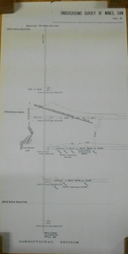
Document - NEW CHUM LINE OF REEF - REFERENCE FOR CALEB THOMAS PLANS
... NEW CHUM LINE OF REEF - REFERENCE FOR CALEB THOMAS PLANS......New Chum Line of Reef...The numbers refer to mines on the New Chum Line of Reef....The numbers refer to mines on the New Chum Line of Reef. Document NEW CHUM LINE OF REEF - REFERENCE FOR CALEB THOMAS PLANS ...Two handwritten pages of reference numbers for Caleb Thomas plans. The numbers refer to mines on the New Chum Line of Reef.document, gold, new chum line of reef, reference for caleb thomas plans, new chum bellevue & railway reserve, bellevue & new chum, shenandoah, shamrock, old chum, little chum, new chum trib, young chum, cravens, garibaldi, no 1 ellesmere coy, new chum consolidated, ellesmere, new chum united, lansell's 222 (denis), lansell's 222 (new shaft), koch & hildebrandt (lansell's 222), lazarus co, sheer legs, old chum, new chum & victoria, north old chum, lansell's 180, victoria quartz, gt cent vic, victoria consols, victoria reef co (ironbark), hercules, energetic ladder shaft, energetic shaft -
 Bendigo Historical Society Inc.
Map - PLAN NEW CHUM LINE OF REEF
... PLAN NEW CHUM LINE OF REEF......new chum line of reef...Plan showing outcrops of reefs on supposed extension south of the New Chum line of reef from the Eureka extended company's ground. ...History House 11 Mackenzie Street Bendigo goldfields PLAN Bendigo new chum line of reef Plan showing outcrops of reefs on supposed extension south of the New Chum line of reef from the Eureka extended company's ground. ...Plan showing outcrops of reefs on supposed extension south of the New Chum line of reef from the Eureka extended company's ground. Scale 8 chains to 1 inchplan, bendigo, new chum line of reef -
 Bendigo Historical Society Inc.
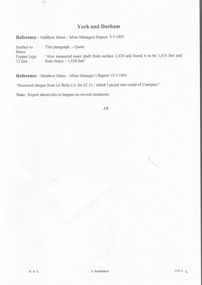
Document - MARKS COLLECTION: NEW CHUM LINE OF REEF MAP
... MARKS COLLECTION: NEW CHUM LINE OF REEF MAP......new chum line of reef...Plan (copy) of New Chum Line of Reef. Plan has been copied in two sections. ...History House 11 Mackenzie Street Bendigo goldfields BENDIGO Mining new chum line of reef Plan (copy) of New Chum Line of Reef. ...Plan (copy) of New Chum Line of Reef. Plan has been copied in two sections. On top of plan 'Underground survey of mines Sandhurst, New Chum Line of Reef', plan shows longitudinal and cross section views of the workings on the reef. Shaft No. 76 marked. Datum line on top indicates 750' above sea level, on bottom of plan, bottom of shaft 2022.24 below sill. Drawn by Arthur Everett, Mining Department, Melbourne, 1884.bendigo, mining, new chum line of reef -
 Bendigo Historical Society Inc.
Document - ALBERT RICHARDSON COLLECTION: NEW CHUM LINE OF REEF MINES
... ALBERT RICHARDSON COLLECTION: NEW CHUM LINE OF REEF MINES......new chum line of reef...Five page document, handwritten, detailing the mines along the New Chum Line of Reef. A table of information is attached with data about the early workings on the reef line. ...History House 11 Mackenzie Street Bendigo goldfields BENDIGO Mining new chum line of reef Five page document, handwritten, detailing the mines along the New Chum Line of Reef. ...Five page document, handwritten, detailing the mines along the New Chum Line of Reef. A table of information is attached with data about the early workings on the reef line. Calls, dividends, ounces of gold extracted and depth of shafts are described.bendigo, mining, new chum line of reef -
 Bendigo Historical Society Inc.
Document - NEW CHUM LINE OF REEF - GOLD PRODUCTION ON THE NEW CHUM LINE OF REEF
... NEW CHUM LINE OF REEF - GOLD PRODUCTION ON THE NEW CHUM LINE OF REEF......New Chum Line of Reef... OF REEF - GOLD PRODUCTION ON THE NEW CHUM LINE OF REEF ...Handwritten page containing the names of mines and the number of ounces of gold they produced. Mines mentioned are: Lansell's 222, Lazarus New Chum, Old Chum, New Chum & Victoria, North Old Chum, Lansell's Big 180, Victoria Quartz, Gt Central Victoria, Victoria Consols, South Adventure Group, Adventure, Advance, Try - Me - Well, Prince Alfred, Alfred Co, Lansell's 83 and Ironbark (no production figures). Note beside Alfred & Co - Land pegged by J R Evans in 1857.document, gold, new chum line of reef, gold production on the new chum line of reef, lansell's 222, lazarus new chum, old chum, new chum & victoria, north old chum, lansell's big 180, victoria quartz, gt central victoria, victoria consols, south adventure group, adventure, advance, try - me - well, prince alfred, alfred co, lansell's 83, ironbark, j r evans -
 Bendigo Historical Society Inc.
Document - NEW CHUM LINE OF REEF - NOTES ON SHAFT DETAILS ON THE NEW CHUM LINE OF REEF
... NEW CHUM LINE OF REEF - NOTES ON SHAFT DETAILS ON THE NEW CHUM LINE OF REEF......New Chum Line of Reef...Ten pages and one smaller page of notes showing depth of shaft, sill, size of shaft, relation to line of reef, depth bottom plat, depth to bottom of well, number of compartments, reference and remarks. Mines mentioned are: Young Chum, Old Chum (Old South), Shamrock, Shenandoah, New Chum Railway, Eureka Ext'd, South Belle Vue United, Lansell's 222, Denis Shaft, New Chum United, Ellesmere (North Shaft), New Chum Consolidated, Ellesmere No 1 or (South Shaft) also known as New Chum Coy, Garibaldi, Craven's, Lansell's Bit 180, North Old Chum, New Chum & Victoria, Old Chum, Lazarus New Chum Main, Lazarus New Chum (Old), Victoria Reef Gold (Ironbark), Victoria Consols, Adventure & Advance, Gt Central Victoria, Ballerstedt, Humbold, Victoria (Reef) Quartz, Pearl (later Hercules New Chum), Hercules Extended (Pearl (South) later, North Hercules, Hercules and Energetic, Hercules (Old),South Devonshire, Duchess Tribute, New St Mungo, Duke of Edinburgh, New Victoria Catherine (later Hercules Consols), Dixon's Tribute, Great Victoria Extended, Hopewell, Saxon & Celt Extended, St Mungo, Princess Alexander, West United Devonshire, United Devonshire, Duchess of Edinburgh, Sadowa, (Old) St Mungo, Lady Barkly, Princess Alice (South St Mungo) previously Gov. ...Note initialed AR. Document NEW CHUM LINE OF REEF - NOTES ON SHAFT DETAILS ON THE NEW CHUM LINE OF REEF ...Ten pages and one smaller page of notes showing depth of shaft, sill, size of shaft, relation to line of reef, depth bottom plat, depth to bottom of well, number of compartments, reference and remarks. Mines mentioned are: Young Chum, Old Chum (Old South), Shamrock, Shenandoah, New Chum Railway, Eureka Ext'd, South Belle Vue United, Lansell's 222, Denis Shaft, New Chum United, Ellesmere (North Shaft), New Chum Consolidated, Ellesmere No 1 or (South Shaft) also known as New Chum Coy, Garibaldi, Craven's, Lansell's Bit 180, North Old Chum, New Chum & Victoria, Old Chum, Lazarus New Chum Main, Lazarus New Chum (Old), Victoria Reef Gold (Ironbark), Victoria Consols, Adventure & Advance, Gt Central Victoria, Ballerstedt, Humbold, Victoria (Reef) Quartz, Pearl (later Hercules New Chum), Hercules Extended (Pearl (South) later, North Hercules, Hercules and Energetic, Hercules (Old),South Devonshire, Duchess Tribute, New St Mungo, Duke of Edinburgh, New Victoria Catherine (later Hercules Consols), Dixon's Tribute, Great Victoria Extended, Hopewell, Saxon & Celt Extended, St Mungo, Princess Alexander, West United Devonshire, United Devonshire, Duchess of Edinburgh, Sadowa, (Old) St Mungo, Lady Barkly, Princess Alice (South St Mungo) previously Gov. Barkly, Unicorn (Trib), Phoenix, Williams (New), Acadia Catherine, William United (Old Shaft), Snob's Hill Shaft, York & Durham, Belmont & Saxby, Ellenborough, Catherine Reef Extended, New Franklin, Murchison, Catherine Reef United Main Shaft, Catherine Reef United South Shaft. Small page has notes on the York and Durham: Reference - Matthew Mann - Mine Manager's Report 3/7/1893. This paragraph: Quote - 'Also measured main shaft from surface 1,430 and found it to be 1,416 feet and from Brace - 1,428 feet. Poppet legs 12 feet. Reference - Matthew Mann - Mine Manager's Report 15/7/1893 'Received cheque from La Belle Co. for 2 pound 13 shillings - which I paid into credit of Company'. Note: Report shows this to happen on several occasions. Note initialed AR.document, gold, new chum line of reef, notes on shaft details on the new chum line of reef, young chum, old chum (old south), shamrock, shenandoah, new chum railway, eureka ext'd, south belle vue united, lansell's 222, denis shaft, new chum united, ellesmere (north shaft), new chum consolidated, ellesmere no 1 or (south shaft) also known as new chum coy, garibaldi, craven's, lansell's bit 180, north old chum, new chum & victoria, old chum, lazarus new chum main, lazarus new chum (old), victoria reef gold (ironbark), victoria consols, adventure & advance, gt central victoria, ballerstedt, humbold, victoria (reef) quartz, pearl (later hercules new chum), hercules extended (pearl (south) later, north hercules, hercules and energetic, hercules (old), south devonshire, duchess tribute, new st mungo, duke of edinburgh, new victoria catherine (later hercules consols), dixon's tribute, great victoria extended, hopewell, saxon & celt extended, st mungo, princess alexander, west united devonshire, united devonshire, duchess of edinburgh, sadowa, (old) st mungo, lady barkly, princess alice (south st mungo) previously gov. barkly, unicorn (trib), phoenix, williams (new), acadia catherine, william united (old shaft), snob's hill shaft, york & durham, belmont & saxby, ellenborough, catherine reef extended, new franklin, murchison, catherine reef united main shaft, catherine reef united south shaft -
 Bendigo Historical Society Inc.
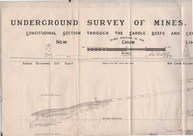
Map - STRUGNELL COLLECTION: NEW CHUM LINE OF REEF, 5/4/01
... STRUGNELL COLLECTION: NEW CHUM LINE OF REEF......new chum line...Map, Along portion of the New Chum Line, Underground Survey of Mines, Bendigo, Longitudinal Section through the Saddle Reefs and Centre Country. ...History House 11 Mackenzie Street Bendigo goldfields MAP Bendigo new chum line H.S.Whitelow Map, Along portion of the New Chum Line, Underground Survey of Mines, Bendigo, Longitudinal Section through the Saddle Reefs and Centre Country. ...Map, Along portion of the New Chum Line, Underground Survey of Mines, Bendigo, Longitudinal Section through the Saddle Reefs and Centre Country. Eureka Extended Co's shaft, New Chum Railway Co's shaft. Surveyed under the supervision of H.Herman, B.C.E., F.G.S., Acting Government Geologist.H.S.Whitelowmap, bendigo, new chum line -
 Bendigo Historical Society Inc.
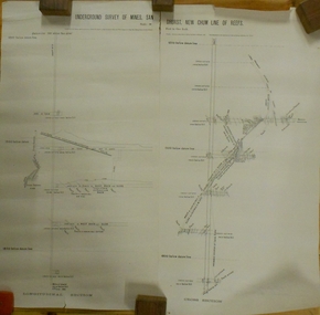
Plan - MARKS COLLECTION: UNDERGROUND SURVEY OF MINES SANDHURST NEW CHUM LINE OF REEF
... MARKS COLLECTION: UNDERGROUND SURVEY OF MINES SANDHURST NEW CHUM LINE OF REEF......new chum line of reef...Plan, divided into two sheets, on top of sheet Underground survey of mines Sandhurst, New Chum Line of Reef. Surveyed by Caleb Thomas under the direction of Charles W. ...History House 11 Mackenzie Street Bendigo goldfields BENDIGO Mining new chum line of reef Plan, divided into two sheets, on top of sheet Underground survey of mines Sandhurst, New Chum Line of Reef. ...Plan, divided into two sheets, on top of sheet Underground survey of mines Sandhurst, New Chum Line of Reef. Surveyed by Caleb Thomas under the direction of Charles W. Langtree, Acting Secretary for Mines and Water Supply and Acting Chief Mining Surveyor for the Colony of Victoria. Drawn by Arthur Everett, Mining Department, Melbourne, 1884.bendigo, mining, new chum line of reef -
 Bendigo Historical Society Inc.
Document - VICTORIA HILL - VICTORIA HILL, NEW CHUM LINE LEASES
... VICTORIA HILL - VICTORIA HILL, NEW CHUM LINE LEASES... Victoria Hill New Chum Line Leases...Drawing of leases with lease numbers, names of owners and names of mines on the New Chum Line of Reef. Lease numbers are: L296, L1505, L5394, L7486, 130, L1286, L3941, L6299, L7427, L323, L3175, L812, L3757, L3888, L6198, L703, L1130, L703, L3321, L3347, L3884, L4167, L4357, L6296, L55, L239, L962, L1494, L1708, L239, L962, L3320, L4779, L6457, L129, L961, L3926, L5566, L19, L959, L4652, L4895, L5371, L7740, L960, L4415, L4793....Document VICTORIA HILL - VICTORIA HILL, NEW CHUM LINE LEASES ...Drawing of leases with lease numbers, names of owners and names of mines on the New Chum Line of Reef. Lease numbers are: L296, L1505, L5394, L7486, 130, L1286, L3941, L6299, L7427, L323, L3175, L812, L3757, L3888, L6198, L703, L1130, L703, L3321, L3347, L3884, L4167, L4357, L6296, L55, L239, L962, L1494, L1708, L239, L962, L3320, L4779, L6457, L129, L961, L3926, L5566, L19, L959, L4652, L4895, L5371, L7740, L960, L4415, L4793.document, gold, victoria hill, victoria hill, victoria hill new chum line leases, j wybrants, s h mcgowan, north old chum n l, c & t ballerstedt, ballerstedt & son, geo lansell, j holmes, victoria reef company, h hawkins, victoria reef quartz mining co n l, g n craig, j g wheadon, wells & gibbs, midway co, s g cole, gibbs ballerstedt & wells united mining co, w barker, humboldt g m co, great central victoria co n l, howard and neumann, endeavor qtz mining co, woodward & gibbs, endeavor co, smith horner white and tipping, albert co, h birch, victoria consols mining co, victoria reef, sullivan jackson, nicholas ballerstedt & jones, ironbark quartz mining co, j h abbott, ironbark co n l, h y north, new chum consolidated g m co, d macdougall, h von der heyde, hercules & energetic co n l -
 Bendigo Historical Society Inc.
Document - ALBERT RICHARDSON COLLECTION: NEW CHUM LINE OF REEF MINES 1861, 1970's
... ALBERT RICHARDSON COLLECTION: NEW CHUM LINE OF REEF MINES 1861......New Chum reef line...Fourteen page photocopy of information, written by Albert Richardson, regarding goldmines along the New Chum line of reef. Information includes owners of the mine; workings; reef and yield; cost and labor; drainage and machinery used, horses etc. ... Garibaldi Company's Claim New Chum McDougall New Chum Quartz Mining Company Bonati and Company Denis's Claim Begelhole Company Watson and Company Gibbs and Lazarus Company Phoenix Company's Claim Burrows and Company Fourteen page photocopy of information, written by Albert Richardson, regarding goldmines along the New Chum line of reef. ...Albert Richardson was a past President of the Bendigo Historical Society. He had a great interest in the history of the Bendigo goldfield. A reserve in Marong Road, adjoining Victoria Hill mine precint, is named in honour of Albert and his contribution to recording the mining history of Bendigo. In this document, Albert has listed some early mines on the New Chum reefline. The Garibaldi Gold Mining Company, near the corner of Rose and Mackenzie Streets, Bendigo, was listed in the Victorian Government Gazettes on October 26th, 1860. Gazette 136 Page 2035. All the shareholders gave their place of residence as either Swanston or Collins Street, Melbourne. Bonati's Gold Mining Company was gazetted on 13th January, 1871 Gazette 2 Page 55. Carl Mueller was the Manager of the Company, which was situated on the 'New Chum Reef, Bendigo'. Fourteen page photocopy of information, written by Albert Richardson, regarding goldmines along the New Chum line of reef. Information includes owners of the mine; workings; reef and yield; cost and labor; drainage and machinery used, horses etc. Mines listed are: Garibaldi Company's Claim New Chum McDougall New Chum Quartz Mining Company Bonati and Company Denis's Claim Begelhole Company Watson and Company Gibbs and Lazarus Company Phoenix Company's Claim Burrows and Company gold mine, new chum reef line, garibaldi company's claim, new chum, mcdougall, new chum quartz mining company, bonati and company, denis's claim, begelhole company, watson and company, gibbs and lazarus company, phoenix company's claim, burrows and company -
 Bendigo Historical Society Inc.
Photograph - NEW CHUM LINE OF REEF, FROM OLD CHUM HILL
... NEW CHUM LINE OF REEF, FROM OLD CHUM HILL......new chum line of reef...History House 11 Mackenzie Street Bendigo goldfields PLACE Landscape view new chum line of reef Black and white photo (copy?) ...Black and white photo (copy?) of view of Old Chum Line of Reef from Old Chum Hill. Lansell's '222 Mine' tallest poppet legs on the Bendigo Field. Golden Square in the distance. Corner of 'grounds at right (Geo. Lansell's mansion)place, landscape view, new chum line of reef -
 Bendigo Historical Society Inc.
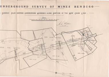
Map - STRUGNELL COLLECTION: NEW CHUM LINE, 25/5/01
... STRUGNELL COLLECTION: NEW CHUM LINE......new chum line...Map STRUGNELL COLLECTION: NEW CHUM LINE ...Map, Surface Plan Showing underground workings along portion of the New Chum Line.South Belle Vue United, Eureka Extended, New Chum Railway, Shenandoah Co. Shamrock Co..A.S.Whitelawmap, bendigo, new chum line -
 Bendigo Historical Society Inc.
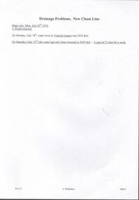
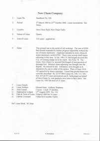
Document - DRAINAGE PROBLEMS - DRAINAGE PROBLEMS NEW CHUM LINE
... DRAINAGE PROBLEMS - DRAINAGE PROBLEMS NEW CHUM LINE...New Chum Drainage Association... Drainage Problems New Chum Line...Document DRAINAGE PROBLEMS - DRAINAGE PROBLEMS NEW CHUM LINE ...Handwritten copy of a report from the Bendigo Advertiser 25/7/1910. 'A Weeks Record. On Monday, July 18th, water level at Victoria Quartz was 3034 feet. On Saturday (July 23rd) the water had only been lowered to 3059 feet. A gain of 25 feet for a week. Document from Albert Richardson Collection of mining history.gold, drainage problems, new chum drainage association, drainage problems new chum line, victoria quartz, bendigo advertiser 25/7/1910 & 23/7/1910, albert richardson -
 Bendigo Historical Society Inc.
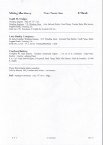
Document - NEW CHUM & VICTORIA LINES OF REEF - MINING MACHINERY, NEW CHUM LINE, EAGLEHAWK
... NEW CHUM & VICTORIA LINES OF REEF - MINING MACHINERY, NEW CHUM LINE, EAGLEHAWK...New Chum & Victoria Lines of Reef... Mining Machinery New Chum Line...Document NEW CHUM & VICTORIA LINES OF REEF - MINING MACHINERY, NEW CHUM LINE, EAGLEHAWK ...Handwritten notes on mining machinery sold at auction. South St Mungo - Winding Engine. Pair of 15 ? Cyl. Winding Engines. 7 ft Winding Gear. Also, Jackass Boiler. Feed Pump, Trucks, Rails, Flat Sheets, Poppet Heads, Housing, etc. Sold for 270 pounds. Purchaser H Ralph for Austral Drill Co. Lady Barkly Company - 12-inch Cylinder Winding Engine. 8 ft Winding Gear. Cornish Flue Boiler, Feed Pump, Rails, Poppet Heads, Housing, etc. Sold for 162 pound 10 shillings. Purchaser W. J. Sever, Mining Merchants, Melb. Crushing Battery - Complete 40 Head Battery. Tandem Compound Engine. 11 in & 22 in Cylinders. High Press, Boilers, Electric Lighting Plant. 6 in Cyl. High Speed Engine, Fire-proof, Feed Pump, Rails, Flat Sheets, Tools & Sundries. 1000 pound to R. Ralph. These three mining plants, complete. Sold by Messrs. Bell, Lambert and Nixon - Auctioneers. Ref; Bendigo Advertiser. July 14th, 1910, Page 2.document, gold, new chum & victoria lines of reef, mining machinery new chum line eaglehawk, south st mungo, h ralph, austral drill co, lady barkly company, w j sever, crushing battery, messrs bell, lambert and nixon -
 Bendigo Historical Society Inc.
Document - DRAINAGE PROBLEMS - NEW CHUM LINE DRAINAGE PROBLEMS 1910
... DRAINAGE PROBLEMS - NEW CHUM LINE DRAINAGE PROBLEMS 1910...... New Chum Line Drainage Problems 1910...Document DRAINAGE PROBLEMS - NEW CHUM LINE DRAINAGE PROBLEMS 1910 ...Handwritten extract from the Bendigo Advertiser 27/12/1910 Page 2. ''The Victoria Quartz, having deepened its shaft to 4,614 feet, had to abandon sinking on account of an inrush of water from the flooded mines to the south on the line. The influx occurred on the 15th of June, and notwithstanding that baling has been carried on almost constantly the company has failed to get the water out. It appears that the deep ground will have to be abandoned, owing to the absence of some proper scheme to cope with the water.'' Albert Richardson Mining History Collection.document, gold, drainage problems, drainage problems, new chum line drainage problems 1910, bendigo advertiser 27/12/1910 page 2, victoria quartz, albert richardson -
 Bendigo Historical Society Inc.
Document - NEW CHUM LINE OF REEF - EXTRACTS FROM WM WELCH'S BOOKS
... NEW CHUM LINE OF REEF - EXTRACTS FROM WM WELCH'S BOOKS......New Chum Line of Reef...New Chum Consolidated Co N L and Thomas Sheppard, Mine Manager. Henry von der Hyde, Legal Manager of New Chum United N L and John Harvey, Mine Manager. Lazarus New Chum Co Reg'd and Lazarus New Chum No 1 Co Reg'd, Henry von der Hyde, Legal Manager and George Armstrong, Mine Manger to both companies. Document NEW CHUM LINE ...Three pages of notes on Garibaldi, Ellesmere Co No 1, New Chum Consolidated Co N. L. New Chum United Co, Lazarus New Chum Co Reg'd and Lazarus New Chum No 1. Notes include Legal Manager, Mining Manager, size of lease, machinery, information on shares and dividends. Henry von der Hyde was the Legal Manager of the Garibaldi and W Martin, the Mine Manager. John Neeson, the Legal Manager of the Ellesmere Co No 1 and Henry Reed, Mine Manager. Henry Von der Hyde, Legal Manager of New Chum Consolidated Co N L and Thomas Sheppard, Mine Manager. Henry von der Hyde, Legal Manager of New Chum United N L and John Harvey, Mine Manager. Lazarus New Chum Co Reg'd and Lazarus New Chum No 1 Co Reg'd, Henry von der Hyde, Legal Manager and George Armstrong, Mine Manger to both companies.document, gold, new chum line of reef, extracts from wm welch's books, garibaldi mining & crushing co n l, henry von der hyde, w martin, ellesmere co no 1 n l, john neeson, henry reed, new chum consolidated co n l, thomas sheppard, menzies claim, new chum united co n l, john harvey, bonate's claim, old new chum, geo lansell, lazarus new chum co reg'd, lazarus new chum no 1 co reg'd, george armstrong, gibbs, lazarus, wm welch's bendigo gold mines 1883, wm welch's bendigo mining registry, wm welch's guide to the bendigo gold mines -
 Bendigo Historical Society Inc.
Document - NEW CHUM LINE OF REEF - REFERENCE TO CALEB THOMAS PLANS
... NEW CHUM LINE OF REEF - REFERENCE TO CALEB THOMAS PLANS......New Chum Line Of Reef...History House 11 Mackenzie Street Bendigo goldfields DOCUMENT Gold mines New Chum Line Of Reef Reference to Caleb Thomas Plans Catherine Reef Extd. ...Five pages (typed copy of Albert Richardson original) of reference numbers used on Caleb Thomas plans. The mine's name, size of shaft and on other pages, the height of the sill. document, gold, mines, new chum line of reef, reference to caleb thomas plans, catherine reef extd., new franklin, murchison, catherine reef united, catherine reef (south), acadia catherine, william's united, york & durham, belmont & saxby, ellenborough, sadowa, (old) st mungo, lady barkly, princess alice (sth st mungo), unicorn trib, pheonix, hopewell, united devonshire (princess alex), west united devonshire, east united devonshire, duchess of edinburgh, south devonshire, duchess tribute, new st mungo, new st mungo, new vict catherine, gt extd vict, herc new chum (late pearl), pearl south, north herc & energetic, herc & energetic, ironbark, vict consols, south new chum, lansell's 616, south belle vue, eureka extd, new chum rly, south old chum, new chum consolidated, ellesmere (south shaft), garibaldi, cravens, young chum, ellesmere nth shaft, new chum united, new chum vic, old chum, lazarus, cent new chum, lansell's 222, north old chum, lansell's big 180, advents advance, gt cent vict, hamboldt, ballerstedt, victoria quartz, herc & energetic, herc (old), shenandoah, victoria reef gold, victoria consols -
 Bendigo Historical Society Inc.
Document - NEW CHUM LINE OF REEF - LEASE SANDHURST NO 100 NEW CHUM COMPANY
... NEW CHUM LINE OF REEF - LEASE SANDHURST NO 100 NEW CHUM COMPANY......New Chum Line of Reef...History House 11 Mackenzie Street Bendigo goldfields DOCUMENT Gold New Chum Line of Reef Lease Sandhurst No 100 New Chum Company D McDougall Menzies Claim R Schlesinger Edward Hunt Anthony Stephens Lease Book Mines Dept Handwritten page of notes on the New Chum Company, Lease Sandhurst No 100. ...Handwritten page of notes on the New Chum Company, Lease Sandhurst No 100. Notes give period of lease, locality, nature of lease and area of lease. In 1863 there was a disagreement with neighboring leases. By 22/10/1866 Leases 81, 100.113.306,424,425 & 872 were surrendered and R Schlesinger on behalf of New Chum Co was granted a new lease in their place. Item 7 Lease details, Edward Hunt & Anthony Stephens, Lease holders Application lodged 13/8/1859 No 134. Date 5/3/1860 for a term of ten years. Reference; Lease Book, Mines Department.document, gold, new chum line of reef, lease sandhurst no 100 new chum company, d mcdougall, menzies claim, r schlesinger, edward hunt, anthony stephens, lease book mines dept -
 Bendigo Historical Society Inc.
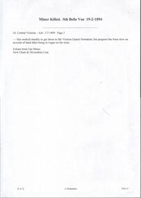
Document - VICTORIA QUARTZ - EXTRACT FROM OUR 'MINES' NEW CHUM & DEVONSHIRE LINE
... VICTORIA QUARTZ - EXTRACT FROM OUR 'MINES' NEW CHUM & DEVONSHIRE LINE... Extract from Our 'Mines' New Chum & Devonshire Line...Handwritten extract from Our Mines New Chum & Devonshire Line. Written on the paper is: Miner Killed Sth Belle Vue 19/2/1894. ...History House 11 Mackenzie Street Bendigo goldfields DOCUMENT Gold victoria quartz Victoria Quartz Extract from Our 'Mines' New Chum & Devonshire Line Sth Belle Vue Great Central Victoria Our 'Mines' New Chum & Devonshire Line Handwritten extract from Our Mines New Chum & Devonshire Line. ...Handwritten extract from Our Mines New Chum & Devonshire Line. Written on the paper is: Miner Killed Sth Belle Vue 19/2/1894. Great Central Victoria - Adv 3/7/1899 Page 3. Has worked steadily to get down to the Victoria Quartz formation; but progress has been slow on account of hand labour being in vogue on the mine. Extract from Our'Mines' New Chum & Devonshire Line.document, gold, victoria quartz, victoria quartz, extract from our 'mines' new chum & devonshire line, sth belle vue, great central victoria, our 'mines' new chum & devonshire line -
 Bendigo Historical Society Inc.
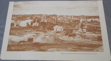
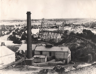
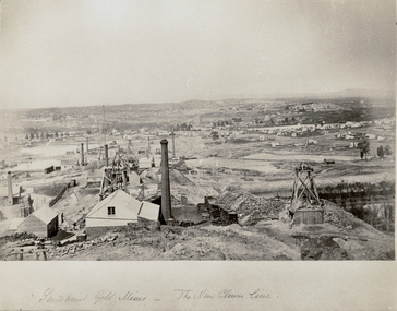
Photograph - THE NEW CHUM LINE OF REEF, c.1870
... THE NEW CHUM LINE OF REEF...Large view of the New Chum Line mining site. Mines in foreground. ...Photograph THE NEW CHUM LINE OF REEF ...Black and white photograph. Large view of the New Chum Line mining site. Mines in foreground. Homes in background. Looking South towards Golden Square. Inscriptions: on front - handwritten - 'Sandhurst Gold Mines - The New Chum Line'. C1873, earlier than NH Caire (1875) - James Lerk 12.11.1999.place, mining site, new chum -
 Bendigo Historical Society Inc.
Photograph - NEW CHUM LINE REEF
... NEW CHUM LINE REEF...Sepia photograph showing New Chum Line Reef Bendigo with shed in foreground signed Duchess Tribute surrounded by Poppet Heads....Photograph NEW CHUM LINE REEF ...Sepia photograph showing New Chum Line Reef Bendigo with shed in foreground signed Duchess Tribute surrounded by Poppet Heads.photograph, landscape, gold mine, bendigo-history-goldmines-new chum reef -
 Bendigo Historical Society Inc.
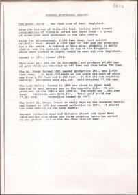
Document - NEW CHUM LINE OF REEF MUNGO GROUP EAGLEHAWK
... NEW CHUM LINE OF REEF MUNGO GROUP EAGLEHAWK...Two page document detailing the Mungo Group of Mines along the New Chum line of reef, Eaglehawk. The mines described are: Ellenborough, 2100 feet deep St Mungo, 2,600 feet deep The Lady Barkly, 1,350 feet deep, close to Upper Road with a 40 head battery on the other side. ...Document NEW CHUM LINE OF REEF MUNGO GROUP EAGLEHAWK ...Two page document detailing the Mungo Group of Mines along the New Chum line of reef, Eaglehawk. The mines described are: Ellenborough, 2100 feet deep St Mungo, 2,600 feet deep The Lady Barkly, 1,350 feet deep, close to Upper Road with a 40 head battery on the other side. South St Mungo, known as the Governor Barkly in the earlier days. Small map on second page shows the location of the Sadowa shaft, St. Mungo shaft and the Lady Barkly shaft. Victoria Street and Upper Road marked on the map. 'Between Caldwells Road and Victoria Street and Upper Road intersection, nine mines and three crushing batteries worked at one period. All on the New Chum line of reef.' Not signed but most probably written by Albert Richardson.bendigo, mining, mungo group of mines, eaglehawk