Showing 417 items matching "new north building"
-
 Federation University Historical Collection
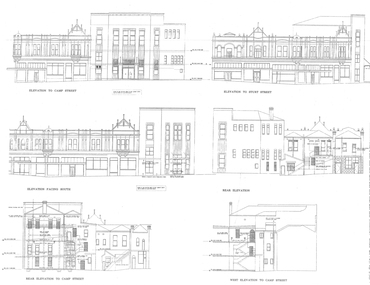
Plans, University of Ballarat Arts Academy Plans, c2000
... new north building...Barker Library (top floor) Mount Helen goldfields new north building new south building mining exchange ballarat post office former ballarat court house former ballarat library Copies of the plans for the University of Ballarat Arts Academy, Camp Street, Ballarat. ...Copies of the plans for the University of Ballarat Arts Academy, Camp Street, Ballarat.new north building, new south building, mining exchange, ballarat post office, former ballarat court house, former ballarat library -
 Lakes Entrance Historical Society
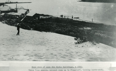
Photograph - New Works, 1895c
... Black and white photograph showing view from top of hummocks overlooking New Works buildings. North end of eastern pier on left, Cunninghame Arm in front of building. ...Lakes Entrance Historical Society 4 Marine Parade Lakes Entrance gippsland Photo taken from approx present ramp up to flagstaff, looking north-west Jetties Waterfront Historic Buildings Rear view of some New Works buildings 1895c Black and white photograph showing view from top of hummocks overlooking New Works buildings. ...Photo taken from approx present ramp up to flagstaff, looking north-westBlack and white photograph showing view from top of hummocks overlooking New Works buildings. North end of eastern pier on left, Cunninghame Arm in front of building. Lakes Entrance VictoriaRear view of some New Works buildings 1895cjetties, waterfront, historic buildings -
 Lakes Entrance Historical Society
Postcard - SS Wyrallah, SS Manawatu, c1910
... Sepia toned postcard showing view of New Works buildings at north end of eastern pier. Cunninghame Arm in front of buildings, Reeves River left in distance. ...Lakes Entrance Historical Society 4 Marine Parade Lakes Entrance gippsland Ships and Shipping Piers Historic Site Lakes Entrance - Gippsland Lakes Sepia toned postcard showing view of New Works buildings at north end of eastern pier. Cunninghame Arm in front of buildings, Reeves River left in distance. ...Sepia toned postcard showing view of New Works buildings at north end of eastern pier. Cunninghame Arm in front of buildings, Reeves River left in distance. SS Wyrallah steaming past, and SS Manawatu at pier. Jemmy's Point, Mt Barkly, and Kalimna hills in background. Photo taken from top of dune. Smoke issuing from SS Wyrallah funnel. Carstairs boarding house in centre foreground. Lakes Entrance VictoriaLakes Entrance - Gippsland Lakes ships and shipping, piers, historic site -
 Warrnambool and District Historical Society Inc.
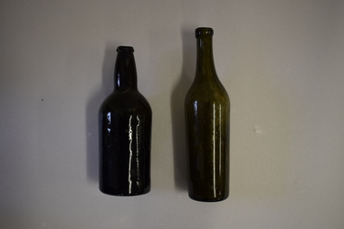
Bottles (2), Bottle, c. 1900
... These two bottles were found by workmen building a new retaining wall on the north side of the Les O’Callaghan History House building in Gilles Street Warrnambool. ...Warrnambool and District Historical Society Inc. 2 Gilles Street (south of Merri St) Warrnambool great-ocean-road These two bottles were found by workmen building a new retaining wall on the north side of the Les O’Callaghan History House building in Gilles Street Warrnambool. ...These two bottles were found by workmen building a new retaining wall on the north side of the Les O’Callaghan History House building in Gilles Street Warrnambool. The wall replaced one damaged beyond repair following a car accident in 2019. The building was erected in 1889 as the caretaker’s cottage in the Warrnambool Sea Baths complex (for most of its existence it had two swimming pools, a hot sea water baths building and a caretaker’s cottage). The water in the baths were pumped up from the ocean and, for the hot baths, heated on site. These baths were the municipal baths until the mid 1950s. The bottles may have originated from the one of the families residing in the cottage or from passers-by in the adjoining Merri Street or from patrons of the baths. They appear to be over 100 years old but there is no way the ownership of the bottles can be established.These bottles are of interest as archeological finds after repair works to the Les O’Callaghan History House. .1 A dark green (or black?) glass bottle with a hollowed out concave base, no stopper and a slightly chipped rim on the top. The bottle is stained inside. .2 A green glass bottle with a hollowed out concave base, a moulded top with no stopper and an elongated neck. The bottle is stained inside. warrnambool & district historical society, heritageworks warrnambool, les o’callaghan history house, warrnambool, history of warrnambool -
 Warrnambool and District Historical Society Inc.
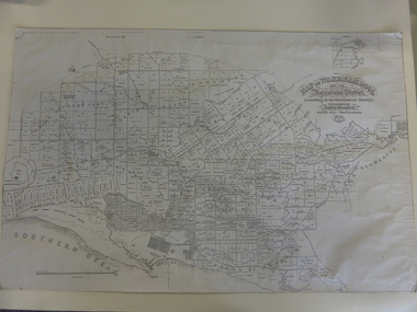
Map, Warrnambool 1859, Late 20th century (copy)
... new building erected in 1875. Bromfield was a prominent resident of Warrnambool (Shire Councillor, Fire Brigade member, Cricket Club member, associated with horse racing etc). He was interested in preserving the history of Warrnambool and this map he produced in 1856 was an example of this interest. This is a copy only but this 1856 map is of prime importance as it contains the names of the original landowners of land in north ...This is a copy of Bromfield’s 1856 map of Warrnambool and district. James Astley Bromfield was a pioneer settler in Warrnambool. He established a chemist’s shop in 1854, initially situated in Timor Street. He moved his shop to Liebig Street with a new building erected in 1875. Bromfield was a prominent resident of Warrnambool (Shire Councillor, Fire Brigade member, Cricket Club member, associated with horse racing etc). He was interested in preserving the history of Warrnambool and this map he produced in 1856 was an example of this interest.This is a copy only but this 1856 map is of prime importance as it contains the names of the original landowners of land in north Warrnambool and the surrounding district. It is a frequently-used resource by historians.This is a copy of a map of Warrnambool and its agricultural district published by James Astley Bromfield in 1856. The map is mounted on cardboard and has black printing on a white background. ‘Map of Warrnambool and its Agricultural District according to the Government Survey’s published by Astley Bromfield, Medical Hall, Warrnambool 1856, James Ferguson, Lithr., Melbne.’bromfield’s 1856, map, warrnambool and district -
 Bendigo Military Museum
Photograph - Army Survey Regiment Civilian Staff Farewell and Fortuna Villa, Bendigo, 1991
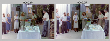
... The Map Library was moved to the new multi-purpose Records Storage building in 1992. Fortuna Villa’s 1st floor balcony facing north. ...The Map Library was moved to the new multi-purpose Records Storage building in 1992. Fortuna Villa’s 1st floor balcony facing north. ...This is a set of six photograph of a morning tea held to farewell a civilian member of the Army Survey Regiment at Fortuna Villa, Bendigo, in 1991. Although her name is not known, most personnel attending the morning team in the photos are identified. Photo .5P features the Army Survey Regiment’s Map Library located in Fortuna Villa’s Glasshouse. The Map Library was moved to the new multi-purpose Records Storage building in 1992. Fortuna Villa’s 1st floor balcony facing north. The Wayzgoose Hall named building housing the Speedmaster Printing Press is seen in the background of photo .6PThis is a set of six photograph of a morning tea held to farewell a civilian member of the Army Survey Regiment at Fortuna Villa, Bendigo, in 1991. Colour photographs are on 35mm negative film and scanned at 96 dpi. They are part of the Army Survey Regiment’s Collection. .1) - Photo, colour 1991. L to R: Tony Spurling, unidentified, Pat Graham, unidentified, MAJ Ray Redman, unidentified. .2) - Photo, colour 1991. L to R: CO LTCOL Rene van den Tol, Pat Thwaites, Tony Spurling, unidentified, Pat Graham, unidentified, MAJ Ray Redman, unidentified. .3) - Photo, colour 1991. L to R: Pat Thwaites, Tony Spurling, CO LTCOL Rene van den Tol, Pat Graham, unidentified, Norma Turner, MAJ Ray Redman. .4) - Photo, colour 1991. L to R: Norma Turner, Pat Graham, unidentified (x2). .5) - Photo, colour 1991. Army Survey Regiment’s Map Library located in Fortuna Villa’s Glasshouse. .6) - Photo, colour 1991. The mid-point of Fortuna Villa’s 1st floor balcony facing north. There are no annotationsroyal australian survey corps, rasvy, army survey regiment, army svy regt, fortuna -
 Kiewa Valley Historical Society
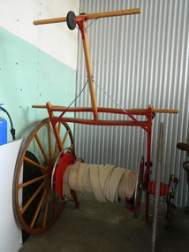
Fire Hose Reel, c1950s
... north east Victoria and state competitions involving rural and urban brigades with a difference in the equipment. Mt Beauty was/is an urban brigade whereas Tawonga is a rural brigade. Competition involved members to improve their skill, keep fit and was a very social occasion. After the Shire took over Mt Beauty township in 1961, the Fire Brigade ran by itself but soon became affiliated with the C.F.A. because of insurance and legal liability e.g.. enabling them to stop traffic or wreck buildings if required. The CFA were not happy with the Mt Beauty truck so a new...north east Victoria and state competitions involving rural and urban brigades with a difference in the equipment. Mt Beauty was/is an urban brigade whereas Tawonga is a rural brigade. Competition involved members to improve their skill, keep fit and was a very social occasion. After the Shire took over Mt Beauty township in 1961, the Fire Brigade ran by itself but soon became affiliated with the C.F.A. because of insurance and legal liability e.g.. enabling them to stop traffic or wreck buildings if required. The CFA were not happy with the Mt Beauty truck so a new ...The fire hose reel was purchased by the Fire Ladies' Auxiliary for the Mt Beauty S.E.C. Fire Brigade in the late 1950's for over 1000 pounds. Initially they competed with Bogong fire brigade as both were 'Industry' Fire brigades - both owned by the State Electricity Commission. Competition was at 2 levels - north east Victoria and state competitions involving rural and urban brigades with a difference in the equipment. Mt Beauty was/is an urban brigade whereas Tawonga is a rural brigade. Competition involved members to improve their skill, keep fit and was a very social occasion. After the Shire took over Mt Beauty township in 1961, the Fire Brigade ran by itself but soon became affiliated with the C.F.A. because of insurance and legal liability e.g.. enabling them to stop traffic or wreck buildings if required. The CFA were not happy with the Mt Beauty truck so a new one was obtained while the old one went to Bogong. Competitions gradually ceased as it was a young man's sport and young members had prior commitments. The reel was donated to the KVHS in the mid 1980's as it failed to be sold as it competed with new, cheaper, aluminium reels. The practice strip was located beside the fire station in Lakeside Avenue. This fire hose reel was used by the Mt Beauty Fire Brigade for demonstrations at competitions during the 1950's and 1960's. The Mt Beauty Fire Brigade Team won the competition in 1966 at Wangaratta. The score was close against the home team and was decided on a play off. The team benefitted by the man who wound the hose on allowing it to end up at the easiest height to handle when full of water and very heavy.The Mt Beauty Fire Brigade was an 'industry' fire brigade belonging to the State Electricity Commission of Victoria from the 1940's. It became a member of the Country Fire Authority in the early 1960's. During the 1950's and early 1960's members would compete with other local fire brigades in competitions against other brigades in the north east of Victoria using skills such as unwinding the hose off the reel and turning on the water in record time. The Mt Beauty Fire Brigade continues today as an urban fire brigade affiliated with the CFA.Varnished wooden cart reinforced by painted red steel frame. The wheels have 14 wooden spokes and steel around the outside of the wooden wheel. A long canvas hose is wound around a central winding cylinder. The cart has a wooden handle with a rubber jockey wheel at its end. There is a brass hose nozzle attached by a stainless steel frame on the outer side near one of the wheels.Each Reel: "Mt Beauty F.B." yellow print outlined in black with red background.fire hose. mt beauty fire brigade. country fire authority. fire reel. -
 Kiewa Valley Historical Society
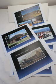
Coloured photographs on paper - Back to Tawonga 2010
... Building the New Tawonga Memorial Hall 12. Tawonga Go Kart Track - 1960s 13. Tawonga Pony Club 1969 State Championships 14. Tawonga Recreation Reserve Newspaper article 15. The Damm Children 19. 1980s Brian Edmondson, Geoff Edmondson, Mick Harvey, David Piera. Geoff Edmondson's car 20. Tawonga Speedway Track - 1970s Mick Harvey and Paul Harkin's car 21. 2000 22. Tawonga Sports Vera Ryder and Allie Briggs 23. Tawonga School Photos x8 24. Harry Cooper's Farm Looking South 25.View from Edmondson's Farm - looking north...Building the New Tawonga Memorial Hall 12. Tawonga Go Kart Track - 1960s 13. Tawonga Pony Club 1969 State Championships 14. Tawonga Recreation Reserve Newspaper article 15. The Damm Children 19. 1980s Brian Edmondson, Geoff Edmondson, Mick Harvey, David Piera. Geoff Edmondson's car 20. Tawonga Speedway Track - 1970s Mick Harvey and Paul Harkin's car 21. 2000 22. Tawonga Sports Vera Ryder and Allie Briggs 23. Tawonga School Photos x8 24. Harry Cooper's Farm Looking South 25.View from Edmondson's Farm - looking north ...These photos were collected and copied by Di Edmondson for the 'Back To Tawonga' Event in 2010 when she launched her book "Tawonga Remembers".An historical photographic collection of Tawonga and its surrounds, places and people up to 20101. Saw Mill - Mill house 2. The Rock Pool 3. People at the Rock Pool x 2 4.Old Saw mill 5. Back to Tawonga Celebrations x6 6. Tennis Curts opposite the Tawonga Store, Bakery in the background 7. Bowling Club 8. Old Guide Hall 9. The Old Boarding House 10. Old Fire Brigade Shed 11. Building the New Tawonga Memorial Hall 12. Tawonga Go Kart Track - 1960s 13. Tawonga Pony Club 1969 State Championships 14. Tawonga Recreation Reserve Newspaper article 15. The Damm Children 19. 1980s Brian Edmondson, Geoff Edmondson, Mick Harvey, David Piera. Geoff Edmondson's car 20. Tawonga Speedway Track - 1970s Mick Harvey and Paul Harkin's car 21. 2000 22. Tawonga Sports Vera Ryder and Allie Briggs 23. Tawonga School Photos x8 24. Harry Cooper's Farm Looking South 25.View from Edmondson's Farm - looking north 26. Mount Emu 27. St Aiden's Debutante Ball 27. Grand Opening Ball 1961 Tawonga Hall 28. The Kiewa Valley Road at Tawonga. Vic. 29. Tennis Courts opposite the Bogong Hotel 30.Opening of the new Toilet Block in Pioneer park 31. Old Tawonga Store x 3 32. Tawonga Memorial Hall 33. Anglican Church, St Aiden's x 2 34. Motor Khana held at Recreation reserve 35. 1970 State Champioships Team 36. Kiewa Valley School Sports at Dederang 37. Miscellaneous photos x27 Some photos have headings and some headings have been writtentawonga remembers, back to tawonga 2010, di edmondson -
 Bendigo Military Museum
Photograph - Army Survey Regiment aerial photos, Fortuna, Bendigo, 1991
... new printing building - Wazgoose Hall and the new records building. Royal Australian Survey Corps RASvy Army Survey Regiment Army Svy Regt Fortuna ASR This is a set of 32 colour aerial photographs of the Army Survey Regiment, Fortuna, Bendigo taken in 1991. Photos .1P and .2P are on photographic paper and scanned at 300 dpi. Photos .3P to .32P are on 35mm negative film and scanned at 2400 dpi. They are part of the Army Survey Regiment’s .1) - Photo, colour, 1991. Army Survey Regiment taken from the East. .2) - Photo, colour, 1991. Army Survey Regiment taken from the North ...This is a set of 32 aerial photographs of the Army Survey Regiment, Fortuna, Bendigo taken in 1991. These photos are indicative of a series of over 70 aerial photos in the collection taken from multiple angles and elevations. It is possible the photographs were taken from a hot air balloon. The approximate date of the photos is based on the existence of the new printing building - Wazgoose Hall and the new records building.This is a set of 32 colour aerial photographs of the Army Survey Regiment, Fortuna, Bendigo taken in 1991. Photos .1P and .2P are on photographic paper and scanned at 300 dpi. Photos .3P to .32P are on 35mm negative film and scanned at 2400 dpi. They are part of the Army Survey Regiment’s .1) - Photo, colour, 1991. Army Survey Regiment taken from the East. .2) - Photo, colour, 1991. Army Survey Regiment taken from the North. .3) - Photo, colour, 1991. Army Survey Regiment taken from the SSE. .4) - Photo, colour, 1991. Army Survey Regiment taken from the NE. .5) - Photo, colour, 1991. Army Survey Regiment taken from the North. .6) - Photo, colour, 1991. Army Survey Regiment taken from the South. .7) - Photo, colour, 1991. Army Survey Regiment taken from the West. .8) - Photo, colour, 1991. Army Survey Regiment taken from the South. .9) - Photo, colour, 1991. Army Survey Regiment taken from the SSW. .10) - Photo, colour, 1991. Army Survey Regiment taken from the SW. .11) - Photo, colour, 1991. Army Survey Regiment taken from the ESE. .12) - Photo, colour, 1991. Army Survey Regiment taken from the East. .13) - Photo, colour, 1991. Army Survey Regiment taken from the WSW. .14) - Photo, colour, 1991. Army Survey Regiment taken from the SSW. .15) - Photo, colour, 1991. Army Survey Regiment taken from the South. .16) - Photo, colour, 1991. Army Survey Regiment taken from the NNE. .17) - Photo, colour, 1991. Army Survey Regiment taken from the North .18) - Photo, colour, 1991. Army Survey Regiment taken from the SE. .19) - Photo, colour, 1991. Army Survey Regiment taken from the SE. .20) - Photo, colour, 1991. Army Survey Regiment taken from the NNE. .21) - Photo, colour, 1991. Army Survey Regiment taken from the ESE. .22) - Photo, colour, 1991. Army Survey Regiment taken from the ENE. .23) - Photo, colour, 1991. Army Survey Regiment taken from the NE. .24) - Photo, colour, 1991. Army Survey Regiment taken from the North. .25) - Photo, colour, 1991. Army Survey Regiment taken from the NW. .26) - Photo, colour, 1991. Army Survey Regiment taken from the South .27) & 28) - Photo, colour, 1991. Army Survey Regiment taken from the East. .29) - Photo, colour, 1991. Army Survey Regiment taken from the NNW. .30) - Photo, colour, 1991. Army Survey Regiment taken from the WNW .31) & 32) - Photo, colour, 1991. Army Survey Regiment taken from the SE.royal australian survey corps, rasvy, army survey regiment, army svy regt, fortuna, asr -
 Victoria Police Museum
Police Stations (Alexandra)
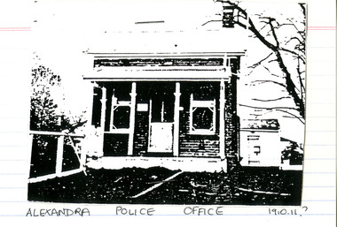
... north side near Grant Street. When the station opened it was staffed by one Senior Constable; one 1st Constable (Mounted); one Foot Constable. The original building was a nine-roomed brick building with an iron roof on land measuring 84' x 97’. The house included a wash-house, pantry, bathroom, office, one W.C., stabling for three horses, a lock-up with two rooms and a single man's room. It closed in June 1977 and was replaced by a new...north side near Grant Street. When the station opened it was staffed by one Senior Constable; one 1st Constable (Mounted); one Foot Constable. The original building was a nine-roomed brick building with an iron roof on land measuring 84' x 97’. The house included a wash-house, pantry, bathroom, office, one W.C., stabling for three horses, a lock-up with two rooms and a single man's room. It closed in June 1977 and was replaced by a new ...Alexandra is a regional centre in the Shire of Murrindindi in Victoria, Australia and 130 kilometres north east of Melbourne. Alexandra Police Station opened in the Benalla Police District on 8 May 1867 in Bon Street, on the north side near Grant Street. When the station opened it was staffed by one Senior Constable; one 1st Constable (Mounted); one Foot Constable. The original building was a nine-roomed brick building with an iron roof on land measuring 84' x 97’. The house included a wash-house, pantry, bathroom, office, one W.C., stabling for three horses, a lock-up with two rooms and a single man's room. It closed in June 1977 and was replaced by a new police station which opened on 16 June 1977 in Bon Street, on land adjacent to the old police station. For a list of Officers in Charge 1871 to 1943 contact Victoria Police Museum1 black and white photo and 3 colour photospolice stations; alexandra police station -
 Victoria Police Museum
Police Stations (Altona)
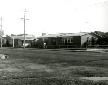
... The building consisted of a cream brick veneer police residence and police station with cell. Staff was increased to a Sergeant in Charge and 3 Constables. A new police station was opened in Altona North...The building consisted of a cream brick veneer police residence and police station with cell. Staff was increased to a Sergeant in Charge and 3 Constables. A new police station was opened in Altona North ...Altona is a suburb of Melbourne, 13 km south-west of Melbourne's CBD and located within the City of Hobsons Bay Altona Police Station opened as a temporary police station in 1919 in the Melbourne District. It was on the corner Sargood and Blyth Streets. It was staffed by one 1st Constable. The original police station was in a small room attached to the front of a 5-roomed weather-board dwelling with an iron roof on land measuring 66' x 165'. There was also a kitchen, vestibule, wash-house, office, one W.C. and a lock-up. In 1929 it became part of the Bourke District. On 31 March 1958 it moved into newly built government premises at 51-53 Blyth Street, on the corner of Bent Street. The building consisted of a cream brick veneer police residence and police station with cell. Staff was increased to a Sergeant in Charge and 3 Constables. A new police station was opened in Altona North on 7th October 1979. The Altona Police Station remained as a sub-station for a few a short time until the building was sold. July 2019 - a new police station is being constructed at 1 Galvin Street, Altona. Galvin Street was names after S/C Michael Arthur Galvin, 3651, who was appointed on 5 Jan 1886 and resigned on 4 Dec 1913. He was Werribee Shire President 1926-1927 and 1940-1941 8 black and white photos of new police station, 1963police stations; altona police station -
 4th/19th Prince of Wales's Light Horse Regiment Unit History Room
Display Binder, 2/4 Armoured Regiment Group, abt 2014
... 4th/19th Prince of Wales's Light Horse Regiment Unit History Room 4/19 PWLH Regiment, Building 78 Simpson Barracks Macleod melbourne Provides an excellent account of the service of Australian 2/4 Armoured Regiment Group in New Guinea and Bougainville in World War 2. By 1945 the United States publicity machine under General McArthur focussed on US campaigns to the North treating this action as a back water The unit's battle honours comprise South West Pacific 1945, Liberation of Australian New Guinea, Hawain River, Wewak, Wirui Mission, Slater's Knoll, Hongorai River, Egan's Ridge-Hongorai Ford, Hari River and Mivo River 2/4 Armoured Regiment is an antecedent unit of our modern Regiment ., Museum quality 3 ring, A3 size binder with clear inserts for documents and photos, in slip case. ...Provides an excellent account of the service of Australian 2/4 Armoured Regiment Group in New Guinea and Bougainville in World War 2. By 1945 the United States publicity machine under General McArthur focussed on US campaigns to the North treating this action as a back water The unit's battle honours comprise South West Pacific 1945, Liberation of Australian New Guinea, Hawain River, Wewak, Wirui Mission, Slater's Knoll, Hongorai River, Egan's Ridge-Hongorai Ford, Hari River and Mivo River2/4 Armoured Regiment is an antecedent unit of our modern Regiment ., Museum quality 3 ring, A3 size binder with clear inserts for documents and photos, in slip case. Presents history of Australian 2/4 Armoured Group in South West Pacific in World War 2 -
 Orbost & District Historical Society
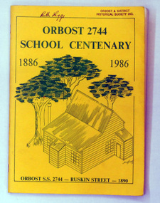
book, Orbost 2744 School Centenary 1886 1986, 1986
... new school at Orbost North was welcomed by all concerned. In 1963 the Department purchased land diagonally opposite the school and developed it as a playing area. In 1965 two LTCs were opened in November, and in October 1968 the Brodribb School building was moved to SS2744 Orbost for use as a general purpose room. ...new school at Orbost North was welcomed by all concerned. In 1963 the Department purchased land diagonally opposite the school and developed it as a playing area. In 1965 two LTCs were opened in November, and in October 1968 the Brodribb School building was moved to SS2744 Orbost for use as a general purpose room. ...2228.1 belonged to Ruth Legge. 2228.2 belonged to Mary Gilbert. This book was produced as a souvenir history of Orbost Primary School. The Orbost State School opened on 19th of March 1886 .The school had first operated temporarily in a leased building, and on a half-time basis with SS2745 Jarrahmond. The first head teacher was HT Campbell Mackay. However he remained in charge only until 12th of May 1886. The second HT, John Rowe, served until 1908. On 30th of June 1887, a portable room was provided; it being brought to the area by schooner. The school then had accommodation for 30 pupils; the teacher's welfare was considered because quarters of two rooms were attached. As the population increased so did the needs of the school. This was reflected in the provision of a larger classroom in 1898. During 1910-11 the first approaches were made to the Department for the establishment of a HES in Orbost and this became a reality in 1912. Orbost HES supplied post-primary education in the district until a high school was built in 1948. When fire destroyed the school in 1941 local halls were used as classrooms until a new school was built. Work was quite rapid and a new brick structure was opened by the Hon. A. E. Lind, MLA, on 13th of February 1942. The head teacher then was Leslie Collins. Orbost continued to develop and the new school was soon overtaxed. This resulted in the erection of two Bristol classrooms in 1947. By 1950, when the school population had reached 500 pupils the opening of the new school at Orbost North was welcomed by all concerned. In 1963 the Department purchased land diagonally opposite the school and developed it as a playing area. In 1965 two LTCs were opened in November, and in October 1968 the Brodribb School building was moved to SS2744 Orbost for use as a general purpose room. This book is a useful research resource.Two copies of a yellow paper book book. On the front cover is a sketch of some trees beneath the title which is in green print ( these are the school colours) . This is a souvenir record of the history of Orbost Primary School.2228.1 has autographs on the back fly.orbost-primary-school book orbost-history -
 Ballarat Clarendon College
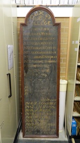
Honour board, Dux of College
... building north wing). Two of the boards are featured in 1918 photographs of the Assembly Hall. The three boards cover the following years: 1868 - 1895 (partially defaced), 1896 - 1921 (completely defaced) and 1922 - 1952 (complete). New...building north wing). Two of the boards are featured in 1918 photographs of the Assembly Hall. The three boards cover the following years: 1868 - 1895 (partially defaced), 1896 - 1921 (completely defaced) and 1922 - 1952 (complete). New ...These were the first honour boards created by Ballarat College to honour the top academic student of each year. The first award was given in 1868 four years after the school opened. The boards were one display in the Assembly Hall (Sturt Street building north wing). Two of the boards are featured in 1918 photographs of the Assembly Hall. The three boards cover the following years: 1868 - 1895 (partially defaced), 1896 - 1921 (completely defaced) and 1922 - 1952 (complete). New boards replacing these boards were created prior to the centenary celebration in 1964 and hung in the Memorial Hall. At amalgamation (1974) and because the Senior students moved to the Mair Street campus) these boards were co-opted to honour Middle School Dux and Junior Captains. In 2012 the school undertook a major project and created three new boards. One board honours Ballarat College Dux (1868 - 1973) and School Captains (1914 - 1973); another board honours Clarendon Presbyterian Ladies' College Dux and Head Prefect (1919 - 1973). These boards resemble the 1950 re-creation. A third board was instituted in 2012 to honour Ballarat Clarendon College Dux and School Captains (1974 - )Academic excellence and leadership are significant values for the current school and its two predecessors. These boards emphasize the great honour that is afforded to students who excell individually in these areas. Three wooden boards with decorative wood framing and arched or curved top edges and white lettering. Two boards are painted black. One board has mahogany timber stain. ballarat-college, clarendon-presbyterian-ladies-college, ballarat-and-clarendon-college, school-captain, prefect, honour-board, 1968, 1964, 1974, 1973, leadership, dux -
 Ballarat Clarendon College
Honour board, Ballarat College Dux
... building north wing). They are featured in 1918 photographs of the Assembly Hall. The three boards cover the following years: 1868 - 1895 (partially defaced), 1896 - 1921 (completely defaced) and 1922 - 1952 (complete). This new...building north wing). They are featured in 1918 photographs of the Assembly Hall. The three boards cover the following years: 1868 - 1895 (partially defaced), 1896 - 1921 (completely defaced) and 1922 - 1952 (complete). This new ...This was the second honour board created by Ballarat College to honour the top academic student of each year. The first award was given in 1868 four years after the school opened. Dux of College honour boards were on display in the Assembly Hall (Sturt Street building north wing). They are featured in 1918 photographs of the Assembly Hall. The three boards cover the following years: 1868 - 1895 (partially defaced), 1896 - 1921 (completely defaced) and 1922 - 1952 (complete). This new board replacing the originals were created prior to the centenary celebration in 1964 and hung in the Memorial Hall. At amalgamation (1974) and because the Senior students moved to the Mair Street campus) this board was co-opted to honour Middle School Dux. In 2012 the school undertook a major project and created three new boards. One board honours Ballarat College Dux (1868 - 1973) and School Captains (1914 - 1973); another board honours Clarendon Presbyterian Ladies' College Dux and Head Prefect (1919 - 1973). These boards resemble the 1950 re-creation. A third board was instituted in 2012 to honour Ballarat Clarendon College Dux and School Captains (1974 - ) This board emphasizes the value placed on academic excellence by the school from its earliest beginnings. That the boards have been maintained and consistently displayed in significant places of honour within the school only further emphasizes the historial and social significance of the award 'Dux of school'. Large varnished wooden board with wood frame, four rectangular relief boards and one heading relief board. Gold leaf lettering on relief boards. dux, ballarat-college, ballarat-and-clarendon-college, honour-boards, memorial-hall, assembly-hall, 1968, 1918, 1974, middle-school-dux -
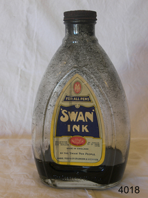 Flagstaff Hill Maritime Museum and Village
Container - Ink bottle, MABIE TODD & Co. (Aust.) Pty. Ltd, Second half of 19th Century or first half of the 20th Century
... Another new headquarters grew out of this period of abundance and market domination. when in 1936 they moved into Sunderland House in Mayfair, London, a highly prized mansion building. Disaster struck early in the Second World War. Its prestigious Sunderland House headquarters was destroyed during the blitz, followed by destruction of its main factory in Harlesden, North...Another new headquarters grew out of this period of abundance and market domination. when in 1936 they moved into Sunderland House in Mayfair, London, a highly prized mansion building. Disaster struck early in the Second World War. Its prestigious Sunderland House headquarters was destroyed during the blitz, followed by destruction of its main factory in Harlesden, North ...A Brief History Of Mabie Todd Ltd The company originated in America from the beginnings during the 1860s when a Mr. Todd and a Mr. Mabie began making pencil cases and pen holders in New York. Later they were joined by the Bard Brothers who made Gold nibs and by 1873 the company of Mabie Todd and Bard were established in New York. By 1878 the first patent was filed for the design and manufacture of a fountain pen, achieved under the design leadership of one William Washington Stewart. The first Swan fountain pen followed just 6 years later in 1884 with an over-under feed with ink delivery assisted by a twisted silver wire. This same year an office had been established in the UK with a showroom in Cheapside, London. The UK was being supplied with a steadily increasing supply of pens from New York and by 1905 new, larger showrooms were established in High Holborn. By this time the Swan pen had become synonymous with fountain pens at large. In 1906 the name of Bard was dropped in the US and the UK company subsequently adopted the title Mabie Todd & Co. New York. In 1907 British production began, using imported nibs from New York and whilst the company in the UK flourished, the business in the US started to diminish under stiff competition from new manufacturers.. By 1915 manufacturing was doing well in England from a factory in Weston Street, London and the New York company agreed to sell the rights to all European and Colonial business to Mabie Todd & Company Ltd of England. From then onwards, the development of the range mostly followed, rather than led the interests of the markets they were supplying. Even during the First World War the business continued to flourish. with factories in both London and Liverpool. At the end of 1919 a new expansion plan saw the establishment of a new Headquarters in Oxford Street, London. Throughout this period, some components were continuing to be imported from America, but gradually these diminished and during the 20s and 30s manufacturing facilities were expanded and by the end of the 1930s Mabie Todd were in full production, manufacturing pens in its London factory, gold nibs in Birmingham and ink in Liverpool. Another new headquarters grew out of this period of abundance and market domination. when in 1936 they moved into Sunderland House in Mayfair, London, a highly prized mansion building. Disaster struck early in the Second World War. Its prestigious Sunderland House headquarters was destroyed during the blitz, followed by destruction of its main factory in Harlesden, North London. Some machinery was saved and able to be used at another factory premises in the City, but like many other 'non essential' manufacturing, the main production was centred on wartime components such as rocket fuses and ammunition. After The War, in 1945 they moved out of their City premises to Park Royal and eventually in 1946 proper fountain pen production was resumed. In 1948 the company decided to go public. But at the time they had no plans to enter into the market for the now growing interest in ballpoint pens, the result was the beginning of their slide into obscurity and subsequent demise. They became Biro Swan in 1952 following a large share purchase by Biro Pens. Even though at this time they had just launched their new high profile Calligraph range to join the competition for the new market associated with a craze for italic writing, fountain pen manufacture under the new company was to suffer a lack of real support. The restyled ranges of 1956 failed to ignite market interest and with diminishing quality, the end of the Mabie Todd story was inevitable. After 80 years of Swan pens, the book was closed.This bottle of ink would have been supplied to schools. After a child was deemed old enough to progress from just using slate and board, he/she would have been supplied with a pen shaft made of wood and with a very basic metal nib. The ink bottle would be used to fill up the individual inkwells. This operation would have been conducted by the teacher him/herself, or by an older pupil under the close eye of the teacher.Ink bottle clear glass with 'Swan Ink' paper label. Has rusted screw on top & black ink inside.Label has 'Mabel Todd' manufacturer's logo at top,; 'Swan Ink' name clearly shown; 'Made in England' printed clearly; and 'Mable Todd & Co Ltd, London & Liverpool' printed at base of label.flagstaff hill, warrnambool, shipwrecked-coast, flagstaff-hill, flagstaff-hill-maritime-museum, maritime-museum, shipwreck-coast, flagstaff-hill-maritime-village, ink, bottle, mabie todd ltd -
 Federation University Historical Collection
Photographs - Colour, Trav Munro, Federation University Camp Street Campus, 2016, 2016
... Colour photographs by Trav Munro of buildings at the Federation University Camp Street Campus, including the former Ballarat Post Office (now Post Office Gallery), Former Law Courts (State Offices), New South, New North...Barker Library (top floor) Mount Helen goldfields trav munro federation university australia Camp Street Arts academy Post Office Gallery post office gallery former ballarat post office former ballarat law courts former ballarat state offices New north new south Old Sheriff's Office Colour photographs by Trav Munro of buildings at the Federation University Camp Street Campus, including the former Ballarat Post Office (now Post Office Gallery), Former Law Courts (State Offices), New South, New North Federation University Camp Street Campus, 2016 Photographs - Colour Trav Munro ...Colour photographs by Trav Munro of buildings at the Federation University Camp Street Campus, including the former Ballarat Post Office (now Post Office Gallery), Former Law Courts (State Offices), New South, New Northtrav munro, federation university australia, camp street, arts academy, post office gallery, post office gallery, former ballarat post office, former ballarat law courts, former ballarat state offices, new north, new south, old sheriff's office -
 Wycheproof & District Historical Society Inc.
Photograph, St Andrew's Presbyterian Church Complex
... building of a church. The first church was in Charles Street on the north side of the Mount. It served the congregation for twenty years. The new...building of a church. The first church was in Charles Street on the north side of the Mount. It served the congregation for twenty years. The new ...The first Presbyterian gathering was held in Wycheproof in 1876, this led to the organization of a congregation and the building of a church. The first church was in Charles Street on the north side of the Mount. It served the congregation for twenty years. The new church in Mount Street opened 06-09-1896 and after 115 years the doors closed for worship in 2011.A building of spiritual and social significance to the Presbyterian congregation and wider community of Wycheproof and District for 115 years.Small format sepia print taken between 1912-1937of the Wycheproof Presbyterian Church Complex. Designed on early English lines, the church dated 1896 was built of red-brick with buttresses and decorated cream-brick trimmings. The arched windows are glazed in diamond shaped leadlight. The high pitched roof is of galvanized corrugated iron. The Sunday School Hall 1912, of timber construction with feature trim of arched windows and doors and a galvanized corrugated iron roof. The Manse 1909, of timber construction with galvanized corrugated iron roof and fret-work on the space above the verandah. Iron lace decorates the wooden verandah posts. Fencing: Post and Rail. Kodak print /501presbyterian, church, sunday school, manse, building, 1896, post and rail fence, red-brick, timber -
 Eltham District Historical Society Inc
Photograph, Tess Justine (Nillumbik Shire Council), Murray's Bridge over the Diamond Creek, Eltham North, 19 Feb 2022
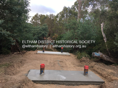
... North who apart from further scarring the face of the earth over the previous two years had gained significant experience but little gold - hardly a driving factor for constructing a dedicated railway siding and bridge to transfer gold ore. It is far more probable that James Murray was hoping to have the railway station located on his property and invested his money by building the bridge to lead to it as well as a station platform. Had the station eventuated, it may well have driven up the value of his land for subdivision and new...North who apart from further scarring the face of the earth over the previous two years had gained significant experience but little gold - hardly a driving factor for constructing a dedicated railway siding and bridge to transfer gold ore. It is far more probable that James Murray was hoping to have the railway station located on his property and invested his money by building the bridge to lead to it as well as a station platform. Had the station eventuated, it may well have driven up the value of his land for subdivision and new ...Murray's Bridge over the Diamond Creek on the Diamond Creek Trail just prior to demolition and replacement with a new steel bridge. Heritage advice obtained by Nillumbik Shire Council, following a suggestion by the Eltham District Historical Society (EDHS), is that the original bridge appears to have been a simplified version of the Country Roads Board’s (CRB) standard timber bridge design of the early-to-mid 1920s. In c1990 Murray’s bridge was renovated with three recycled steel girders as part of a bike/pedestrian path in the reserve. During these alterations many parts of the bridge were removed, and some were replaced. Heritage advice indicates the condition of Murray’s bridge is poor. The remaining original parts are all in poor condition, with severe weathering, splitting and rot, especially to the stringers retained on the bridge. Heritage advice is that Murray’s Bridge does not have sufficient significance in the cultural history of the Nillumbik area to warrant inclusion in the Nillumbik Shire Heritage Overlay and also does not have sufficient significance as a rare survivor to warrant inclusion in the Nillumbik Shire Heritage Overlay. There are no indications in the historical record that this site was individually important to the cultural history of this area. EDHS is comfortable with the heritage advice provided to Council and has worked closely on this project with Council. EDHS has suggested some of the removed timbers be used in the vicinity of the bridge for landscaping and possibly seating, so as to retain these remnants close to the site of the original bridge, which is the last old timber bridge along the lower reaches of the Diamond Creek. Mary (Sweeney) Murray and John Wright Murray selected 80 acres, Lot C Section 16 and Lot 5 Section 17 Parish of Nillumbik, under an occupation license in 1866. John died in 1867 and freehold was granted to his son John in 1873. The farm was known as ‘Laurel Hill’. John Junior was an Eltham Shire councillor and sometime president from 1887 up until 1897. He added Lot A Section 16 to the farm in ca1888. John and his younger brother James arranged to rent/purchase Lot B Section 17, across Diamond Creek to the west, in ca1900. It appears that John and James farmed separately for a few years, with a new homestead built for James ad family on the high point of Lot B Section 17 in ca1910. John sold off Lot 5 Section 17 in 1912. When John died in 1912 James took over the land on both sides of the Diamond Creek. The old homestead on the west side of the Creek disappeared. A farm bridge over Diamond Creek from this period may have been located close to the northern boundary of the farm. John Langlands, owner of the farm known as ‘Ihurst’ on the west side of Diamond Creek to the south of the Murray’s land, died in 1907. In 1909 his land was then subdivided into 100 lots to become the ‘Glen Park Estate’. Other similar subdivisions of nineteenth century farms around Eltham in this period included the ‘Franktonia (or Beard’s) Estate’ to the northeast and ‘Bonsack’s Estate’ between Eltham and Greensborough. Soon after the opening of the railway extension line from Eltham to Hurstbridge in 1912, Glen Park and nearby residents including James Murray agitated for a railway station or siding to be located half-way between Eltham and Hurstbridge, so that the Glen Park residents who used the railway daily did not have to walk into the Eltham or Hurstbridge stations. Some believed Coleman’s Corner (opposite Edendale Farm) was an appropriate spot for the platform. James Murray was among those who thought the railway should be located on his land, closer to half-way between Eltham and Hurstbridge stations. The Railways Commissioners warned that the locals would have to fund these works themselves. The Glen Park Estate residents initially had difficulty accessing Eltham by road, with only an old low-level bridge over Diamond Creek at the south end of their estate. A new timber trestle bridge across the creek, now on Wattletree Road, was opened in 1915. Road access to the north was gained in 1927 when the new Murray’s Road, which crossed the Murray’s land, was built. Residents continued to agitate for a Glen Park station. By 1926 the Railways Commissioners’ preferred site was on the Murray’s land. They arranged an estimate of cost of a full-length platform. The estimate was too much for the locals, who in 1928 argued unsuccessfully for a shorter and hence cheaper platform. By 1929 Murray had agreed to donate the land, but the locals would still have to fund the works. Murray decided, unilaterally it would appear, to commence work on a timber trestle road bridge over Diamond Creek to link the new Murray Road to the proposed station. Late in 1929 he stopped work on the bridge, for reasons unknown, but started work again and completed the bridge in 1931. There is no further newspaper evidence of the campaign for the Glen Park station until 1939, when Murray and another local, Mr Maxwell, met the Railways Commissioner. The Glen Park locale now included 45 homes on the west side of the creek and 20 on the Eltham side. Most of the residents used the train every day. The Commissioner remained adamant that only a full-length platform could be built for safety reasons. It appears the campaign dissolved at this point. The increasing move to cars may have had an impact. There is no evidence of Murray’s bridge ever being connected to Murray’s Road, or of it having wide use for any purpose by locals. James Murray died in 1947 and the farm was taken over by his son James (Jim). Jim started to sell off parts of the farm in the 1980s, retaining a few acres around the ca1910 homestead and building a new house there. Recreation reserves were established along the creek. In ca1990 Murray’s bridge was renovated with steel girders as part of a bike/pedestrian path in the reserve. The old farmhouse was demolished in ca2014. * * * A theory posted on local community Facebook groups was that the bridge was built in the 1860s and was built to be more robust than was necessary for the movement of cows from one side of the creek to the other. It was suggested the robustness was necessary to support the weight of gold ore being transferred from a mine on Murray’s land to a railway siding near Murrays Bridge (presumably for transfer and processing at Diamond Creek). Perhaps this may have been one of the motivators for Murray, who really knows? Knowing when mining operations ceased on his land and how that fits the overall timeline would be useful but at the time the bridge was built, local gold production was minimal at best. The known facts are: • The railway line came to Eltham in 1902. • The extension of the railway from Eltham to Hurstbridge was constructed in 1912 so no railway line even existed through Murray's property until 1912 and the Victorian Railways maps at the time show no such siding on Murray’s property. • In 1923 a new company was formed in anticipation of the old Diamond Creek Gold Mine being re-opened. The mine had been previously closed and flooded. It was noted in the press at the time that the mine was within a mile of the railway. Nothing really came of this. • Construction of Murrays Bridge was commenced by James Murray in early 1929 in anticipation of a proposed flag station being nominated on his land, but work ceased shortly afterwards. The proposed flag station was commonly referred to as Glen Park as the residents of the Glen Park Estate wanted Option 1, located near them with the platform adjacent to Colemans corner. This was probably never going to fly as it was virtually in eyesight of Eltham station. Allandale Road was the third option, but the Commissioners' preferred option was No. 2 - on Murray's property. • The Railway Commissioners were not going to finance any such station and the works had to be funded by private landowners and residents, hence Murray investing in this himself. • Murray recommenced work two years later and finished his bridge in 1931 but unfortunately for him, the proposed flag station never eventuated. The bluestone siding you reference may well have been built by Murray as part of the proposed station platform. • Up until then, apart from the Main Road bridge, which was washed away in 1924, virtually all local crossings over the Diamond Creek were low lying bridges – Kaylocks Bridge at Brougham Street, Diamond Street bridge, Glen Park Road bridge. It is expected that Murray also had a low-lying bridge to connect his land either side of the creek. These were all washed away or severely damaged multiple times in the 1920s. Lessons were learnt, and Murrays Bridge appears to have been built in accordance with Country Road Board standards of the time. Flood damage was ongoing, and even more recently constructed raised bridges kept getting washed away, e.g., the new Wattle Tree Road bridge in 1958 just months after completion. Murray’s bridge was reinforced with steel some 30 years ago presumably to provide additional floodwater resistance, given the history of bridges disappearing in floodwaters. • In March 1932 it was reported in the Advertiser that there were still some prospectors operating around Eltham North who apart from further scarring the face of the earth over the previous two years had gained significant experience but little gold - hardly a driving factor for constructing a dedicated railway siding and bridge to transfer gold ore. It is far more probable that James Murray was hoping to have the railway station located on his property and invested his money by building the bridge to lead to it as well as a station platform. Had the station eventuated, it may well have driven up the value of his land for subdivision and new housing estates like the Glen Park Estate. That did not eventuate. Whilst the bridge was indeed old (90 years), the core structure being completed in 1931, it had been modified substantially from original and hence had no significant historic value – i.e., it was not a representative example of its type, construction, and age. Given that the bridge was not worthy of saving, the Eltham District Historical Society with Council’s support, and the Eltham Woodworkers group endeavoured to see what suitable sized timbers were salvageable to fabricate a commemorative seat. Unfortunately, the experts at the Woodworkers group were unable to salvage any suitable length/width timbers to fabricate the seat due to the presence of rot. Last remaining wooden trestle bridge on the Diamond Creek Trail just prior to demolition and replacementBorn digital image (27)diamond creek (creek), diamond creek trail, murrays bridge, ‘laurel hill’, john wright murray, mary (sweeney) murra, john murray jnr, james murray, john langlands, ‘ihurst’, ‘glen park estate’, beard's estate, franktonia, bonsack's estate, glen park estate, glen park railway station -
 Eltham District Historical Society Inc
Photograph, Tess Justine (Nillumbik Shire Council), Construction work on replacement of Murray's Bridge over the Diamond Creek, Eltham North, 31 Mar 2022
... building a new house there. Recreation reserves were established along the creek. In ca1990 Murray’s bridge was renovated with steel girders as part of a bike/pedestrian path in the reserve. The old farmhouse was demolished in ca2014. Diamond Creek (Creek) diamond creek trail murrays bridge ‘Laurel Hill’ John Wright Murray Mary (Sweeney) Murra John Murray jnr James Murray John Langlands ‘Ihurst’ ‘Glen Park Estate’ Beard's Estate Franktonia Bonsack's Estate Glen Park Estate Glen Park Railway Station Born digital image (5) Construction work on replacement of Murray's Bridge over the Diamond Creek, Eltham North Photograph Photograph Tess Justine (Nillumbik Shire Council) ...Construction work on replacement of Murray's Bridge over the Diamond Creek on the Diamond Creek Trail Mary (Sweeney) Murray and John Wright Murray selected 80 acres, Lot C Section 16 and Lot 5 Section 17 Parish of Nillumbik, under an occupation license in 1866. John died in 1867 and freehold was granted to his son John in 1873. The farm was known as ‘Laurel Hill’. John Junior was an Eltham Shire councillor and sometime president from 1887 up until 1897. He added Lot A Section 16 to the farm in ca1888. John and his younger brother James arranged to rent/purchase Lot B Section 17, across Diamond Creek to the west, in ca1900. It appears that John and James farmed separately for a few years, with a new homestead built for James ad family on the high point of Lot B Section 17 in ca1910. John sold off Lot 5 Section 17 in 1912. When John died in 1912 James took over the land on both sides of the Diamond Creek. The old homestead on the west side of the Creek disappeared. A farm bridge over Diamond Creek from this period may have been located close to the northern boundary of the farm. John Langlands, owner of the farm known as ‘Ihurst’ on the west side of Diamond Creek to the south of the Murray’s land, died in 1907. In 1909 his land was then subdivided into 100 lots to become the ‘Glen Park Estate’. Other similar subdivisions of nineteenth century farms around Eltham in this period included the ‘Franktonia (or Beard’s) Estate’ to the northeast and ‘Bonsack’s Estate’ between Eltham and Greensborough. Soon after the opening of the railway extension line from Eltham to Hurstbridge in 1912, Glen Park and nearby residents including James Murray agitated for a railway station or siding to be located half-way between Eltham and Hurstbridge, so that the Glen Park residents who used the railway daily did not have to walk into the Eltham or Hurstbridge stations. Some believed Coleman’s Corner (opposite Edendale Farm) was an appropriate spot for the platform. James Murray was among those who thought the railway should be located on his land, closer to half-way between Eltham and Hurstbridge stations. The Railways Commissioners warned that the locals would have to fund these works themselves. The Glen Park Estate residents initially had difficulty accessing Eltham by road, with only an old low-level bridge over Diamond Creek at the south end of their estate. A new timber trestle bridge across the creek, now on Wattletree Road, was opened in 1915. Road access to the north was gained in 1927 when the new Murray’s Road, which crossed the Murray’s land, was built. Residents continued to agitate for a Glen Park station. By 1926 the Railways Commissioners’ preferred site was on the Murray’s land. They arranged an estimate of cost of a full-length platform. The estimate was too much for the locals, who in 1928 argued unsuccessfully for a shorter and hence cheaper platform. By 1929 Murray had agreed to donate the land, but the locals would still have to fund the works. Murray decided, unilaterally it would appear, to commence work on a timber trestle road bridge over Diamond Creek to link the new Murray Road to the proposed station. Late in 1929 he stopped work on the bridge, for reasons unknown, but started work again and completed the bridge in 1931. There is no further newspaper evidence of the campaign for the Glen Park station until 1939, when Murray and another local, Mr Maxwell, met the Railways Commissioner. The Glen Park locale now included 45 homes on the west side of the creek and 20 on the Eltham side. Most of the residents used the train every day. The Commissioner remained adamant that only a full-length platform could be built for safety reasons. It appears the campaign dissolved at this point. The increasing move to cars may have had an impact. There is no evidence of Murray’s bridge ever being connected to Murray’s Road, or of it having wide use for any purpose by locals. James Murray died in 1947 and the farm was taken over by his son James (Jim). Jim started to sell off parts of the farm in the 1980s, retaining a few acres around the ca1910 homestead and building a new house there. Recreation reserves were established along the creek. In ca1990 Murray’s bridge was renovated with steel girders as part of a bike/pedestrian path in the reserve. The old farmhouse was demolished in ca2014. Born digital image (5)diamond creek (creek), diamond creek trail, murrays bridge, ‘laurel hill’, john wright murray, mary (sweeney) murra, john murray jnr, james murray, john langlands, ‘ihurst’, ‘glen park estate’, beard's estate, franktonia, bonsack's estate, glen park estate, glen park railway station -
Glen Eira Historical Society
Document - CAULFIELD RSL
... new construction must take into account. Included is a black-and-white map of Caulfield noting the RSL’s location, and two black-and-white photographs showing the view to the north and south of St. George’s Road, respectively. Caulfield Caulfield Returned Servicemen League (RSL) exservice organisations Clubs and Associations Ward Andrew Glen Eira Heritage Management Plan Historic Buildings Architectural Styles National Trust Company St. ...This file contains two items pertaining to the property housing the Caulfield RSL: 1/A photocopy (2 pages) of an assessment of the property, dated 01/1997, by Andrew Ward, for purposes of ascertaining its historical significance. The assessment describes the architectural features of the property, offers a brief history of it, specifies why it should be considered significant, and recommends that it be added to the National Estate Register. Included is a black-and-white photograph of the exterior of the building. 2/An assessment (17 long pages plus appendix) of the car parking issues procured as a result of the decision to refurbish the Caulfield RSL. Prepared by Grogan Richards Pty Ltd, dated 13/11/2002, reviewed by Joanna Gauetty, and authorised by Rody Jude. Included is a description of the Club’s location and surrounding motorways as they existed at the time, a description of the Club itself (eg its opening hours and rate of patronage as per each opening hour), occupancy surveys, descriptions of other recent car parking construction within the same area, a description of the extensions the RSL is aiming to construct, and descriptions of the considerations any new construction must take into account. Included is a black-and-white map of Caulfield noting the RSL’s location, and two black-and-white photographs showing the view to the north and south of St. George’s Road, respectively.caulfield, caulfield returned servicemen league (rsl), exservice organisations, clubs and associations, ward andrew, glen eira heritage management plan, historic buildings, architectural, styles, national trust company, st. leonard’s, elsternwick club, grogan richards pty ltd, returned servicepeople, armed forces, soldiers, aged people, senior citizens centres, st. george’s road, elsternwick, english domestic revival style, moderne style, brick houses, bay windows, architectural features, prendergast ellen mrs., ford grylis, dl design group, gauetty joanna, jude rody, parking, glen eira planning scheme -
 Eltham District Historical Society Inc
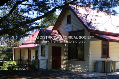
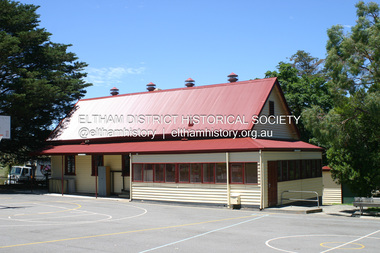
Photograph - Digital Photograph, Alan King, Original Kangaroo Ground Primary School No. 2105 building, Eltham-Yarra Glen Road, Kangaroo Ground, 28 December 2007
... new school building with a storeroom and staffroom was built in 1974. This collection of almost 130 photos about places and people within the Shire of Nillumbik, an urban and rural municipality in Melbourne's north, contributes to an understanding of the history of the Shire. ...Kangaroo Ground's first school began in 1851 with 22 pupils from the district's ten families. It was a single room school located further south on the site, which also served as a Presbyterian church. The first teacher was Andrew Ross. The school building was used as a Post Office between 1854 and 1858 and during 1857 also served as a Court of Petty Sessions. With a growing farming community, a new building was warranted and the original Sate School No. 352 was closed and a new building, State School No. 2105 was oipened October 1, 1878. A residence for Head Teacher Henry Wallace School was erected in 1879 attached to the left of the school building. That residence is now home to the Andrew Ross Museum, which opened in 1993. Covered under Heritage Overlay, Nillumbik Planning Scheme. Published: Nillumbik Now and Then / Marguerite Marshall 2008; photographs Alan King with Marguerite Marshall.; p35 In a corner of the Kangaroo Ground Primary School playground stands an old weatherboard building. This structure, attached to the former teacher’s weatherboard residence facing Main Road, first served as a school in 1878. The former residence, built in 1879, houses the Andrew Ross Museum, which opened in 1993. It is named after the school’s first teacher,1 who also founded The Evelyn Observer newspaper, which began on the site in 1873. Later the printing presses were moved to brick newspaper offices by the Kangaroo Ground Hotel, which became the Shire of Eltham offices. However Kangaroo Ground’s first school began in 1851 for 22 pupils from the district’s ten families, in a slab building further south on this site. Andrew Harkness and other settlers campaigned for the building, which was built on half an acre (0.2ha) donated by local farmer, James Donaldson. Builder was Samuel Furphy, father of the novelist Joseph.2 The single room measuring 30 feet x 18 feet (9m x 5.5m), was unlined and the green slabs shrank, allowing the wind and rain entry through cracks except when they were stuffed with paper.3 The building served as a Presbyterian church as well as a school, where fees were 18 pence a week for education. Young men also attended evening classes there in winter. At one stage, a corner of the room was curtained off for the schoolmaster’s living space, and the platform, which was used for sleeping, was also the pulpit during church services. Teacher Andrew Ross also took church services when the minister was unable to attend, which happened frequently as he had long distances to travel on the bad roads. In 1857 the school building was also used as the Court of Petty Sessions, and from 1854 until 1858, it served as a post office. During the gold rush fossickers on their way to the Caledonia Diggings at Queenstown (now St Andrews) prospected the district, but did not remain long, as the fields were not rich in gold. But the farming community grew, until by 1878 the population warranted the building of State School No 2105 – the present one-roomed tongue-and-groove lined building measuring 49 feet x 18 feet (15m x 5.5m), to accommodate 60 children. The old school, No 352, was closed, and the new one opened on October 1, with Henry Wallace as head teacher, assisted by work mistress Annie Johnston. Early teachers included Messrs Smith, Hamilton and Prosser, with sewing teachers Misses Sweeney, Limerock and Oliver. In the early 1920s a small room was built on the front veranda of the teacher’s residence, and used as a State Savings Bank agency until about 1934. In 1928 the schoolroom’s three-tiered floor was replaced by a flat floor and teacher’s platform (which has since been removed). A half-glassed partition wall then divided the large room into two rooms in which the old style form-type desks were replaced with dual desks. The small playground, surrounded by pine trees and a picket fence, was extended in 1931 with an additional acre or so (0.4 ha) of land. During World War Two the school faced closure because of a fall to seven in the enrolment, but by 1946 it had increased again to 45. Mr Eric Morgan was head teacher and Mrs Margaret Banks was assistant head teacher, a position she held for ten years. In 1955, under the head teacher Mr V Gardiner, who taught there for 13 years, the school won a prize for the best-kept garden and school ground in the inspectorate. A district subdivision increased the enrolment in 1968 to 65 and a bus service was established. After the hall which had been used for lessons was demolished late that year, the pupils met in the original fire brigade meeting room (now the tennis club, diagonally opposite the general store). The new school building with a storeroom and staffroom was built in 1974.This collection of almost 130 photos about places and people within the Shire of Nillumbik, an urban and rural municipality in Melbourne's north, contributes to an understanding of the history of the Shire. Published in 2008 immediately prior to the Black Saturday bushfires of February 7, 2009, it documents sites that were impacted, and in some cases destroyed by the fires. It includes photographs taken especially for the publication, creating a unique time capsule representing the Shire in the early 21st century. It remains the most recent comprehenesive publication devoted to the Shire's history connecting local residents to the past. nillumbik now and then (marshall-king) collection, kangaroo ground, andrew ross museum, eltham-yarra glen road, kangaroo ground primary school no. 2105, kangaroo ground state school, state school no. 2105 -
 Eltham District Historical Society Inc
Photograph - Digital Photograph, Alan King, Original Kangaroo Ground Primary School No. 2105 building, Eltham-Yarra Glen Road, Kangaroo Ground, 28 December 2007
... new building, State School No. 2105 was oipened October 1, 1878. A residence for Head Teacher Henry Wallace School was erected in 1879 attached to the left of the school building. That residence is now home to the Andrew Ross Museum, which opened in 1993. Covered under Heritage Overlay, Nillumbik Planning Scheme. Published: Nillumbik Now and Then / Marguerite Marshall 2008; photographs Alan King with Marguerite Marshall.; p35 This collection of almost 130 photos about places and people within the Shire of Nillumbik, an urban and rural municipality in Melbourne's north, contributes to an understanding of the history of the Shire. ...Kangaroo Ground's first school began in 1851 with 22 pupils from the district's ten families. It was a single room school located further south on the site, which also served as a Presbyterian church. The first teacher was Andrew Ross. The school building was used as a Post Office between 1854 and 1858 and during 1857 also served as a Court of Petty Sessions. With a growing farming community, a new building was warranted and the original Sate School No. 352 was closed and a new building, State School No. 2105 was oipened October 1, 1878. A residence for Head Teacher Henry Wallace School was erected in 1879 attached to the left of the school building. That residence is now home to the Andrew Ross Museum, which opened in 1993. Covered under Heritage Overlay, Nillumbik Planning Scheme. Published: Nillumbik Now and Then / Marguerite Marshall 2008; photographs Alan King with Marguerite Marshall.; p35This collection of almost 130 photos about places and people within the Shire of Nillumbik, an urban and rural municipality in Melbourne's north, contributes to an understanding of the history of the Shire. Published in 2008 immediately prior to the Black Saturday bushfires of February 7, 2009, it documents sites that were impacted, and in some cases destroyed by the fires. It includes photographs taken especially for the publication, creating a unique time capsule representing the Shire in the early 21st century. It remains the most recent comprehenesive publication devoted to the Shire's history connecting local residents to the past. nillumbik now and then (marshall-king) collection, kangaroo ground, eltham-yarra glen road, kangaroo ground primary school no. 2105, kangaroo ground state school, state school no. 2105 -
 Eltham District Historical Society Inc
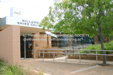
Photograph - Digital Photograph, Alan King, Nillumbik Shire Offices, Greensborough, 30 March 2008
... new building (which included a public hall) in Eltham, at the corner of Arthur Street and Main Road, where the Eltham Village Shopping Centre was eventually built. Growth required new offices, which opened in 1965, on the former Shillinglaw property in Main Road.5 In 1994, as part of municipal restructuring under the Jeff Kennett Liberal Government, most of the Eltham Shire formed part of the new Shire of Nillumbik. It joined with the north...new building (which included a public hall) in Eltham, at the corner of Arthur Street and Main Road, where the Eltham Village Shopping Centre was eventually built. Growth required new offices, which opened in 1965, on the former Shillinglaw property in Main Road.5 In 1994, as part of municipal restructuring under the Jeff Kennett Liberal Government, most of the Eltham Shire formed part of the new Shire of Nillumbik. It joined with the north ...Nillumbik Shire Council transferred to the former Diamond Valley Shire Offices in Greensborough after municipal restructuing. The offices became the official Nillumbik Shire Council Offices on 16 October 1995. The former Shire of Diamond Valley Civic Centre or Shire Office building was officially opened on 26th February 1972. Archtiects were A.K. Lines, McFarlane & Marshall and it was built by L.U. Simon Pty Ltd, The Diamond Valley Shire had been created in 1964 from part of the City of Heidelberg. On December 15, 1994 the Shire of Nillumbik was established. Under the Council amalgamations imposed by the Kennett government, the Shire of Eltham, Shire of Diamond Valley and City of Heidelberg ceased to exist with the establishment of Nillumbik Shire Council and the City of Banyule.The new Nillumbik shire surrended the west riding from Eltham to Banyule but in place gained parts of the former Diamond Valley Shire which itself had been created in 1964 from parts of the City of Heidelberg. Three unelected and non-local Commissioners were put in place by the government bringing democracy into question by many members of the local community. The Commissioners determined to abandon the former Shire of Eltham offices located in Main Road, Eltham and in turn occupy the former Shire of Diamond Valley offices located at the boundary of the new shire with Banyule, in Civic Drive, Greensborough. In July 1996 the Commissioners sold the former Eltham Shire Offices and had them bulldozed leading to many years of communiity protest over the process and future development applications. The site has remained vacant ever since. Published: Nillumbik Now and Then / Marguerite Marshall 2008; photographs Alan King with Marguerite Marshall.; p43 It was the need for roads that led to this district’s first council. In 1853 a committee was formed to improve the rough roads, some in Kangaroo Ground being almost impassable in winter.1 The committee fundraised by voluntary levies and grants to improve in particular, the main road between Kangaroo Ground and the Plenty River. From this committee arose the Eltham District Road Board, in 1856, which was the precursor to the Eltham Shire Council. The Board’s first chairman was Kangaroo Ground farmer, John Barr. Secretary was the former committee’s secretary, Andrew Ross, Kangaroo Ground’s first school teacher, and founder of the district newspaper, The Evelyn Observer.2 Most of the board’s income came from a toll-house north of the Lower Plenty Bridge, which funded such projects as a road from Kangaroo Ground to the Caledonia Diggings. In 1871 the Shire of Eltham was proclaimed, with its boundaries the same as those of the Road Board, and Councillor A Donaldson of Kangaroo Ground was the first president. Eltham was at the southern tip of the shire, which extended north to Kinglake and east beyond Yarra Glen. In 1878, part of Kinglake was added to the shire, while the area east of Watts River, near Healesville was removed. In 1912, then again in 1958, the shire was further reduced. Yarra Glen, Steels Creek, Tarrawarra, parts of Healesville and Christmas Hills, were transferred to the Shire of Healesville. In 1972 a smaller area, at Kinglake, was transferred to the Shire of Yea, leaving 277 square kilometres in the Eltham Shire. Perhaps no other Victorian municipality has had so many meeting places. Although from 1858 to 1904, the council convened at the office in the home of Secretary Charles Wingrove, the board, and later the council, also met at other more central locations.3 The board moved from the Fountain of Friendship Hotel to the Eltham Courthouse, to the Kangaroo Ground schoolhouse. It then met at the Kangaroo Ground Hotel, which some considered put it in danger of interruptions by people ‘the worse for liquor’.4 In 1885 the council met at the hall on Mr J Donaldson’s land at Kangaroo Ground. After Wingrove’s retirement, the council rented space at the Kangaroo Ground General Store and Post Office. Then, in 1917, the council bought the former office of The Evelyn Observer, after its printing works transferred to Hurstbridge. In 1934, fire destroyed the shire office, which was temporarily relocated to the Kangaroo Ground home of Shire Secretary, Mr P J McMahon. In 1941, the shire office moved to a new building (which included a public hall) in Eltham, at the corner of Arthur Street and Main Road, where the Eltham Village Shopping Centre was eventually built. Growth required new offices, which opened in 1965, on the former Shillinglaw property in Main Road.5 In 1994, as part of municipal restructuring under the Jeff Kennett Liberal Government, most of the Eltham Shire formed part of the new Shire of Nillumbik. It joined with the north section of the Diamond Valley Shire and parts of the Healesville and Whittlesea municipalities. The Diamond Valley Shire had been created in 1964, from part of the City of Heidelberg. Turbulence followed Nillumbik Shire’s formation. Under the Commissioners the council transferred to the former Diamond Valley Shire offices in Greensborough, and the Eltham council offices were demolished. In March 1997 the first five-member Nillumbik Council was elected. But, in October 1998, the government suspended the council and appointed an administrator . Early in 1999, shire residents voted to increase councillors to nine: comprising five ward councillors and four shire-wide councillors. Elections were held in March 1999. Then, before the March 2002 elections, nine new wards were created.6 In 2008 these were reduced to seven. Today [2008] the council governs a varied population of more than 60,000 people living in townships and on bush properties in the green wedge.This collection of almost 130 photos about places and people within the Shire of Nillumbik, an urban and rural municipality in Melbourne's north, contributes to an understanding of the history of the Shire. Published in 2008 immediately prior to the Black Saturday bushfires of February 7, 2009, it documents sites that were impacted, and in some cases destroyed by the fires. It includes photographs taken especially for the publication, creating a unique time capsule representing the Shire in the early 21st century. It remains the most recent comprehenesive publication devoted to the Shire's history connecting local residents to the past. nillumbik now and then (marshall-king) collection, greensborough, nillumbik shire council offices, civic drive -
 Eltham District Historical Society Inc
Photograph - Digital Photograph, Marguerite Marshall, Jelbart home, 93 Arthur Street, Eltham, 11 November 2006
... buildings are almost exclusively of trees and extend to Mt. Dandenong to the south-east, the Great Divide to the north, and Melbourne city to the south-west. The Jelbarts had lived in Eltham since the early 1940s when they bought a poultry farm in New Street, now Lavender Park Road. ...buildings are almost exclusively of trees and extend to Mt. Dandenong to the south-east, the Great Divide to the north, and Melbourne city to the south-west. The Jelbarts had lived in Eltham since the early 1940s when they bought a poultry farm in New Street, now Lavender Park Road. ...Situated at the top of the hill in Arthur Street, the former Jelbart residence and barn were part of a major change that transformed Eltham's character in the late 1960s. Built from the mid 1940s through mid 1950s when Eltham was a rural community, the Jelbart residence and barn are all that remain of a family property of some 250 acres (100 ha). With growing population pressures, in the late 1960s, owners Ron and Yvonne Jelbart decided to subdivide their property creating the Woodridge Estate in the early 1970s, a major factor towards the transformation of Eltham to the suburb it is today. The Jelbarts had moved to Eltham in the early 1940s when they purchased a poultry farm in New Street, now Lavendar Park Road. (The local Black Friday bushire of January 13, 1939 had started at C.A. (Clarrie) Hurst’s Eltham Poultry Farm and Hatchery in New Street.) Jelbart was primarily a businessman importing office machinery but desired farm beef and dairy cattle so the couple purchased the virgin bushland at what was then at the end of a dirt road, Arthur Street. With post war shortages of most building materials, they followed the example of the Eltham Artists' Colony (later called Montsalvat) and built their home from mud-bricks and recycled materials. The barn was first to be completed in 1945 which they made their home whilst building the main residence. It took eight years to complete the two buildings. Both the main residence and the barn are now separate homes, and along with the remaining property being sub-divided further in 1998 are now part of the Kinloch Gardens Estate at 93 Arthur Street. Covered under Heritage Overlay, Nillumbik Planning Scheme. Published: Nillumbik Now and Then / Marguerite Marshall 2008; photographs Alan King with Marguerite Marshall.; p139 Standing on a hilltop at Arthur Street, Eltham, the Jelbart residence and former barn were part of a major change that transformed Eltham’s character in the late 1960s. Built from the late 1940s to the mid 1950s when Eltham was a rural community, they are all that remain of what was once a family property of around 250 acres (100 ha). As population pressure increased in the late 1960s, owners Ron and Yvonne Jelbart, decided to subdivide their property. The break-up of this property into the Woodridge Estate in the early 1970s, was a major factor towards transforming Eltham into the suburb it is today.1 Although standing only a few minutes from Eltham’s busy hub and hundreds of houses in Woodridge, scarcely any urban sound disturbs the peace. Views from the two buildings are almost exclusively of trees and extend to Mt. Dandenong to the south-east, the Great Divide to the north, and Melbourne city to the south-west. The Jelbarts had lived in Eltham since the early 1940s when they bought a poultry farm in New Street, now Lavender Park Road. Although Jelbart was primarily a businessman importing office machinery, he was keen to farm dairy and beef cattle, so the couple bought rough bushland at what was then the end of Arthur Street. But a shortage of building materials following World War Two hampered their plans to build their new home, so they followed the example of the Eltham Artists’ Colony (later called Montsalvat) and used mud-bricks and recycled materials.2 With great determination the family and friends constructed their house. Massive timber frames and huge quantities of mud-bricks were made on site. The barn was built first in 1945, and two years later, while camping inside, the Jelbarts started building their house. It took eight years to construct the two buildings, even with the help of professional tradesmen. The buildings, with timber frames infilled with mud-brick and plastered, are reminiscent of the English Tudor style. The Jelbarts are of Cornish stock. Much of the timber framework came from demolished bridges or warehouses, and recycled slate was used for roofs and floors. Quality second-hand materials were readily available in the late 1940s and 1950s when there was much demolition in Melbourne and little respect for heritage. A former 19th century Toorak mansion Woorigoleen provided the magnificent stone fireplace, the timber panelling and the parquetry floor in the living room. The large stone gateposts at the entry of the property came from Melbourne University. Almost no mechanical equipment was used to build the 55 square house and the 25 square barn. Massive timber frames were erected using block and tackle pulleys and timbers were shaped, sawn and drilled by hand. Son and architect Ian, with his family, have lived in and extensively renovated both buildings since the early 1970s. Ian transformed the steep ridge of the property into a plateau, where the main house Kinloch stands, surrounded by terraces and lawns. The grounds retain many native plants, including massive yellow boxes – some nudging 80 years. Ian attached 70 metres of pergolas draped with wisteria, roses and grape vines, to three sides of the house. The beautiful garden is featured in the book Through the Rose Arbour by Rosemary Houseman. The two-storey barn – now a house – retains traces of its original use. The cow-shed with milking and feed-rooms, and the machinery-shed remain. The house, separated on the ground floor by a breeze-way, soars two storeys and includes a mezzanine. These are connected by spiral staircases, to timber-beamed and plaster-lined high-pitched ceilings. The house also descends to a wine cellar. Curiously the roof is of corrugated iron on the south and slate on the north, to save costs. Small-paned windows and three French doors open onto the front lawn, which extends to Jelbart Court.This collection of almost 130 photos about places and people within the Shire of Nillumbik, an urban and rural municipality in Melbourne's north, contributes to an understanding of the history of the Shire. Published in 2008 immediately prior to the Black Saturday bushfires of February 7, 2009, it documents sites that were impacted, and in some cases destroyed by the fires. It includes photographs taken especially for the publication, creating a unique time capsule representing the Shire in the early 21st century. It remains the most recent comprehenesive publication devoted to the Shire's history connecting local residents to the past. nillumbik now and then (marshall-king) collection, eltham, arthur street, jelbart barn, jelbart home, kinloch gardens -
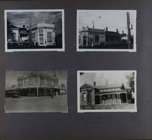 Glen Eira Historical Society
Album - Album page, Kambrook Road, Circa 1972
... North Essendon, generally acknowledged to be one of Australia's earliest houses to fully exploit this emerging style. The ornamental timberwork is especially expressive of the new architectural fashion and compares with the house at 33 Clarence Street, Elsternwick (1888-89). trevor hart kambrook road victorian style caulfield north parapets wybar's buildings 1887 caulfield bakery 1887 architectural features painted bricks balaclava road george wybrow shops milk bars airdrie polychrome bricks verandahs queen anne architectural style houses glencoe robert mair Handwritten: 196 KAMBROOK ROAD / 1970 - GAFFNEY MRS S.M. ...This page of photographs is part of the Caulfield Historical Album 1972. This album was created in approximately 1972 as part of a project by the Caulfield Historical Society to assist in identifying buildings worthy of preservation. The album is related to a Survey the Caulfield Historical Society developed in collaboration with the National Trust of Australia (Victoria) and Caulfield City Council to identify historic buildings within the City of Caulfield that warranted the protection of a National Trust Classification. Principal photographer thought to be Trevor Hart, member of Caulfield Historical Society. Most photographs were taken between 1966-1972 with a small number of photographs being older and from unknown sources. All photographs are black and white except where stated, with 386 photographs over 198 pages. First 2 images: milkbar and residence corner Kambrook and Balaclava Roads ie south west corner - building named Airdrie 3rd image: https://vhd.heritagecouncil.vic.gov.au/places/43737 - re 26 Kambrook Road and 345 Balaclava Road corner building ie south east corner: A prominently situated two-storeyed complex of late Victorian buildings consisting of "Wybar's Buildings" occupying the Balaclava Road/ Kambrook Road corner and the "Caulfield Bakery" facing Kambrook Road, separated by a driveway from a single storeyed shop. The main building has a comer splay and balustraded parapet with curved pediments, the words "Wybar's Buildings 1887" having been obliterated but "Caulfield Bakery 1887" with the characteristic wheatsheaf surviving in raised cement work. The walls are stuccoed and richly ornamented with bracketed cornices and keystones with masks extending to the Bakery. The main building is further distinguished by the Masonic symbol of the mason's dividers in the pediment whilst the upper level of the bakery is in overpainted brickwork. The single storeyed shop incorporates the bracketed cornice and consoles characteristic of the main buildings and is in other respects a utilitarian structure. 4th image: https://vhd.heritagecouncil.vic.gov.au/places/42415 (on 24/01/2021) - 196 Kambrook Road An imposing late Victorian poly-chrome brick asymmetrical villa with corner verandah and projecting west facing wing with faceted window bay to the facade. Body bricks are red and relieved by cream and black brick banding and by cream bricks to the bracketed eaves. The fretted barge with king post treatment and timber posted verandah are unique in the Municipality and unusual in the metropolitan area and demonstrate an understated appreciation of the emerging Queen Anne mode.345 Balaclava and 26 Kambrook Roads HO91 - City of Glen Eira https://vhd.heritagecouncil.vic.gov.au/places/43737 (on 24/01/2021) "Wybar's Buildings" at the corner of Balaclava Road and Kambrook Road are important as a prominent late Victorian commercial development incorporating a variety of activities including a bakery and possibly a coffee palace, the latter understood to be unique within the municipality, but characteristic of the period. It is a rare complex of its type in Caulfield and is important also as evocative evidence of the late Victorian Land Boom and the creation of a small now defunct commercial centre at this location by the George Wybrow. 196 Kambrook Road HO122 - City of Glen Eira https://vhd.heritagecouncil.vic.gov.au/places/42415 "Glencoe" is situated at no. 196 Kambrook Road, Caulfield North and was built for the boot manufacturer, Robert Bruce Mair, in 1888. It is of historic and aesthetic significance. It is historically significant (Criterion A) as the home of an inner suburban industrialist, notable a boot manufacturer, demonstrating the attraction of Caulfield as a residential location for the manufacturers of the metropolis during the late Victorian Boom period. It is aesthetically significant (Criterion E) as a very early example of a Queen Anne influenced late Victorian villa, comparing at the State level with ''Woodlands'' (1888), North Essendon, generally acknowledged to be one of Australia's earliest houses to fully exploit this emerging style. The ornamental timberwork is especially expressive of the new architectural fashion and compares with the house at 33 Clarence Street, Elsternwick (1888-89).Page 105 of Photograph Album with two photographs of a milk bar and attached residence, one older photograph of Wybar's Building and another photograph of a house on Kambrook Road (all are landscape).Handwritten: 196 KAMBROOK ROAD / 1970 - GAFFNEY MRS S.M. [under bottom right photo] / 100 [bottom left]trevor hart, kambrook road, victorian style, caulfield north, parapets, wybar's buildings 1887, caulfield bakery 1887, architectural features, painted bricks, balaclava road, george wybrow, shops, milk bars, airdrie, polychrome bricks, verandahs, queen anne architectural style, houses, glencoe, robert mair -
 Glen Eira Historical Society
Album - Album page, Bureel (Kooyong Road), Circa 1972
... building and its associations with two notable citizens. Classified:11/08/1990 trevor hart caulfield caulfield north kooyong road thomas king mansion 1860's bureel burreel francis john sidney stephen city of melbourne shire president 1850's verandah nursing home john allee ornamented corner stones new orleans manner plaster rendered mrs luxton vincent willis alexander family victorian architectural style ornate cast iron work lawyers brick houses richard buxton richard buckhurst buxton george allen george leavis allan allans music daniel luxton john taverner mary neate buxtons estate land subdivision mary neat gardens Handwritten: Bureel [top left] / 113 [bottom left] Page 113 of photograph album with 1 photograph of Burreel in its garden. ...This photograph is part of the Caulfield Historical Album 1972. This album was created in approximately 1972 as part of a project by the Caulfield Historical Society to assist in identifying buildings worthy of preservation. The album is related to a Survey the Caulfield Historical Society developed in collaboration with the National Trust of Australia (Victoria) and Caulfield City Council to identify historic buildings within the City of Caulfield that warranted the protection of a National Trust Classification. Principal photographer thought to be Trevor Hart, member of Caulfield Historical Society. Most photographs were taken between 1966-1972 with a small number of photographs being older and from unknown sources. All photographs are black and white except where stated, with 386 photographs over 198 pages. From: Glen Eira Heritage Management Plan 1996 by Andrew Ward In 1856, John Allee, a builder from Brighton, purchased C.A. 37 on the south-west corner of Glenhuntly and Kooyong Roads. The land comprised just over 45 acres. By 1863, Francis John Sidney Stephen, a lawyer and cousin of J. Wilberforce Stephen, owned most of lot 37. By 1866, Stephen had a built a "small mansion" named ''Burreel". It was a brick house and Stephen lived there until 1882. By 1884, Mrs Buxton of Hillside Terrace, East Melbourne, had purchased the property. Richard Buxton, a gentleman was listed as occupant and the house described as "brick, eight rooms". NAV was £300. Richard Buxton continued residency in 1887 however in 1888, George Allen, music seller, became occupant. At that time the house had thirteen rooms on twenty-three acres of land. Twelve people lived there and NAV was £920. In 1900, Daniel Luxton, stock and sharebroker and the Honourable John Taverner, M.H.A. leased the property. Fourteen people lived there. Mrs Buxton continued as owner. By 1910, ownership had passed to Mrs Mary Neate, who converted the house to a nursing home. The land had been subdivided by 1913 and sold by ''Buxtons Estate". Burreel Avenue, Baxter, Buxton and Hoddle Streets were created. "Burreel" was rated to Burreel Avenue and stood on lot 13 with frontages to Burreel Avenue and Kooyong Road of 198' and 214'. The house had ten rooms. NAV was £60. Mary Neate, a nurse, continued as owner/ operator of ''Burreel" nursing home in 1927. At that time there were sixteen rooms and fourteen residents. NAV was £100. Mrs Neat remained there until 1947. In 1948, the house was turned into apartments. In the 1980's, the Alexander family purchased it and restored it to a private residence.Burreel 331 Kooyong Road, ELSTERNWICK VIC 3185 - Property No B4950 National Trust https://vhd.heritagecouncil.vic.gov.au/places/65648 This is a large and substantially intact example of the grand villas of nineteenth century Melbourne. The bulk of the house most probably was built in 1866-1868 for Francis John Sidney Stephen, a prominent and highly regarded Melbourne solicitor and a member of an illustrious legal family. Stephen conducted a lucrative private practice and in 1845 was appointed first solicitor to the City of Melbourne; a position he held until his death in 1895. He took an active part in the development of Caulfield and was Shire President in 1874 and 1877. He was a resident at Burreel from 1868 to 1882. The house has evolved in stages, the rear wings possibly remaining from a house built during the 1850s. The existing ornate cast iron verandah was probably built between 1882 and 1888 during the residence of Richard Buckhurst Buxted, a notable boom period auctioneer and real estate agent. George Allan, the founder of Allan's music store, was another important occupier from 1888 to 1991. Bureel's essentially residential quality has been retained and the interior has been well preserved. The significance of this building does not rest in any single unusual outstanding architectural feature, or in its association with a particularly prominent member of society in the past, but rather in the consistent integrity of both the interior and exterior, which results in the survival of an outstanding example of this type of residential building and its associations with two notable citizens. Classified:11/08/1990Page 113 of photograph album with 1 photograph of Burreel in its garden.Handwritten: Bureel [top left] / 113 [bottom left]trevor hart, caulfield, caulfield north, kooyong road, thomas king, mansion, 1860's, bureel, burreel, francis john sidney stephen, city of melbourne, shire president, 1850's, verandah, nursing home, john allee, ornamented corner stones, new orleans manner, plaster rendered, mrs luxton, vincent willis, alexander family, victorian architectural style, ornate cast iron work, lawyers, brick houses, richard buxton, richard buckhurst buxton, george allen, george leavis allan, allans music, daniel luxton, john taverner, mary neate, buxtons estate, land subdivision, mary neat, gardens -
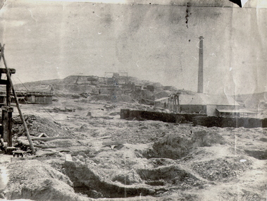 Bendigo Historical Society Inc.
Photograph - NEW CHUM HILL?
... buildings on right. Mine shaft holes in foreground. Whims centre back. Hand written on back 'Gold Mines Bendigo. Probably New Chum Hill. Looking North...new chum Batchelder Black and white photograph of mine site. Mullock heap in background with various mine buildings. Chimney stack and corrugated iron buildings on right. Mine shaft holes in foreground. Whims centre back. Hand written on back 'Gold Mines Bendigo. Probably New Chum Hill. Looking North ...Black and white photograph of mine site. Mullock heap in background with various mine buildings. Chimney stack and corrugated iron buildings on right. Mine shaft holes in foreground. Whims centre back. Hand written on back 'Gold Mines Bendigo. Probably New Chum Hill. Looking North. Phoenix, later Old Chum Mine at summit. JB Lazarus' claims in foreground. RT. 'Johnsons No. 2' on back - Royal Historical Society of Victoria, Bendigo Branch. Circular stamp. History: Prev. ACC. No. MNG 2Batchelderplace, mining site, new chum -
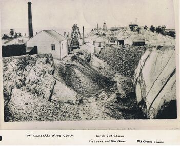 Bendigo Historical Society Inc.
Photograph - LANSELL'S 180 CLAIM, approx. 1875
... building at left with wood pile and brick chimney. 3 poppet heads in middle distance. 1 poppet head on horizon. Total of 4 chimneys visible. Im inage on original photo ' …. Reef near Ironbark Hill' In margin at bottom ' Mr. Lansell's No. 180 claim/North Old Chum/Victoria and New...New Chum or Victoria Reef' Black and white photograph of original. Large excavation in foreground. Weatherboard building at left with wood pile and brick chimney. 3 poppet heads in middle distance. 1 poppet head on horizon. Total of 4 chimneys visible. Im inage on original photo ' …. Reef near Ironbark Hill' In margin at bottom ' Mr. Lansell's No. 180 claim/North ...Black and white photograph of original. Large excavation in foreground. Weatherboard building at left with wood pile and brick chimney. 3 poppet heads in middle distance. 1 poppet head on horizon. Total of 4 chimneys visible. Im inage on original photo ' …. Reef near Ironbark Hill' In margin at bottom ' Mr. Lansell's No. 180 claim/North Old Chum/Victoria and New Chum/Old Chum Claim'Original photo by N.J. Caire, 1875, looking south New Chum or Victoria Reef'organization, business, lansell's 180 claim -
 The Beechworth Burke Museum
Photograph - Lantern Slide, c1900
... The new premises were built in 1875 utilising the skills of architect Henry Bastow though the original design may be attributable to the firm Wharton and Vickers. The design was used with modifications for other schools in Victoria, including the Competition School in Errol Street, North Melbourne. The school moved to the building...The new premises were built in 1875 utilising the skills of architect Henry Bastow though the original design may be attributable to the firm Wharton and Vickers. The design was used with modifications for other schools in Victoria, including the Competition School in Errol Street, North Melbourne. The school moved to the building ...This picture shows an angle of Beechworth Primary School (State School number 1560) which is also pictured in the building's entry in the Victorian Heritage Register (VHR record 1718). The school began as a national school in 1858 as an alternative to Wesleyan and Anglican schools already operating in the area. Its name was changed to Common School number 36 in 1862 and the Beechworth Academy prior to being taken over by the Education department in 1873. The new premises were built in 1875 utilising the skills of architect Henry Bastow though the original design may be attributable to the firm Wharton and Vickers. The design was used with modifications for other schools in Victoria, including the Competition School in Errol Street, North Melbourne. The school moved to the building pictured from its original premises in Loch Street, designed by Thomas Dalziel, which later became the office of the Ovens Advertiser. The school was opened on 2 July 1875 by former Beechworth resident G.B. Kerferd, who was then the Premier of Victoria. The image shows approximately ninety older students at the school in approximately 1900. There are approximately equal numbers of boys and girls pictured, with most of the individuals pictured appearing to be between the ages of twelve and fifteen. Although the school had more than 1000 students enrolled at its height, enrolments had declined to 304 in 1890. Also visible is a fringe of sequoia pines which were planted by the school children as a project lasting through to the late 1930s. Lantern slides, sometimes called 'magic lantern' slides, are glass plates on which an image has been secured for the purpose of projection. Glass slides were etched or hand-painted for this purpose from the Eighteenth Century but the process became more popular and accessible to the public with the development of photographic-emulsion slides used with a 'Magic Lantern' device in the mid-Nineteenth Century. Photographic lantern slides comprise a double-negative emulsion layer (forming a positive image) between thin glass plates that are bound together. A number of processes existed to form and bind the emulsion layer to the base plate, including the albumen, wet plate collodion, gelatine dry plate and woodburytype techniques. Lantern slides and magic lantern technologies are seen as foundational precursors to the development of modern photography and film-making techniques.The image is significant because it sheds light on the educational infrastructure present in Beechworth in the early part of the Twentieth Century, including the prevalence of education for students after current-day primary-school age and the education of girls. It also provides insight into the building and design practices used by Government departments at the time. Thin translucent sheet of glass with a circular image printed on the front and framed in a black backing. It is held together by metals strips to secure the edges of the slide.Obverse: L / burke museum, beechworth, lantern slide, slide, glass slide, plate, burke museum collection, photograph, monochrome, schools, education, high school, primary school, common school, state school, state school 1560, common school 36, beechworth academy, g.b. kerferd, thomas dalziel, henry bastow, victorian heritage register, beechworth primary school, girls education, boys education, public schools, education department, pines, trees, sequoias, competition school