Showing 24 items matching "occurrence records"
-
 Broadmeadows Historical Society & Museum
Document - RECORD BOOK, POLICE ACTIVITY RECORD BOOK BROADMEADOWS POLICE STATION 1927 - 1956
... ...Occurrence Records...Pages are divided into 19 columns, used to record, by Police Officers, occurrences in an area of note. ...On spine: Occurrence Record Book...Police Broadmeadows Occurrence Records 1927 1956 On spine: Occurrence Record Book Book, with blue cover and brown leather spine. ...Contains the record of police activity from 1927 to 1956.This is ultimately a record of the chances within Broadmeadows through thirty years of the twentieth century.Book, with blue cover and brown leather spine. Pages are divided into 19 columns, used to record, by Police Officers, occurrences in an area of note. Week to a page.On spine: Occurrence Record Bookpolice, broadmeadows, occurrence records, 1927, 1956 -
 4th/19th Prince of Wales's Light Horse Regiment Unit History Room
Service Record, Sherwood, Alfred Samuel Regt. No. 1648, copy of document first dated 16-7-15
... Service record of occurrences for Alf Sherwood 1915-1919 1st AIF...4th/19th Prince of Wales's Light Horse Regiment Unit History Room 4/19 PWLH Regiment, Building 78 Simpson Barracks Macleod melbourne Service record of occurrences for Alf Sherwood 1915-1919 1st AIF Alf Sherwood was a soldier of teh 4th Light Horse Regt. serving in the 1st AIF in the First world War. service file ww1 light horse service Records, National Archives of Australia Series B2455, Barcode 8083034, 21 pages Document Loose Leaf Sherwood, Alfred Samuel Regt. ...Service record of occurrences for Alf Sherwood 1915-1919 1st AIFAlf Sherwood was a soldier of teh 4th Light Horse Regt. serving in the 1st AIF in the First world War. Document Loose Leafservice Records, National Archives of Australia Series B2455, Barcode 8083034, 21 pagesservice file ww1 light horse -
 Ballan Shire Historical Society
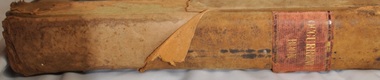
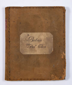
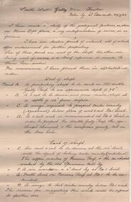
Book - Ballan Police Station - Occurrence Book, Ballan Police Station, 1860 - 1864
... Ballan Shire Historical Society 45-47 Steiglitz St Ballan goldfields Ballan - Police Station Police daily records Ballan Police Station A large journal with hard covers of soft suede leather, brown, with very faded scrolled borders. The internal pages are one week to an opening, marked Diary of Duties and Occurrences at the Ballan Police Station, with the left page for Police Duty and the right page for Horses. ...A large journal with hard covers of soft suede leather, brown, with very faded scrolled borders. The internal pages are one week to an opening, marked Diary of Duties and Occurrences at the Ballan Police Station, with the left page for Police Duty and the right page for Horses. The pages are ruled into columns with various headings.Ballan Police Stationballan - police station, police daily records -
Bendigo Historical Society Inc.
Document - The Reynolds Family Records Collection (Folder 3 of 4) Newsletter, 1989
... He left Denmark in the year 1861, embarking at Hamburg in a small sailing Ship. bendigo sandhurst peter jorgensen eleanor hinde eleanor reynolds eleanor opie reynolds collection publick occurrences The four folders contain family history documents and photos of the descendants of Eleanor Hinde. This item contains the following documents: Mandurang Newsletter "Publick Occurences", two pages, February 1989 Document The Reynolds Family Records Collection (Folder 3 of 4) Newsletter ...Eleanor Hinde (1842-1902) was born in Lancashire England. In 1858, Eleanor married Richard Reynold in the Forest St Wesleyn Methodist Church in Sandhurst. They both gave their address as Sailors Gully Goldfields. They had seven children together. Richard was a skilled tradesman and after he died in 1872 from lung disease, Eleanor married Arculus Opie. Eleanor owned a property on the corner of Gladstone and Stanley Streets which later became an electrical substation. She sold poultry and eggs and preserves. One of Eleanor's sons, William John, married Anna (Annie) Jorgensen, and one of her daughters. Amelia, married Anna's brother Thomas Joynes Jorgensen. The Jorgensens founded and managed Jorgensen and Sons foundry and engineering works. Peter Jorgensen (1849-1914), was a mining contractor, he lived at, "Bro," Russell street, Quarry Hill. His firm was Jorgensen and Sons, mining contractors. He was a native of the Island of Alsen, Denmark. He left Denmark in the year 1861, embarking at Hamburg in a small sailing Ship. The four folders contain family history documents and photos of the descendants of Eleanor Hinde. This item contains the following documents: Mandurang Newsletter "Publick Occurences", two pages, February 1989bendigo, sandhurst, peter jorgensen, eleanor hinde, eleanor reynolds, eleanor opie, reynolds collection, publick occurrences -
 Bendigo Historical Society Inc.
Administrative record - South Wattle Gully Mine Chewton, W. Edwards, May 1934
... occurrences. Report is part of the Margaret Roberts Mining Collection. Administrative record South Wattle Gully Mine Chewton W. ...Three page handwritten report. On top of first page: ' South Wattle Gully Mine, Chewton, notes by W. Edwards 20/7/65'. Edwards has 'made a study of the geological features, as shown on Mines Dept. plans' and his interpretation of same is discussed in the following areas: west of shaft; east of shaft and lode and gold occurrences. Report is part of the Margaret Roberts Mining Collection. bendigo, margaret roberts, goldmining, south wattle gully gold mine, w. edwards -
 Orbost & District Historical Society
albums
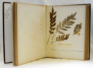
... These items are significant as a record of the occurrence of a plant species at a particular place and time and are a useful research resource. ...Annie Cameron was the daughter of John and Elizabeth Cameron. Her father was a keen geologist and botanist. Robert Pullar Cameron was a Shire Councillor for many years. He married Penuel Hossack and had a family of James, Flora, Penuel and Alex. He was listed as a significant plant collector at Orbost, Victoria who collected on the Bemm, Cann and Snowy Rivers. (Based on the list published by J.H. Willis, D. Pearson, M.T. Davis, and J.W. Green, Western Australian Herbarium Research Notes Number 12, August 1986. Enhanced with information from George, A.S. (2009) Australian Botanist's Companion, Four Gables Press, WA.)These items are significant as a record of the occurrence of a plant species at a particular place and time and are a useful research resource. They are associated with the Cameron family, early Orbost settlers. Two albums of pressed flowers. 765.1 has a red cover with gold trim and printing. 765.2 has a blue cover. 765.1 - "Collected at Cann River 1874-98 by Annie Cameron " 765.2 - "Collected we believe by Robert P. Cameron in 1890's"botany australian-plants-flowers cameron-robert-pullar cameron-annie -
 Orbost & District Historical Society
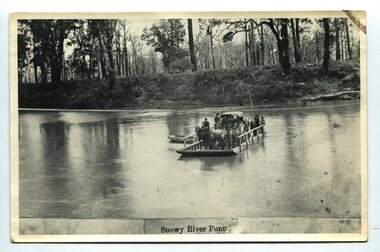
black and white photograph, late 19th century
... occurrence, the worst inundations being in 1870, 1893, 1925, 1934, 1952 and 1971. Over the years major flood protection works have been implemented. The Princes Highway, which passes Orbost, now crosses the flood plain on raised concrete supports. (info, from Victorian Places Orbost) This item is associated with the Snowy River and its history. It is a pictorial record ...A punt crossed the Snowy River at Orbost from 1884. A bridge was constructed in 1893, but was soon damaged by a huge flood. Flooding was a regular occurrence, the worst inundations being in 1870, 1893, 1925, 1934, 1952 and 1971. Over the years major flood protection works have been implemented. The Princes Highway, which passes Orbost, now crosses the flood plain on raised concrete supports. (info, from Victorian Places Orbost)This item is associated with the Snowy River and its history. It is a pictorial record of transport in the late 19th century.A black / white photograph (copy) of a punt loaded with people and a horse-drawn carriage making its way across a river.on front at bottom - "Snowy River Punt"snowy-river-orbost transport shipping -
Clunes Museum
document
... Occurrence and Extraction by Alfred G. Lock F.R.G.S published by E. & F. N. Spon 16 Charing Cross London 1882) .5 PLAN OF GOLD MINING CO'S. CLUNES (Extract taken from Dicker's Mining Record...Occurrence and Extraction by Alfred G. Lock F.R.G.S published by E. & F. N. Spon 16 Charing Cross London 1882) .5 PLAN OF GOLD MINING CO'S. CLUNES (Extract taken from Dicker's Mining Record ...INFORMATION ABOUT A STAMP SHOE FROM A CORNISH STYLE SQUARE-HEAD STAMP BATTERY POSSIBLY USED BY PORT PHILLIP MINE, CLUNES, FROM MATTHEW CHURCHWARD, SENIOR CURATOR, ENGINEERING & TRANSPORT, MUSEUM OF VICTORIA LETTER DATED 15 OCTOBER, 1997. THE GOLDFIELDS AND MINERAL DISTRICTS OF VICTORIA. GOLD ITS OCCURRENCE AND EXTRACTION, PLAN OF GOLD MINING COMPANIESINFORMATION RECEIVED REGARDING THE PORT PHILLIP MINE; Including .1 COPY OF ARTICLE 12TH MAY, 1858 FROM "THE ARGUS." MELBOURNE. .2 LETTER FROM "SCIENCEWORKS" TO MR. ALAN KEEBLE DATED 15/10/1997 (3 Pages) .3 SECTION OF MERCURY, TROUGHS, STAKES & STAMPS (Extract taken from publication, The Gold Fields, Mineral Districts of Victoria, by R. Brough Smyth F.G.S, published by Queensberry Hill Press 1979) .4 GOLD. ITS OCCURRENCE AND EXTRACTION (Extract taken from publication, Gold: Its Occurrence and Extraction by Alfred G. Lock F.R.G.S published by E. & F. N. Spon 16 Charing Cross London 1882) .5 PLAN OF GOLD MINING CO'S. CLUNES (Extract taken from Dicker's Mining Record 26/3/1867, page 173. https://trove.nla.gov.au/work/32734386?q&versionId=39944948) local history, mining, company exploration -
Dandenong/Cranbourne RSL Sub Branch
RAAF Papers -Flight Sargent Clarence John Lovell
... 1/Service ID Card- 2/Guide to wearing of Stars, Defence Medals & War Medals on Civilian Clothing-3/Picture of Lancaster Bomber-4/Letter of Appreciation To CJ Lovell-5/Responsibilities of prisoner of war publication- 6/Letter from 467_463 Lancaster Bomber Squadrons Association regarding search of Operations and record Book for F/Sgt Lovell -7/Personal Occurrence report RAAF Airmen 467 Squadron- ...Dandenong/Cranbourne RSL Sub Branch 44 – 50 Clow Street Dandenong melbourne 1/Service ID Card- 2/Guide to wearing of Stars, Defence Medals & War Medals on Civilian Clothing-3/Picture of Lancaster Bomber-4/Letter of Appreciation To CJ Lovell-5/Responsibilities of prisoner of war publication- 6/Letter from 467_463 Lancaster Bomber Squadrons Association regarding search of Operations and record Book for F/Sgt Lovell -7/Personal Occurrence report RAAF Airmen 467 Squadron- RAAF Papers -Flight Sargent Clarence John Lovell ...1/Service ID Card- 2/Guide to wearing of Stars, Defence Medals & War Medals on Civilian Clothing-3/Picture of Lancaster Bomber-4/Letter of Appreciation To CJ Lovell-5/Responsibilities of prisoner of war publication- 6/Letter from 467_463 Lancaster Bomber Squadrons Association regarding search of Operations and record Book for F/Sgt Lovell -7/Personal Occurrence report RAAF Airmen 467 Squadron- -
 Kew Historical Society Inc
Biographical information, Ronald Horace Setford (1915–1988)
... occurrence. Ron made his own title slides, interval slides and end slides. As well as many holiday photos (around Australia and their world trip in 1966), he enjoyed photographing local landmarks, flowers, insects and family. One of Ron’s photography projects was to record...occurrence. Ron made his own title slides, interval slides and end slides. As well as many holiday photos (around Australia and their world trip in 1966), he enjoyed photographing local landmarks, flowers, insects and family. One of Ron’s photography projects was to record ...Ronald Horace Setford was born in April 1915 at 18 Church Street, Hawthorn, at his family’s home above their decorator shop. He was the second of three sons born to Horace Turner Setford (1880-1944) and Mabel Crofts (1887-1943). He attended Hawthorn West Primary School and then Swinburne before beginning work in his family’s business ‘Setford and Son’ in October 1930. This was formalised in April 1931 when he became a carpentry and joinery apprentice. In 1934 he graduated as a grade four carpenter. Ron worked in the family business until 1964 and then worked at J S Kidd and Co Pty Ltd as a storeman until his retirement in December 1973. Ron married Grace Muriel Agnes Perrey (1915-2001) in 1936 and they first lived in Kew around 1940, at 38 Marshall Avenue. Ron served in the Citizen Military Forces as a sapper with the 9 Australian Army Transport Company, Royal Australian Engineers, signing up a week after Darwin had been bombed. He spent time in Darwin, Wayville (South Australia), Herberton and Grovely (Queensland). Afterwards he refused to eat rice, never spoke of the war, nor took part in any ANZAC day proceedings. In 1941, Ron and Grace bought their block of land at 9 Tanner Avenue, East Kew, part of the Old Golf Links Estate, for £225. It was not until December 1945 that Ron started building their home and they moved in during May 1947. Ron and Grace remained there for thirty-seven years until the house was sold to their nephew in 1984. It has since been demolished. Ron’s great passion was photography and in the early 1960s he purchased his Minolta camera. Slide evenings at Tanner Avenue were a regular occurrence. Ron made his own title slides, interval slides and end slides. As well as many holiday photos (around Australia and their world trip in 1966), he enjoyed photographing local landmarks, flowers, insects and family. One of Ron’s photography projects was to record the progress of the building of the Eastern Freeway. This was near their home, and he’d walk down to the works on a regular basis, dressed smartly, with his camera in hand. The workers thought he was an official photographer, and he was allowed on site to take his photos. In 1984, Ron and Grace downsized and moved to Bayswater. Ron passed away on 31 October 1988 at the Maroondah Hospital in Ringwood East, at age 73. His ashes were spread on his beloved rose bushes at Tanner Avenue. Lauren Thomson, 2025ron setford, 9 tanner avenue -- kew east (vic, setford and son -- 18 church st (hawthorn), grace muriel agnes perrey, 9 australian army transport company, j s kidd and co pty ltd, eastern freeway, f19 freeway -
 Kew Historical Society Inc
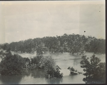
Photograph - Yarra in Flood from Willsmere, North Kew, 1923
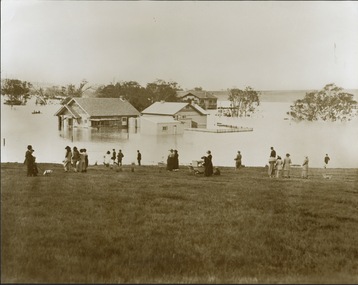
... occurrence. Extreme flood events of the Yarra River are recorded to have occurred in 1891, 1901, 1916, 1923 and 1934. ...occurrence. Extreme flood events of the Yarra River are recorded to have occurred in 1891, 1901, 1916, 1923 and 1934. ...Flooding of the Yarra Valley, including that section of the Yarra bordering Kew and Kew East in the north and west of the municipality, was a regular occurrence. Extreme flood events of the Yarra River are recorded to have occurred in 1891, 1901, 1916, 1923 and 1934. The Municipality of Kew's response to these floods was to enact planning decisions restricting residential development in flood prone areas following the floods of 1916, 1921, and 1934. While floods continued after the development of the Upper Yarra Reservoir (construction 1948-57), the regularity and extent of these inundations diminished. Original, large sepia photograph showing men, women and children who have gathered on a grassy verge, probably farm land, to look out across the flooded Yarra Valley at Willsmere, North Kew. In the medium distance are three houses that are largely submerged by the flood waters as well as a number of Eucalypts. Inscribed reverse: "Gift of Kerrie Woollard (KCC) (P)C.1923yarra river valley, kew east (vic.), floods, willsmere -
 Kew Historical Society Inc
Photograph - Flood at Fairfield Park, 1934
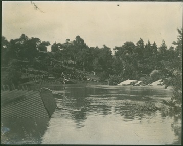
... occurrence. Extreme flood events of the Yarra River are recorded to have occurred in 1891, 1901, 1916, 1923 and 1934. ...occurrence. Extreme flood events of the Yarra River are recorded to have occurred in 1891, 1901, 1916, 1923 and 1934. ...Flooding of the Yarra Valley, including that section of the Yarra bordering Kew and Kew East in the north and west of the municipality, was a regular occurrence. Extreme flood events of the Yarra River are recorded to have occurred in 1891, 1901, 1916, 1923 and 1934. The Municipality of Kew's response to these floods was to enact planning decisions restricting residential development in flood prone areas following the floods of 1916, 1921 and 1934. While floods continued after the development of the Upper Yarra Reservoir (construction 1948-57), the regularity and extent of these inundations diminished.Black and white print positive. Yarra River at Fairfield in 1934. Major flood resulting in submerged buildings in middle ground and onlookers on far bankReverse: "Flood of Yarra at Fairfield Park 1934"fairfield park, yarra valley, river yarra, floods -- 1934 -
 Kew Historical Society Inc
Photograph - Yarra in Flood, 1934
... occurrence. Extreme flood events of the Yarra River are recorded to have occurred in 1891, 1901, 1916, 1923 and 1934. ...occurrence. Extreme flood events of the Yarra River are recorded to have occurred in 1891, 1901, 1916, 1923 and 1934. ...Flooding of the Yarra Valley, including that section of the Yarra bordering Kew and Kew East in the north and west of the municipality, was a regular occurrence. Extreme flood events of the Yarra River are recorded to have occurred in 1891, 1901, 1916, 1923 and 1934. The Municipality of Kew's response to these floods was to enact planning decisions restricting residential development in flood prone areas following the floods of 1916, 1921 and 1934. While floods continued after the development of the Upper Yarra Reservoir (construction 1948-57), the regularity and extent of these inundations diminished.Black and white print positive. 1934 floods of the Yarra Valley. Location Fairfield looking towards wooded hillside. Houses floating in river.Reverse: "From Fairfield Park (11936?) back towards hill (Wurundjeri Spur?)"floods -- 1934, yarra valley, yarra river, fairfield park -
 Kew Historical Society Inc
Photograph - River Yarra in Flood from Kilby Road
... occurrence. Extreme flood events of the Yarra River are recorded to have occurred in 1891, 1901, 1916, 1923 and 1934. ...occurrence. Extreme flood events of the Yarra River are recorded to have occurred in 1891, 1901, 1916, 1923 and 1934. ...Flooding of the Yarra Valley, including that section of the Yarra bordering Kew and Kew East in the north and west of the municipality, was a regular occurrence. Extreme flood events of the Yarra River are recorded to have occurred in 1891, 1901, 1916, 1923 and 1934. The Municipality of Kew's response to these floods was to enact planning decisions restricting residential development in flood prone areas following the floods of 1916, 1921 and 1934. While floods continued after the development of the Upper Yarra Reservoir (construction 1948-57), the regularity and extent of these inundations diminished.Print copy of an original photo of the River Yarra in Flood, taken from Kilby Road.VIEW ACROSS YARRA IN FLOOD / FROM KILBY RD KEWkilby road, floods -- kew (vic.), kilby farm -
Kew Historical Society Inc
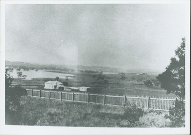
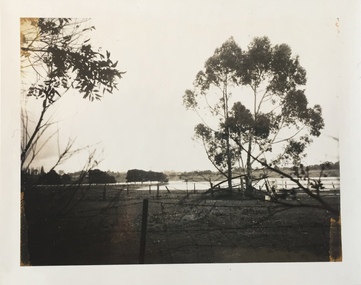
Collection, Floods in North Kew (Series), 1929–1934
... occurrence. Extreme flood events of the Yarra River are recorded to have occurred in 1891, 1901, 1916, 1923 and 1934. ...occurrence. Extreme flood events of the Yarra River are recorded to have occurred in 1891, 1901, 1916, 1923 and 1934. ...Flooding of the Yarra Valley, including that section of the Yarra bordering Kew and Kew East in the north and west of the municipality, was a regular occurrence. Extreme flood events of the Yarra River are recorded to have occurred in 1891, 1901, 1916, 1923 and 1934. The Municipality of Kew's response to these floods was to enact planning decisions restricting residential development in flood prone areas following the floods of 1916, 1921 and 1934. While floods continued after the development of the Upper Yarra Reservoir (construction 1948-57), the regularity and extent of these inundations diminished. Natural disasters had an impact on the development and settlement of Melbourne and its suburbs. Flooding in the Melbourne region was a regular event in the nineteenth and for most of the twentieth centuries. Changes in the impact of natural disasters could occur due to a number of factors. This collection of small snapshots, mostly taken from Kellett Grove in North Kew, provide provenanced evidence of flooding in the area before the development of the unnatural flood barrier that is the Eastern Freeway.Collection of 16 monochrome photographs, annotated on verso by different hands, of the flooding of the River Yarra in North Kew in the third and fourth decades of the twentieth century [1920s & 1930s]. Individual photos include the dates of different floods. Many of the photos were taken from the rear of 8 Kellett Grove; a house still extant in 2023yarra river -- north kew, floods -- yarra valley, floods -- north kew, floods -- 1929, floods -- 1934, natural disasters -- kew -
 Kew Historical Society Inc
Photograph - Yarra Valley Floods: Kew East, 1916
... occurrence. Extreme flood events of the Yarra River are recorded to have occurred in 1891, 1901, 1916, 1923 and 1934. ...occurrence. Extreme flood events of the Yarra River are recorded to have occurred in 1891, 1901, 1916, 1923 and 1934. ...Flooding of the Yarra Valley, including that section of the Yarra bordering Kew and Kew East in the north and west of the municipality, was a regular occurrence. Extreme flood events of the Yarra River are recorded to have occurred in 1891, 1901, 1916, 1923 and 1934. The Municipality of Kew's response to these floods was to enact planning decisions restricting residential development in flood prone areas following the floods of 1916, 1921 and 1934. While floods continued after the development of the Upper Yarra Reservoir (construction 1948-57), the regularity and extent of these inundations diminished. During the nineteenth century, the land abutting the south side of the Yarra in Kew was devoted to dairy farming. In the twentieth century, before and after the construction of the Eastern Freeway, much of this low-lying area was used as golf courses and public parks.One of a collection of photographs of flooding in the Kew section of the Yarra Valley which are in important research resource for the location and extent of flooding in the first half of the twentieth century. Flooding of the Yarra Valley at East Kew in 1916. The view is taken from the intersection of Kilby Road with what is believed to be Birdwood Street, looking across the flood waters to Ivanhoe. The extensive flooded area shown in the photograph would have included the Kew Golf Club. Verso: "Floods along Kilby Road / near Birdwood St? & Kilby Road / 1917? / 87yarra river, yarra valley, floods -- kew, kilby road -- kew (vic.), kew golf club -
 Kew Historical Society Inc
Photograph - Yarra Valley Floods: Kew East, 1916
... occurrence. Extreme flood events of the Yarra River are recorded to have occurred in 1891, 1901, 1916, 1923 and 1934. ...occurrence. Extreme flood events of the Yarra River are recorded to have occurred in 1891, 1901, 1916, 1923 and 1934. ...Flooding of the Yarra Valley, including that section of the Yarra bordering Kew and Kew East in the north and west of the municipality, was a regular occurrence. Extreme flood events of the Yarra River are recorded to have occurred in 1891, 1901, 1916, 1923 and 1934. The Municipality of Kew's response to these floods was to enact planning decisions restricting residential development in flood prone areas following the floods of 1916, 1921 and 1934. While floods continued after the development of the Upper Yarra Reservoir (construction 1948-57), the regularity and extent of these inundations diminished. During the nineteenth century, the land abutting the south side of the Yarra in Kew was devoted to dairy farming. In the twentieth century, before and after the construction of the Eastern Freeway, much of this low-lying area was used as golf courses and public parks.One of a collection of photographs of flooding in the Kew section of the Yarra Valley which are in important research resource for the location and extent of flooding in the first half of the twentieth century. Flooding of the Yarra Valley at East Kew in 1916. The view is taken from a street (maybe Birdwood Avenue) intersecting with Kilby Road looking northeast across the flood waters to Ivanhoe and Heidelberg. The extensive flooded area shown in the photograph would have included remnant dairy farms and the Kew Golf Club. Verso: "Floods / Yarra River / East Kew / Kilby Road / 1917? / 87"yarra river, yarra valley, floods -- kew, kilby road -- kew (vic.), kew golf club -
 Kew Historical Society Inc
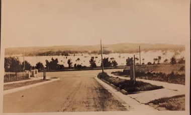
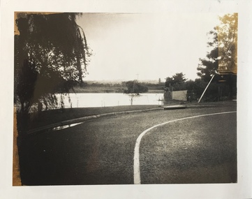
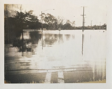
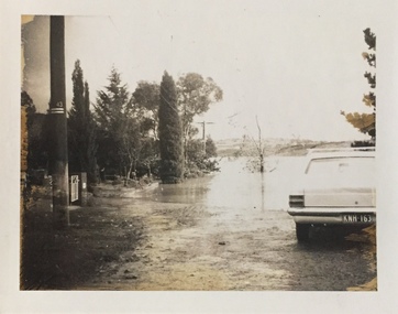
Photograph - Flooding of the Yarra Valley at Kew East, 1974
... occurrence. Extreme flood events of the Yarra River are recorded to have occurred in 1891, 1901, 1916, 1923 and 1934. ...occurrence. Extreme flood events of the Yarra River are recorded to have occurred in 1891, 1901, 1916, 1923 and 1934. ...Flooding of the Yarra Valley, including that section of the Yarra bordering Kew and Kew East in the north and west of the municipality, was a regular occurrence. Extreme flood events of the Yarra River are recorded to have occurred in 1891, 1901, 1916, 1923 and 1934. The Municipality of Kew's response to these floods was to enact planning decisions restricting residential development in flood prone areas following the floods of 1916, 1921 and 1934. While floods continued after the development of the Upper Yarra Reservoir (construction 1948-57), the regularity and extent of these inundations diminished. During the nineteenth century, the land abutting the south side of the Yarra in Kew was devoted to dairy farming. In the twentieth century, before and after the construction of the Eastern Freeway, much of this low-lying area was used as golf courses and public parks.Late example of the capacity of the Yarra Valley at Kew to flood, even though drainage works and the Upper Yarra Reservoir had reduced their regularity.Original black and white print photograph of the low-lying land at East Kew under floodwater on 16 May 1974. The vantage point of the photographer is Lister Street. In the photo, the fences of the Kilby Farm can be seen. Flooding was caused by overflowing water in Glass' Creek and the River Yarra. Annotation verso: "Hay's Paddock op No.30 Lister Street / 16 May 1974 11.50am / R.L. 46.04"hays paddock, floods, yarra river, glass' creek, lister street -
 Kew Historical Society Inc
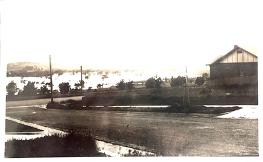
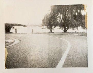
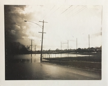
Photograph - Flooding of the Yarra Valley at Kew East, 1974
... occurrence. Extreme flood events of the Yarra River are recorded to have occurred in 1891, 1901, 1916, 1923 and 1934. ...occurrence. Extreme flood events of the Yarra River are recorded to have occurred in 1891, 1901, 1916, 1923 and 1934. ...Flooding of the Yarra Valley, including that section of the Yarra bordering Kew and Kew East in the north and west of the municipality, was a regular occurrence. Extreme flood events of the Yarra River are recorded to have occurred in 1891, 1901, 1916, 1923 and 1934. The Municipality of Kew's response to these floods was to enact planning decisions restricting residential development in flood prone areas following the floods of 1916, 1921 and 1934. While floods continued after the development of the Upper Yarra Reservoir (construction 1948-57), the regularity and extent of these inundations diminished. During the nineteenth century, the land abutting the south side of the Yarra in Kew was devoted to dairy farming. In the twentieth century, before and after the construction of the Eastern Freeway, much of this low-lying area was used as golf courses and public parks.Late example of the capacity of the Yarra Valley at Kew to flood, even though drainage works and the Upper Yarra Reservoir had reduced their regularity.Original black and white print photograph of the low-lying land at East Kew under floodwater on 16 May 1974. The vantage point of the photographer is Lister Street. Flooding was caused by overflowing water in Glass' Creek and the River Yarra. Annotation verso: "Lister Street looking north / Flood level / 16 May 1974 11.30am / R.L. 46.04"hays paddock, floods, yarra river, glass' creek, lister street -
 Kew Historical Society Inc
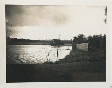
Photograph - Flooding of the Yarra Valley at Kew East, 1974
... occurrence. Extreme flood events of the Yarra River are recorded to have occurred in 1891, 1901, 1916, 1923 and 1934. ...occurrence. Extreme flood events of the Yarra River are recorded to have occurred in 1891, 1901, 1916, 1923 and 1934. ...Flooding of the Yarra Valley, including that section of the Yarra bordering Kew and Kew East in the north and west of the municipality, was a regular occurrence. Extreme flood events of the Yarra River are recorded to have occurred in 1891, 1901, 1916, 1923 and 1934. The Municipality of Kew's response to these floods was to enact planning decisions restricting residential development in flood prone areas following the floods of 1916, 1921 and 1934. While floods continued after the development of the Upper Yarra Reservoir (construction 1948-57), the regularity and extent of these inundations diminished. During the nineteenth century, the land abutting the south side of the Yarra in Kew was devoted to dairy farming. In the twentieth century, before and after the construction of the Eastern Freeway, much of this low-lying area was used as golf courses and public parks.Late example of the capacity of the Yarra Valley at Kew to flood, even though drainage works and the Upper Yarra Reservoir had reduced their regularity.Original black and white print photograph of Hay's Paddock under floodwater on 16 May 1974. The vantage point of the photographer is Keystone Crescent looking east. Flooding was caused by overflowing water in Glass' Creek and the River Yarra. Annotation verso: "Keystone Cr looking east / 16 May 1974 11.50am"hays paddock, floods, yarra river, glass' creek -
 Kew Historical Society Inc
Photograph - Flooding of the Yarra Valley at Kew East, 1974
... occurrence. Extreme flood events of the Yarra River are recorded to have occurred in 1891, 1901, 1916, 1923 and 1934. ...occurrence. Extreme flood events of the Yarra River are recorded to have occurred in 1891, 1901, 1916, 1923 and 1934. ...Flooding of the Yarra Valley, including that section of the Yarra bordering Kew and Kew East in the north and west of the municipality, was a regular occurrence. Extreme flood events of the Yarra River are recorded to have occurred in 1891, 1901, 1916, 1923 and 1934. The Municipality of Kew's response to these floods was to enact planning decisions restricting residential development in flood prone areas following the floods of 1916, 1921 and 1934. While floods continued after the development of the Upper Yarra Reservoir (construction 1948-57), the regularity and extent of these inundations diminished. During the nineteenth century, the land abutting the south side of the Yarra in Kew was devoted to dairy farming. In the twentieth century, before and after the construction of the Eastern Freeway, much of this low-lying area was used as golf courses and public parks.Late example of the capacity of the Yarra Valley at Kew to flood, even though drainage works and the Upper Yarra Reservoir had reduced their regularity.Original black and white print photograph of the low-lying land at East Kew under floodwater on 16 May 1974. The vantage point of the photographer is Lister Street. Flooding was caused by overflowing water in Glass' Creek and the River Yarra. Annotation verso: "Lister St looking same as No.3 / 16 May 1974 11.30"floods, yarra river, glass' creek, lister street -
 Kew Historical Society Inc
Photograph - Flooding of the Yarra Valley at Kew East, 1974
... occurrence. Extreme flood events of the Yarra River are recorded to have occurred in 1891, 1901, 1916, 1923 and 1934. ...occurrence. Extreme flood events of the Yarra River are recorded to have occurred in 1891, 1901, 1916, 1923 and 1934. ...Flooding of the Yarra Valley, including that section of the Yarra bordering Kew and Kew East in the north and west of the municipality, was a regular occurrence. Extreme flood events of the Yarra River are recorded to have occurred in 1891, 1901, 1916, 1923 and 1934. The Municipality of Kew's response to these floods was to enact planning decisions restricting residential development in flood prone areas following the floods of 1916, 1921 and 1934. While floods continued after the development of the Upper Yarra Reservoir (construction 1948-57), the regularity and extent of these inundations diminished. During the nineteenth century, the land abutting the south side of the Yarra in Kew was devoted to dairy farming. In the twentieth century, before and after the construction of the Eastern Freeway, much of this low-lying area was used as golf courses and public parks.Late example of the capacity of the Yarra Valley at Kew to flood, even though drainage works and the Upper Yarra Reservoir had reduced their regularity.Original black and white print photograph of the low-lying land at East Kew under floodwater on 16 May 1974. The vantage point of the photographer is at Willsmere Road. The road itself is underwater.Annotation verso: "Willsmere Rd / Same as No.7 / 16 May 1974 11.15am"floods, yarra river, willsmere road -
 Kew Historical Society Inc
Photograph - Flooding of the Yarra Valley at Kew East, 1974
... occurrence. Extreme flood events of the Yarra River are recorded to have occurred in 1891, 1901, 1916, 1923 and 1934. ...occurrence. Extreme flood events of the Yarra River are recorded to have occurred in 1891, 1901, 1916, 1923 and 1934. ...Flooding of the Yarra Valley, including that section of the Yarra bordering Kew and Kew East in the north and west of the municipality, was a regular occurrence. Extreme flood events of the Yarra River are recorded to have occurred in 1891, 1901, 1916, 1923 and 1934. The Municipality of Kew's response to these floods was to enact planning decisions restricting residential development in flood prone areas following the floods of 1916, 1921 and 1934. While floods continued after the development of the Upper Yarra Reservoir (construction 1948-57), the regularity and extent of these inundations diminished. During the nineteenth century, the land abutting the south side of the Yarra in Kew was devoted to dairy farming. In the twentieth century, before and after the construction of the Eastern Freeway, much of this low-lying area was used as golf courses and public parks.Late example of the capacity of the Yarra Valley at Kew to flood, even though drainage works and the Upper Yarra Reservoir had reduced their regularity.Original black and white print photograph of the low-lying land at East Kew under floodwater on 16 May 1974. The photograph is of Hyde Park looking north-east.Annotation verso: "Hyde Park looking nth-east / Flood Level / 16 May 1974 11.15am / R.L. 46.61"floods, yarra river, hyde park -
 Kew Historical Society Inc
Photograph - Flooding of the Yarra Valley at Kew, 1974
... occurrence. Extreme flood events of the Yarra River are recorded to have occurred in 1891, 1901, 1916, 1923 and 1934. ...occurrence. Extreme flood events of the Yarra River are recorded to have occurred in 1891, 1901, 1916, 1923 and 1934. ...Flooding of the Yarra Valley, including that section of the Yarra bordering Kew and Kew East in the north and west of the municipality, was a regular occurrence. Extreme flood events of the Yarra River are recorded to have occurred in 1891, 1901, 1916, 1923 and 1934. The Municipality of Kew's response to these floods was to enact planning decisions restricting residential development in flood prone areas following the floods of 1916, 1921 and 1934. While floods continued after the development of the Upper Yarra Reservoir (construction 1948-57), the regularity and extent of these inundations diminished. During the nineteenth century, the land abutting the south side of the Yarra in Kew was devoted to dairy farming. In the twentieth century, before and after the construction of the Eastern Freeway, much of this low-lying area was used as golf courses and public parks.Late example of the capacity of the Yarra Valley at Kew to flood, even though drainage works and the Upper Yarra Reservoir had reduced their regularity.Original black and white print photograph of the low-lying land at East Kew under floodwater on 16 May 1974. The photograph is taken from 43 Kellett Grove.Annotation verso: "Kellett Gve No.43 / Flood Level / 16 May 1974 11.40am"floods, yarra river, kellett grove