Showing 40 items matching "old bendigo cemetery"
-
 Bendigo Historical Society Inc.
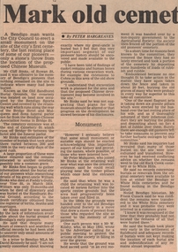
Newspaper - NEWSPAPER CLIPPINGS CALL FOR A MONUMENT TO THE PIONEERS OF THE OLD BENDIGO CEMETERY, 1987
... NEWSPAPER CLIPPINGS CALL FOR A MONUMENT TO THE PIONEERS OF THE OLD BENDIGO CEMETERY......old bendigo cemetery...Newspaper NEWSPAPER CLIPPINGS CALL FOR A MONUMENT TO THE PIONEERS OF THE OLD BENDIGO CEMETERY ...Newspaper Clipping 09 April 1987 Bendigo Advertiser Historian Mr Cliff Binks descendant of some of the original Bendigo Pioneers calls for a monument to honour and remember those who were buried in The Old Sandhurst Burial Grounds.bendigo, history, old bendigo cemetery -
 Bendigo Historical Society Inc.
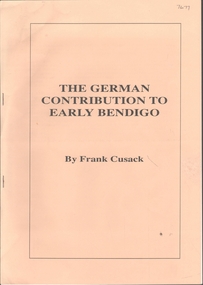
Document - FRANK CUSACK: 'THE GERMAN CONTRIBUTION TO EARLY BENDIGO'
... Jacob Brahe. Old Bendigo Cemetery....History House 11 Mackenzie Street Bendigo goldfields BENDIGO Mining early German history German Diggers Diamond Hill Mangurang Mexican enclave at Eaglehawke Irish town Back Creek Ironbark Gully White Hills Georg Bruhn Menge Jacob Brahe. Old Bendigo Cemetery. 'The German Contribution to Early Bendigo' ( 23rd Feb) 1986 lecture by Frank Cusack on the occasion of the 130th anniversary of the first Lutheran service in Bendigo). ...'The German Contribution to Early Bendigo' ( 23rd Feb) 1986 lecture by Frank Cusack on the occasion of the 130th anniversary of the first Lutheran service in Bendigo). Origins of the large flow of Germans to the goldfields (failure of liberalism at home; conscription threat). Mention of George Bruhn, Menge (opal discoverer), Jacob Brahe; Ballerstedt; Wittscheibe; Schlemm; Ernst Mueller; Morris Collman; Louis Samuels; Gustave Adolphus Hugo Thureau; Backhaus; Pastor Friedrich Leypoldt; various German vignerons; ''The Hamburg'' (hotel); ''The Berlin'' (hotel); ''The European'' (hotel); Deutsche Verein; Paul Bucholz; Herr Gollmick; Early architects - Getzschmann, Bosselmann, Nicolai, Emil Mauermann, Friedrich Lehmann; Medical people - Dr Barnett; , Dr Landvoigt. Dr Sandner Snr.; others - Conrad Meyerhoff (patent gold cradle), Benno Sluytmann (first electricity plant in Bendigo), Gustavus con Tempsky (re Burke & Wills expedition), Ludwig Becker (Burke & Wills expedition); Josef Von St. Nicolai (Freemasonry); Captain Von Paleski.bendigo, mining, early german history, german diggers, diamond hill, mangurang, mexican enclave at eaglehawke, irish town, back creek, ironbark gully, white hills, georg bruhn, menge, jacob brahe. old bendigo cemetery. -
 Bendigo Historical Society Inc.
Document - FRANK CUSACK: 'THE GERMAN CONTRIBUTION TO EARLY BENDIGO'
... Jacob Brahe. Old Bendigo Cemetery....History House 11 Mackenzie Street Bendigo goldfields BENDIGO Mining early German history German Diggers Diamond Hill Mangurang Mexican enclave at Eaglehawke Irish town Back Creek Ironbark Gully White Hills Georg Bruhn Menge Jacob Brahe. Old Bendigo Cemetery. Frank Cusack 'The German Contribution to Early Bendigo' ( 23rd Feb) 1986 lecture by Frank Cusack on the occasion of the 130th anniversary of the first Lutheran service in Bendigo). ...'The German Contribution to Early Bendigo' ( 23rd Feb) 1986 lecture by Frank Cusack on the occasion of the 130th anniversary of the first Lutheran service in Bendigo). Origins of the large flow of Germans to the goldfields (failure of liberalism at home; conscription threat). Mention of George Bruhn, Menge (opal discoverer), Jacob Brahe; Ballerstedt; Wittscheibe; Schlemm; Ernst Mueller; Morris Collman; Louis Samuels; Gustave Adolphus Hugo Thureau; Backhaus; Pastor Friedrich Leypoldt; various German vignerons; ''The Hamburg'' (hotel); ''The Berlin'' (hotel); ''The European'' (hotel); Deutsche Verein; Paul Bucholz; Herr Gollmick; Early architects - Getzschmann, Bosselmann, Nicolai, Emil Mauermann, Friedrich Lehmann; Medical people - Dr Barnett; , Dr Landvoigt. Dr Sandner Snr.; others - Conrad Meyerhoff (patent gold cradle), Benno Sluytmann (first electricity plant in Bendigo), Gustavus con Tempsky (re Burke & Wills expedition), Ludwig Becker (Burke & Wills expedition); Josef Von St. Nicolai (Freemasonry); Captain Von Paleski.Frank Cusackbendigo, mining, early german history, german diggers, diamond hill, mangurang, mexican enclave at eaglehawke, irish town, back creek, ironbark gully, white hills, georg bruhn, menge, jacob brahe. old bendigo cemetery. -
 Bendigo Historical Society Inc.
Document - FRIENDS OF WHITE HILLS CEMETERY COLLECTION: LETTER, 22 October 1993
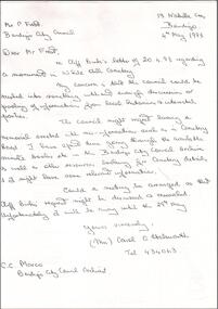
... Letter to Greta Balsillie from Peter Frost CoGB Re Proposed Monument at White Hills Cemetery recognizing the Old Bendigo Cemetery. Letter dated 22nd October 1993....Bendigo goldfields DOCUMENT Memo Letter to Greta Balsille Document. Letter to Greta Balsillie from Peter Frost CoGB Re Proposed Monument at White Hills Cemetery recognizing the Old Bendigo Cemetery. ...Document. Letter to Greta Balsillie from Peter Frost CoGB Re Proposed Monument at White Hills Cemetery recognizing the Old Bendigo Cemetery. Letter dated 22nd October 1993.document, memo, letter to greta balsille -
 Bendigo Historical Society Inc.
Document - BENDIGO CEMETERIES COLLECTION: CITY OF BENDIGO LETTERS
... Bendigo letterhead both addressed to C. Holsworth one dated 12th May, 1993 - RE proposal for a Memorial at White Hills Cemetery, the second one dated 22nd October 1993 - RE Proposed Monument Old Bendigo Cemetery. ...BENDIGO Council cemetery Two letters on City of Bendigo letterhead both addressed to C. Holsworth one dated 12th May, 1993 - RE proposal for a Memorial at White Hills Cemetery, the second one dated 22nd October 1993 - RE Proposed Monument Old Bendigo Cemetery. ...Two letters on City of Bendigo letterhead both addressed to C. Holsworth one dated 12th May, 1993 - RE proposal for a Memorial at White Hills Cemetery, the second one dated 22nd October 1993 - RE Proposed Monument Old Bendigo Cemetery. Also a photocopy of an handwritten letter from Carol Holsworth to Mr. Frost of the Bendigo City Council and one from Mr. Q. C. Binks.bendigo, council, cemetery -
 Bendigo Military Museum
Book, Corfield and company, Give me back my dear old cobbers, 2008
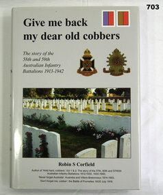
... Bendigo goldfields military history books The story pf the 58th and 59th Australian Infantry Battalions 1913-1942. Author Robin S Corfeild Black hard cover with grey dust jacket with photos- Ruc Petillon cemetery and Badges from 58th and 59th Battalions. Give me back my dear old ...The story pf the 58th and 59th Australian Infantry Battalions 1913-1942. Author Robin S Corfeild Black hard cover with grey dust jacket with photos- Ruc Petillon cemetery and Badges from 58th and 59th Battalions.military history, books -
 Bendigo Historical Society Inc.
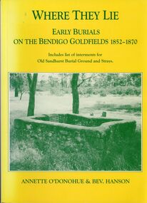
Book - WHERE THEY LIE
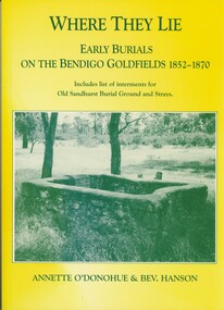
... History House 11 Mackenzie Street Bendigo goldfields CEMETERY old sandhurst burial ground. ...'Where They Lie'. Early burials on the Bendigo Goldfields 1852 - 1870. Including list of interments for Old Sandhurst Burial Ground and Strays. Limited Edition No. 157. Receipt for purchase loose inside front cover.Annette O'Donohue and Bev. Hanson.cemetery, old sandhurst burial ground. -
 Bendigo Historical Society Inc.
Document - LONG GULLY HISTORY GROUP COLLECTION: THE BENDIGO GOLDFIELD … INTRODUCTION TO FIELD
... Bendigo Amalgamated Goldfields Coy... Long Gully Post Office... The Old Wheal Owl... Central Nell Gwynne... Gold Mines Hotel... Bendigo City Council... Mr Jack Barker... Bendigo and District Tourist Association... The New Chum Syncline... Courier of the Mines newspaper... Camp Hill School... Sandhurst East Post Office... Bendigo Cemetery...History House 11 Mackenzie Street Bendigo goldfields BENDIGO History long gully history group The Long Gully History Group - The Bendigo Goldfield...Introduction to Field A Richardson New Chum Railway Mine The Dascombe Nugget The Victoria Nugget R R Haverfield Ballerstadt Rae Wittscheibe Lazarus Cave and Amos Geo Lansell The Old Chum Victoria Specimen Hustlers Bendigo Amalgamated Goldfields Bendigo Mines Limited Nell Gwynne Napoleon Carshalton The Deborah Roberts & Sons The North Deborah Williams' United Central Deborah Lansell's South Red White & Blue The New Red White and Blue Consolidated (Big Blue) Union H Harkness & Co Thompson & Co Lansell's Bendigo Battery Showgrounds Industrial Hall North Red White and Blue Central Red White and Blue Little 180 John Brown Knitwear Factory South Ironbark Victoria Consols East Shaft Ironbark Manchester Arms Hotel Unity Mine Wattle Gully Mine Chewton Hercules Hercules and Energetic Bendigo Amalgamated Goldfields Coy Long Gully Post Office The Old Wheal Owl Central Nell Gwynne Gold Mines Hotel Bendigo City Council Mr Jack Barker Bendigo and District Tourist Association The New Chum Syncline Courier of the Mines newspaper Camp Hill School Sandhurst East Post Office Bendigo Cemetery White Hills Cemetery Eaglehawk Cemetery Kangaroo Flat Cemetery Albert Richardson The Bendigo Goldfield ...Introduction to Field. ...The Bendigo Goldfield ...Introduction to Field. Compiled by A. Richardson. Mentioned are the Deborah Line of Reef, The Sheepshead Line, The Nell Gwynne Line and The Carshalton Line of Reef. Mines mentioned are: The Deborah, The North Deborah, Central Deborah, The New Red White and Blue Consolidated (Big Blue), North Red White and Blue, Central Red white and Blue, Little 180, South Ironbark, Ironbark, Hercules, Central Nell Gwynne and The New Chum Syncline. Lansell's Bendigo Battery is also mentioned. There is a short description of each mine, depth. location, machinery, Gold yield, Dividends and Calls. Closing date of some (some closed as a result of fire). Also mentioned is the postal service and the establishment of cemeteries at Bendigo, White Hills, Eaglehawk and Kangaroo Flat.Albert Richardsonbendigo, history, long gully history group, the long gully history group - the bendigo goldfield...introduction to field, a richardson, new chum railway mine, the dascombe nugget, the victoria nugget, r r haverfield, ballerstadt, rae, wittscheibe, lazarus, cave and amos, geo lansell, the old chum, victoria, specimen, hustlers, bendigo amalgamated goldfields, bendigo mines limited, nell gwynne, napoleon, carshalton, the deborah, roberts & sons, the north deborah, williams' united, central deborah, lansell's south red white & blue, the new red white and blue consolidated (big blue), union, h harkness & co, thompson & co, lansell's bendigo battery, showgrounds industrial hall, north red white and blue, central red white and blue, little 180, john brown knitwear factory, south ironbark, victoria consols east shaft, ironbark, manchester arms hotel, unity mine, wattle gully mine chewton, hercules, hercules and energetic, bendigo amalgamated goldfields coy, long gully post office, the old wheal owl, central nell gwynne, gold mines hotel, bendigo city council, mr jack barker, bendigo and district tourist association, the new chum syncline, courier of the mines newspaper, camp hill school, sandhurst east post office, bendigo cemetery, white hills cemetery, eaglehawk cemetery, kangaroo flat cemetery -
 Bendigo Historical Society Inc.
Document - LONG GULLY HISTORY GROUP COLLECTION: HISTORICAL GUIDE TO BENDIGO
... Bendigo Battery... North Red White and Blue... Central Red White and Blue... Roberts and Sons... Little 180 (originally Lansell's 180 No 2 shaft)... John Brown Knitwear Factory... South Ironbark originally Victoria Consols East Shaft... Ironbark (originally Ironbark East shaft)... Manchester Arms Hotel... Wattle Gully Mine Chewton... Hercules... Old Wheal-Owl... Central Nell Gwynne... Gold Mines Hotel... Bendigo City Council... Jack Barker... The New Chum Syncline... The Courier of the Mines... Telegraph Office... Bendigo Cemetery...History House 11 Mackenzie Street Bendigo goldfields BENDIGO History long gully history group The Long Gully History Group - Historical Guide to Bendigo The Royal Historical Society of Victoria Bendigo Branch Historical and Mining Museum Mechanic's Institute Eaglehawk Librarian Mechanic's Institute Miss J Parry John Hattam H Biggs A Richardson L C Bennetts Edith Checcucci Bendigo Advertiser Cambridge Press Mines DEpartment (Bendigo) J R W Purves Mr A O'Keefe Shire of Marong The Sandhurst and Eaglehawk Tramway Company Mr J Taylor Mr J Hanson The Bendigo Tramway Company Electric Supply Company Coliban Water Suply Juvenile Industrial Exhibition Geo Lansell Cr A harkness Salvation Army Vine and Fruitgrowers Association Decentralisation League Constable Thomas Ryan Miners Association Art Gallery Post Office Miss Broadfoot Bendigo Hospital Opera Company Bendigo Development League Victorian Women's Franchise League ANA Hall The Bendigonian Law Courts Temperance Hall Trades Hall (Old Wardens Court) Roman Catholic Cathedral Shamrock Hotel Bendigo Philosophical Society Old Bendigonian Society Bendigo Fire Brigade Bendigo Volunteers to South African War Hawkins Porcupine Inn Criterion Hotel Royal Hotel Bendigo Hotel Black Swan Hotel Gillies Bakery Hibernian Hotel Sandhurst Hotel Freemasons Hotel Courthouse Hotel Shamrock Hotel Governor Hotham Heffernan & Crowley New Chum Railway Victoria Quartz Shenandoah Shamrock Mine Hercules No 1 (originally Pearl East) Hercules New Chum (Late Pearl) Carlisle Mine Mr Arblaster Meurer Sandhurst Bee Benevolent Asylum Bendigo Gas Company A Lloyd Coliban Water Supply Scheme Cr W V Simons Eaglehawk Council J Mouat Sir Henry Barkly Agricultural and Horticultural Exhibition Sandhurst and Eaglehawk Boroughs Cr John McIntyre Latham and Watson's Mine Galatea (model ship) St Paul's Church of England Rev G P Despard Fine Arts Exhibition and Exposition Bendigo Rifle Association Strathfieldsaye Shire Hall Corporate High School Bendigonian Society Richard Andrews Easter Fair G Aspinall J Burnsides Sir H Manners Sutton Beehive Stores Mining Exchanges Bendigo Water Works City Family Hotel Bendigo United Friendly Society Medical Institute and Dispensary Benevolent Asylum Jewish Synagogue Masonic Hall School of Mines Mr J H Abbott Australian Natives Association Royal Princess Theatre Albion Hall Central State School High School Gravel Hill State School Electricity Commission James Mouat Warring Natives The Rocks Joseph Crook Gold Discovery Marong district Roads Board Camp Hotel Mr Charles Sherratt City of Bendigo Mt Alexander North Run Grice and Heape Ravenswood Gibson and Fenton Mrs John Kennedy Mrs Patrick Farrel Mr J A Paton Mr Lachlan McLachlan Theatre Royal Sir Charles and Lady Hotham Harney's Bridge E J Ennor Sandhurst Fire Brigade The Health of Towns Act Mr Townsend Cornish & Co Bendigo Pottery Bendigo Agricultural Society Pike or Pyke Baby Health Centre Sandhurst Post Office Government Survey Office Sandhurst Trustees Company Mr H B Briston Savings Bank Telegraph Office Sir Henry Brougham Lock Hon Sir John Nimmo Sandhurst Public Offices The New Prince of Wales Mine New Prince of Wales No 2 The Whip and Jersey Lansell's Big 180 New Chum and Victoria Mine and Battery New chum Railway Koch's Pioneer South New Moon Catherine Reef United New Moon Virginia Mine South Belle Vue New Chum Railway Central Nell Gwynne North Nell Gwynne Ironbark Mine New Chum Syncline Hercules Herculesl Energetic Roberts & Sons Harkness & Co Horwoods Great Southern Ulster Carlisle Cornish New St Mungo Duchess Tribute South Devonshire Hopewell Mine Saxby Mine McNair & Co Mr King Bourke and Wills Sandhurst Hotel The Dascombe Nugget Victoria Nugget R R Haverfield Ballerstedt Rae Wittscheibe Lazarus Cave and Amos Bendigo Amalgamated Goldfields Bendigo Mines Limited The Deborah North Deborah Central Deborah The New Red White and Blue Consolidated (Big Blue) Union Lansell's New REd White and Blue 9later No 3 shaft) H Harkness & Co Thompson & Co Central DEborah Lansell's Bendigo Battery North Red White and Blue Central Red White and Blue Roberts and Sons Little 180 (originally Lansell's 180 No 2 shaft) John Brown Knitwear Factory South Ironbark originally Victoria Consols East Shaft Ironbark (originally Ironbark East shaft) Manchester Arms Hotel Wattle Gully Mine Chewton Hercules Old Wheal-Owl Central Nell Gwynne Gold Mines Hotel Bendigo City Council Jack Barker The New Chum Syncline The Courier of the Mines Telegraph Office Bendigo Cemetery White Hills Cemetery Eaglehawk Cemetery Kangaroo Flat Cemetery New Moon Suffolk United North New Moon Fortuna Hustlers Buckell & Jeffrey's Royal Hustlers Reserve No 2 (City and Park shafts) Jonathan Harris Latham and Watson Great Hustlers Great Extended Hustlers J Hustler Latham Watson Tribute or Pups Shaft Bendigo's Worst Mining Disaster Hustlers Reef (Old Hustlers) Hustlers Reef No 1 Lansell's Comet The Old Comet (Cooper's Claim) United Hustlers and Redan Comet Hill State SChool K K Shaft North or New Hustlers (Agnew Hustler) Johnson's No 3 South Johnson's Lansell's Sandhurst Needle Cleopatra Needle top British American Collman and Tacchi South Virginia Saddle Reefs and Spurs Pall Mall Bendigo Ravenswood Homestead An Early Battery at Kangaroo Flat Historic High Street Golden Square The Lonely Grave Battery Tram c1888 Steam Tram c1892 Electric Tram c1903 Teh New Chum Railway Golden Square United Hustlers and Redan Mine Sandhurst Road Central Deborah Violet Street Deborah Mine Quarry Hill Deborah Mine 1000 ft level First Motion Winding Engine at Central Deborah Victoria Hill Area Looking south from New Chum Hill in 1890's Brochure with an invitation to visit Historical and Mining Museum in Mechanic's Institute, Eaglehawk. ...Brochure with an invitation to visit Historical and Mining Museum in Mechanic's Institute, Eaglehawk. Drawing of poppet legs on the front with The Royal Historical Society of Victoria Bendigo Branch. Historical Guide to Bendigo including Self Tours of Bendigo's Famous Goldfields. Forward by John Hattam. Contributors are: H Biggs, Miss L J Parry, A Richardson, L C Bennetts and Edith Checcucci. Credits - The Bendigo Advertiser, Cambridge Press, Mines Department (Bendigo) and J R W Purves. Items include Bendigo Tramways Compiled by H Biggs, Early Bendigo Hotels Compiled by L C Bennetts, Eaglehawk Compiled by H Biggs, Noted Events Compiled by June Parry, The Bendigo Post Office Compiled by LC Bennetts, The Bendigo Goldfield. Introduction to Field and Guide to Some Famous Mines Compiled by A Richardson. Photos include: Pall Mall Bendigo, Ravenswood Homestead, An Early Battery at Kangaroo Flat, Historic High Street Golden Square, The Lonely Grave, Battery Tram c1888, Steam Tram c1892, Electric Tram c1903, The New Chum Railway Golden Square, United Hustlers and Redan Mine Sandhurst Road, Central Deborah Violet Street, Deborah Mine Quarry Hill, Deborah Mine 1000 ft level, First Motion Winding Engine at Central Deborah, Victoria Hill Area, and Looking south from New Chum Hill in 1890's. Also 11010.254, 255, 268, 288a, 288b, and 289.bendigo, history, long gully history group, the long gully history group - historical guide to bendigo, the royal historical society of victoria bendigo branch, historical and mining museum, mechanic's institute eaglehawk, librarian mechanic's institute, miss j parry, john hattam, h biggs, a richardson, l c bennetts, edith checcucci, bendigo advertiser, cambridge press, mines department (bendigo), j r w purves, mr a o'keefe, shire of marong, the sandhurst and eaglehawk tramway company, mr j taylor, mr j hanson, the bendigo tramway company, electric supply company, coliban water suply, juvenile industrial exhibition, geo lansell, cr a harkness, salvation army, vine and fruitgrowers association, decentralisation league, constable thomas ryan, miners association, art gallery, post office, miss broadfoot, bendigo hospital, opera company, bendigo development league, victorian women's franchise league, ana hall, the bendigonian, law courts, temperance hall, trades hall (old wardens court), roman catholic cathedral, shamrock hotel, bendigo philosophical society, old bendigonian society, bendigo fire brigade, bendigo volunteers to south african war, hawkins, porcupine inn, criterion hotel, royal hotel, bendigo hotel, black swan hotel, gillies bakery, hibernian hotel, sandhurst hotel, freemasons hotel, courthouse hotel, shamrock hotel, governor hotham, heffernan & crowley, new chum railway, victoria quartz, shenandoah, shamrock mine, hercules no 1 (originally pearl east), hercules new chum (late pearl), carlisle mine, mr arblaster, meurer, sandhurst bee, benevolent asylum, bendigo gas company, a lloyd, coliban water supply scheme, cr w v simons, eaglehawk council, j mouat, sir henry barkly, agricultural and horticultural exhibition, sandhurst and eaglehawk boroughs, cr john mcintyre, latham and watson's mine, galatea (model ship), st paul's church of england, rev g p despard, fine arts exhibition and exposition, bendigo rifle association, strathfieldsaye shire hall, corporate high school, bendigonian society, richard andrews, easter fair, g aspinall, j burnsides, sir h manners sutton, beehive stores, mining exchanges, bendigo water works, city family hotel, bendigo united friendly society medical institute and dispensary, benevolent asylum, jewish synagogue, masonic hall, school of mines, mr j h abbott, australian natives association, royal princess theatre, albion hall, central state school, high school, gravel hill state school, electricity commission, james mouat, warring natives, the rocks, joseph crook, gold discovery, marong district roads board, camp hotel, mr charles sherratt, city of bendigo, mt alexander north run, grice and heape, ravenswood, gibson and fenton, mrs john kennedy, mrs patrick farrel, mr j a paton, mr lachlan mclachlan, theatre royal, sir charles and lady hotham, harney's bridge, e j ennor, sandhurst fire brigade, the health of towns act, mr townsend, cornish & co, bendigo pottery, bendigo agricultural society, pike or pyke, baby health centre, sandhurst post office, government survey office, sandhurst trustees company, mr h b briston, savings bank, telegraph office, sir henry brougham lock, hon sir john nimmo, sandhurst public offices, the new prince of wales mine, new prince of wales no 2, the whip and jersey, lansell's big 180, new chum and victoria mine and battery, new chum railway, koch's pioneer, south new moon, catherine reef united, new moon, virginia mine, south belle vue, new chum railway, central nell gwynne, north nell gwynne, ironbark mine, new chum syncline, hercules, herculesl energetic, roberts & sons, harkness & co, horwoods, great southern, ulster, carlisle, cornish, new st mungo, duchess tribute, south devonshire, hopewell mine, saxby mine, mcnair & co, mr king, bourke and wills, sandhurst hotel, the dascombe nugget, victoria nugget, r r haverfield, ballerstedt, rae, wittscheibe, lazarus, cave and amos, bendigo amalgamated goldfields, bendigo mines limited, the deborah, north deborah, central deborah, the new red white and blue consolidated (big blue), union, lansell's new red white and blue 9later no 3 shaft), h harkness & co, thompson & co, central deborah, lansell's bendigo battery, north red white and blue, central red white and blue, roberts and sons, little 180 (originally lansell's 180 no 2 shaft), john brown knitwear factory, south ironbark originally victoria consols east shaft, ironbark (originally ironbark east shaft), manchester arms hotel, wattle gully mine chewton, hercules, old wheal-owl, central nell gwynne, gold mines hotel, bendigo city council, jack barker, the new chum syncline, the courier of the mines, telegraph office, bendigo cemetery, white hills cemetery, eaglehawk cemetery, kangaroo flat cemetery, new moon, suffolk united, north new moon, fortuna hustlers, buckell & jeffrey's, royal hustlers reserve no 2 (city and park shafts), jonathan harris, latham and watson, great hustlers, great extended hustlers, j hustler, latham, watson, tribute or pups shaft, bendigo's worst mining disaster, hustlers reef (old hustlers), hustlers reef no 1, lansell's comet, the old comet (cooper's claim), united hustlers and redan, comet hill state school, k k shaft, north or new hustlers (agnew hustler), johnson's no 3, south johnson's, lansell's sandhurst needle, cleopatra needle top, british american, collman and tacchi, south virginia, saddle reefs and spurs, pall mall bendigo, ravenswood homestead, an early battery at kangaroo flat, historic high street golden square, the lonely grave, battery tram c1888, steam tram c1892, electric tram c1903, teh new chum railway golden square, united hustlers and redan mine sandhurst road, central deborah violet street, deborah mine quarry hill, deborah mine 1000 ft level, first motion winding engine at central deborah, victoria hill area, looking south from new chum hill in 1890's -
 Bendigo Historical Society Inc.
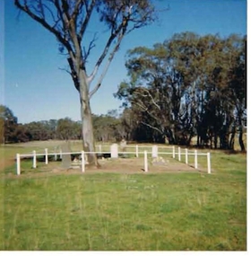
Photograph - HARRY BIGGS COLLECTION: PHOTO OF BOORT CEMETERY
... Bendigo goldfields MEMORIALS Graveboards Boort Cemetery Boort Cemetery Coutts family Coloured Photo of Boort Cemetery. Graves are enclosed with a white fence and a large tree is in the centre. Small and large trees are in the back ground. Photo was taken in 1964. 8.8 Inscription on the back of 2400 411a Early Settlers Cemetery dated 1964. Restoration by Russel Coutts of the graves at the homestead Dunbar, on the site of the old ...Coloured Photo of Boort Cemetery. Graves are enclosed with a white fence and a large tree is in the centre. Small and large trees are in the back ground. Photo was taken in 1964. 8.8 Inscription on the back of 2400 411a Early Settlers Cemetery dated 1964. Restoration by Russel Coutts of the graves at the homestead Dunbar, on the site of the old Boort Homestead.memorials, graveboards, boort cemetery, boort cemetery, coutts family -
 Bendigo Historical Society Inc.
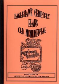
Book - EAGLEHAWK CEMETERY PLANS OLD MONUMENTAL
... Eaglehawk Cemetery Plans Old Monumental, researched by Annette O'Donohue and Bev Hanson contains 117 pages, printed by La Trobe University Bendigo printery....History House 11 Mackenzie Street Bendigo goldfields BOOK Bendigo eaglehawk Eaglehawk-Cemetery-Burials Annette O'Donohue/Bev Hanson Eaglehawk Cemetery Plans Old Monumental, researched by Annette O'Donohue and Bev Hanson contains 117 pages, printed by La Trobe University Bendigo printery. ...Eaglehawk Cemetery Plans Old Monumental, researched by Annette O'Donohue and Bev Hanson contains 117 pages, printed by La Trobe University Bendigo printery.Annette O'Donohue/Bev Hansonbook, bendigo, eaglehawk, eaglehawk-cemetery-burials -
 Bendigo Historical Society Inc.
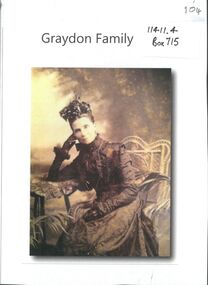
Photograph - Graydon and Richardson Families in Bendigo
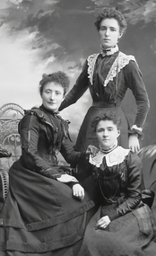
... Bendigo Art Gallery and the old Mechanics Institute. He was married at Daylesford in 1871. Mr James Richardson was interred in the Presbyterian section of the Bendigo Cemetery....Bendigo Art Gallery and the old Mechanics Institute. He was married at Daylesford in 1871. Mr James Richardson was interred in the Presbyterian section of the Bendigo Cemetery. ...Charles Wallace Gordon Graydon the First came out to Victoria on the S.S. Almora, the same ship on which Eliza Richardson and her family arrived on New Years Day 1875. Evidently C.W.G.G.1st. must have retained fond memories of a young fourteen-year-old girl named Elizabeth Richardson who travelled from Scotland with her mother and family (her father had arrived earlier) because three years later at Kyneton they were married. It was December 26th 1860, and Elizabeth was just seventeen. As the bridegroom’s age is written as 24 years on the wedding certificate, he certainly must have been more than eighteen when he sailed on the "Almora" in 1856. The newly married couple went to live at Taradale, Victoria, and they made a good life for themselves in that town which had then a thriving gold mine. They lived in a large two-storied house in Survey Paddock, and it was there that four daughters - Susan Emily (1861-1906), Elizabeth Constance (1863-1945), Amelia Amy (1865 -1952, Ada Mary Maude (1867-1901), and one son Newenham Edward Eustace (1869-1945) named after his Irish Grandfather, were born. On his wedding certificate C.W.G. Graydon, is described as a foreman. His father-in-law, Robert Richardson was employed as a time-keeper on the Melbourne to Bendigo Railway works, and he and his family lived first in Prahran, then Kyneton, and then Taradale. Perhaps Charles Graydon worked on the railway with him. In Taradale however, he worked for a gold mining company in a surveying capacity. C.W.G.G.1st was to become Shire President of the Shire of Metcalfe. That particular year the Graydon Family entertained the visiting English cricket Eleven at their home in Taradale. He was certainly regarded as an important man in the district when he was requested by a great number of the residents to nominate for the Legislative Assembly election. About 1876 the Graydons left Taradale, and went to live at Sandhurst, now Bendigo, at Barkly Place East. The Richardsons had also left Taradale to go into the grocery business in the same town. Charles Wallace Gordon Graydon the First became a legal manager of mines, and a well-known and popular resident. Sad to say he became ill with a lung infection, and on June 4th. 1885 he died, and was buried at Sandhurst, now Bendigo Cemetery, Back Creek Rd. Eliza Richardson's brother was Mr. James Richardson, the well-known grocer, of Pall Mall and Golden-square, who died at his residence, "Balgownie," Short street, on Thursday 22 Jan 1914. James Richardson was a native of Scotland. He was born at Glasgow in1849 and was only eight years of age when his parents sailed for Australia in the ship Balmoral. The family arrived in Melbourne in 1857 and went to Taradale, where Mr. Richardson, senr., acted as inspector of works during the construction of the Taradale Viaduct. James Richardson, who had commenced his educationin Glasgow, attended school at Taradale until the family removed to Bendigo at the time the railway was being built from Bendigo to Echuca. The contractors for this work engaged Mr Richardson, senr., as their timekeeper. When he left school James Richardson applied himself to learn the grocery business, and he gained a thorough knowledge of it with different employers at Bendigo, Taradale, and Daylesford. In 1872 he opened a grocery store on his own account in High-Street, Bendigo, but within a few months he had the great misfortune to be burnt out. The fire originated in an adjoining building early one morning and both places were burnt to the ground. In spite of his loss, Mr. Richardson was not discouraged, for he soon made another start. His trade improved and he extended his business, opening the Eclipse Cash Store at Golden Square. A little later another branch was opened at the Oddfellows' Hall, and subsequently this business was transferred to the Eureka Cash Store, in Pall Mall, which was the head depot. In addition to the retail trade, Mr. Richardson had, for many years carried on an extensive wholesale business with the Northern District, and had made a specialty of fodder seeds. James was a man of probity and sincerity in business, and as a citizen he was highly esteemed and respected. He was a prominent member of the Bendigo Caledonian Society in the earlier days of his citizenship. He was a staunch member of St Andrew's Presbyterian Church, and was a member of the board of management. In the Easter Fair procession, Mr Richardson's display was always a prominent and attractive one. Mr. Richardson was a member of the Masonic Order, and was a life member of the Bendigo Art Gallery and the old Mechanics Institute. He was married at Daylesford in 1871. Mr James Richardson was interred in the Presbyterian section of the Bendigo Cemetery.Digital Image. Copy of photograph of three of the four Graydon girls. Ada, Lizzie and Amelia Graydon. B&W photo of three women - two seated and one standing - Studio portrait.Lizzie (Elizabeth Constance 1863-1945) standing. Amelia (Amelia Amy 1865 - 1952) Seated on right. Ada (Ada Mary Maude 1867-1901) seated left.graydon girls., graydon collection, graydon richardson, james richardson grocer, bendigo history -
 Bendigo Historical Society Inc.
Photograph - GRAYDON COLLECTION: FAMILY PHOTOGRAPHS
... Bendigo Art Gallery and the old Mechanics Institute. He was married at Daylesford in 1871. Mr James Richardson was interred in the Presbyterian section of the Bendigo Cemetery....Bendigo Art Gallery and the old Mechanics Institute. He was married at Daylesford in 1871. Mr James Richardson was interred in the Presbyterian section of the Bendigo Cemetery. ...Charles Wallace Gordon Graydon the First came out to Victoria on the S.S. Almora, the same ship on which Eliza Richardson and her family arrived on New Years Day 1875. Evidently C.W.G.G.1st. must have retained fond memories of a young fourteen-year-old girl named Elizabeth Richardson who travelled from Scotland with her mother and family (her father had arrived earlier) because three years later at Kyneton they were married. It was December 26th 1860, and Elizabeth was just seventeen. As the bridegroom’s age is written as 24 years on the wedding certificate, he certainly must have been more than eighteen when he sailed on the "Almora" in 1856. The newly married couple went to live at Taradale, Victoria, and they made a good life for themselves in that town which had then a thriving gold mine. They lived in a large two-storied house in Survey Paddock, and it was there that four daughters - Susan Emily (1861-1906), Elizabeth Constance (1863-1945), Amelia Amy (1865 -1952, Ada Mary Maude (1867-1901), and one son Newenham Edward Eustace (1869-1945) named after his Irish Grandfather, were born. On his wedding certificate C.W.G. Graydon, is described as a foreman. His father-in-law, Robert Richardson was employed as a time-keeper on the Melbourne to Bendigo Railway works, and he and his family lived first in Prahran, then Kyneton, and then Taradale. Perhaps Charles Graydon worked on the railway with him. In Taradale however, he worked for a gold mining company in a surveying capacity. C.W.G.G.1st was to become Shire President of the Shire of Metcalfe. That particular year the Graydon Family entertained the visiting English cricket Eleven at their home in Taradale. He was certainly regarded as an important man in the district when he was requested by a great number of the residents to nominate for the Legislative Assembly election. About 1876 the Graydons left Taradale, and went to live at Sandhurst, now Bendigo, at Barkly Place East. The Richardsons had also left Taradale to go into the grocery business in the same town. Charles Wallace Gordon Graydon the First became a legal manager of mines, and a well-known and popular resident. Sad to say he became ill with a lung infection, and on June 4th. 1885 he died, and was buried at Sandhurst, now Bendigo Cemetery, Back Creek Rd. Eliza Richardson's brother was Mr. James Richardson, the well-known grocer, of Pall Mall and Golden-square, who died at his residence, "Balgownie," Short street, on Thursday 22 Jan 1914. James Richardson was a native of Scotland. He was born at Glasgow in1849 and was only eight years of age when his parents sailed for Australia in the ship Balmoral. The family arrived in Melbourne in 1857 and went to Taradale, where Mr. Richardson, senr., acted as inspector of works during the construction of the Taradale Viaduct. James Richardson, who had commenced his educationin Glasgow, attended school at Taradale until the family removed to Bendigo at the time the railway was being built from Bendigo to Echuca. The contractors for this work engaged Mr Richardson, senr., as their timekeeper. When he left school James Richardson applied himself to learn the grocery business, and he gained a thorough knowledge of it with different employers at Bendigo, Taradale, and Daylesford. In 1872 he opened a grocery store on his own account in High-Street, Bendigo, but within a few months he had the great misfortune to be burnt out. The fire originated in an adjoining building early one morning and both places were burnt to the ground. In spite of his loss, Mr. Richardson was not discouraged, for he soon made another start. His trade improved and he extended his business, opening the Eclipse Cash Store at Golden Square. A little later another branch was opened at the Oddfellows' Hall, and subsequently this business was transferred to the Eureka Cash Store, in Pall Mall, which was the head depot. In addition to the retail trade, Mr. Richardson had, for many years carried on an extensive wholesale business with the Northern District, and had made a specialty of fodder seeds. James was a man of probity and sincerity in business, and as a citizen he was highly esteemed and respected. He was a prominent member of the Bendigo Caledonian Society in the earlier days of his citizenship. He was a staunch member of St Andrew's Presbyterian Church, and was a member of the board of management. In the Easter Fair procession, Mr Richardson's display was always a prominent and attractive one. Mr. Richardson was a member of the Masonic Order, and was a life member of the Bendigo Art Gallery and the old Mechanics Institute. He was married at Daylesford in 1871. Mr James Richardson was interred in the Presbyterian section of the Bendigo Cemetery.A selection of Graydon and Richardson family photographs taken by Bendigo photograpers. all photos unnamed.photograph, person, graydon and richardson families. -
 Bendigo Historical Society Inc.
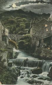
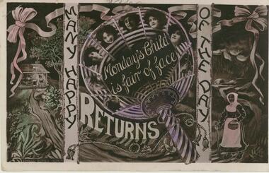
Postcard - Alice McGregor Postcard Collection, 1900 - 1920
... Bendigo in 1937 aged 26. In Victoria in 1938, Alice Mary Salter married James Thomas McGregor (born Victoria 1917, died Victoria 1983, buried Fawkner Cemetery) Lived: 1968; 22 Wade Street Golden Square Alice McGregor Died: 1999 aged 91 at Anne Caudle Centre, Bendigo Buried: Kangaroo Flat Cemetery See additional research. Postcard Album of Alice McGregor contained 86 post cards. POSTCARD Collector Alice McGregor Addressed to Miss Stapleton, Arcade, Bendigo Sender - E.N Stamp date 1905 Postcard Album of Alice McGregor containing 86 post cards. See 1400 Colour photo of 'Old ...Alice McGREGOR Born: 1908; unknown parents. Possibly adopted by the Salter family? Electoral Roll 1936: Highland Terrace Kangaroo Flat. Alice Mary Salter and William Robert Salter living together; presumed to be sister and brother. William Robert Salter was killed in a MVA in Bendigo in 1937 aged 26. In Victoria in 1938, Alice Mary Salter married James Thomas McGregor (born Victoria 1917, died Victoria 1983, buried Fawkner Cemetery) Lived: 1968; 22 Wade Street Golden Square Alice McGregor Died: 1999 aged 91 at Anne Caudle Centre, Bendigo Buried: Kangaroo Flat Cemetery See additional research. Postcard Album of Alice McGregor contained 86 post cards.Postcard Album of Alice McGregor containing 86 post cards. See 1400 Colour photo of 'Old Mill at Ambleside'. Stream with waterfall in foreground. Stone buildings either side. Waterwheel on LHS. Moon rising over hills in background Addressed to Miss Stapleton, Arcade, Bendigo Sender - E.N Stamp date 1905 postcard, collector, alice mcgregor -
 Bendigo Historical Society Inc.
Photograph - GRAYDON COLLECTION: FAMILY PHOTOGRAPHS
... Bendigo Art Gallery and the old Mechanics Institute. He was married at Daylesford in 1871. Mr James Richardson was interred in the Presbyterian section of the Bendigo Cemetery....Bendigo Art Gallery and the old Mechanics Institute. He was married at Daylesford in 1871. Mr James Richardson was interred in the Presbyterian section of the Bendigo Cemetery. ...Charles Wallace Gordon Graydon the First came out to Victoria on the S.S. Almora, the same ship on which Eliza Richardson and her family arrived on New Years Day 1875. Evidently C.W.G.G.1st. must have retained fond memories of a young fourteen-year-old girl named Elizabeth Richardson who travelled from Scotland with her mother and family (her father had arrived earlier) because three years later at Kyneton they were married. It was December 26th 1860, and Elizabeth was just seventeen. As the bridegroom’s age is written as 24 years on the wedding certificate, he certainly must have been more than eighteen when he sailed on the "Almora" in 1856. The newly married couple went to live at Taradale, Victoria, and they made a good life for themselves in that town which had then a thriving gold mine. They lived in a large two-storied house in Survey Paddock, and it was there that four daughters - Susan Emily (1861-1906), Elizabeth Constance (1863-1945), Amelia Amy (1865 -1952, Ada Mary Maude (1867-1901), and one son Newenham Edward Eustace (1869-1945) named after his Irish Grandfather, were born. On his wedding certificate C.W.G. Graydon, is described as a foreman. His father-in-law, Robert Richardson was employed as a time-keeper on the Melbourne to Bendigo Railway works, and he and his family lived first in Prahran, then Kyneton, and then Taradale. Perhaps Charles Graydon worked on the railway with him. In Taradale however, he worked for a gold mining company in a surveying capacity. C.W.G.G.1st was to become Shire President of the Shire of Metcalfe. That particular year the Graydon Family entertained the visiting English cricket Eleven at their home in Taradale. He was certainly regarded as an important man in the district when he was requested by a great number of the residents to nominate for the Legislative Assembly election. About 1876 the Graydons left Taradale, and went to live at Sandhurst, now Bendigo, at Barkly Place East. The Richardsons had also left Taradale to go into the grocery business in the same town. Charles Wallace Gordon Graydon the First became a legal manager of mines, and a well-known and popular resident. Sad to say he became ill with a lung infection, and on June 4th. 1885 he died, and was buried at Sandhurst, now Bendigo Cemetery, Back Creek Rd. Eliza Richardson's brother was Mr. James Richardson, the well-known grocer, of Pall Mall and Golden-square, who died at his residence, "Balgownie," Short street, on Thursday 22 Jan 1914. James Richardson was a native of Scotland. He was born at Glasgow in1849 and was only eight years of age when his parents sailed for Australia in the ship Balmoral. The family arrived in Melbourne in 1857 and went to Taradale, where Mr. Richardson, senr., acted as inspector of works during the construction of the Taradale Viaduct. James Richardson, who had commenced his educationin Glasgow, attended school at Taradale until the family removed to Bendigo at the time the railway was being built from Bendigo to Echuca. The contractors for this work engaged Mr Richardson, senr., as their timekeeper. When he left school James Richardson applied himself to learn the grocery business, and he gained a thorough knowledge of it with different employers at Bendigo, Taradale, and Daylesford. In 1872 he opened a grocery store on his own account in High-Street, Bendigo, but within a few months he had the great misfortune to be burnt out. The fire originated in an adjoining building early one morning and both places were burnt to the ground. In spite of his loss, Mr. Richardson was not discouraged, for he soon made another start. His trade improved and he extended his business, opening the Eclipse Cash Store at Golden Square. A little later another branch was opened at the Oddfellows' Hall, and subsequently this business was transferred to the Eureka Cash Store, in Pall Mall, which was the head depot. In addition to the retail trade, Mr. Richardson had, for many years carried on an extensive wholesale business with the Northern District, and had made a specialty of fodder seeds. James was a man of probity and sincerity in business, and as a citizen he was highly esteemed and respected. He was a prominent member of the Bendigo Caledonian Society in the earlier days of his citizenship. He was a staunch member of St Andrew's Presbyterian Church, and was a member of the board of management. In the Easter Fair procession, Mr Richardson's display was always a prominent and attractive one. Mr. Richardson was a member of the Masonic Order, and was a life member of the Bendigo Art Gallery and the old Mechanics Institute. He was married at Daylesford in 1871. Mr James Richardson was interred in the Presbyterian section of the Bendigo Cemetery.A selection of black and white Graydon and Richardson family photographs taken by Bendigo photographers. All photos unnamed. Mounted as Cabinet cards. Photographers - D. Mendelfson, Bartlett Bros., The Studio - Chuck, Eden Society Studios, Alan Spicer, R. Bloomfield Rees,graydon, richardson, cabinet card -
 Bendigo Historical Society Inc.
Photograph - GRAYDON COLLECTION: FAMILY PHOTOGRAPHS
... Bendigo Art Gallery and the old Mechanics Institute. He was married at Daylesford in 1871. Mr James Richardson was interred in the Presbyterian section of the Bendigo Cemetery....Bendigo Art Gallery and the old Mechanics Institute. He was married at Daylesford in 1871. Mr James Richardson was interred in the Presbyterian section of the Bendigo Cemetery. ...Charles Wallace Gordon Graydon the First came out to Victoria on the S.S. Almora, the same ship on which Eliza Richardson and her family arrived on New Years Day 1875. Evidently C.W.G.G.1st. must have retained fond memories of a young fourteen-year-old girl named Elizabeth Richardson who travelled from Scotland with her mother and family (her father had arrived earlier) because three years later at Kyneton they were married. It was December 26th 1860, and Elizabeth was just seventeen. As the bridegroom’s age is written as 24 years on the wedding certificate, he certainly must have been more than eighteen when he sailed on the "Almora" in 1856. The newly married couple went to live at Taradale, Victoria, and they made a good life for themselves in that town which had then a thriving gold mine. They lived in a large two-storied house in Survey Paddock, and it was there that four daughters - Susan Emily (1861-1906), Elizabeth Constance (1863-1945), Amelia Amy (1865 -1952, Ada Mary Maude (1867-1901), and one son Newenham Edward Eustace (1869-1945) named after his Irish Grandfather, were born. On his wedding certificate C.W.G. Graydon, is described as a foreman. His father-in-law, Robert Richardson was employed as a time-keeper on the Melbourne to Bendigo Railway works, and he and his family lived first in Prahran, then Kyneton, and then Taradale. Perhaps Charles Graydon worked on the railway with him. In Taradale however, he worked for a gold mining company in a surveying capacity. C.W.G.G.1st was to become Shire President of the Shire of Metcalfe. That particular year the Graydon Family entertained the visiting English cricket Eleven at their home in Taradale. He was certainly regarded as an important man in the district when he was requested by a great number of the residents to nominate for the Legislative Assembly election. About 1876 the Graydons left Taradale, and went to live at Sandhurst, now Bendigo, at Barkly Place East. The Richardsons had also left Taradale to go into the grocery business in the same town. Charles Wallace Gordon Graydon the First became a legal manager of mines, and a well-known and popular resident. Sad to say he became ill with a lung infection, and on June 4th. 1885 he died, and was buried at Sandhurst, now Bendigo Cemetery, Back Creek Rd. Eliza Richardson's brother was Mr. James Richardson, the well-known grocer, of Pall Mall and Golden-square, who died at his residence, "Balgownie," Short street, on Thursday 22 Jan 1914. James Richardson was a native of Scotland. He was born at Glasgow in1849 and was only eight years of age when his parents sailed for Australia in the ship Balmoral. The family arrived in Melbourne in 1857 and went to Taradale, where Mr. Richardson, senr., acted as inspector of works during the construction of the Taradale Viaduct. James Richardson, who had commenced his educationin Glasgow, attended school at Taradale until the family removed to Bendigo at the time the railway was being built from Bendigo to Echuca. The contractors for this work engaged Mr Richardson, senr., as their timekeeper. When he left school James Richardson applied himself to learn the grocery business, and he gained a thorough knowledge of it with different employers at Bendigo, Taradale, and Daylesford. In 1872 he opened a grocery store on his own account in High-Street, Bendigo, but within a few months he had the great misfortune to be burnt out. The fire originated in an adjoining building early one morning and both places were burnt to the ground. In spite of his loss, Mr. Richardson was not discouraged, for he soon made another start. His trade improved and he extended his business, opening the Eclipse Cash Store at Golden Square. A little later another branch was opened at the Oddfellows' Hall, and subsequently this business was transferred to the Eureka Cash Store, in Pall Mall, which was the head depot. In addition to the retail trade, Mr. Richardson had, for many years carried on an extensive wholesale business with the Northern District, and had made a specialty of fodder seeds. James was a man of probity and sincerity in business, and as a citizen he was highly esteemed and respected. He was a prominent member of the Bendigo Caledonian Society in the earlier days of his citizenship. He was a staunch member of St Andrew's Presbyterian Church, and was a member of the board of management. In the Easter Fair procession, Mr Richardson's display was always a prominent and attractive one. Mr. Richardson was a member of the Masonic Order, and was a life member of the Bendigo Art Gallery and the old Mechanics Institute. He was married at Daylesford in 1871. Mr James Richardson was interred in the Presbyterian section of the Bendigo Cemetery.Seventeen black and white Graydon and Richardson family photographs taken by Bendigo photographers. All photos unnamed. Mounted as Cartes de Visite. Photographers - The Studio - Chuck, , M. Bent, F. de Kock and Co., N. White, Bartlett Bros., Chevalier.graydon, richardson, carte de visite -
 Bendigo Historical Society Inc.
Mixed media - GRAYDON COLLECTION: FAMILY PHOTOGRAPHS and NOTES (See ITEM 11411)
... Bendigo Art Gallery and the old Mechanics Institute. He was married at Daylesford in 1871. Mr James Richardson was interred in the Presbyterian section of the Bendigo Cemetery....Bendigo Art Gallery and the old Mechanics Institute. He was married at Daylesford in 1871. Mr James Richardson was interred in the Presbyterian section of the Bendigo Cemetery. ...Charles Wallace Gordon Graydon the First came out to Victoria on the S.S. Almora, the same ship on which Eliza Richardson and her family arrived on New Years Day 1875. Evidently C.W.G.G.1st. must have retained fond memories of a young fourteen-year-old girl named Elizabeth Richardson who travelled from Scotland with her mother and family (her father had arrived earlier) because three years later at Kyneton they were married. It was December 26th, 1860, and Elizabeth was just seventeen. As the bridegroom’s age is written as 24 years on the wedding certificate, he certainly must have been more than eighteen when he sailed on the "Almora" in 1856. The newly married couple went to live at Taradale, Victoria, and they made a good life for themselves in that town which had then a thriving gold mine. They lived in a large two-storied house in Survey Paddock, and it was there that four daughters - Susan Emily (1861-1906), Elizabeth Constance (1863-1945), Amelia Amy (1865 -1952, Ada Mary Maude (1867-1901), and one son Newenham Edward Eustace (1869-1945) named after his Irish Grandfather, were born. On his wedding certificate C.W.G. Graydon, is described as a foreman. His father-in-law, Robert Richardson was employed as a timekeeper on the Melbourne to Bendigo Railway works, and he and his family lived first in Prahran, then Kyneton, and then Taradale. Perhaps Charles Graydon worked on the railway with him. In Taradale however, he worked for a gold mining company in a surveying capacity. C.W.G.G.1st was to become Shire President of the Shire of Metcalfe. That particular year the Graydon Family entertained the visiting English cricket Eleven at their home in Taradale. He was certainly regarded as an important man in the district when he was requested by a great number of the residents to nominate for the Legislative Assembly election. About 1876 the Graydons left Taradale, and went to live at Sandhurst, now Bendigo, at Barkly Place East. The Richardsons had also left Taradale to go into the grocery business in the same town. Charles Wallace Gordon Graydon the First became a legal manager of mines, and a well-known and popular resident. Sad to say he became ill with a lung infection, and on June 4th. 1885 he died, and was buried at Sandhurst, now Bendigo Cemetery, Back Creek Rd. Eliza Richardson's brother was Mr. James Richardson, the well-known grocer, of Pall Mall and Golden-square, who died at his residence, "Balgownie," Short Street, on Thursday 22 Jan 1914. James Richardson was a native of Scotland. He was born at Glasgow in1849 and was only eight years of age when his parents sailed for Australia in the ship Balmoral. The family arrived in Melbourne in 1857 and went to Taradale, where Mr. Richardson, senior., acted as inspector of works during the construction of the Taradale Viaduct. James Richardson, who had commenced his education in Glasgow, attended school at Taradale until the family removed to Bendigo at the time the railway was being built from Bendigo to Echuca. The contractors for this work engaged Mr. Richardson, as their timekeeper. When he left school James Richardson applied himself to learn the grocery business, and he gained a thorough knowledge of it with different employers at Bendigo, Taradale, and Daylesford. In 1872 he opened a grocery store on his own account in High-Street, Bendigo, but within a few months he had the great misfortune to be burnt out. The fire originated in an adjoining building early one morning and both places were burnt to the ground. In spite of his loss, Mr. Richardson was not discouraged, for he soon made another start. His trade improved and he extended his business, opening the Eclipse Cash Store at Golden Square. A little later another branch was opened at the Oddfellows' Hall, and subsequently this business was transferred to the Eureka Cash Store, in Pall Mall, which was the head depot. In addition to the retail trade, Mr. Richardson had, for many years carried on an extensive wholesale business with the Northern District and had made a specialty of fodder seeds. James was a man of probity and sincerity in business, and as a citizen he was highly esteemed and respected. He was a prominent member of the Bendigo Caledonian Society in the earlier days of his citizenship. He was a staunch member of St Andrew's Presbyterian Church, and was a member of the board of management. In the Easter Fair procession, Mr. Richardson's display was always a prominent and attractive one. Mr. Richardson was a member of the Masonic Order and was a life member of the Bendigo Art Gallery and the old Mechanics Institute. He was married at Daylesford in 1871. Mr James Richardson was interred in the Presbyterian section of the Bendigo Cemetery.DVD A selection of Graydon and Richardson family photographs taken by Bendigo photographers, and family history notesphotograph, person, graydon and richardson families. -
 Bendigo Historical Society Inc.
Postcard - Alice McGregor Postcard Collection, 1900 - 1920
... Cemetery) Lived: 1968; 22 Wade Street Golden Square Alice McGregor Died: 1999 aged 91 at Anne Caudle Centre, Bendigo Buried: Kangaroo Flat Cemetery See additional research. Postcard Album of Alice McGregor contained 86 post cards. POSTCARD Collector Alice McGregor Addressed to Miss A. Stapleton, Arcade, Bendigo Sender - not known Dated 22.2.09 Postcard Album of Alice McGregor containing 86 post cards. See 1400. Purple coloured Birthday Postcard. In centre circle 'Monday's Child is fair of face.' surrounded by faces of young girls. On the left is a cottage and on the right is an old ...Alice McGREGOR Born: 1908; unknown parents. Possibly adopted by the Salter family? Electoral Roll 1936: Highland Terrace Kangaroo Flat. Alice Mary Salter and William Robert Salter living together; presumed to be sister and brother. William Robert Salter was killed in a MVA in Bendigo in 1937 aged 26. In Victoria in 1938, Alice Mary Salter married James Thomas McGregor (born Victoria 1917, died Victoria 1983, buried Fawkner Cemetery) Lived: 1968; 22 Wade Street Golden Square Alice McGregor Died: 1999 aged 91 at Anne Caudle Centre, Bendigo Buried: Kangaroo Flat Cemetery See additional research. Postcard Album of Alice McGregor contained 86 post cards.Postcard Album of Alice McGregor containing 86 post cards. See 1400. Purple coloured Birthday Postcard. In centre circle 'Monday's Child is fair of face.' surrounded by faces of young girls. On the left is a cottage and on the right is an old woman Addressed to Miss A. Stapleton, Arcade, Bendigo Sender - not known Dated 22.2.09 postcard, collector, alice mcgregor -
 Bendigo Historical Society Inc.
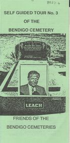
Document - BENDIGO CEMETERIES COLLECTION: SELF GUIDED TOUR NO.3 DOCUMENT
... Bendigo Cemetery. On front, headstone image of William Roy Leach. Map of cemetery with numbered graves described e.g. Lady Jane Lamsey, honoured by Emperor of Chinese , Oscar Flight, Flight's Band 80 years dedicated to music. On back fold: this tour takes you past graves of some of Roy's old...BENDIGO Cemetery bendigo cemetery tour Friends of the Bendigo Cemeteries Inc. 1 May 1994. Green trifold document: Self Guided Tour No. 3 of the Bendigo Cemetery. On front, headstone image of William Roy Leach. Map of cemetery with numbered graves described e.g. Lady Jane Lamsey, honoured by Emperor of Chinese , Oscar Flight, Flight's Band 80 years dedicated to music. On back fold: this tour takes you past graves of some of Roy's old ...BHS CollectionGreen trifold document: Self Guided Tour No. 3 of the Bendigo Cemetery. On front, headstone image of William Roy Leach. Map of cemetery with numbered graves described e.g. Lady Jane Lamsey, honoured by Emperor of Chinese , Oscar Flight, Flight's Band 80 years dedicated to music. On back fold: this tour takes you past graves of some of Roy's old friends, as well as neglected graves, some bearing family names still found in the business directories of BendigoFriends of the Bendigo Cemeteries Inc. 1 May 1994.bendigo, cemetery, bendigo cemetery tour -
 Bendigo Historical Society Inc.
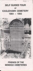
Document - BENDIGO CEMETERIES COLLECTION: SELF GUIDED TOUR EAGLEHAWK CEMETERY DOCUMENT
... Self guided tour of Eaglehawk Cemetery 1864 - 1993 Friends of the Bendigo Cemeteries. Document details significant graves in the old monumental section 1864 - Map of graves and 35 graves described....BENDIGO Cemetery eaglehawk cemetery Annette O'Donohue, Bev Hanson. White trifold document. Self guided tour of Eaglehawk Cemetery 1864 - 1993 Friends of the Bendigo Cemeteries. Document details significant graves in the old ...BHS CollectionWhite trifold document. Self guided tour of Eaglehawk Cemetery 1864 - 1993 Friends of the Bendigo Cemeteries. Document details significant graves in the old monumental section 1864 - Map of graves and 35 graves described.Annette O'Donohue, Bev Hanson.bendigo, cemetery, eaglehawk cemetery -
 Bendigo Historical Society Inc.
Book - STRAUCH COLLECTION: WHERE THEY LIE
... History House 11 Mackenzie Street Bendigo goldfields BHS Collection BENDIGO Cemetery early burials Bendigo-history-burials-cemetery Annette o'Donohue & Bev Hanson Where They Lie early burials on the Bendigo goldfields 1852-1870 includes list of interments for Old Sandhurst Burial ground and strays. 152 pages with black & white photographs. ...BHS CollectionWhere They Lie early burials on the Bendigo goldfields 1852-1870 includes list of interments for Old Sandhurst Burial ground and strays. 152 pages with black & white photographs.Annette o'Donohue & Bev Hansonbendigo, cemetery, early burials, bendigo-history-burials-cemetery -
 Bendigo Historical Society Inc.
Photograph - NICHOLAS CAIRE VIEWS OF BENDIGO
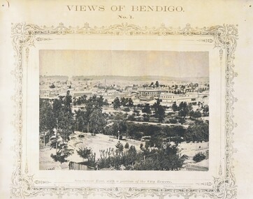
... Paul's tower. 30) View of the Sandhurst cemetery at back creek. 31) Kock's pioneer quartz crushing plant, Long Gully. 32) The New Masonic Hall, Sandhurst. 33) The Bendigo benevolent asylum and industrial school. 34) Bendigo flat as seen from Wattle Hill. 35) View of Old Chum Hill. 36) New Chum Gully as seen from Specimen Hill. 37) Township of Eaglehawk. 38) View from St. ...Paul's tower. 30) View of the Sandhurst cemetery at back creek. 31) Kock's pioneer quartz crushing plant, Long Gully. 32) The New Masonic Hall, Sandhurst. 33) The Bendigo benevolent asylum and industrial school. 34) Bendigo flat as seen from Wattle Hill. 35) View of Old Chum Hill. 36) New Chum Gully as seen from Specimen Hill. 37) Township of Eaglehawk. 38) View from St. ...Full set (52 photos) of Nicholas Caire ''Views of Bendigo'' photographs. 1) Sandhurst East with a portion of the City Reserve. 2) New Chum line of reef. 3) Sandhurst-North part as seen from the top of the Masonic Hall. 4) The Hustler's line of reef seen from Redan Hill. 5) Battery of stampers for crushing quartz 6) View of Sandhurst as seen from the top of the New Masonic Hall. 7) Excavation of quartz reef near Ironbark Hill. 8) St. Paul's Church, tower and belfry. 9) View of the Camp Reserve as seen from the Court House. 10) View of North Old Chum showing surface excavations. 11) View as seen from the Camp Hill near the lodge. 12) Garden Gully amalgamated claims. 13) Shamrock Hotel, Sandhurst. 14) View as seen from Court House showing the willows & East Pall Mall. 15) Wesleyan Church, Golden Square. 16) Savings bank, Sandhurst. 17) The Bendigo district hospital. 18) Interior of the Wesleyan Church, Golden Square. 19) View of Golden Square township. 20) The Town Hall, City of Sandhurst. 21) The City Hotel, Sandhurst. 22) Pall Mall, Sandhurst. 23) Sandhurst City Market. 24) Pall Mall, Sandhurst looking west. 25) View from Camp Hill looking north - east 26) View of Charing Cross, Sandhurst. 27) View of Sandhurst as seen from Knipe's Castle. 28) Township of Long Gully. 29) View taken from St. Paul's tower. 30) View of the Sandhurst cemetery at back creek. 31) Kock's pioneer quartz crushing plant, Long Gully. 32) The New Masonic Hall, Sandhurst. 33) The Bendigo benevolent asylum and industrial school. 34) Bendigo flat as seen from Wattle Hill. 35) View of Old Chum Hill. 36) New Chum Gully as seen from Specimen Hill. 37) Township of Eaglehawk. 38) View from St. Paul's tower looking south west. 39) View of the railway tunnel through the Big Hill, near Mt. Herbert. 40) View taken from St. Paul's looking south. 41) Scene taken from St. Paul's tower looking eastward. 42) View of Sandhurst from St. Paul's tower looking north-west. 43) The great extended Hustler's co's. quartz mining claim. 44) View from the Big Hill showing the line of railway to Melbourne. 45) View from St. Paul's Church tower looking westward. 46) View from St. Paul's Church tower looking north-west. 47) Scene near the Big Hill ranges taken from Mr. Buick's residence. 48) View from St. Paul's Church tower looking north eastward. 49) Township of Eaglehawk 50) View of Mitchell Street, Sandhurst. 51) Botanical gardens near the White Hills. 52) View Point, Sandhurst.bendigo, streetscape, various views, nicholas cairne -
 Bendigo Historical Society Inc.
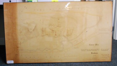
Map - CONTOUR PLAN OF THE GOVERNMENT CAMP SANDHURST 1854, 1994
... Bendigo Creek... Commissioner's Gully... View Place (now View Street)... Post Office... Bank of Victoria... District Surgeon... Sandhurst Fire Brigade... Police Hospital... Flagstaff... Gold Office... License Shed... Military Barracks... Stables... Commissioner's Buildings... Police Office. Old Cemetery...Shown on map: Pall Mall, Bendigo Creek, Commissioner's Gully, View Place (now View Street), Post Office, Bank of Victoria, District Surgeon, Sandhurst Fire Brigade, Police Hospital, Flagstaff, Gold Office, License Shed, Military Barracks, Stables, Commissioner's Buildings, Police Office. Old Cemetery...History House 11 Mackenzie Street Bendigo goldfields MAP Bendigo government camp Pall Mall Bendigo Creek Commissioner's Gully View Place (now View Street) Post Office Bank of Victoria District Surgeon Sandhurst Fire Brigade Police Hospital Flagstaff Gold Office License Shed Military Barracks Stables Commissioner's Buildings Police Office. Old Cemetery ...Contour map (copy) of the Government Camp Sandhurst, 1854. Map is mounted on coreflute and laminated. Written in bottom righthand corner 'Contour Plan of the Government Camp, Sandhurst. Dec 1854. Signed by Richard Larritt, Assistant Surveyor, 11th December 1854.' Shown on map: Pall Mall, Bendigo Creek, Commissioner's Gully, View Place (now View Street), Post Office, Bank of Victoria, District Surgeon, Sandhurst Fire Brigade, Police Hospital, Flagstaff, Gold Office, License Shed, Military Barracks, Stables, Commissioner's Buildings, Police Office. Old Cemetery, Garden. Reference on righthand side: 'Stone or brick buildings are tinted in crimson. Wooden buildings tinted in Indian Ink. Tents and other temporary structures tinted in Burnt Sienna.' Scale of Chains, on bottom of map. Sticker on bottom left hand corner and back of map ' Presented by Survey and Mapping, Victoria, 7th Octber, 1994'.map, bendigo, government camp, pall mall, bendigo creek, commissioner's gully, view place (now view street), post office, bank of victoria, district surgeon, sandhurst fire brigade, police hospital, flagstaff, gold office, license shed, military barracks, stables, commissioner's buildings, police office. old cemetery, garden. , survey and mapping victoria. sandhurst, bendigo. -
 Bendigo Historical Society Inc.
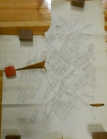
Document - MARKS COLLECTION: PLAN OF SANDHURST CITY CENTRE AND SURROUNDING AREA ( NO. 1 )
... History House 11 Mackenzie Street Bendigo goldfields BENDIGO Planning sandhurst 1867 Plan on heavy parchment - section neatly cut out of area now Kennington. Written on plan in black print ' Sheet No. 1. Sandhurst'. Plan shows Government Camp, Commissioner's Gully, old cemetery ...Plan on heavy parchment - section neatly cut out of area now Kennington. Written on plan in black print ' Sheet No. 1. Sandhurst'. Plan shows Government Camp, Commissioner's Gully, old cemetery site, manure depot, cattle market, Benevolent Asylum Reserve, railway reserve. Landowners' names on allotments. On bottom lithographed at the Department of Lands and Survey, Melbourne, by D. Henerson, March 12th., 1867 Plan part of George Lansell, Fortuna auction, documents found in wardrobe purchased by Marks family in 1930's.bendigo, planning, sandhurst 1867 -
 Bendigo Historical Society Inc.
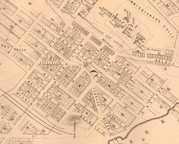
Map - MARKS COLLECTION: MAP SANDHURST 1867
... Original map: Sandhurst 1867, shows central Bendigo and surrounds, including police camp, stockade, 'old cemetery', reserve for. ...History House 11 Mackenzie Street Bendigo goldfields MAP Bendigo 1867 sandhurst map Original map: Sandhurst 1867, shows central Bendigo and surrounds, including police camp, stockade, 'old cemetery', reserve for. ...Original map: Sandhurst 1867, shows central Bendigo and surrounds, including police camp, stockade, 'old cemetery', reserve for. On bottom of map: 'Lithographed at the Department of Lands and Survey by D. Henderson, 20 February, 1867'. On top RH corner 'Sheet No 1 Sandhurst'.map, bendigo, 1867 sandhurst map -
 Federation University Historical Collection
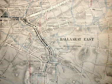
Map, Ballaarat Gold Field, 1861, 21/10/1861
... old post office hill...pennyweight hill...claytons hill...golden point...mining...railway...cricket ground...swamp creek...cemetery...sludge reserve...bakery hill...gaelic church...juvenile reformatory...orphanage...specimen hill...eureka lead...cattle yard hill...dalton's flat...chinese village...poverty hill...railway reserve...little bendigo...In November 2004 the Central Highlands Regional Library presented a special edition of 200 copies of the 1861 map reproduced from a copy in their collection. ballarat map davidson robert brough-smyth fitzpatrick cowan yuille's swamp public garden reserve manure depot black hill ballarat east old post office hill pennyweight hill claytons hill golden point mining railway cricket ground swamp creek cemetery sludge reserve bakery hill gaelic church juvenile reformatory orphanage specimen hill eureka lead cattle yard hill dalton's flat chinese village poverty hill railway reserve little bendigo diggings pound reserve allied armies flour mill agricultural reserve marsh survey reserve survey corps white flat yarrowee yarrowee creek brache j. brache survey ballaarat gold field 1861 Compiled & Drawn from the Survey of Mining Surveyors Davidson, Fitzpatrick and Cowan & the Plans in the Surveyor General's Office by J. ...A party of surveyors camped by Yuille's Swamp (later Lake Wendouree) and surveyed the countryside for a map to be produced by the Geological Survey of Victoria. In November 2004 the Central Highlands Regional Library presented a special edition of 200 copies of the 1861 map reproduced from a copy in their collection. Original geological map of Ballarat showing property, waterways, mines, churches, schools, water races, and garden reserves. It was compiled and drawn from the surveys of Mining Surveyors Davidson, Fitzpatrick and Cowan.Compiled & Drawn from the Survey of Mining Surveyors Davidson, Fitzpatrick and Cowan & the Plans in the Surveyor General's Office by J. Brahe, 21st October 1861. R. Brough Smyth, Secretary for Mines. The Honourable J.B. Humffray, M.L.A. Commr of Mines.ballarat, map, davidson, robert brough-smyth, fitzpatrick, cowan, yuille's swamp, public garden reserve, manure depot, black hill, ballarat east, old post office hill, pennyweight hill, claytons hill, golden point, mining, railway, cricket ground, swamp creek, cemetery, sludge reserve, bakery hill, gaelic church, juvenile reformatory, orphanage, specimen hill, eureka lead, cattle yard hill, dalton's flat, chinese village, poverty hill, railway reserve, little bendigo diggings, pound reserve, allied armies, flour mill, agricultural reserve, marsh, survey reserve, survey corps, white flat, yarrowee, yarrowee creek, brache, j. brache, survey, ballaarat gold field 1861 -
 Bendigo Historical Society Inc.
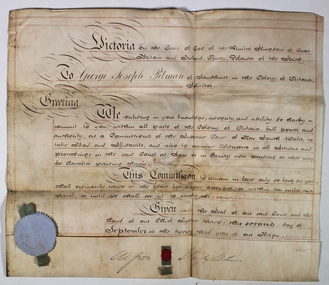
Certificate - George Josph Pittman Solicitor Certificate, 02/09/1860
... Old Church, St Pancras, London, England, United Kingdom. They were the parents of at least 3 sons and 7 daughters. He immigrated to Port Adelaide, South Australia, Australia in 1850 and lived in Barnstaple, Devon, England, United Kingdom in 1841. In 1856, his occupation is listed as solicitor in Bendigo, Victoria, Australia. He died on 14 January 1896, in Hawthorn, Victoria, Australia, at the age of 92, and was buried Kew Cemetery...Old Church, St Pancras, London, England, United Kingdom. They were the parents of at least 3 sons and 7 daughters. He immigrated to Port Adelaide, South Australia, Australia in 1850 and lived in Barnstaple, Devon, England, United Kingdom in 1841. In 1856, his occupation is listed as solicitor in Bendigo, Victoria, Australia. He died on 14 January 1896, in Hawthorn, Victoria, Australia, at the age of 92, and was buried Kew Cemetery ...George Joseph Pitman was born on 2 May 1803, in Bristol, England, his father, Thomas Dix Pitman, was 40 and his mother, Anna Simmonds, was 38. He married Clara Matilda Hamilton on 15 November 1827, in St Pancras Old Church, St Pancras, London, England, United Kingdom. They were the parents of at least 3 sons and 7 daughters. He immigrated to Port Adelaide, South Australia, Australia in 1850 and lived in Barnstaple, Devon, England, United Kingdom in 1841. In 1856, his occupation is listed as solicitor in Bendigo, Victoria, Australia. He died on 14 January 1896, in Hawthorn, Victoria, Australia, at the age of 92, and was buried Kew Cemetery Boroondara Victoriahttps://ancestors.familysearch.org/en/L77X-BQS/george-joseph-pitman-1803-1896g George Joseph Pitman is believed to be the first solicitor on the Sandhurst Gold FieldAn off white coloured thick paper with black writing and red lines Victoria by the Grace of God of The United Kingdom of Great Britain and Ireland, Queen. Defender of the Faith To Geoge Joseph Pitman of Sandhurst in the Colony of Victoria, Solicitor. Greeting, We confiding in your knowledge, integrity, and ability to herby commit to you within all parts of the Colony of Victoria, full power and authority as a Commissioner of the Supreme court of New South Wales take Bail and affidavits and also to examine Witnesses in all (unreadable) and proceedings in the said Court at Law or in Equity now knowing or that may be grafted pounding therein. This Commission to remain in force only so long as you shall continually reside at the place first described or within ten miles thereof, or until we shall see fit to revoke the same. Given under the Seal of our said Court and hand of our Chief Justice thereof this second day of September in the twenty third year of our reign An impression of THE SEAL OF THE SUPREME COURT OF THE COLONY OF VICTORIA (originally attached to the document with a piece of silk) with an illegible signature on both sides. george joseph pitman, bendigo's first solicitor, solicitor certificate -
 Box Hill Historical Society
Book, Hansen, D.E. Hansen, I.V. eds, St. Catherine's A Centenary celebration, 1996
... Cemeteries Box Hill Langley> Hilda Sarah A history of St. Catherine's School in Heyington Place, Toorak - one of Australia's finest independent girls' schools. It was opened in 1896. The school passed in 1903 to the Langley sisters, daughters of the Anglican Bishop of Bendigo, who re-named it St. Catherine's, after their old ...A history of St. Catherine's School in Heyington Place, Toorak - one of Australia's finest independent girls' schools. It was opened in 1896. The school passed in 1903 to the Langley sisters, daughters of the Anglican Bishop of Bendigo, who re-named it St. Catherine's, after their old school in Sydney. In 1920 Flora Templeton became co-principal with Ruth Langley when the school re-established itself in Melbourne. Ruth and her sister, Hilda, are both buried in Box Hill Cemetery.321 pagesA history of St. Catherine's School in Heyington Place, Toorak - one of Australia's finest independent girls' schools. It was opened in 1896. The school passed in 1903 to the Langley sisters, daughters of the Anglican Bishop of Bendigo, who re-named it St. Catherine's, after their old school in Sydney. In 1920 Flora Templeton became co-principal with Ruth Langley when the school re-established itself in Melbourne. Ruth and her sister, Hilda, are both buried in Box Hill Cemetery.langley> minnie ruth, box hill cemetery, cemeteries, box hill, langley> hilda sarah -
 Ballarat Heritage Services
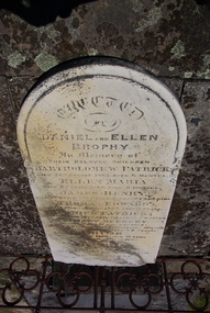
Photograph - Photograph - Colour, Clare Gervasoni, Brophy Gravestone at the Ballaarat Old Cemetery, 2013, 2013
... Bendigo and Taradale. He was a Knight of the Order of St George, mining manager, mining Investor and hotelkeeper. In 1859 he had married Ellen Mary Berkery; he was survived by five of their ten children. ballaarat old cemetery eureka stockade daniel brophy ellen brophy bartholomew brophy ellen maria brophy james henry brophy thomas edward brophy mary berkery daniel patrick brophy william brophy Ellen Berkery Colour photographs of the Brophy headstone in the Ballaarat Old Cemetery . ...Daniel Brophy was born on 13 November 1832 at Castlecomer, County Kilkenny, Ireland. He was the youngest son of William Brophy, farmer, and his wife Margaret Purcell. In the Irish rebellion of 1798 the family estates had been confiscated. William Brophy escaped to Newfoundland returning after fourteen years and regained some of his property. Daniel Brophy was educated in local schools including a Quakers school. At 15 Daniel Brophy went with his family to Quebec in a migrant ship whose passengers were decimated by fever. His mother died on the voyage and his father soon after landing. Daniel found work in a shipyard but did not like it and entered a grocery warehouse. Brophy arrived at Melbourne in 1853 in search of gold. With four Irish friends he set off for Bendigo on foot. Water was scarce on the track and they worked at a quarry near Keilor until the winter rains began. The party was credited with the first discovery of payable gold at Taradale, but by 1855 they had moved to Ballarat. There Daniel Brophy proved himself a shrewd investor in many successful mining ventures. He started as the first sluice man in the Great Extended Mine and later became a director and chairman when it was renamed the Band of Hope and Albion; its total yield was about £3,000,000. Brophy also invested in a Ballarat hotel which he greatly enlarged and in landed property. An enthusiastic promoter of local industries, he became a director of the Phoenix Foundry Co. and of the Ballarat Woollen Mills. Brophy was an Irish Nationalist who first dug for gold at Bendigo and Taradale. He was a Knight of the Order of St George, mining manager, mining Investor and hotelkeeper. In 1859 he had married Ellen Mary Berkery; he was survived by five of their ten children.Colour photographs of the Brophy headstone in the Ballaarat Old Cemetery . ballaarat old cemetery, eureka stockade, daniel brophy, ellen brophy, bartholomew brophy, ellen maria brophy, james henry brophy, thomas edward brophy, mary berkery, daniel patrick brophy, william brophy, ellen berkery -
 Ballarat Heritage Services
Photograph - Photograph - Colour, Clare Gervasoni, Daniel Brophy
... Bendigo and Taradale. He was a Knight of the Order of St George, mining manager, mining Investor and hotelkeeper. In 1859 he had married Ellen Mary Berkery; he was survived by five of their ten children. ballaarat old cemetery eureka stockade daniel brophy ellen brophy bartholomew brophy ellen maria brophy james henry brophy thomas edward brophy mary berkery daniel patrick brophy william brophy Ellen Berkery Black and white image of Daniel Brophy . ...Daniel Brophy was born on 13 November 1832 at Castlecomer, County Kilkenny, Ireland. He was the youngest son of William Brophy, farmer, and his wife Margaret Purcell. In the Irish rebellion of 1798 the family estates had been confiscated. William Brophy escaped to Newfoundland returning after fourteen years and regained some of his property. Daniel Brophy was educated in local schools including a Quakers school. At 15 Daniel Brophy went with his family to Quebec in a migrant ship whose passengers were decimated by fever. His mother died on the voyage and his father soon after landing. Daniel found work in a shipyard but did not like it and entered a grocery warehouse. Brophy arrived at Melbourne in 1853 in search of gold. With four Irish friends he set off for Bendigo on foot. Water was scarce on the track and they worked at a quarry near Keilor until the winter rains began. The party was credited with the first discovery of payable gold at Taradale, but by 1855 they had moved to Ballarat. There Daniel Brophy proved himself a shrewd investor in many successful mining ventures. He started as the first sluice man in the Great Extended Mine and later became a director and chairman when it was renamed the Band of Hope and Albion; its total yield was about £3,000,000. Brophy also invested in a Ballarat hotel which he greatly enlarged and in landed property. An enthusiastic promoter of local industries, he became a director of the Phoenix Foundry Co. and of the Ballarat Woollen Mills. Brophy was an Irish Nationalist who first dug for gold at Bendigo and Taradale. He was a Knight of the Order of St George, mining manager, mining Investor and hotelkeeper. In 1859 he had married Ellen Mary Berkery; he was survived by five of their ten children.Black and white image of Daniel Brophy . ballaarat old cemetery, eureka stockade, daniel brophy, ellen brophy, bartholomew brophy, ellen maria brophy, james henry brophy, thomas edward brophy, mary berkery, daniel patrick brophy, william brophy, ellen berkery