Showing 709 items matching "old bridge"
-
 Peterborough History Group
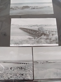
Photograph - Four copies of photographs of the Peterborough Old Bridge
... Four copies of photographs of the Peterborough Old Bridge......peterborough old bridge...Varying views of the old bridge, which was a valuable connection to the East side of the river. ...4 photocopied reproductions of different aspects of the Old bridge at Peterborough, including one which is a copy of The Rose Series Postcards No P2470....Photograph Four copies of photographs of the Peterborough Old Bridge ...Varying views of the old bridge, which was a valuable connection to the East side of the river. A view of the landscape at that time.Historic views of the town and bridge 4 photocopied reproductions of different aspects of the Old bridge at Peterborough, including one which is a copy of The Rose Series Postcards No P2470.peterborough, peterborough old bridge, curdies river bridge, rose series postcards, rose series p2470 -
 Chelsea & District Historical Society Inc
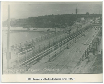
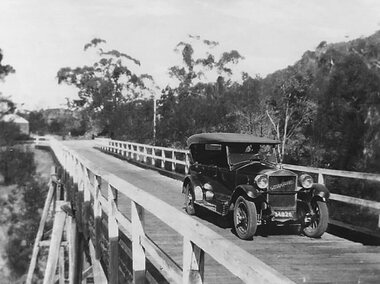
Photograph - Patterson River, Temporary and Old Bridge, c 1927
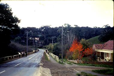
... Temporary and Old Bridge...Cars using the old bridge. Rowing boats on shore. ...Temporary and old bridge, Carrum...Cars using the old bridge. Rowing boats on shore. Temporary and Old Bridge Photograph Patterson River ...The first bridge over the river was built in the early 1880's, prior to this it was a pontoon bridge. In 1927 the construction of a concrete bridge was undertaken.Black and white photo of the old wooden road bridge (Point Nepean / Nepean Highway), and a temporary bridge over Patterson River, Carrum near the mouth of the river. Cars using the old bridge. Rowing boats on shore. Temporary and old bridge, Carrumpatterson river, road bridge, rail bridge, chelsea, transport, patterson river bridge, carrum bridge, temporary bridge, cars -
 Peterborough History Group
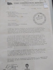
Document - Three letters pertaining to the retention of the Old Bridge
... Three letters pertaining to the retention of the Old Bridge.......curdies river bridge...old...Upon confirmation that a new bridge was to be built, there was some discussion about the possibility of retaining the old bridge for pedestrian purposes, or part of the old bridge as a fishing platform. ...Peterborough History Group Peterborough great-ocean-road Upon confirmation that a new bridge was to be built, there was some discussion about the possibility of retaining the old bridge for pedestrian purposes, or part of the old bridge as a fishing platform. ...Upon confirmation that a new bridge was to be built, there was some discussion about the possibility of retaining the old bridge for pedestrian purposes, or part of the old bridge as a fishing platform. These letters are part of the correspondence re an organisation taking responsibility for the ongoing maintenance so the old bridge could be retained.The old bridge was constructed of locally sourced timber and was such an important structure to the town when built. Its sentimental value saw locals attempt (although unsuccessfully) to retain the old bridge.Two A4 Typewritten letters, one from the Road Construction Authority to the National Trust Australia, the other from the Department of Conservation Forests & Lands to Mr John Irvine. And one hand written letter.RCA letter is stamped "Received 22 Aug 1985", Dept of Conservation Forests & Lands has a pencilled phone no inscribed.peterborough, curdies river bridge, old peterborough bridge, department of conservation forest & lands, road construction authority -
 Greensborough Historical Society
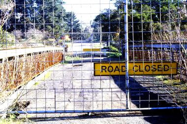
Slide - Photograph, John Ramsdale, Old bridge at Lower Plenty under reconstruction: Slide 83, 1990s
... Old bridge at Lower Plenty under reconstruction: Slide 83...old lower plenty bridge...Photograph shows a road construction area with "Road Closed" sign and temporary fencing. This is the old bridge at Lower Plenty under reconstruction....Colour photograph scanned from slide. Old bridge at Lower Plenty under reconstruction: Slide 83 Slide Photograph John Ramsdale ...Photograph shows a road construction area with "Road Closed" sign and temporary fencing. This is the old bridge at Lower Plenty under reconstruction.Part of the John Ramsdale collection of slides and audio visual material.Colour photograph scanned from slide.No maker's marks. No caption on slide.old lower plenty bridge, lower plenty bridge -
 Stawell Historical Society Inc
Photograph - Stanley Steamer of Old Delley's Bridge, Stanley Steamer on Old Delleys Bridge c1922, C 1926
... Stanley Steamer of Old Delley's Bridge...Stanley Steamer on Old Delleys Bridge c1922...Stawell Historical Society Inc 46 Longfield St Stawell grampians Transport Halls Gap 50 M North of New Curved Bridge c 1926 Stanley Steamer on Old Delleys Bridge c1922 Photograph Stanley Steamer of Old Delley's Bridge ...Transport Halls Gap50 M North of New Curved Bridge c 1926 -
 Ringwood and District Historical Society
Photograph, Wrecking of old bridge Warrandyte Road. Ringwood. Probably 1986
... Wrecking of old bridge Warrandyte Road. Ringwood. Probably 1986...Written on back of photograph, "Date ? Wrecking of old bridge Warrandyte Road."...Ringwood and District Historical Society 125A Warrandyte Road Ringwood North melbourne Written on back of photograph, "Date ? Wrecking of old bridge Warrandyte Road." Wrecking of old bridge Warrandyte Road. ...Written on back of photograph, "Date ? Wrecking of old bridge Warrandyte Road." -
 Stawell Historical Society Inc
Photograph, Old Campbells Bridge over Wimmera River
... Old Campbells Bridge over Wimmera River...Old Campbells Bridge over Wimmera River. Photo identified by Stuart McGregor Aug.2009...Old Campbells Bridge ...Old Campbells Bridge over Wimmera River. Photo identified by Stuart McGregor Aug.2009 stawell shire Old Campbells Bridge Black and white photograph of a tall bridge in a timber setting. ...Old Campbells Bridge over Wimmera River. Photo identified by Stuart McGregor Aug.2009Black and white photograph of a tall bridge in a timber setting.Old Campbells Bridge stawell shire -
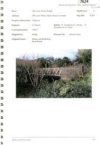
 Eltham District Historical Society Inc
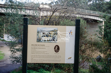
Slide - Photograph, Old Bridge, Warrandyte, Walter Withers, Heidelberg School Artists Trail, Warrandyte, c.2004
... Old Bridge, Warrandyte, Walter Withers, Heidelberg School Artists Trail, Warrandyte......old bridge...It features signs depicting paintings of artists in the location in which they were painted. heidelberg school artists trail old bridge public art walter withers warrandyte warrandyte bridge 35mm colour positive transparency Mount - white 7 dots (Technodia Italy) Old Bridge, Warrandyte, Walter Withers, Heidelberg School Artists Trail, Warrandyte Slide Photograph ...The Heidelberg School Artists' Trail extends from Heidelberg through Eltham and Warrandyte and to the Dandenongs. It features signs depicting paintings of artists in the location in which they were painted. 35mm colour positive transparency Mount - white 7 dots (Technodia Italy)heidelberg school artists trail, old bridge, public art, walter withers, warrandyte, warrandyte bridge -
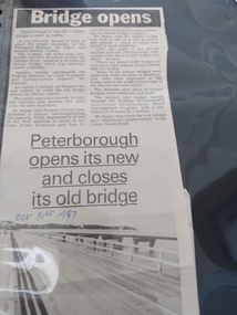 Peterborough History Group
Article - Bridge Opens in Style
... ...peterborough old bridge...Article about the opening of the New Bridge and closing of the Old Bridge....Two column article about the opening of the new bridge and closing of the old bridge...Peterborough History Group Peterborough great-ocean-road Article about the opening of the New Bridge and closing of the Old Bridge. Decribes the ceremonies and plaque dedication of the opening of the new bridge and closing of the old bridge peterborough peterborough old bridge peterborough new bridge curdies river bridge Handwritten date. ...Article about the opening of the New Bridge and closing of the Old Bridge.Decribes the ceremonies and plaque dedication of the opening of the new bridge and closing of the old bridgeTwo column article about the opening of the new bridge and closing of the old bridgeHandwritten date.peterborough, peterborough old bridge, peterborough new bridge, curdies river bridge -
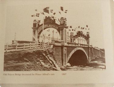 Phillip Island and District Historical Society Inc.
Photograph, 1867
... old princes bridge melbourne...Old Princes Bridge - 1845. copied from book "Melbourne's Yesterday's" See Phillip Island Book re Solomon West etc. ...Sepia photograph of the old Princes Bridge Melbourne decorated for Prince Alfred's visit in 1867...."Old Princes Bridge decorated for Prince Alfred's visit 1867"...Nov. 1983 old princes bridge melbourne prince alfred's visit 1867 w a mcleod "Old Princes Bridge decorated for Prince Alfred's visit 1867" Sepia photograph of the old Princes Bridge Melbourne decorated for Prince Alfred's visit in 1867. ...Old Princes Bridge - 1845. copied from book "Melbourne's Yesterday's" See Phillip Island Book re Solomon West etc. Nov. 1983Sepia photograph of the old Princes Bridge Melbourne decorated for Prince Alfred's visit in 1867."Old Princes Bridge decorated for Prince Alfred's visit 1867"old princes bridge melbourne, prince alfred's visit 1867, w a mcleod -
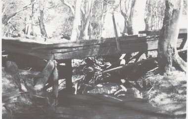 Bendigo Historical Society Inc.
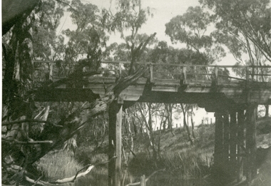
Photograph - HARRY BIGGS COLLECTION: OLD BRIDGE
... HARRY BIGGS COLLECTION: OLD BRIDGE...Photograph (proof 50A) of an old derelict wooden bridge. The bridge is spanning a small creek or possibly a portion of a river, the background is heavily timbered with red gums....Photograph HARRY BIGGS COLLECTION: OLD BRIDGE ...Photograph (proof 50A) of an old derelict wooden bridge. The bridge is spanning a small creek or possibly a portion of a river, the background is heavily timbered with red gums.bridge, wooden constructyion, derelict bridge, wooden bridge -
 Brimbank City Council
Framed Photographic Cibachrome Print, Old Bridge In Keilor
... Old Bridge In Keilor...Framed photographic cibachrome print of Old Iron Bridge over the Maribyrnong at Keilor ...Brimbank City Council 301 Hampshire Rd Sunshine melbourne Framed photographic cibachrome print of Old Iron Bridge over the Maribyrnong at Keilor Old Bridge In Keilor Framed Photographic Cibachrome Print ...Framed photographic cibachrome print of Old Iron Bridge over the Maribyrnong at Keilor -
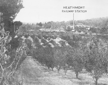 Ringwood and District Historical Society
Photograph, View of what was Heathmont township taken from about Royal Avenue looking at Mr. Herman Pump's orchard. Old bridge over Canterbury Road can be seen on left
... Herman Pump's orchard. Old bridge over Canterbury Road can be seen on left....Herman Pump's orchard. Old bridge over Canterbury Road can be seen on left."...Herman Pump's orchard. Old bridge over Canterbury Road can be seen on left." ...Typed below photograph, "View of what was Heathmont township taken from about Royal Avenue looking at Mr. Herman Pump's orchard. Old bridge over Canterbury Road can be seen on left." -
 Greensborough Historical Society
Photograph - Digital image, Old Bridge, Plenty River, 1911c
... Old Bridge, Plenty River....Photograph of old bridge over Plenty River, date unknown....Old Bridge, Plenty River. Photograph - Digital image ...Photograph of old bridge over Plenty River, date unknown.Digital copy of black and white photograph.plenty river -
 Buninyong Visitor Information Centre
Print - Engraving, The Old Bridge, Buninyong No. 24
... The Old Bridge, Buninyong No. 24...Engraving of a rough old timber bridge in Buninyong by artist and art educator, Graham Hopwood.... timber bridge in Buninyong by artist and art educator, Graham Hopwood. The Old Bridge, Buninyong No. 24 Print Engraving ...The location of the bridge has not yet been identified but further investigations will continue, as will details of when the work was completed by Graham Hopwood.A significant images of an early local structure in Buninyong. Requires further research.Engraving of a rough old timber bridge in Buninyong by artist and art educator, Graham Hopwood.Hand written on the backing paper of the frame: 'Originally owned by JM Matheson, given to Marjorie Matheson, 1956, Olympic Games'.graham hopwood, bridges, engravings, topographical art, buninyong -
 Greensborough Historical Society
Photograph - Photograph (Copy), Anne Paul, Old bridge, Lower Plenty 2003, 2003_12
... Old bridge, Lower Plenty 2003...Two views of the old bridge over the Plenty River in Lower Plenty....Greensborough Historical Society 34A Glenauburn Road Lower Plenty Lower Plenty melbourne Two views of the old bridge over the Plenty River in Lower Plenty. lower plenty plenty river floods edward willis drive lower plenty 2 colour photographs printed on paper, handwritten captions Old bridge, Lower Plenty 2003 Photograph Photograph (Copy) Anne Paul ...Two views of the old bridge over the Plenty River in Lower Plenty.2 colour photographs printed on paper, handwritten captionslower plenty, plenty river, floods, edward willis drive lower plenty -
 Ballarat Heritage Services
Painting, Clare Gervasoni, Old Bridge over the Woady Yallock River, 26/03/2023
... Old Bridge over the Woady Yallock River ...Colour photographs of an old timber topped bridge crossing the Woady Yalloak River on Golden Lake Road. ...The bridge has bluestone foundations. Old Bridge over the Woady Yallock River Painting Clare Gervasoni ...Colour photographs of an old timber topped bridge crossing the Woady Yalloak River on Golden Lake Road. The bridge has bluestone foundations. bridge, woady yallock river, golden lake road, bluestone -
 Phillip Island and District Historical Society Inc.
Photograph
... Black & White Photograph of Old Bridge from Newhaven....Looking toward Old Bridge from Newhaven. 1-12-1969...Jack Jenner (1977) local history photography photographs slides film view from newhaven black & white photograph jack jenner bridges newhaven san remo Looking toward Old Bridge from Newhaven. 1-12-1969 Black & White Photograph of Old Bridge from Newhaven. ...Part of collection of Photographs donated to the Museum by the family of the late Mr. Jack Jenner (1977)Black & White Photograph of Old Bridge from Newhaven.Looking toward Old Bridge from Newhaven. 1-12-1969local history, photography, photographs, slides, film, view from newhaven, black & white photograph, jack jenner, bridges, newhaven, san remo -
 Glenelg Shire Council Cultural Collection
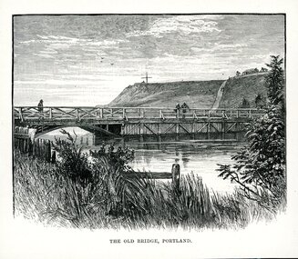
Artwork, other - Illustration, THE OLD BRIDGE, PORTLAND, n.d
... THE OLD BRIDGE, PORTLAND....Underneath is written THE OLD BRIDGE, PORTLAND....Underneath is written THE OLD BRIDGE, PORTLAND. THE OLD BRIDGE, PORTLAND. ...Illustration. Taken and cut from a book. View of bridge across Salt Creek. Bridge has the appearance of being timber and features to the left of the bridge a half arch opening through to the other side of the creek. 3 people are on the bridge. Fore ground has part of a fence visible through long grass and some shrubbery. Observatory Hill in background with a large cross structure on the top to the left. A road or path is visible up the side of the hill towards a dwelling with a panel fence and trees. Two people are on the path and what appears to be 3 sheep to the left of them grazing on the hill. Sky appears cloudy with 3 birds flying. Underneath is written THE OLD BRIDGE, PORTLAND.portland victoria -
Winchelsea and District Historical Society
Photograph, Old wooden bridge and New Bluestone Bridge circa 1867
... Old wooden bridge and New Bluestone Bridge circa 1867...Very early Winchelsea circa 1867/8.photo taken from opposite old Library. Early wooden bridge right foreground and present bluestone bridge centre foreground. ...Old wooden Bridge and New Bluestone Bridge circa 1867. ...Bridge Dr. Meyler Stirling's Store first Shire Hall wooden. Old wooden Bridge and New Bluestone Bridge circa 1867. ...photograph taken circa 1867/8 Original wooden bridge built about 1857Photo of Blue stone bridge, as is today This photo is important, shows Winchelsea before many buildings.Very early Winchelsea circa 1867/8.photo taken from opposite old Library. Early wooden bridge right foreground and present bluestone bridge centre foreground. First Shire Hall and Dr. Meyler,s residence right above wooden bridge. On the left is Stirling's StoreOld wooden Bridge and New Bluestone Bridge circa 1867. Winchelsea Shire Hall top right (First Shire Hall).bridge, dr. meyler, stirling's store, first shire hall, wooden. -
 Greensborough Historical Society
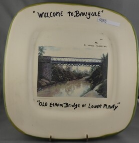
Plate, Serge Daeffler, Old Eltham Bridge at Lower Plenty, 1980s
... Old Eltham Bridge at Lower Plenty...Hand painted text with transfer illustration of the Old Eltham Bridge at Lower Plenty which was opened on 8/3/1867...."Welcome to Banyule", "Old Etham (sic) Bridge at Lower Plenty", by Serge Daeffler. ...Hand painted text with transfer illustration of the Old Eltham Bridge at Lower Plenty which was opened on 8/3/1867. plates lower plenty "Welcome to Banyule", "Old Etham (sic) Bridge at Lower Plenty", by Serge Daeffler. ...Ceramic plate, decorated by Serge Daeffler. Hand painted text with transfer illustration of the Old Eltham Bridge at Lower Plenty which was opened on 8/3/1867.Ceramic plate, off-white with green edges, colour transfer photograph, glazed"Welcome to Banyule", "Old Etham (sic) Bridge at Lower Plenty", by Serge Daeffler. Card of Banyule's Heidelberg School Heritage Artist, Robert S, Phillips attached to rear, with price label from Savers.plates, lower plenty -
 Brimbank City Council
Framed Cibachrome Photographic Print, Old iron Bridge in Keilor
... Old iron Bridge in Keilor...Framed photographic cibachrome print of Old Iron Bridge over the Maribyrnong at Keilor...Brimbank City Council 301 Hampshire Rd Sunshine melbourne Framed photographic cibachrome print of Old Iron Bridge over the Maribyrnong at Keilor Old iron Bridge in Keilor Framed Cibachrome Photographic Print ...Framed photographic cibachrome print of Old Iron Bridge over the Maribyrnong at Keilor -
 Ringwood and District Historical Society
Photograph, The old Warrandyte Road bridge viewed across bypass. Ringwood, 1986
... The old Warrandyte Road bridge viewed across bypass. Ringwood, 1986...Written on back of photograph, "29.11.86. The old bridge viewed across bypass." (Warrandyte Road bridge)...Ringwood and District Historical Society 125A Warrandyte Road Ringwood North melbourne Written on back of photograph, "29.11.86. The old bridge viewed across bypass." (Warrandyte Road bridge) The old Warrandyte Road bridge viewed across bypass. ...Written on back of photograph, "29.11.86. The old bridge viewed across bypass." (Warrandyte Road bridge) -
 Greensborough Historical Society
Document - Document Collection, Allom Lovell & Associates, Old Lower Plenty Bridge, 2001
... Old Lower Plenty Bridge......old lower plenty bridge...Heritage citation for the Old Lower Plenty Bridge, copied from Banyule Heritage Places Study; a short history of the bridge and a news clipping, dated 2001 reporting on the re-opening of the bridge as a link in the Plenty River Trail....Greensborough Historical Society 34A Glenauburn Road Lower Plenty Lower Plenty melbourne Heritage citation for the Old Lower Plenty Bridge, copied from Banyule Heritage Places Study; a short history of the bridge and a news clipping, dated 2001 reporting on the re-opening of the bridge as a link in the Plenty River Trail. plenty river plenty river trail old lower plenty bridge lower plenty 4 p., illus. ...Heritage citation for the Old Lower Plenty Bridge, copied from Banyule Heritage Places Study; a short history of the bridge and a news clipping, dated 2001 reporting on the re-opening of the bridge as a link in the Plenty River Trail.4 p., illus. Heritage citation, 2p.; history of bridge, 1p.; newspaper clipping, 1p. plenty river, plenty river trail, old lower plenty bridge, lower plenty -
 Greensborough Historical Society
Slide, Fred Harris, Main Street, old river bridge Greensborough, 1949c
... Main Street, old river bridge Greensborough...Taken about 1949, this colour slide shows Main Street Greensborough crossing the Plenty River via the 'old' bridge....Main Street, old river bridge Greensborough Slide Slide Fred Harris ...Taken about 1949, this colour slide shows Main Street Greensborough crossing the Plenty River via the 'old' bridge.1 photographic slide in yellow Kodak packet.Name of donor and title of slide written on outside of packetmain street greensborough, plenty river, main street bridge -
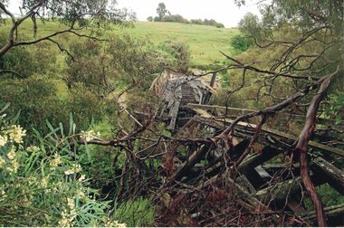 Linton and District Historical Society Inc
Photograph, Dilapidated bridge over Springdallah Creek, Happy Valley/Piggoreet, 2010
... ...Old Springdallah Bridge...In 2025, little remains of the old bridge....Colour photograph showing damage to the Old Springdallah Bridge - a trestle bridge spanning Springdallah Creek, on Linton-Piggoreet Road. ...In 2025, little remains of the old bridge. Trestle Bridges Old Springdallah Bridge Colour photograph showing damage to the Old Springdallah Bridge - a trestle bridge spanning Springdallah Creek, on Linton-Piggoreet Road. ...Already in a dilapidated condition, the bridge was further damaged by storms and floodwaters in 2010 and 2011. In 2025, little remains of the old bridge.Colour photograph showing damage to the Old Springdallah Bridge - a trestle bridge spanning Springdallah Creek, on Linton-Piggoreet Road. trestle bridges, old springdallah bridge -
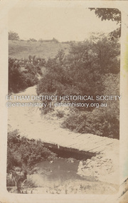 Eltham District Historical Society Inc
Postcard - Photograph postcard, Old Bridge, Kaylock's Crossing, Brougham Street, Eltham, c.1912
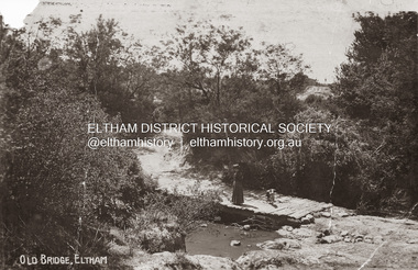
... Old Bridge, Kaylock's Crossing, Brougham Street, Eltham...Kaylock's Bridge formed part of the original coach road to Eltham and in 1922 was described as an "old rustic bridge". ...Kaylock's Bridge formed part of the original coach road to Eltham and in 1922 was described as an "old rustic bridge". ...Date estimated to be circa 1912 based on the style of printing on the reverse of the card - Kodak Austral paper for real photo postcards, the paper was manufactured c.1908-1914 (See also POSTCARDS ON KODAK PAPER - IS IT POSSIBLE TO "DATE" THEM? http://tps.org.au/bb/viewtopic.php?t=115) Brougham Street was created in Josiah Holloway's 1851 subdivision of Little Eltham. It was one of several east-west streets shown on the subdivision plan as crossing the Diamond Creek. The western part was named Wellington Street on the subdivision plan but was later changed to conform with the name of the eastern part as acknowledgement of the continuity of the street. It is not known when the first bridge was constructed in Brougham Street however it was certainly mentioned at Council’s meeting of 2 June 1884 as being in a dangerous state of repair. This photo (c.1895) of an old bridge shows a very low-level simple log girder bridge crossing the creek at a right angle and so the approaches involved bends in the road alignment. This bridge was generally known as Kaylocks Bridge or Kaylock’s Crossing after the owner of the adjoining land. It was most likely built from around the mid-1850s, or a crossing of some fashion established as Richard George Kaylock, butcher of Little Eltham and his wife Emily Ann settled there in 1854. His property was in Wellington Street (now Brougham Street) and apparently extended across the Diamond Creek. The land on the western side of the creek was farmed, the house being on the eastern side. Kaylock's Bridge formed part of the original coach road to Eltham and in 1922 was described as an "old rustic bridge". Its low level and insubstantial construction made it susceptible to flood damage, necessitating frequent closures until repairs could be carried out. In September 1922, Council called for tenders for a new timber bridge to be constructed at Kaylock’s crossing. An engineering assessment carried out for the Council by Macleod Consulting at the time of the replacement suggested that the construction details indicate that it was in the 1900s, however this dating could possibly have been the result of numerous repairs undertaken over the years to flood damage. The tender was awarded to Mr Weller of Kangaroo Ground who commenced work in February 1923 on a higher-level timber trestle bridge. Work was slowed due to illness of the contractor and the accidental death of a man in March 1923 following the collapse of the bank after he had jumped into a hole that had just been blasted. The bridge was completed around July 1923 at which point the old structure was pulled up, marking what was described in the ‘Advertiser’ newspaper as the passing of an old and well-loved landmark in the district. In April 1924 the approach to Kaylocks bridge was washed away during the heavy flooding that destroyed the Main Road bridge. The western side was repaired, and an extra span was added to the eastern side using timber from the destroyed Main Road bridge. The bridge was again severely damaged four months later in August 1924 When a lack of finances delayed repairs to the Bridge Street bridge in 1931 (also referred to as Obelisk Bridge at the time), traffic had to detour via Brougham Street for some time. Local residents feared that the Bridge Street bridge might never reopen. Kaylocks Bridge was constantly subject to damage by floods. In the 1934 flood it was submerged by two feet of water. In more recent times the bridge was again severely damaged by flooding and repairs made. A new bridge and adjoining footbridge were constructed in 2009.Digital file only Postcards scanned from the collection of Michael Aitken on loan to EDHS, 2 Sep. 2022michael aitken collection, eltham, postcards, bridge, brougham street, diamond creek (creek), kaylocks bridge, wellington street -
 Eltham District Historical Society Inc
Photograph, Old Bridge, Kaylock's Crossing, Brougham Street, Eltham, c.1895
... Old Bridge, Kaylock's Crossing, Brougham Street, Eltham...Kaylock's Bridge formed part of the original coach road to Eltham and in 1922 was described as an "old rustic bridge". ...Kaylock's Bridge formed part of the original coach road to Eltham and in 1922 was described as an "old rustic bridge". ...Brougham Street was created in Josiah Holloway's 1851 subdivision of Little Eltham. It was one of several east-west streets shown on the subdivision plan as crossing the Diamond Creek. The western part was named Wellington Street on the subdivision plan but was later changed to conform with the name of the eastern part as acknowledgement of the continuity of the street. It is not known when the first bridge was constructed in Brougham Street however it was certainly mentioned at Council’s meeting of 2 June 1884 as being in a dangerous state of repair. This photo (c.1895) of an old bridge shows a very low-level simple log girder bridge crossing the creek at a right angle and so the approaches involved bends in the road alignment. This bridge was generally known as Kaylocks Bridge or Kaylock’s Crossing after the owner of the adjoining land. It was most likely built from around the mid-1850s, or a crossing of some fashion established as Richard George Kaylock, butcher of Little Eltham and his wife Emily Ann settled there in 1854. His property was in Wellington Street (now Brougham Street) and apparently extended across the Diamond Creek. The land on the western side of the creek was farmed, the house being on the eastern side. Kaylock's Bridge formed part of the original coach road to Eltham and in 1922 was described as an "old rustic bridge". Its low level and insubstantial construction made it susceptible to flood damage, necessitating frequent closures until repairs could be carried out. In September 1922, Council called for tenders for a new timber bridge to be constructed at Kaylock’s crossing. An engineering assessment carried out for the Council by Macleod Consulting at the time of the replacement suggested that the construction details indicate that it was in the 1900s, however this dating could possibly have been the result of numerous repairs undertaken over the years to flood damage. The tender was awarded to Mr Weller of Kangaroo Ground who commenced work in February 1923 on a higher-level timber trestle bridge. Work was slowed due to illness of the contractor and the accidental death of a man in March 1923 following the collapse of the bank after he had jumped into a hole that had just been blasted. The bridge was completed around July 1923 at which point the old structure was pulled up, marking what was described in the ‘Advertiser’ newspaper as the passing of an old and well-loved landmark in the district. In April 1924 the approach to Kaylocks bridge was washed away during the heavy flooding that destroyed the Main Road bridge. The western side was repaired, and an extra span was added to the eastern side using timber from the destroyed Main Road bridge. The bridge was again severely damaged four months later in August 1924 When a lack of finances delayed repairs to the Bridge Street bridge in 1931 (also referred to as Obelisk Bridge at the time), traffic had to detour via Brougham Street for some time. Local residents feared that the Bridge Street bridge might never reopen. Kaylocks Bridge was constantly subject to damage by floods. In the 1934 flood it was submerged by two feet of water. In more recent times the bridge was again severely damaged by flooding and repairs made. A new bridge and adjoining footbridge were constructed in 2009. Part of a slide show presentation "Bridges & Waterways of the Shire" by Russell Yeoman to the 13 September 1989 Society meeting. The presentation included slides of historic photos from the Shire of Eltham Pioneers collections as well as several recent views.Photo of earliest known crossing of the Diamond Creek at brougham StreetPostcard photo printbrougham street, eltham, wellington street, kaylocks bridge, bridge, diamond creek (creek) -
 Lakes Entrance Historical Society
Photograph - Bridges, Fish Marie, old highway bridge over Toorloo Arm Vicoria, 1980
... old highway bridge over Toorloo Arm Vicoria...Colour photograph showing the old highway bridge over Toorloo Arm near Lakes Entrance, dense forest surrounds. ...Bridges Colour photograph showing the old highway bridge over Toorloo Arm near Lakes Entrance, dense forest surrounds. ...Second photograph 10 x 12 cm, taken before the bridge was demolished.Colour photograph showing the old highway bridge over Toorloo Arm near Lakes Entrance, dense forest surrounds. Toorloo Arm Victoria, .bridges -
 Stawell Historical Society Inc
Photograph, Old wooden Bridge over Dog Trap Creek in Callawadda
... Old wooden Bridge over Dog Trap Creek in Callawadda...Old wooden Bridge over Dog Trap Creek - Callawadda...Stawell Historical Society Inc 46 Longfield St Stawell grampians Old wooden Bridge over Dog Trap Creek - Callawadda Stawell Old wooden Bridge over Dog Trap Creek in Callawadda Photograph ...Old wooden Bridge over Dog Trap Creek - Callawaddastawell