Showing 617 items matching "old maps"
-
 Peterborough History Group
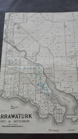
Map - Map of Curdies River Inlet district, Narrawaturk
... ...old maps...Photocopy of an old map...Photocopy of an old map Narrawaturk Map Map of Curdies River Inlet district ...Shows the allotment boundaries and names of landowners at the timeSignificant as it shows owners of rural land in the Peterborough area.Photocopy of an old mapHandwritten notes and markings on the map.peterborough, curdies river, curdies river inlet, old maps, maps, narrawaturk -
 Whitehorse Historical Society Inc.
Book, Sevenoaks Park, 1980 repr. 2004
... Contains old maps and land titles...A history of Jeffery Street Blackburn and surrounding area once known as Sevenoaks Park. Contains old maps and land titles...A history of Jeffery Street Blackburn and surrounding area once known as Sevenoaks Park. Contains old maps and land titles Sevenoaks Park Book Book ...A history of Jeffery Street Blackburn and surrounding area once known as Sevenoaks Park.A history of Jeffery Street Blackburn and surrounding area once known as Sevenoaks Park. Contains old maps and land titlesA history of Jeffery Street Blackburn and surrounding area once known as Sevenoaks Park. sevenoaks park, jeffery, mary ann, jeffery street blackburn, blackburn road blackburn, lake road blackburn, da costa, robin, burns, frank, satchwell, keith -
Glenelg Shire Council Cultural Collection
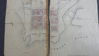
Plan - Town Plan - Cape Bridgewater, 02/04/1992
... Front: 'OLD MAP' handwritten, top edge...Glenelg Shire Council Cultural Collection History House Cliff Street Portland great-ocean-road plan town planning Cape Bridgewater Front: 'OLD MAP' handwritten, top edge Black and white photocopy of an old plan of a subdivision at Cape Bridgewater. ...Black and white photocopy of an old plan of a subdivision at Cape Bridgewater. Two halves joined together with sellotape. Black texta numbers on some of the lots 1 - 28Front: 'OLD MAP' handwritten, top edgeplan, town planning, cape bridgewater -
 Queenscliffe Maritime Museum
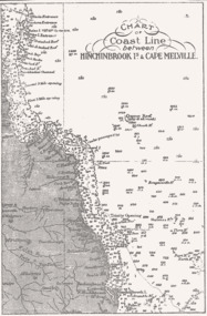
Map - B & W coastal map of Hinchinbrook Island to Cape Melville in Queensland, Coastal map Queensland Hinchinbrook Is to Cape Melville, Before donation in 1987
... old maps of Australian coast...Queenscliffe Maritime Museum 2 Wharf St Queenscliff geelong-and-the-bellarine-peninsula Australian coastal maps Australian coastal maps old maps of Australian coast Reverse " NIL " Map from unknown book of Queensland coast Hinchinbrook Island to Cape Melville, pre 1987 Coastal map Queensland Hinchinbrook Is to Cape Melville Map B & W coastal map of Hinchinbrook Island to Cape Melville in Queensland ...Australian coastal mapsAustralian coastal mapsMap from unknown book of Queensland coast Hinchinbrook Island to Cape Melville, pre 1987Reverse " NIL "old maps of australian coast -
 Queenscliffe Maritime Museum
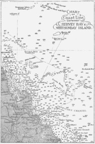
Map - B & W coastal map between Hervey Bay & Whitsunday Island, in Queensland, Coastal map, Queensland, between Whitsunday Island & Hervey Bay, Before donation in 1987
... old maps of Australian coast...Queenscliffe Maritime Museum 2 Wharf St Queenscliff geelong-and-the-bellarine-peninsula Australian coastal maps Australian coastal maps old maps of Australian coast Reverse " NIL " Coastal 'soundings' map between Hervey Bay & Whitsunday Island, in Queensland, from an unknown book, pre-1987 Coastal map, Queensland, between Whitsunday Island & Hervey Bay. ...Australian coastal mapsAustralian coastal mapsCoastal 'soundings' map between Hervey Bay & Whitsunday Island, in Queensland, from an unknown book, pre-1987Reverse " NIL "old maps of australian coast -
 Queenscliffe Maritime Museum
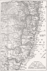
Map - B & W coastal map between Sydney & Brisbane, Australia, Coastal map, Queensland, between Whitsunday Island & Hervey Bay, Before donation in 1987
... old maps of Australian coast...Queenscliffe Maritime Museum 2 Wharf St Queenscliff geelong-and-the-bellarine-peninsula Australian coastal maps Australian coastal maps old maps of Australian coast Reverse " NIL " Coastal 'soundings' map between Sydney & Brisbane, from an unknown book, pre-1987. ...Australian coastal mapsAustralian coastal mapsCoastal 'soundings' map between Sydney & Brisbane, from an unknown book, pre-1987.Reverse " NIL "old maps of australian coast -
 Queenscliffe Maritime Museum
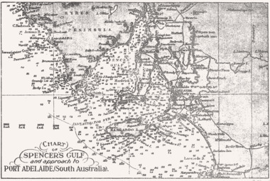
Map - B & W coastal map Spencer's Gulf & into Port Adelaide, South Australia, Coastal map of Port Adelaide South Australia showing Spencer's Gulf, Before donation in 1987
... old maps of Australian coast...Queenscliffe Maritime Museum 2 Wharf St Queenscliff geelong-and-the-bellarine-peninsula Australian coastal maps Australian coastal maps old maps of Australian coast Reverse " NIL " B&W coastal 'soundings' map Spencer's Gulf & into Port Adelaide, South Australia., from an unknown book, pre-1987. ...Australian coastal mapsAustralian coastal mapsB&W coastal 'soundings' map Spencer's Gulf & into Port Adelaide, South Australia., from an unknown book, pre-1987.Reverse " NIL "old maps of australian coast -
 Queenscliffe Maritime Museum
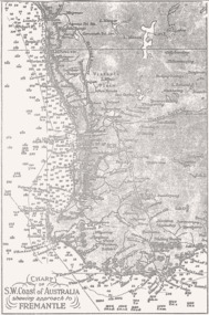
Map - B & W coastal map, Fremantle & SW Coast, Western Australia, Coastal map of SW Coast of Australia & the approach to Fremantle WA, Before donation in 1987
... old maps of Australian coast...Queenscliffe Maritime Museum 2 Wharf St Queenscliff geelong-and-the-bellarine-peninsula Australian coastal maps Australian coastal maps old maps of Australian coast Reverse " NIL " B&W Coastal map of SW Coast of Australia & the approach to Fremantle WA, from an unknown book, c1864. ...Australian coastal mapsAustralian coastal mapsB&W Coastal map of SW Coast of Australia & the approach to Fremantle WA, from an unknown book, c1864.Reverse " NIL "old maps of australian coast -
 Peterborough History Group
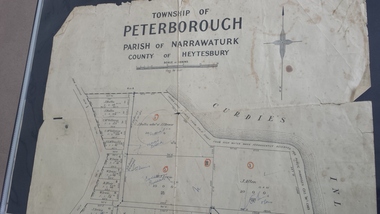
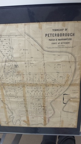
Map - Map of the town, Government Printer, Township of Peterborough
... ...old maps...Significant as it shows the names of the owners of each allotment in 1931 and handwritten notes of more recent owners. peterborough old maps maps Handwritten landowner names over the original printed names. 27/6/1931 paper map of the township of Peterborough including names of the landowners at that time. ...Map donated by Barry Jenkins and assume that updated names were written on the map by him. Good information pertaining to the history of each allotment. Significant as it shows the names of the owners of each allotment in 1931 and handwritten notes of more recent owners.27/6/1931 paper map of the township of Peterborough including names of the landowners at that time.Handwritten landowner names over the original printed names.peterborough, old maps, maps -
 Peterborough History Group
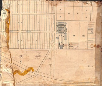
Map - Map of the township of Peterborough, Township of Peterborough
... ...old maps...Hand drawn arrows show the road now built connecting Macs St to the Warrnambool Rd Shows early layout of the town and names of landowners peterborough old maps maps some hand drawn arrows. government map of the township of Peterborough with handwritten notes on it. ...Same map as 4012 but printed names are easier to read. Hand drawn arrows show the road now built connecting Macs St to the Warrnambool RdShows early layout of the town and names of landownersgovernment map of the township of Peterborough with handwritten notes on it. Includes the names of the landowners 1931some hand drawn arrows.peterborough, old maps, maps -
 Peterborough History Group
Map - Map of the township of Peterborough, Township of Peterborough
... ...old maps...Peterborough History Group Peterborough great-ocean-road Undated but indicative of the layout of the town. includes printed notes regarding the landscape and flora. Old map of the township of Peterborough from J S Irvine. peterborough old maps Handwritten on the rear is J.S Irvine A3 size paper map with tape around the sides. ...Undated but indicative of the layout of the town. includes printed notes regarding the landscape and flora.Old map of the township of Peterborough from J S Irvine.A3 size paper map with tape around the sides. Includes handwritten notes.Handwritten on the rear is J.S Irvinepeterborough, old maps -
 Peterborough History Group
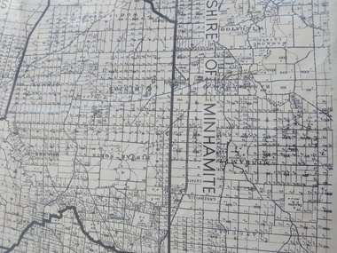
Map - Shire of Warrnambool East Riding
... ...old maps...Historic information peterborough curdies river inlet old maps warrnambool shire map Irvine written in pencil on the back A3 size map of the Warrnambool Shire East Riding, includes landscape details, and the location of town in the Shire. ...Contextual location of Peterborough town within the shire at that time, including local roads.Historic informationA3 size map of the Warrnambool Shire East Riding, includes landscape details, and the location of town in the Shire.Irvine written in pencil on the backpeterborough, curdies river inlet, old maps, warrnambool shire map -
 Peterborough History Group
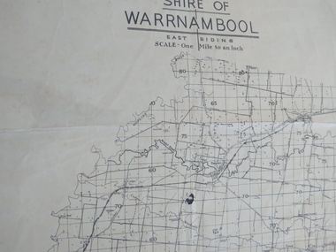
Map - Shire of Warrnambool
... ...old maps...Peterborough History Group Peterborough great-ocean-road Map of the area, when Peterborough was part of Warrnambool Shire Historic map of the area when Peterborough was in the Warrnambool Shire peterborough warrnambool shire old maps A3 size map, larger view of the whole shire of Warrnambool, and includes adjoining Shire Boundaries. ...Map of the area, when Peterborough was part of Warrnambool ShireHistoric map of the area when Peterborough was in the Warrnambool ShireA3 size map, larger view of the whole shire of Warrnambool, and includes adjoining Shire Boundaries. Shows individual land allotments.peterborough, warrnambool shire, old maps -
 Brimbank City Council
2 x Black Folios
... Old parish maps and photographs in two black folios....Brimbank City Council 301 Hampshire Rd Sunshine melbourne Old parish maps and photographs in two black folios. 2 x Black Folios 2 x Black Folios ...Old parish maps and photographs in two black folios. -
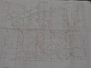 Running Rabbits Military Museum operated by the Upwey Belgrave RSL Sub Branch
Field Map
... Very old, fragile map of Becelaere, Western Front, France....Running Rabbits Military Museum operated by the Upwey Belgrave RSL Sub Branch 1 Mast Gully Road Upwey melbourne Documents WW1 Army Very old, fragile map of Becelaere, Western Front, France. ...Very old, fragile map of Becelaere, Western Front, France.documents, ww1, army -
Clunes Museum
Document - FOLDER
... FOLDER OF OLD SHIRE MAPS AND DOCUMENTS TALBOT AND CLUNES SHIRE, ETC, ETC....Clunes Museum 36 Fraser Street enter building through Collins Place Clunes goldfields LOCAL HISTORY FOLDER SHIRE OF TALBOT AND CLUNES FOLDER OF OLD SHIRE MAPS AND DOCUMENTS TALBOT AND CLUNES SHIRE, ETC, ETC. ...FOLDER OF OLD SHIRE MAPS AND DOCUMENTS TALBOT AND CLUNES SHIRE, ETC, ETC.local history, folder, shire of talbot and clunes -
 Dandenong/Cranbourne RSL Sub Branch
Document - Framed Information Sheet, About The Map, Circa 2000s
... The map was produced using a number of older railway maps, including the Escritt translated map and a local Thai road touring map....The map was produced using a number of older railway maps, including the Escritt translated map and a local Thai road touring map. ...The information sheet belongs with a map showing the Burma Thailand Railway and it's route with the various camps and P.O.W centres. The map was produced over a period of 15 months and drawn in four stages. Shows Hellfire Pass formerly ( The Konyu Cutting). The 50 Kilo Camp in Burma. There were 56 stations and 87 camps on the route of the map. The map gives due credibility and was released as a limited edition of 1000 copies only. Copies of the map are displayed all over the world including Staffordshire in England, University of Houston, National Guard Museum of Texas and on display at the Australian and New Zealand Embassies in Bangkok.Framed information sheet of the map produced to show the various camps and sights along the Burma Thailand railway. The map was produced using a number of older railway maps, including the Escritt translated map and a local Thai road touring map. -
 Sunshine and District Historical Society Incorporated
Plan - Albion (Old) being Subdivided Sections XVIII and XIX Parish of Cut Paw Paw 1879 Map
... Albion (Old) being Subdivided Sections XVIII and XIX Parish of Cut Paw Paw 1879 Map...Very old cloth map of Albion (Old) being Subdivided Sections XVIII and XIX Parish of Cut Paw Paw 1879 Map...Albion (Old) being Subdivided Sections XVIII and XIX Parish of Cut Paw Paw 1879 Map...Albion Albion (Old) being Subdivided Sections XVIII and XIX Parish of Cut Paw Paw 1879 Map Very old cloth map of Albion (Old) being Subdivided Sections XVIII and XIX Parish of Cut Paw Paw 1879 Map Plan Albion (Old) being Subdivided Sections XVIII and XIX Parish of Cut Paw Paw 1879 Map ...Albion (Old) being Subdivided Sections XVIII and XIX Parish of Cut Paw Paw 1879 Mapalbion -
 Bendigo Historical Society Inc.
Map - BENDIGO (PART), No date visible
... Parish plan. Older unidentifiable map on the reverse side....History House 11 Mackenzie Street Bendigo goldfields MAP Bendigo city streets Bendigo City Streets Sandhurst City Streets Map:Part of Sandhurst City streets, showing west side of High St. between Ophir St. and View Place. Parish plan. Older ...Map:Part of Sandhurst City streets, showing west side of High St. between Ophir St. and View Place. Parish plan. Older unidentifiable map on the reverse side.map, bendigo, city streets, bendigo city streets, sandhurst city streets -
 Sunshine and District Historical Society Incorporated
Map - Sunshine Map showing lots between Darnley Street in the East & Anderson Road in the West and between Hertford Road in the North and Wright Street in the South
... Very old cloth map of Sunshine showing lots between Darnley Street in the East & Anderson Road in the West and between Hertford Road in the North and Wright Street in the South...Sunshine Map Danks & Son|Braybrook Implement Company|Braybrook Juntion Station Very old cloth map of Sunshine showing lots between Darnley Street in the East & Anderson Road in the West and between Hertford Road in the North and Wright Street in the South Map Sunshine Map showing lots between Darnley Street in the East & Anderson Road in the West and between Hertford Road in the North and Wright Street in the South ...Danks & Son|Braybrook Implement Company|Braybrook Juntion Stationsunshine, map -
Stawell Historical Society Inc
Map, Stawell Gold Mines, Plan View of Township Area Showing Known Old Workings. 2003, 13/06/2003
... Two AO Maps that Overlap Showing Old workings on Map of Town North of Patrick Street...Stawell Historical Society Inc 46 Longfield St Stawell grampians Scale 1 : 5000 Two AO Maps that Overlap Showing Old workings on Map of Town North of Patrick Street Plan View of Township Area Showing Known Old Workings. 2003 Map Stawell Gold Mines ...Two AO Maps that Overlap Showing Old workings on Map of Town North of Patrick StreetScale 1 : 5000 -
 Robin Boyd Foundation
Document - Script, Robin Boyd, The Flying Dogtor. Episode 40 Mystery Solved, 1963
... The Flying Dogtor and the bush children followed clues on an old map they found which led them to the place where a bushranger had buried treasure 100 years ago. ...Robin Boyd Foundation 290 Walsh Street South Yarra melbourne The Flying Dogtor and the bush children followed clues on an old map they found which led them to the place where a bushranger had buried treasure 100 years ago. ...The Flying Dogtor and the bush children followed clues on an old map they found which led them to the place where a bushranger had buried treasure 100 years ago. Crafty Carson Carpetbag and Old Man Redback stole the map, and followed the same clues to the same spot. Crafty started digging immediately but Wilbur Wombat, who was doing the digging for the Dogtor's party, wanted to wait until night. He was the sort of animal who worked better at night, explained The Flying Dogtor.The Flying Dogtor" series was broadcast on Australian Television Network (later becoming the Seven Network) between February and April 1964 (see item D254 for schedule).Typewritten, carbon copy, foolscap, 2 pagesPage 1 & 2: minor handwritten editsthe flying dogtor, robin boyd, crawford productions, manuscript -
 Bendigo Historical Society Inc.
Document - OLD TOM LEASE MAP
... OLD TOM LEASE MAP...Hand Drawn map of Old Tom Lease - Parish of Huntly, County of Bendigo, Mining district of Sandhurst....Document OLD TOM LEASE MAP ...Hand Drawn map of Old Tom Lease - Parish of Huntly, County of Bendigo, Mining district of Sandhurst.place, land, mining -
 Vision Australia
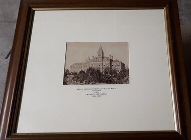
Photograph - Image, Charles Nettleton, Blind Asylum School, St Kilda Road, circa 1875
... Blind Asylum School, St Kilda Road Victoria c. 1875 Charles Nettleton 1826-1902 Spencer Scott Sandilands 546 High Street, East Preson, 3181 Melbourne, Victoria, Australia, Tel: (03) 529 8011 Fax: (03) 521 1754 33 George Street, The Rocks, 2000 Sydney, New South Wales, Australia, Tel: (02) 241 4251 Fax: (02) 2414535 Rare Prints, Antiquarian Books, Old Maps, Australiana, Antiques, Photographs, Framing c.1875 Charles Nettleton School from the Blind Original Photograph $65 Guaranteed over 100 years old...Royal Victorian Institute for the Blind Buildings Blind Asylum School, St Kilda Road Victoria c. 1875 Charles Nettleton 1826-1902 Spencer Scott Sandilands 546 High Street, East Preson, 3181 Melbourne, Victoria, Australia, Tel: (03) 529 8011 Fax: (03) 521 1754 33 George Street, The Rocks, 2000 Sydney, New South Wales, Australia, Tel: (02) 241 4251 Fax: (02) 2414535 Rare Prints, Antiquarian Books, Old Maps, Australiana, Antiques, Photographs, Framing c.1875 Charles Nettleton School from the Blind Original Photograph $65 Guaranteed over 100 years old 2 black and white images of the Guiding Light at Elanora Blind Asylum School, St Kilda Road Photograph Image Charles Nettleton ...Unsubstantiated photograph of the Asylum for the Blind in 1875. The four storey bluestone building rises above a group of trees planted in the garden. A picket and wire/string fence border the unpaved circular driveway. 2 black and white images of the Guiding Light at Elanora Blind Asylum School, St Kilda Road Victoria c. 1875 Charles Nettleton 1826-1902 Spencer Scott Sandilands 546 High Street, East Preson, 3181 Melbourne, Victoria, Australia, Tel: (03) 529 8011 Fax: (03) 521 1754 33 George Street, The Rocks, 2000 Sydney, New South Wales, Australia, Tel: (02) 241 4251 Fax: (02) 2414535 Rare Prints, Antiquarian Books, Old Maps, Australiana, Antiques, Photographs, Framing c.1875 Charles Nettleton School from the Blind Original Photograph $65 Guaranteed over 100 years oldroyal victorian institute for the blind, buildings -
 Bendigo Historical Society Inc.
Map - OLD TOM MINE, WHIPSTICK
... ...old tom lease map...2 copies ( A4 and A3) of Old Tom lease. Map shows Old Tom Reef, old working open cutting, shaft 150 ft., Easter Reef, dam sand heap, water race, 3 other shafts, 120ft., 90ft., and 500 ft. marked on map. ...History House 11 Mackenzie Street Bendigo goldfields BENDIGO Mining old tom lease map 2 copies ( A4 and A3) of Old Tom lease. ...2 copies ( A4 and A3) of Old Tom lease. Map shows Old Tom Reef, old working open cutting, shaft 150 ft., Easter Reef, dam sand heap, water race, 3 other shafts, 120ft., 90ft., and 500 ft. marked on map. Stamped on map '64.3.34' Written on bottom of map in handwriting ' Old Tom Lease, Parish of Huntly, County of Bendigo, Mining district of Sandhurst'bendigo, mining, old tom lease map -
 Bendigo Military Museum
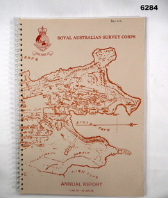
Booklet - Royal Australian Survey Corps - Annual Report 1 Jul 87 - 30 Jun 88, Director of Military Survey -Army, 01.09.1988
... Buff coloured light cardboard covers. Old map of Sydney Cove area printed in red/brown on front cover and Survey Corps Badge in red top left corner. ...Royal Australian Survey Corps RASvy Fortuna Army Survey Regiment Army Svy Regt ASR Buff coloured light cardboard covers. Old map of Sydney Cove area printed in red/brown on front cover and Survey Corps Badge in red top left corner. ...Royal Australian Survey Corps Annual Report detailing Surveying and mapping activities 1 July 87 - 30 Jun 88. The first part of the report details the highlights during the period followed by Annexes A to J detailing Australian Map and Chart production. Annex A: 45 pages, Annex B: 1 page Aust Doppler Satelite Stations, Annex C: 1 page, Aust airborne Profile Recording, Annex D: 1 page Aust Aerial photography, Annex E: 1 page Aust Analytical Aerotriangulation, Annex F: 1 page Inertial Positioning System Network Traverses Fils Svy, Annex G: 1 page Global Positioning System Station/networks TI4100 Svy, Annex H: 1 page, Defence Cooperation Programme, Annex I 3 Pages RASvy Officer Manning, Annex J: 1 page RASvy ARES Manning Levels.Buff coloured light cardboard covers. Old map of Sydney Cove area printed in red/brown on front cover and Survey Corps Badge in red top left corner. "Map of the town of Sydney 1836" printed on back cover. A4 sized paper pages, 17 numbered pages plus, Annex A: 45 x pages, Annex B: 1 x page Aust Doppler Satellite Stations, Annex C: 1 x page, Aust Airborne Profile Recording, Annex D: 1 x page Aust Aerial photography, Annex E: 1 x page Aust Analytical Aerotriangulation, Annex F: 1 x page Inertial Positioning System Network Traverses Fils Svy, Annex G: 1 x page Global Positioning System Station/Networks TI4100 Svy, Annex H: 1 x page, Defence Cooperation Programme, Annex I 3 x pages RASvy Officer Manning, Annex J: 1 x page RASvy ARES Manning Levels.royal australian survey corps, rasvy, fortuna, army survey regiment, army svy regt, asr -
 Bendigo Historical Society Inc.
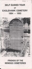
Document - BENDIGO CEMETERIES COLLECTION: SELF GUIDED TOUR EAGLEHAWK CEMETERY DOCUMENT
... Document details significant graves in the old monumental section 1864 - Map of graves and 35 graves described....Document details significant graves in the old monumental section 1864 - Map of graves and 35 graves described. ...BHS CollectionWhite trifold document. Self guided tour of Eaglehawk Cemetery 1864 - 1993 Friends of the Bendigo Cemeteries. Document details significant graves in the old monumental section 1864 - Map of graves and 35 graves described.Annette O'Donohue, Bev Hanson.bendigo, cemetery, eaglehawk cemetery -
 Kiewa Valley Historical Society
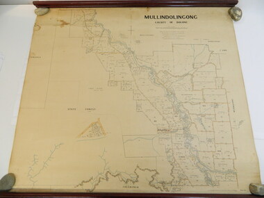
Map - Kiewa Valley, Parish Map of Mullindolingong, 12/10/1906
... This is a very old paper or parchment map with wooden rods top and bottom. ...map; ryder family; early settlers; Mullindolingong County of Bogong. This plan has been prepared by The Most Reliable Data in the Possession of the Department up to the date of its Compilation. Information respecting Leases or Licences which await Final Completion is not recorded. This is a very old ...The map shows the names of people living in the parish of Mullindolingong in 1906. These people had leases or licences giving the reader an insight into the number of people in the area and an understanding of the size of their holdings. Infrastructure is also given including shops, schools, churches etc. Presumably it was used by the Ryder family.This map gives an historical insight into the parish of Mullindolingong as it names people and the infrastructure - roads, buildings etc. as it was in 1906. This enables the reader to compare the area at the time with other times and other places and to have an understanding of the early settlers in the area.This is a very old paper or parchment map with wooden rods top and bottom. The top rod has ribbons attached to enable hanging. The map shows the current leases and licences and when they were held by during this period, circa 1906.Mullindolingong County of Bogong. This plan has been prepared by The Most Reliable Data in the Possession of the Department up to the date of its Compilation. Information respecting Leases or Licences which await Final Completion is not recorded.parish of mullindolingong map; ryder family; early settlers; -
 Bendigo Historical Society Inc.
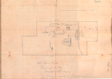
Document - OLD TOM MINE, WHIPSTICK, Possibly 1890's
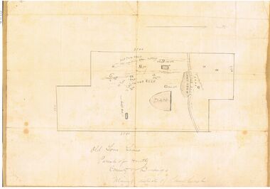
... Handwritten on bottom of map : Old Tom Lease, Parish of Huntly, County of Bendigo, Mining District of Sandhurst. ...Handwritten on bottom of map : Old Tom Lease, Parish of Huntly, County of Bendigo, Mining District of Sandhurst. ...The Old Tom mine site in the Whipstick forest, near Eaglehawk, can still be seen. The shaft has a ringlock fence surrounding it. In 1897, William E. Sheehan, was a mining investor. He applied for a lease "South Loesers Gold Mining Company' in the Whipstick, adjoining the F.G. Loesers lease. His address given as Bath Lane, Bendigo. https://trove.nla.gov.au/newspaper/article/183752133?searchTerm=old%20tom%20wm%20sheehan1. Two page photocopy of handwritten information, signed by Wm. E. Sheehan, on the Old Tom lease in the Whipstick forest. Content describes the condition of the site; the shaft; timbering of shaft; on ground conditions and the extent of the lease. 'In offering the lease I can confidently say that it is without doubt one of the best and safest ventures for small capital that has been placed before the public for many years.' 2. One page sepia photocopy of a 'mud map' of the Old Tom mine site. Map shows water race, dam, reef lines and the boundaries of the lease. Handwritten on bottom of map : Old Tom Lease, Parish of Huntly, County of Bendigo, Mining District of Sandhurst. old tom lease, whipstick forest, eaglehawk, goldmining, william sheehan -
 Robin Boyd Foundation
Document - Script, Robin Boyd, The Flying Dogtor. Episode 38, 1963
... The bush children were following a mysterious map leading to a bushranger's hidden treasure when they were attacked by Crafty Carson Carpetbag and Old Man Redback. ...Robin Boyd Foundation 290 Walsh Street South Yarra melbourne The bush children were following a mysterious map leading to a bushranger's hidden treasure when they were attacked by Crafty Carson Carpetbag and Old Man Redback. ...The bush children were following a mysterious map leading to a bushranger's hidden treasure when they were attacked by Crafty Carson Carpetbag and Old Man Redback. The map fell out of Colin's pocket and was pulled into the bushes. Meanwhile, Granny Goanna worried that the children had not returned home and she radioed The Flying Dogtor.The Flying Dogtor" series was broadcast on Australian Television Network (later becoming the Seven Network) between February and April 1964 (see item D254 for schedule).Typewritten, carbon copy, foolscap, 2 pagesPage 1: top of page, episode number and title cut offthe flying dogtor, robin boyd, crawford productions, manuscript