Showing 75 items matching "operation north west"
-
 National Vietnam Veterans Museum (NVVM)
Photograph, Gibbons, Denis, Medivaced Out
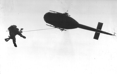
... ...Operation North West...A black and white photograph of a Huey "Slick" aircraft, of the RAAF's No.9 Squadron, winches a wounded Digger from 8 RAR during Operation North West of the Australian Task Force. ...Photograph Huey Helicopter RAAF 9 Squadron Digger 8 RAR Operation North West Australian Task Force Gibbons Collection Catalogue Denis Gibbons A black and white photograph of a Huey "Slick" aircraft, of the RAAF's No.9 Squadron, winches a wounded Digger from 8 RAR during Operation North West of the Australian Task Force. ...Denis Gibbons (1937 – 2011) Trained with the Australian Army, before travelling to Vietnam in January 1966, Denis stayed with the 1st Australian Task Force in Nui Dat working as a photographer. For almost five years Gibbons toured with nine Australian infantry battalions, posting compelling war images from within many combat zones before being flown out in late November 1970 after sustaining injuries. The images held within the National Vietnam Veterans Museum make up the Gibbons Collection. A black and white photograph of a Huey "Slick" aircraft, of the RAAF's No.9 Squadron, winches a wounded Digger from 8 RAR during Operation North West of the Australian Task Force. The Huey helicopter in its many forms was the close support aircraft for the troops on operations in Vietnam.photograph, huey helicopter, raaf, 9 squadron, digger, 8 rar, operation north west, australian task force, gibbons collection catalogue, denis gibbons -
 National Vietnam Veterans Museum (NVVM)
Photograph, Gibbons, Denis, Medivaced Out
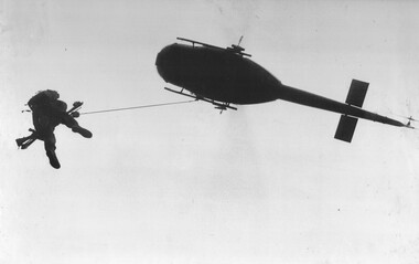
... ...Operation North West...A black and white photograph of a Huey 'slick' aircraft from the RAAF's 9 Squadron, winching a wounded Digger from 8 RAR during 'Operation North West' of the Australian Task Force. ...Photograph 9 Squadron RAAF 1 ATF Nui Dat 8 RAR Digger Operation North West Huey Helicopter Gibbons Collection Catalogue Denis Gibbons Photographer Vietnam War Wounded soldier A black and white photograph of a Huey 'slick' aircraft from the RAAF's 9 Squadron, winching a wounded Digger from 8 RAR during 'Operation North West' of the Australian Task Force. ...Denis Gibbons (1937 – 2011) Trained with the Australian Army, before travelling to Vietnam in January 1966, Denis stayed with the 1st Australian Task Force in Nui Dat working as a photographer. For almost five years Gibbons toured with nine Australian infantry battalions, posting compelling war images from within many combat zones before being flown out in late November 1970 after sustaining injuries. The images held within the National Vietnam Veterans Museum make up the Gibbons Collection.A black and white photograph of a Huey 'slick' aircraft from the RAAF's 9 Squadron, winching a wounded Digger from 8 RAR during 'Operation North West' of the Australian Task Force. The Huey helicopter in its many forms was the close support aircraft for the troops on operations in Vietnam.photograph, 9 squadron, raaf, 1 atf, nui dat, 8 rar, digger, operation north west, huey helicopter, gibbons collection catalogue, denis gibbons, photographer, vietnam war, wounded soldier -
 National Vietnam Veterans Museum (NVVM)
Photograph, Gibbons, Denis, Fire Support Base Peggy
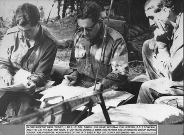
... A black and white photograph of in Fire Support Base 'Peggy', LT Col O'Neill C.O. 8 RAR, with Maj Phil Jeffrey O.C., B Company, and O.C. 161 Battery RNZA study maps during a situation report and an orders group,during Operation Atherton, North West of the 1 ATF Base at Nui Dat (Circa December 1969)...Photograph Support Base Peggy Lt Col O'Neill 8 RAR Maj Phil Jeffrey B Coy 161 Battery 161 battery RNZA Operation Atherton Gibbons Collection Catalogue 1 ATF Base Nui Dat Fire Support Base Peggy Denis Gibbons A black and white photograph of in Fire Support Base 'Peggy', LT Col O'Neill C.O. 8 RAR, with Maj Phil Jeffrey O.C., B Company, and O.C. 161 Battery RNZA study maps during a situation report and an orders group,during Operation Atherton, North West of the 1 ATF Base at Nui Dat (Circa December 1969) Fire Support Base Peggy Photograph Gibbons, Denis ...Denis Gibbons (1937 – 2011) Trained with the Australian Army, before travelling to Vietnam in January 1966, Denis stayed with the 1st Australian Task Force in Nui Dat working as a photographer. For almost five years Gibbons toured with nine Australian infantry battalions, posting compelling war images from within many combat zones before being flown out in late November 1970 after sustaining injuries. The images held within the National Vietnam Veterans Museum make up the Gibbons Collection.Denis Gibbons (1937 – 2011) Trained with the Australian Army, before travelling to Vietnam in January 1966, Denis stayed with the 1st Australian Task Force in Nui Dat working as a photographer. For almost five years Gibbons toured with nine Australian infantry battalions, posting compelling war images from within many combat zones before being flown out in late November 1970 after sustaining injuries. The images held within the National Vietnam Veterans Museum make up the Gibbons Collection. A black and white photograph of in Fire Support Base 'Peggy', LT Col O'Neill C.O. 8 RAR, with Maj Phil Jeffrey O.C., B Company, and O.C. 161 Battery RNZA study maps during a situation report and an orders group,during Operation Atherton, North West of the 1 ATF Base at Nui Dat (Circa December 1969)photograph, support base peggy, lt col o'neill, 8 rar, maj phil jeffrey, b coy, 161 battery, 161 battery rnza, operation atherton, gibbons collection catalogue, 1 atf base, nui dat, fire support base peggy, denis gibbons -
 National Vietnam Veterans Museum (NVVM)
Photograph, Gibbons, Denis, Waiting For The Winch
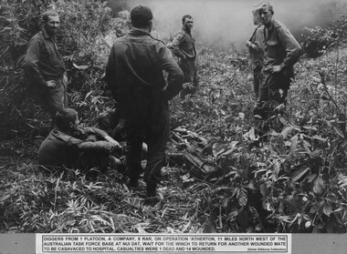
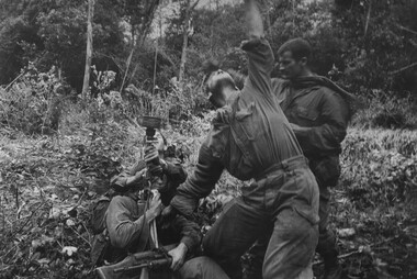
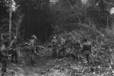
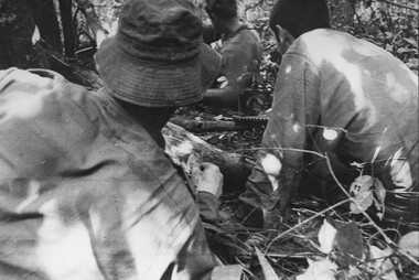
... A black and white photograph of diggers from 1 Platoon, A Company, 8 RAR on Operation Atherton, 11 miles North West of the Australian Task Force Base at Nui Dat, wait for the winch to return for another wounded mate to be casavaced to hospital. ...National Vietnam Veterans Museum (NVVM) 25 Veterans Drive Newhaven phillip-island-and-the-bass-coast Photograph 1 Platoon A Coy 8 RAR Operation Atherton Gibbons Collection Catalogue Australian Task Force Nui Dat Wounded Serviceman Diggers A black and white photograph of diggers from 1 Platoon, A Company, 8 RAR on Operation Atherton, 11 miles North West of the Australian Task Force Base at Nui Dat, wait for the winch to return for another wounded mate to be casavaced to hospital. ...A black and white photograph of diggers from 1 Platoon, A Company, 8 RAR on Operation Atherton, 11 miles North West of the Australian Task Force Base at Nui Dat, wait for the winch to return for another wounded mate to be casavaced to hospital. Casualties were 1 dead and 14 wounded.photograph, 1 platoon, a coy, 8 rar, operation atherton, gibbons collection catalogue, australian task force, nui dat, wounded serviceman, diggers -
 National Vietnam Veterans Museum (NVVM)
Photograph, Gibbons, Denis, Winch Extraction
... A black and white photograph of Diggers from 1 Platoon, A Company, 8 RAR on Operation Atherton, 11 miles North West of the Australian Task Force Base, Nui Dat, signal the Dustoff crew to operate the winch for a wounded mate casevaced to hospital. ...Photograph 1 ATF Operation Atherton A Coy 8 RAR Dustoff Gibbons Collection Catalogue Digger Australian Task Force Nui Dat Wounded Serviceman Killed in Action Denis Gibbons A black and white photograph of Diggers from 1 Platoon, A Company, 8 RAR on Operation Atherton, 11 miles North West of the Australian Task Force Base, Nui Dat, signal the Dustoff crew to operate the winch for a wounded mate casevaced to hospital. ...Denis Gibbons (1937 – 2011) Trained with the Australian Army, before travelling to Vietnam in January 1966, Denis stayed with the 1st Australian Task Force in Nui Dat working as a photographer. For almost five years Gibbons toured with nine Australian infantry battalions, posting compelling war images from within many combat zones before being flown out in late November 1970 after sustaining injuries. The images held within the National Vietnam Veterans Museum make up the Gibbons Collection. A black and white photograph of Diggers from 1 Platoon, A Company, 8 RAR on Operation Atherton, 11 miles North West of the Australian Task Force Base, Nui Dat, signal the Dustoff crew to operate the winch for a wounded mate casevaced to hospital. Casualities were 1 dead and 14 wounded.photograph, 1 atf, operation atherton, a coy, 8 rar, dustoff, gibbons collection catalogue, digger, australian task force, nui dat, wounded serviceman, killed in action, denis gibbons -
 National Vietnam Veterans Museum (NVVM)
Photograph, Gibbons, Denis, Winch Extraction Preparation
... A black and white photograph of Diggers from 1 Platoon, A Company, 8 RAR on Operation Atherton, 11 miles North West of the Australain Task Force Base, Nui Dat, prepare a wounded mate for winching out of thick jungle to be casevaced to hospital, casualities were 1 dead and 14 wounded....Photograph 1 ATF Operation Atherton 1 Platoon A Coy 8 RAR Dustoff Gibbons Collection Catalogue Australian Task Force Nui Dat Diggers Wounded Serviceman Killed in Action Denis Gibbons A black and white photograph of Diggers from 1 Platoon, A Company, 8 RAR on Operation Atherton, 11 miles North West of the Australain Task Force Base, Nui Dat, prepare a wounded mate for winching out of thick jungle to be casevaced to hospital, casualities were 1 dead and 14 wounded. ...Denis Gibbons (1937 – 2011) Trained with the Australian Army, before travelling to Vietnam in January 1966, Denis stayed with the 1st Australian Task Force in Nui Dat working as a photographer. For almost five years Gibbons toured with nine Australian infantry battalions, posting compelling war images from within many combat zones before being flown out in late November 1970 after sustaining injuries. The images held within the National Vietnam Veterans Museum make up the Gibbons Collection. A black and white photograph of Diggers from 1 Platoon, A Company, 8 RAR on Operation Atherton, 11 miles North West of the Australain Task Force Base, Nui Dat, prepare a wounded mate for winching out of thick jungle to be casevaced to hospital, casualities were 1 dead and 14 wounded.photograph, 1 atf, operation atherton, 1 platoon, a coy, 8 rar, dustoff, gibbons collection catalogue, australian task force, nui dat, diggers, wounded serviceman, killed in action, denis gibbons -
 National Vietnam Veterans Museum (NVVM)
Photograph, Gibbons, Denis, Winched Out
... A black and white photograph of diggers from 1 Platoon, A Company, 8 RAR on Operation Atherton 11 miles North West of the Australian Task Force Base at Nui Dat, watch one of their wounded mates winched out of the thick jungle to be casavaced to hospital. ...Photograph 1 Platoon A Coy 8 RAR Operation Atherton Gibbons Collection Catalogue Wounded Serviceman Australian Task Force Nui Dat Diggers Killed in Action Denis Gibbons A black and white photograph of diggers from 1 Platoon, A Company, 8 RAR on Operation Atherton 11 miles North West of the Australian Task Force Base at Nui Dat, watch one of their wounded mates winched out of the thick jungle to be casavaced to hospital. ...Denis Gibbons (1937 – 2011) Trained with the Australian Army, before travelling to Vietnam in January 1966, Denis stayed with the 1st Australian Task Force in Nui Dat working as a photographer. For almost five years Gibbons toured with nine Australian infantry battalions, posting compelling war images from within many combat zones before being flown out in late November 1970 after sustaining injuries. The images held within the National Vietnam Veterans Museum make up the Gibbons Collection. A black and white photograph of diggers from 1 Platoon, A Company, 8 RAR on Operation Atherton 11 miles North West of the Australian Task Force Base at Nui Dat, watch one of their wounded mates winched out of the thick jungle to be casavaced to hospital. Casualities were 1 dead and 14 wounded.photograph, 1 platoon, a coy, 8 rar, operation atherton, gibbons collection catalogue, wounded serviceman, australian task force, nui dat, diggers, killed in action, denis gibbons -
 National Vietnam Veterans Museum (NVVM)
Photograph, Gibbons, Denis, Extracting A Wounded Digger
... A black and white photograph of diggers from 1 Platoon, A Company, 8 RAR, on Operation Atherton, 11 miles North West of the Australian Task Force Base at Nui Dat, led by Cpl Ian Torrens, extract a wounded digger by dragging him by the scruff of the neck. ...Photograph 1 Platoon A Coy 8 RAR Gibbons Collection Catalogue Operation Atherton Cpl Ian Torrens Wounded Serviceman KIA Australian Task Force Diggers Killed in Action Denis Gibbons A black and white photograph of diggers from 1 Platoon, A Company, 8 RAR, on Operation Atherton, 11 miles North West of the Australian Task Force Base at Nui Dat, led by Cpl Ian Torrens, extract a wounded digger by dragging him by the scruff of the neck. ...Denis Gibbons (1937 – 2011) Trained with the Australian Army, before travelling to Vietnam in January 1966, Denis stayed with the 1st Australian Task Force in Nui Dat working as a photographer. For almost five years Gibbons toured with nine Australian infantry battalions, posting compelling war images from within many combat zones before being flown out in late November 1970 after sustaining injuries. The images held within the National Vietnam Veterans Museum make up the Gibbons Collection. A black and white photograph of diggers from 1 Platoon, A Company, 8 RAR, on Operation Atherton, 11 miles North West of the Australian Task Force Base at Nui Dat, led by Cpl Ian Torrens, extract a wounded digger by dragging him by the scruff of the neck. Casualities were 1 dead and 14 wounded.photograph, 1 platoon, a coy, 8 rar, gibbons collection catalogue, operation atherton, cpl ian torrens, wounded serviceman, kia, australian task force, diggers, killed in action, denis gibbons -
 Warrnambool and District Historical Society Inc.
Document, Share Certificate
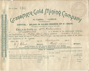
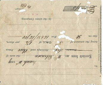
... north west of Swifts Creek. The gold-bearing quartz reefs were discovered in 1885 and worked to 1914. It is not known whether the Grassmere Cassilis mine was a financial success but the mining operations were impeded by the hardness of the stone in the area. ...north west of Swifts Creek. The gold-bearing quartz reefs were discovered in 1885 and worked to 1914. It is not known whether the Grassmere Cassilis mine was a financial success but the mining operations were impeded by the hardness of the stone in the area. ...Grassmere is a small hamlet about 12 kilometres from Warrnambool. It is a farming area. The Grassmere Gold Mining Company, presumably established by local people in Grassmere, was created in 1898 for the purpose of acquiring from Messrs James and Mewha a lease of a Cassilis gold mine (23 acres). £5000 was to be raised in shares of five shillings and one shilling each. The Manager of the Company was Horatio Dickson of Melbourne and the brokers were McMeekin and Co. of Melbourne and Warrnambool and Dickson and Osborne of Melbourne. This reef mine was one of several in Cassilis, Gippsland, 12 kilometres north west of Swifts Creek. The gold-bearing quartz reefs were discovered in 1885 and worked to 1914. It is not known whether the Grassmere Cassilis mine was a financial success but the mining operations were impeded by the hardness of the stone in the area. William Robinson was a farmer in the Grassmere district. This certificate is of considerable interest as one of only three items the Warrnambool and District Historical Society has that is connected with the establishment of the Grassmere Gold Mining Company. The gold mine establishment was one of the many minor events in the district in the 1890s. This is a small buff-coloured certificate detailing the shares of William Robinson in the Grassmere Gold Mining Company (1898). The certificate has green printing and black-ink handwriting. The bottom section (Form of Transfer) is not filled in. There is a stamp of the Grassmere Gold Mining Company with the words ‘No Liability’. There is a decorative pattern in green on the left margin with the address of the company and the name of the printer. ‘This is to certify that Wm. Robinson of Grassmere is a member of the above-named company and the proprietor of fifty (50) shares, numbering 12651/12700 therein, upon which the sum of one shilling has been paid up, subject to the Rules and Regulations of the Company. Dated this 15th day of September, 1898. W.J. Roland, Director, .H. (es) Dickson, Manager.’grassmere, grassmere gold mining company, william robinson, warrnambool -
 Warrnambool and District Historical Society Inc.
Document, Receipt March 11 1899, 1898
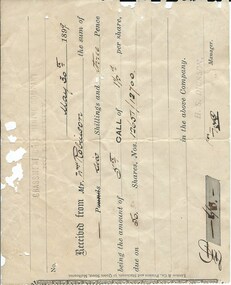
... north west of Swifts Creek. The gold-bearing quartz reefs were discovered in 1885 and worked to 1914. It is not known whether the Grassmere Cassilis mine was a financial success but the mining operations were impeded by the hardness of the stone in the area. ...north west of Swifts Creek. The gold-bearing quartz reefs were discovered in 1885 and worked to 1914. It is not known whether the Grassmere Cassilis mine was a financial success but the mining operations were impeded by the hardness of the stone in the area. ...Grassmere is a small hamlet about 12 kilometres from Warrnambool. It is a farming area. The Grassmere Gold Mining Company, presumably established by local people in Grassmere, was created in 1898 for the purpose of acquiring from Messrs James and Mewha a lease of a Cassilis gold mine (23 acres). £5000 was to be raised in shares of five shillings and one shilling each. The Manager of the Company was Horatio Dickson of Melbourne and the brokers were McMeekin and Co. of Melbourne and Warrnambool and Dickson and Osborne of Melbourne. This reef mine was one of several in Cassilis, Gippsland, 12 kilometres north west of Swifts Creek. The gold-bearing quartz reefs were discovered in 1885 and worked to 1914. It is not known whether the Grassmere Cassilis mine was a financial success but the mining operations were impeded by the hardness of the stone in the area. William Robinson was a farmer in the Grasmere district. This receipt is of considerable interest as one of only three items the Warrnambool and District Historical Society has that is connected to the Grassmere Gold Mining Company. The gold mine establishment was one of the minor events in the district in the 1890s. This is a buff-coloured 1899 receipt for William Robinson who has paid six shillings and threepence for part payment of his shares in the Grassmere Gold Mining Company. The receipt has black printing and black-ink handwriting. There is one stamp of the Manager ‘H.S. Dickson’ and another of ‘Grassmere Gold Mining Company No Liability’. The receipt has several holes caused by silver fish damage. ‘March 11th 1899, Received from Mr Wm. Robinson the sum of six shillings and threepence being the amount of 3rd call of 1½ per share due on 50 shares nos. 12651/12700 in the above Company, H.S.Dickson, Manager’ grassmere, grassmere gold mining company, william robinson -
 Warrnambool and District Historical Society Inc.
Financial record - Receipt: Grassmere Gold Mining Company, 1898
... north west of Swifts Creek. The gold-bearing quartz reefs were discovered in 1885 and worked to 1914. It is not known whether the Grassmere Cassilis mine was a financial success but the mining operations were impeded by the hardness of the stone in the area. ...north west of Swifts Creek. The gold-bearing quartz reefs were discovered in 1885 and worked to 1914. It is not known whether the Grassmere Cassilis mine was a financial success but the mining operations were impeded by the hardness of the stone in the area. ...Grassmere is a small hamlet about 12 kilometres from Warrnambool. It is a farming area. The Grassmere Gold Mining Company, presumably established by local people in Grassmere, was created in 1898 for the purpose of acquiring from Messrs James and Mewha a lease of a Cassilis gold mine (23 acres). The Manager of the Company was Horatio Dickson of Melbourne and the brokers were McMeekin and Co. of Melbourne and Warrnambool and Dickson and Osborne of Melbourne. This reef mine was one of several in Cassilis, Gippsland, 12 kilometres north west of Swifts Creek. The gold-bearing quartz reefs were discovered in 1885 and worked to 1914. It is not known whether the Grassmere Cassilis mine was a financial success but the mining operations were impeded by the hardness of the stone in the area. William Robinson was a farmer in the Grasmere area. This receipt is of considerable interest as one of only three items the Warrnambool and District Historical Society that is connected to the establishment of the Grassmere Gold Mining Company. The gold mine establishment was one of the many minor events in the district in the 1890s. This is an 1899 receipt for William Robinson upon payment of six shillings and three pence, being part payment for shares in the Grassmere Gold Mining Company. The buff-coloured paper has black printing and black-ink handwriting. There are two stamps – one is the stamp of ‘H.S.Dickson’ and the other is the stamp of the ‘Grassmere Gold Mining Company, No Liability’. The certificate has silver fish damage at the top and the right-hand side‘May 30th 1899, Received from Mr Wm. Robinson the sum of six shillings and three pence, being the amount of 5th call of 1½ per share, due on 50 shares, nos. 12651/12700 in the above company, H.S. Dickson, Manager’grassmere, grassmere gold mining company, william robinson, warrnambool -
 Bendigo Military Museum
Photograph - RA Svy Project C4 Aerodist Operation, Eastern Arnhem Land, NT, 1967
... operations for 12 years from 1964 to 1975. Aerodist MRC2 was a tellurometer-based system adapted for aircraft to accurately measure distances between non-intervisible ground survey stations, using the aircraft as an intermediate station. Lower order geodetic results could be achieved by survey network trilateration. The measured distances between stations formed survey networks from which each station’s latitude and longitude was computed. Aerodist MRC2 was RA Svy’s major horizontal control survey tool for mainly medium scale topographic mapping (scale 1:100,000 Class A being spatially accurate to within 50 metres) in PNG, northern NT, north-west...operations for 12 years from 1964 to 1975. Aerodist MRC2 was a tellurometer-based system adapted for aircraft to accurately measure distances between non-intervisible ground survey stations, using the aircraft as an intermediate station. Lower order geodetic results could be achieved by survey network trilateration. The measured distances between stations formed survey networks from which each station’s latitude and longitude was computed. Aerodist MRC2 was RA Svy’s major horizontal control survey tool for mainly medium scale topographic mapping (scale 1:100,000 Class A being spatially accurate to within 50 metres) in PNG, northern NT, north-west ...This is a set of 30 photographs of Royal Australian Survey Corps (RA Svy) personnel from Central Comd Fd Svy Unit (Adelaide) on Aerodist survey operation - Project C4 in Eastern Arnhem Land, Northern Territory in 1967. Photos of personnel were taken either at the operations base at Numbulwar or the main base at Gove (Nhulunbuy). RA Svy conducted nineteen Aerodist operations for 12 years from 1964 to 1975. Aerodist MRC2 was a tellurometer-based system adapted for aircraft to accurately measure distances between non-intervisible ground survey stations, using the aircraft as an intermediate station. Lower order geodetic results could be achieved by survey network trilateration. The measured distances between stations formed survey networks from which each station’s latitude and longitude was computed. Aerodist MRC2 was RA Svy’s major horizontal control survey tool for mainly medium scale topographic mapping (scale 1:100,000 Class A being spatially accurate to within 50 metres) in PNG, northern NT, north-west WA, Kalimantan Barat (West) Indonesia, Sumatra Indonesia, Gulf of Carpentaria and Cape York, QLD. In 1967, the Aerodist MRC2 Master equipment was installed in the aircraft featured in this set of photos, Executive Air Services’ (Essendon VIC) Grand Aero Commander VH-EXX. It was the same aircraft type and company contracted to Division of National Mapping for Aerodist MRC2 surveys. From July to October 1967 the aircraft was attached to Central Comd Fd Svy Unit (Adelaide - Major Don Ridge) on Project C4 eastern-Arnhem Land NT, where 317 Aerodist lines measuring 17,300 line miles were successfully completed. This was the most productive Aerodist project thus far. The most common helicopter used by RA Svy up to 1972 was the civilian Bell 47G-2 and the Sioux Light Observation Helicopters (LOH), the Australian Army’s equivalent featured in this photo set. These light observation helicopters had a limiting load carrying capacity of up to about 500 pounds. By comparison, one Aerodist team including two people weighed up to 1,500 pounds. Source: Royal Australian Survey Corps – Aerodist Years 1964-1975 by Peter Jensen. Refer to Item 9061.26P for more photos taken during this Aerodist survey operation.This is a set of 30 photographs of Royal Australian Survey Corps (RA Svy) personnel on Aerodist survey operations in Eastern Arnhem Land, Northern Territory in 1967. The photographs are on 35mm negative film and scanned at 96 dpi. They are part of the Army Survey Regiment’s Collection. .1) to .4) - black & white, 20th August 1967, Project C4 Aerodist Operations Base - Numbulwar, NT. .5) - Photo, black & white, 1967. Probable wrecked Indonesian fishing vessel. .6) to .8) - Photo, black & white, 1967. Unidentified survey operations base, L to R: unidentified personnel. .9) - Photo, black & white, 1967. Unidentified survey operations base, unidentified soldier driving a Haflinger 4x4 Light utility vehicle. .10) - Photo, black & white, 1967. Unidentified survey operations base, L to R: unidentified technician. .11) - Unidentified technician reading two survey altimeters to compute corrections to the measured distances for atmospheric refraction and to compute the sea level distances from the slope distances aircraft to the ground stations. .12) - Photo, black & white, 1967. Survey operations base, L to R: unidentified (x3), W01 Pat Wood BEM, unidentified. .13) to .16) - Photo, black & white, 1967. Unidentified personnel operating remote Aerodist MRC2 ground instruments. .17) to .18) - Photo, black & white, 1967. Unknown RA Svy office location. .19) to .20) - Photo, black & white, 1967. Aerodist MRC2 Master equipment. .21) to .22) - Photo, black & white, 1967. Aero Commander VH-EXX probably at Gove, NT, Central Comd Fd Svy Unit (Adelaide) – OC Major Don Ridge. .23) to .25) - Photo, black & white, 1967. Aero Commander VH-EXX probably at Gove, NT. Unidentified personnel. .26) - Photo, black & white, 1967. Aero Commander VH-EXX probably at Gove, NT. Aerodist antenna pods are visible on the aircraft. .27) to .29) - Photo, black & white, 1967. Australian Army Sioux Light Observation Helicopter (LOH) probably at Gove, NT. .30) - Photo, black & white, 1967. Panelled U337 survey station, visible as a white cross on aerial identification photo..1P to .2P – date and location on edge of film negative. .5P to .28P – no annotations .29P - annotated in white ‘RW-JEP Gove NT’ .30P - annotated in white ‘U337 Spool No1 Jun67’royal australian survey corps, rasvy, army survey regiment, army svy regt, fortuna, asr, aerodist, surveying, central comd fd svy unit -
 Bendigo Military Museum
Map - MAPS, EAST TIMOR, US Govt et al, 1975 - 1976
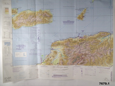
... operations graphic. It covers the North side of East Timor. Dili is in the centre. Its shows 4 Islands to the north of Timor. It shows Savu Fea, Ombai Strait, Wetar Strait. On bottom left of map it shows Batheade and the start of the New Border. Map - Series 159. Sheet 5C- 51-4. Edition 3-GSGS. 2. This is a coloured map. Its scale is 1.250,000 called a joint Operations Graphic. It manly covers West...operations graphic. It covers the North side of East Timor. Dili is in the centre. Its shows 4 Islands to the north of Timor. It shows Savu Fea, Ombai Strait, Wetar Strait. On bottom left of map it shows Batheade and the start of the New Border. Map - Series 159. Sheet 5C- 51-4. Edition 3-GSGS. 2. This is a coloured map. Its scale is 1.250,000 called a joint Operations Graphic. It manly covers West ...1. This is a coloured map. It's scale is 1.250,000 - called a jpoint operations graphic. It covers the North side of East Timor. Dili is in the centre. Its shows 4 Islands to the north of Timor. It shows Savu Fea, Ombai Strait, Wetar Strait. On bottom left of map it shows Batheade and the start of the New Border. Map - Series 159. Sheet 5C- 51-4. Edition 3-GSGS. 2. This is a coloured map. Its scale is 1.250,000 called a joint Operations Graphic. It manly covers West Timor. It shows Savu Sea in North and Timor Sea on south side. Series 1501. Sheet SC 51.7. Edition 3-GSGS. 3. This a coloured map. It's scale is 1.250,000. Joint operations graphic. This map shows the south side of East Timor and the Timor Sea. This map shows a highlighted New border. The major towns on South coast are KAMFNASA, BETANO. Map series 1501. Sheet SC 51-8. Edition 3 GSGS.1. Has highlighted "7 BSG" on coast. All maps show East Timor border highlighted in pink.east timor, maps, interfet -
 Bendigo Military Museum
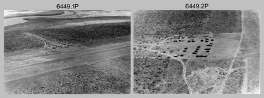
Photograph - RA Svy Project C4 Aerodist Operation, Eastern & Western Arnhem Land, NT, 1967, 1968
... operations for 12 years from 1964 to 1975. Aerodist MRC2 was a tellurometer-based system adapted for aircraft to accurately measure distances between non-intervisible ground survey stations, using the aircraft as an intermediate station. Lower order geodetic results could be achieved by survey network trilateration. The measured distances between stations formed survey networks from which each station’s latitude and longitude was computed. Aerodist MRC2 was RA Svy’s major horizontal control survey tool for mainly medium scale topographic mapping (scale 1:100,000 Class A being spatially accurate to within 50 metres) in PNG, northern NT, north-west...operations for 12 years from 1964 to 1975. Aerodist MRC2 was a tellurometer-based system adapted for aircraft to accurately measure distances between non-intervisible ground survey stations, using the aircraft as an intermediate station. Lower order geodetic results could be achieved by survey network trilateration. The measured distances between stations formed survey networks from which each station’s latitude and longitude was computed. Aerodist MRC2 was RA Svy’s major horizontal control survey tool for mainly medium scale topographic mapping (scale 1:100,000 Class A being spatially accurate to within 50 metres) in PNG, northern NT, north-west ...This is a set of 26 photographs of Royal Australian Survey Corps (RA Svy) personnel from Central Comd Fd Svy Unit (Adelaide) on Aerodist survey operation - Project C4 in Eastern Arnhem Land, Northern Territory in 1967 (photos .4P to .26P) and in Western Arnhem Land, Northern Territory in 1968 (photos .1P to .3P). Photos of personnel were taken either at the operations base at Numbulwar or the main base at Gove (Nhulunbuy). RA Svy conducted nineteen Aerodist operations for 12 years from 1964 to 1975. Aerodist MRC2 was a tellurometer-based system adapted for aircraft to accurately measure distances between non-intervisible ground survey stations, using the aircraft as an intermediate station. Lower order geodetic results could be achieved by survey network trilateration. The measured distances between stations formed survey networks from which each station’s latitude and longitude was computed. Aerodist MRC2 was RA Svy’s major horizontal control survey tool for mainly medium scale topographic mapping (scale 1:100,000 Class A being spatially accurate to within 50 metres) in PNG, northern NT, north-west WA, Kalimantan Barat (West) Indonesia, Sumatra Indonesia, Gulf of Carpentaria and Cape York, QLD. In 1967, the Aerodist MRC2 Master equipment was installed in the aircraft featured in this set of photos, Executive Air Services’ (Essendon VIC) Grand Aero Commander VH-EXX. It was the same aircraft type and company contracted to Division of National Mapping for Aerodist MRC2 surveys. From July to October 1967 the aircraft was attached to Central Comd Fd Svy Unit (Adelaide - Major Don Ridge) on Project C4 eastern-Arnhem Land NT, where 317 Aerodist lines measuring 17,300 line miles were successfully completed. This was the most productive Aerodist project thus far. The most common helicopter used by RA Svy up to 1972 was the civilian Bell 47G-2 and the Sioux Light Observation Helicopters (LOH), the Australian Army’s equivalent featured in this photo set. These light observation helicopters had a limiting load carrying capacity of up to about 500 pounds. By comparison, one Aerodist team including two people weighed up to 1,500 pounds. In 1968, after completion of the Kimberley Aerodist Operation project, the Aerodist system in VH-EXX was immediately deployed to western-Arnhem Land NT for Central Comd Fd Svy Unit (Adelaide - Major Don Ridge) to complete the mapping control across northern NT from mid-July to October. The Aerodist MRC2 Remote antenna seen in Photos .24P to .26P is mounted on a 20 foot pole tower. The antenna direction was controlled by wires/ropes to the two arms under the dish at right angles. The antenna elevation could be changed to the vertical for aircraft height checks as seen in photo .25P. Source: Royal Australian Survey Corps – Aerodist Years 1964-1975 by Peter Jensen. Refer to Item 6449.30P for more photos taken during these Aerodist survey operations.This is a set of 26 photographs of Royal Australian Survey Corps (RA Svy) personnel on Aerodist survey operations in Eastern Arnhem Land, Northern Territory in 1967 and Western Arnhem Land, Northern Territory in 1968. The photographs are on 35mm negative film and scanned at 96 dpi. They are part of the Army Survey Regiment’s Collection. .1) to .2) – Photo, black & white, 1968, unidentified soldier with an opened can of food, possibly bully beef. .3) – Photo, black & white, 15 Aug 1968, aerial view of terrain taken from a helicopter in vicinity of MILINGIMBI SIERRA. .4) – Photo, black & white, 1967, aerial view of an island taken from a helicopter. .5) & .6) – Photo, black & white, 1967, unidentified soldier driving a Haflinger 4x4 Light utility vehicle with trailer. .7) – Photo, black & white, 1967, unidentified surveyors taking vertical measurements with a leveling instrument and staff. .8) – Photo, black & white, 1967, Australian Army Sioux Light Observation Helicopter (LOH) with float removed. .9) to .11) – Photo, black & white, 1967, Australian Army Sioux Light Observation Helicopter (LOH) with floats. .12) – Photo, black & white, 1967, civilian Bell 47G-2 helicopter (Australian Army Sioux LOH equivalent) refuelled. .13) – Photo, black & white, 1967, survey station on coastline surrounded by white plastic aerial photographic identification panels lined with rocks. .14) & .15) – Photo, black & white, 1967, soldier (possibly a signaller from RA Sigs) operating a radio. .16) – Photo, black & white, 1967, Central Comd Fd Svy Unit Operations Section tent, Main Base Gove (Nhulunbuy) L to R: SPR Harry Dunn, WO1 Pat Wood BEM. .17) – Photo, black & white, 1967, Central Comd Fd Svy Unit Operations Section tent, Main Base Gove (Nhulunbuy) L to R: unidentified, WO1 Pat Wood BEM. .18) – Photo, black & white, 1967, Central Comd Fd Svy Unit Operations Section, Main Base Gove (Nhulunbuy), unidentified Australian Army Catering Corps cook preparing meals. .19) – Photo, black & white, 1967, Central Comd Fd Svy Unit Operations Section, Main Base Gove (Nhulunbuy) mess tent in readiness for meals. .20) – Photo, black & white, 1967, Bank of batteries in transit boxes undergoing recharging using generators. .21) – Photo, black & white, 1967, A topographic survey identification plaque set in a concrete block being weighed using a set of scales hanging from slaughtering gallows. .22) – Photo, black & white, 1967, CPL (Geoff or Gary) Larkin operating the remote Aerodist MRC2 ground instrument at Veronica Island, located north of Nhulunbuy. .23) – Photo, black & white, 1967, L to R: CPL (Geoff or Gary) Larkin with unidentified surveyor operate the remote Aerodist MRC2 ground instrument at Venica Island, located north of Nhulunbuy. .24) & .25 – Photo, black & white, 1967, The Aerodist MRC2 Remote antenna. .26) – Photo, black & white, 1967, The Aerodist MRC2 Remote antenna.The following photos are annotated in black ink on edge of film negative: .3P – ’15 Aug ’68, 2000’, 1-C18 ’68 MILINGIMBI SIERRA’ .4P – ’U462’ .8P – ‘1-C3/67 Float Removed’ .13P – ‘U477 10-C3/67 .20P - ‘2-C3/67 Bank of Chargers’ .21P - ‘3-C3/67 Gallows & Scales’ .22P - ‘0462 VERONICA ISLAND NT, CPL Larkin’ .23P - ‘0462 VERONICA ISLAND NT’ .24P - ‘4-C3/67 20’ Aerodist Tower’ .25P - ‘5-C3/67 20’ Aerodist Tower’ .26P - ‘6-C3/67 20’ Aerodist Tower’royal australian survey corps, rasvy, army survey regiment, army svy regt, fortuna, asr, aerodist, surveying, central comd fd svy unit -
 4th/19th Prince of Wales's Light Horse Regiment Unit History Room
Medals, Africa Star, abt 1945
... North Africa from the date of the entry of Italy into the war on 10 June 1940, up to the date of the cessation of operations against the enemy in North Africa on 12 May 1943. The Africa Star may also be awarded for operational service as a member of the Australian Defence Force during the Syrian Campaign in the period from 8 June 1941 to 11 July 1941. Eligibility This medal is awarded for a minimum of one days operational service in North Africa, west...North Africa from the date of the entry of Italy into the war on 10 June 1940, up to the date of the cessation of operations against the enemy in North Africa on 12 May 1943. The Africa Star may also be awarded for operational service as a member of the Australian Defence Force during the Syrian Campaign in the period from 8 June 1941 to 11 July 1941. Eligibility This medal is awarded for a minimum of one days operational service in North Africa, west ...The Africa Star was granted for operational service in North Africa from the date of the entry of Italy into the war on 10 June 1940, up to the date of the cessation of operations against the enemy in North Africa on 12 May 1943. The Africa Star may also be awarded for operational service as a member of the Australian Defence Force during the Syrian Campaign in the period from 8 June 1941 to 11 July 1941. Eligibility This medal is awarded for a minimum of one days operational service in North Africa, west of the Suez Canal between 10 June 1940 and 12 May 1943 and in Syria between 8 June 1941 and 11 July 1941. The Medal The Africa Star is a six–pointed star of yellow copper zinc alloy. The obverse has a central design of the Royal and Imperial cypher, surmounted by a crown. The cypher is surrounded by a circlet containing the words ‘The Africa Star'. Stars issued to Australian personnel have recipient names engraved on the plain reverse. The Ribbon The Africa Star ribbon colours represent the desert and the service of the Armies, Naval Forces, Merchant Navy and the Air Forces. Clasps Three clasps were issued for the Africa Star: 8 th Army 1 st Army North Africa 1942-43 Only one clasp is worn and when the ribbon is worn alone a ribbon emblem, ‘8', ‘1' or silver rosette as appropriate is worn to denote the award of a clasp.Full size and miniature Africa Star medals. Miniature has clasps: North Africa 1942-43 8th Army 1st ArmyNo recipient engraved -
4th/19th Prince of Wales's Light Horse Regiment Unit History Room
Medal, Africa Star, abt 1945
... North Africa from the date of the entry of Italy into the war on 10 June 1940, up to the date of the cessation of operations against the enemy in North Africa on 12 May 1943. The Africa Star may also be awarded for operational service as a member of the Australian Defence Force during the Syrian Campaign in the period from 8 June 1941 to 11 July 1941. This medal is awarded for a minimum of one days operational service in North Africa, west...North Africa from the date of the entry of Italy into the war on 10 June 1940, up to the date of the cessation of operations against the enemy in North Africa on 12 May 1943. The Africa Star may also be awarded for operational service as a member of the Australian Defence Force during the Syrian Campaign in the period from 8 June 1941 to 11 July 1941. This medal is awarded for a minimum of one days operational service in North Africa, west ...The Africa Star was granted for operational service in North Africa from the date of the entry of Italy into the war on 10 June 1940, up to the date of the cessation of operations against the enemy in North Africa on 12 May 1943. The Africa Star may also be awarded for operational service as a member of the Australian Defence Force during the Syrian Campaign in the period from 8 June 1941 to 11 July 1941. This medal is awarded for a minimum of one days operational service in North Africa, west of the Suez Canal between 10 June 1940 and 12 May 1943 and in Syria between 8 June 1941 and 11 July 1941. Clasps Three clasps were issued for the Africa Star: 8 th Army 1 st Army North Africa 1942-43 Only one clasp is worn and when the ribbon is worn alone a ribbon emblem, ‘8', ‘1' or silver rosette as appropriate is worn to denote the award of a clasp. The Medal The Africa Star is a six–pointed star of yellow copper zinc alloy. The obverse has a central design of the Royal and Imperial cypher, surmounted by a crown. The cypher is surrounded by a circlet containing the words ‘The Africa Star'. Stars issued to Australian personnel have recipient names engraved on the plain reverse. The Ribbon The Africa Star ribbon colours represent the desert and the service of the Armies, Naval Forces, Merchant Navy and the Air Forces. Recipient is not engraved on reverse, so, either a replica or not issued to Australianmedal africa star -
 Bendigo Historical Society Inc.
Document - MCCOLL, RANKIN AND STANISTREET COLLECTION: INDENTURE GOLD MINING LEASE 9201 BALLAARAT
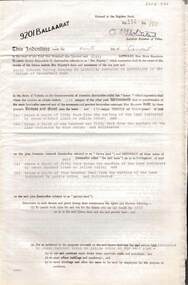
... 6 page document plus map: indenture, gold mining lease dated 9th August 1960, between the Crown and North Deborah Mining Company, carrying on operations in the Parish of Moorarbool West . ...History House 11 Mackenzie Street Bendigo goldfields BENDIGO Mining Deborah Gold Mines 6 page document plus map: indenture, gold mining lease dated 9th August 1960, between the Crown and North Deborah Mining Company, carrying on operations in the Parish of Moorarbool West . ...6 page document plus map: indenture, gold mining lease dated 9th August 1960, between the Crown and North Deborah Mining Company, carrying on operations in the Parish of Moorarbool West . Key on map indicates depth to which land may be excised. On map: Mining District of Ballarat, County of Grant, Parish of Moorarbool West. Total area: 285 acres 1 rood, 20 perches. Vol 334, Fol 202.bendigo, mining, deborah gold mines -
 The Beechworth Burke Museum
Geological specimen - Chalcopyrite
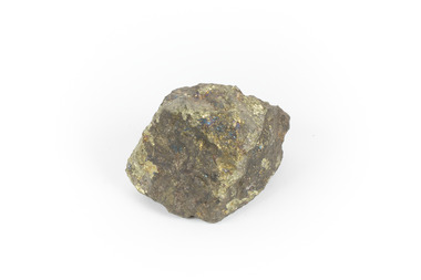
... west coast of Tasmania, where a large group of open cut and underground copper-silver-gold mines began operating in 1883. Between 1893-1994, the Mt Lyell Mining and Railway Company were responsible for operations. The Mt Lyell copper-gold mines produce some excellent crystallised specimens of chalcopyrite and other minerals. The deposits are generally considered to be of Cambrian volcanic origin, but there are indications of Devonian granitic influence on the ores, plus local remobilisation during Devonian deformation. Over 120 million tonnes of ore was produced from several workings, including the main Prince Lyell mine and the North...west coast of Tasmania, where a large group of open cut and underground copper-silver-gold mines began operating in 1883. Between 1893-1994, the Mt Lyell Mining and Railway Company were responsible for operations. The Mt Lyell copper-gold mines produce some excellent crystallised specimens of chalcopyrite and other minerals. The deposits are generally considered to be of Cambrian volcanic origin, but there are indications of Devonian granitic influence on the ores, plus local remobilisation during Devonian deformation. Over 120 million tonnes of ore was produced from several workings, including the main Prince Lyell mine and the North ...This specimen originated from Mount Lyell on the west coast of Tasmania, where a large group of open cut and underground copper-silver-gold mines began operating in 1883. Between 1893-1994, the Mt Lyell Mining and Railway Company were responsible for operations. The Mt Lyell copper-gold mines produce some excellent crystallised specimens of chalcopyrite and other minerals. The deposits are generally considered to be of Cambrian volcanic origin, but there are indications of Devonian granitic influence on the ores, plus local remobilisation during Devonian deformation. Over 120 million tonnes of ore was produced from several workings, including the main Prince Lyell mine and the North Lyell mine, which was also of great importance. The Mount Lyell mines have a long history of human and environmental disasters, including the 1912 North Lyell fire that killed 42 miners, and two separate incidents in 2013 in which three people lost their lives. The environmental impacts from this complex of mines are extensive, with waste tailings and heavy metal contamination flowing directly into the King and Queen River catchments. In 1954, the eminent Australian historian, Geoffrey Blainey, published 'The Peaks of Lyell' which delves into the history of the 1912 North Mount Lyell Disaster.Chalcopyrite does not contain the most copper in its structure relative to other minerals, but it is the most important copper ore since it can be found in many localities and occurs in a variety of ore types. The brassy-yellow colours in Chalcopyrite mean it is often confused with pyrites and gold, leading to use of the term, "fool's gold." Chalcopyrite has been the primary ore of copper since smelting began five thousand years ago. This specimen is part of a larger collection of geological and mineral specimens collected from around Australia (and some parts of the world) and donated to the Burke Museum between 1868-1880. A large percentage of these specimens were collected in Victoria as part of the Geological Survey of Victoria that begun in 1852 (in response to the Gold Rush) to study and map the geology of Victoria. Collecting geological specimens was an important part of mapping and understanding the scientific makeup of the earth. Many of these specimens were sent to research and collecting organisations across Australia, including the Burke Museum, to educate and encourage further study.This hand sized solid mineral specimen has shades of brass-yellow with spots of iridescent green-black tarnish. Chalcopyrite is a copper iron sulphide mineral and a major ore of copper common in sulphide veins and disseminated in igneous rocks. Chalcopyrite has a hardness of 3.5-4 on the Mohs Scale. It is a member of the tetragonal crystal system and has metallic lustre and opaque transparency.burke museum, beechworth, indigo shire, beechworth museum, geology, geological specimen, chalcopyrite, copper pyrites, copper mining, tasmanian geology, mount lyell, mount lyell mines, fools gold, mohs scale, crystals, minerals, historical geological collection, victorian geological survey, a.r.c selwyn, gold rush, van diemans land -
 The Beechworth Burke Museum
Photograph, Unknown
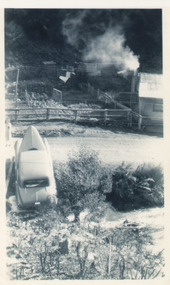
... Operations at the site were revived in 2016 and the A1 Mine is now considered one of Victoria's premier gold mines. The A1 mine is part of the extensive and prospective Lachlan Fold Belt, a north-west trending belt of tightly folded Early Devonian sedimentary rocks extending from New South Wales to Victoria. ...Operations at the site were revived in 2016 and the A1 Mine is now considered one of Victoria's premier gold mines. The A1 mine is part of the extensive and prospective Lachlan Fold Belt, a north-west trending belt of tightly folded Early Devonian sedimentary rocks extending from New South Wales to Victoria. ...The A1 Gold Mine is located north of Woods Point, near Jamieson, in the Upper Goulburn region of Victoria. Gold was discovered at the A1 site in 1861 and mining operations began in 1864. The A1 Mine Settlement refers to a small township known variously as Castle Reef, Castle Point, and Raspberry Creek, which developed in the 1860s around mining industry centred on a crushing machine that worked the three gold reefs in the area. Historically, the name "A1"referred to the high quality of gold found in the quartz reefs at depths of at least two thousand feet. Along with the Morning Star mine at Woods Point, the A1 gold mine produced almost sixty percent of Victoria's gold output in the 1950s to 1970s and continued operating until 1992 when it went into administration. Operations at the site were revived in 2016 and the A1 Mine is now considered one of Victoria's premier gold mines. The A1 mine is part of the extensive and prospective Lachlan Fold Belt, a north-west trending belt of tightly folded Early Devonian sedimentary rocks extending from New South Wales to Victoria. Mineralisation is hosted within or immediately adjacent to diorite dykes. Contemporary development of the 'Queens Lode' at the A1 mine signals a move from high-grade, narrow vein airleg mining into larger scale, mechanical mining designed to increase ore production volume. This original, undated photograph of the A1 Mine appears to depict an area or phase of disuse or abandonment. The aged and humble appearance of the cottage suggests association with the historical A1 Mine Settlement, therefore the image may have been taken prior to the 1950s-1970s revival period in which the A1 mine is known to have produced high gold yields. The photograph contributes to our understanding of the A1 Gold Mine's impact on the landscape and the social, environmental impacts of mining on communities and may be compared with others in the Burke Museum's extensive collection of mining photographs to deepen our understanding of mining in the Jamieson area.Black and white rectangular photograph printed on photographic paperReverse: 5577 / A1 Mine / Near Jamieson / Vic. /burke museum, beechworth museum, beechworth, gold fields, gold rush, victorian gold rush, mining tunnels, gold ming history, colonial australia, australian gold rushes, mining technology, beechworth historic district, indigo gold trail, indigo shire, upper goulburn shire, jamieson, woods point-walhalla goldfield, a1 gold mine, victorian high country, modern mining methods, orogenic gold province, gold mineralisation, devonian, dykes -
 Eltham District Historical Society Inc
Photograph, The Rose Stereograph Company, Log Bridge, Eltham Road. Greensborough, c.1920
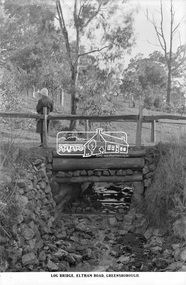
... west to the north east, possibly feeding into the Karingal Yalloc, somewhere near presenet day Ramptons Road Reserve. This glass plate negative was used to manufacture postcards (1:1 printing) for commercial sale by the Rose Sterograph Company and its subsidiaries. George Rose founded the Rose Stereograph Company in 1880 and was joined by Herbert (Bert) Cutts in the early 20th Century. The pair formed a lifetime working partnership and strong personal friendship. Assisted by George’s two sons, Herbert George and Walter, and later by Neil Cutts, the Rose Stereograph Company continued its operations...west to the north east, possibly feeding into the Karingal Yalloc, somewhere near presenet day Ramptons Road Reserve. This glass plate negative was used to manufacture postcards (1:1 printing) for commercial sale by the Rose Sterograph Company and its subsidiaries. George Rose founded the Rose Stereograph Company in 1880 and was joined by Herbert (Bert) Cutts in the early 20th Century. The pair formed a lifetime working partnership and strong personal friendship. Assisted by George’s two sons, Herbert George and Walter, and later by Neil Cutts, the Rose Stereograph Company continued its operations ...A woman stands at the end of a log bridge over a creek looking towards the south along the unsealed roadway. The sun illuminates her back. She is wearing a woollen knit beanie with edges rolled up, dark jacket and skirt, full length dark stockings and slip on dark leather shoes with raised heel, typical of the early 1920s. The creek is possibly feeding into the Karingal Yalloc. The direction of the road based on shadows is northwest as is the Eltham Road to Greensborough (present day Sherbourne, Karingal and St Helena roads). The creek is falling to the foreground so from south west to the north east, possibly feeding into the Karingal Yalloc, somewhere near presenet day Ramptons Road Reserve. This glass plate negative was used to manufacture postcards (1:1 printing) for commercial sale by the Rose Sterograph Company and its subsidiaries. George Rose founded the Rose Stereograph Company in 1880 and was joined by Herbert (Bert) Cutts in the early 20th Century. The pair formed a lifetime working partnership and strong personal friendship. Assisted by George’s two sons, Herbert George and Walter, and later by Neil Cutts, the Rose Stereograph Company continued its operations for more than 140 years. The company was initially built on stereographs, but as cinema took over and stereographs fell out of fashion, the Rose Stereograph Company developed Australia’s first commercially viable photographic postcard business. Specialising in postcards of iconic historical moments and significant landmarks, The Rose Stereograph Company became a staple of the Australian travel industry.This remarkable collection of glass plate negatives, transparencies, and postcards – arguably Australia’s most significant photography collection outside of public hands – has been passed down through the generations, surviving war, relocation, and the harsh Victorian climate. The historic Rose Stereograph collection is the culmination of George Rose’s dream of capturing and preserving precious moments in time and remains the legacy of the Rose and Cutts families. It is with great sadness that the Cutts family says goodbye to a collection that spans five generations and 140 years. The Cutts family understands that for these historically important pieces to rest with one family is to deny others the pleasure of their custodianship.Glass Plate Negative Size: 9.2 x 13.8 cmLog Bridge, Eltham Road, Greensborougheltham, postcard, travel, rose stereograph company, glass plate negative, creek, eltham road, greensborough, karingal road, karingal yallock, log bridge, sherbourne road, st helena road, women's fashion, rampton's road reserve, peter and elizabeth pidgeon collection -
 Monbulk RSL Sub Branch
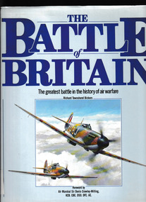
Book, Salamander Books, The Battle of Britain: The greatest battle in the history warfare, 1990
... Monbulk RSL Sub Branch 48 Main Road Monbulk yarra-valley-and-the-dandenong-ranges World War 1939-1945 - Aerial operations - Britain Battle of Britain By the summer of 1940, the overwhelming might of the German air force had triumphed over Poland, Norway, France, Holland and Belgium. As the fighters and bombers of the Luftwaffe amassed on the north west ...By the summer of 1940, the overwhelming might of the German air force had triumphed over Poland, Norway, France, Holland and Belgium. As the fighters and bombers of the Luftwaffe amassed on the north west coast of Europe, they had no reason to believe that the heavily outnumbered squadrons of the Royal Air Force (RAF) would prove any more difficult to overcome than their earlier opponents. However, these illusions of invulnerability were soon to be shattered in whirling combats over southern England in the conflict that would be known as the Battle of Britain.Index, ill, maps, p.193.non-fictionBy the summer of 1940, the overwhelming might of the German air force had triumphed over Poland, Norway, France, Holland and Belgium. As the fighters and bombers of the Luftwaffe amassed on the north west coast of Europe, they had no reason to believe that the heavily outnumbered squadrons of the Royal Air Force (RAF) would prove any more difficult to overcome than their earlier opponents. However, these illusions of invulnerability were soon to be shattered in whirling combats over southern England in the conflict that would be known as the Battle of Britain.world war 1939-1945 - aerial operations - britain, battle of britain -
 Monbulk RSL Sub Branch
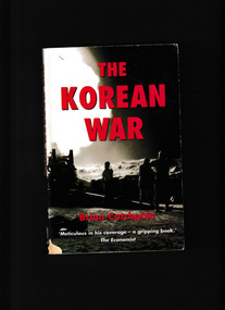
Book, Robinson, The Korean War, 1950-53, 2001
... Monbulk RSL Sub Branch 48 Main Road Monbulk yarra-valley-and-the-dandenong-ranges Korea - History Korean war 1950-1953 - History This book] recounts the military operations: the slogging war on the ground as well as the U.N. naval superiority and the importance of air power. He also explains the diplomatic background of international relations between China and the West, the communist propaganda in the north, the issue of prisoners-of-war, the talks leading to the armistice and the creation of the demilitarized zone Index, bib, ill, maps, p.386. ...This book] recounts the military operations: the slogging war on the ground as well as the U.N. naval superiority and the importance of air power. He also explains the diplomatic background of international relations between China and the West, the communist propaganda in the north, the issue of prisoners-of-war, the talks leading to the armistice and the creation of the demilitarized zoneIndex, bib, ill, maps, p.386.non-fictionThis book] recounts the military operations: the slogging war on the ground as well as the U.N. naval superiority and the importance of air power. He also explains the diplomatic background of international relations between China and the West, the communist propaganda in the north, the issue of prisoners-of-war, the talks leading to the armistice and the creation of the demilitarized zonekorea - history, korean war 1950-1953 - history -
 Bendigo Historical Society Inc.
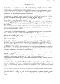
Document - ALBERT RICHARDSON COLLECTION: THE PEARL MINE
... Typed, 2 page document, detailing the location and history of the operation of the Pearl Mine. The mine was located approximately 2 miles north west from the Bendigo Post Office. ...History House 11 Mackenzie Street Bendigo goldfields BENDIGO Mining pearl company mine Typed, 2 page document, detailing the location and history of the operation of the Pearl Mine. The mine was located approximately 2 miles north west from the Bendigo Post Office. ...Typed, 2 page document, detailing the location and history of the operation of the Pearl Mine. The mine was located approximately 2 miles north west from the Bendigo Post Office. The main shaft was put down to 1613 feet and 3 subsidiary shafts were sunk, Information is given about the south shaft, originally the main shaft of the Great Extended Hercules and the east shaft, which was situated on the Sheepshead line.bendigo, mining, pearl company mine -
 Bendigo Historical Society Inc.
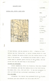
Document - ALBERT RICHARDSON COLLECTION: CENTRAL RED, WHITE AND BLUE MINE
... The location of the Central Red, White and Blue mine was on the north-west corner of Barnard and Honeysuckle Streets, Golden Square. The mine was formed in 1910 and ceased operations in 1936. ...The location of the Central Red, White and Blue mine was on the north-west corner of Barnard and Honeysuckle Streets, Golden Square. The mine was formed in 1910 and ceased operations in 1936. ...Two-page typed document plus location map. The location of the Central Red, White and Blue mine was on the north-west corner of Barnard and Honeysuckle Streets, Golden Square. The mine was formed in 1910 and ceased operations in 1936. Features of the mine are described: the winding engine, boilers, air compressor, poppet legs, engine house, crushing battery, gold produced and where obtained from. 'The rich gold yields which made this mine so prominent in its early years, was obtained from a large reef at the 318 feet level, some yields reached as high as 15 oz to the ton'.bendigo, mining, central red, white & blue mine -
 Otway Districts Historical Society
Photograph, Brucker, Powneys Cutting being excavated, c.1902, c.1902
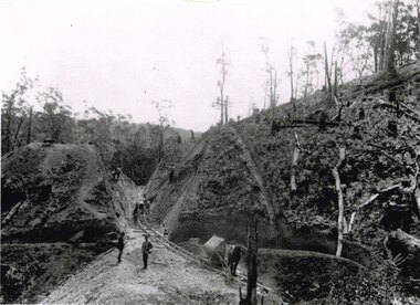
... north-west. Jim Facey and Jim, Ted and Tom Cashin formed a partnership to log an area along the Charley's Creek Road six kilometres from Ferguson, operating full-time from 1934. After leasing three Crown sites and cutting them out the partners shifted logging operations...north-west. Jim Facey and Jim, Ted and Tom Cashin formed a partnership to log an area along the Charley's Creek Road six kilometres from Ferguson, operating full-time from 1934. After leasing three Crown sites and cutting them out the partners shifted logging operations ...Because of the vast quantity of piles for harbour works Pettit Bros. of Geelong arranged for an addition siding to be installed at Ferguson on the north side of the station in 1913. They then laid a tramway in a northerly direction along the original alignment of Charley's Creek road to the top of Powneys Cutting, 1.8 km from Ferguson, where a log winch was sited. This powerful winch hauled carefully selected piles from the north-west. Jim Facey and Jim, Ted and Tom Cashin formed a partnership to log an area along the Charley's Creek Road six kilometres from Ferguson, operating full-time from 1934. After leasing three Crown sites and cutting them out the partners shifted logging operations to Powneys farm, which they had purchased, and laid a log trail into the farm. The old road reserve was also purchased, and the log tram continued along the road reserve for one kilometre to Powneys Cutting. Logs were winched up to the tramline and despatched to the mill along the falling grade of the road.B/W. 201mm x 268mm. Powneys Cutting being excavated by four men, two men on either side of the slope, and a horse at the end of the line, in c.1902.ferguson; powneys cutting; tramways; powneys farm; pettit; jim facey; jim cashin; ted cashin; tom cashin; charley's creek road; -
Port Melbourne Historical & Preservation Society
Document - Brochure, West Gate Bridge Progress Report, 1977 - 1979
... Port Melbourne Historical & Preservation Society Port Melbourne Town Hall 333 Bay Street Port Melbourne melbourne Engineering - Bridges Local Government - City of Port Melbourne Industry - Manufacturing Built Environment - Recreational Facilities Built Environment - Industrial Lower Yarra Crossing Authority Claude BUTCHER Jack ANDERSON City of Port Melbourne - Electricity Supply Department J Kitchen & Sons Pty Ltd West Gate Bridge Port Melbourne Cricket Ground North Port Oval .03 - West Gate Bridge Progress Report: August 1977 - large 4pp brochure detailing main span construction and Operations centre West Gate Bridge Progress Report Document Brochure ....03 - West Gate Bridge Progress Report: August 1977 - large 4pp brochure detailing main span construction and Operations centre engineering - bridges, local government - city of port melbourne, industry - manufacturing, built environment - recreational facilities, built environment - industrial, lower yarra crossing authority, claude butcher, jack anderson, city of port melbourne - electricity supply department, j kitchen & sons pty ltd, west gate bridge, port melbourne cricket ground, north port oval -
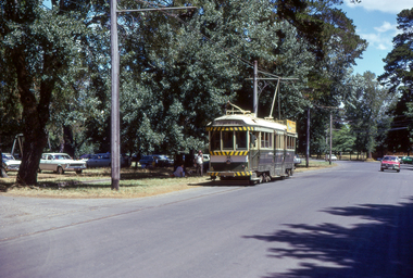 Ballarat Tramway Museum
Photograph - Digital Image - first public day - tram 38 Wendouree Parade, Paul Nicholson, 26-12-1974
... Photo of SECV/BTPS tram No. 38 in Wendouree Parade near Windmill Drive North on the first day of public operations by the Ballarat Tramway Preservation Society - Boxing Day 1974. Photo by Paul Nicholson. Tram is showing the destination of Gardens via Sturt St West, before the blinds were extended for Cartlon St and St Aidan Drive....Ballarat Tramway Museum South Gardens Reserve Wendouree Parade Ballarat Ballarat goldfields Photo of SECV/BTPS tram No. 38 in Wendouree Parade near Windmill Drive North on the first day of public operations by the Ballarat Tramway Preservation Society - Boxing Day 1974. Photo by Paul Nicholson. Tram is showing the destination of Gardens via Sturt St West, before the blinds were extended for Cartlon St and St Aidan Drive. ...Photo of SECV/BTPS tram No. 38 in Wendouree Parade near Windmill Drive North on the first day of public operations by the Ballarat Tramway Preservation Society - Boxing Day 1974. Photo by Paul Nicholson. Tram is showing the destination of Gardens via Sturt St West, before the blinds were extended for Cartlon St and St Aidan Drive.Yields information about the first day of public tram operations on 26-12-1974 by the BTPSDigital image of a colour slide.tramcars, tramways, btps, wendouree parade, tram 38 -
 Ballarat Tramway Museum
Slide - Set of 9, Warren Doubleday, Ballarat - last weekday of full operations, 20/8/1971
... Has the tram stop shelter in the view. 6 - tram 39 climbing the Lydiard St North hill. 7 - tram 32 in bound in Sturt St west passing a 40mph speed limit sign. 8 - trams 21 and 34 crossing at the Grant St loop on the Mt Pleasant line. 9 - tram 37 inbound in Lydiard St North with the Ballarat Station building in the background and the signal gantry. Yields information about the last full week day of SEC Tramway operations ...Photos taken on the last weekday of full operations by the SECV in Ballarat prior to the first closure of the Victoria St line on 22/8/1971. 1 - trams 33, 13, 30, and 12 in the City loop. Has the Dickins food store, Thomas Jewellers, Gear Chemist, Patersons stores in the view. 2 - tram 37 running a Special passing the trams above in the City Loop. Also has the Hartley's and the T& G buildings in the view. 3 - tram 27 descending the Lydiard St hill about to pass the Titanic Bandstand. 4 - tram 35 turns from Sturt St into Lydiard St north with the Town Hall in the background. 5 - tram 27, Victoria St inbound in Wendouree Parade near Haddon St. Has the tram stop shelter in the view. 6 - tram 39 climbing the Lydiard St North hill. 7 - tram 32 in bound in Sturt St west passing a 40mph speed limit sign. 8 - trams 21 and 34 crossing at the Grant St loop on the Mt Pleasant line. 9 - tram 37 inbound in Lydiard St North with the Ballarat Station building in the background and the signal gantry.Yields information about the last full week day of SEC Tramway operations in Ballarat and has a strong association with the archivist. Set of 9 Kodachrome colour slides - cardboard mountsHave the photographer's slide numbers written on them.trams, tramways, closure, sturt st, lydiard st, tram 13, tram 30, tram 12, tram 37, tram 43 -
 Ballarat Tramway Museum
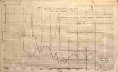
Administrative record - Set of 18 Ballarat - Passenger graphs, State Electricity Commission of Victoria (SECV), 1956 - 1957
... Set of 18 graphs showing route, date, passenger numbers by time: 1 - Gardens via Sturt St West - Sunday 5-2-1956 2 - Gardens via Drummond St North - Sunday 5-2-1956 3 - Victoria St - Sunday 5-2-1956 4 - Mt Pleasant - Sunday 5-2-1956 5 - Gardens via Sturt St West - Sunday 26-8-1956 6 - Gardens via Drummond St North - Sunday 26-8-1956 7 - Victoria St - Sunday 26-8-1956 8 - Mt Pleasant - Sunday 26-8-1956 9 - Lydiard St Nth - Sebastopol - Sunday - August 1956 10 - ditto - Feb. 1956 11 - Sunday Operation - average no. of passengers carried all routes, Sundays Nov. 1955 to Oct. 1956 12 - Sebastopol route - Sunday 6-1-1957 13 - Lydiard St Nth route - Sunday 6-1-1957 14 - Gardens via Sturt St West - Sunday 6-1-1957 15 - Gardens via Drummond St Nth - Sunday 6-1-57 16 - Victoria St - Sunday 6-1-1957 17 - Mt Pleasant - Sunday 6-1-1957 18 - Average Number of passengers per trip - Sunday 6-1-1957 ...Ballarat Tramway Museum South Gardens Reserve Wendouree Parade Ballarat Ballarat goldfields Set of 18 graphs showing route, date, passenger numbers by time: 1 - Gardens via Sturt St West - Sunday 5-2-1956 2 - Gardens via Drummond St North - Sunday 5-2-1956 3 - Victoria St - Sunday 5-2-1956 4 - Mt Pleasant - Sunday 5-2-1956 5 - Gardens via Sturt St West - Sunday 26-8-1956 6 - Gardens via Drummond St North - Sunday 26-8-1956 7 - Victoria St - Sunday 26-8-1956 8 - Mt Pleasant - Sunday 26-8-1956 9 - Lydiard St Nth - Sebastopol - Sunday - August 1956 10 - ditto - Feb. 1956 11 - Sunday Operation - average no. of passengers carried all routes, Sundays Nov. 1955 to Oct. 1956 12 - Sebastopol route - Sunday 6-1-1957 13 - Lydiard St Nth route - Sunday 6-1-1957 14 - Gardens via Sturt St West - Sunday 6-1-1957 15 - Gardens via Drummond St Nth - Sunday 6-1-57 16 - Victoria St - Sunday 6-1-1957 17 - Mt Pleasant - Sunday 6-1-1957 18 - Average Number of passengers per trip - Sunday 6-1-1957 Demonstrates the SECV Ballarat office work to understand Sunday passenger numbers. ...Set of 18 graphs showing route, date, passenger numbers by time: 1 - Gardens via Sturt St West - Sunday 5-2-1956 2 - Gardens via Drummond St North - Sunday 5-2-1956 3 - Victoria St - Sunday 5-2-1956 4 - Mt Pleasant - Sunday 5-2-1956 5 - Gardens via Sturt St West - Sunday 26-8-1956 6 - Gardens via Drummond St North - Sunday 26-8-1956 7 - Victoria St - Sunday 26-8-1956 8 - Mt Pleasant - Sunday 26-8-1956 9 - Lydiard St Nth - Sebastopol - Sunday - August 1956 10 - ditto - Feb. 1956 11 - Sunday Operation - average no. of passengers carried all routes, Sundays Nov. 1955 to Oct. 1956 12 - Sebastopol route - Sunday 6-1-1957 13 - Lydiard St Nth route - Sunday 6-1-1957 14 - Gardens via Sturt St West - Sunday 6-1-1957 15 - Gardens via Drummond St Nth - Sunday 6-1-57 16 - Victoria St - Sunday 6-1-1957 17 - Mt Pleasant - Sunday 6-1-1957 18 - Average Number of passengers per trip - Sunday 6-1-1957 Demonstrates the SECV Ballarat office work to understand Sunday passenger numbers. May have been part of a move to consider ceasing operations on Sundays.Printed graphs on foolscap paper set of 18.All have the SEC Drawing Office stamp and dated on the rear.tramways, statistics, passenger services, reports, ballarat, sunday services -
 Ballarat Tramway Museum
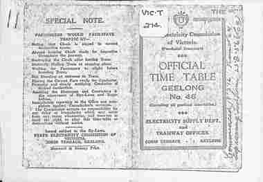
Ephemera - Photocopy, State Electricity Commission of Victoria (SECV), "Official Time Table Geelong No. 46", c1951
... West Geelong, East Geelong, Chilwell, Eastern Park, Belmont and North lines. Note: Sheets may not be in the same order as the printed versions due to the photocopying method. See items 5357 and 5629 and 8552 for other versions. Yields information about the operation ...Photocopy of the Geelong Timetable, No. 46, c1951 giving details of the fares, transfers, luggage or parcels, lost property, times of each tram on the Newtown, West Geelong, East Geelong, Chilwell, Eastern Park, Belmont and North lines. Note: Sheets may not be in the same order as the printed versions due to the photocopying method. See items 5357 and 5629 and 8552 for other versions. Yields information about the operation of the Geelong tramway system.Photocopy - 17 A4 sheets of the "Official Time Table Geelong No. 46" on heat sensitive paper.tramways, trams, geelong, timetable, operations