Showing 43 items matching "orchard avenue"
-
 Ringwood and District Historical Society
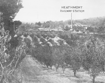
Photograph, View from Herman Pump's orchard, Heathmont near Royal Avenue. Looking towards Bedford Rd. and Ringwood (undated)
... View from Herman Pump's orchard, Heathmont near Royal Avenue. Looking towards Bedford Rd. and Ringwood (undated)...Typed below photograph, "View from Herman Pump's orchard, Heathmont near Royal Avenue. Looking towards Bedford Rd. and Ringwood. ...View from Herman Pump's orchard, Heathmont near Royal Avenue. Looking towards Bedford Rd. and Ringwood (undated) Photograph ...Typed below photograph, "View from Herman Pump's orchard, Heathmont near Royal Avenue. Looking towards Bedford Rd. and Ringwood. Loughnans Hill in background to left of centre." -
 Eltham District Historical Society Inc
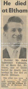
Newspaper - News Clipping, Herald, He died at Eltham. Herald, March 4, p3, 4 Mar 1965
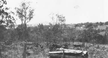
... ...Orchard Avenue...Frank was asked to assist with the removal of three bodies from the back gully (now Orchard Avenue). They were badly burnt and one was found stuck under a fence as though trying to escape. ...Frank was asked to assist with the removal of three bodies from the back gully (now Orchard Avenue). They were badly burnt and one was found stuck under a fence as though trying to escape. ...John Lawrence Coleman (1934-1965) born January 10, was the son of Raymond John Coleman and Hanna May (Gillet) Coleman. He married Margaret Frances Dare in 1955 and was the father of two children. He died whilst attempting to rescue an older man trapped in the bushfire at North Eltham on March 3, 1965 He died at Eltham (Herald, 4 March 1965, p3) [Picture of John Lawrence Coleman] Builder Mr John Lawrence Coleman, 31, of Main Rd., Eltham, one of three men burnt to death yesterday in the fire at North Eltham. The other two were XXXXX, 33 who lives opposite the Colemans and Mr William Elwers, 64 of Batman Rd., Eltham. * * * Frank Martin was a volunteer with the Eltham rural fire brigade at the time of the 1965 bushfires which burnt Eltham North and Research. Frank was asked to assist with the removal of three bodies from the back gully (now Orchard Avenue). They were badly burnt and one was found stuck under a fence as though trying to escape. Volunteers John Coleman Jnr, William Elwers and George Crowe were killed trying to protect Eltham from bushfire – they were local heroes. At the time, John Coleman Jnr was survived by his wife Margaret and two young children – John 11 and Vicky 2. Margaret Coleman lived in the family home until 1992 when she sold it and moved to Tasmania to be close to her son. She died in 1997 aged 65 years. 75 yr old Ken Gaston grew up on Edendale farm, which was originally a poultry farm but is now owned and run by the Shire of Nillumbik as an educational farm for schools and visitors. He was Captain of the Eltham rural fire brigade in 1965 when John Coleman Jnr was burnt to death in the Eltham North bushfires serving as an unofficial volunteer. He was able to draw where the original Wattletree Road was and at the time was verified with the location of some remaining bitumen and a post from the original bridge over the Diamond Creek located near the junction of the Diamond Creek and another small creek which is further down from Research or Christmas Creek as locals refer to it. The original Main Road ran behind Colemans before the railway line was built beyond Eltham in 1912. (Information recorded by Harry Gilham, President EDHS c.2011) * * * Bushfires rage in Victoria, Snowy: Three dead (1965, March 4). The Canberra Times (ACT : 1926 - 1995), p. 1. Retrieved May 19, 2022, from http://nla.gov.au/nla.news-article131758981 Includes two photos of the fire in North Eltham “Firemen make for safety as fire rages in Upper Glen Park Road, North Eltham, Victoria. The smoke hides a house.” and “A house explodes into flames at North Eltham, Victoria. Firemen said bottled gas went up.” Canberra Times (ACT : 1926 - 1995), Thursday 4 March 1965, page 1 ________________________________________ Firemen make for safety as fire rages in Upper Glen Park Road. North Eltham. Victoria. The smoke hides a house. A house explodes into flames at North Eltham. Victoria. Firemen said bottled gas went up. Bushfires rage in Victoria, Snowy: Three dead MELBOURNE, Wednesday.—Three people died today in a bush» fire which raged through North Eltham, about 15 miles from Melbourne. The victims were three men. A fourth man is feared to be dead. Another bushfire. sparked off by the heatwave sizzling over south-eastern Australia, is burning out of control in the Kosciusko State Park, in the Snowy Mountains. Firefighters fear that if it reaches pine forests up the Yarrangobilly River, they will be powerless to stop it. The three victims of the North Eltbam fire were trapped by flames in a valley. Their bodies were found only a few yards apart. They were named by police tonight as Mr. George Crowe, 78, of North Eltham, William John Ewers, 64, and John Laurence Coleman, 31, both of Eltham. The other two have not been identified. They are believed to be a man aged about 40 and an 18-year-old youth. At least 12 homes were destroyed by the fire, the worst in Victoria since 1962, when eight lives were lost and hundreds of homes burnt down at Warrandyte. At one time the township of Eltham was threatened, but a cool change swept in from the south and held back the wall of flames. More than 100 dogs, worth about £4,000, died when the fire raced through two kennels in Short Street, Eltham. and Upper Glen Park Road, North Eltham. A trickle of water Residents ran into the streets as the blaze raced towards their houses. Others frantically dug firebreaks around their homes. Mrs. Sue Recourt wept when firemen arrived while she was vainly trying to stop the flames with a trickle of water from the garden hose. A stack of firewood was blazing, but the firemen managed to save the house and rescue four goats. Many homes in Eltham were saved after flames had crept to within feet of their fences. Students at North Eltham State School had to be evacuated when the blaze threatened the building. Fire fighters were severely hampered by lack of water and narrow roads. The blaze, which began in above century heat, turned toward Wattle Glen, where two houses were gutted. Then the flames raced towards Hurstbridge to the north. Firemen battling desperately, controlled the fire late this afternoon. Five forest fires were still burning in Victoria tonight. IN VICTORIA THIS WEEK Tragic lack of central fire authority (1965, March 9). The Canberra Times (ACT : 1926 - 1995), p. 2. Retrieved May 19, 2022, from http://nla.gov.au/nla.news-article131759928 Canberra Times (ACT : 1926 - 1995), Tuesday 9 March 1965, page 2 ________________________________________ IN VICTORIA THIS WEEK Tragic lack of central fire authority From Rohan Rivett It was the worst week for Victorian fire fighters since Black Friday 27 years ago. On that day one pilot up in a spotter plane said afterwards: "It seemed at times that half the State was on fire." This time, for three days on end, Gippsland men, women and children had moments of conviction that their towns would have blackened into anonymity before the weekend was out. The week began with horror at Eltham on the North-eastern edge of Melbourne. Eltham today is something of an artists' colony. Oil painters, water colourists, potters and sculptors proliferate. A number of University folk have emulated the example of Professor MacMahon Ball who pioneered the way by moving to Eltham and carving a home out of the bush in the thirties. Innermost Eltham is barely 14 miles from the G.P.O. Farthest Eltham stretches miles beyond. It served to illustrate the tragi-ludicrous truncation of Victoria's fire control. Part of Eltham is under the protection of the Melbourne Fire Brigade. But this responsibility ceases at some invisible and incomprehensible line — apparently determined by the meanderings of the water mains. At this point everybody's property throughout the rest of Eltham is dependent on the Country Fire Authority. Half an hour before midday on Wednesday, a fire suddenly started on the West side of Upper Glen road on the edge of Eltham. Before the fire brigade could arrive, it was burning on a widening front through timber and high grass north of Eltham. Two wind changes in rapid succession saw the fire leaping Diamond Creek. With a freshening wind it struck home after home in three streets. More than one of them exploded suddenly as if hit by an incendiary bomb. There is no piped gas in the Eltham area, hence many housewives use bottle gas. The flames outside caused the bottles to explode. Altogether twelve homes were completely incinerated and four more were badly damaged. Thirty prize dogs perished. About three hours after the fire started it raced suddenly down a gully hillside trapping an elderly man. Two other men apparently raced to the rescue. Flames caught the three men within yards of each other, not 200 yards off the Upper Glen Park Road where safety lay. They were burned to death. Next evening an angry and convincing secretary of the Fire Brigade Union, Mr. W. M. Webber, came on television and appealed to the people of Victoria to end the ridiculous and dangerous dualism in fire-fighting control. The Eltham fire, he said, had precisely illustrated the situation. The Metropolitan Fire Brigade area touched Eltham, but where the fire had gutted and killed, was just outside its area. Mr. Webber said his union had constantly urged one authority for the State with a complete reorganisation of fire protection. On Wednesday the union had repeated its call for an inquiry into fire protection in Victoria to the Chief Secretary, Mr Rylah. "No matter how close the liaison between the two organisations, there are always divided sections of thinking," Mr. Webber told viewers. "I don't know how much tragedy the com-munity can take before it demands that it is properly protected." Rumours that differences in gauge between taps and hose nozzles (as between the two authorities) accentuated the damage were denied by fire chiefs who said that all appliances were now carrying adaptors so that hoses could be linked to mains everywhere. But there is grave concern in the Metropolitan Fire Brigade's higher councils at the action of several Federal authorities with projects in and around Melbourne. They are installing non-standard equipment without reference to the State authorities or any dovetailing of appliances and equipment. Public alarm was not diminished by the publication on Friday and Saturday of a heart tearing letter from the young widow of John Lawrence Coleman, 31 year old father of two, who had died in the flames apparently trying to rescue the old man trapped in the gully. By that time, a Vast area of Gippsland was in flames and the troops had been sent in to back up the overworked and often helpless fire-fighters. By Saturday, the Leader of the Opposition, Mr. Stoneham, who has previously demanded a Royal Commission into fire-fighting arrangements, repeated his demand. To add to the Chief Secretary's worries he was publicly rebuked for allegedly implying on television that lives had been lost at Eltham because people went to the wrong place at the wrong time. In a letter to the Press, Professor MacMahon Ball pointed out that two of the men involved were experienced bushmen who had gone "to help an old man in great danger fully aware of the danger to themselves". As Victoria faced its sixth day of total State-wide fire ban, it looked likely that even official resistance was not going to silence the demand for one central authority to control the fire fiend. At the moment, the 400 square miles where two million Victorians live in Greater Melbourne are divorced from the rest of the State in planning, communications, equipment and control of personnel. No one doubts the whole-hearted co-operation and willingness to back each other up of the M.F.B. and the C.F.A., both at top-level and among the firemen themselves. However, when a city straggles so deeply into the country side, the absence of a single authority, to oversee and analyse the fire threat as a whole, suggests suicidal policy of divide and fuel. Emphasis of the tragic loss of a member of a pioneering family who died whilst helping others in his communitybushfire, cfa, country fire authority, fire brigrade, glen park road, heroes, john lawrence coleman, north eltham, victorian bushfires - 1965, volunteers, william john elwers, fire fighter, frank martin, george john crowe, ken gaston, orchard avenue -
 Eltham District Historical Society Inc
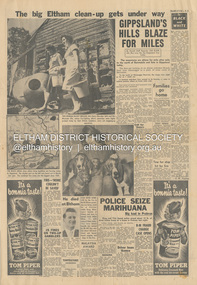
Newspaper - News Clipping, Herald, The big Eltham clean-up gets under way, Herald, 4 March, p3, 1965
... ...Orchard Avenue...Emphasis of the tragic loss of a member of a pioneering family who died whilst helping others in his community Bushfire cfa country fire authority Fire Brigrade Glen Park Road Heroes John Lawrence Coleman North Eltham Victorian Bushfires - 1965 Volunteers William John Elwers Fire Fighter Frank Martin George John Crowe Ken Gaston Orchard Avenue Doug Mummery Helen Oliver Mrs Henry Marsden Mrs Moureen Ellis Newsprint The big Eltham clean-up gets under way, Herald, 4 March, p3 Newspaper News Clipping Herald ...Full page newspaper clipping featuring the March 1965 Victorian bushfires. Items include: Photograph - TWO-WOMAN BUCKET BRIGADE, Mrs Henry Marsden (left) and Mrs Moureen Ellis, whose fire-fighting efforts yesterday were highly praised today by their Eltham neighbours, carry out mopping-up operations Photograph - DOGS MADE HOMELESS by the fire in North Eltham yesterday are being cared for at First-Constable Doug. Mummery's kennels at Eltham and here is kennel maid Helen Oliver, 17, with some of them today. The two basset hounds are owned by Mr Bill Guy who lost about 100 daschund and basset hound puppies and dogs in the fire. Photograph - He died at Eltham [Picture of John Lawrence Coleman] Builder Mr John Lawrence Coleman, 31, of Main Rd., Eltham, one of three men burnt to death yesterday in the fire at North Eltham. The other two were XXXXX, 33 who lives opposite the Colemans and Mr William Elwers, 64 of Batman Rd., Eltham. John Lawrence Coleman (1934-1965) born January 10, was the son of Raymond John Coleman and Hanna May (Gillet) Coleman. He married Margaret Frances Dare in 1955 and was the father of two children. He died whilst attempting to rescue an older man trapped in the bushfire at North Eltham on March 3, 1965 Other news stories of the day: Bushfires rage in Victoria, Snowy: Three dead (1965, March 4). The Canberra Times (ACT : 1926 - 1995), p. 1. Retrieved May 19, 2022, from http://nla.gov.au/nla.news-article131758981 Includes two photos of the fire in North Eltham “Firemen make for safety as fire rages in Upper Glen Park Road, North Eltham, Victoria. The smoke hides a house.” and “A house explodes into flames at North Eltham, Victoria. Firemen said bottled gas went up.” Canberra Times (ACT : 1926 - 1995), Thursday 4 March 1965, page 1 ________________________________________ Firemen make for safety as fire rages in Upper Glen Park Road. North Eltham. Victoria. The smoke hides a house. A house explodes into flames at North Eltham. Victoria. Firemen said bottled gas went up. Bushfires rage in Victoria, Snowy: Three dead MELBOURNE, Wednesday.—Three people died today in a bush» fire which raged through North Eltham, about 15 miles from Melbourne. The victims were three men. A fourth man is feared to be dead. Another bushfire. sparked off by the heatwave sizzling over south-eastern Australia, is burning out of control in the Kosciusko State Park, in the Snowy Mountains. Firefighters fear that if it reaches pine forests up the Yarrangobilly River, they will be powerless to stop it. The three victims of the North Eltbam fire were trapped by flames in a valley. Their bodies were found only a few yards apart. They were named by police tonight as Mr. George Crowe, 78, of North Eltham, William John Ewers, 64, and John Laurence Coleman, 31, both of Eltham. The other two have not been identified. They are believed to be a man aged about 40 and an 18-year-old youth. At least 12 homes were destroyed by the fire, the worst in Victoria since 1962, when eight lives were lost and hundreds of homes burnt down at Warrandyte. At one time the township of Eltham was threatened, but a cool change swept in from the south and held back the wall of flames. More than 100 dogs, worth about £4,000, died when the fire raced through two kennels in Short Street, Eltham. and Upper Glen Park Road, North Eltham. A trickle of water Residents ran into the streets as the blaze raced towards their houses. Others frantically dug firebreaks around their homes. Mrs. Sue Recourt wept when firemen arrived while she was vainly trying to stop the flames with a trickle of water from the garden hose. A stack of firewood was blazing, but the firemen managed to save the house and rescue four goats. Many homes in Eltham were saved after flames had crept to within feet of their fences. Students at North Eltham State School had to be evacuated when the blaze threatened the building. Fire fighters were severely hampered by lack of water and narrow roads. The blaze, which began in above century heat, turned toward Wattle Glen, where two houses were gutted. Then the flames raced towards Hurstbridge to the north. Firemen battling desperately, controlled the fire late this afternoon. Five forest fires were still burning in Victoria tonight. IN VICTORIA THIS WEEK Tragic lack of central fire authority (1965, March 9). The Canberra Times (ACT : 1926 - 1995), p. 2. Retrieved May 19, 2022, from http://nla.gov.au/nla.news-article131759928 Canberra Times (ACT : 1926 - 1995), Tuesday 9 March 1965, page 2 ________________________________________ IN VICTORIA THIS WEEK Tragic lack of central fire authority From Rohan Rivett It was the worst week for Victorian fire fighters since Black Friday 27 years ago. On that day one pilot up in a spotter plane said afterwards: "It seemed at times that half the State was on fire." This time, for three days on end, Gippsland men, women and children had moments of conviction that their towns would have blackened into anonymity before the weekend was out. The week began with horror at Eltham on the North-eastern edge of Melbourne. Eltham today is something of an artists' colony. Oil painters, water colourists, potters and sculptors proliferate. A number of University folk have emulated the example of Professor MacMahon Ball who pioneered the way by moving to Eltham and carving a home out of the bush in the thirties. Innermost Eltham is barely 14 miles from the G.P.O. Farthest Eltham stretches miles beyond. It served to illustrate the tragi-ludicrous truncation of Victoria's fire control. Part of Eltham is under the protection of the Melbourne Fire Brigade. But this responsibility ceases at some invisible and incomprehensible line — apparently determined by the meanderings of the water mains. At this point everybody's property throughout the rest of Eltham is dependent on the Country Fire Authority. Half an hour before midday on Wednesday, a fire suddenly started on the West side of Upper Glen road on the edge of Eltham. Before the fire brigade could arrive, it was burning on a widening front through timber and high grass north of Eltham. Two wind changes in rapid succession saw the fire leaping Diamond Creek. With a freshening wind it struck home after home in three streets. More than one of them exploded suddenly as if hit by an incendiary bomb. There is no piped gas in the Eltham area, hence many housewives use bottle gas. The flames outside caused the bottles to explode. Altogether twelve homes were completely incinerated and four more were badly damaged. Thirty prize dogs perished. About three hours after the fire started it raced suddenly down a gully hillside trapping an elderly man. Two other men apparently raced to the rescue. Flames caught the three men within yards of each other, not 200 yards off the Upper Glen Park Road where safety lay. They were burned to death. Next evening an angry and convincing secretary of the Fire Brigade Union, Mr. W. M. Webber, came on television and appealed to the people of Victoria to end the ridiculous and dangerous dualism in fire-fighting control. The Eltham fire, he said, had precisely illustrated the situation. The Metropolitan Fire Brigade area touched Eltham, but where the fire had gutted and killed, was just outside its area. Mr. Webber said his union had constantly urged one authority for the State with a complete reorganisation of fire protection. On Wednesday the union had repeated its call for an inquiry into fire protection in Victoria to the Chief Secretary, Mr Rylah. "No matter how close the liaison between the two organisations, there are always divided sections of thinking," Mr. Webber told viewers. "I don't know how much tragedy the com-munity can take before it demands that it is properly protected." Rumours that differences in gauge between taps and hose nozzles (as between the two authorities) accentuated the damage were denied by fire chiefs who said that all appliances were now carrying adaptors so that hoses could be linked to mains everywhere. But there is grave concern in the Metropolitan Fire Brigade's higher councils at the action of several Federal authorities with projects in and around Melbourne. They are installing non-standard equipment without reference to the State authorities or any dovetailing of appliances and equipment. Public alarm was not diminished by the publication on Friday and Saturday of a heart tearing letter from the young widow of John Lawrence Coleman, 31 year old father of two, who had died in the flames apparently trying to rescue the old man trapped in the gully. By that time, a Vast area of Gippsland was in flames and the troops had been sent in to back up the overworked and often helpless fire-fighters. By Saturday, the Leader of the Opposition, Mr. Stoneham, who has previously demanded a Royal Commission into fire-fighting arrangements, repeated his demand. To add to the Chief Secretary's worries he was publicly rebuked for allegedly implying on television that lives had been lost at Eltham because people went to the wrong place at the wrong time. In a letter to the Press, Professor MacMahon Ball pointed out that two of the men involved were experienced bushmen who had gone "to help an old man in great danger fully aware of the danger to themselves". As Victoria faced its sixth day of total State-wide fire ban, it looked likely that even official resistance was not going to silence the demand for one central authority to control the fire fiend. At the moment, the 400 square miles where two million Victorians live in Greater Melbourne are divorced from the rest of the State in planning, communications, equipment and control of personnel. No one doubts the whole-hearted co-operation and willingness to back each other up of the M.F.B. and the C.F.A., both at top-level and among the firemen themselves. However, when a city straggles so deeply into the country side, the absence of a single authority, to oversee and analyse the fire threat as a whole, suggests suicidal policy of divide and fuel. Emphasis of the tragic loss of a member of a pioneering family who died whilst helping others in his communitybushfire, cfa, country fire authority, fire brigrade, glen park road, heroes, john lawrence coleman, north eltham, victorian bushfires - 1965, volunteers, william john elwers, fire fighter, frank martin, george john crowe, ken gaston, orchard avenue, doug mummery, helen oliver, mrs henry marsden, mrs moureen ellis -
 Eltham District Historical Society Inc
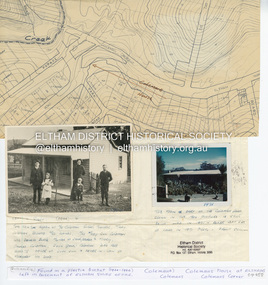
Document - Property Binder, 1203 Main Road, Eltham
... ...Orchard Avenue Eltham North...Main Road Eltham Property Houses Coleman House Coleman Crescent Mary Coleman Mary Dowes Mary Ann Coleman Mary Ann Burke Jack Coleman George Coleman John Coleman Jock Coleman Margaret Coleman Margaret Dare Dorothy Peatling Mrs Thomas Ken Gaston Frank Martin Vicky Weston Vicky Coleman Frank Burgoyne Heather Bakos Mrs Dansey Wattletree Road Edendale Farm Orchard Avenue Eltham North Diamond Creek Christmas Creek Cobb and Co Royal Mail Miscellaneous clippings, notes, photocopies, etc held on the subject property. 1203 Main Road, Eltham Document Property Binder ...Display panel: Map of Coleman's house location; 1904 photograph of Coleman house with Tom Newton, Mary Coleman (later Dowes) Mary Ann Coleman (nee Burke, mother of Jack Coleman, George Coleman, Mary Coleman), George Coleman, John (Jock) Coleman (father of John Coleman junior married to Margaret Coleman nee Dare); 1971 photograph of part of Coleman house. Typed document, compiled by Dorothy Peatling, Objection to Application 980731 Proposal for 6 units at 1203 Main Road Eltham, stories from Mrs Thomas, Ken Gaston, Frank Martin, Vicky Weston (nee Coleman), Frank Burgoyne, Heather Bakos, Mrs Dansey, and other historical information. Typed document, by Margaret Jennings, Objection to Application 980731 Proposal for 6 units at 1203 Main Road Eltham, history of site. Typed document, by Eltham District Historical Society, history of site, summary of interviews from Dorothy Peatling objection.main road, eltham, property, houses, coleman house, coleman crescent, mary coleman, mary dowes, mary ann coleman, mary ann burke, jack coleman, george coleman, john coleman, jock coleman, margaret coleman, margaret dare, dorothy peatling, mrs thomas, ken gaston, frank martin, vicky weston, vicky coleman, frank burgoyne, heather bakos, mrs dansey, wattletree road, edendale farm, orchard avenue eltham north, diamond creek, christmas creek, cobb and co royal mail -
 Mission to Seafarers Victoria
Photograph - Photograph, Sepia, Mr and Mrs Gurney Goldsmith, Picnic at Orchard House, Cup Day 1909, November 1909
... Gathering of seafarers and LHLG members, at Orchard House, Haverbrack Avenue, in Malvern on 2 November 1909. ...Mission to Seafarers Victoria 717 Flinders Street Docklands melbourne Gathering of seafarers and LHLG members, at Orchard House, Haverbrack Avenue, in Malvern on 2 November 1909. ...Gathering of seafarers and LHLG members, at Orchard House, Haverbrack Avenue, in Malvern on 2 November 1909. Mrs Beatrice Higgins, nee Shuter, was the secretary of the Malvern branch of the Guild since 2 July 1907.George Higgins, a graduate of the University of Melbourne, was a Lecturer in Surveying, Civil Engineering and Hydraulic Engineering 1907-1910 and in Civil Engineering 1911-1921 at that institution. The Shuters were supporters of the Mission. Mrs Charles Shuter gifted many items located in the chapel in memory of family members.Small monochrome photograph1909, malvern, cup day, orchard house, george higgins (c.1860-1943), charles shuter, picnics, social events, entertainments, beatrice elizabeth higgins (nee shuter), goldsmith album -
 Eltham District Historical Society Inc
Photograph - Digital Photograph, Alan King, Golden King Mine poppet-head, Yarrambat Primary School, 1 February 2008
... Avenue and Pioneer Road. Mines opposite Tanck’s Corner included Beer’s Line, Golden Crown and Golden Stairs. Some of the big mines had batteries and stampers to process quartz. At first there was plenty of alluvial gold, as much as two ounces to the ton. At times gold was exposed after heavy rains so fossickers panned for gold around orchard...Avenue and Pioneer Road. Mines opposite Tanck’s Corner included Beer’s Line, Golden Crown and Golden Stairs. Some of the big mines had batteries and stampers to process quartz. At first there was plenty of alluvial gold, as much as two ounces to the ton. At times gold was exposed after heavy rains so fossickers panned for gold around orchard ...The Golden King Mine poppet-head stands at the school’s Yan Yean Road exit gate. Published: Nillumbik Now and Then / Marguerite Marshall 2008; photographs Alan King with Marguerite Marshall.; p23 Early Yarambat - Tanck's Corner Its early settlers, who in the 1840s were amongst the first non-Aboriginal people in the area, found life tough as they grazed their sheep and cattle. Yarrambat was then known as Tanck’s Corner or Reynolds Corner, after wood carter, Frederick Tanck, who owned land north of Ironbark Road, at the corner of Yan Yean Road, and Thomas Reynolds, owner of the opposite property. After Reynolds sold his land, the corner became known as Tanck’s Corner. In 1929 the district’s name was changed to Yarrambat, believed to mean ‘high hill’ in the Wurundjeri language. Tanck’s Corner was in the centre of gold-bearing country and the district is honeycombed with old tunnels and shafts. However although gold played a dominant role for decades, there was insufficient to develop a substantial township. Meat and agricultural produce made a greater impact. Until the mid-20th century the only substantial building was the primary school. The first gold rush occurred around 1860, the second after 1900; then during the Depression, the Government paid men to pan for gold. The first rush attracted hundreds of Chinese people to Smugglers Gully, who constructed round diggings to keep away spirits. Alluvial miners lived along the Plenty River in tents or humpies - some fenced with gardens - and some miners distilled their own ‘plonk’. It was a wild time and bushrangers - and later gangster Squizzy Taylor - were said to hide4 in the old Pioneer Tunnel in Dunne’s Gully between Heard Avenue and Pioneer Road. Mines opposite Tanck’s Corner included Beer’s Line, Golden Crown and Golden Stairs. Some of the big mines had batteries and stampers to process quartz. At first there was plenty of alluvial gold, as much as two ounces to the ton. At times gold was exposed after heavy rains so fossickers panned for gold around orchard irrigation trenches. Gold was mined until 1984 when Yarrambat’s last operating goldmine, the Golden King Mine, in North Oatlands Road, closed. The Clayton family operated it full-time, making a comfortable living and in the 1960s it was the only private family gold mine in Victoria.5 Gold was such an important part of Yarrambat’s history that a gold poppet-head is the Yarrambat Primary School’s logo. The Golden King Mine poppet-head stands at the school’s Yan Yean Road exit gate. However this school was built in 1988. The original school No 2054, at the corner of Ironbark and Yan Yean Roads, was opened in 1878 and modified to its present form in the 1920s. In 2000 it was relocated to the Heritage Museum at Yarrambat Park.7 The school, whose first head teacher was Charles Planner, consisted of one room with a three-roomed residence. The school was also the community centre. On Saturday nights it was crammed for dances or euchre parties, community singing or other social events. On Sundays, services for different denominations took turns each week. However the school had its teething problems. Parents accused Charles Planner of neglecting his duties and the school closed several times. When it closed in 1892, only church services continued. Social activities moved elsewhere, such as the tennis club to the Stuchbery tennis court opposite. A sports day and woodchop on Boxing Day around 1900 was held at the Evelyn Hill Hotel, also called Evelyn Arms and Tunnel Hill Hotel, on the Greensborough–Diamond Creek Road. An annual agricultural show in Diamond Creek paraded through the town, and New Year’s Day picnics at the Yan Yean Reservoir included highland dancing and competitions. Also popular were the Indian hawkers who visited every three months, selling trinkets, clothing and other items. One called Jimmy ‘Allem dem Bedi’, gave presents and told stories, played draughts and sold delicious curries he cooked over his camp fire at night.This collection of almost 130 photos about places and people within the Shire of Nillumbik, an urban and rural municipality in Melbourne's north, contributes to an understanding of the history of the Shire. Published in 2008 immediately prior to the Black Saturday bushfires of February 7, 2009, it documents sites that were impacted, and in some cases destroyed by the fires. It includes photographs taken especially for the publication, creating a unique time capsule representing the Shire in the early 21st century. It remains the most recent comprehenesive publication devoted to the Shire's history connecting local residents to the past. nillumbik now and then (marshall-king) collection, golden king mine, tanck's corner, yarrambat primary school -
 Eltham District Historical Society Inc
Photograph - Digital Photograph, Alan King, Ellis Cottage, Diamond Creek, 23 January 2008
... Avenue to the Wattle Glen School. It stood in the electoral parish of Nillumbik. The Nillumbik township (later called Diamond Creek) was not created until 1867. In 1912 the property was cut in half by the new railway to Hurstbridge. Ellis paid £147/10/- for the land - about three times what a Victorian farmer would usually earn in a year. Despite the poor quality soil Ellis became a very successful farmer with an orchard...Avenue to the Wattle Glen School. It stood in the electoral parish of Nillumbik. The Nillumbik township (later called Diamond Creek) was not created until 1867. In 1912 the property was cut in half by the new railway to Hurstbridge. Ellis paid £147/10/- for the land - about three times what a Victorian farmer would usually earn in a year. Despite the poor quality soil Ellis became a very successful farmer with an orchard ...Built by William Ellis in 1865 of local uncut stone about 30cm thick, the cottage is now a museum and home to the Nillumbik Historical Society. Ellis Cottage is historically significant for its association with the Ellis family, who were pioneers of the Diamond Creek district and the benefactors of the notable Nillumbik Cemetery gateway. It illustrates the development of farming in the area. Ellis Cottage is historically and technically significant for its rare use of uncut local stone for building purposes. Covered under Heritage Overlay, Nillumbik Planning Scheme. National Estate Published: Nillumbik Now and Then / Marguerite Marshall 2008; photographs Alan King with Marguerite Marshall.; p79 Ellis Cottage, built by William Ellis, is a memorial to the courage of pioneers in the Diamond Valley area.1 Now a museum and home to the Nillumbik Historical Society, it is a fine example of an early settler’s house in Diamond Creek – and one of the few original buildings standing from the middle of the 19th century. It is a poor man’s cottage – typical of the dwellings of those who had to work hard to wrest a living in this district, because most of the land was not fertile enough for major forms of farming. The pretty stone cottage at 10 Nillumbik Square, built in 1865, is made of local uncut stone about one foot (30 cm) thick. It once stood near the centre of the 147 acres (59.4ha) Ellis bought in 1850. The property extended from Diamond Creek to Reynolds Road and from Perversi Avenue to the Wattle Glen School. It stood in the electoral parish of Nillumbik. The Nillumbik township (later called Diamond Creek) was not created until 1867. In 1912 the property was cut in half by the new railway to Hurstbridge. Ellis paid £147/10/- for the land - about three times what a Victorian farmer would usually earn in a year. Despite the poor quality soil Ellis became a very successful farmer with an orchard, vegetables and a dairy herd. Five years later, in 1855, Ellis bought 70 acres (28.3ha) from neighbour, Hugh Larimour. In 1857 Ellis bought 208 acres (84ha) at Yarra Glen. In 1877 he bought 122 acres (49.3ha) at Diamond Creek and later bought land at Greensborough and Woodstock. Ellis was born in 1815 at Blackawton, a small Devonshire village, and became a tenant farmer. It is not known why Ellis came out to Australia or settled in Diamond Creek. In 1847 he married Margaret Child at the Melbourne Presbyterian Church. Ellis and Child had no children and 18 years after the wedding, while probably living in Kangaroo Ground, Ellis built this small cottage. The simple cottage has a central hall and two rooms on each side. To maximise the small space the ceiling cavity was designed large enough to provide sleeping accommodation accessed via a ladder. Each room was heated by an open fireplace and the one in the kitchen was large enough to roast a sheep. A large cellar under the front room probably stored farm produce. Water came from a well as reticulated water did not arrive at Diamond Creek until 1914. In 1870 Ellis’ 22 year-old nephew Nathaniel joined him from England.2 Until 1890 they developed Ellis Park, praised in The Evelyn Observer, May 30,1890 as a model farm. Ellis had become wealthy, and on his death in 1896 his estate was valued at £9000. In his will he left £100 to construct memorial gates at the Nillumbik Cemetery where he was buried.3 Ellis left the farm to his second wife Louisa. As he had no children, upon her death the farm passed to Nathaniel, but he did not take it up. The farm was sold and leased several times until 1967, when engineer Phillip Lovitt bought the property and carried out major structural works. The Shire of Diamond Valley bought it in the 1980s and in 1989 restored it with the Nillumbik Historical Society. The stone walls of the cottage had been plastered with mud and straw mortar, which were removed as they were riddled with vermin. Doors, windows and a floor were replaced and the original roof of timber shingles had been replaced with slate. The well was too deeply cracked to be restored, so was used for a flower bed. Two mature Italian Cypresses at the entry are also heritage protected as they relate to similar trees planted at Shillinglaw Cottage and other early buildings in Nillumbik Shire.This collection of almost 130 photos about places and people within the Shire of Nillumbik, an urban and rural municipality in Melbourne's north, contributes to an understanding of the history of the Shire. Published in 2008 immediately prior to the Black Saturday bushfires of February 7, 2009, it documents sites that were impacted, and in some cases destroyed by the fires. It includes photographs taken especially for the publication, creating a unique time capsule representing the Shire in the early 21st century. It remains the most recent comprehenesive publication devoted to the Shire's history connecting local residents to the past. nillumbik now and then (marshall-king) collection, ellis cottage, diamond creek, nillumbik historical society, william ellis -
 Greensborough Historical Society
Photograph - Digital Image, Greensborough Station, early 1900s, 1910_
... The orchard on the land in the foreground is now Poulter Avenue and Pope Place....The orchard on the land in the foreground is now Poulter Avenue and Pope Place. ...Greensborough Station pre-World War I. The orchard on the land in the foreground is now Poulter Avenue and Pope Place.Shows the rural nature of the Greensborough area in the early 20th centuryDigital copy of black and white photograph. trains, greensborough railway station, poulter avenue greensborough, pope place greensborough -
 Ringwood and District Historical Society
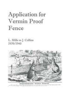
Document - Department of Lands and Survey, Wire Netting Branch, Melbourne, Victoria, Application for Vermin-Proof Fence Certificate - L.J. Mills vs John Collins, Grandview Grove, Ringwood, Victoria - 1939
... The land to the east across Grandview Avenue (sic) is all planted out in old established orchards and well cultivated. ...The land to the east across Grandview Avenue (sic) is all planted out in old established orchards and well cultivated. ...Photocopied file of corresponence and documentation relating to a claim by L.J. Mills, Nurseryman, that adjoining property owner, J. Collins, Farmer, assists with replacement of a vermin proof wire netting dividing fence destroyed by 1939 bushfire. File includes 1939 and 1940 detailed property inspection reports by Vermin and Noxious Weeds Branch, Lands Department, Lilydale, describing land use in the area and signs of vermin activity. Application approved 18th April, 1940. Appeal lodged by Mr Collins disallowed in May, 1940. File closed June, 1940 with Departmental suggesion that Mr Mills consider further legal action through a Solicitor as fence had still not been wire-netted. TRANSCRIPTS: Vermin & Noxious Weeds Inspection Reports "19/9/1939 (To) Superintendent (Department of Lands and Survey, Melbourne) Re L.J. Mills application for Vermin Proof Fence. I called on Mr Mills yesterday 18th instant in connection with this matter. Mr Mills has a flower farm and claims that rabbits and hares are damaging his flowers. He showed me a bed of carnations which he stated were being damaged by rabbits. There was evidence of some leaves being nipped off, but I am unable to say whether this is due to rabbits or grubs. Very little if any real damage is being done. The property is netted on the east and south boundary and on half the north and west boundary. The surrounding country is undlating and fairly steep in places. The land to the east across Grandview Avenue (sic) is all planted out in old established orchards and well cultivated. Cleared grass land adjoins the south boundary and bush land adjoins the north and west boundaries. I walked over a large area surrounding Mr Mills land and never saw any rabbits or hares or any indications of rabbits. This locality is not rabbit infested and very little wire netting is being used. I do not consider that a vermin proof fence is necessary between these allotments. - Jas H Allison (Inspector, Vermin and Noxious Weeds Branch, Lands Department, Lilydale)." Follow up report following renewal of application for Certificate by Mr Mills, citing rabbits causing considerable damage to his flowers. He laid poison and obtained 9 carcases and stated that there is evidence of rabbit infestation from the adjoing land. "19/3/1940 (To) Mr Hannah (Superintendant, Department of Lands and Survey, Melbourne) Re L.J. Mills, Grandview Grove Ringwood, Lot 4 Grandview Estate Pt CG20 Ph of Warrandyte. I interviewed Mr Mills at his home on 15th inst. He showed me carcases of rabbits which he stated had been poisoned on his land. In places young plants had been nipped off apparently by rabbits. I made an inspection of adjoining properties and found one live burrow close to Mr Mills northern boundary. There were scratches and other evidence of rabbits on land north and west of Mr Mills property. In view of the present evidence of rabbits I consider that a vermin proof fence is now necessary to protect the flowers grown by Mr Mills. His land is netted on whole of east and south boundary and half way on west and north boundary. The adjoining land on west and north boundaries is owned by Mrs Linda Collins and John Collins resp of Brysons Road East Ringwood. - Jas H Allison (Inspector, Vermin and Noxious Weeds Branch, Lands Department, Lilydale)." -
 Ringwood and District Historical Society
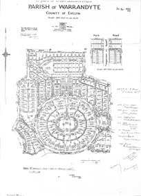
Document - Subdivision Map, Part of Crown Sections 18, 19, 24 & 25, Parish of Warrandyte, County of Evelyn, Vol 5228 Fol 472 - 1926. (Park Orchards, Victoria)
... Map includes Valley Road, Granard Avenue, Park Road, Arundel Avenue, Hylton Avenue, Aviemore Avenue, Bowmore Avenue, Hopetoun Road, Colin Avenue, Daintree Avenue, Brucedale Crescent, Feversham Avenue, Ennismore Crescent, Iona Grove, Elgin Crescent and Gosford Crescent, Park Orchards, Victoria....Ringwood and District Historical Society 125A Warrandyte Road Ringwood North melbourne Map includes Valley Road, Granard Avenue, Park Road, Arundel Avenue, Hylton Avenue, Aviemore Avenue, Bowmore Avenue, Hopetoun Road, Colin Avenue, Daintree Avenue, Brucedale Crescent, Feversham Avenue, Ennismore Crescent, Iona Grove, Elgin Crescent and Gosford Crescent, Park Orchards, Victoria. ...A3 and A4 sized photocopies showing map section of land title showing streets, easements and allotment numbers, some with handwritten names and pricing notations circa mid 1950s.Map includes Valley Road, Granard Avenue, Park Road, Arundel Avenue, Hylton Avenue, Aviemore Avenue, Bowmore Avenue, Hopetoun Road, Colin Avenue, Daintree Avenue, Brucedale Crescent, Feversham Avenue, Ennismore Crescent, Iona Grove, Elgin Crescent and Gosford Crescent, Park Orchards, Victoria. -
 Ringwood and District Historical Society
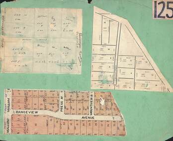
Card, Collage of Residential Subdivision Map Clippings - Ringwood, Victoria - (Undated)
... Orchards. Map with acres roods and perches measurements of allotments in Canterbury Road and Miller Street Heathmont. Clipping from a land sale brochure with street names not existing together in the area - Rangeview Avenue, Press Avenue and Mountview Avenue....Orchards. Map with acres roods and perches measurements of allotments in Canterbury Road and Miller Street Heathmont. Clipping from a land sale brochure with street names not existing together in the area - Rangeview Avenue, Press Avenue and Mountview Avenue. ...Three maps mounted on green cardboard - Hand-drawn map of residential allotments off Warrandyte Road in Milne Road and Berringa Road Park Orchards. Map with acres roods and perches measurements of allotments in Canterbury Road and Miller Street Heathmont. Clipping from a land sale brochure with street names not existing together in the area - Rangeview Avenue, Press Avenue and Mountview Avenue. -
 Ringwood and District Historical Society
Photograph, Looking from Royal Avenue, Heathmont towards Heathmont Road. This was the westerly end Herman Pump orchard
... Looking from Royal Avenue, Heathmont towards Heathmont Road. This was the westerly end Herman Pump orchard....Ringwood and District Historical Society 125A Warrandyte Road Ringwood North melbourne Looking from Royal Avenue, Heathmont towards Heathmont Road. This was the westerly end Herman Pump orchard. ... -
 Ringwood and District Historical Society
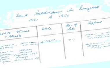
Document - Research Notes, Richard Carter, Land Subdivisions in Ringwood 1890-1950
... Station Street, William Street (now Kendall Street), Wantirna Road, Station Street Pg1 RINGWOOD TOWNSHIP ESTATE LP5577 (1913) Station Road (now Warrandyte Road), Pratt Street (part now Aird Street), Whitehorse Road Pg2 RINGWOOD ORCHARD ESTATE LP4315 (1914) Brysons Road, Hillcrest Road, Anzac Avenue, Sulva Road Pg3 RINGWOOD RAILWAY ESTATE LP7522 (1918) Whitehorse Road (now Mount Dandenong Road), Dublin Road, Freeman Street, Patterson Street, Bona Street Pg4 THE RINGWOOD ESTATE LP7578 (1919) Warrandyte Road, Hobart Street, Paxton Street, Arnold Street Pg5 GARDEN FARMS ESTATE (LP?) ...Station Street, William Street (now Kendall Street), Wantirna Road, Station Street Pg1 RINGWOOD TOWNSHIP ESTATE LP5577 (1913) Station Road (now Warrandyte Road), Pratt Street (part now Aird Street), Whitehorse Road Pg2 RINGWOOD ORCHARD ESTATE LP4315 (1914) Brysons Road, Hillcrest Road, Anzac Avenue, Sulva Road Pg3 RINGWOOD RAILWAY ESTATE LP7522 (1918) Whitehorse Road (now Mount Dandenong Road), Dublin Road, Freeman Street, Patterson Street, Bona Street Pg4 THE RINGWOOD ESTATE LP7578 (1919) Warrandyte Road, Hobart Street, Paxton Street, Arnold Street Pg5 GARDEN FARMS ESTATE (LP?) ...Handwritten table listing main local pre-1950s subdivisions in the Ringwood area, with estate names, streets, number of allotments for sale, and where known, vendor agent, LP (Lodged Plan) title registration number, and auction/sale date, some with sale price.Pg1 RINGWOOD STATION ESTATE LP3070 (Year?) Station Street, William Street (now Kendall Street), Wantirna Road, Station Street Pg1 RINGWOOD TOWNSHIP ESTATE LP5577 (1913) Station Road (now Warrandyte Road), Pratt Street (part now Aird Street), Whitehorse Road Pg2 RINGWOOD ORCHARD ESTATE LP4315 (1914) Brysons Road, Hillcrest Road, Anzac Avenue, Sulva Road Pg3 RINGWOOD RAILWAY ESTATE LP7522 (1918) Whitehorse Road (now Mount Dandenong Road), Dublin Road, Freeman Street, Patterson Street, Bona Street Pg4 THE RINGWOOD ESTATE LP7578 (1919) Warrandyte Road, Hobart Street, Paxton Street, Arnold Street Pg5 GARDEN FARMS ESTATE (LP?) (1919) Canterbury Road, Armstrong Road, Bungalook Road, Orchard Road, Bayswater Road (now Mountain Highway) Pg6 THE RINGWOOD ESTATE (SECOND SUB-DIVISION) LP7604 (1919) Warrandyte Road, Tamar Street, Derwent Street, Mersey Street Pg7 RINGWOOD STATION ESTATE LP7703 (1919) Bedford Road, Williams Grove (now Lena Grove) Pg8 RINGWOOD TOWNSHIP ESTATE LP8198 (1919) Wantirna Road, Ellison Street, Haig Street, Greenwood Avenue Pg9 EASTFIELD ESTATE (LP?) (1920) Eastfield Road, Longview Road, Pleasant Rise, The Mount Pg10 ELECTRIC RAILWAY ESTATE RINGWOOD LP9473 (1922) Campbell Street, Myrtle Avenue, George Street (now Tudor Court), Henry Street (now Myrtle Avenue), Williams Grove (now Lena Grove) Pg11 RINGWOOD PARK ESTATE LP7884 (1922 - two stages) Wonga Road (now Loughnan Road), William Street, Andrew Street, Harrison Street Pg12 HEATHMONT STATION ESTATE LP11009 (Date? - after 1922) Lisgoold Street, Viviani Crescent, Balrour Avenue, Station Street (now part Heathmont Road and part Wainui Street) Pg13 RINGWOOD RAILWAY ESTATE LP10507 (1923) Whitehorse Road, Sherbrooke Avenue, Burwood Avenue, Bonview Avenue, Heatherbrae Avenue, Grant Crescent Pg14 GARDEN HOMES ESTATE (LP?) (1923) Mullum Road, The Centreway, Wattle Crescent (now Wattle Avenue) Reserve Crescent (now Reserve Road) Pg15 DUBLIN ROAD ESTATE LP11993 (1923) Alexandra Road, Vonadawn Avenue, Green Street, Wood Street, Howard Avenue, Bedford Road, Dublin Road Pg16 CARLINGA ESTATE RINGWOOD LP9620 (1923) Bourke Street, Bond Street, Ringwood Street Pg17 PRATT'S JUNCTION ESTATE (LP?) (1923) Junction Street, Georges Road, Oliver Street, Whitehorse Road Pg18 EAST RINGWOOD ESTATE LP10492 (1923) Bona Street, Patterson Street, Miller Grove, Fairview Avenue, Eastfield Road, Whitehorse Road (now Mount Dandenong Road) Pg19 COLEMAN'S HEATHMONT ESTATE LP9974 (1923) Canterbury Road, Bedford Road, Alvena Crescent, Coleman Street, Leonard Street (now Royal Avenue) Pg20 RINGWOOD HEIGHTS ESTATE LP10506 (1924) Whitehorse Road, Bonview Avenue, Grant Crescent, Hillcrest Avenue, Heatherbrae Avenue, Margaret Street, Mary Street Pg21 EAST RINGWOOD STATION ESTATE LP10551 (1924) Knaith Road, Wenwood Street, Lois Street, Victoria Street, Station Street (now Railway Avenue) Pg22 GRAND VIEW ESTATE LP11019 (1924) Whitehorse Road, Rupert Street, Herbert Street, Leonard Street Pg23 RINGWOOD RAILWAY ESTATE & RINGWOOD HEIGHTS ESTATE - FINAL SECTIONS LP10506 & LP10507 (1924) Whitehorse Road, Sherbrooke Avenue, Burwood Avenue, Bonview Avenue, Heatherbrae Avenue, Margaret Street, Mary Street, Grant Crescent Pg24 RINGWOOD EAST ELECTRIC STATION ESTATE (LP?) (1924) Railway Parade (now Patterrson Street), Federal Road, Howship Avenue (part now French Street), Dublin Road, Rosedale Crescent Pg25 BEDFORD PARK (now Ringwood Secondary College) (LP?) (1924) Bedford Road, Adams Street, Anderson Street, Joyce Street, Graham Road Pg26 CROWN JEWEL ESTATE LP11645 (Private sales after 1924) Mount Dandenong Road, Mirabel Avenue, Valda Avenue, Evon Avenue, Velma Grove Pg27 GRAND CENTRAL ESTATE LP10917 (1925) Heathmont Road, Great Ryrie Street, Douglas Street, Garden Street, Bellevue Avenue Pg28 RINGWOOD (unnamed estate - 1926) Nelson Street, Seymour Street, Whitehorse Road Pg29 EAST RINGWOOD RAILWAY STATION ESTATE (YEAR? - 25 shops 60 villas) Railway Avenue, Dublin Road, Lawrence Grove, Stanley Avenue, Knaith Road Pg30 CHARM VIEW ESTATE (LP?) (year? - after 1926) Canterbury Road, Heathmont Road, Dickasons Road, Bennjett Avenue, Orchid Street Pg31 SUNBEAM ESTATE LP12150 (Circa 1925) Govt Road (now Old Lilydale Road), Sunbeam Avenue, Holland Road, Everard Street (now Everard Road) Pg32 FAIRVIEW ESTATE EAST RINGWOOD LP10853 (Circa 1924) Eastfield Road, Patterson Street, Margaret Street (now Short Street) Pg33 EAST RINGWOOD TOWNSHIP ESTATE LP3025 (Circa 1924 - 35 allotments) Mount Dandenong Road, Grey Street, Eastfield Road Pg34 EAST RINGWOOD TOWNSHIP ESTATE LP3025 (Circa 1924 - 49 allotments) and STATE SCHOOL ESTATE (26 allotments) and EAST RINGWOOD STATION ESTATE (14 shop sites) Mount Dandenong Road, Grety Street, Dunn Street, Eastfield Road, King Street, Holland Road, Dublin Road, Patterson Street, Bona Street Pg35 EAST RINGWOOD CENTRAL ESTATE LP17004 (1948) Knaith Road, Shasta Avenue, Talofa Avenue, Russet Road, Dublin Road Pg36 WARE ESTATE LP43360 (1958) Ware Crescent, Davey Drive, Grey Road (now Grey Street), Mount Dandenong Road Pg37 Lot 57 Kendall Street LP3070 (1939) £75.0.0 Pg37 Lot 14 LP7346 (year?) £225 Pg37 Lot 8 WHITE HORSE ESTATE LP14010 (year?) Maroondah Hwy, Seymour Street £98.9.0 Pg37 Lots 4-14 incl. LP10902 (year?) £300 Pg37 Lots 69&70 LP2216 (1939) Bedford Road, Pitt Street £500 Pg37 Lots 60&70 LP2216 (year?) £460 Pg37 MOUNTAIN VIEW ESTATE LP10902 (1936) Lots 1&2, 19-22 Wantirna Road, Daisy Street £50 Pg38 RAILWAY STATION ESTATE RINGWOOD EAST LP7522 (1925) Lots 16 to 19 £250 Pg38 RINGWOOD PARK ESTATE (LP?) (1924) Lot 112 Munro Street £230 Pg38 RINGWOOD TOWNSHIP ESTATE (LP?) (1925) Lot 57 Wantirna Road £850 Pg38 ELECTRIC RAILWAY ESTATE LP9473 (1925) Lot 98 & 99 £180 (30/- foot) Pg38 ELECTRIC RAILWAY ESTATE LP9473 (year?) Lot 100 £233.12.6 incl improvements (£2.12.6 foot) Pg38 Lot 22&23 Bedford Road Heathmont (LP & year?) £675 incl improvements Pg39 Lot 9 Mullum Mullum Road LP8221 (1923) £150 Pg39 Lot 27 Haig Street LP8198 (1925) £825 Pg39 Lot 56 Haig Street cnr Wantirna Road LP8198 (1923) £171 Pg39 Lots 3 & 4 Loughnan Road LP9626 (192?) £147 Pg39 Lots 98 & 99 Myrtle Avenue LP9473 (1925) £180 Pg39 Lots 80 & 81 Myrtle Avenue LP9473 (1929) £150 Pg39 Lot 30 Sherbrooke Avenue LP10507 (1926) £700 incl improvements Pg40 Lot 10 (year?) LP7703 £750 Pg40 Lot 36 (year?) LP7522 £25 Pg40 Lot 38 Pitt Street LP2216 (year?) £350 Pg40 Lot 7 Dublin Road cnr Green Street LP11993 (year?) £300 -
 Ringwood and District Historical Society
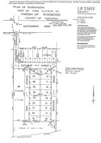
Document - Subdivision Plan, LP23855 Part of Crown Allotment 14B, Parish of Ringwood, County of Mornington, Vol 6687 Fol 394 - 1952
... Map includes Cuthbert Street, Orchard Grove, and Lowen Avenue (formerly part of Balfour Avenue), Heathmont. ...Ringwood and District Historical Society 125A Warrandyte Road Ringwood North melbourne Map includes Cuthbert Street, Orchard Grove, and Lowen Avenue (formerly part of Balfour Avenue), Heathmont. ...LANDATA Land Victoria plan printout circa 2008Map includes Cuthbert Street, Orchard Grove, and Lowen Avenue (formerly part of Balfour Avenue), Heathmont. Other markings include SP25736, LP98835 and LP40209. Accompanying pencil sketch on light cardboard backing includes sales notations on lots 4 to 8 on Sunset Drive and Cuthbert Street and comment - Roads to be formed & E.L&W provided by vendor. -
 Ringwood and District Historical Society
Document - Copy of Lands Department Field Notes - Parish of Ringwood, Victoria, Field Notes - OP34838 - surveyed in 1919 by D. Barker
... References include Braeside Avenue, Mount Dandenong Road, Rosedale Court, Railway Avenue, cyclone fence, Sec A, WB house, old tennis court netted, stable, old shed, tank stand, orchard, Township Boundary, netting fence, Railway fence, Ringwood to Lilydale Railway, I certify that these fieldnotes are a true copy of the actual results of observations & measurements taken by me on the ground (signed) D. ...References include Braeside Avenue, Mount Dandenong Road, Rosedale Court, Railway Avenue, cyclone fence, Sec A, WB house, old tennis court netted, stable, old shed, tank stand, orchard, Township Boundary, netting fence, Railway fence, Ringwood to Lilydale Railway, I certify that these fieldnotes are a true copy of the actual results of observations & measurements taken by me on the ground (signed) D. ...5615b Foolscap size photocopy of survey map with handwritten notations. References include Braeside Avenue, Mount Dandenong Road, Rosedale Court, Railway Avenue, cyclone fence, Sec A, WB house, old tennis court netted, stable, old shed, tank stand, orchard, Township Boundary, netting fence, Railway fence, Ringwood to Lilydale Railway, I certify that these fieldnotes are a true copy of the actual results of observations & measurements taken by me on the ground (signed) D. Barker (1919). -
 Ringwood and District Historical Society
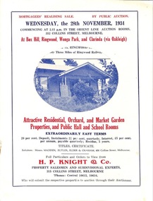
Flyer, Stillwell & Stephens Pty. Ltd, Brochure - Multiple Properties for Public Auction at Box Hill, Ringwood, Wonga Park and Clarinda - 28th November, 1934
... Wonga Park via Ringwood - "Holme Bush" off Warrandyte Road, Part of Lots 14 and 15, Ringwood Orchard Estate, approximatgely three miles (north) of Ringwood Railway Station - 64 Acres. 2. 17 Bishop Street, Box Hill - timber residence. 3. Greenwood Avenue...Wonga Park via Ringwood - "Holme Bush" off Warrandyte Road, Part of Lots 14 and 15, Ringwood Orchard Estate, approximatgely three miles (north) of Ringwood Railway Station - 64 Acres. 2. 17 Bishop Street, Box Hill - timber residence. 3. Greenwood Avenue ...Seven-page brochure advertising Mortgagees' Realising Sale by Public Auction on Wednesday, 28th November, 1934 for properties at Box Hill, Ringwood, Wonga Park, and Clarinda (via Oakleigh), including photographs, property descriptions, and terms of sale.Auction Commencing at 2.15 p.m. in the Orient Line Auction Rooms, 352 Collins Street, Melbourne. Solicitors: Messrs. Madden, Butler, Elder & Graham, 406 Collins Street, Melbourne. (Agents) H.P. Knight & Co. Property Salesmen and Subidivisional Experts, 315 Collins Street, Melbourne, 'Phones: Central 10615, 10616. Attractive Residential, Orchard, and Market Garden Properties, and Public Hall and School Rooms. 1. Wonga Park via Ringwood - "Holme Bush" off Warrandyte Road, Part of Lots 14 and 15, Ringwood Orchard Estate, approximatgely three miles (north) of Ringwood Railway Station - 64 Acres. 2. 17 Bishop Street, Box Hill - timber residence. 3. Greenwood Avenue, Ringwood - On East Side, 150 feet 3 inches South of Bedford Road - timber attic residence. 4. Ringwood - Wantirna Road, South-east corner of Canterbury Road - Orchard Property of approx. 11-1/2 Acres. 5. Box Hill - Whitehorse Road, South-east corner of Linsley Street - Timber building utilised as a Public Hall and Private School. 6. Clarinda vic Oakleigh, Talbot Crescent, off Centre Road - Home on 10 acres of land. -
 Ringwood and District Historical Society
Biography, Ringwood and District Historical Society, Interview notes - short biography on Miss Daisy Paddock, teacher at Ringwood State School, circa 1970s, c.1970s
... orchards. She goes on to say that the bush was alive with wildlife and a natural playground for the children. Miss Paddock was a member of the Soroptomist Club in RW (equivalent to Rotary), active in the church and local community. At our archives, we have a plaque that grac^ the entrance to the school, naming it the Miss Daisy Paddock library, in honour of a great woman in our city." Single page of notes/interview record of Miss Daisy Paddock, teacher at the Ringwood State School in Greenwood Avenue ...Single page of notes/interview record of Miss Daisy Paddock, teacher at the Ringwood State School in Greenwood Avenue (now Federation Estate) - Interview write-up by Ringwood History Group.Transcript: "Miss Janet Daisy Paddock She was an extremely well-liked and well-regarded teacher at the old RW State School in Greenwood Ave (Now Federation Estate). She taught between the years of 1927 until 1941, then again after the war from 1951 until final retirement in 1961. In fact she was so liked that her former pupils formed "The 2997 Club" , which met in her honour every year for a meal (and, of course, their guest of honour). 2997 was the RW SS number. In some of her letters about early life in RW, she recalls the RW Mail being produced and printed in a small wooden building in Adelaide St. [Adelaide St is officially no longer on the RW map but it went from the highway nearly to Mullum Creek, between Melbourne St and Warrandyte Road.^ In fact there is an unmarked 100 metres of road that is on the west side of Officeworks that ends in a roundabout at the bottom of Eastland carpark. I don't believe it is exactly in the same position as the old Adelaide Street but it pretty close. That would put the old Mail office in the vicinity of the Maroondah Council service centre in Eastland.] She also recalls that there were nearly a dam on every corner. In fact, I recall in my 1950s/60s childhood that there were still many dams around. As I previously mentioned, with the RW-Mitcham claybelt, there wasn't much top soil and the orange clay is very fine, so when the banks of the dam get wet, it wass very slippery. I often remember playing around in those dams, as most boys did in those days. A friend and I spied an old bath used to water some horses so after some trial and errors we made it waterproof and fashioned a couple of paddles out of wooden fence pailings. The first launch in the local dam was fine and we managed to manouver through the bullrushes into the middle. The only thing that I forgot about was that I had a d<^ that went everywhere with me and, rather than bark from the bank, he swam over to us and tried to get aboard. Bath tubs are not known for their seaworthness and he tipped us all in the drink. Of course the bath sank like a rock. We scrambled on the bank and he added insult to injury when, as all dogs do, gave the usual shake and sprayed us with water. My mind often comes back to one dam right next to the Croydon pub - that provided water to the Magg's orchard - dug in the usual fashion on about 3 metres deep scraped in the local clay, it was at this dam in the early sixties that a young boy drowned. After that we were pretty careful around dams. Going back to Daisy's memories, she recalls that the kids often started late on Monday mornings as Monday was Market Day at RW. They used to watch the stock being herded into the yards and people getting off the steam trains. Her family home was at Gruyere and her father used to drive to RW market and stop midway at the Burnt Bridge hotel and rest the horses. [I suspect that he may have watered other things besides the horses.] They eventually moved to RW in Thanet St. Miss Paddock still remembers the old RW school at the corner of RW St and Whitehorse Road, it was very small so they built the new school in Greenwood Ave. RW had a population of around 2,(K)0 when Daisy became an Assistant Class Five. She used to walk through the open paddocks, surrounded by bush and orchards. She goes on to say that the bush was alive with wildlife and a natural playground for the children. Miss Paddock was a member of the Soroptomist Club in RW (equivalent to Rotary), active in the church and local community. At our archives, we have a plaque that grac^ the entrance to the school, naming it the Miss Daisy Paddock library, in honour of a great woman in our city." -
 Ringwood and District Historical Society
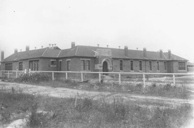
Photograph, Ringwood State School, Greenwood Avenue, Ringwood, on completion - 1922. Site was 3 1/2 acres of Count von Hariss' orchard. Land bought from A. Greenwood MLA"
... Ringwood State School, Greenwood Avenue, Ringwood, on completion - 1922. Site was 3 1/2 acres of Count von Hariss' orchard. ...Avenue on completion - 1922". Written on back of photograph, "1922 - Site was 3 1/2 acres of Count von Hariss(?) orchard...Avenue on completion - 1922". Written on back of photograph, "1922 - Site was 3 1/2 acres of Count von Hariss(?) orchard ...Typed below photograph, "Ringwood State School - Greenwood Avenue on completion - 1922". Written on back of photograph, "1922 - Site was 3 1/2 acres of Count von Hariss(?) orchard. Land bought from A. Greenwood MLA". Identical framed photograph located in bookshelves -NWD 01-02-03 -
 Ringwood and District Historical Society
Photograph, View of what was Heathmont township taken from about Royal Avenue looking at Mr. Herman Pump's orchard. Old bridge over Canterbury Road can be seen on left
... View of what was Heathmont township taken from about Royal Avenue looking at Mr. Herman Pump's orchard. Old bridge over Canterbury Road can be seen on left....Typed below photograph, "View of what was Heathmont township taken from about Royal Avenue looking at Mr. Herman Pump's orchard. Old bridge over Canterbury Road can be seen on left."...Ringwood and District Historical Society 125A Warrandyte Road Ringwood North melbourne Typed below photograph, "View of what was Heathmont township taken from about Royal Avenue looking at Mr. Herman Pump's orchard. Old bridge over Canterbury Road can be seen on left." ...Typed below photograph, "View of what was Heathmont township taken from about Royal Avenue looking at Mr. Herman Pump's orchard. Old bridge over Canterbury Road can be seen on left." -
 Ringwood and District Historical Society
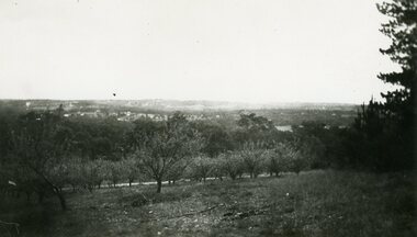
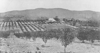
Photograph, View from Canterbury Road/Balfour Avenue area overlooking Martell's orchard, Heathmont, 1929
... View from Canterbury Road/Balfour Avenue area overlooking Martell's orchard, Heathmont, 1929....orchard. House in middle range, mountains in background. Photograph appears to be reproduced from subdivisional brochure. Note inserted in sleeve reads, "It has been pointed out that the mountains are to the east and the view is looking south. This therefore is not a 'straight' photograph. House still exists in Eden Avenue...View from Canterbury Road/Balfour Avenue area overlooking Martell's orchard, Heathmont, 1929. Photograph ...Black and white photograph of orchard. House in middle range, mountains in background. Photograph appears to be reproduced from subdivisional brochure. Note inserted in sleeve reads, "It has been pointed out that the mountains are to the east and the view is looking south. This therefore is not a 'straight' photograph. House still exists in Eden Avenue at October, 1996".(3 copies).Typed below photograph, "Panoramic view taken on the estate". "View overlooking Martell's orchard, Heathmont, 1929". Taken from corner Canterbury Rd. and Balfour Ave. looking south. Dandenong Creek just beyond house. Washusen Rd. on right". Written on back of one of the copies, "Heathmont Station Estate 1922". "Station Street, Lisgoold St. Canterbury Rd. Vivienne Cres. Balfour Ave." -
 Ringwood and District Historical Society
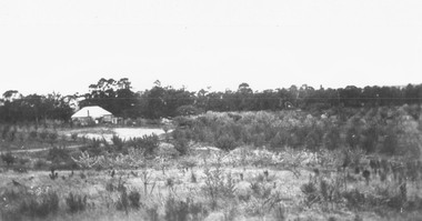
Photograph, Herman Pump's orchard and home Heathmont - 1923 - in vicinity of Royal Avenue. House on Canterbury Road, later site of Uniting Church
... Herman Pump's orchard and home Heathmont - 1923 - in vicinity of Royal Avenue. House on Canterbury Road, later site of Uniting Church....Typed on backing sheet below photograph, "Herman Pump's orchard and home Heathmont - 1923 - in vicinity of Royal Avenue. House on Canterbury Road, now site of Uniting Church"....Ringwood and District Historical Society 125A Warrandyte Road Ringwood North melbourne Typed on backing sheet below photograph, "Herman Pump's orchard and home Heathmont - 1923 - in vicinity of Royal Avenue. House on Canterbury Road, now site of Uniting Church". ...Black and white photograph of orchard. House in top left of photograph.Typed on backing sheet below photograph, "Herman Pump's orchard and home Heathmont - 1923 - in vicinity of Royal Avenue. House on Canterbury Road, now site of Uniting Church". -
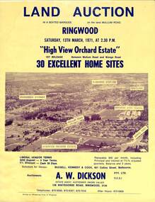 Ringwood and District Historical Society
Flyer, Land Auction Sale Brochure, High View Orchard Estate, Ringwood, Vic. - 1971
... Avenue, Hendra Grove, and Mullum Mullum Road. Agent - A.W. Dickson Pty. Ltd., 136 Whitehorse Road, Ringwood, 3134. Telephones: 870 6000, 870 6007, 870 7016, after hours 870 6868. A separate copy of the advertisement includes a local newspaper follow-up clipping reports thirty home sites grossing $102,350 at the auction. Double-sided advertisement for Ringwood High View Orchard ...Double-sided advertisement for Ringwood High View Orchard Estate land auction sale on Saturday, 13th March, 1971, including aerial photograph, map, and summary of local facilities and services.Subdivision includes Wonga Road, Oban Road, Sang Court, Ambrie Avenue, Hendra Grove, and Mullum Mullum Road. Agent - A.W. Dickson Pty. Ltd., 136 Whitehorse Road, Ringwood, 3134. Telephones: 870 6000, 870 6007, 870 7016, after hours 870 6868. A separate copy of the advertisement includes a local newspaper follow-up clipping reports thirty home sites grossing $102,350 at the auction. -
 Ringwood and District Historical Society
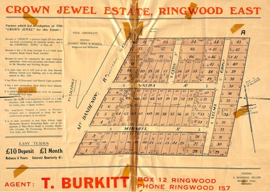
Memorabilia, History of "Jewel in the Crown" Estate, East Ringwood, Victoria, 1884-1947
... orcharding families. Collection of notes, titles and maps of "Jewel in the Crown" subdivision - Mount Dandenong Road (formerly Oxford Road), Velma Grove, Valda Avenue, Mirabel Avenue. ...Carter Real Estate Agents sold some of the subdivision in 1946-47. This information was tied in with the early orcharding families.Collection of notes, titles and maps of "Jewel in the Crown" subdivision - Mount Dandenong Road (formerly Oxford Road), Velma Grove, Valda Avenue, Mirabel Avenue. Genealogical charts of Meyland and Wigley families. 4 page history of the area compiled in 2004 by Richard Carter, Real Estate Agent. Registered Proprietors, Vendors, Property Title Holders and Transferees include: Herbert Edward WATSON, John Richard SHARP, Myrtle Evelyn BIRRELL, Marie Mathieson MUNRO, William Alex McCLELLAN, George Andrew GOODMAN, Joseph Tasman PEDRAZZI, Alexander ANDERSON, John Charles PATERSON, Eric William PHILLIPS, T.E.A. Co. Ltd., Florence Lavinia WYNARD, William John HARRIS, Lindsay and Hazel ALLNUTT, Douglas John RITCHIE, Eliza A.M. BOURBAND, Henrietta Irene COOK, Eric Edward COOK, Harold Thomas NICHOLLS, Stewart and Mary HIRD, Grace ROBINSON, Helen Rutherford GOOD, Henry Wyatt FARRELL, Irene Ann SMITH, Leslie Neil DOW, Helen Anne DOW, Frederick Ronald HOLDING, John Frederick McINTYRE, Horton Wilcox EDGE, Herbert James HARDINGHAM, Donald James ALLEN, Cyril Frederick WILLIAMS, Florence Sarah MAGGS, Maud Margaret PEARSON, Warwick Scott Holroyd MATTHEWS, Alice Eliza McCLEAVE, Leslie Archibald Charles HARRIS, Enid Beth HARRIS, Roy Victor DRAEGER, Elizabeth Ann STANDLEY, Charles Walter WATSON, Mabel Dorothy CARTER, Alan Garnett KELLY, Michael Vincent HARRIS, William Thomas Sylvester PROUD, Florence Blanche IVES, Douglas George PEARSON, Harry Clifford CLEGG, Dorothy Ellen Mary WHITE, Frederick Nathaniel EVANS, Madge EVANS, Leonard DUNSTAN, Violet Florence CONNELL, Valerie Jean Schimmelbusch, John Sydney COOK, William Donald THOMPSON, Ralph E RAUNSLEY, Murray McRae OSBORN, Francis William CLARKE, Alfred Daniel WILLIAMS, Harry Clifford CLEGG, Bernard Francis GARRY, Richard McKENZIE, Mignor Leonie WESTON, Idonea Moncrieffe DAVIS, Helen Marsden Rutherford GOOD, George SMART, Clement Henry DAVIS, Peter FINLAYSON, Elenor Leah HARVIE, Charles MEYLAND. -
 Ringwood and District Historical Society
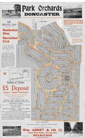
Map, Park Orchards Land Sale Advertisement, Doncaster, Victoria, Circa 1926
... Ringwood and District Historical Society 125A Warrandyte Road Ringwood North melbourne Subdivision includes Alva Avenue, Arundel Road, Aviemore Avenue, Berringa Road, Bowmore Avenue, Brucedale Crescent, Brympton Avenue, Camber Avenue, Cawdor Avenue, Colin Avenue, Corriedale Crescent, Craithie Avenue, Daintree Avenue, Dalry Avenue, Dirlton Crescent, Drayton Crescent, Elgin Crescent, Enfield Avenue, Ennismore Crescent, Euston Avenue, Feversham Avenue, Frogmore Crescent, Gosford Crescent, Granard Avenue, Hopetoun Road, Hylton Avenue (later Knees Road), Jura Avenue, Park Road. Large linen backed map of the Park Orchards subdivision for private sale of residential sites and recreation club, highlighting local facilities, services and layout of the estate. ...Large linen backed map of the Park Orchards subdivision for private sale of residential sites and recreation club, highlighting local facilities, services and layout of the estate. Surveyors - Tuxen & Miller, 34 Queen Street, Melbourne. Agents - Wm Addey & Co., Pty Ltd., National Mutual Buildings, 395 Collins Street, Melbourne, Phone F3906. Terms £5 deposit balance monthly installments of £1 with the residue at the end of five years. Subdivision includes Alva Avenue, Arundel Road, Aviemore Avenue, Berringa Road, Bowmore Avenue, Brucedale Crescent, Brympton Avenue, Camber Avenue, Cawdor Avenue, Colin Avenue, Corriedale Crescent, Craithie Avenue, Daintree Avenue, Dalry Avenue, Dirlton Crescent, Drayton Crescent, Elgin Crescent, Enfield Avenue, Ennismore Crescent, Euston Avenue, Feversham Avenue, Frogmore Crescent, Gosford Crescent, Granard Avenue, Hopetoun Road, Hylton Avenue (later Knees Road), Jura Avenue, Park Road. -
Whitehorse Historical Society Inc.
Document, Zander Avenue, 7/01/1986
... Zander Avenue named after the Zanders who had an apple orchard there. Wright Family owned a milk bar in Springfield Road and they built Mountain view shops in Springfield Road. ...Nicoll Reserve was a pear orchard owned by the Aytons. Zander Avenue Document Document ...Memories by Merle Duncan recorded 7/1/1986. Zander Avenue named after the Zanders who had an apple orchard there. Wright Family owned a milk bar in Springfield Road and they built Mountain view shops in Springfield Road. The old manse, now the Nunawading North Community House was their home. Nicoll Reserve was a pear orchard owned by the Aytons.roads and streets, zander avenue, nunawading, nunawading, duncan, merle, wright family, mountain view shops, springfield road, nunawading, nicoll reserve, ayton family, zander family -
Whitehorse Historical Society Inc.
Article, A Fruitful History, 2013
... Whitehorse Historical Society Inc. 2-10 Deep Creek Road Mitcham melbourne Built in an orchard county (2 pages including photos). Norway Avenue Blackburn No. 9 Peowrie Kevin A property review of a 1920s house. ...A property review of a 1920s house.A property review of a 1920s house built in an orchard county (2 pages including photos).A property review of a 1920s house.norway avenue blackburn no. 9, peowrie, kevin -
Whitehorse Historical Society Inc.
Legal record - Land Title, Spall Orchard, 1916-1982
... Wattle Valley Road Mitcham Highland Avenue Mitcham Trenham Court Mitcham Spall James George Spall Sybil Margaret Vaughan Francis Arnold Schwerkolt Louis Mill Shirley Land Titles Certificates of Title relating to the Spall Orchard, Wattle Valley Road Mitcham and surrounding parts of Crown Portion 128, Parish of Nunawading. ...Certificates of Title relating to the Spall Orchard, Wattle Valley Road Mitcham and surrounding parts of Crown Portion 128, Parish of Nunawading.Certificates of Title relating to the Spall Orchard, Wattle Valley Road Mitcham and surrounding parts of Crown Portion 128, Parish of Nunawading. Principal landowners: Louis Schwerkolt (Vol.3955 Fol.825), Francis Arnold Vaughan and James George & Sybil Margaret Spall (Vol.8249 Fol. 849). With historical summary, agent's sale notice 1984 and letter from Shirley Mill.Certificates of Title relating to the Spall Orchard, Wattle Valley Road Mitcham and surrounding parts of Crown Portion 128, Parish of Nunawading.wattle valley road, mitcham, highland avenue mitcham, trenham court mitcham, spall, james george, spall, sybil margaret, vaughan, francis arnold, schwerkolt, louis, mill, shirley, land titles -
Whitehorse Historical Society Inc.
Newspaper - Article, Old spacious home key to past Mitcham, 24/01/1968
... Avenue. The estate was known locally as 'Mother Foster's Estate'. Mr James Thatcher brought the brochure to the Gazette - his grandfather, Joseph Lloyd bought land at that sale. David Lloyd (Thatcher's uncle) lived there. James Thatcher had an orchard...Avenue. The estate was known locally as 'Mother Foster's Estate'. Mr James Thatcher brought the brochure to the Gazette - his grandfather, Joseph Lloyd bought land at that sale. David Lloyd (Thatcher's uncle) lived there. James Thatcher had an orchard ...Article in Nunawading Gazette about 'Windouran', a spacious home unchanged since its picture was used to boost Mitcham's first subdivision sale. It has been divided into 2 flats but still looks stately. In 1915 70 big home sites were sold in an area bounded by Mitcham Road, Halls Parade, Orient Avenue and Vernal Avenue. The estate was known locally as 'Mother Foster's Estate'. Mr James Thatcher brought the brochure to the Gazette - his grandfather, Joseph Lloyd bought land at that sale. David Lloyd (Thatcher's uncle) lived there. James Thatcher had an orchard at that time on a hill above Centre Road, Vermont.houses, windouran, windouran drive, mitcham, mitcham, thatcher, james, mitcham road, mitcham, halls parade, mitcham, orient avenue, mitcham, vernal avenue, mitcham, mother foster's estate, lloyd, joseph, lloyd, david, simon, kingsley -
Whitehorse Historical Society Inc.
Document, McCracken Street, Blackburn South, 1995
... Avenue...Blackburn South...Orchard...Whitehorse Historical Society Inc. 2-10 Deep Creek Road Mitcham melbourne Street Names McCracken Avenue Blackburn South Orchard Grove Blackburn South Lawrence Street Blackburn South Gray Beryl History of McCracken Street, Blackburn South by Beryl Gray, Nunawading Historical Society [actually McCracken Avenue] History of McCracken Street, Blackburn South by Beryl Gray, Nunawading Historical Society [actually McCracken Avenue] McCracken Street, Blackburn South Document Document ...History of McCracken Street, Blackburn South by Beryl Gray, Nunawading Historical Society [actually McCracken Avenue]History of McCracken Street, Blackburn South by Beryl Gray, Nunawading Historical Society [actually McCracken Avenue]History of McCracken Street, Blackburn South by Beryl Gray, Nunawading Historical Society [actually McCracken Avenue]street names, mccracken avenue, blackburn south, orchard grove, blackburn south, lawrence street, blackburn south, gray, beryl -
Whitehorse Historical Society Inc.
Legal record - Land Title, Certificate of Title, 1932
... Orchard Grove...Blackburn South...Simla Street...Mitcham...Orient Avenue...Whitehorse Historical Society Inc. 2-10 Deep Creek Road Mitcham melbourne Shire of Blackburn and Mitcham Orchard Grove Blackburn South Simla Street Mitcham Orient Avenue Mitcham Land Titles Charlesworth Albert Roy Canterbury Road Blackburn South Halls Parade Mitcham Furness Albert George Kemp Frank Lemke Gustav Robert Huffey Emily May A letter to Mr A. ...A letter to Mr A. Roy Charlesworth, valuer, Shire of Blackburn and Mitcham, accompanying four copies of certificates of title.A letter to Mr A. Roy Charlesworth, valuer, Shire of Blackburn and Mitcham, accompanying four copies of certificates of title.A letter to Mr A. Roy Charlesworth, valuer, Shire of Blackburn and Mitcham, accompanying four copies of certificates of title.shire of blackburn and mitcham, orchard grove, blackburn south, simla street, mitcham, orient avenue, mitcham, land titles, charlesworth, albert roy, canterbury road, blackburn south, halls parade, mitcham, furness, albert george, kemp, frank, lemke, gustav robert, huffey, emily may