Showing 164 items matching "original homestead"
-
 Buninyong & District Historical Society
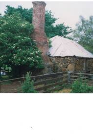
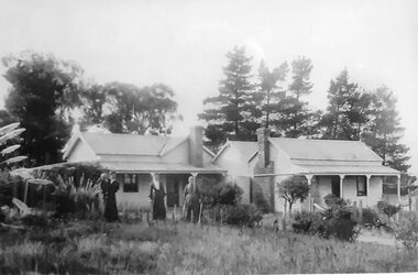
Photograph - Colour photograph early homestead, The original homestead building of the Scott family of Mt Boninyong
... The original homestead building of the Scott family of Mt Boninyong......Original Homestead...A colour photograph of the original stone homestead of Mt Boninyong...One of a series of photographs taken of early buildings in the district for Buninyong and District Historical Society This photograph shows the original homestead built on Mt Boninyong by the Scott family Mount Boninyong Scott Family Scotsburn Original Homestead A colour photograph of the original stone homestead of Mt Boninyong The original homestead building of the Scott family of Mt Boninyong Photograph Colour photograph early homestead ...One of a series of photographs taken of early buildings in the district for Buninyong and District Historical SocietyThis photograph shows the original homestead built on Mt Boninyong by the Scott familyA colour photograph of the original stone homestead of Mt Boninyongmount boninyong, scott family, scotsburn, original homestead -
 Whitehorse Historical Society Inc.
Article, Blackburn bellbird heritage
... Of an original Blackburn homestead 'Koolangara' for sale....Advertisement in Nunawading Gazette of an original Blackburn homestead 'Koolangara' for sale....Whitehorse Historical Society Inc. 2-10 Deep Creek Road Mitcham melbourne Of an original Blackburn homestead 'Koolangara' for sale. Koolangara Blackburn Real Estate Advertisement in Nunawading Gazette. ...Advertisement in Nunawading Gazette.Advertisement in Nunawading Gazette of an original Blackburn homestead 'Koolangara' for sale.Advertisement in Nunawading Gazette. koolangara, blackburn, real estate -
 Victorian Interpretive Projects Inc.
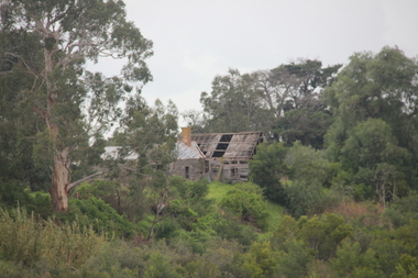
Photograph - colour, Lisa Gervasoni, Ruins of Angus McMillan's original Bushy Park Homestead near Maffra, 2014, 07/06/2014
... Ruins of Angus McMillan's original Bushy Park Homestead near Maffra, 2014...(wikipedia) Bushy Park angus mcmillan avon river Ruins of Angus McMillan's original Bushy Park Homestead near Maffra, 2014 Photograph - colour Lisa Gervasoni ...Angus McMillan named the Avon River after the river of the same name in his native Scotland. In 1840 he established a pastoral run at Bushy Park, north-west of the township. William Odell Raymond established a run in the area in 1842, and built his house, Strathfieldsaye, during 1848–54. European settlement did not take place without resistance, and in return, massacres were inflicted by Angus McMillan and others on Gunai people, especially between the years of 1840 and 1850. (wikipedia)bushy park, angus mcmillan, avon river -
Whitehorse Historical Society Inc.
Newspaper - Article, Mock Street, Forest Hill, 11/12/1996
... Auction of original homestead, 4 rooms....Auction of original homestead, 4 rooms. Mock Street, Forest Hill Newspaper Article ...Mock Street, Forest Hill, No 11. Advertisement in Nunawading Gazette. Auction of original homestead, 4 rooms.mock street, forest hill, auctions -
 Whitehorse Historical Society Inc.
Photograph, Orchard - Schwerkolt Cottage, 21/04/2001 12:00:00 AM
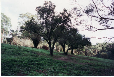
... Coloured photo of Orchard Trees planted by Schwerkolt Family on original Homestead site, abutting Schwerkolt Cottage Reserve....Whitehorse Historical Society Inc. 2-10 Deep Creek Road Mitcham melbourne schwerkolt cottage orchards Coloured photo of Orchard Trees planted by Schwerkolt Family on original Homestead site, abutting Schwerkolt Cottage Reserve. ...Coloured photo of Orchard Trees planted by Schwerkolt Family on original Homestead site, abutting Schwerkolt Cottage Reserve.schwerkolt cottage, orchards -
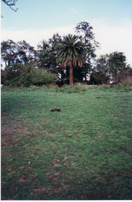
 Whitehorse Historical Society Inc.
Photograph, Palm Tree - Schwerkolt Cottage, 21/04/2001 12:00:00 AM
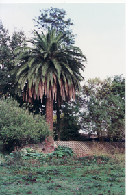
... Coloured photo of Palm Tree on original Schwerkolt Homestead land, abutting Schwerkolt Cottage Reserve....Whitehorse Historical Society Inc. 2-10 Deep Creek Road Mitcham melbourne schwerkolt cottage palm trees Coloured photo of Palm Tree on original Schwerkolt Homestead land, abutting Schwerkolt Cottage Reserve. ...Coloured photo of Palm Tree on original Schwerkolt Homestead land, abutting Schwerkolt Cottage Reserve.schwerkolt cottage, palm trees -
 Stawell Historical Society Inc
Photograph, Mokepilly Station Cemetery on Mokepilly property Mount William Creek -- Coloured
... Two photographs taken at Mokepilly Station one of remnants of the original homestead. The second of Mokepilly Cemetery at Mount William Creek. ...Stawell Historical Society Inc 46 Longfield St Stawell grampians Two photographs taken at Mokepilly Station one of remnants of the original homestead. The second of Mokepilly Cemetery at Mount William Creek. stawell Two colour photographs of bush setting including slab fencing plus a fenced area with a gate way. ...Two photographs taken at Mokepilly Station one of remnants of the original homestead. The second of Mokepilly Cemetery at Mount William Creek. Two colour photographs of bush setting including slab fencing plus a fenced area with a gate way.stawell -
 Lake Bolac & District Historical Society
black and white photograph, Lake Boloke Homestead
... Lake Bolac's original homestead built c 1850's....Lake Bolac's original homestead built c 1850's. lake boloke, bolac, homestead black and white photograph Lake Boloke Homestead black and white photograph ...Photograph of Lake Boloke Homestead situated on the shores of Lake Bolac. Lake Bolac's original homestead built c 1850's.black and white photographlake boloke, bolac, homestead -
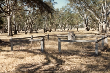
 Eltham District Historical Society Inc
Photograph, Peter Pidgeon, Killeavey, Laughing Waters Road, Eltham 5 Nov 2016, 5 Nov 2016
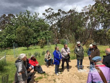
... The Wurundjeri ceremonial circle at Killeavey which has been constructed on the site of the original homestead which was destroyed in the 1839 bushfires. ...Eltham District Historical Society Inc 728 Main Rd Eltham melbourne The Wurundjeri ceremonial circle at Killeavey which has been constructed on the site of the original homestead which was destroyed in the 1839 bushfires. ...The Wurundjeri ceremonial circle at Killeavey which has been constructed on the site of the original homestead which was destroyed in the 1839 bushfires. Heriitage Excursion - Kileavey Walk and TalkBorn Digitalactivities, eltham district historical society, heritage excursion, kileavey, parks victoria, laughing waters road, eltham, wurundjeri -
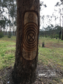 Eltham District Historical Society Inc
Photograph, Peter Pidgeon, Killeavey, Laughing Waters Road, Eltham 5 Nov 2016, 5 Nov 2016
... This tree carving represents the ceremonial circle at the meeting place formed on the site of the original homestead. The replicating circles reflecting the life stories. ...Eltham District Historical Society Inc 728 Main Rd Eltham melbourne This tree carving represents the ceremonial circle at the meeting place formed on the site of the original homestead. The replicating circles reflecting the life stories. ...This tree carving represents the ceremonial circle at the meeting place formed on the site of the original homestead. The replicating circles reflecting the life stories. Heriitage Excursion - Kileavey Walk and TalkBorn Digitalactivities, eltham district historical society, heritage excursion, kileavey, parks victoria, laughing waters road, eltham, wurundjeri -
 Linton and District Historical Society Inc
Photograph, 'Glenfine' Shearing Shed, 1890
... Glenfine was a pastoral station, and the original homestead still stands....Glenfine was a pastoral station, and the original homestead still stands. 'Glenfine' Shearing Shed, 1890 Photograph Photograph ...In July 1840, Glenfine, consisting of 31,440 acres, was acquired by Thomas Downie. In March 1842 the 'Right of Run' was taken up by Thomas Chirnside who with an imported stallion 'Delapre' ran a horse stud. He apparently lived here for ten years and employed a gardener with a wife and five children from Hobart, Tasmania. Only some blocks of stone and a few trees remain of their homestead. In 1853 the property was transferred to Dr. John Chirnside, an elder brother of Thomas Chirnside. In 1857, William Rowe of Naringal purchased Glenfiine where he and his family lived until 1904 when it was bought by Richard Howell's estate. It was then 39,000 acres. The present house was built by the Rowes in 1872 of bluestone quarried on the property with a cement render overall. The architect was H.R. Casselli. Gold was found on the property and by 1898 the township of Hollybush was first reported, situated at either side of the front entrance, on the Cressy Road. The land for the township was given by William Rowe. In 1911 R.C. Howell, son of Richard Howell, became the owner, followed by his son in 1960. By 1990 Hollybush had a population of 426 persons. All of the early history of Glenfine, documents etc., were destroyed when Naringal homestead was burnt down in 1944. Glenfine was classified by the National Trust in 1974 and is on the Heritage Commission Register. Mounted black and white image of a large group of men and boys in front of a weatherboard shearing shed. The men are each holding a pair of hand shears. One young man is kneeling on top of a wool bale. A small blue biro 'x' identifies W. Todd. Glenfine was a pastoral station, and the original homestead still stands.shearing sheds, shearers, rural activity, william todd, glenfine pastoral station, thomas chirnside, thomas downie, richard howell, william thomas rowe -
 Hume City Civic Collection
Photograph, Emu Bottom Homestead
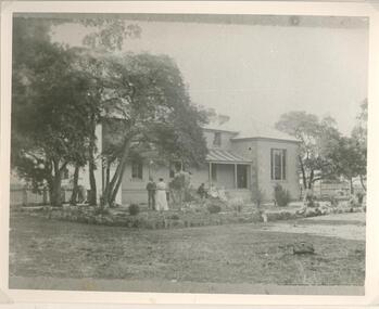
... George Evans, one of the district's earliest European settlers built the original homestead from Silurian sandstone removed from the surrounding hillsides in the 1830s....George Evans, one of the district's earliest European settlers built the original homestead from Silurian sandstone removed from the surrounding hillsides in the 1830s. ...The photograph was taken from the rear of the Emu Bottom Homestead and its outbuildings in front of the home paddock. George Evans, one of the district's earliest European settlers built the original homestead from Silurian sandstone removed from the surrounding hillsides in the 1830s.A black and white landscape photograph with a cream border of a farm house and outbuildingsemu bottom homestead, homesteads, george evans, jackson creek, sunbury -
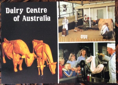 Phillip Island and District Historical Society Inc.
Postcard, Scancolor Australia et al, Dairy Centre and Rhylstone Park, Phillip Island, C. 1980s
... This unique collection is enhanced by the original homestead with beautiful lead light, ornate metal ceilings and marble fireplaces....This unique collection is enhanced by the original homestead with beautiful lead light, ornate metal ceilings and marble fireplaces. ...Two coloured postcards. One of displays at the Dairy Centre, Newhaven. The second of Rhylston Park homestead, Cowes and it’s display of antiques and clocks.Dairy Museum, Phillip Island Road, Newhaven. Victoria 3925. Phone (059)567583 All Hours Rhylston Park Homestead Thompson Ave Cowes 3922 Phone (059)59522856. Rhylston Park(1886) features a display of over 380 antique clocks and watches. This unique collection is enhanced by the original homestead with beautiful lead light, ornate metal ceilings and marble fireplaces.the dairy centre, newhaven, homes, postcards -
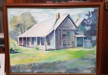 Numurkah & District Historical Society
Painting - Coonanga Homestead
... Original painting of Coonanga Homestead by Helen Sigley, 1986...Numurkah & District Historical Society Old Bank Building cnr Melville and Knox Street (118-120 Melville St) Numurkah the-murray The painting was raffled by the historical society in 1986 and won by Donna Russell Coonanga Homestead, painting, Helen Sigley Original painting of Coonanga Homestead by Helen Sigley, 1986 Painting - Coonanga Homestead ...The painting was raffled by the historical society in 1986 and won by Donna RussellOriginal painting of Coonanga Homestead by Helen Sigley, 1986coonanga homestead, painting, helen sigley -
 Whitehorse Historical Society Inc.
Photograph, Palm Tree - Schwerkolt Homestead, 21/04/2001 12:00:00 AM
... Coloured photo of Palm Tree on original Schwerkolt Family Homestead, abutting Schwerkolt Cottage Reserve....Whitehorse Historical Society Inc. 2-10 Deep Creek Road Mitcham melbourne schwerkolt cottage palm trees Coloured photo of Palm Tree on original Schwerkolt Family Homestead, abutting Schwerkolt Cottage Reserve. ...Coloured photo of Palm Tree on original Schwerkolt Family Homestead, abutting Schwerkolt Cottage Reserve.schwerkolt cottage, palm trees -
 Melton City Libraries
Photograph, Wendy, Bon and Peter Barrie, c.1948
... The construction to the west passed over the paddocks and the internal track along the fences connecting the Barrie brothers to the original Homestead at the Toolern Creek. ...The construction to the west passed over the paddocks and the internal track along the fences connecting the Barrie brothers to the original Homestead at the Toolern Creek. Local Identities Wendy, Bon and Peter Barrie entering Ferris Road from house Wendy, Bon and Peter Barrie Photograph Barrie Collection ...Sections of the property from the Ferris Rd to the Toolern Creek were compulsorily acquired for the construction of the Melton By Pass road to become the Western Freeway. The freeway plan divided the original 1911“Darlingsford” farm. The section of the Ferris Rd 70-acre paddock belonging to Bon became the Freeway and roundabout. The construction to the west passed over the paddocks and the internal track along the fences connecting the Barrie brothers to the original Homestead at the Toolern Creek. Wendy, Bon and Peter Barrie entering Ferris Road from houselocal identities -
 Eltham District Historical Society Inc
Negative - Photograph, Allwood, Hurstbridge, 1903
... Original homestead built 1837 at Allwood by G. Haley, later (1868) sold to F.G. ...Eltham District Historical Society Inc 728 Main Rd Eltham melbourne Original homestead built 1837 at Allwood by G. Haley, later (1868) sold to F.G. ...Original homestead built 1837 at Allwood by G. Haley, later (1868) sold to F.G. Hurst who lived here from 1857 with his parents - also the scene of the shooting (and death) of Henry Facey Hurst (elder brother of F.G.) by the bushranger Burke on 4 October 1866. View of rear entrance looking east. Fred. Geo. Hurst and grandchildren, Hurst Gray and Sylvia Gray (Birch) on verandah. The chair was carved from a solid log. Reproduced on p78 of 'Pioneers & Painters'This photo forms part of a collection of photographs gathered by the Shire of Eltham for their centenary project book,"Pioneers and Painters: 100 years of the Shire of Eltham" by Alan Marshall (1971). The collection of over 500 images is held in partnership between Eltham District Historical Society and Yarra Plenty Regional Library (Eltham Library) and is now formally known as the 'The Shire of Eltham Pioneers Photograph Collection.' It is significant in being the first community sourced collection representing the places and people of the Shire's first one hundred years.Digital image 4 x 5 inch B&W Negsepp, shire of eltham pioneers photograph collection, hurstbridge, allwood house, allwood, g haley, houses, hurst, pioneers and painters, frederick george hurst, hurst gray, sylvia birch (nee gray), sylvia gray -
 Stawell Historical Society Inc
Photograph, “Swinton” Homestead in Glenorchy with alight pole and flagpole on the front lawn, 1913 approx
... After severe floods in 1909 the original homestead was destroyed. This home picture was built in 1911 on a site on higher grounds....After severe floods in 1909 the original homestead was destroyed. This home picture was built in 1911 on a site on higher grounds. glenorchy B/W. ...Black and white photo of “Swinton” Homestead Glenorchy with light pole and flagpole on front lawn. Swinton was a family name of John Carfrae whose father was Thomas Swinton Carfrae of Edinburgh. When John Carfrae came to Ledcourt in 1848 he divided it into three runs, Ledcourt - Swinton & Newington. Alexander Grey came to Swinton in 1881. The Grey Family still live at Swinton. After severe floods in 1909 the original homestead was destroyed. This home picture was built in 1911 on a site on higher grounds.B/W. Photograph: of a substantial house with five chimneys and verandah and Flagpole, in the mid distance is a light pole with a gas light, in the foreground is a tree. This photograph is a copy of a negative owned by the society. Paid with a grant 1991. this photograph is of the home at SWINTON Glenorchy. glenorchy -
 Lakes Entrance Historical Society
Photograph - Nyerimilang Jetty track, c1920's
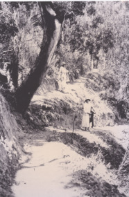
... Black and white photo of two women and children on the rough original track from Nyerimilang Homestead to the jetty...Perhaps the Stuart family Parks Stuart Family Black and white photo of two women and children on the rough original track from Nyerimilang Homestead to the jetty Photograph Nyerimilang Jetty track ...Perhaps the Stuart family Black and white photo of two women and children on the rough original track from Nyerimilang Homestead to the jettyparks, stuart family -
 Stawell Historical Society Inc
Photograph, Swinton Family Home Station in Glenorchy 1866
... The present home was built in 1911 after severe floods in 1909 destroyed the original homestead. ...The present home was built in 1911 after severe floods in 1909 destroyed the original homestead. Stawell Aborigional Wooden cottage with outbuildings in front of trees. ...Swinton Home Station. Part of a collection of Photographs by Mr. O.G. Armstrong as commissioned by the Shire of Stawell for the Inter-colonial and Paris Exhibition in Melbourne in 1866. Swinton was a family name of John Carfrae, whose father was Thomas Swinton Carfrae of Edinburgh. When John Carfrae came to Ledcourt in 1848 he divided it into three runs, Ledcourt, Swinton and Newington. John Holt occupied Ledcourt and Swindon before 1865, at which time Marcus Clarke was a jackaroo. Alexander Gray came to Swinton in 1881. The Grey family still live at Swinton. The present home was built in 1911 after severe floods in 1909 destroyed the original homestead. Wooden cottage with outbuildings in front of trees. A number of men women and First Nations people standing and sitting in front.stawell aborigional -
 Eltham District Historical Society Inc
Negative - Photograph, ‘Worlingworth’, Yarra River, Eltham
... ‘Worlingworth’, Yarra River, Eltham Original homestead on the property ‘Worlingworth’, a large residence and surrounding farm site standing on a knoll above the River Yarra in Banoon Road, Eltham. ...Eltham District Historical Society Inc 728 Main Rd Eltham melbourne ‘Worlingworth’, Yarra River, Eltham Original homestead on the property ‘Worlingworth’, a large residence and surrounding farm site standing on a knoll above the River Yarra in Banoon Road, Eltham. ...‘Worlingworth’, Yarra River, Eltham Original homestead on the property ‘Worlingworth’, a large residence and surrounding farm site standing on a knoll above the River Yarra in Banoon Road, Eltham. The present house was built about 1922 and was originally owned by Mr A.R. Read, a stock and station agent and member of the Stock Exchange (who left the district in early 1926 to take up permanent residence at his Warburton property). It became the home of notable anthropologist Prof. Dr. Donald Thomson (1901-1971) and Mrs. Gladys Thomson who were married in 1925 and had twin sons in 1934 and is considered historically and aesthetically significant to the Shire of Nillumbik.This photo forms part of a collection of photographs gathered by the Shire of Eltham for their centenary project book, "Pioneers and Painters: 100 years of the Shire of Eltham" by Alan Marshall (1971). The collection of over 500 images is held in partnership between Eltham District Historical Society and Yarra Plenty Regional Library (Eltham Library) and is now formally known as 'The Shire of Eltham Pioneers Photograph Collection.' It is significant in being the first community sourced collection representing the places and people of the Shire's first one hundred years.Digital image 4 x 5 inch B&W Negshire of eltham pioneers photograph collection, a.r. read, banoon road, donald thomson, eltham, gladys thomson, worlingworth, yarra river -
 Phillip Island and District Historical Society Inc.
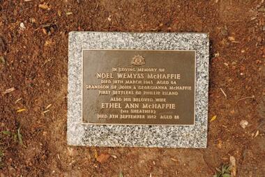
Photograph Album, Kodak, Phillip Island Cemetery, c 1990
... Noel's ashes are interred at the Phillip Island Cemetery and Vernon's were scattered at Ventnor Philip Island at the site of the original homestead. 466-17 & 466-18: As per the Plaque: "Mulberry Tree: Muberry cutting from original tree planted by John D McHaffie First Settlers Phillip Island 1842. ...Noel's ashes are interred at the Phillip Island Cemetery and Vernon's were scattered at Ventnor Philip Island at the site of the original homestead. 466-17 & 466-18: As per the Plaque: "Mulberry Tree: Muberry cutting from original tree planted by John D McHaffie First Settlers Phillip Island 1842. ...The Album was compiled by Nancy McHaffie late 1990's, with the assistance of Edith Jeffery's, with her book "Garden of Memories" and extensive knowledge of Phillip Island. The Cemetery lies back from the road and is surrounded by Manna Gums, rare Peppermint Gums, Blackwoods and other native trees. In all 25 acres of land were set aside as Crown Land in the land settlement of 1868. There are 6.2 acres of wetlands near the cemetery entrance.4 photographs relating to the McHaffie family. 466-15 & 466-16: Noel Wemyss & Vernon Suter Wemyss McHaffie were grandchildren of the first permanent European Settlers of Phillip Island (John David & Georgianna McHarrie who leased the whole Island as a sheep and cattle run for 45 years until Closer Settlement in 1868 reduced their holding to 640 acres and who are buried at the St. Kilda Cemetery, Melbourne). Noel's ashes are interred at the Phillip Island Cemetery and Vernon's were scattered at Ventnor Philip Island at the site of the original homestead. 466-17 & 466-18: As per the Plaque: "Mulberry Tree: Muberry cutting from original tree planted by John D McHaffie First Settlers Phillip Island 1842. Plaque by courtesy Cherry McFee 1987.phillip island cemetery, nancy mchaffie, edith jeffrey -
 Stawell Historical Society Inc
Photograph, "Mont Glen" Homestead - Watta Wella
... Original "Mont Glen" homestead - Watta Wella. Bulit by Joh Blades Hall Senior - Located 300 metres behind "Lynleigh" (Home of grandson Collin Hall) - Later was the residence of his son Jahn Blades Hall Jnr....Stawell Historical Society Inc 46 Longfield St Stawell grampians Original "Mont Glen" homestead - Watta Wella. Bulit by Joh Blades Hall Senior - Located 300 metres behind "Lynleigh" (Home of grandson Collin Hall) - Later was the residence of his son Jahn Blades Hall Jnr. ...Original "Mont Glen" homestead - Watta Wella. Bulit by Joh Blades Hall Senior - Located 300 metres behind "Lynleigh" (Home of grandson Collin Hall) - Later was the residence of his son Jahn Blades Hall Jnr.B/W Photo. Weathe board buildings , 2 chimneys, Pine trees behind. 3 Women in long dresses, 1 holding a child -
 Phillip Island and District Historical Society Inc.
Photograph, Picnic at Nobbies, 1917
... homestead with 1920s Arts and Crafts styling was built by A.K.T. (Albert Keaston Trenavin) Sambell, the the island’s first shire president. It sits just above the original...homestead with 1920s Arts and Crafts styling was built by A.K.T. (Albert Keaston Trenavin) Sambell, the the island’s first shire president. It sits just above the original ...The double-storey homestead with 1920s Arts and Crafts styling was built by A.K.T. (Albert Keaston Trenavin) Sambell, the the island’s first shire president. It sits just above the original site of the homestead of the pioneering McHaffie brothers, the Island’s first settlers.HistoricalLarge black and white photograph of a flat topped cart with no sides, pulled by 2 draught horses. Water tank on stand in rural background & people sitting on the cart. 3 women wearing hats and 4 boys, one holding a cricket bat.Off to the Nobbies for a day's picnic - 1917 from "Trenavin Park". Keaston Sambell driving. Sitting behind him - Betty Parker and on side of vehicle from left.-May Lambert, Jim Patterson, Jim Blake, Carmen Sambell, Bill Sambell.trenavin park phillip island, a.k. t. sampbell, betty parker, jim patterson, jim blake, carmen sambell, bill sambell, may lambert -
 Eltham District Historical Society Inc
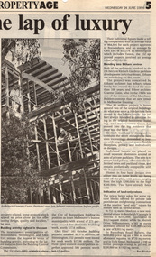
Document - Newspaper clipping, "The lap of luxury; Blending into Eltham environ", Property Age, The Age, Wednesday 24 June 1998, p5, June 1998
... Ian Jelbart always intended to continue living in the original homestead building, and now Graeme Gunn has moved into the big residence that once was the barn. ...Ian Jelbart always intended to continue living in the original homestead building, and now Graeme Gunn has moved into the big residence that once was the barn. ...Both of the architects involved in the 2.4-hectare Kinloch Gardens parkland development in Arthur Street, Eltham, are now living on the estate. The project was conceived by Eltham architect Ian Jelbart, whose family has owned the land for more than 100 years, and fellow architect Graeme Gunn, who in the 1960s was one of the creators of the Merchants Builders concept that set new trends in Melbourne housing. The $5 million project is based around two of the original buildings, on what was once a 100-hectare farm owned by the Jelbart family. Ian Jelbart always intended to continue living in the original homestead building, and now Graeme Gunn has moved into the big residence that once was the barn. Kinloch Gardens is designed to combine the more manageable land sizes increasingly demanded by buyers with ample "internal space, flexible floorplans, privacy and individuality of designs. Individual houses are placed on small separate allotments around an area of private parkland. The aim is to ensure total privacy, offer virtually unlimited views and parkland vistas, and remain aesthetically compatible with the local environment. Homes in four basic designs over either two or three levels are being sold off the plan, with prices ranging from the high $200,000s to the high $300,000s. Two have already been sold. Indication of land-only values The prices being asked for some vacant blocks offered for private sale provides an enlightening comparison of the relative "land only" values for homes sites in various areas. A 751 sq metre block on a new residential estate in Bentleigh/Carnegie is offered at $235,000, equivalent to $312/square metre; while in Merrett Drive, Williamstown, a 561 sq metre allotment offered for $169,000 carries a rate of $301/sq metre. In Barnsbury Road, Balwyn, the $450,000 price tag on a 584 sq metre allotment equates to $770 sq metre; and in York Street, Richmond, a 198 sq metre postage stamp is priced at $230,000 or $1162/sq metre. - Rex BookerDigital file only; created from scan undertaken by EDHS of item on loanarthur street, eltham, graeme gunn, houses, ian jelbart, jelbart property, kinloch gardens, rob maclellan, robert marshall, woodridge estate -
 Stawell Historical Society Inc
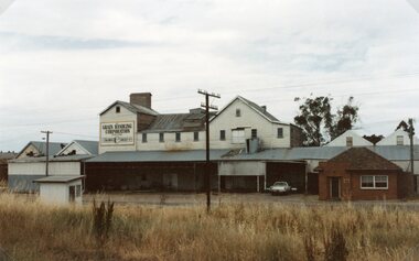
Photograph, Wimmera Flour Mill during Demolition -- Coloured
... Later years it sold clipped and graded seed, oats, stockfeed for poultry, pigs and dairy cattle and all types of crushed grain. The original Frayne homestead still stands behind where the Mill stood facing Frayne Street. ...Later years it sold clipped and graded seed, oats, stockfeed for poultry, pigs and dairy cattle and all types of crushed grain. The original Frayne homestead still stands behind where the Mill stood facing Frayne Street. ...Various colour photos of Wimmera Flour Mill at time it was being demolished. Note roof being dismantled. Rail line in foreground. Willaim Frayne founded the Wimmera Flour Mill on a site in Taylor Street (beside the railway line) Stawell 1876. When Willian Frayne dies 1899 his son George took over the mill. The mill continued to be a propriety company until early 1966, when it was sold to the Victorian Mill Owners. The sale was forced because of the lack of export markets. A factor which affected most country mills. The Victorian Oat Growers Pool took over on July 1st, 1967. Trading under the name of Wimmera Flower Mill as a subsidiary company. Later years it sold clipped and graded seed, oats, stockfeed for poultry, pigs and dairy cattle and all types of crushed grain. The original Frayne homestead still stands behind where the Mill stood facing Frayne Street. In 2007 during our "Collection Review" the four smaller colour photos, which were donated by Mr. Mick Walsh, 52 Patrick St Stawell were very similar to the bigger photo in the file 139.6e.139-6 a-d & e Coloured photographs showing various views of the Wimmera Flour Mill or Grain Handling Corporation building in progress of being demolished. There is a red brick building with a tiled roof in these coloured photos. The rail line is shown in foreground of 139-6 e. Our records on the data base show 139-6e to be a black & white photo but the same photo in the office folder is an enlarged colour photograph. Grain Handing Corporation stawell industry -
Warrnambool and District Historical Society Inc.
Document, Wollaston sale, 1919
... The sections for sale were Allotments 1, 18 and 19 which included the Wollaston Homestead. The original Wollaston property of 679 acres was selected by Thomas Manifold in the late 1840s. ...The sections for sale were Allotments 1, 18 and 19 which included the Wollaston Homestead. The original Wollaston property of 679 acres was selected by Thomas Manifold in the late 1840s. ...This is a poster advertising the sale of part of the Wollaston Estate in Warrnambool in 1919. The sections for sale were Allotments 1, 18 and 19 which included the Wollaston Homestead. The original Wollaston property of 679 acres was selected by Thomas Manifold in the late 1840s. This land, on the northern side of the Merri River, near the Woodford Road was three kilometres from the Warrnambool town. The first farmer we know who leased the property was William Simpson. Walter Manifold inherited the property and he took it over in 1884. The swing bridge he built in 1890 still stands today. In 1919 the Closer Settlement Board of Victoria acquired Wollaston and 17 lots were sold to returned soldiers for farming purposes. By 1930 there were only five soldier settlers remaining. In 2009 further subdivision took place with lots sold for residential purposes. The homestead allotments were sold separately in 1919 with various owners of the homestead itself recorded since that time. This poster is of interest as it shows the areas of the Wollaston Estate which were sold in 1919. The history of this estate is well-documented and of importance in the history of Warrnambool. This is a sheet of paper with red and black printing and a map of the Wollaston Estate which is photo-lithographed. The sheet has been folded three times. It has some small tears at the top of the page. wollaston, history of warrnambool, walter manifold -
 Ringwood and District Historical Society
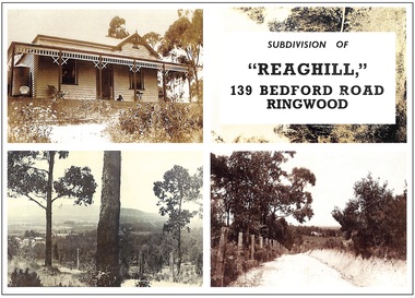
Archive, Richard Carter Collection - REAGHILL Subdivision Research (Parent Record)
... The “Reaghill” Homestead The original homestead on Wallace Bruce’s holding, as has just been described fronted Canterbury Road in the area which is now Rawson Court. ...The “Reaghill” Homestead The original homestead on Wallace Bruce’s holding, as has just been described fronted Canterbury Road in the area which is now Rawson Court. ...This record is the Parent Record for researching the subdivision of Reaghill, 139 Bedford Road, Ringwood, compiled by Richard Carter. "Reaghill" is part of an older larger holding of sixty acres which came to comprise Vista Avenue, Vista Court, Homebush Court, Rawson Court and Wombalano ParkTranscript: Researching “Reaghill" The property “Reaghill” originally stood at 139 Bedford Road, Ringwood East before the property was subdivided in the 1950s and took a new address and frontage to Vista Avenue, Ringwood East. The purpose of these notes is to trace the origins of the property from the year 1900 to the present day. Information in the notes is sourced from the archives of Carter Real Estate, from Land Titles Office records and from the book of the history of Ringwood, “Ringwood, Place of Many Eagles” by Hugh Anderson. “Reaghill” is part of an older larger holding of sixty acres. It Is the story of those 60 acres, which now comprise Vista Avenue, Vista Court, Homebush Court, Rawson Court and Wombalano Park, which Is the subject of these notes. Earlier Times A convenient starting point for these notes Is the year 1900. On 11th June 1900 Wallace Bruce of 68 High Street, Windsor became registered as the proprietor of “sixty acres or thereabouts” (24.28 hectares) being part of Crown Allotment 43 Parish of Ringwood County of Mornington. That title. Volume 2773 Folio 485 did not name the streets to which the property abutted but clearly they were Canterbury Road at its intersection with Bedford Road. Title records a lease of the property from Wallace Bruce to Thomas Oates, with the lease endorsed on title on 22 July 1903 and removed 16 June 1908. Wallace Bruce subsequently subdivided the land Into three parcels, two of which he sold to Dora Stanisforth Davies during 1909 and the balance he sold to Frank Leslie Walker in 1914. The Era of the Davies Wallace Bruce firstly sold the western portion of the property, containing twenty four acres three roods and 20 perches (24.875 acres or 10.0667 hectares) on 6 October 1909. The new title, Volume 3381 Folio 021, records the new proprietor as “Dora Stanisforth Davies, wife of Seymour George Pilkington Davies of Burwood Road, Hawthorn, Bank Manager”. Shortly thereafter, Wallace Bruce sold a further parcel of “ten acres or thereabouts” (4 hectares) being the north eastern portion of his original holding. That title, Volume 3384 Folio 795, showed the purchaser once again as “Dora Stanisforth Davies, wife of Seymour George Pilkington Davies of Burwood Road Hawthorn, Bank Manager”. It is noteable that the second, title which is dated 8 December 1909, had no abuttal to any road, nor was it at any time (even when subdivided in the 1950s) consolidated with Davies' adjoining title. Both titles then recorded that Dora Stanisforth Davies died on 19 February 1945 with probate of her will being granted to John Seymour Davies of 69 Grantham Street West Brunswick, Medical Practitioner, and Hugh Percival Hall of 339 Collins Street Melbourne, Solicitor. Almost two years later, on 6th December 1946, both parcels of land were transferred by the Executors to Geoffrey Francis Seymour Davies of 20 Albert Road Strathfield N.S.W, Medical Practitioner. From this chronology it could be surmised that one of Dora Davies’ executors, John Seymour Davies, was probably her son. Was Geoffrey Francis Seymour Davies another son, or was he her grandson? In any event Geoffrey Francis Seymour Davies set about subdividing what was then the property “Reaghill” and its 34.875 acres (14.11 hectares). The Subdivision of “Reaghill The subdivision of “Reaghill” was made more viable by the subdivision in 1931 of the property to the north and the creation of Scenic Avenue, Vista Avenue and Grandview Avenue, all of which abutted “Reaghill’s” northern boundary. In fact Geoffrey Francis Seymour Davies bought the freehold to Grandview Avenue, Scenic Avenue and Vista Avenue in July 1955 for £84-9-0 to give him legal rights over those roads. Title to those roads and the newly created Vista Avenue, Vista Court and Homebush Court remain in his name to this day. It is particularly interesting to note that whilst those streets had typical allotments of about 1000 square metres, the subdivision of Reaghill was into blocks of one to two acres or more (4000 square metres to about one hectare) except for the blocks fronting Bedford Road. That speaks volumes about Davies’ attitude to the land, its natural beauty, its topography and vegetation. “Reaghill” was subdivided into twenty two lots by Plan of Subdivision LP 41463. The first eleven lots came off Vista Avenue and formed an extension of Vista Avenue and a newly created Vista Court. Lot sizes ranged from 1 acre 1 rood 1½ perches (5097 square metres) to 2 acres 3 roods 21½ perches (1.167 hectares). A further four lots came off Homebush Court, a newly created court off Bedford Road. Those lots ranged from 1 acre 1 rood 29 perches (5792 square metres) to 2 acres 1 rood 39 ®/io perches (1.01 hectares). Seven further lots, parallelogram in configuration, fronted Bedford Road and had a typical area of 1518 square metres. The names of the streets (“Vista” Avenue/Court and “Homebush” Court) give an insight into the elevation of the land, the views it offered and the bushland it featured. The Covenant As evidence of Davies’ desire to maintain the bush setting of the property, covenants were imposed on the transfers of Lots 1 to 15 (the acreage lots). That covenant allowed for only one dwelling house to be erected on each of those lots for a period of 15 years from sale. Effectively it froze subdivision for 15 years. But 15 years came around quickly. The Sales “Reaghill” 139 Bedford Road, Ringwood was offered for Private Sale as “22 Excellent Residential Allotments” by estate agents Anderson & Hickling of 239 Collins Street Melbourne (telephone Central 25!), with a “protective covenant” of one dwelling house only on lots 1-15 for a period of 15 years. Solicitors for the vendor were Messrs Meares, Duigan & Hall of 139 Collins Street Melbourne. Sales commenced in 1955 and went through to 1967. Prices were typically from £1350, the price paid for Lot 13 in 1957. The Role of Frank Leslie Walker These notes have so far recorded that of the sixty acres originally owned by Wallace Bruce in 1900, some 34.875 acres were sold to Dora Davies in 1909 and subdivided and sold by her descendants. The balance of Wallace Bruce’s land was sold on 6th April 1914 to Frank Leslie Walker. This is the land at the south east corner of Bruce’s holding fronting Canterbury Road and which now comprises Rawson Court and Wombalano Park. Frank Leslie Walker “of Albany Chambers, Collins Street Melbourne” was described as an Art Decorator. In “Ringwood - Place of Many Eagles” he is shown as living on his land “in a house which was surrounded by a four foot high brick wall and the long drive of rough cream-coloured Lilydale gravel was entered through handsome wrought iron gates obtained from some building wrecker”. The “old rambling house" had been extended and renovated using secondhand doors, windows and timber. “Every inch of wall space seemed to be crammed from floor to ceiling with oils, watercolours, etchings and drawings of all sorts by well known artists”. On 13th August 1954 Frank Leslie Walker transferred an area of 12 acres 3 rood 21 perches (5.213 hectares) to The Mayor Councillors and Burgesses of the Borough of Ringwood for no consideration as a Gift “for the providing of pleasure grounds on places of public resort or public recreation”. That is now Wombalano Park. The balance of his property, containing 6 acres 1 rood 5 perches (2.54 hectares) and including the original homestead (named Wombalano?) was gifted by Frank Leslie Walker to his nephew on 25 November 1955. It was later subdivided as Rawson Court in 1956. The house no longer survives. The “Reaghill” Homestead The original homestead on Wallace Bruce’s holding, as has just been described fronted Canterbury Road in the area which is now Rawson Court. The age of the house is unknown but is described in 1914 as being “old and rambling”. The “Reaghill” homestead is likely to have been built by the Davies and was retained on Lot 11 of their subdivision. Its date of construction is not known but might have been soon after the Davies bought the land in 1909. Lot 11, with “Reaghill” was not sold in the 1950s as part of the land subdivision and sale. It remained as the family home of Dr. Davies until its sale in 1968 (without the 15 year covenant) to James Hamilton Kelly of New York, USA for $15,000. In time, Lot 11 was resubdivided. The house today remains on a reduced site of 7112 square metres, still on the highest point in the locality with fine views. Further Subdivisions Once the 15 year time frame of the covenant expired, the various owners of the lots, having built homes, proceeded to subdivide their surplus land. Lot 1 was first, followed by Lot 7. Only four of the original 15 acreage lots have not been subdivided. Some subdivisions were less respectful of their environment and neighbourhood than others. Maroondah City Council's planning scheme provides for a minimum lot size of 864 square metres in the locality. But the horse has already bolted. Summary “Reaghill” in its heyday, and the acreage properties which later surrounded it, contributed some of the finest and most exclusive properties in Ringwood East. Notably, the locality was home to a significant number of local medicos over the years. Its location dose to the newly relocated Tintern CEGGS gave it added exclusivity. Subdivision over the years has impinged on the beauty and the environment. However it is still a most important part of Ringwood East, with a rich history. R.A Carter January 2005 -
 Warrnambool and District Historical Society Inc.
Document (Sketch Plan of Dunmore), Stan Baulch, 1972
... original Rose Park property. Stan Baulch was a long time member of the Warrnambool & District Historical Society and he contributed many local history articles and donated many local artefacts to the Society. This sketch plan is of interest as it tells us what the historic homestead ...This card has a sketch map showing the properties surrounding Dunmore on one side and a detailed sketch plan of Dunmore homestead in the early 1970s on the other side. The plan of Dunmore homestead shows interesting features such as the brick oven for bread making, the croquet lawn, the site of the aboriginal mia mias, the Turkish baths and the fowl house used later as a poison house. Francis and Ann Baulch were pioneer settlers in the Kirkstall area and their son Samuel worked at Dunmore in the Macarthur area before purchasing in the early 1870s the property he named Rose Park. In the 1890s he acquired property in the Dunmore estate and his son Stan Baulch gained a section of the Dunmore property after his father’s death. Stan Baulch named this Dunmore section, Rose Park, a property to the west of his father’s original Rose Park property. Stan Baulch was a long time member of the Warrnambool & District Historical Society and he contributed many local history articles and donated many local artefacts to the Society.This sketch plan is of interest as it tells us what the historic homestead of Dunmore in Western Victoria was like in the early 1970s. It will be useful for research. This is a sheet of white lightweight cardboard with a pencilled sketch on one side and a blue ink sketch plan of a house on the other side. The edges of the card have some torn sections. The card is enclosed in an oval cardboard cylinder (recycled and torn at the ends). Both the card and the cover have handwritten titles in ink. Dunmore Homestead & History by S. Baulch Dunmore Homestead drawn by Stan Baulch c.1972 dunmore property, western victoria, baulch family -
 Kiewa Valley Historical Society
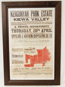
Poster - Framed - Kergunyah
... Kiewa Valley Historical Society Mount Beauty Information Centre 31 Bogong High Plains Rd Mt Beauty high-country in 1922 Kergunyah Park homestead was built by David Wallace in the late 1800's and remained in the family until the sale in 1922 when it was bought by John Woodside (grandfather of Ewen Wallace) whose family retained it until 1938. Another family named Wallace bought the property in 1938 and this family's descendants are still running it in 2005. David and Henrietta Wallace purchased the original ...in 1922 Kergunyah Park homestead was built by David Wallace in the late 1800's and remained in the family until the sale in 1922 when it was bought by John Woodside (grandfather of Ewen Wallace) whose family retained it until 1938. Another family named Wallace bought the property in 1938 and this family's descendants are still running it in 2005.David and Henrietta Wallace purchased the original holding and built Kergunyah Park homestead in the late 1800's running cattle on the property. They arrived in Australia in 1867 with their 3 children and were early settlers in the district. Their descendants still live in the district. Their family demonstrates how properties were passed on to the next generation. The poster is an example of the advertising of the sale of land in 1922, the size of land & blocks and the conditions of sale at the time.Large cloth map mounted under glass with a brown wooden frame. Brown writing detailing Kergunyah Park 1923 Sale Record. Includes 4 rectangular brown and white photos and a red map showing 13 blocks of land. Has hanging wire attached on the back."Framed by / Clarkson Collection / Ph; 02 6059 6800"kergunyah. kiewa valley. kergunyah park homestead. ewen wallace. john woodside.