Showing 10 items matching "pennyweight flat"
-
 Federation University Historical Collection
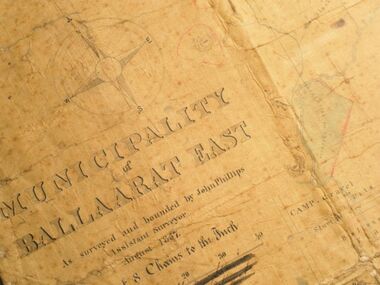
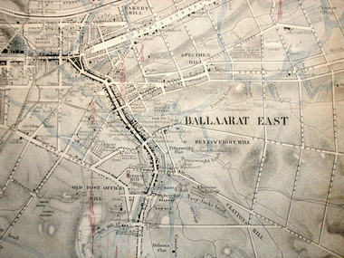
Map, Municipality of Ballarat East, 1857
... ...pennyweight flat...The map has read and blue highlights, and identifies areas such as Mount Pleasant, Golden Point, White Flat, Nightingale, Malekoff, Old Post Office Hill, Red streak, Gumtree Flat, Old Gravelpits, Bakery Hill, Ballaarat Flat, The Camp, Specimen Gully, Pennyweight Hill, Warrenheip Gully, Gays Gully, Pennyweight Flat, Eureka, Black Hill, Pinchgut, Crocodile, Hit or Miss, Little Bendigo, Brown Hill, Mopoke, Cricket Reserve, Canadian Hotel, Ballarat East...The map has read and blue highlights, and identifies areas such as Mount Pleasant, Golden Point, White Flat, Nightingale, Malekoff, Old Post Office Hill, Red streak, Gumtree Flat, Old Gravelpits, Bakery Hill, Ballaarat Flat, The Camp, Specimen Gully, Pennyweight Hill, Warrenheip Gully, Gays Gully, Pennyweight Flat, Eureka, Black Hill, Pinchgut, Crocodile, Hit or Miss, Little Bendigo, Brown Hill, Mopoke, Cricket Reserve, Canadian Hotel, Ballarat East Municipality of Ballarat East, 1857 Map Map ...Gold was discovered in Ballarat in 1851. This plan was created six years later and names some of the great gold locations of Ballarat East. It also shows the locality of the Eureka Stockade (1854) and the walking tracks and roads on the Ballarat East Goldfield.In 2007 this map was listed on the inaugural Ballarat Treasure's Register.Large map backed onto linen. The map has read and blue highlights, and identifies areas such as Mount Pleasant, Golden Point, White Flat, Nightingale, Malekoff, Old Post Office Hill, Red streak, Gumtree Flat, Old Gravelpits, Bakery Hill, Ballaarat Flat, The Camp, Specimen Gully, Pennyweight Hill, Warrenheip Gully, Gays Gully, Pennyweight Flat, Eureka, Black Hill, Pinchgut, Crocodile, Hit or Miss, Little Bendigo, Brown Hill, Mopoke, Cricket Reserve, Canadian Hotel, Ballarat Eastmount pleasant, golden point, white flat, nightingale, malekoff, old post office hill, red streak, gumtree flat, old gravelpits, bakery hill, ballaarat flat, the camp, specimen gully, pennyweight hill, warrenheip gully, gays gully, pennyweight flat, eureka, black hill, pinchgut, crocodile, hit or miss, little bendigo, brown hill, mopoke, cricket reserve, canadian hotel, ballarat eastm phillips, john phillips, field draughtsman, ballarat east, ballarat east map -
 Federation University Historical Collection
Plan, Plan of Leads and Gold Workings at Baallarat Showing the Complications Under the Frontage System, 1863, 1863
... ...pennyweight flat...Barker Library (top floor) Mount Helen goldfields Facsimile of a plan held by the Public Record Office Victoria. ballarat mining inkermann lead golden point lead robert davidson terrible lead white horse lead frenchman's lead little magpie lead milkmaid's lead woolshed lead nuggety lead blackman's lead canadian lead sailor's gully lad nightingale lead malakoff lead black hill gully pennyweight flat black hill winter's pre-emptive right nelson company great extended great republic lead cgt Facsimile of a plan of Ballarat showing leads, gold workings an dthe frontage system. ...Facsimile of a plan held by the Public Record Office Victoria. Facsimile of a plan of Ballarat showing leads, gold workings an dthe frontage system.ballarat, mining, inkermann lead, golden point lead, robert davidson, terrible lead, white horse lead, frenchman's lead, little magpie lead, milkmaid's lead, woolshed lead, nuggety lead, blackman's lead, canadian lead, sailor's gully lad, nightingale lead, malakoff lead, black hill gully, pennyweight flat, black hill, winter's pre-emptive right, nelson company, great extended, great republic lead, cgt -
 Federation University Historical Collection
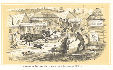
Print - Images, Unbound Images from Withers' 'History of Ballarat', c1987
... ...pennyweight flat...Barker Library (top floor) Mount Helen goldfields mail coach eureka graves ballaarat old cemetery mining registrar's office reward posters lake wendouree bakery hill madame berry gold mining company ballarat from bath's hotel quartz crushing black hill horse puddler pennyweight flat aborigines creswick withers william b. withers history of ballarat Copies of all images from the 1887 version of Withers' 'History of Ballarat'. ...Copies of all images from the 1887 version of Withers' 'History of Ballarat'. The images include copies of the Eureka Stockade reward posters. mail coach, eureka graves, ballaarat old cemetery, mining registrar's office, reward posters, lake wendouree, bakery hill, madame berry gold mining company, ballarat from bath's hotel, quartz crushing, black hill, horse puddler, pennyweight flat, aborigines, creswick, withers, william b. withers, history of ballarat -
 The Beechworth Burke Museum
Photograph, unknown
... This reproduced photograph is of Pennyweight Flat near Beechworth, a notable area of the 1850's gold rush in Victoria. ...The Beechworth Burke Museum Loch Street Beechworth high-country This reproduced photograph is of Pennyweight Flat near Beechworth, a notable area of the 1850's gold rush in Victoria. ...This reproduced photograph is of Pennyweight Flat near Beechworth, a notable area of the 1850's gold rush in Victoria. Donald Fletcher, migrating to Beechworth from Scotland in 1855, had substantial claims at Pennyweight Flat and was amongst the first in the district to utilise hydraulic sluicing and water diverting methods.The flat is said to have seen a flurry of 200 miners to the area around 1857, and by 1861 when work commenced on extending Fletcher's tail race the census recorded 644 people residing there (European males, females and Chinese).The search for gold is ingrained into the history of Victoria and therefore, images like this one which portray an open cut sluicing site can reveal important information for society and technology for the date when the photograph was taken. This image is of important historical significance for its ability to convey information about sluicing and the methods used to find gold in 1910. It also shows a location where sluicing was undertaken which provides insight into the impact of sluicing on the environment at a time when it was done. This image is important for current research into the history of Beechworth and surrounding area including Victoria's North East. The Rocky Mountain Extended Gold Sluicing Company was a long running and very active mine that was one of the most successful and largest in the district. Therefore, this image has the capacity to be beneficial for research into society and the motivations of those living and working in this region during this period and therefore, has social significance. The Beechworth Burke Museum has additional images relating to gold sluicing which can be analysed and studied alongside images like this one. When the mine closed in 1921, in a liquidation sale, Zwar purchased the tunnel and clear water supply that ran under the town of Beechworth. He directed the water to his tannery and over time built a major industry in leather works that was a major employer in Beechworth. In growing his leather business, Zwar installed crude oil engines for electricity in his factory. He oversaw working with local council to introduce electricity to Beechworth via a sub-station on Albert Street. In 1927 Electric street lamps replaced gas lamps in the streets of Beechworth. Black and white rectangular reproduced photograph printed on glossy photographic paperObverse: Reverse: 84.222.5/ digital print/ rocky mountain extended gold sluicing company, gold, sluicing, gold sluicing, hydraulic sluicing, gold mine, open cut mining, mining, gold mining, north-east victoria, beechworth, burke museum -
 Bendigo Historical Society Inc.
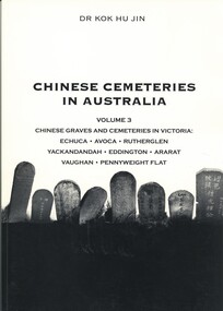
Book - CHINESE CEMETERIES IN AUSTRALIA, VOLUME 3. CHINESE GRAVES AND CEMETERIES IN VICTORIA, 2003
... Chinese Graves and Cemeteries in Victoria: Echuca, Avoca, Rutherglen, Yackandandah, Eddington, Ararat, Vaughan, Pennyweight Flat. Publisher: Golden Dragon Museum, Bendigo. ...Chinese Graves and Cemeteries in Victoria: Echuca, Avoca, Rutherglen, Yackandandah, Eddington, Ararat, Vaughan, Pennyweight Flat. Publisher: Golden Dragon Museum, Bendigo. ...Chinese Cemeteries in Australia, Volume 3. Chinese Graves and Cemeteries in Victoria: Echuca, Avoca, Rutherglen, Yackandandah, Eddington, Ararat, Vaughan, Pennyweight Flat. Publisher: Golden Dragon Museum, Bendigo. ISBN: 09578013 7 8. 93 pages. Black and white illustrations & map.Dr Kok Hu Jincemetery, chinese, bendigo cemeteries victoria, chinese graves, genealogy -
 Federation University Historical Collection
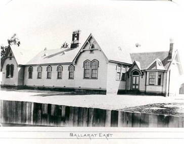
Photograph - Photograph - black and white, Ballarat East State School (No 1071)
... According to 'Visions and Realisations' The Eureka gold lead opened in August 1852, running from Little Bendigo, south beneath Yarrowee Creek into Pennyweight flat, where it was joined 100 yards or so from the intersection of main and Eureka Streets by the Canadian Lead. ...According to 'Visions and Realisations' The Eureka gold lead opened in August 1852, running from Little Bendigo, south beneath Yarrowee Creek into Pennyweight flat, where it was joined 100 yards or so from the intersection of main and Eureka Streets by the Canadian Lead. ...The weatherboard Ballarat East State School SS 1071 was formerly known as Specimen Hill. According to 'Visions and Realisations' The Eureka gold lead opened in August 1852, running from Little Bendigo, south beneath Yarrowee Creek into Pennyweight flat, where it was joined 100 yards or so from the intersection of main and Eureka Streets by the Canadian Lead. State School 1071 was formerly known as Ballarat Common School No. 71, and was founded by the Free Presbyterian Church on Specimen Hill in Eureka Street, Ballarat on 01 January 1854. On 20 May 1869 the trustees of the Presbyterian School, Specimen Hill, Ballarat, consented to the transfer of the site to the Board of Education. On 01 September 1870, Specimen Hill, Ballarat, was vested in the Board and then became known as SS 1071. On 01 March 1879 the Minister, The Hon. William Collard Smith, and William Dobbie, Inspector of School Buildings, visited Ballarat to report on the buildings with a view to extensions and renovations. The minister issued instructions for the old wooden part of the school to be demolished, and brick additions to be erected, so that the whole premises would accommodate 350 students. (''Visions and Realisations: A Century of State Education in Victoria, Vol. 2'', Education Department of Victoria, 1973, p 729-730.)Black and white photograph of a weatherboard school with shingle roof known as Ballarat East (SS1071). The building has a brick chimney and bell tower. This school has Castlemaine flagging in the passages.ballarat east state school, education, st paul's school, specimen hill state school -
 Bendigo Historical Society Inc.
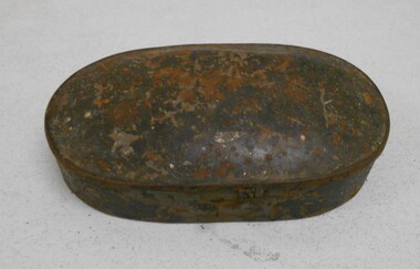
Tool - WEIGHTS FOR WEIGHING GOLD
... Rectangular 1 pennyweight weights (brass lozenge apothecary style weights ) through to round, flat 2 ounces. ...Rectangular 1 pennyweight weights (brass lozenge apothecary style weights ) through to round, flat 2 ounces. ...Brass weights used for weighing gold. Smallest weights a 4 'grain' and 5 'grain' square weights. Rectangular 1 pennyweight weights (brass lozenge apothecary style weights ) through to round, flat 2 ounces. Weights enclosed in an oval shaped tin with side clasp.gold mining, scales, brass weight for weighing gold -
 Federation University Historical Collection
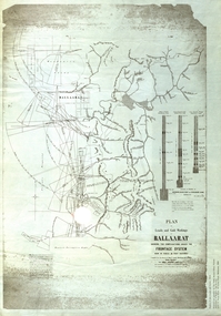
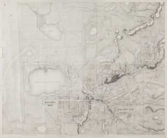
Map, Ballaarat Gold Field, 1861, 1861
... pennyweight hill...clayton hill...soldiers hill...golden point...gum tree flat...In November 2004 the Central Highlands Regional Library presented a special edition of 200 copies of the 1861 map reproduced from a copy in their collection. ballarat map ballarat east lake wendouree survey mines robert davidson ballarat gold field 1861 yuille's swamp wendouree swamp little bendigo diggings gold leads old post office hill specimen hill bakery hill black hill dead horse creek brown hill pennyweight hill clayton hill soldiers hill golden point gum tree flat white flat poverty hill chinese village robert brough smyth Ballarat map 1861 Ballaarat Vineyard Dead Horse Gully Deadhorse Creek Invermay Black Hill Flat Gaelic Church Police Reserve Magpie Range Dalton's Flat Caadian Lead Rifle Butts Powder Magazine Bathing House Government Camp Gold Office Chinese Llanberrris Victoria Theatre Charlie Napier Hotel United States Hotel Grape's Hoel Clayton's Hill Cattleyard Hill Free Trade Hotel Esmond Lead Bakery Hill Black Hill Lead Juvenile Reformatory Ballarat Orphanage Lady Barkly Lead Triffet's Slaughter Yard Little Bendigo Melbourne Road T. ...A party of surveyors camped by Yuille's Swamp (later Lake Wendouree) and surveyed the countryside for a map to be produced by the Geological Survey of Victoria. In November 2004 the Central Highlands Regional Library presented a special edition of 200 copies of the 1861 map reproduced from a copy in their collection. Original 1861 map of Ballarat showing streets and leads. Blue dots indicate gold leads, and red lines indicate auriferous quartz reef and outcrops of quartz veins."Compiled & Drawn from the Survey of Mining Surveyors Davidson, Fitzpatrick and Cowan & the Plans in the Surveyor General's Office by J. Brahe, 21st October 1861. R. Brough Smyth, Secretary for Mines. The Honourable J.B. Humffray, M.L.A. Commr of Mines.”ballarat, map, ballarat east, lake wendouree, survey, mines, robert davidson, ballarat gold field 1861, yuille's swamp, wendouree swamp, little bendigo diggings, gold leads, old post office hill, specimen hill, bakery hill, black hill, dead horse creek, brown hill, pennyweight hill, clayton hill, soldiers hill, golden point, gum tree flat, white flat, poverty hill, chinese village, robert brough smyth, ballarat map 1861, ballaarat vineyard, dead horse gully, deadhorse creek, invermay, black hill flat, gaelic church, police reserve, magpie range, dalton's flat, caadian lead, rifle butts, powder magazine, bathing house, government camp, gold office, chinese, llanberrris, victoria theatre, charlie napier hotel, united states hotel, grape's hoel, clayton's hill, cattleyard hill, free trade hotel, esmond lead, bakery hill, black hill lead, juvenile reformatory, ballarat orphanage, lady barkly lead, triffet's slaughter yard, little bendigo, melbourne road, t. cowan, thomas cowan -
 Federation University Historical Collection
Map, Ballaarat Gold Field, 1861, 21/10/1861
... pennyweight hill...claytons hill...golden point...mining...railway...cricket ground...swamp creek...cemetery...sludge reserve...bakery hill...gaelic church...juvenile reformatory...orphanage...specimen hill...eureka lead...cattle yard hill...dalton's flat...In November 2004 the Central Highlands Regional Library presented a special edition of 200 copies of the 1861 map reproduced from a copy in their collection. ballarat map davidson robert brough-smyth fitzpatrick cowan yuille's swamp public garden reserve manure depot black hill ballarat east old post office hill pennyweight hill claytons hill golden point mining railway cricket ground swamp creek cemetery sludge reserve bakery hill gaelic church juvenile reformatory orphanage specimen hill eureka lead cattle yard hill dalton's flat chinese village poverty hill railway reserve little bendigo diggings pound reserve allied armies flour mill agricultural reserve marsh survey reserve survey corps white flat yarrowee yarrowee creek brache j. brache survey ballaarat gold field 1861 Compiled & Drawn from the Survey of Mining Surveyors Davidson, Fitzpatrick and Cowan & the Plans in the Surveyor General's Office by J. ...A party of surveyors camped by Yuille's Swamp (later Lake Wendouree) and surveyed the countryside for a map to be produced by the Geological Survey of Victoria. In November 2004 the Central Highlands Regional Library presented a special edition of 200 copies of the 1861 map reproduced from a copy in their collection. Original geological map of Ballarat showing property, waterways, mines, churches, schools, water races, and garden reserves. It was compiled and drawn from the surveys of Mining Surveyors Davidson, Fitzpatrick and Cowan.Compiled & Drawn from the Survey of Mining Surveyors Davidson, Fitzpatrick and Cowan & the Plans in the Surveyor General's Office by J. Brahe, 21st October 1861. R. Brough Smyth, Secretary for Mines. The Honourable J.B. Humffray, M.L.A. Commr of Mines.ballarat, map, davidson, robert brough-smyth, fitzpatrick, cowan, yuille's swamp, public garden reserve, manure depot, black hill, ballarat east, old post office hill, pennyweight hill, claytons hill, golden point, mining, railway, cricket ground, swamp creek, cemetery, sludge reserve, bakery hill, gaelic church, juvenile reformatory, orphanage, specimen hill, eureka lead, cattle yard hill, dalton's flat, chinese village, poverty hill, railway reserve, little bendigo diggings, pound reserve, allied armies, flour mill, agricultural reserve, marsh, survey reserve, survey corps, white flat, yarrowee, yarrowee creek, brache, j. brache, survey, ballaarat gold field 1861 -
 Federation University Historical Collection
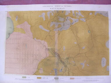
Map - Geological Survey, J. Phillips, Geological Survey of Victoria - Ballarat, 1857, 10/1858
... Pennyweight Hill...Clayton Hill...Ballaarat Cemetery...Bakery Hill...Specimen Hill...Soldiers Hill...Nightingale Lead...native youth black hill flat...Barker Library (top floor) Mount Helen goldfields ballarat geological geology Geological plan Main Road Camp Golden Point Pennyweight Hill Clayton Hill Ballaarat Cemetery Bakery Hill Specimen Hill Soldiers Hill Nightingale Lead native youth black hill flat White flat mining mines Eureka Lead Old Post Office Hill Geological map of the Ballarat District featuring four colours. ...Geological map of the Ballarat District featuring four colours.ballarat, geological, geology, geological plan, main road, camp, golden point, pennyweight hill, clayton hill, ballaarat cemetery, bakery hill, specimen hill, soldiers hill, nightingale lead, native youth black hill flat, white flat, mining, mines, eureka lead, old post office hill