Showing 219 items matching "phillip island map"
-
 Phillip Island and District Historical Society Inc.
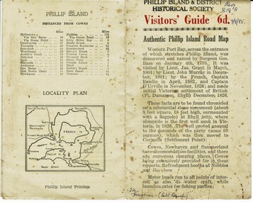
Booklet, Authentic Phillip Island Road Map, Pre 1960
... Authentic Phillip Island Road Map...Visitors' Guide 6d Authentic Phillip Island Road Map...Inside is a map of the Island with numbered points of interest. There is also a plan of Cowes and drawings of animals. Authentic Phillip ...Tourist brochure printed by the Phillip Island Printers pre 1960HistoricalSmall cream coloured brochure with details of accommodation, transport and animals. Inside is a map of the Island with numbered points of interest. There is also a plan of Cowes and drawings of animals.Visitors' Guide 6d Authentic Phillip Island Road Maptourist brochure, road map -
 Phillip Island and District Historical Society Inc.
Book, RMIT Cartography, Phillip Island : historical map series, 1991
... Phillip Island : historical map series...Phillip Island and District Historical Society Inc. phillip-island-and-the-bass-coast Stamped 'Phillip Island & District Historical Society'. Phillip Island : historical map ...Stamped 'Phillip Island & District Historical Society'. -
 Robin Boyd Foundation
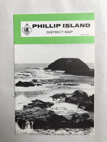
Map, RACV, Phillip Island District Map
... Phillip Island District Map...Robin Boyd Foundation 290 Walsh Street South Yarra melbourne Walsh St library Phillip Island District Map Map RACV ...walsh st library -
 Phillip Island and District Historical Society Inc.
Badge, Circular Cloth Badges
... Shire of Phillip Island. Map of Phillip Island, Penguin, Banksia & Eucalypt leaves. ...Phillip Island and District Historical Society Inc. phillip-island-and-the-bass-coast Badges issued by the Shire of Phillip Island prior to 1994 Historical Shire of Phillip Island Shire of Phillip Island. Map ...Badges issued by the Shire of Phillip Island prior to 1994Historical2 Circular Cloth Badges for Shire of Phillip Island - 1 printed and the other embroideredShire of Phillip Island. Map of Phillip Island, Penguin, Banksia & Eucalypt leaves. shire of phillip island -
 Phillip Island and District Historical Society Inc.
Photograph, Bryant West
... ...phillip island map...Photograph of an early Map of Phillip Island not drawn to scale. Copy from Records Office, London....On back of photo - "If used must bear acknowedgement - reproduced by permission of the Hydrographer of the Navy" "Received 18/3/1955 from London Records Office per Mr mcGrigor-Phillips" Printed on Map "Phillip Island"...Phillip Island and District Historical Society Inc. phillip-island-and-the-bass-coast One of a collection of over 400 photographs in an album commenced in 1960 and presented to the Phillip Island & Westernport Historical Society by the Shire of Phillip Island local history photography photographs maritime documents maps exploration john jenner bryant west phillip island map On back of photo - "If used must bear acknowedgement - reproduced by permission of the Hydrographer of the Navy" "Received 18/3/1955 from London Records Office per Mr mcGrigor-Phillips" Printed on Map "Phillip Island" Photograph of an early Map of Phillip Island not drawn to scale. ...One of a collection of over 400 photographs in an album commenced in 1960 and presented to the Phillip Island & Westernport Historical Society by the Shire of Phillip IslandPhotograph of an early Map of Phillip Island not drawn to scale. Copy from Records Office, London.On back of photo - "If used must bear acknowedgement - reproduced by permission of the Hydrographer of the Navy" "Received 18/3/1955 from London Records Office per Mr mcGrigor-Phillips" Printed on Map "Phillip Island"local history, photography, photographs, maritime documents, maps, exploration, john jenner, bryant west, phillip island map -
 Phillip Island and District Historical Society Inc.
Photographs, Kodak, Early 20th Century to mid 20th Century
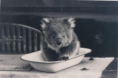
... ...phillip island map...Phillip Island with people standing around it. 293-08. Photograph of a family and children in front of car - unknown. 293-09. Photograph of a painting of "Innishowen" Harbison's Property. Mr Harbison's portrait inset on the painting. 293-10. Photograph of an early map...Phillip Island and District Historical Society Inc. phillip-island-and-the-bass-coast A collection of a group of photographs donated to the Society by Lun Blom, from the Photo Shop in Thompson Avenue, Cowes (was opposite the museum) wildlife - koala wildlife - whale the nobbies ploughing trophy cape woolamai - cleeland's house innishowen mr harbison phillip island map westernport hotel san remo fishing boat san remo pier couta boat westernport the two bridges san remo mutton bird eggers camp steam ferry fisherman's hut cowes lover's walk cowes aerial view of phillip island lyn blom 293-01. ...A collection of a group of photographs donated to the Society by Lun Blom, from the Photo Shop in Thompson Avenue, Cowes (was opposite the museum)A collection of 19 photographs of Phillip Island and surrounds. 293-01. Koala sitting in enamel bowl on table 293-02. 20 farmers having a break. 293-03. Reproduction of painting of The Nobbies. 293-04. Photograph of a Trophy for 1st prize for ploughing won by Mr L Morrison 1859. 293-05. Photograph of three men standing in front of a motor vehicle. 293-06. Photograph of view of Cleeland's House at Cape Woolamai. 293-07. Photograph of a whale beached on Phillip Island with people standing around it. 293-08. Photograph of a family and children in front of car - unknown. 293-09. Photograph of a painting of "Innishowen" Harbison's Property. Mr Harbison's portrait inset on the painting. 293-10. Photograph of an early map - possibly drawn by Bass & Flinders. 293-11. Photograph of the San Remo-Westernport Hotel, with vehicles in front. 293-12. Photograph of a fishing boat at the San Remo Jetty with the township in the background. 293-13. Photograph of a couta boat under full sail in Westernport. 293-14. Photograph of an aerial view of the Two Bridges taken from San Remo side. 293-15. Photograph of the Mutton Bird Eggers Camp - Bergins Bay Cape Woolamai. 293-16. Photograph of a Steam ferry decorated with flags. 293-17. Photograph of Fisherman's hut at Cowes with pier in the background. Possibly Mr Cox's. 293-18. Photograph of a couple standing on the bridge in Lover's Walk Cowes. 293-19. Photograph of an aerial view of Phillip Island looking towards Mornington Peninsula and the Heads to Port Phillip Bay in the distance.293-01. "Koala Pie" Cowes. 293-06. Mr Cleeland's Station. 293-09. "Innishowen" Mr. Harbison. 293-10. Phillip Island. 293-17. Phillip Island - Fisherman's Hut, Cowes. 293-18. Phillip Island - Lover's Walk, Cowes.wildlife - koala, wildlife - whale, the nobbies, ploughing trophy, cape woolamai - cleeland's house, innishowen, mr harbison, phillip island map, westernport hotel san remo, fishing boat san remo pier, couta boat westernport, the two bridges san remo, mutton bird eggers camp, steam ferry, fisherman's hut cowes, lover's walk cowes, aerial view of phillip island, lyn blom -
 Phillip Island and District Historical Society Inc.
Photographs-Postcards, Valentine Publishing Co. Pty. Ltd. et al, 1940's
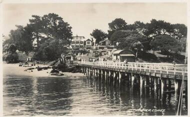
... bayview guest house cowes phillip island...map...Phillip Island. 357-08: Looking from the Cowes Pier towards the Isle of Wight Hotel. Shows camel rides on the beach. 357-09: Bayview Guest House on The Esplanade, Cowes. 357-10: A koala and young on tree. 357-11: Penguins coming in at dusk at the Penguin Parade. 357-12: Broadbent's Official Map of Phillip Island....Phillip Island. 357-12: Broadbent's Official Map. Phillip Island....Phillip Island. 357-12: Broadbent's Official Map. Phillip Island. ...Five of a collection of 12 photographs and postcards donated by Jill Palmer.Five black & white postcards taken around Phillip Island. 357-08: Looking from the Cowes Pier towards the Isle of Wight Hotel. Shows camel rides on the beach. 357-09: Bayview Guest House on The Esplanade, Cowes. 357-10: A koala and young on tree. 357-11: Penguins coming in at dusk at the Penguin Parade. 357-12: Broadbent's Official Map of Phillip Island.357-08: The Pier, Cowes. No. 9. 357-09: Photo Shop Series. Bayview Guest House. Cowes. 357-10: Native Bears (Koala) at Cowes No. 55B. 357-11: Photo Shop Series. Parade of the Penguins. Phillip Island. 357-12: Broadbent's Official Map. Phillip Island.cowes pier, cowes beach, wildlife - koalas, wildlife - penguins, bayview guest house cowes phillip island, map of phillip island -
 Phillip Island and District Historical Society Inc.
Photographs, Early 20th Century
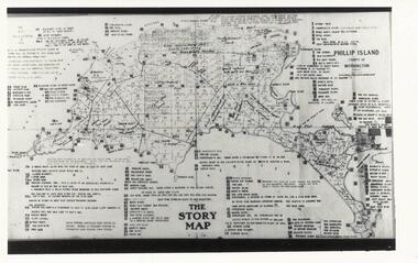
... phillip island map...Black & White photograph of The Story Map of Phillip Island with allotments shown and extremely detailed information typed on it by Vernon McHaffie. 234-02. ...Phillip Island and District Historical Society Inc. phillip-island-and-the-bass-coast Three photographs/postcards donated by J Gliddon phillip island map phillip island allotments vernon mchaffie wildlife - penguins penguins phillip island penguin rookeries phillip island j gliddon 234-02. ...Three photographs/postcards donated by J Gliddon234-01. Black & White photograph of The Story Map of Phillip Island with allotments shown and extremely detailed information typed on it by Vernon McHaffie. 234-02. Sepia postcard of the penguin rookery on "Little Nobby", Phillip Island. Man sitting on hill looking down at the rookery showing tracks & entrances to burrows. 234-03. Sepia postcard of two people sitting on top of cliff, Headland Rookery, with moulting penguins on their laps. 234-02. "Tom Tregellas" Nature Series No. 1. (Penguins) Phillip Island. Rookery on Little Nobby, showing tracks and entrances to burrows amongst the "pig-face" weed. 234-03. "Tom Tregellas" Nature Series No. 1. (Penguins) Phillip Island. Moulting Burrow on top of Cliff, Headland Rookery, which contained four birds. Note feathers outside burrow.phillip island map, phillip island allotments, vernon mchaffie, wildlife - penguins, penguins phillip island, penguin rookeries phillip island, j gliddon -
 Phillip Island and District Historical Society Inc.
Photograph
... ...phillip island map...Photograph of a geological map of Phillip Island...Phillip Island and District Historical Society Inc. phillip-island-and-the-bass-coast One of a collection of over 400 photographs in an album commenced in 1960 and presented to the Phillip Island & Westernport Historical Society by the Shire of Phillip Island local history photography phillip island map black & white photograph maps & mapping phillip island geology John Jenner Bryant West Photograph of a geological map of Phillip Island Photograph Bryant West ...One of a collection of over 400 photographs in an album commenced in 1960 and presented to the Phillip Island & Westernport Historical Society by the Shire of Phillip IslandPhotograph of a geological map of Phillip Islandlocal history, photography, phillip island map, black & white photograph, maps & mapping, phillip island, geology, john jenner, bryant west -
 Phillip Island and District Historical Society Inc.
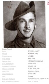
Photograph, Harry Bradley - Phillip Island Identity
... ...Phillip Island Map...Now Beachcomber Estate 491-04: Harry Bradley working on the 1st Phillip Island Bridge 491-05: Harry Bradley's parents - Father - Edwin and Mother who was killed by a bull 491-06: Harry Bradley - Equal 1st Competition at the Lang Lang Gun Club 491-07: Elsford Guest House - Post Card 491-08: Map of Phillip Island - Post Card Also DVD supplied with 491-01 to 06 on it....Phillip Island and District Historical Society Inc. phillip-island-and-the-bass-coast Harry Bradley was a local Identity. Born in Yorkshire, England, 8/4/1916. Joined the Australian Army 19/5/1941 living in Cowes Phillip Island Victoria. Historical Harry Bradley Ted Walton Edwin Bradley Lang Lang Gun Club Elsford Guest House Phillip Island Map ...Harry Bradley was a local Identity. Born in Yorkshire, England, 8/4/1916. Joined the Australian Army 19/5/1941 living in Cowes Phillip Island Victoria.Historical491-01: Harry Bradley an Australia Army Portrait - WWII 491-02: Harry Bradley & Ted Walton, very close fishing mates 491-03: Original House of Bradleys, opposite Race Track?? Ford Vehicle. Now Beachcomber Estate 491-04: Harry Bradley working on the 1st Phillip Island Bridge 491-05: Harry Bradley's parents - Father - Edwin and Mother who was killed by a bull 491-06: Harry Bradley - Equal 1st Competition at the Lang Lang Gun Club 491-07: Elsford Guest House - Post Card 491-08: Map of Phillip Island - Post Card Also DVD supplied with 491-01 to 06 on it.As Above with Harry's details listed on 491-01harry bradley, ted walton, edwin bradley, lang lang gun club, elsford guest house, phillip island map -
Phillip Island and District Historical Society Inc.
Photograph, Photo Map of Phillip Island
... Photo Map of Phillip Island...Map of Phillip Island...Map...Historical Map of Phillip Island Map Mornington Peninsula Keith Lukey len lukey Base map at PI 400' to 1" series Mornington Peninsula area Photo Map of Phillip Island Photograph ...Map donated by Keith Lukey & family. Keith is the son of Len Lukey who was the previous owner of the Grand Prix Track.HistoricalBase map at PI 400' to 1" series Mornington Peninsula areamap of phillip island, map, mornington peninsula, keith lukey, len lukey -
 Phillip Island and District Historical Society Inc.
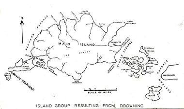
Photograph
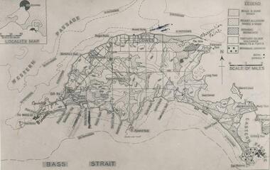
... phillip island...black & white photograph...phillip island geology...Map...Photograph of a map of Phillip Island in the making and showing fourteen separate Islands before natural processes joined them....Phillip Island and District Historical Society Inc. phillip-island-and-the-bass-coast One of a collection of over 400 photographs in an album commenced in 1960 and presented to the Phillip Island & Westernport Historical Society by the Shire of Phillip Island local history photography phillip island black & white photograph phillip island geology Map Dr G Baker John Jenner Bryant West Photograph of a map of Phillip Island in the making and showing fourteen separate Islands before natural processes joined them. ...One of a collection of over 400 photographs in an album commenced in 1960 and presented to the Phillip Island & Westernport Historical Society by the Shire of Phillip IslandPhotograph of a map of Phillip Island in the making and showing fourteen separate Islands before natural processes joined them.local history, photography, phillip island, black & white photograph, phillip island geology, map, dr g baker, john jenner, bryant west -
 Phillip Island and District Historical Society Inc.
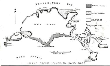
Photograph
... phillip island...black & white photograph...phillip island geology...map...Photograph of a map of Phillip Island showing a late stage in the geological formation...Phillip Island and District Historical Society Inc. phillip-island-and-the-bass-coast One of a collection of over 400 photographs in an album commenced in 1960 and presented to the Phillip Island & Westernport Historical Society by the Shire of Phillip Island local history photography phillip island black & white photograph phillip island geology map Map of Phillip Island John Jenner Bryant West Photograph of a map of Phillip Island showing a late stage in the geological formation Photograph Bryant West Dr G Baker ...One of a collection of over 400 photographs in an album commenced in 1960 and presented to the Phillip Island & Westernport Historical Society by the Shire of Phillip IslandPhotograph of a map of Phillip Island showing a late stage in the geological formationlocal history, photography, phillip island, black & white photograph, phillip island geology, map, map of phillip island, john jenner, bryant west -
 Phillip Island and District Historical Society Inc.
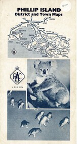
Map, Phillip Island District and Town Maps, 01/11/1967
... Map-Phillip Island and District Maps - Tourist guide to Phillip Island tourist sites. ...Historical Historical Society Map-Phillip Island and District Maps - Tourist guide to Phillip Island tourist sites. ...Map - PI District and Town Maps - Tourist brochure. Produced by the RSCV.HistoricalMap-Phillip Island and District Maps - Tourist guide to Phillip Island tourist sites. A3 page folded as a brochure. Blue print and photographs and advertisements.historical society -
 Bendigo Military Museum
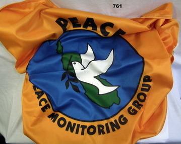
Flag - FLAG PEACE MONITORING, Screen Graphics, c.2000
... Bendigo Military Museum 37 - 39 Pall Mall Bendigo goldfields The item was brought back from Peace Monitoring in Bougainville by Phillip Chapman Australian Army. flags military peace keeping force Peace Monitoring Group Peace monitoring flag Bougainvillea, orange with white trim. A white dove holding black laurel branch on green Bougainvillea Island map, blue water in background. ...The item was brought back from Peace Monitoring in Bougainville by Phillip Chapman Australian Army.Peace monitoring flag Bougainvillea, orange with white trim. A white dove holding black laurel branch on green Bougainvillea Island map, blue water in background. Peace Monitoring Groupflags, military, peace keeping force -
 Eltham District Historical Society Inc
Book, Melway Publishing, Melway Greater Melbourne street directory : including Geelong, Phillip Island, Healesville, Kinglake, Gisborne, Lorne, Wallan, Bacchus Marsh Bellarine & Mornington Peninsulas; Edition 33, 2006, 2005
... Eastlink fully detailed new Craigieburn bypass GPS compatible WGS/MGA Grid Special feature: New Hierachy of Roads streets,roads,melbourne,map,melway Street directory with plastic cover, coloured maps, 902 pages Melway Greater Melbourne street directory : including Geelong, Phillip Island, Healesville, Kinglake, Gisborne, Lorne, Wallan, Bacchus Marsh Bellarine & Mornington Peninsulas; Edition 33, 2006 Book Melway Publishing ...Edition 33. 2006 Coloured detailed maps accessed by a street or location index. Cover: Totally revised and updated with over 1380 new street listings new maps covering Mount Duneed on the Bellarine Peninsula, Pakenham South and Rythdale. Detailed public transport routes - train, tram, bus, bicycle paths & shared road routes. Eastlink fully detailed new Craigieburn bypass GPS compatible WGS/MGA Grid Special feature: New Hierachy of Roads Street directory with plastic cover, coloured maps, 902 pagesstreets,roads,melbourne,map,melway -
 Phillip Island and District Historical Society Inc.
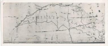
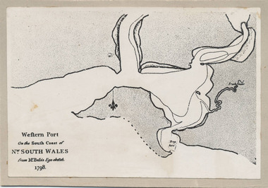
Photograph, Bryant West, 1798
... Photograph of the First Map of Phillip Island ever drawn. An eye sketch by Bass....Phillip Island and District Historical Society Inc. phillip-island-and-the-bass-coast One of a collection of over 400 photographs in an album commenced in 1960 and presented to the Phillip Island & Westernport Historical Society by the Shire of Phillip Island local history photography photographs exploration maritime documents maps george bass phillip island bryant west john jenner As written on front of map - "Western Port on the South Coast of Nw. ...One of a collection of over 400 photographs in an album commenced in 1960 and presented to the Phillip Island & Westernport Historical Society by the Shire of Phillip IslandPhotograph of the First Map of Phillip Island ever drawn. An eye sketch by Bass.As written on front of map - "Western Port on the South Coast of Nw. South Wales from GE Bass's Eye-sketch 1798"local history, photography, photographs, exploration, maritime, documents, maps, george bass, phillip island, bryant west, john jenner -
 Phillip Island and District Historical Society Inc.
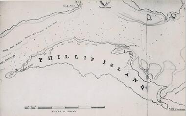
Photograph, Bryant West
... Photograph of a Map of Phillip Island. The first to show Fort Dumaresq, track to beach and beginning of road to South coast. ...Phillip Island and District Historical Society Inc. phillip-island-and-the-bass-coast One of a collection of over 400 photographs in an album commenced in 1960 and presented to the Phillip Island & Westernport Historical Society by the Shire of Phillip Island local history photography photographs exploration maritime documents maps phillip island john jenner bryant west Photograph of a Map of Phillip Island. ...One of a collection of over 400 photographs in an album commenced in 1960 and presented to the Phillip Island & Westernport Historical Society by the Shire of Phillip IslandPhotograph of a Map of Phillip Island. The first to show Fort Dumaresq, track to beach and beginning of road to South coast. local history, photography, photographs, exploration, maritime, documents, maps, phillip island, john jenner, bryant west -
 Phillip Island and District Historical Society Inc.
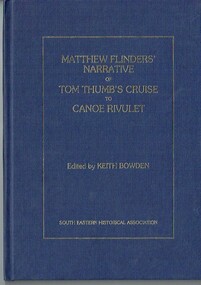
Book - Book, hardcover, Matthew Flinders' narrative of Tom Thumb's cruise to Canoe Rivulet, 1985
... Phillip Island and District Historical Society Inc. phillip-island-and-the-bass-coast Flinders recorded this "cruize" of the Tom Thumb in the form of a Narrative, together with his account of the Schooner Francis's expedition to the Furneaux Islands. matthew flinders tom thumb canoe rivulet keith bowden south eastern historical association pakenham gazette schooner francis furneaux islands navigation exploration xvii, 34 p., [1] leaf of plates : ill., facsims., map, ports. ; 26 cm. ...Flinders recorded this "cruize" of the Tom Thumb in the form of a Narrative, together with his account of the Schooner Francis's expedition to the Furneaux Islands.xvii, 34 p., [1] leaf of plates : ill., facsims., map, ports. ; 26 cm. matthew flinders tom thumb canoe rivulet keith bowden south eastern historical association pakenham gazette schooner francis furneaux islands, navigation exploration -
 Phillip Island and District Historical Society Inc.
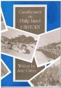
Book - Book, softcover, Guesthouses on Phillip Island : a history, 1987
... Phillip Island and District Historical Society Inc. phillip-island-and-the-bass-coast Historical Phillip Island Accomodation Guesthouses History Housing Julie Cutter 1987 Broadwater Guesthouse Cowes Phillip Island carisbrooke guesthouse cowes phillip island Bayview House osbourne park guesthouse phillip island erehwon guesthouse Isle of Wight Hotel 169 p. : ill., facsims., maps, plans ; 25 cm. ...Historical169 p. : ill., facsims., maps, plans ; 25 cm. ISBN 0731600088 phillip island, accomodation, guesthouses, history, housing, julie cutter, 1987, broadwater guesthouse cowes phillip island, carisbrooke guesthouse cowes phillip island, bayview house, osbourne park guesthouse phillip island, erehwon guesthouse, isle of wight hotel -
Phillip Island and District Historical Society Inc.
Book, Western Port chronology 1798-1839 : exploration to settlement, 1984
... Phillip Island and District Historical Society Inc. phillip-island-and-the-bass-coast Extracts from log books and journals of explorers and travellers from the time George Bass entered and sketched the harbour in 1798, combined with rare charts and plates. This compilation brings life to European activity at Western Port during the thirty-seven years that preceded Melbourne's founding. xiv, 110 p. : ill., facsims., maps ...Extracts from log books and journals of explorers and travellers from the time George Bass entered and sketched the harbour in 1798, combined with rare charts and plates. This compilation brings life to European activity at Western Port during the thirty-seven years that preceded Melbourne's founding. xiv, 110 p. : ill., facsims., maps ; 24 cm. ISBN 0959065202 -
 Phillip Island and District Historical Society Inc.
Photographs, Early 20th Century
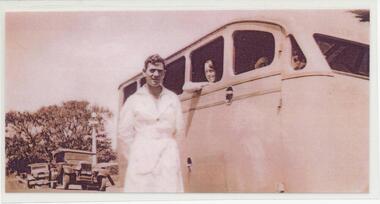
... Photograph of a Chev Tourist Bus - Phillip Island Tourist Service Cowes - at the Cowes Pier. 1947. 288-29. Photograph of the Cowes - Dandenong Road Service Brochure. A Koala on one side and map...Photograph of a Chev Tourist Bus - Phillip Island Tourist Service Cowes - at the Cowes Pier. 1947. 288-29. Photograph of the Cowes - Dandenong Road Service Brochure. A Koala on one side and map ...A collection of 27 photographs and 2 brochures of Tourists buses used during the 1930's to 1950's on Phillip Island. Also some photographs of penguins and mutton birds. Donated by Terry Watchorn. In reference to 288-17. A post on Facebook relating to this photo in Feb 2019 by Gwyneth Myers said “ there are some wonderful Knights restored amongst the Willy’s Car Club members”29 Photographs and Brochures of Tourist Buses, penguins and mutton birds. 288-01. Photograph of Herb Watchorn, driver, outside the bus. 288-02. Photograph of a new Ford Bus 1938. 288-03. Photograph of Herb Watchorn with a Mutton Bird. 288-04. Photograph of a 1946 Ford Car, new sheds with cars and house in Cowes. 288-05. Photograph of Elizabeth, Mary, Patricia and Herbet Watchorn outside Cora Lynn Guest House. 288-06. Photograph of a Chev Tourist Bus outside the Isle of Wight Hotel in Cowes. April 1935. Herb Watchorn & another man. 288-07. Photograph of a Tourist bus and passengers with a Bullock Team passing by. 1936. 288-08. Photograph of the Phillip Island Tourist Bus - "EY" Ford - used on the Dandenong Run. 288-09. Photograph of three 1946 Ford Buses, an Indiana Bus and a Chev. 288-10. Photograph of a Chevrolet bus 1934. 288-11. Photograph of a Ford Bus 1953. 288-12. Photograph of Herb Watchorn and Willys Knight Car. 288-13. Photograph of five buses - Chev, Indiana & Ford Buses. 288-14. Photograph of a Chev bus and passengers on the San Remo-Newhaven Punt. 1934. 288-15. Photograph of Herb Watchorn with a penguin. 288-16. Photograph of Bern Denham with a penguin. 288-17. Photograph of Willy's Knight at The Nobbies and a group of people. 288-18. Photograph of Herb Watchorn, passengers and Hudson at The Nobbies. 288-19. Photograph of a Chev Bus and passengers in the Esplanade, Cowes ? 288-20. Photograph of Herb Watchorn with passengers outside a bus. 288-21. Photograph of Bern Denham with a penguin. 288-22. Photograph of a penguin with young. 288-23. Photograph of Bern Denham with a penguin. 288-24. Photograph of Willys-Knight Sedan Car Service Tours and Price List. 288-25. Photograph of Bern Denham with a mutton bird. 288-26. Photograph of 3 Ford, an Indiana and Chev Buses in Cowes. 288-27. Photograph of Herb Watchorn outside a Ford Bus in front of The Isle of Wight Hotel - Feb 1941. 288-28. Photograph of a Chev Tourist Bus - Phillip Island Tourist Service Cowes - at the Cowes Pier. 1947. 288-29. Photograph of the Cowes - Dandenong Road Service Brochure. A Koala on one side and map on the other.All as above.tourist buses on phillip island, herb watchorn, wildlife - penguins, wildlife - mutton birds, bern denham, watchorn family, terry watchorn -
 Phillip Island and District Historical Society Inc.
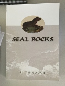
book, Ruth Gooch, Seal Rocks and Victoria's primitive beginnings, 2008
... Phillip Island and District Historical Society Inc. phillip-island-and-the-bass-coast seal rocks local aboriginal history sealing western port Stamped Phillip Island & District Historical Society ix, 166 p. : ill., maps, ports. ; 25 cm. ...ix, 166 p. : ill., maps, ports. ; 25 cm. Includes index. Bibliography: p. 151-159. Stamped Phillip Island & District Historical Societyseal rocks, local aboriginal history, sealing, western port -
 Phillip Island and District Historical Society Inc.
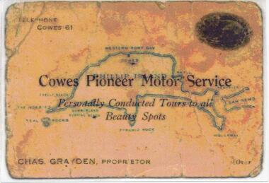
Photograph, 1925 - 1936
... Colour photograph of front of Charles Grayden's Business Card. Map of Phillip Island in the background. 2. Colour photograph of back of Charles Grayden's Business Card....phillip island 1. On Front: Telephone Cowes 61 - Cowes Pioneer Motor Service - Personally Conducted Tours to all Beauty Spots - Chas. Grayden, Proprietor - [over On Back: Business Card of Charles Grayden 1925 - 1936. 2. On Front: Personally Conducted Tours to all Beauty Spots including Nobbies & Summerland Surfing Beach, Newhaven, Forrest's Caves & Rhyll. Evening Trips to Mutton Bird & Penguin Rookeries. Agents for Ideal Summerland. Booking Office, opposite Pier, near Koala Cafe. 1. Colour photograph of front of Charles Grayden's Business Card. Map ...Two of a collection of 6 photographs donated by Anne Grayden. First photograph "Registration" No. 199-05 Second Photograph "Registration" No. 199-061. Colour photograph of front of Charles Grayden's Business Card. Map of Phillip Island in the background. 2. Colour photograph of back of Charles Grayden's Business Card.1. On Front: Telephone Cowes 61 - Cowes Pioneer Motor Service - Personally Conducted Tours to all Beauty Spots - Chas. Grayden, Proprietor - [over On Back: Business Card of Charles Grayden 1925 - 1936. 2. On Front: Personally Conducted Tours to all Beauty Spots including Nobbies & Summerland Surfing Beach, Newhaven, Forrest's Caves & Rhyll. Evening Trips to Mutton Bird & Penguin Rookeries. Agents for Ideal Summerland. Booking Office, opposite Pier, near Koala Cafe.charles grayden, cowes pioneer motor service, anne grayden, tourism phillip island -
 Phillip Island and District Historical Society Inc.
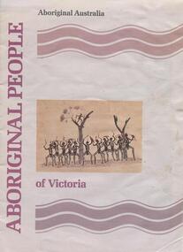
book, Aboriginal people of Victoria, 1990
... Phillip Island and District Historical Society Inc. phillip-island-and-the-bass-coast richard broome aboriginal people of victoria aboriginal australia. culture and society aboriginal australians -- australia -- victoria. aboriginal and torres strait islander commission Stamped: Phillip Island & District Historical Society 15 p. : ill. (some col.), map ...15 p. : ill. (some col.), map, ports. ; 30 cm. Cover title. Cat. no. 8907893. Bibliography: p. 15. ISBN 0644101547Stamped: Phillip Island & District Historical Societyrichard broome, aboriginal people of victoria, aboriginal australia. culture and society, aboriginal australians -- australia -- victoria., aboriginal and torres strait islander commission -
Phillip Island and District Historical Society Inc.
Book, Aboriginal string bags : nets and cordage, 1999
... Phillip Island and District Historical Society Inc. phillip-island-and-the-bass-coast fibers string craft australia rope aboriginal australians industries To The Phillip Island and District Historical Society, With best wishes, Alan West, July 2001 xv, 157 p. : ill., maps ; 24 cm. ...xv, 157 p. : ill., maps ; 24 cm. Occasional papers, Anthropology and History ; To The Phillip Island and District Historical Society, With best wishes, Alan West, July 2001fibers, string craft, australia, rope, aboriginal australians, industries -
Phillip Island and District Historical Society Inc.
Book, Aboriginal string bags : nets and cordage, 1999
... Phillip Island and District Historical Society Inc. phillip-island-and-the-bass-coast fibers string craft australia rope aboriginal australians industries Inscribed 'To Phillip Island & District Historical Society with best wishes from Alan West, January 2000'. xv, 157 p. : ill., maps ; 24 cm. ...xv, 157 p. : ill., maps ; 24 cm. Occasional papers, Anthropology and History ; Inscribed 'To Phillip Island & District Historical Society with best wishes from Alan West, January 2000'.fibers, string craft, australia, rope, aboriginal australians, industries -
Phillip Island and District Historical Society Inc.
Book, Broadbent's Official Road Guides Company, Broadbent's official guide : Gippsland and south-east corner of N.S.W. incorporating large scale maps, 1950
... Phillip Island and District Historical Society Inc. phillip-island-and-the-bass-coast victoria guidebooks J.P. Anderson, 97 Salmon St., Hastings' Broadbent's official guide : Gippsland and south-east corner of N.S.W. incorporating large scale maps. ...J.P. Anderson, 97 Salmon St., Hastings'victoria, guidebooks -
Phillip Island and District Historical Society Inc.
Book, Chambers, Chambers's encyclopaedia : a dictionary of universal knowledge for the people, illustrated with maps and numerous wood engravings, 1862
... Phillip Island and District Historical Society Inc. phillip-island-and-the-bass-coast Museum holds v.4. Elephant to Gongora. Stamped 'Phillip Island & District Historical Society'. Chambers's encyclopaedia : a dictionary of universal knowledge for the people, illustrated with maps ...Museum holds v.4. Elephant to Gongora. Stamped 'Phillip Island & District Historical Society'. -
Phillip Island and District Historical Society Inc.
Book, WELLS, John, Colourful tales of old Gippsland, 1990
... Phillip Island and District Historical Society Inc. phillip-island-and-the-bass-coast Gippsland history Maps on endpapers. ...Maps on endpapers. First published Rigby, 1977. Includes bibliographical references.gippsland, history