
Showing 148 items matching "pine hill"
-
 Lakes Entrance Historical Society
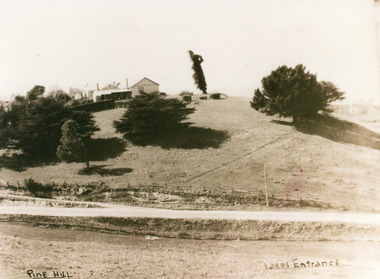
Photograph - Pine Hill Guesthouse Lakes Entrance Victoria c1950
... Pine Hill Guesthouse Lakes Entrance Victoria c1950...Sepia toned photograph of Pine Hill Guesthouse, showing rambling building on top of hill, landmark tree, and pine trees on hillside. ...Pine Hill Lakes Entrance...Guesthouses Roads and Streets Topography Pine Hill Lakes Entrance Sepia toned photograph of Pine Hill Guesthouse, showing rambling building on top of hill, landmark tree, and pine trees on hillside. ...Also second copy which is a very clear photo.Sepia toned photograph of Pine Hill Guesthouse, showing rambling building on top of hill, landmark tree, and pine trees on hillside. Road in foreground is Princes Highway. In far distance a glimpse of Cunninghame Arm. Pine Hill Lakes Entranceguesthouses, roads and streets, topography -
 Greensborough Historical Society
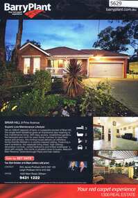
Advertising Leaflet, 9 Pine Avenue Briar Hill, 07/11/2012
... 9 Pine Avenue Briar Hill...pine avenue briar hill...9 Pine Avenue Briar Hill. 3 bedroom home, private sale, sold 7 November 2012 for $515,000...9 Pine Avenue Briar Hill. 3 bedroom home, private sale, sold 7 November 2012 for $515,000 pine avenue briar hill Real estate advertising leaflet, 1 sheet, printed in colour both sides 9 Pine Avenue Briar Hill Advertising Leaflet Barry Plant Eltham ...9 Pine Avenue Briar Hill. 3 bedroom home, private sale, sold 7 November 2012 for $515,000Real estate advertising leaflet, 1 sheet, printed in colour both sidespine avenue briar hill -
 Ballarat Heritage Services
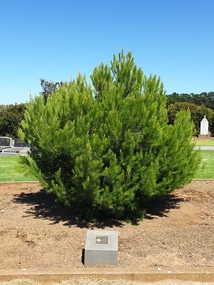
Photograph - Photograph - Colour, Clare Gervasoni, Aleppo Pine, Tower Hill Cemetery, 2019, 03/01/2019
... Aleppo Pine, Tower Hill Cemetery, 2019...pine...anzac centenary...centenary...anniversary...tower hill...Colour photographs of an Aleppo Pine planted in the Tower Hill Cemetery to mark the centenary of the landing at Galipolli....Aleppo Pine, Tower Hill Cemetery, 2019 Photograph Photograph - Colour Clare Gervasoni ...The Tower Hill Cemetery is located near Koroit on the north side of the Princes Highway The, between Port Fairy and Warrnambool. The first burial at Tower Hill Cemetery took place in 1856. Over 150 years there has been over 8,000 burials. Around 45 percent of the burials are in unmarked graves. In 2023 this tree was no longer in existence, and a smaller tree was struggling in this site.Colour photographs of an Aleppo Pine planted in the Tower Hill Cemetery to mark the centenary of the landing at Galipolli.aleppo pine, anzac centenary, centenary, anniversary, tower hill cemetery, gallipoli -
 Lakes Entrance Historical Society
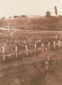
Photograph - Merrangbaur House Lakes Entrance Victoria c1950
... Sepia toned photograph of Pine Hill. Guest house is visible on brow of hill. ...formerly Merrangbaur House, showing the tree which for many years was a Lakes Entrance landmark and a navigation sign for boats entering the original entrance Guesthouses Tourism Topography Sepia toned photograph of Pine Hill. Guest house is visible on brow of hill. ...formerly Merrangbaur House, showing the tree which for many years was a Lakes Entrance landmark and a navigation sign for boats entering the original entranceSepia toned photograph of Pine Hill. Guest house is visible on brow of hill. Lakes Entrance Victoriaguesthouses, tourism, topography -
 Eltham District Historical Society Inc
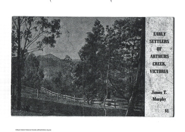
Document - Folder, James T Murphy, Early Settlers of Arthurs Creek, Victoria, 1971
... ...pine hill...arthurs creek harry gilham collection archibald macfarlane ardchattan arthurs creek school brennans charles creighton collins cornelius stewart davey wilson drapers lane duncan smith f. sims hazelglen hazelglen school. alex smith hugh macmillan james millar brock james sutherland james t murphy john bear john macdonald john ryder john smith joseph lobb joseph murphy maloney michael brennan p. green patrick reid pierre brennan pine hill richard bassett rtanks corner spicer thomas murphy william laidlay william murphy Photocopy of original book: Early Settlers of Arthurs Creek, Victoria published in 1971 by James T. ...Photocopy of original book: Early Settlers of Arthurs Creek, Victoria published in 1971 by James T. Murphy with an additon of a map of Shire of Eltham dated 2004.arthurs creek, harry gilham collection, archibald macfarlane, ardchattan, arthurs creek school, brennans, charles creighton, collins, cornelius stewart, davey wilson, drapers lane, duncan smith, f. sims, hazelglen, hazelglen school. alex smith, hugh macmillan, james millar brock, james sutherland, james t murphy, john bear, john macdonald, john ryder, john smith, joseph lobb, joseph murphy, maloney, michael brennan, p. green, patrick reid, pierre brennan, pine hill, richard bassett, rtanks corner, spicer, thomas murphy, william laidlay, william murphy -
 Surrey Hills Historical Society Collection
Folder of real estate advertisements, Folders of real estate advertisements (Streets beginning with P), Various
... pine street...prospect hill road...park road payne street pembroke street pine street prospect hill road proudfroot street A4 folders with individual pockets for each property in streets beginning with P located in Surrey Hills and Mont Albert. ...A4 folders with individual pockets for each property in streets beginning with P located in Surrey Hills and Mont Albert. Folders are ordered by street name and then chronologically by property number. Each property has its own pocket. This may include multiple real estate advertisements collected from sales over time. It may also include copies of any research undertaken by Alan Holt and / or members of the SHNCHC team. These are augmented by cards in the Alan Holt index file and by his property registers of Surrey Hills and Mont Albert.park road, payne street, pembroke street, pine street, prospect hill road, proudfroot street -
 Linton and District Historical Society Inc
Photograph, Lucky Woman's, Bolte Country
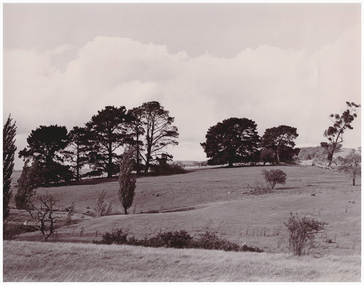
... Two Black and White copies of original photograph showing a landscape with Dreamer's Hill and pine trees in the background and a hill paddock with a creek in the foreground....Two Black and White copies of original photograph showing a landscape with Dreamer's Hill and pine trees in the background and a hill paddock with a creek in the foreground. ...Two Black and White copies of original photograph showing a landscape with Dreamer's Hill and pine trees in the background and a hill paddock with a creek in the foreground."962 Bolte Country- Lucky Womans. The home was approximately where the small white stump stands." "857 Lucky Womans 1982 Bolte Country-".bolte family, lucky woman's -
 Orbost & District Historical Society
black and white photograph, 1994
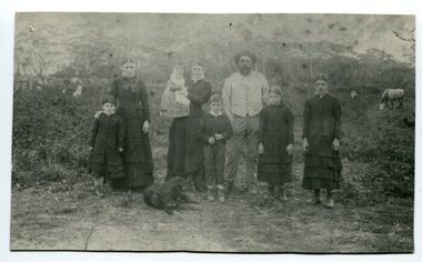
... The house on the hill, now Pine Hill was named Merrangbaur (home of the lyrebird). ...The house on the hill, now Pine Hill was named Merrangbaur (home of the lyrebird). ...The Roadknight family settled on Ewing's Marsh on what is now known as the Old Station In 1850. The Lakes Entrance run was occupied by the late Thomas Roadknight. In 1852 his brother William took charge. Soon after this Corringle Station was occupied by the late T. T. Stirling. William was born at Collingwood, the son of William Roadknight and Jane Stirling. The Roadknight family came from Colac on board the Enterprise to their new home at Cunninghame. The house on the hill, now Pine Hill was named Merrangbaur (home of the lyrebird). William held the Lake Tyers and Snowy River run in partnership with Thomas Telfer Stirling who took up the eastern end of the run on the west bank of the Snowy River. The run included Ewing‟s Marsh — the Ewing brothers were earlier landowners but had no formal run in this area. William served four terms on the Tambo Shire Council as a representative of the Bendoc Riding despite not being a resident of the Riding. He was then elected to the Orbost Shire as a West Riding councillor in 1896-97, 1897-98 and was Shire President in his final year 1898-99 This item is associated with Roadknight family who were early settlers in the Orbost district.A black / white photograph of a family group of mother, father and six children standing outdoor. There is a dog lying in front .roadknight-william ewing's-marsh old-station-orbost -
 Phillip Island and District Historical Society Inc.
Photograph, 1950
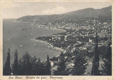
... Aerial view of San Remo coastline with row of various Pine Trees across foreground. Hills in background. Pier at top left. ...Personal communication from Europe to relative (Aunt Elsie) in San Remo dated 17/06/1951 photography photographs aerial view - coastal view - san remo europe black & white photograph comparison views san remo aerial San Remo - Riviera Dei Fiori - Panorama Aerial view of San Remo coastline with row of various Pine Trees across foreground. Hills in background. Pier at top left. ...Personal communication from Europe to relative (Aunt Elsie) in San Remo dated 17/06/1951Aerial view of San Remo coastline with row of various Pine Trees across foreground. Hills in background. Pier at top left. Shows town area of San Remo in Italy, Europe.San Remo - Riviera Dei Fiori - Panoramaphotography, photographs, aerial view - coastal view - san remo europe, black & white photograph, comparison views san remo, aerial -
 The Beechworth Burke Museum
Photograph, Unknown
... Visible are a few miners, sheds, cliffs at rear and the road into town (Pine Hill). Water races are also visible, which is notable to the areas unique use of hydraulic sluicing as a mining method. ...Visible are a few miners, sheds, cliffs at rear and the road into town (Pine Hill). Water races are also visible, which is notable to the areas unique use of hydraulic sluicing as a mining method. ...This photograph depicts the excavated area of alluvial gold mining locations One Mile Diggings and Pennyweight Flat near the Spring Creek precinct, Beechworth, significant locations of the 1850's Gold Rush which built Beechworth into a prosperous, regional town centre. Visible are a few miners, sheds, cliffs at rear and the road into town (Pine Hill). Water races are also visible, which is notable to the areas unique use of hydraulic sluicing as a mining method. Beechworth sluicer Donald Fletcher, a key figure of the town’s colonial history, first claim was a sluicing operation at Pennyweight Flat. Here, he completed build on a tail-race in 1871 nearly as long as that of the Rocky Mountain Company, who held significant holdings within the area. In 1859, the site and its surrounding areas were estimated to have a predominant European and Chinese population. In 1883 it was reported that 'thousands of tents' were pitched in the area. After all surface gold was exhausted, miners began to bore quartz until operations waned toward the turn of the century. In 1928 the mine was converted to what is today known as Lake Sambell. This photograph is historically significant as it provides insight into the landscape, working conditions and mining methods used for alluvial mining during the Beechworth Gold Rush.Sepia rectangular photograph printed on matte photographic paper unmounted.Reverse: 84.222.1 / page 41 62% (crossed out) / [ineligible] / One mile diggings where the large bank is view towards Pennyweight flat / [ineligible] 13one mile diggings, pennyweight flat, beechworth mining district, lake sambell, donald fletcher, hydraulic sluicing -
 The Beechworth Burke Museum
Photograph
... Visible are a few miners, sheds, cliffs at rear and the road into town (Pine Hill). Water races are also visible, which is notable to the areas unique use of hydraulic sluicing as a mining method. ...Visible are a few miners, sheds, cliffs at rear and the road into town (Pine Hill). Water races are also visible, which is notable to the areas unique use of hydraulic sluicing as a mining method. ...This photographic copy depicts the excavated area of alluvial gold mining locations One Mile Diggings and Pennyweight Flat near the Spring Creek precinct, Beechworth, significant locations of the 1850's Gold Rush which built Beechworth into a prosperous, regional town centre. Visible are a few miners, sheds, cliffs at rear and the road into town (Pine Hill). Water races are also visible, which is notable to the areas unique use of hydraulic sluicing as a mining method. Beechworth sluicer Donald Fletcher, a key figure of the town’s colonial history, first claim was a sluicing operation at Pennyweight Flat. Here, he completed build on a tail-race in 1871 nearly as long as that of the Rocky Mountain Company, who held significant holdings within the area. In 1859, the site and its surrounding areas were estimated to have a predominant European and Chinese population. In 1883 it was reported that 'thousands of tents' were pitched in the area. After all surface gold was exhausted, miners began to bore quartz until operations waned toward the turn of the century. In 1928 the mine was converted to what is today known as Lake Sambell. This photograph is historically significant as it provides insight into the landscape, working conditions and mining methods used for alluvial mining during the Beechworth Gold Rush.Black and white rectangular photograph printed on matte photographic paper unmounted.Reverse: 844.222.3 / Pennyweight flat goldfieldsone mile diggings, pennyweight flat, beechworth mining district, lake sambell, donald fletcher, hydraulic sluicing -
 Kiewa Valley Historical Society
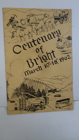
Booklet - Bright, Centenary of Bright March 10th - 18th, 1962
... One sketch is at the bottom and includes hills, pines, saw mill and bus. Sketch at the top is of a bullock team and in the middle on the right a gold miner. ...One sketch is at the bottom and includes hills, pines, saw mill and bus. Sketch at the top is of a bullock team and in the middle on the right a gold miner. ...Township of Bright celebrated its centenary during the week from 10th - 18th March, 1962. This booklet outlines the program for the week.Bright is a nearby town to the the Kiewa Valley and currently the location of the current Shire (Alpine). The program gives historical information on activities in the early 1960s.Yellowy/Orange cover with brown title and sketch. One sketch is at the bottom and includes hills, pines, saw mill and bus. Sketch at the top is of a bullock team and in the middle on the right a gold miner. Inside cover has print as has both sides of the 4 pages held by 2 staples. 'C. Roper' on inside of the front cover.bright, centenary of bright -
 Ringwood and District Historical Society
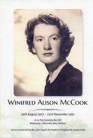
Programme, Order of Service for Funeral for Winifred Alison McCook, long standing Ringwood solicitor - 24th August 1923 - 23rd November 2015
... Service conducted at Le Pine Funerals, Box Hill on Wednesday 2 December, 2015....Service conducted at Le Pine Funerals, Box Hill on Wednesday 2 December, 2015. ...Bifold Card featuring three photographs of Ms McCook, words of "Abide with me" by Henry F. Lyte, biblical readings and religious referrals. The card mentions eulogies by Margaret Fankhauser, Anne Hartnett, Julie Turner, and prayer by Rev. John Huynh. Service conducted at Le Pine Funerals, Box Hill on Wednesday 2 December, 2015. -
 Lara RSL Sub Branch
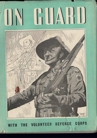
Book, On Guard with the Volunteer Defence Corps
... Krithia, Quinn's Post Lone Pine, The Nek, Hill 971, SAri Bair, Chunuk Bair, Hill 60, Fromelles, Ypres, Messines, Menin Road, Broodseinde, Polygon Wood, Paschendalle, Strazeele, Pozieres, Moquet Farm, Bullecourt, Villes Bret, Hamel, Mont St. ...Krithia, Quinn's Post Lone Pine, The Nek, Hill 971, SAri Bair, Chunuk Bair, Hill 60, Fromelles, Ypres, Messines, Menin Road, Broodseinde, Polygon Wood, Paschendalle, Strazeele, Pozieres, Moquet Farm, Bullecourt, Villes Bret, Hamel, Mont St. ...Krithia, Quinn's Post Lone Pine, The Nek, Hill 971, SAri Bair, Chunuk Bair, Hill 60, Fromelles, Ypres, Messines, Menin Road, Broodseinde, Polygon Wood, Paschendalle, Strazeele, Pozieres, Moquet Farm, Bullecourt, Villes Bret, Hamel, Mont St. Quintin, Peronne, Hindenburg Line, Romani, Magdhaba, Rafa, Gaza, Beersheba, Jerusalem, Jericho, Es Salt, Amman, Megiddo, Sharon, Damascus.2 x On Guard with the Volunteer Defence Corpsvolunteer defence force in wwii, europe -
 Bendigo Historical Society Inc.
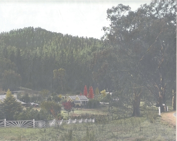
Photograph - HOUSE IN LANDSCAPE VIEW, 1960's ?
... House is small cottage, set in front of pine forest rising on hill to rear. Large eucalypts on right with road just evident on extreme right of photo....House is small cottage, set in front of pine forest rising on hill to rear. Large eucalypts on right with road just evident on extreme right of photo. ...Hand tinted photo: photo of house in rural setting with autumn toned trees. Photo appears to have been taken at Daylesford or Hepburn Springs. House is small cottage, set in front of pine forest rising on hill to rear. Large eucalypts on right with road just evident on extreme right of photo.F. T. Kennedyplace, building, rural cottage -
 Warrnambool and District Historical Society Inc.
Map - Maps, Soldiers Settlement WW2, Circa 1950
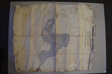
... The maps are as follows: .1 Narrapumelap Estate ( Ripon & Hampden) .2 Narrapumelap Estate Part 2 (Villers & Ripon) .3 Narrapumelap Estate Part 3 ( Villiers & Ripon) .4 Burrumbeet Estate ( Ripon) .5 ' Berrambool' Estate 9 Hampden & Villiers) .6 ' Hopkins Hill' Estate Villiers 4011 acres .7 Caramut North No 2 Estate ( Villiers ) .8 ' Morpor' Estate ( Villiers) 4172 acres .9 ' Morgiana' Estate ( Normandy) 3453 acres .10 ' Chatsworth House' ( Villiers) 9341 Acres .11 ' East Elwood' Estate Villiers 2407 acres .12 Grey's Estate ( Mornington) 1151acres .13 ' Rowes Estate' ( Buln Buln Gippsland 733 acres .14 'Tarrone' Estate No 2 Part map .15 'Chaldon Meade' Estate (Bourke) Bulla 517 acres .16 ' Terranallum South' Estate Hampden 3757 acres .17 ' Brung Brungle' Estate Dundas 695 .18 ' Armidale ' Estate ( Dundas)2108 acres .19 ' Moyne Falls' Estate ( Villiers) 627 acres .20' Yulong' Estate 9 Lowan 6321 acres .21 Murray Valley Irrigation District 9 Moira)113 acres .22 Murray Valley Irrigation District 103 acres .23 ' Mount Fyans' Estate ( Hampden) .24 ' Barwidgee ' Estate ( Villiers) 4277 acres .25 'Pine Hills' Estate 2nd portion ( Lowan) 6190 acres ...As such they have historic and social interest and significance. narrapumelap berrambool hopkins hill caramut north morpor chatsworth house east elwood terrinallum moyne falls tarrone caramut soldiers settlers Burrumbeet morgiana grey's estate mornington chaldon meade brung brungle The maps are as follows: .1 Narrapumelap Estate ( Ripon & Hampden) .2 Narrapumelap Estate Part 2 (Villers & Ripon) .3 Narrapumelap Estate Part 3 ( Villiers & Ripon) .4 Burrumbeet Estate ( Ripon) .5 ' Berrambool' Estate 9 Hampden & Villiers) .6 ' Hopkins Hill' Estate Villiers 4011 acres .7 Caramut North No 2 Estate ( Villiers ) .8 ' Morpor' Estate ( Villiers) 4172 acres .9 ' Morgiana' Estate ( Normandy) 3453 acres .10 ' Chatsworth House' ( Villiers) 9341 Acres .11 ' East Elwood' Estate Villiers 2407 acres .12 Grey's Estate ( Mornington) 1151acres .13 ' Rowes Estate' ( Buln Buln Gippsland 733 acres .14 'Tarrone' Estate No 2 Part map .15 'Chaldon Meade' Estate (Bourke) Bulla 517 acres .16 ' Terranallum South' Estate Hampden 3757 acres .17 ' Brung Brungle' Estate Dundas 695 .18 ' Armidale ' Estate ( Dundas)2108 acres .19 ' Moyne Falls' Estate ( Villiers) 627 acres .20' Yulong' Estate 9 Lowan 6321 acres .21 Murray Valley Irrigation District 9 Moira)113 acres .22 Murray Valley Irrigation District 103 acres .23 ' Mount Fyans' Estate ( Hampden) .24 ' Barwidgee ' Estate ( Villiers) 4277 acres .25 'Pine Hills' Estate 2nd portion ( Lowan) 6190 acres A collection of 25 paper maps which relate to to the soldiers settlement post World War 2. ...The soldiers' settlement scheme operated after the first and second world wars in an effort to more closely settle the land and also give opportunities to returned soldiers. Crown land and other larger estates were acquired for the purpose. Most of these maps relate to the area north of Warrnambool where many of the subdivisions were parts of larger estates.These maps pertaining to the Soldiers' Settlement program, relate to an interesting part of Australian and local history. As such they have historic and social interest and significance.A collection of 25 paper maps which relate to to the soldiers settlement post World War 2. Some have details of the people allocated the land and some smaller maps have the printed details of the applicants requirements.Text is black on white paper which in some cases is quite aged. The maps are as follows: .1 Narrapumelap Estate ( Ripon & Hampden) .2 Narrapumelap Estate Part 2 (Villers & Ripon) .3 Narrapumelap Estate Part 3 ( Villiers & Ripon) .4 Burrumbeet Estate ( Ripon) .5 ' Berrambool' Estate 9 Hampden & Villiers) .6 ' Hopkins Hill' Estate Villiers 4011 acres .7 Caramut North No 2 Estate ( Villiers ) .8 ' Morpor' Estate ( Villiers) 4172 acres .9 ' Morgiana' Estate ( Normandy) 3453 acres .10 ' Chatsworth House' ( Villiers) 9341 Acres .11 ' East Elwood' Estate Villiers 2407 acres .12 Grey's Estate ( Mornington) 1151acres .13 ' Rowes Estate' ( Buln Buln Gippsland 733 acres .14 'Tarrone' Estate No 2 Part map .15 'Chaldon Meade' Estate (Bourke) Bulla 517 acres .16 ' Terranallum South' Estate Hampden 3757 acres .17 ' Brung Brungle' Estate Dundas 695 .18 ' Armidale ' Estate ( Dundas)2108 acres .19 ' Moyne Falls' Estate ( Villiers) 627 acres .20' Yulong' Estate 9 Lowan 6321 acres .21 Murray Valley Irrigation District 9 Moira)113 acres .22 Murray Valley Irrigation District 103 acres .23 ' Mount Fyans' Estate ( Hampden) .24 ' Barwidgee ' Estate ( Villiers) 4277 acres .25 'Pine Hills' Estate 2nd portion ( Lowan) 6190 acres narrapumelap, berrambool, hopkins hill, caramut north, morpor, chatsworth house, east elwood, terrinallum, moyne falls, tarrone, caramut soldiers settlers, burrumbeet, morgiana, grey's estate mornington, chaldon meade, brung brungle -
 Melbourne Tram Museum
Ephemera - Timetable - bus - The Met - set of 24, The Met, 1992 & 1993
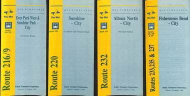
... All dated during1993 unless noted otherwise. 1 - Route 216/9 - Deer Park West & Sunshine Park - City 2 - Route 220 - Sunshine - City - 1992 3 - Route 232 - Altona North - City - 1992 4 - Route 233 - Fishermens Bend - City - 1992 5 - Route 254 - Northland Shopping Centre - City - 1992 6 - Route 256 - La Trobe Uni - City - 1992 7 - Routes 258 & 259 - Northland Shopping Centre, and La Trobe Uni - City via Eastern Freeway - 1992 8 - Route 260 etc - Deep Creek Templestow - Donvale - City 9 - Route 264 - Mitcham, Donvale City 10 - Route 265 - Deep Creek - City 11 - Route 602 - Brighton - city 12 - Route 269, 291 and 296 - Greensborough, Heidelberg & Newmans Road to Box Hill 13 - Route 272 - Warrandyte - City 14 - Route 276 & 278 - Warrandyte - City 15 - Route 284 & 270 - East Kew - City or Box Hill 16 - Route 285 - The Pines - Box Hill 17 - Route 286 & 288 - The Pines and Templestowe - Box Hill 18 - Route 290 - North Nunawading - Box Hill 19 - Route 292 etc - Box Hill, Deep Creek, Ringwood, Warrandyte 20 - Route 301, 281 315 - Ringwood, Park Orchards and Donvale - City 21 - Route 305 - Box Hill - Ringwood 22 - Route 366 & 367 - Ringwood - Croydon 23 - Route 600 - St Kilda - Brighton Beach - 1992 24 - Route 601 - Gardenvale - City - 1992...All dated during1993 unless noted otherwise. 1 - Route 216/9 - Deer Park West & Sunshine Park - City 2 - Route 220 - Sunshine - City - 1992 3 - Route 232 - Altona North - City - 1992 4 - Route 233 - Fishermens Bend - City - 1992 5 - Route 254 - Northland Shopping Centre - City - 1992 6 - Route 256 - La Trobe Uni - City - 1992 7 - Routes 258 & 259 - Northland Shopping Centre, and La Trobe Uni - City via Eastern Freeway - 1992 8 - Route 260 etc - Deep Creek Templestow - Donvale - City 9 - Route 264 - Mitcham, Donvale City 10 - Route 265 - Deep Creek - City 11 - Route 602 - Brighton - city 12 - Route 269, 291 and 296 - Greensborough, Heidelberg & Newmans Road to Box Hill 13 - Route 272 - Warrandyte - City 14 - Route 276 & 278 - Warrandyte - City 15 - Route 284 & 270 - East Kew - City or Box Hill 16 - Route 285 - The Pines - Box Hill 17 - Route 286 & 288 - The Pines and Templestowe - Box Hill 18 - Route 290 - North Nunawading - Box Hill 19 - Route 292 etc - Box Hill, Deep Creek, Ringwood, Warrandyte 20 - Route 301, 281 315 - Ringwood, Park Orchards and Donvale - City 21 - Route 305 - Box Hill - Ringwood 22 - Route 366 & 367 - Ringwood - Croydon 23 - Route 600 - St Kilda - Brighton Beach - 1992 24 - Route 601 - Gardenvale - City - 1992 Yields information about some of The Met bus services 1993 timetables The Met route 216 route 220 route 232 route 233 Route 254 route 258 Route 259 route 260 route 264 route 265 route 256 Route 602 route 269 Route 272 route 276 route 284 route 270 route 285 route 286 route 288 Route 290 route 292 route 301 route 305 route 366 route 367 route 600 route 601 Set of 24 The Met timetables, DL size, printed in two colours. ...SSet of 24 The Met bus timetables, with diagrammatic map, major stops and contact details. All dated during1993 unless noted otherwise. 1 - Route 216/9 - Deer Park West & Sunshine Park - City 2 - Route 220 - Sunshine - City - 1992 3 - Route 232 - Altona North - City - 1992 4 - Route 233 - Fishermens Bend - City - 1992 5 - Route 254 - Northland Shopping Centre - City - 1992 6 - Route 256 - La Trobe Uni - City - 1992 7 - Routes 258 & 259 - Northland Shopping Centre, and La Trobe Uni - City via Eastern Freeway - 1992 8 - Route 260 etc - Deep Creek Templestow - Donvale - City 9 - Route 264 - Mitcham, Donvale City 10 - Route 265 - Deep Creek - City 11 - Route 602 - Brighton - city 12 - Route 269, 291 and 296 - Greensborough, Heidelberg & Newmans Road to Box Hill 13 - Route 272 - Warrandyte - City 14 - Route 276 & 278 - Warrandyte - City 15 - Route 284 & 270 - East Kew - City or Box Hill 16 - Route 285 - The Pines - Box Hill 17 - Route 286 & 288 - The Pines and Templestowe - Box Hill 18 - Route 290 - North Nunawading - Box Hill 19 - Route 292 etc - Box Hill, Deep Creek, Ringwood, Warrandyte 20 - Route 301, 281 315 - Ringwood, Park Orchards and Donvale - City 21 - Route 305 - Box Hill - Ringwood 22 - Route 366 & 367 - Ringwood - Croydon 23 - Route 600 - St Kilda - Brighton Beach - 1992 24 - Route 601 - Gardenvale - City - 1992Yields information about some of The Met bus services 1993Set of 24 The Met timetables, DL size, printed in two colours.timetables, the met, route 216, route 220, route 232, route 233, route 254, route 258, route 259, route 260, route 264, route 265, route 256, route 602, route 269, route 272, route 276, route 284, route 270, route 285, route 286, route 288, route 290, route 292, route 301, route 305, route 366, route 367, route 600, route 601 -
 Eltham District Historical Society Inc
Negative - Photograph, Unveiling of War Memorial Obelisk, corner of Main Road and Bridge Street, Eltham
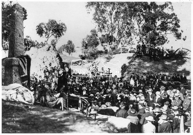
... "Beneath a lonely pine tree on the hill crest out from Eltham, where the Greensborough Road junctions with the main Melbourne Road, Eltham has erected an everlasting tribute to the memory of the fallen heroes of the district. ..."Beneath a lonely pine tree on the hill crest out from Eltham, where the Greensborough Road junctions with the main Melbourne Road, Eltham has erected an everlasting tribute to the memory of the fallen heroes of the district. ...The unveiling of the Eltham Obelisk War Memorial was performed by the Rev. Padre Charles Tregear, assisted by Church of England vicar, Mr Safsford on August 3, 1919. Reproduced page 99 of "Pioneers & Painters." "Beneath a lonely pine tree on the hill crest out from Eltham, where the Greensborough Road junctions with the main Melbourne Road, Eltham has erected an everlasting tribute to the memory of the fallen heroes of the district. It is an obelisk of Harcourt granite in the rough, bearing an appropriate inscription and 27 names—an unpretentious monument by the wayside, which will stand for all time silently expressing the appreciation of the living for the sacrifice of the dead. The obelisk stands 14 feet high. ... Representatives of every house in the town, and many people from the surrounding district, gathered around the obelisk for the opening ceremony. The spring-like sunshine of the afternoon attracted everybody out of doors. There must have been 700 people present when the Lieutenant-Governor, Sir William Irvine, removed the draping of flags and revealed the names on the obelisk, the base of which was surrounded by wreaths and branches of wattle bloom, placed there by parents whose sorrow at the loss of sons was blunted, for the day at least, by feelings of pride. .." Age, Monday 4 August 1919, page 8 This was the memorial's orginal location. It has been relocated numerous times.This photo forms part of a collection of photographs gathered by the Shire of Eltham for their centenary project book,"Pioneers and Painters: 100 years of the Shire of Eltham" by Alan Marshall (1971). The collection of over 500 images is held in partnership between Eltham District Historical Society and Yarra Plenty Regional Library (Eltham Library) and is now formally known as the 'The Shire of Eltham Pioneers Photograph Collection.' It is significant in being the first community sourced collection representing the places and people of the Shire's first one hundred years.Digital image 4 x 5 inch B&W Negsepp, shire of eltham pioneers photograph collection, eltham, main road, bridge street, eltham war memorial, obelisk, obelisk corner -
 Eltham District Historical Society Inc
Negative - Photograph, Unveiling of War Memorial Obelisk, corner of Main Road and Bridge Street, Eltham, 3 Aug. 1919
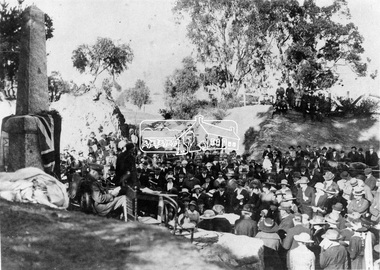
... "Beneath a lonely pine tree on the hill crest out from Eltham, where the Greensborough Road junctions with the main Melbourne Road, Eltham has erected an everlasting tribute to the memory of the fallen heroes of the district. ..."Beneath a lonely pine tree on the hill crest out from Eltham, where the Greensborough Road junctions with the main Melbourne Road, Eltham has erected an everlasting tribute to the memory of the fallen heroes of the district. ...The unveiling of the Eltham Obelisk War Memorial was performed by the Rev. Padre Charles Tregear, assisted by Church of England vicar, Mr Safsford on August 3, 1919. Reproduced page 99 of "Pioneers & Painters." "Beneath a lonely pine tree on the hill crest out from Eltham, where the Greensborough Road junctions with the main Melbourne Road, Eltham has erected an everlasting tribute to the memory of the fallen heroes of the district. It is an obelisk of Harcourt granite in the rough, bearing an appropriate inscription and 27 names—an unpretentious monument by the wayside, which will stand for all time silently expressing the appreciation of the living for the sacrifice of the dead. The obelisk stands 14 feet high. ... Representatives of every house in the town, and many people from the surrounding district, gathered around the obelisk for the opening ceremony. The spring-like sunshine of the afternoon attracted everybody out of doors. There must have been 700 people present when the Lieutenant-Governor, Sir William Irvine, removed the draping of flags and revealed the names on the obelisk, the base of which was surrounded by wreaths and branches of wattle bloom, placed there by parents whose sorrow at the loss of sons was blunted, for the day at least, by feelings of pride. .." Age, Monday 4 August 1919, page 8 This was the memorial's orginal location. It has been relocated numerous times.This photo forms part of a collection of photographs gathered by the Shire of Eltham for their centenary project book,"Pioneers and Painters: 100 years of the Shire of Eltham" by Alan Marshall (1971). The collection of over 500 images is held in partnership between Eltham District Historical Society and Yarra Plenty Regional Library (Eltham Library) and is now formally known as the 'The Shire of Eltham Pioneers Photograph Collection.' It is significant in being the first community sourced collection representing the places and people of the Shire's first one hundred years.Digital image 4 x 5 inch B&W Neg Print 9 x 12.5cmsepp, shire of eltham pioneers photograph collection, eltham, main road, eltham war memorial, bridge street, obelisk, obelisk corner -
 Flagstaff Hill Maritime Museum and Village
Furniture - Book Rest, circa 1930
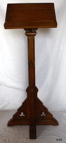
... The connection of this item to the Mission to Seamen and to the Ladies Lightkeepers’ Auxiliary highlights the strong community awareness of the life of people at sea, their dangers and hardships, and their need for physical, financial, spiritual and moral support. religious service missions to seamen victoria church furniture religious worship lectern book rest bible rest preaching accessory Flagstaff Hill Warrnambool Shipwrecked coast Flagstaff Hill Maritime Museum Maritime Museum Shipwreck coast Flagstaff Hill Maritime Village Great Ocean Road Religion Sailors Rest Bethel Sailors’ Church Bethel Floating Church Ladies Harbour Light Guild Harbor Lights Guild Joy Club for Fighters Ladies Lightkeepers’ Auxiliary Mission to Seafarers Flying Angel’s Club St Nicholas Seamen’s Church Williamstown St Nicholas Mission to Seamen Church Williamstown Mission to Seamen Williamstown St Nicholas Seamen’s Church Flagstaff Hill 139 Nelson Place Williamstown Religious furniture Anglican Church altar book rest Book rest, or lectern: This is a traditional book rest made of kauri pine with column support. ...This altar book rest, also called a lectern, was part of the original furnishings of the St Nicholas' Mission to Seamen's Church at 139 Nelson Place, Williamstown, Victoria, operated by the Mission to Seamen organisation. THE MISSIONS TO SEAMEN (Brief History): - The Missions to Seamen was an Anglican charity in Great Britain that has served the world's seafarers since 1856. Its symbol is a Flying Angel, inspired by a Bible verse. Today, there are centres in over 200 ports worldwide where seamen of all backgrounds are offered a warm welcome and provided with a wide range of facilities. In Victoria, the organisation began in Williamstown in 1857 as a Sailors’ Church, also known as ‘Bethel’ or the ‘Floating Church’ in an old hulk floating in Hobson’s Bay, Port of Melbourne. It soon became part of the Missions to Seamen, Victoria. In 2000, the organisation, now named Mission to Seafarers, still operated locally in Melbourne, Portland, Geelong and Hastings. The Ladies’ Harbour Lights Guild was formed in 1906 to support the Missions to Seamen in Melbourne and other centres, such as Williamstown. Two of the most significant ladies of the Guild were founder Ethel Augusta Godfrey and foundation member Alice Sibthorpe Tracy (who established a branch of the Guild in Warrnambool in 1920). The Guild continued its work until the 1960s. In 1943, a former Williamstown bank was purchased for the Missions to Seamen Club. The chapel was named St Nicholas’ Seamen’s Church and was supported by the Ladies’ Harbour Lights Guild, the Williamstown Lightkeepers’ Auxiliary and the League of Soldiers’ and Sailors’ Friends. It ceased operation in 1966. A Missions to Seamen Chapel and Recreation Room was a significant feature of ports during the late 1800s and 1900s. It seemed appropriate for Flagstaff Hill to include such a representation within the new Maritime Village, and the Melbourne Board of Management of Missions to Seamen Victoria gave its permission on 21st May 1979 for the entire furnishings of the Williamstown chapel to be transferred to Flagstaff Hill. The St Nicholas Seamen’s Church was officially opened on October 11, 1981, and resembles the Williamstown chapel. This altar book rest is significant historically for its origin in the St Nicholas Mission to Seamen's Church in Williamstown, established in 1857 to cater for the physical, social, and spiritual needs of seafarers. It originated in Bristol, England when a Seamen's Mission was formed in 1837. The lectern is historically significant for its connection to the Ladies Lightkeepers’ Auxiliary, an organisation of women, formed to support seafarers. The connection of this item to the Mission to Seamen and to the Ladies Lightkeepers’ Auxiliary highlights the strong community awareness of the life of people at sea, their dangers and hardships, and their need for physical, financial, spiritual and moral support. Book rest, or lectern: This is a traditional book rest made of kauri pine with column support. The top section, designed to support a Bible, has an angled backrest and shelf. The item has some decorative cutaway relief. This book restis part of the St. Nicholas Seamen's Church Collection. religious service, missions to seamen victoria, church furniture, religious worship, lectern, book rest, bible rest, preaching accessory, flagstaff hill, warrnambool, shipwrecked coast, flagstaff hill maritime museum, maritime museum, shipwreck coast, flagstaff hill maritime village, great ocean road, religion, sailors rest, bethel sailors’ church, bethel floating church, ladies harbour light guild, harbor lights guild, joy club for fighters, ladies lightkeepers’ auxiliary, mission to seafarers, flying angel’s club, st nicholas seamen’s church williamstown, st nicholas mission to seamen church williamstown, mission to seamen williamstown, st nicholas seamen’s church flagstaff hill, 139 nelson place williamstown, religious furniture, anglican church, altar book rest -
 Flagstaff Hill Maritime Museum and Village
Print - Religious Print, The Last Supper, circa 1890
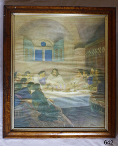
... Flagstaff Hill Maritime Museum and Village Flagstaff Hill Warrnambool Maritime Museum Maritime Village Shipwreck Coast Great Ocean Road Religion Religious service St Nicholas Seamen’s Church Williamstown Missions to Seamen Victoria last supper worship religious worship Ladies Lightkeepers’ Auxiliary Williamstown Lightkeepers' Auxiliary The Last Supper Mission to Seafarers St Nicholas Missions to Seamen’s Church Williamstown Missions to Seamen St Nicholas Missions to Seamen’s Church Flagstaff Hill 139 Nelson Place Williamstown Anglican church worship service church furnishings religious furnishings wall hanging framed print religious print On rear of board: "156" Print of a watercolour painting, framed in Huon pine wood behind glass.Depicts the artist's impression of the Biblical event referred to as The Last Supper. ...This framed print is one of the items once used during religious services at the St. Nicholas Seamen’s Church and was donated to the organisation by the Williamstown Lightkeepers' Auxiliary. The church was located at 139 Nelson Place, Williamstown, Victoria, and operated by the Mission to Seamen organisation. THE MISSIONS TO SEAMEN (Brief History): - The Missions to Seamen was an Anglican charity in Great Britain that has served the world's seafarers since 1856. Its symbol is a Flying Angel, inspired by a Bible verse. Today, there are centres in over 200 ports worldwide where seamen of all backgrounds are offered a warm welcome and provided with a wide range of facilities. In Victoria, the organisation began in Williamstown in 1857 as a Sailors’ Church, also known as ‘Bethel’ or the ‘Floating Church’ in an old hulk floating in Hobson’s Bay, Port of Melbourne. It soon became part of the Missions to Seamen, Victoria. In 2000, the organisation, now named Mission to Seafarers, still operated locally in Melbourne, Portland, Geelong and Hastings. The Ladies’ Harbour Lights Guild was formed in 1906 to support the Missions to Seamen in Melbourne and other centres, such as Williamstown. Two of the most significant ladies of the Guild were founder Ethel Augusta Godfrey and foundation member Alice Sibthorpe Tracy (who established a branch of the Guild in Warrnambool in 1920). The Guild continued its work until the 1960s. In 1943, a former Williamstown bank was purchased for the Missions to Seamen Club. The chapel was named St Nicholas’ Seamen’s Church and was supported by the Ladies’ Harbour Lights Guild, the Williamstown Lightkeepers’ Auxiliary and the League of Soldiers’ and Sailors’ Friends. It ceased operation in 1966. A Missions to Seamen Chapel and Recreation Room was a significant feature of ports during the late 1800s and 1900s. It seemed appropriate for Flagstaff Hill to include such a representation within the new Maritime Village, and the Melbourne Board of Management of Missions to Seamen Victoria gave its permission on 21st May 1979 for the entire furnishings of the Williamstown chapel to be transferred to Flagstaff Hill. The St Nicholas Seamen’s Church was officially opened on October 11, 1981, and resembles the Williamstown chapel.This print is significant historically for its origin in the St Nicholas Mission to Seamen's Church in Williamstown, established in 1857 to cater for the physical, social, and spiritual needs of seafarers. It originated in Bristol, England when a Seamen's Mission was formed in 1837. The item is historically significant for its connection to the Williamstown Lightkeepers’ Auxiliary, an organisation of women, formed to support seafarers. The connection of this item to the Mission to Seamen and the Ladies Lightkeepers’ Auxiliary highlights the strong community awareness of the life of people at sea, their dangers and hardships, and their need for physical, financial, spiritual and moral support. Print of a watercolour painting, framed in Huon pine wood behind glass.Depicts the artist's impression of the Biblical event referred to as The Last Supper. Inscription marked on the back. Australian, circa 1890. The print is part of the St Nicholas Seamen's Church Collection On rear of board: "156" flagstaff hill maritime museum and village, flagstaff hill, warrnambool, maritime museum, maritime village, shipwreck coast, great ocean road, religion, religious service, st nicholas seamen’s church, williamstown, missions to seamen victoria, last supper, worship, religious worship, ladies lightkeepers’ auxiliary, williamstown lightkeepers' auxiliary, the last supper, mission to seafarers, st nicholas missions to seamen’s church williamstown, missions to seamen, st nicholas missions to seamen’s church flagstaff hill, 139 nelson place williamstown, anglican church, worship service, church furnishings, religious furnishings, wall hanging, framed print, religious print -
 Flagstaff Hill Maritime Museum and Village
Instrument - Foghorn, Late 19th century
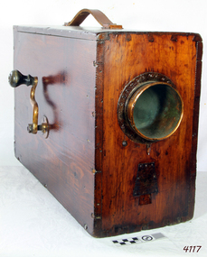
... Therefore the item has a historical connection with sailing and maritime pursuits from our past. flagstaff hill warrnambool shipwrecked coast flagstaff hill maritime museum maritime museum shipwreck coast flagstaff hill maritime village great ocean road foghorn maritime technology maritime communication marine warning signal portable foghorn bellows foghorn crank handle Robert Hope-Jones John Northey None English Rotary Norwegian Pattern nautical foghorn within a boxed pine varnished case with exposed corner dovetailing, original leather carrying strap, brass side crank, and original copper trumped horn. ...A foghorn is a device that uses sound to warn of navigational hazards like rocky coastlines, or boats of the presence of other vessels, in foggy conditions. The term is most often used with marine transport. When visual navigation aids such as lighthouses are obscured, foghorns provide an audible warning of rocky outcrops, shoals, headlands, or other dangers to shipping. An early form of fog signal was to use a bell, gong, explosive signal or firing a cannon to alert shipping. From the early 20th century an improved device called the diaphone was used in place of these other devices, The diaphone horn was based directly on the organ stop of the same name invented by Robert Hope-Jones, creator of the Wurlitzer organ. Hope-Jones' design was based on a piston that was closed only at its bottom end and had slots, perpendicular to its axis, cut through its sides, the slotted piston moved within a similarly slotted cylinder. Outside of the cylinder was a reservoir of high-pressure air. Initially, this air would be admitted behind the piston, pushing it forward. When the slots of the piston aligned with those of the cylinder, air passed into the piston, making a sound and pushing the piston back to its starting position, whence the cycle would be repeated. This method of producing a low audible sound was further developed as a fog signal by John Northey of Toronto and these diaphones were powered by compressed air produced by an electric motor or other mechanical means that admitted extremely powerful low-frequency notes. The example in the Flagstaff collection is an early cased and portable diaphone used on pleasure or sailing craft. By manually turning the crank handle air is produced and fed into valves that direct air across vibrating metal reeds to produce the required sound. in foggy weather, fog horns are used to pinpoint a vessels position and to indicate how the vessel is sailing in foggy conditions. One blast, when sailing on starboard tack and two blasts, when sailing on a port tack and three dots, when with wind is behind the vessel. Since the automation of lighthouses became common in the 1960s and 1970s, most older foghorn marine installations have been removed to avoid the need to run the complex machinery associated with them, and have been replaced with an electrically powered diaphragm or compressed air horns. The example in the collection is significant as it was used in the early 19th century for sailing vessels was important but these portable crank fog horns have also been superseded by modern electric varieties. Therefore the item has a historical connection with sailing and maritime pursuits from our past.English Rotary Norwegian Pattern nautical foghorn within a boxed pine varnished case with exposed corner dovetailing, original leather carrying strap, brass side crank, and original copper trumped horn. Card accessory with Directions for Use in both English and French.Noneflagstaff hill, warrnambool, shipwrecked coast, flagstaff hill maritime museum, maritime museum, shipwreck coast, flagstaff hill maritime village, great ocean road, foghorn, maritime technology, maritime communication, marine warning signal, portable foghorn, bellows foghorn, crank handle, robert hope-jones, john northey -
 Flagstaff Hill Maritime Museum and Village
Desk
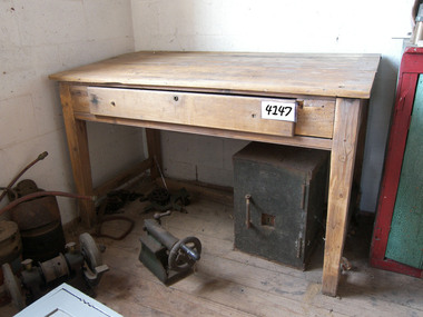
... flagstaff hill warrnambool shipwrecked-coast flagstaff-hill flagstaff-hill-maritime-museum maritime-museum shipwreck-coast flagstaff-hill-maritime-village Desk wooden Baltic pine with slight slope on top, one centre drawer with keylock, plain legs. 1379mmL x 73.5mmW x 82mmH front & 87mmH back Circa 1880 Desk ...Desk wooden Baltic pine with slight slope on top, one centre drawer with keylock, plain legs. 1379mmL x 73.5mmW x 82mmH front & 87mmH back Circa 1880flagstaff hill, warrnambool, shipwrecked-coast, flagstaff-hill, flagstaff-hill-maritime-museum, maritime-museum, shipwreck-coast, flagstaff-hill-maritime-village -
 Flagstaff Hill Maritime Museum and Village
Weapon - Cannon, circa 1825
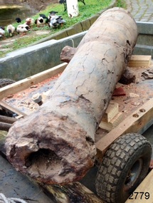
... (At the same meeting, the Board was advised of the recovery of an anchor from the wreck of the CHILDREN by Flagstaff Hill divers (Peter Ronald, Colin Goodall and Gary Hayden, and Hank Howey and Andrew Coffee), and its interim relocation in the sea at the end of the Warrnambool Breakwater while awaiting conservation). About the ship CHILDREN 1825-1839: The sailing ship Children was a wooden, three-masted barque constructed of pitch pine in 1825 at Liverpool. ...(At the same meeting, the Board was advised of the recovery of an anchor from the wreck of the CHILDREN by Flagstaff Hill divers (Peter Ronald, Colin Goodall and Gary Hayden, and Hank Howey and Andrew Coffee), and its interim relocation in the sea at the end of the Warrnambool Breakwater while awaiting conservation). About the ship CHILDREN 1825-1839: The sailing ship Children was a wooden, three-masted barque constructed of pitch pine ...In an article dated 26 March 1963, the Warrnambool Standard reported: “A cannon which has lain on the ocean floor since the barque, Children, was wrecked at Childer’s Cove on January 15, 1839, was raised by three Warrnambool skindivers at the weekend … The cannon, weighing about 750 lb. and 4-ft. 6-in. in length … is in excellent order considering the length of time it has remained underwater”. No conservation measures were taken at that time, other than chipping off the marine growth with hammers and cold chisels. The minutes for the 4 February 1974 meeting of the Flagstaff Hill Planning Board recorded that “a cannon recovered some time ago was lying in the garden of [one of the three original divers] and that it could be picked up at any time”. Peter Ronald, past Manager and Diver for Flagstaff Hill, notes that the CHILDREN cannon would have been recovered by the other divers around 1964. When the cannon came into care of Flagstaff Hill, it was given basic conservation relevant to the time. (At the same meeting, the Board was advised of the recovery of an anchor from the wreck of the CHILDREN by Flagstaff Hill divers (Peter Ronald, Colin Goodall and Gary Hayden, and Hank Howey and Andrew Coffee), and its interim relocation in the sea at the end of the Warrnambool Breakwater while awaiting conservation). About the ship CHILDREN 1825-1839: The sailing ship Children was a wooden, three-masted barque constructed of pitch pine in 1825 at Liverpool. It was felt sheathed and was coppered during an upgrade in 1837. The ship was only 29 metres long and 254 tons in weight; it had two decks and a square stern. The James Henty & Co., a pioneering family from Portland, Victoria, purchased the Children in 1837 for use as a coastal trader. The Children, under the command of Captain H. Browne, was on a voyage from Launceston to Adelaide when it foundered in rough conditions at Childers Cove, west of Peterborough, on 14 January 1839. On board were 14 crew members and 24 passengers, including 9 children. The ship’s cargo was awkwardly balanced: it carried 1500 sheep, 8 bullocks, 7 horses, 5000 London house bricks, 6 whaling boats with associated gear, and general trade goods including beef, pork, tobacco, tipe, butter, lime juice, horse hair, curtains, lead shot, beer and spirits. The hurricane-force winds drove the Children into the limestone stack at the entrance to the cove. The seas smashed it into pieces within twenty minutes. The bodies of sixteen of those who had lost their lives were spread across the shore, along with wreckage from the ship and the cargo of animals. Those who survived suffered injuries; they were rescued and taken by horse and cart to Campbell’s farm, near the whaling station at Port Fairy. They arrived at Portland eleven days after the wreck. The wrecking of the Children is one of colonial Victoria’s earliest and most significant maritime disasters. Little is left to mark the tragedy, apart from some house bricks intended for the Henty family’s Portland Bay settlement. Artefacts recovered in the 1960s to early 1970s include this signal cannon, an anchor, the bottom half of her ship’s bell, and two portions of a ship’s fitting, at one time thought to be a brass porthole frame, London housing bricks and timber flooring. Despite its poor condition, the CHILDREN’s signal cannon remains an important and interpretable record of its demise. From 2015, the CHILDREN cannon has been undergoing the first stages of further conservation.The signal cannon recovered from the Children's wreck is significant as part of the original fittings of the early 19th-century barque. It is an example of maritime defence in the early to mid-19th century. The 1839 wreck and recovered artefacts are examples of the construction methods and materials used in that era and can be used to study the evolution of shipbuilding methods and principles. The wreck of the Children is of state significance as one of colonial Victoria’s earliest and most significant maritime disasters, and one of the first vessels lost in the Western District. This is recognised by its inclusion on the Victorian Heritage Register, VHR No. S116. Little is left on the seabed to mark the tragedy, apart from some of the house bricks intended for the Henty settlement. Signal cannon: a 1.3 metre iron 6pdr cannon recovered from the wreck of the CHILDREN. The shape of the cannon tapers from a thick round breech to a flared muzzle, with an 8-centimetre bore, and two side trunnions for pivoting on a wooden gun carriage. It was recovered from the shipwreck site of the CHILDREN by local divers in 1963. This small muzzle-loading signal cannon is in poor and unrestored condition. The cannon’s upper profile of smooth grey metal casing has corroded off, leaving an extensively oxidised rough red surface of crumbling iron. The bottom half of the cannon remains intact, although the outer smooth casing also appears to be separating from the iron core of the barrel. The original grey casting is also missing from the breech and muzzle ends of the cannon. Corrosion and spalling of the upper surface layer of the cannon have removed the maker’s marks and specificationsflagstaff hill, flagstaff hill maritime museum and village, warrnambool, maritime museum, maritime village, great ocean road, shipwreck coast, shipwreck artefact, children, barque, three-masted, liverpool, childer’s cove, port campbell, 1839 shipwreck, 1939 wreck, james henty and co, henty brothers, captain h. browne, first mate t. gay, second mate w. wentworth, portland, portland bay, 1939, ship’s cannon, signal cannon, conservation of marine artefacts, 6pdr small bore cannon, defence -
 Flagstaff Hill Maritime Museum and Village
Trunk
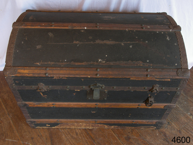
... flagstaff hill warrnambool shipwrecked-coast flagstaff-hill flagstaff-hill-maritime-museum maritime-museum shipwreck-coast flagstaff-hill-maritime-village Trunk wooden Baltic pine with grey & white stripe interior. ...Trunk wooden Baltic pine with grey & white stripe interior. Has curved top with 3 wood supports on front & 3 on lid. 2 metal handles each end. Is blackflagstaff hill, warrnambool, shipwrecked-coast, flagstaff-hill, flagstaff-hill-maritime-museum, maritime-museum, shipwreck-coast, flagstaff-hill-maritime-village -
 Federation University Historical Collection
Plan, Sovereign Hill Recreation Reserve and Surrounds
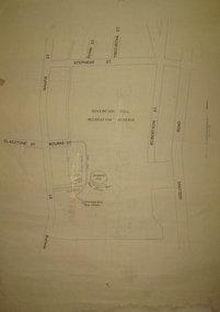
... It shows the Sovereign Hill Recreation Rerserve, including the swimming pool located near the Sovereign Hill Trig Point, showers, toilets, kiosk, bandstand and pine trees. The plan also depicts the Ballarat East streets surrounding Sovereign hill, including Geelong Road, Magpie Street, Stephens Street, Tregurtha Street, Dunn Street, Bourke Street, Gladstone Street and Robertson Street. ...It shows the Sovereign Hill Recreation Rerserve, including the swimming pool located near the Sovereign Hill Trig Point, showers, toilets, kiosk, bandstand and pine trees. The plan also depicts the Ballarat East streets surrounding Sovereign hill, including Geelong Road, Magpie Street, Stephens Street, Tregurtha Street, Dunn Street, Bourke Street, Gladstone Street and Robertson Street. ...This map was probably produced around the time that the Sovereign Hill Museums Association was established. A simple plan with black marking on paper. It shows the Sovereign Hill Recreation Rerserve, including the swimming pool located near the Sovereign Hill Trig Point, showers, toilets, kiosk, bandstand and pine trees. The plan also depicts the Ballarat East streets surrounding Sovereign hill, including Geelong Road, Magpie Street, Stephens Street, Tregurtha Street, Dunn Street, Bourke Street, Gladstone Street and Robertson Street. The scale is 2 chains to 1 inch.sovereign hill, swimming pool -
 Federation University Historical Collection
Book, Final recommendations Ballarat Study Area Land Conservation Council, Victoria, 1982, 1982
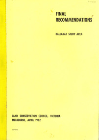
... pine plantations...langi ghiran state park...mount buangor state park...enfield state park...ballarat-creswick regional park...rossbridge...black lake...flax mill swamp...dereel lagoon...lake bolac...lake wongan...langi ghiran reservoir...gong gong reservoir...pincotts reservoir...beales reservoir...wilsons reservoir...moorabool reservoir...korweinguboora...korweinguborra reservoir...learmonth bores...sago hill...land conservation authority ballarat endowment plantations pine plantations langi ghiran state park mount buangor state park enfield state park ballarat-creswick regional park rossbridge black lake flax mill swamp dereel lagoon lake bolac lake wongan langi ghiran reservoir gong gong reservoir pincotts reservoir beales reservoir wilsons reservoir moorabool reservoir korweinguboora korweinguborra reservoir learmonth bores sago hill illabarook reservoir ballarat water commission dunneworthy mount cole mont lonarch ben major waterloo trawalla linton ross creek canadian shepherds flat lal lal mount doran raglan chute carngham buninyong watsons hill enfield cape clear illabrook rokewood junction mount warrenheip nerrina jubilee golden stream australasian deep lead mine happy valley school piggoreet berringa bulldog ballarat common wildlife water timber flora rivers geology agriculture warrenheip biodiversity Yellow soft covered report of 95 pages . ...Yellow soft covered report of 95 pages . The contents of the report include: Parks, reference areas, wildlife reserves, water production, hardwood production, softwood production, flora Reserves and Flora and Fauna reserves, bushland reserves, historic area and reserves, rivers and streams, Roadside conservation and Highway parks, Education areas and School Plantations, Lake Reserves, geological reserves, recreation, scenic reserves, agriculture, mineral and stone production, utilities and survey, township land, Uncommitted Land, military training, other reserves and public land. Maps include: The Study area 1: 250 000 Supplementary Mapsland conservation authority, ballarat, endowment plantations, pine plantations, langi ghiran state park, mount buangor state park, enfield state park, ballarat-creswick regional park, rossbridge, black lake, flax mill swamp, dereel lagoon, lake bolac, lake wongan, langi ghiran reservoir, gong gong reservoir, pincotts reservoir, beales reservoir, wilsons reservoir, moorabool reservoir, korweinguboora, korweinguborra reservoir, learmonth bores, sago hill, illabarook reservoir, ballarat water commission, dunneworthy, mount cole, mont lonarch, ben major, waterloo, trawalla, linton, ross creek, canadian, shepherds flat, lal lal, mount doran, raglan, chute, carngham, buninyong, watsons hill, enfield, cape clear, illabrook, rokewood junction, mount warrenheip, nerrina, jubilee, golden stream, australasian deep lead mine, happy valley school, piggoreet, berringa, bulldog, ballarat common, wildlife, water, timber, flora, rivers, geology, agriculture, warrenheip, biodiversity -
 Federation University Historical Collection
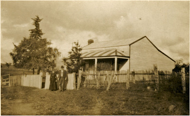
Photograph, Kodak Australia, Frank Wright's Parents at Laura Villa, Smeaton, 1922
... On the left hand side of the photograph is a hill with a large pine tree. The people are Sarah and William Wright and the cottage is "Laura Villa" at Smeaton....On the left hand side of the photograph is a hill with a large pine tree. The people are Sarah and William Wright and the cottage is "Laura Villa" at Smeaton. ...Frank Wright was a renown resident of Smeaton, where he was born. He lived at Laura Villa, and attended Smeaton State School. His father William was a gold miner and his mother's name was Sarah. Their family won many singing and instrumental awards. Frank was tutored by Percy Code and became the Australian Open Cornet Champion by the age of eighteen. A year later, Frank conducted the City of Ballarat Band, and later the Ballarat Soldiers’ Memorial Band. He formed the Frank Wright Frisco Band and Frank Wright and his Coliseum Orchestra. These bands won many South Street awards, and Frank as conductor won many awards in the Australian Band Championship contest. In 1933 Frank Wright sailed to England to conduct the famous St Hilda’s Band and was later appointed Musical Director of the London County Council, where he organized many amazing concerts in parks, in and around the London district. He was made Professor of Brass and Military Band Scoring and conducted at the Guildhall of Music and Drama. Frank was often invited to adjudicate Brass Band Championships around Europe, in Australia, including South Street and in New Zealand. The Frank Wright Medal at the Royal South Street competition is awarded to an individual recognized as making an outstanding contribution to brass music in Australia.Sepia photograph of a man and a woman standing in front of a picket fence which surrounds a timber cottage with a corrugated iron roof, including a striped front verandah roof. On the left hand side of the photograph is a hill with a large pine tree. The people are Sarah and William Wright and the cottage is "Laura Villa" at Smeaton.Printed on back - Post Card, Kodak Australiafrank wright, sarah wright, william wright, laura villa, smeaton, picket fence -
 Flagstaff Hill Maritime Museum and Village
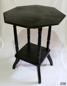
Furniture - Table
... flagstaff hill warrnambool shipwrecked-coast flagstaff-hill flagstaff-hill-maritime-museum maritime-museum shipwreck-coast flagstaff-hill-maritime-village Centre table, hexagonal in shape, coloured cedar, lower shelf supported by four turned columns and finished on four splayed legs. Kauri Pine ...Centre table, hexagonal in shape, coloured cedar, lower shelf supported by four turned columns and finished on four splayed legs. Kauri Pine.flagstaff hill, warrnambool, shipwrecked-coast, flagstaff-hill, flagstaff-hill-maritime-museum, maritime-museum, shipwreck-coast, flagstaff-hill-maritime-village -
 Flagstaff Hill Maritime Museum and Village
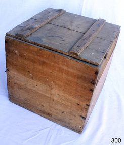
Container - Box
... Flagstaff Hill Warrnambool Shipwrecked-coast Flagstaff-Hill Flagstaff-Hill-Maritime-Museum Maritime-Museum Shipwreck-coast Flagstaff-Hill-Maritime-Village Wooden Box Furniture Storage None. Wooden square handmade box with hinged lid. Made from rough pine ...From the earliest days, humans have furnished their dwellings with the items they needed to survive and over the centuries the wooden chest, storage boxes and trunks have become the most common piece of furniture found in the home. Over time the simple storage chest has evolved into different styles and been modified for different uses: wooden boxes, storage chests, tool chests, treasure chests, blanket boxes and steamer trunks. Wooden chests and trunks have became the most useful, and most versatile piece in furniture’s history. https://www.vineyarddetails.com/blogs/february-2019/history-of-box-makingThe use of the wooden box for storage.Wooden square handmade box with hinged lid. Made from rough pine boards.None.flagstaff hill, warrnambool, shipwrecked-coast, flagstaff-hill, flagstaff-hill-maritime-museum, maritime-museum, shipwreck-coast, flagstaff-hill-maritime-village, wooden box, furniture, storage
