Showing 956 items matching "plan of subdivision"
-
 Eltham District Historical Society Inc
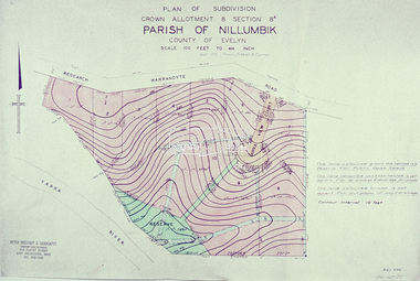
Slide - Photograph, Eltham Shire Council, Plan of Subdivision, Crown Allotment 8, Section 8A, Parish of Nillumbik,County of Evelyn, 1969
... Plan of Subdivision, Crown Allotment 8, Section 8A, Parish of Nillumbik,County of Evelyn......Plan of Subdivision...Eltham District Historical Society Inc 728 Main Rd Eltham melbourne Carter Infrastructure Map North Warrandyte Pain Parish of Nillumbik Plan of Subdivision planning Research-Warrandyte Road Sibbel Subdivison Lots C1, Pain, Sibbel and Carter, Research-Warrandyte Road, North Warrandyte, 4 August 1969 35mm colour positive transparency blue Agfacolour Service plastic mount Plan of Subdivision, Crown Allotment 8, Section 8A, Parish of Nillumbik,County of Evelyn Slide Photograph Eltham Shire Council ...35mm colour positive transparency blue Agfacolour Service plastic mountC1, Pain, Sibbel and Carter, Research-Warrandyte Road, North Warrandyte, 4 August 1969carter, infrastructure, map, north warrandyte, pain, parish of nillumbik, plan of subdivision, planning, research-warrandyte road, sibbel, subdivison lots -
 Eltham District Historical Society Inc
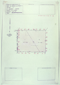
Slide - Photograph, Eltham Shire Council, Plan of Subdivision of Part of Crown Allotment 4, Section 2 at Kangaroo Ground, Parish of Nillumbik, County of Evelyn, 1969
... Plan of Subdivision of Part of Crown Allotment 4, Section 2 at Kangaroo Ground, Parish of Nillumbik, County of Evelyn......Plan of Subdivision...Eltham District Historical Society Inc 728 Main Rd Eltham melbourne Infrastructure Kangaroo Ground Kangaroo Ground-St Andrews Rd Kimse Map Plan of Subdivision planning Subdivison Lots C6, Kimse, Kangaroo Ground-St Andrews Road, 4 August 1969 35mm colour positive transparency blue Agfacolour Service plastic mount Plan of Subdivision of Part of Crown Allotment 4, Section 2 at Kangaroo Ground, Parish of Nillumbik, County of Evelyn Slide Photograph Eltham Shire Council ...35mm colour positive transparency blue Agfacolour Service plastic mountC6, Kimse, Kangaroo Ground-St Andrews Road, 4 August 1969infrastructure, kangaroo ground, kangaroo ground-st andrews rd, kimse, map, plan of subdivision, planning, subdivison lots -
 Whitehorse Historical Society Inc.
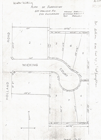
Document, Walter Wicking Plan of Subdivision, ?1952
... Walter Wicking Plan of Subdivision...Plan of subdivision for Wicking Court, South Blackburn....Walter Wicking Plan of Subdivision Document Document ...Plan of subdivision for Wicking CourPlan of subdivision for Wicking Court, South Blackburn.Plan of subdivision for Wicking Courland subdivision, wicking court, blackburn south, wicking, walter benjamin, holland road -
 Peterborough History Group
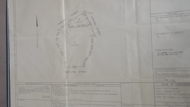
Map - survey of Hamilton St wetland, Plan of Subdivision Hamilton Street
... Plan of Subdivision Hamilton Street...A3 plan of subdivision showing the outline of the swamp bounded by Hamilton St, Charles St and Cumming St. ...Plan of Subdivision Hamilton Street Map survey of Hamilton St wetland ...Subdivided to preserve the wetland, locals estimate it occurred between 1976 and 1983A3 plan of subdivision showing the outline of the swamp bounded by Hamilton St, Charles St and Cumming St. peterborough, survey map, golden pond -
 Kew Historical Society Inc
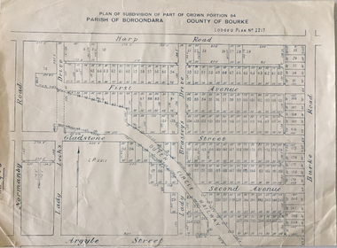
Plan - Subdivision Plan, Plan of Subdivision of Part of Crown Portion 84 / Parish of Boroondara / County of Bourke / Lodged Plan No. 2217, Twentieth Century
... Subdivision Plan...Plan of Subdivision of Part of Crown Portion 84 / Parish of Boroondara / County of Bourke / Lodged Plan No. 2217...subdivisions of land in Kew. The periods that she identified included 1845-1880, 1880-1893, 1893-1921, 1921-1933, 1933-1943, and Post-War Development. These periods were selected as they represented periods of rapid growth or decline in urban development. An obvious starting point for Sanderson’s groupings involved population growth and the associated economic cycles. These cycles also highlighted urban expansion onto land that was predominantly rural, although in other cases it represented the decline and breakup of large estates. A number of the plans...Undated Plan of Subdivision of Crown Portion 84 in what is now Kew. ...The area shown is bordered by Burke Road, Harp Road, Arglye Road and Normanby Road. Plan of Subdivision of Part of Crown Portion 84 / Parish of Boroondara / County of Bourke / Lodged Plan No. 2217 Plan Subdivision Plan ...Pru Sanderson, in her groundbreaking ‘City of Kew Urban Conservation Study : Volume 2 - Development History’ (1988), summarised the periods of urban development and subdivisions of land in Kew. The periods that she identified included 1845-1880, 1880-1893, 1893-1921, 1921-1933, 1933-1943, and Post-War Development. These periods were selected as they represented periods of rapid growth or decline in urban development. An obvious starting point for Sanderson’s groupings involved population growth and the associated economic cycles. These cycles also highlighted urban expansion onto land that was predominantly rural, although in other cases it represented the decline and breakup of large estates. A number of the plans in the Kew Historical Society’s collection can also be found in other collections, such as those of the State Library of Victoria and the Boroondara Library Service. A number are however unique to the collection.The Kew Historical Society collection includes almost 100 subdivision plans pertaining to suburbs of the City of Melbourne. Most of these are of Kew, Kew East or Studley Park, although a smaller number are plans of Camberwell, Deepdene, Balwyn and Hawthorn. It is believed that the majority of the plans were gifted to the Society by persons connected with the real estate firm - J. R. Mathers and McMillan, 136 Cotham Road, Kew. The Plans in the collection are rarely in pristine form, being working plans on which the agent would write notes and record lots sold and the prices of these. The subdivision plans are historically significant examples of the growth of urban Melbourne from the beginning of the 20th Century up until the 1980s. A number of the plans are double-sided and often include a photograph on the reverse. A number of the latter are by noted photographers such as J.E. Barnes.Undated Plan of Subdivision of Crown Portion 84 in what is now Kew. The area shown is bordered by Burke Road, Harp Road, Arglye Road and Normanby Road.subdivision plans -- kew (vic), harp road, burke road, normanby road, lady loch's drive, gladstone street, second avenue, first avenue -
 Whitehorse Historical Society Inc.
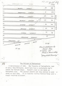
Document, Plan of Subdivision, 1861
... Plan of Subdivision...Copy of plan of subdivision by Patrick Riley of Section 77, Parish of Nunawading 'Springfield Township' 1861. ...Bounded by Whitehorse Road, Walker's Road, (now known as Springvale Road) and Springfield Road Plan of Subdivision Document Document ...Copy of plan of subdivision by Patrick RileyCopy of plan of subdivision by Patrick Riley of Section 77, Parish of Nunawading 'Springfield Township' 1861. Bounded by Whitehorse Road, Walker's Road, (now known as Springvale Road) and Springfield RoadCopy of plan of subdivision by Patrick Rileyland sales, riley, patrick, whitehorse road, nunawading, walkers road, springfield road, black street, robertson street, sandy street, burnt street, luckie street, bridge street, creek street, koonung street, thompson street -
 Bendigo Historical Society Inc.
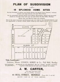
Document - RANDALL COLLECTION: PLAN OF SUBDIVISION OF 18 SPLENDID HOME SITES, Sat. 18th May 1929
... RANDALL COLLECTION: PLAN OF SUBDIVISION OF 18 SPLENDID HOME SITES...Document, Plan of Subdivision of 18 Splendid Home Sites. Having frontages to Albion and Clark Streets and Grand View Cresent, between Condon and Ligar Streets, just pass Neale Street. ...Document RANDALL COLLECTION: PLAN OF SUBDIVISION OF 18 SPLENDID HOME SITES ...Document, Plan of Subdivision of 18 Splendid Home Sites. Having frontages to Albion and Clark Streets and Grand View Cresent, between Condon and Ligar Streets, just pass Neale Street. Title Certificate: Solicitors, Messrs. Cohen, Kirby & Co, Pall Mall, Bendigo. J.W. Carter 61 Bull Street, Bendigo, ''The Agent Who Knows How''.J.B.Ross, Print, Bendigodocument, bendigo businesses, j. w. carter, cohen kirby & co. -
 Ringwood and District Historical Society
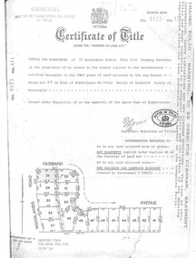
Document, Certificate of Title Vol 8633 Fol 471, Plan of Subdivision No. 73512, Parish of Ringwood, County of Mornington
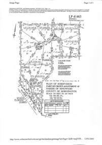
... Certificate of Title Vol 8633 Fol 471, Plan of Subdivision No. 73512, Parish of Ringwood, County of Mornington....Issued under Regulation 12 on the approval of the above Plan of Subdivision. Derived from Vol 8618 Fol 718, 26/8/1966. ...Certificate of Title Vol 8633 Fol 471, Plan of Subdivision No. 73512, Parish of Ringwood, County of Mornington. ...A4 Title Search Enquiry printout dated 2003, with Subdivision Map including Fairbank Avenue and Woodlands Road, Heathmont, Vic.Issued under Regulation 12 on the approval of the above Plan of Subdivision. Derived from Vol 8618 Fol 718, 26/8/1966. Proprietor - Donald Ian Carmichael of 37 Dorrington Avenue Glen Iris. -
 Ringwood and District Historical Society
Document, Property Research Notes - Reaghill, Ringwood East, Victoria. Appendix 4 - Plan of Subdivision No. 41463 and history notes by Ian and Margaret McKellar - 1996
... Appendix 4 - Plan of Subdivision No. 41463 and history notes by Ian and Margaret McKellar - 1996....Plan of Subdivision LP41463 - Part of Crown Allotment 43, Parish of Ringwood, County of Mornington. ...Appendix 4 - Plan of Subdivision No. 41463 and history notes by Ian and Margaret McKellar - 1996. ...Plan of Subdivision LP41463 - Part of Crown Allotment 43, Parish of Ringwood, County of Mornington. Map includes Bedford Road, Homebush Court, Vista Avenue and Vista Court, Heathmont. Allotments include LP201659, LP139446, LP115253, LP207494, LP216905, PS335874, LP206161, PS305345, PS300083, LP92899."Reaghill”; a 30 acre property in Bedford Road, Heathmont was bought from the Blood family about 1910 by Mr Seymour Davies as a weekend retreat from his busy life as a manager with the Glenferrie (or Hawthorn) branch of the English, Scottish and Australian (ES&A) Bank. He and his family came by train to Ringwood and then drove a pony cart up Bedford Road to a gateway at about number 139 and then a long drive, which wound up to the top of the hill. There was a wonderful view of Mount Dandenong which later became obliterated by tall eucalyptus trees. The land which became “Reaghill” was part of an 80 acre crown land sale to Mr Robert Blood on 12 March 1872. More information on the Blood family involvement with the area is given on pages 13-17 of the original 1974 edition of Hugh Anderson, Ringwood, Place of Many Eagles. Another section of this land was bought by Mr Frank L Walker and subsequently became "Wombalano Park". There is a quarry on the property from which stone was used for the long driveway. The garden was mainly left natural although we have two large Liquidamber trees which were planted by his wife Dora Davies (nee Hall). Surely these were some of the first to be planted in Melbourne gardens. A small weatherboard, galvanised iron roofed cottage was built on the top of the hill. At the time the house was built there was a strike of plasterers - as a result it was lined with timber, an unusual combination at that time. The Davies had a daughter and two sons - Dora (born 1897), Geoffrey (1900), John (1902). All studied medicine at Melbourne and practised, Geoffrey in Sydney, John in general practice Melbourne while Dora went to England in the 1930s and never returned. John and Dora married in 1933 and 1938 respectively and had families. Soon after the beginning of the 1939-45 war Geoffrey enlisted in the AIF as a Medical Officer and was in Singapore when it fell to the Japanese. He spent the remaining war years in various POW camps, including Changi and others in Malaya and Thailand. While there he earned the gratitude of his fellows by his innovative use of available plants to treat tropical diseases. After this war Geoffrey returned to Melbourne and worked as a pathologist at the. Heidelberg Repatriation Hospital while living for part of the time at "Reaghill". Seymour Davies died in October 19-35 and his wife, Dora, in February 1945. Of their children, John died in 1976, Dora in 1985 and Geoffrey in 1986. In July 1968 Geoffrey moved to East Ringwood and the two acre house block* and an adjacent one were sold to Dr James Hamilton Kelly, then of New York State, USA (Title Vol 8740 folio 991). As far as is known he never lived there. The house was let to a Mr and Mrs Ingamels for some years. The relatively fertile lower slopes on the south side of the land were cleared and farmed by descendants of the Blood family. At the time of the 1957 subdivision there were clear signs of the ploughed area. It was said that they used to grow strawberries in those paddocks. In about 1955 Dr Geoff Davies decided to sub-divide the property, he was unmarried and found it too large to maintain. Initially five of the seven normal house sized blocks fronting Bedford Road were sold and in about 1957 the remainder, was divided into 15 blocks (averaging nearly two acres) and put on the market. These were sold for £1000 ($2000) per acre. Homebush Court and Vista Court were formed to give access to- these blocks. The Homebush Court blocks have close access to Heathmont and the others to East Ringwood although all are lumped into East Ringwood by the municipal and postal authorities. The name "Reaghill" possibly comes from the Davies family's Irish origins. Homebush Court was named by Geoff Davies from the Sydney suburb of that name where he had lived in the 1930s. It was originally the name of a property owned by one of the early NSW Governors. Vista was a reminder to Geoff Davies of the once-grand views he remembered seeing from the hilltop. The earlier history in this article was recounted by my mother, a niece of Mr Seymour Davies, who remembered coming on a great outing to "Reaghill" as a child. Other recollections are from our own conversations with Geoff Davies. Ian and Margaret McKellar. 16 January, 1996 -
 Greensborough Historical Society
Plan, Plan of Manatunga Circuit Greensborough subdivision, 1970_
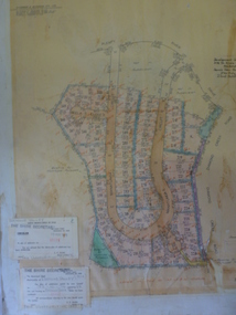
... Plan of Manatunga Circuit Greensborough subdivision...Plan of subdivision. Part of Crown Portion 3. Parish of Nillumbik, County of Evelyn....Plan of subdivision. Printed on buff paper, hand coloured. ...Plan of Manatunga Circuit Greensborough subdivision Plan O'Connor and Beveridge Pty Ltd ...Plan of Manatunga Circuit subdivision. Prepared by O'Connor and Beveridge (land surveyors) for Development Underwriting (developers). Plan of subdivision. Part of Crown Portion 3. Parish of Nillumbik, County of Evelyn.An original example of a subdivision plan in the expanding suburb of Greensborough. The 1960s and 1970s saw this area develop from a rural farming area to a suburb.Plan of subdivision. Printed on buff paper, hand coloured. Mounted on cardboard. Includes 2 small cards attached.Various handwritten comments. Small cards from Survey Branch, Office of Titles.greensborough, manatunga circuit, diamond creek road, plenty river drive -
 Ringwood and District Historical Society
Plan, Plan of Subdivision No.11498 with handwritten costing notations - East Ringwood Central Estate c.1948
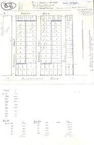
... Plan of Subdivision No.11498 with handwritten costing notations - East Ringwood Central Estate c.1948...Plan of Subdivision No. 11498, Part of Crown Allotment 27, Parish of Ringwood, County of Mornington, (Certificate of Title Vol 5120 Fol 1023945). ...Drainage easement 6 feet wide shaded blue. Plan of Subdivision No.11498 with handwritten costing notations - East Ringwood Central Estate c.1948 Plan ...Two handwritten pages showing layout of Subdivision no 11498 with surveyor notations including property sizes and road construction cost calculations. Drainage easement 6 feet wide shaded blue.Plan of Subdivision No. 11498, Part of Crown Allotment 27, Parish of Ringwood, County of Mornington, (Certificate of Title Vol 5120 Fol 1023945). Owner Mr Vogel. Subdivision includes Knaith Road, Northwood Street, Langley Street, Bondi Street, and Government Road (later Alexandra Road), Ringwood East. G. Parsons & Sons, Licensed Surveyors, 389 Flinders Lane (Melbourne). -
 Ringwood and District Historical Society
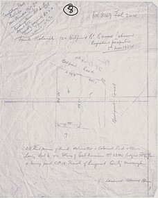
Map, Plan of Subdivision - Canterbury Park Estate, Ringwood East, Victoria - 1954
... Plan of Subdivision - Canterbury Park Estate, Ringwood East, Victoria - 1954...Frank Kolarch 124 Bedford Road Ringwood, Labourer, Registered proprietor 5th November 1954. Lot 6 Plan of Subdivision no. 23805. Part of CP18, Parish of Ringwood, County of Mornington....Frank Kolarch 124 Bedford Road Ringwood, Labourer, Registered proprietor 5th November 1954. Lot 6 Plan of Subdivision no. 23805. Part of CP18, Parish of Ringwood, County of Mornington. ...Hand drawn page with diagram of map and property title information - three residential allotments on Bedford Road and Bedford Court, Ringwood East.Vol 8069 Fol 204. Canterbury Park Estate T.M. Burke Pty Ltd. Purchase price lot 6 £525 Deposit £55. Monthly payments £11. Terms 7 years, Interest 4-1/2%. Frank Kolarch 124 Bedford Road Ringwood, Labourer, Registered proprietor 5th November 1954. Lot 6 Plan of Subdivision no. 23805. Part of CP18, Parish of Ringwood, County of Mornington. -
![Map, Plan of Subdivision [Allotments along Lerderderg, George and McFarland Streets]](/media/collectors/5e461d8021ea67224c82f2a1/items/675d7243165f146b8adfc656/item-media/675d72d7165f146b8adfc859/item-fit-380x285.jpg?cb=6) Bacchus Marsh & District Historical Society
Bacchus Marsh & District Historical SocietyMap, Plan of Subdivision [Allotments along Lerderderg, George and McFarland Streets]
... Plan of Subdivision [Allotments along Lerderderg, George and McFarland Streets]...Inscribed at the top of the map are the words, 'Plan of Subdivision of Cr Pors (Crown Portions) 12 & 13 & Allotments 1,2,3,4, Block 3, Parish of Korkuperrimul, County of Bourke'. ...Inscribed at the top of the map are the words, 'Plan of Subdivision of Cr Pors (Crown Portions) 12 & 13 & Allotments 1,2,3,4, Block 3, Parish of Korkuperrimul, County of Bourke'. ...This map shows allotments of land on the northern side of Lerderderg Street from Gisborne Road through to the approximate site of the present day Bacchus Marsh Primary School. There are also allotments shown on the southern side of McFarland Street between George Street and Gisborne Road. Larger allotments of land are shown extending northwards towards Masons Lane. Inscribed at the top of the map are the words, 'Plan of Subdivision of Cr Pors (Crown Portions) 12 & 13 & Allotments 1,2,3,4, Block 3, Parish of Korkuperrimul, County of Bourke'. The date of the map has not been established but the absence of the Bacchus Marsh Primary School on the map suggests it may have been produced prior to 1865 when the primary school was built in Lerderderg Street.Single page map showing house block size land allotments in the Lerderderg, George Street and McFarland Street area of Bacchus Marsh with larger allotments north of this area towards Masons Lane also shown. Scale 150 feet to 1 inch. Part of a set of maps which are pasted into a bound volume containing 76 maps or plans in total. High resolution digital image stored on BMDHS computer network. bacchus marsh victoria maps, lerderderg street land allotments, mcfarland street land allotments -
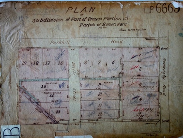 Kew Historical Society Inc
Plan - Subdivision Plan, J R Mathers & McMillan, Plan of Subdivision of Part of Crown Portion 83 at Kew : LP6669, 1923-1939
... Subdivision Plan...Plan of Subdivision of Part of Crown Portion 83 at Kew : LP6669...subdivision represents an attempt by auctioneers, rather than town planners to create an urban environment from larger residential allotments or in many cases farmland. Existing streets such as Parkhill and Normanby Roads provided a convenient starting point for the surveyors, but the Road named ‘Street Street’ indicates the role of the private surveyor in creating streets. Given that a number of allotments are listed as sold on the plan...Hand-drawn subdivision plan of 19 lots facing Parkhill Road, Normanby Road, and an unnamed street [now Cecil Street] in Kew....Plan of Subdivision of Part of Crown Portion 83 at Kew : LP6669 Plan Subdivision Plan J R Mathers & McMillan ...In 1888, in the section of Park Hill Road between Belmont Avenue and Normanby Road there was only one street running between Park Hill Road and Cotham Road. This was Park Road, later to be named Adeney Avenue. Subsequent 20th century subdivisions created the ‘through roads’ of Cecil Street, Wimba Avenue, Florence Avenue, Marshall Avenue, Uvadale Road, and Barrington Avenue. This subdivision represents an attempt by auctioneers, rather than town planners to create an urban environment from larger residential allotments or in many cases farmland. Existing streets such as Parkhill and Normanby Roads provided a convenient starting point for the surveyors, but the Road named ‘Street Street’ indicates the role of the private surveyor in creating streets. Given that a number of allotments are listed as sold on the plan, the street is presumably Cecil Street. Even those lots that had been sold do not quite match the dimensions of the blocks in this parcel of land today, indicating that either further subdivisions or boundary alterations occurred.Subdivision plans are historically important documents used as evidence for the growth of suburbs in Australia. They frequently provide information about when the land was sold as well as evidence relating to surveyors and real estate and financial agents. The numerous subdivision plans in the Kew Historical Society's collection represent working documents, ranging from the initial sketches made in planning a subdivision to printed plans on which auctioneers or agents listed the prices for which individual lots were sold. In a number of cases, the reverse of a subdivision plan in the collection includes a photograph of a house that was also for sale by the agent. These photographs provide significant heritage information relating house design and decoration, fencing and household gardens.The photograph may also be aesthetically significant depending on the importance of the photographic atelier.Hand-drawn subdivision plan of 19 lots facing Parkhill Road, Normanby Road, and an unnamed street [now Cecil Street] in Kew.Estate Agent notes in ink indicate those lots which had sold.subdivision plans - kew, parkhill road - kew, cecil street - kew, normanby road - kew, cecil street -kew, parkhill road - kew, normanby road - kew, crown portion 83 - kew -
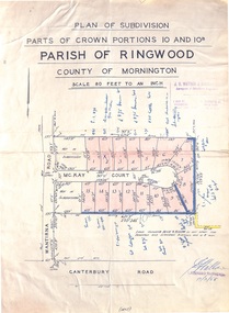 Ringwood and District Historical Society
Map - Plan of Subdivision, Parts of Crown Portions 10 and 10B Parish of Ringwood - 1958
... Plan of Subdivision...Parts of Crown Portions 10 and 10B Parish of Ringwood - 1958 Map Plan of Subdivision ...Folded subdivision map of 15 residential allotments in McKay Court Ringwood, off Wantirna Road north of Canterbury Road. Rubber stamped by Surveyors and Chartered Engineers J.S. Watson & Associates, Mornington and South Yarra, with illegible signature dated 17/2/58. Handwritten notations indicating allotment sale names and amounts or where passed in. Accompanying clipping on scrap paper backing from Land Sale Brochure with description of available services and local facilities and terms of sale - £75 Deposit £10 Monthly. -
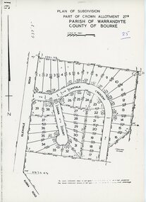 Ringwood and District Historical Society
Map - Plan of Subdivision, Part of Crown Allotment 27B Parish of Warrandyte County of Bourke (undated, circa 1970)
... Plan of Subdivision...Part of Crown Allotment 27B Parish of Warrandyte County of Bourke (undated, circa 1970) Map Plan of Subdivision ...Photocopied subdivision map of 38 residential allotments in Glenvale Road, Cantala Crescent, and Giana Court, north of Kubba Road, Ringwood. -
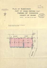 Ringwood and District Historical Society
Map - Plan of Subdivision, Part of Crown Portions 6 & 7, Parish of Ringwood, County of Bourke - 1960
... Plan of Subdivision...Part of Crown Portions 6 & 7, Parish of Ringwood, County of Bourke - 1960 Map Plan of Subdivision ...Copy of land title map on light cardboard backing showing layout and size of 5 residential allotments in Walmer Street and Wantirna Road, Ringwood, Victoria.Ref. 3725 Date 15-8-1960 Amended 7-9-1960. Little & Brosnan, Licensed Surveyors & Engineers, 422 Little Collins Street, Melbourne. Telephone MU 5111. -
 Ringwood and District Historical Society
Map - Plan of Subdivision, Part of Crown Portions 6 Parish of Ringwood, County of Mornington - (Undated, circa 1950s)
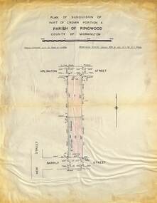
... Plan of Subdivision...Part of Crown Portions 6 Parish of Ringwood, County of Mornington - (Undated, circa 1950s) Map Plan of Subdivision ...Copy of land title map on light cardboard backing showing layout and imperial sizes of 2 residential allotments in Arlington Street and Barkly Street, Ringwood, Victoria. -
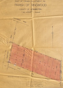
 Ringwood and District Historical Society
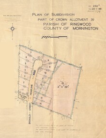
Map - Plan of Subdivision, Part of Crown Allotment 39, Parish of Ringwood, County of Mornington - 1968
... Plan of Subdivision...Part of Crown Allotment 39, Parish of Ringwood, County of Mornington - 1968 Map Plan of Subdivision ...Map showing residential allotments numbered 1 to 14 Headline Court, Heathmont, Victoria, off Bronaldi Street and Yallamba Place. Adjoining lot 15 marked as 2 acres 3 roods 29.8 perches with house and garage.Paul Millar & Associates, Land & Engineering Surveyors, First Floor, 14A Main Street Croydon (Phone) 723 4493. Ref. 232B Date 23.1.68 Amended 12.3.68 & 1.12.71. -
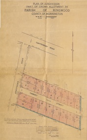
 Ringwood and District Historical Society
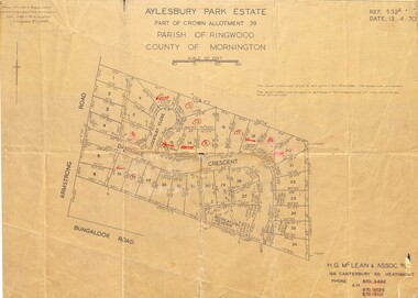
Map - Plan of Subdivision, Aylesbury Park Estate, Part of Crown Allotment 39, Parish of Ringwood, County of Mornington - 1970
... Plan of Subdivision...Aylesbury Park Estate, Part of Crown Allotment 39, Parish of Ringwood, County of Mornington - 1970. Map Plan of Subdivision ...Map showing residential allotments for sale in Armstrong Road, Danielle Crescent and Locksley Close, Heathmont, Victoria.Ref.532A Date 13.4.70. Paul Millar & Associates, Land & Engineering Surveyors, 14A Main Street Croydon (Phone) 723 4493. Ref.532A Date 13.4.70. (Agent) H.G. McLean & Assoc P/L, 166 Canterbury Road Heathmont, Phone 8703422 A.H. 8706726 8700112. -
 Ringwood and District Historical Society
Map - Plan of Subdivision, Part of Crown Allotment 40B, Parish of Ringwood, County of Mornington - 1965
... Plan of Subdivision...Part of Crown Allotment 40B, Parish of Ringwood, County of Mornington - 1965 Map Plan of Subdivision ...Map showing residential allotments numbered 1 to 5 on Heathmont Road and The Greenway, Heathmont, Victoria.Ref. 2937A Date 19 July 1965. Kirkpatrick & Webber, Licensed Surveyors, Civil Engineers & Town Planners, Maroondah Highway, Ringwood Telephone 870 0321. -
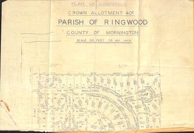 Ringwood and District Historical Society
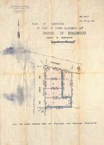
Document - Plan of Subdivision, Part of Crown Allotment 40C, Parish of Ringwood, County of Mornington - (Undated, circa 1960s)
... Plan of Subdivision...Part of Crown Allotment 40C, Parish of Ringwood, County of Mornington - (Undated, circa 1960s) Document Plan of Subdivision ...Top portion (only) of clipped map on light paper backing showing residential allotments on The Boulevard, Wendy Court and Beverley Court, Heathmont, Victoria. -
 Ringwood and District Historical Society
Map - Plan of Subdivision, Part of Crown Allotment 39, Parish of Ringwood, County of Mornington - 1949
... Plan of Subdivision...Part of Crown Allotment 39, Parish of Ringwood, County of Mornington - 1949 Map Plan of Subdivision ...Map showing residential allotments numbered 1 to 12 on Armstrong Road and Louis Street, Heathmont, Victoria.Certification signed and dated by Russell Francis Kinnane, Licensed Surveyor, 18th February, 1949. -
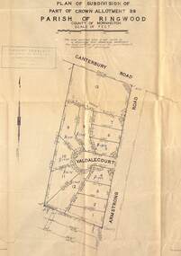 Ringwood and District Historical Society
Map - Plan of Subdivision, Part of Crown Allotment 39, Parish of Ringwood, County of Mornington - (Undated, circa 1950)
... Plan of Subdivision...Part of Crown Allotment 39, Parish of Ringwood, County of Mornington - (Undated, circa 1950). Map Plan of Subdivision ...Map showing residential allotments numbered 1 to 13 on Valdale Court and Armstrong Road off Canterbury Road, Heathmont, Victoria. Richard Rogalsky, Land Surveyor and Town Planner, 25 Napier Street, Essendon (at Essendon Junction) 37-2642 - 37-6570. -
 Ringwood and District Historical Society
Map - Plan of Subdivision, Part of Crown Allotment 39, Parish of Ringwood, County of Mornington - 1949
... Plan of Subdivision...Part of Crown Allotment 39, Parish of Ringwood, County of Mornington - 1949 Map Plan of Subdivision ...Map showing residential allotments numbered 1 to 18 on Armstrong Road and Harriet Street, Heathmont, Victoria.Certification signed and dated by Russell Francis Kinnane, Licensed Surveyor, 12th October, 1949. -
 Ringwood and District Historical Society
Map - Plan of Subdivision, Part of Crown Allotment 4, Parish of Ringwood, County of Mornington - 1925, amended 1980
... Plan of Subdivision...Part of Crown Allotment 4, Parish of Ringwood, County of Mornington - 1925, amended 1980. Map Plan of Subdivision ...Photocopy of subdivision with allotment numbers and property dimensions. Subdivision includes Grant Crescent, Heatherbrae Avenue, Margaret Street, Mary Street, Hillcrest Avenue, Bon View Avenue and Whitehorse Road, Ringwood, Victoria.W.B. & O. McCutcheon Stamp 13.1.25. Declared by W.J. Bonwick 24.12.24. Amended 15.8.80. LP Ref 10506. -
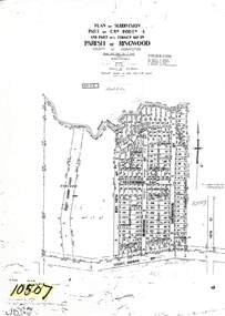 Ringwood and District Historical Society
Map - Plan of Subdivision, Part of Crown Allotment 4, Parish of Ringwood, County of Mornington - 1925
... Plan of Subdivision...Part of Crown Allotment 4, Parish of Ringwood, County of Mornington - 1925 Map Plan of Subdivision ...Photocopy of subdivision with allotment numbers and property dimensions. Subdivision includes Grant Crescent, Heatherbrae Avenue, Bon View Avenue, Burwood Avenue, Sherbrook Avenue and Whitehorse Road, Ringwood, Victoria. Area west of Bon View Avenue marked Electrical Commission East, Excised.W.B. & O. McCutcheon Stamp 13.1.25. Declared by W.J. Bonwick 24.12.24. Councis's consent on plan with F.D3 report. LP Ref 10507. -
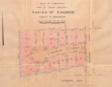 Ringwood and District Historical Society
Map - Plan of Subdivision, Part of Crown Portion 7, Parish of Ringwood, County of Mornington - 1966
... Plan of Subdivision...Map showing layout of and dimensions of 15 numbered allotments on Hammond Street, off Maidstone Street, Ringwood, Victoria Part of Crown Portion 7, Parish of Ringwood, County of Mornington - 1966 Map Plan of Subdivision ...Map showing layout of and dimensions of 15 numbered allotments on Hammond Street, off Maidstone Street, Ringwood, VictoriaRichard Rogalsky, Licensed Surveyor, 23 Napier Street, Essendon (Telephone) 37-2642, 37-2257, Ref 66/821. -
 Ringwood and District Historical Society
Drawing - Plan of Subdivision, Part of Crown Portion 29, Parish of Warrandyte, County of Evelyn, Ringwood - Undated, circa 1945
... Plan of Subdivision...Part of Crown Portion 29, Parish of Warrandyte, County of Evelyn, Ringwood - Undated, circa 1945. Drawing Plan of Subdivision ...Faded hand-drawn map on cardboard backing with taped repairs along fold lines - numbered allotments on Wonga Road, William Street, Andrew Street, Munro Street and Harrison Street, Ringwood. LP7884 -
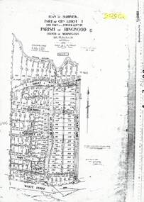
 Ringwood and District Historical Society
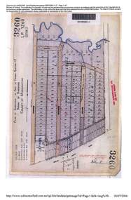
Map - Plan of Subdivision, Part of Crown Portion 12, Parish of Ringwood, County of Mornington - circa 1880s
... Plan of Subdivision...Part of Crown Portion 12, Parish of Ringwood, County of Mornington - circa 1880s Map Plan of Subdivision ...2006 LANDATA photcopy of original subdivision map of 144 allotments in Ringwood Street, Hobart Street, Brisbane Street, Melbourne Street, Adelaide Street, Warrandyte Road and White Horse road, Ringwood. Hatched shading marks area redevelopment and roads discontinued by 1980s.LP3260, LP9589, LP17037, LP29340, LP17774, LP12622, LP5704