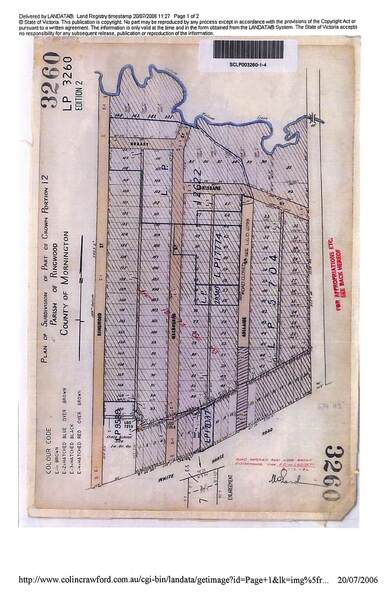
Map - Plan of Subdivision, Part of Crown Portion 12, Parish of Ringwood, County of Mornington - circa 1880s
Untitled image
Reuse this media
Can you reuse this media without permission?Yes
Conditions of use
Attribution-NonCommercial-ShareAlike 4.0 International (CC BY-NC-SA 4.0)
This media item is licensed under Attribution-NonCommercial-ShareAlike 4.0 International (CC BY-NC-SA 4.0). You may share (i.e. copy, distribute, transmit) and rework (i.e. alter, transform, build upon) this item provided that you attribute the content source and copyright holder, and identify any alterations; do not use the content for commercial purposes; and distribute the reworked content under the same or similar license.
Attribution
Please acknowledge the item’s source, creator and title (where known)
2006 LANDATA photcopy of original subdivision map of 144 allotments in Ringwood Street, Hobart Street, Brisbane Street, Melbourne Street, Adelaide Street, Warrandyte Road and White Horse road, Ringwood. Hatched shading marks area redevelopment and roads discontinued by 1980s.