Showing 68 items matching "plenty lane greensborough"
-
 Greensborough Historical Society
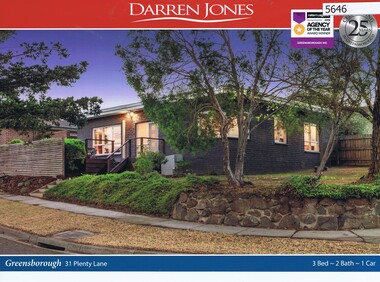
Advertising Leaflet, 31 Plenty Lane Greensborough, 16/06/2018
... 31 Plenty Lane Greensborough...plenty lane greensborough...31 Plenty Lane Greensborough. 3 bedroom home, on 380 sqm, auctioned 16 June 2018, P.I. $660,000 vendor bid, sold July 2018 for $610,000...Greensborough Historical Society 34A Glenauburn Road Lower Plenty Lower Plenty melbourne 31 Plenty Lane Greensborough. 3 bedroom home, on 380 sqm, auctioned 16 June 2018, P.I. $660,000 vendor bid, sold July 2018 for $610,000 plenty lane greensborough Real estate advertising leaflet, 2 sheets, 1 printed in colour both sides 31 Plenty Lane Greensborough Advertising Leaflet Darren Jones ...31 Plenty Lane Greensborough. 3 bedroom home, on 380 sqm, auctioned 16 June 2018, P.I. $660,000 vendor bid, sold July 2018 for $610,000Real estate advertising leaflet, 2 sheets, 1 printed in colour both sidesplenty lane greensborough -
 Eltham District Historical Society Inc
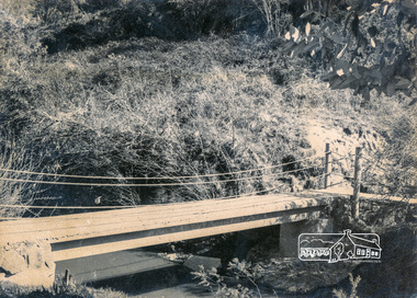
Photograph, Footbridge across Plenty River, Montmorency (leading to Plenty Lane, Greensborough)
... Footbridge across Plenty River, Montmorency (leading to Plenty Lane, Greensborough)...Eltham District Historical Society Inc 728 Main Rd Eltham melbourne infrastructure bridge Footbridge Montmorency plenty river Black and white photograph Footbridge across Plenty River, Montmorency (leading to Plenty Lane, Greensborough) Photograph ...Black and white photographinfrastructure, bridge, footbridge, montmorency, plenty river -
 Greensborough Historical Society
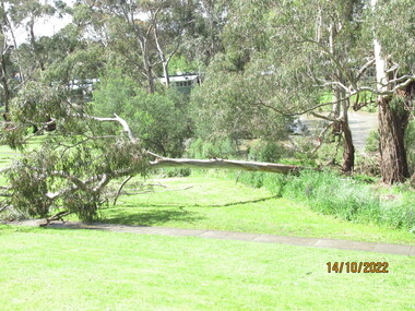
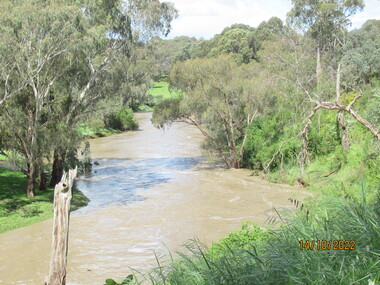
Photograph - Photograph - Digital Image, Peter Simmenauer, Plenty River floods near Plenty Lane 2022, 14/10/2022
... plenty lane greensborough...Plenty River in flood near Plenty Lane Greensborough, October 2022. ...Greensborough Historical Society 34A Glenauburn Road Lower Plenty Lower Plenty melbourne Plenty River in flood near Plenty Lane Greensborough, October 2022. plenty lane greensborough plenty river floods Date stamped: 14/10/2022 Colour digital photographs of river in flood Plenty River floods near Plenty Lane 2022 Photograph Photograph - Digital Image Peter Simmenauer ...Plenty River in flood near Plenty Lane Greensborough, October 2022. Colour digital photographs of river in floodDate stamped: 14/10/2022plenty lane greensborough, plenty river, floods -
 Greensborough Historical Society
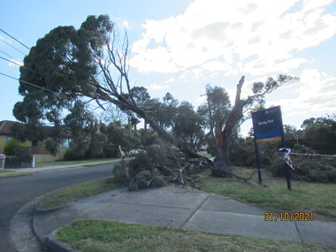
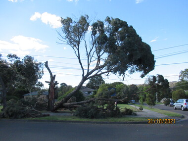
Photograph - Photograph - Digital Image, Peter Simmenauer, Storm damage, Barclay Park 2021, 27/10/2021
... ...plenty lane greensborough...Mackenzie Street & Plenty Lane, Greensborough. SES have lopped some of the dangerous tree limbs, but some are still resting on electric and communication wiring. ...Greensborough Historical Society 34A Glenauburn Road Lower Plenty Lower Plenty melbourne Storm damage incurred on night of 27-28/10/2021 at Barclay Park, cnr. Mackenzie Street & Plenty Lane ...Storm damage incurred on night of 27-28/10/2021 at Barclay Park, cnr. Mackenzie Street & Plenty Lane, Greensborough. SES have lopped some of the dangerous tree limbs, but some are still resting on electric and communication wiring. Colour digital photograph of storm damageDate stamped: 31/10/2021barclay park, mackenzie street greensborough, plenty lane greensborough, storm damage -
 Greensborough Historical Society
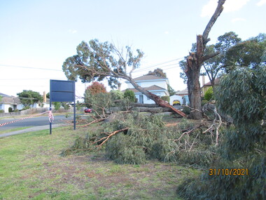
Photograph - Photograph - Digital Image, Peter Simmenauer, Storm damage, Barclay Park 2021, 27/10/2021
... ...plenty lane greensborough...Storm damage incurred on night of 27-28/10/2021 at Barclay Park, corner Mackenzie Street and Plenty Lane, Greensborough. SES have lopped some of the dangerous tree limbs, but some are still resting on electric and communication wiring. ...Greensborough Historical Society 34A Glenauburn Road Lower Plenty Lower Plenty melbourne Storm damage incurred on night of 27-28/10/2021 at Barclay Park, corner Mackenzie Street and Plenty Lane, Greensborough. ...Storm damage incurred on night of 27-28/10/2021 at Barclay Park, corner Mackenzie Street and Plenty Lane, Greensborough. SES have lopped some of the dangerous tree limbs, but some are still resting on electric and communication wiring. Colour digital photograph fo storm damageDate stamped: 31/10/2021barclay park, mackenzie street greensborough, plenty lane greensborough, storm damage -
 Greensborough Historical Society
Photograph - Photograph - Digital Image, Peter Simmenauer, Storm damage, Barclay Park 2021, 27/10/2021
... ...plenty lane greensborough...Mackenzie Street & Plenty Lane, Greensborough. SES have lopped some of the dangerous tree limbs, but some are still resting on electric and communication wiring. ...Greensborough Historical Society 34A Glenauburn Road Lower Plenty Lower Plenty melbourne Storm damage incurred on night of 27-28/10/2021 at Barclay Park, cnr. Mackenzie Street & Plenty Lane ...Storm damage incurred on night of 27-28/10/2021 at Barclay Park, cnr. Mackenzie Street & Plenty Lane, Greensborough. SES have lopped some of the dangerous tree limbs, but some are still resting on electric and communication wiring. Colour digital photograph of storm damageDate stamped: 31/10/2021barclay park, mackenzie street greensborough, plenty lane greensborough, storm damage -
 Greensborough Historical Society
Photograph - Photograph - Digital Image, Peter Simmenauer, Plenty River floods near Plenty Lane 2022, 14/10/2022
... plenty lane greensborough...Plenty River in flood near Plenty Lane October 2022 Greensborough. ...Greensborough Historical Society 34A Glenauburn Road Lower Plenty Lower Plenty melbourne Plenty River in flood near Plenty Lane October 2022 Greensborough. plenty lane greensborough plenty river floods Date stamped: 14/10/2022 Colour digital photograph Plenty River floods near Plenty Lane 2022 Photograph Photograph - Digital Image Peter Simmenauer ...Plenty River in flood near Plenty Lane October 2022 Greensborough. Colour digital photographDate stamped: 14/10/2022plenty lane greensborough, plenty river, floods -
 Greensborough Historical Society
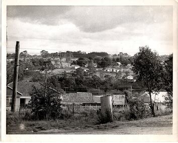
Photograph - Digital Image, From Briar Hill towards Plenty Lane, 1960s
... ...plenty lane greensborough...Greensborough Historical Society 34A Glenauburn Road Lower Plenty Lower Plenty melbourne Briar Hill in the 1960s, looking towards Plenty Lane briar hill plenty lane greensborough Digital copy of black and white photograph From Briar Hill towards Plenty Lane Photograph - Digital Image ...Briar Hill in the 1960s, looking towards Plenty LaneDigital copy of black and white photographbriar hill, plenty lane greensborough -
 Eltham District Historical Society Inc
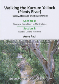
Book, Anne Paul, Walking the Kurrum Yallock (Plenty River), 25 July 2023
... Greensborough Historical Society...Kurrum Yallock...Martins Lane...Plenty...Birrarung Greensborough Historical Society Kurrum Yallock Martins Lane Plenty River yallambie Yarra River Paperback; 74 pages; 17 x 0.5 x 24.4 cm Walking the Kurrum Yallock (Plenty River) Book Book Anne Paul Greensborough Historical Society ...Kurrum Yallock - the Plenty River is Melbourne's third river. It is a defining feature of the region weaving its way through local suburbs and parklands. It is often hidden from general view, emerging at bridges and along its extensive trail network. While diminished since European settlement, the River provides an important environmental, wildlife corridor and recreational resource, along with many links to its settlement heritage. The Kurrum Yallock walks aim to guide people along the River Trail, while providing insight into key aspects of our recent history, an opportunity for reflection and an enhanced enjoyment of the River's special environment and landscape.birrarung, greensborough historical society, kurrum yallock, martins lane, plenty river, yallambie, yarra river -
 Eltham District Historical Society Inc
Document - Folder, Squire family
... Greensborough...Avery sisters...Diamond Valley Community Hospital...Briar Hill Hardware...25-31 Sherbourne Road Briar Hill...Eltham Cottage Hospital...Eltham Methodist Hall...Dr Edward Cordner...Dr Bradbury...Dr Sinclair...Albert Charles Henry Price...Andrew Griffith...Irvine Hewitt...Honorary Justices Association...Eltham Court...William Brinkotter...Were Street Montmorency...Sherbourne Road...Eltham Police Station...Eltham District Play Centre Montmorency branch...Montmorency park...Lower Plenty park...Fitzsimmons Lane...Frederick Vincent Squire Hazel Squire Lorraine Squire Briar Hill Primary School Eltham Shire Councill Sir Dallas Brooks Eltham Country Womens Association Dean Lacey Eltham Community Festival Edward Hughes Hazel Rose Squire nee Hughes Deirdre Squire James Squire Genista House Greensborough Avery sisters Diamond Valley Community Hospital Briar Hill Hardware 25-31 Sherbourne Road Briar Hill Eltham Cottage Hospital Eltham Methodist Hall Dr Edward Cordner Dr Bradbury Dr Sinclair Albert Charles Henry Price Andrew Griffith Irvine Hewitt Honorary Justices Association Eltham Court William Brinkotter Were Street Montmorency Sherbourne Road Eltham Police Station Eltham District Play Centre Montmorency branch Montmorency park Lower Plenty park Fitzsimmons Lane bridge Kangaroo Ground Max McMahon Martin McMahon Clive Tingate Eltham Clay Bird Shooting Club Greensborough Masonic Lodge Mountain View Road Briar Hill Briar Hill Hall H R Squire Family Reserve Hazel Rose Court Montmorency Briar Hill Swimming Pool Centre Briar Hill Timber and Hardware Stan Nedwell Montmorency Football Club Sylvia Davey Briar Hill Girl Guide Group Montmorency Girl Guides Eltham Pony Club Rederick Nedwell Robert Manuell Sutherland Homes Committee Red Cross Eltham Rurl Group Lower Plenty Neighbourhood House Eltham/Diamond Valley Citizens AdviceBureau Cape Otway ratio-operated lighthouse Heidelberg Town Hall Ouyen High School J B Were St Helena Briar Hill Timber and Trading Pty Ltd St Margaret's Church Eltham D V Darwin A W Brinkkotter D C O'Beirne Newspaper clippings, A4 photocopies, etc Squire family Document Folder ...Frederick Vincent Squire established a building business in Briar Hill, later becoming an Eltham Shire Councillor and responsible for many local advances; he was later Shire President. He and wife Hazel with involved with numerous community activities. Their children continued local involvement. Contents Letter Shire Secretary to F V Squite, 2 October 1981. Items of Council business of interest to F V Squire. Letter F V Squire to Shire Seretary, 3 October 1963. Accepting and declining social invitation. Newspaper article: "Wife of former councillor dies", Diamond Valley News, 7 October 1986. Death of Hazel Squire. Another article: "Young Eltham man recovering after horse-riding accident". Diamond Valley News, 7 October 1986. Dean Lacey seriously injured in horse riding accident. Another article: "Everyone loves a community parade.". Diamond Valley News, 7 October 1986. Eltham Community festival will be held again. Typed notes, no author:"Squire Family History", 18 December 1989. Newspaper article: "Briar Hill building recalls early days", Diamond Valley News, 12 November 1991. Biography of Fred Squite. Handwritten note, 30 January 1998: Names and telephone numbers.Newspaper clippings, A4 photocopies, etcfrederick vincent squire, hazel squire, lorraine squire, briar hill primary school, eltham shire councill, sir dallas brooks, eltham country womens association, dean lacey, eltham community festival, edward hughes, hazel rose squire nee hughes, deirdre squire, james squire, genista house greensborough, avery sisters, diamond valley community hospital, briar hill hardware, 25-31 sherbourne road briar hill, eltham cottage hospital, eltham methodist hall, dr edward cordner, dr bradbury, dr sinclair, albert charles henry price, andrew griffith, irvine hewitt, honorary justices association, eltham court, william brinkotter, were street montmorency, sherbourne road, eltham police station, eltham district play centre montmorency branch, montmorency park, lower plenty park, fitzsimmons lane bridge, kangaroo ground, max mcmahon, martin mcmahon, clive tingate, eltham clay bird shooting club, greensborough masonic lodge, mountain view road briar hill, briar hill hall, h r squire family reserve, hazel rose court montmorency, briar hill swimming pool centre, briar hill timber and hardware, stan nedwell, montmorency football club, sylvia davey, briar hill girl guide group, montmorency girl guides, eltham pony club, rederick nedwell, robert manuell, sutherland homes committee, red cross, eltham rurl group, lower plenty neighbourhood house, eltham/diamond valley citizens advicebureau, cape otway ratio-operated lighthouse, heidelberg town hall, ouyen high school, j b were, st helena, briar hill timber and trading pty ltd, st margaret's church eltham, d v darwin, a w brinkkotter, d c o'beirne -
 Greensborough Historical Society
Newspaper Clipping, Diamond Valley Leader, Perk hour traffic, 30/08/2017
... Greensborough Historical Society 34A Glenauburn Road Lower Plenty Lower Plenty melbourne A storm in a coffee cup is brewing on busy Diamond Creek Road. Every time a motorist stops for a morning caffeine fix, six lanes ...A storm in a coffee cup is brewing on busy Diamond Creek Road. Every time a motorist stops for a morning caffeine fix, six lanes of traffic grind to a standstill. Sensors installed at St Sava Serbian Church trigger traffic lights which allow the car in the carpark to enter traffic.News article 1 page, black text.greensborough, coffee stop, diamond creek road, nillumbik council, st sava serbian orthodox church -
 Greensborough Historical Society
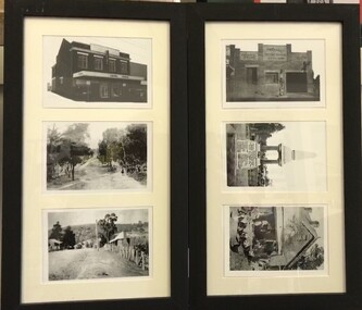
Postcards (framed), Greensborough Historical Society, Greensborough Historical Society Postcards. Series Three, 2016_10
... Greensborough Historical Society. Postcards Frame 1, top to bottom: Ashril Cinema, Main Street 1958; Britnell's Lane 1910;Main Street 1910. Frame 2, top to bottom: Watson's Garage, Watsonia 1920s; Fallen Soldier's Memorial 1927; Willis Vale on the Plenty River 1930....Greensborough Historical Society 34A Glenauburn Road Lower Plenty Lower Plenty melbourne Set of 6 postcards produced for sale by Greensborough Historical Society. Postcards Frame 1, top to bottom: Ashril Cinema, Main Street 1958; Britnell's Lane ...Set of 6 postcards produced for sale by Greensborough Historical Society. Postcards Frame 1, top to bottom: Ashril Cinema, Main Street 1958; Britnell's Lane 1910;Main Street 1910. Frame 2, top to bottom: Watson's Garage, Watsonia 1920s; Fallen Soldier's Memorial 1927; Willis Vale on the Plenty River 1930.6 black and white postcards in 2 black timber frames, under glass.greensborough historical society, main street greensborough, ashril theatre, watsonia, willis vale -
 Greensborough Historical Society
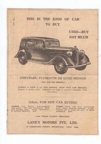
Advertisement - Digital image, Lane's Motors, 12/09/1935
... Greensborough Historical Society 34A Glenauburn Road Lower Plenty Lower Plenty melbourne These advertisements were found in a suitcase donated by a GHS member. The case contained newspapers and other items. This advertisement for Lane's ...These advertisements were found in a suitcase donated by a GHS member. The case contained newspapers and other items. This advertisement for Lane's Motors in Exhibition Street Melbourne is from 1935.Although the advertisement not Greensborough based, it came from a local home.Digital copy of newspaper advertisement.lanes motors -
 Greensborough Historical Society
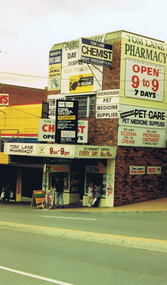
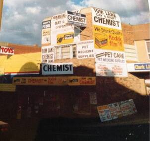
Photograph - Digital image, Frank Solomon, Tom Lane's Pharmacy Main Street Greensborough, 2000c
... Greensborough Historical Society 34A Glenauburn Road Lower Plenty Lower Plenty melbourne Tom Lane's Pharmacy, Main Streets Greensborough. ...Tom Lane's Pharmacy, Main Streets Greensborough. Once an icon of the area, the business has closed but the building remains.A record of the changing face of Greensborough.Digital copy of colour photographgrimshaw street greensborough, main street greensborough, tom lane -
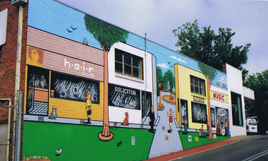
![Photograph - Digital image, Frank Solomon, Greensborough: Mural on Vickers Way [off Main Street], 04/06/2010](/media/collectors/4f729f5697f83e03086015b8/items/58c38e71d0ce9d27549a06d2/item-media/58c38ebbd0ce9d27549a1abd/item-fit-380x285.jpg?cb=6) Greensborough Historical Society
Greensborough Historical SocietyPhotograph - Digital image, Frank Solomon, Greensborough: Mural on Vickers Way [off Main Street], 04/06/2010
... Greensborough Historical Society 34A Glenauburn Road Lower Plenty Lower Plenty melbourne Main Street Greensborough. Mural on Vickers Way (lane ...Main Street Greensborough. Mural on Vickers Way (lane between Main Street and carpark near old pool). The mural was demolished as part of the redevelopment on Main Street.Digital copy of colour photographmain street greensborough, vickers way -
 Greensborough Historical Society
Photograph - Digital image, Frank Solomon, Greensborough: Mural on Vickers Way, 04/06/2010
... Greensborough Historical Society 34A Glenauburn Road Lower Plenty Lower Plenty melbourne Main Street Greensborough. Mural on Vickers Way (lane ...Main Street Greensborough. Mural on Vickers Way (lane between Main Street and carpark near old pool). The mural was demolished as part of the redevelopment on Main Street.Digital copy of colour photographmain street greensborough, vickers way -
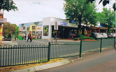 Greensborough Historical Society
Photograph - Digital image, Frank Solomon, Greensborough: Mural on Vickers Way, 04/06/2010
... Greensborough Historical Society 34A Glenauburn Road Lower Plenty Lower Plenty melbourne Main Street Greensborough. Mural on Vickers Way (lane ...Main Street Greensborough. Mural on Vickers Way (lane between Main Street and carpark near old pool). The mural was demolished as part of the redevelopment on Main Street.Digital copy of colour photographmain street greensborough, vickers way -
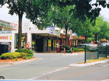 Greensborough Historical Society
Photograph - Digital image, Frank Solomon, Greensborough: Main Street looking toward Vickers Way and mural, 04/06/2010
... Greensborough Historical Society 34A Glenauburn Road Lower Plenty Lower Plenty melbourne Main Street Greensborough. Mural on Vickers Way (lane ...Main Street Greensborough. Mural on Vickers Way (lane between Main Street and carpark near old pool). The mural was demolished as part of the redevelopment on Main Street.Digital copy of colour photographmain street greensborough, vickers way -
 Greensborough Historical Society
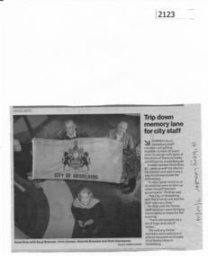
Newspaper clipping, Trip down memory lane for city staff, 07/10/2014
... Greensborough Historical Society 34A Glenauburn Road Lower Plenty Lower Plenty melbourne A reunion of former City of Heidelberg staff will mark 40 years since the City's merger with Shires of Eltham and Diamond Valley to create Banyule. city of heidelberg banyule Heidelberg Leader and date written on page. News clipping, black text, colour image. Trip down memory lane ...A reunion of former City of Heidelberg staff will mark 40 years since the City's merger with Shires of Eltham and Diamond Valley to create Banyule.News clipping, black text, colour image.Heidelberg Leader and date written on page.city of heidelberg, banyule -
 Greensborough Historical Society
Photograph - Digital image, Irma Sartori, Tom Lane's pharmacy, 1970, 1970_
... Greensborough Historical Society 34A Glenauburn Road Lower Plenty Lower Plenty melbourne This photograph of Tom Lane's pharmacy in Main Street Greensborough was taken circa 1970. ...This photograph of Tom Lane's pharmacy in Main Street Greensborough was taken circa 1970. This pharmacy and its owner were well known in Greensborough and surrounding areas. Although no longer a pharmacy, this building remains.Digital copy of colour phototom lane, main street greensborough -
 Greensborough Historical Society
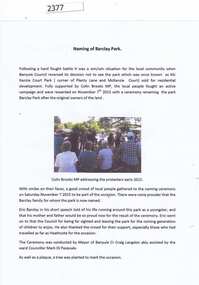
Report and photographs, Barclay Park Greensborough, 07/11/2015
... On November 7, 2015 a small park in Greensborough (previously known as McKenzie Court Park, corner Plenty Lane and McKenzie Court) was renamed as Barclay Park after a local family. henry and Dorothy Barclay farmed Grace Park from 1938. ...Greensborough Historical Society 34A Glenauburn Road Lower Plenty Lower Plenty melbourne On November 7, 2015 a small park in Greensborough (previously known as McKenzie Court Park, corner Plenty Lane and McKenzie Court) was renamed as Barclay Park after a local family. henry and Dorothy Barclay farmed Grace Park from 1938. ...On November 7, 2015 a small park in Greensborough (previously known as McKenzie Court Park, corner Plenty Lane and McKenzie Court) was renamed as Barclay Park after a local family. henry and Dorothy Barclay farmed Grace Park from 1938. Members of the family were present at the ceremony conducted by Banyule Mayor Craig Langdon assisted by Ward Councillor Mark di Pasquale. This open ground was saved from development through the work of local residents.Collection of 6 photographs and a report.barclay family, eric barclay, craig langdon, barclay park -
 Greensborough Historical Society
Photograph - Digital Image, Mitchell's house, 1910c
... Greensborough Historical Society 34A Glenauburn Road Lower Plenty Lower Plenty melbourne The Mitchell house was situated in Hailes Street on land that went to the river. Part of this land is now the skate park in Yando Street off Kalparrin Lane ...The Mitchell house was situated in Hailes Street on land that went to the river. Part of this land is now the skate park in Yando Street off Kalparrin LaneDigital copy of black and white photograph.mitchell family, hailes street greensborough -
 Greensborough Historical Society
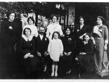
Photograph - Digital image, Hewitt - Keys family group, 1905c
... Greensborough Historical Society 34A Glenauburn Road Lower Plenty Lower Plenty melbourne Group photograph of members of the Hewitt and Keys family. From Nola Parish (nee Iredale) "This is a photo of taken at my grandparents wedding in Heidelberg and includes daughters of Edward Keys and his wife Eliza formally Elizabeth Hewitt who's maiden name was Eliza Joyce daughter of Thomas Joyce and Mary A'Hearn. The Keys family lived in Worns Lane ...Group photograph of members of the Hewitt and Keys family. From Nola Parish (nee Iredale) "This is a photo of taken at my grandparents wedding in Heidelberg and includes daughters of Edward Keys and his wife Eliza formally Elizabeth Hewitt who's maiden name was Eliza Joyce daughter of Thomas Joyce and Mary A'Hearn. The Keys family lived in Worns Lane Yarrambat formally Tancks Corner." A short history of the family is included.Digital copy of black and white studio photograph. Includes short family history.keys family, hewitt family -
 Greensborough Historical Society
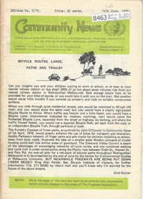
Newsletter, Greenhills and North Greensborough Progress Association, Community News: official journal of the Greenhills and Nth. Greensborough Progress Association and the Apollo Parkways Progress Association.10th June,1976. Edition No. 5/76, 10/06/1976
... Greensborough Historical Society 34A Glenauburn Road Lower Plenty Lower Plenty melbourne This edition includes a report on the The Apollo Parkways Progress Association's May1976 meeting, Bicycle routes, lanes, paths and trails, Thoughts from young cyclists, It can happen to you [youth deaths on our roads], Lament for a traffic statistic, Returning to study, I can do it too!! ...This edition includes a report on the The Apollo Parkways Progress Association's May1976 meeting, Bicycle routes, lanes, paths and trails, Thoughts from young cyclists, It can happen to you [youth deaths on our roads], Lament for a traffic statistic, Returning to study, I can do it too!!, This and that, Cameo of Les James, How does the working mum cope?, From the O'Donnells, Diminishing community spirit?, School news, Greenhills basketball, Scout and Guide news, Nursing Mothers Association. Supplement to "Community News". No. 6/76. Diamond Valley Shire: South-East Councillors' report, From the Chamber Council, Art and craft survey, Letter to the Editor. A digital copy of this Newsletter is available from Greensborough Historical Society. Newsletter, 24 p., illus.greenhills and north greensborough progress association, greenhills, apollo parkways progress association, apollo parkways -
 Greensborough Historical Society
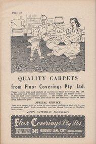
Photograph - Advertisement - Digital Image, Floor Coverings Pty Ltd Melbourne, 1930s
... Greensborough Historical Society 34A Glenauburn Road Lower Plenty Lower Plenty melbourne Advertisement from "Selected recipes from "The Leader" small corner books" (1930s). This advertisement is for Floor Coverings Pty Ltd of Flinders Lane ...Advertisement from "Selected recipes from "The Leader" small corner books" (1930s). This advertisement is for Floor Coverings Pty Ltd of Flinders Lane MelbourneAn example of early 20th century advertisingDigital copy of advertisement from a bookhistoric advertisements, "the leader" small corner books -
 Greensborough Historical Society
Book, Terry Lane, As the twig is bent: the childhood recollections of sixteen prominent Australians: presented by Terry Lane, 1979
... Greensborough Historical Society 34A Glenauburn Road Lower Plenty Lower Plenty melbourne Terry Lane was a radio and television producer for the ABC; in this book he interviews prominent Australians about their childhood. oral history biographies australia - social conditions A collection of interviews with Australians 203 p., illus. ...A collection of interviews with Australians203 p., illus.non-fictionA collection of interviews with Australiansoral history, biographies, australia - social conditions -
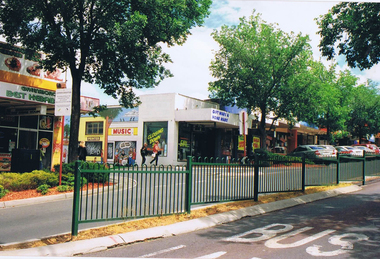
![Photograph - Photograph Collection, Greensborough: Mural on Vickers Way [off Main Street], 2010c](/media/collectors/4f729f5697f83e03086015b8/items/6607af991466534a78efc8cc/item-media/6607afe41466534a78efcce9/item-fit-380x285.jpg?cb=6) Greensborough Historical Society
Greensborough Historical SocietyPhotograph - Photograph Collection, Greensborough: Mural on Vickers Way [off Main Street], 2010c
... Greensborough Historical Society 34A Glenauburn Road Lower Plenty Lower Plenty melbourne Main Street Greensborough. Mural on Vickers Way (lane ...Main Street Greensborough. Mural on Vickers Way (lane between Main Street and carpark near old pool). The mural was demolished as part of the redevelopment on Main Street.2 colour photographsmain street greensborough, vickers way, murals -
 Greensborough Historical Society
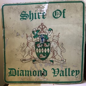
Sign - Boundary Sign, Shire of Diamond Valley, Shire of Diamond Valley boundary sign, 1990s
... Greensborough Historical Society 34A Glenauburn Road Lower Plenty Lower Plenty melbourne The Shire of Diamond Valley was a Local Government Area located about 20 kilometres northeast of Melbourne. The shire covered an area of 74.38 square kilometres and existed from 1964 until 1994. This example of a Boundary Sign was one of many located on the edge of the Shire e.g. at Wattle Glen Station; at Yan Yean Road north of Bannons Lane ...The Shire of Diamond Valley was a Local Government Area located about 20 kilometres northeast of Melbourne. The shire covered an area of 74.38 square kilometres and existed from 1964 until 1994. This example of a Boundary Sign was one of many located on the edge of the Shire e.g. at Wattle Glen Station; at Yan Yean Road north of Bannons Lane; 2 on Plenty Road near Larundel and Bundoora Primary School; one on the Para Road bridge; on Wattletree Road Eltham and on Kurrak Road Yarrambat. According to a former Shire employee, the signs were often stolen as quickly as they were replaced. This sign was removed when the Shire of Diamond Valley was dissolved in 1994 and is signed by a Shire employee, giving it strong provenance.Painted metal sign, cream background with green text and Shire of Diamond Valley crest.Inscribed in felt tip pen on back of sign: SDV: from Nov 1964 to 1994. 30 years. Ron Middleton, By-laws Officer and Ranger, from 9/84 to Nov 94 [signed] R. Middletonshire of diamond valley, boundary signs -
 Greensborough Historical Society
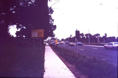
Slide - Photograph, John Ramsdale, Plenty Road near Parade College: Slide 29, 1990s
... Greensborough Historical Society 34A Glenauburn Road Lower Plenty Lower Plenty melbourne Photograph shows a 3-lane road with "Federally funded" sign This is Plenty Road Bundoora, near Parade college. ...Photograph shows a 3-lane road with "Federally funded" sign This is Plenty Road Bundoora, near Parade college.Part of the John Ramsdale collection of slides and audio visual material.Colour photograph scanned from slide.No caption. Printed maker's mark on slide "Kodak Kodachrome Slide"plenty road bundoora, parade college