Showing 27 items matching "plenty river montmorency"
-
 Greensborough Historical Society
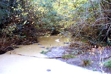
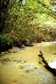
Slide - Photograph, John Ramsdale, Plenty River Montmorency: Slide 112, 1990s
... Plenty River Montmorency: Slide 112...plenty river...montmorency...Photograph shows a river and banks; this is the Plenty River at Montmorency....Greensborough Historical Society 34A Glenauburn Road Lower Plenty Lower Plenty melbourne Photograph shows a river and banks; this is the Plenty River at Montmorency. ...Photograph shows a river and banks; this is the Plenty River at Montmorency.Part of the John Ramsdale collection of slides and audio visual material.Colour photograph scanned from slide.No maker's marks. No caption on slide.plenty river, montmorency -
 Eltham District Historical Society Inc
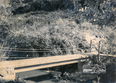
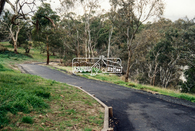
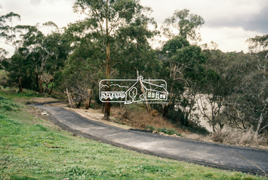
Photograph, Footbridge across Plenty River, Montmorency (leading to Plenty Lane, Greensborough)
... Footbridge across Plenty River, Montmorency (leading to Plenty Lane, Greensborough)...Montmorency...plenty river...Eltham District Historical Society Inc 728 Main Rd Eltham melbourne infrastructure bridge Footbridge Montmorency plenty river Black and white photograph Footbridge across Plenty River, Montmorency (leading to Plenty Lane, Greensborough) Photograph ...Black and white photographinfrastructure, bridge, footbridge, montmorency, plenty river -
 Eltham District Historical Society Inc
Photograph, Marjorie North, Plenty River, Plenty River Trail, Montmorency flowing south behind the tennis courts and cricket/football field, 1985, 1985
... Plenty River, Plenty River Trail, Montmorency flowing south behind the tennis courts and cricket/football field, 1985...montmorency...plenty river...Eltham District Historical Society Inc 728 Main Rd Eltham melbourne Negatives supplied by Marjorie North 1 July 1986 for Montmorency France album montmorency plenty river plenty river trail Kodak CL 200 5093 Roll of 35mm colour negative film, 3 strips Plenty River, Plenty River Trail, Montmorency flowing south behind the tennis courts and cricket/football field, 1985 Photograph Marjorie North ...Negatives supplied by Marjorie North 1 July 1986 for Montmorency France albumRoll of 35mm colour negative film, 3 stripsKodak CL 200 5093montmorency, plenty river, plenty river trail -
 Greensborough Historical Society
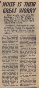
Newspaper Clipping - Digital Image, Noise is their great worry, 21/08/1973
... plenty river montmorency...A family living near the Plenty River in Montmorency are concerned about the noise of mini-bike riders and their effect on local bird life. [1973]...Greensborough Historical Society 34A Glenauburn Road Lower Plenty Lower Plenty melbourne A family living near the Plenty River in Montmorency are concerned about the noise of mini-bike riders and their effect on local bird life. [1973] plenty river montmorency montmorency Digital copy of newspaper article, black text. ...A family living near the Plenty River in Montmorency are concerned about the noise of mini-bike riders and their effect on local bird life. [1973]Digital copy of newspaper article, black text.plenty river montmorency, montmorency -
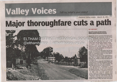
 Greensborough Historical Society
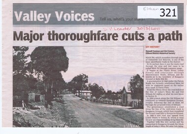
Newspaper clipping, Major Thoroughfare Cuts a Path, 30/3/2011
... ...plenty river...montmorency...Details some of the deviations that Main Road had taken during its earliest years. eltham main road kangaroo ground lower plenty plenty river montmorency south old eltham road bolton street russell yeoman jim connor Hand written date in red pen "30/3/2011". ...A half page newspaper article with a photograph of an early Eltham scene recording the origins of Main Road, Eltham. Written by Eltham District Historical Society members Russell Yeoman and Jim Connor.Details some of the deviations that Main Road had taken during its earliest years.A half page newspaper article with a photograph of an early Eltham scene.Hand written date in red pen "30/3/2011".eltham, main road, kangaroo ground, lower plenty, plenty river, montmorency south, old eltham road, bolton street, russell yeoman, jim connor -
 Greensborough Historical Society
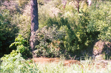
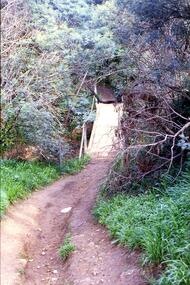
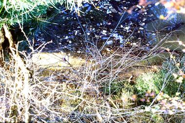
Slide - Photograph, John Ramsdale, Crossing Plenty River: Slide 12, 1990s
... plenty river...erosion...montmorency...Photograph shows erosion on a path to a footbridge over the Plenty River down from George Court Montmorency....Greensborough Historical Society 34A Glenauburn Road Lower Plenty Lower Plenty melbourne Photograph shows erosion on a path to a footbridge over the Plenty River down from George Court Montmorency. Part of the John Ramsdale collection of slides and audio visual material. plenty river erosion montmorency No maker's marks. ...Photograph shows erosion on a path to a footbridge over the Plenty River down from George Court Montmorency.Part of the John Ramsdale collection of slides and audio visual material.Colour photograph scanned from slide.No maker's marks. No caption on slide.plenty river, erosion, montmorency -
 Greensborough Historical Society
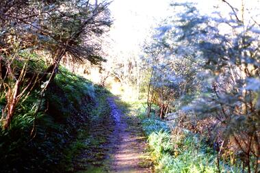
Slide - Photograph, John Ramsdale, Along Plenty River near Para Road: Slide 86, 1990s
... plenty river...para road montmorency...Photograph shows a track through bushland, along the Plenty River near Para Road, possibly Montmorency....Greensborough Historical Society 34A Glenauburn Road Lower Plenty Lower Plenty melbourne Photograph shows a track through bushland, along the Plenty River near Para Road, possibly Montmorency. Part of the John Ramsdale collection of slides and audio visual material. plenty river para road montmorency bushland No maker's marks. ...Photograph shows a track through bushland, along the Plenty River near Para Road, possibly Montmorency.Part of the John Ramsdale collection of slides and audio visual material.Colour photograph scanned from slide.No maker's marks. No caption on slide.plenty river, para road montmorency, bushland -
 Eltham District Historical Society Inc
Document - Folder, Spence, Maxwell
... Maxwell Spence Briar Hill Montmorency Fernside Avenue Briar Hill Montmorency State School Were Street Montmorency Briar Hill State School Stan Stainsby Hee Alcock Ned Haughton Australian Paper Mills Lovitool Tomasetti baker of Greensborough Gladstone Avenue Briar Hill Beaconsfield Road Briar Hill Williams Road Briar Hill Ellis family Hillcrest playfield field Ben Barnett Bill Slater Colin Pugh Clifton Pugh St Helena Karingal Drive St Helena Ted Walker Weidligh Roslind Miller Graham Kennedy Jimmy Beale Leach Street St Helena Plenty River St Faith's Chrch of England Briar Hil St Andrew's Church Briar Hill St Francis Xavier Catholic Church Briar Hill Herbie Wilson Victoria Coffee Palace Eltham Higher Elementary School Kate McKenie Diamond Creek Frank Phillips Wingrove Park Bremner's Park Orrs Dam Pecks Dam Wal Scriver Montmorency Tennis Club Albert Price Hill Fred Balaam Greensborough RSL Joe Poulter Fairfield RSL Youth Club Bristcoes Hardware Merchants Montmorency RSL Jack Shallard Ted Weiland Petrie Park South Riding Ratepaers and Tenants Association Dr Keith Alexander Fred Durham Eltham Shire Council Meruka Park Max Watson Eric Harmer Spence Park Montmorency Mountain View Railway Bridge Montmrency Pre School Lower Plenty Fire Brigade Eltham High School Newspaper clippings, A4 photocopies, etc Spence, Maxwell Document Folder ...Max Spence came to Briar Hill as a child in 1923, and lived in the area for many years. Contents Typed and manuscript notes (2pp missing from MS), undated but ?c1990. "Spence: My Briar Hill and Montmorency." Reminiscences of Maxwell Spence of Briar Hill and Montmorency from 1923. Manuscript notes, AGM 1991, "Max Spence". Newspaper clippings, A4 photocopies, etcmaxwell spence, briar hill, montmorency, fernside avenue briar hill, montmorency state school, were street montmorency, briar hill state school, stan stainsby, hee alcock, ned haughton, australian paper mills, lovitool, tomasetti baker of greensborough, gladstone avenue briar hill, beaconsfield road briar hill, williams road briar hill, ellis family, hillcrest playfield field, ben barnett, bill slater, colin pugh, clifton pugh, st helena, karingal drive st helena, ted walker, weidligh, roslind miller, graham kennedy, jimmy beale, leach street st helena, plenty river, st faith's chrch of england briar hil, st andrew's church briar hill, st francis xavier catholic church briar hill, herbie wilson, victoria coffee palace, eltham higher elementary school, kate mckenie, diamond creek, frank phillips, wingrove park, bremner's park, orrs dam, pecks dam, wal scriver, montmorency tennis club, albert price hill, fred balaam, greensborough rsl, joe poulter, fairfield rsl youth club, bristcoes hardware merchants, montmorency rsl, jack shallard, ted weiland, petrie park, south riding ratepaers and tenants association, dr keith alexander, fred durham, eltham shire council, meruka park, max watson, eric harmer, spence park montmorency, mountain view railway bridge, montmrency pre school, lower plenty fire brigade, eltham high school -
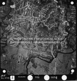
 Eltham District Historical Society Inc
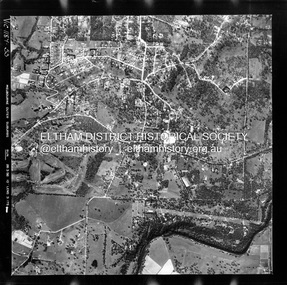
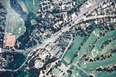
Photograph - Aerial Photograph, Landata, Montmorency / Lower Plenty, Feb. 1956
... Plenty bounded by Rattray Road to north, Yarra River to south, Bolton Street to east and Heidelberg Golf Club to west. Historic Aerial Imagery Source: Landata.vic.gov.au Aerial Photo Details: Project No : 250 Project : MELBOURNE OUTER SUBURBS PROJECT Run : 16A Frame : 53 Date : 02/1956 Film Type : B/W Camera : EAG9 Flying Height : 10000 Scale : 12000 Film Number : 1187 GDA2020 : 37°43'47"S, 145°07'25"E MGA2020 : 334645, 5822519 (55) Melways : 21 D9 (ed. 42) Aerial Photo Lower Plenty Main Road Montmorency Phoebe Mason Collection Bolton Steet Heidelberg Golf Club Rattray Road Electronic PDF file Montmorency / Lower Plenty Photograph Aerial Photograph Landata ...Centred on 20 Panorama Avenue, Lower Plenty bounded by Rattray Road to north, Yarra River to south, Bolton Street to east and Heidelberg Golf Club to west. Historic Aerial Imagery Source: Landata.vic.gov.au Aerial Photo Details: Project No : 250 Project : MELBOURNE OUTER SUBURBS PROJECT Run : 16A Frame : 53 Date : 02/1956 Film Type : B/W Camera : EAG9 Flying Height : 10000 Scale : 12000 Film Number : 1187 GDA2020 : 37°43'47"S, 145°07'25"E MGA2020 : 334645, 5822519 (55) Melways : 21 D9 (ed. 42)aerial photo, lower plenty, main road, montmorency, phoebe mason collection, bolton steet, heidelberg golf club, rattray road -
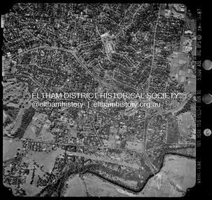
 Eltham District Historical Society Inc
Photograph - Aerial Photograph, Landata, Montmorency / Lower Plenty, Jan. 1962
... Plenty bounded by Hurstbridge Railway Line to north, Yarra River to south, Main Road, Eltham to east and Heidelberg Golf Club to west. Historic Aerial Imagery Source: Landata.vic.gov.au Aerial Photo Details: Project No : 539 Project : MELBOURNE-GEELONG PROJECT Run : 6 Frame : 81 Date : 01/1962 Film Type : B/W Camera : RC5 Flying Height : 6000 Scale : 15840 Film Number : 1524 GDA2020 : 37°43'52"S, 145°07'26"E MGA2020 : 334685, 5822354 (55) Melways : 21 D9 (ed. 42) Aerial Photo Lower Plenty Main Road Montmorency Phoebe Mason Collection Eltham Eltham Lower Park Heidelberg Golf Club Hurstbridge Railway Line Main Road Eltham Yarra River Electronic PDF file Montmorency / Lower Plenty Photograph Aerial Photograph Landata ...Centred on 147 Old Eltham Road, Lower Plenty bounded by Hurstbridge Railway Line to north, Yarra River to south, Main Road, Eltham to east and Heidelberg Golf Club to west. Historic Aerial Imagery Source: Landata.vic.gov.au Aerial Photo Details: Project No : 539 Project : MELBOURNE-GEELONG PROJECT Run : 6 Frame : 81 Date : 01/1962 Film Type : B/W Camera : RC5 Flying Height : 6000 Scale : 15840 Film Number : 1524 GDA2020 : 37°43'52"S, 145°07'26"E MGA2020 : 334685, 5822354 (55) Melways : 21 D9 (ed. 42)aerial photo, lower plenty, main road, montmorency, phoebe mason collection, eltham, eltham lower park, heidelberg golf club, hurstbridge railway line, main road eltham, yarra river -
 Eltham District Historical Society Inc
Photograph - Aerial Photograph, Landata, Montmorency / Lower Plenty, Mar. 1987
... Centred on 354-356 Main Road, Lower Plenty bounded by Rattray Road, Montmorency to north, Yarra River to south, Falkiner Street, Eltham to east and Lower Plenty shops to west. ...Eltham District Historical Society Inc 728 Main Rd Eltham melbourne Centred on 354-356 Main Road, Lower Plenty bounded by Rattray Road, Montmorency to north, Yarra River to south, Falkiner Street, Eltham to east and Lower Plenty shops to west. ...Centred on 354-356 Main Road, Lower Plenty bounded by Rattray Road, Montmorency to north, Yarra River to south, Falkiner Street, Eltham to east and Lower Plenty shops to west. Historic Aerial Imagery Source: Landata.vic.gov.au Aerial Photo Details: Project No :1716 Project : WESTERN PORT FORESHORES Run : 16 Frame : 132 Date : 03/1987 Film Type : B/W Camera : RC10 Flying Height : 5600 Scale : 10000 Film Number : 4102 GDA2020 : 37°43'51"S, 145°07'38"E MGA2020 : 334968, 5822406 (55) Melways : 21 E9 (ed. 42)aerial photo, lower plenty, main road, montmorency, phoebe mason collection, eltham, eltham lower park, falkiner street, lower plenty shops, main road eltham, rattray road, yarra river -
 Eltham District Historical Society Inc
Document - Property Binder, 1045 Main Road, Eltham
... Eltham District Historical Society Inc 728 Main Rd Eltham melbourne Businesses, Eltham, Eltham Physiotherapy & Sports Injuries, Main Road Main Road Eltham Property Shops Businesses Russell Yeoman Jim Connor Eltham District Historical Society Plenty River Old Eltham Road Kangaroo Ground Nillumbik Council Barry Rochford Main Road Eltham Luck Street Eltham Aladdin Antiques Montmorency Main Road Eltham roundabout Steven White Geoff Glynn Michael Murray Harold Herd Enver Camdal Helen Bodycomb Rhonda Noble Jeph Neale Chris Marks John Brumby Andrew Haermeyer Sherryl Garbutt Eltham shopping centre Eltham Chamber of Commerce and Industry Norman Williams Pat Power John Graves Wattletree Road Eltham Bolton Street Eltham Miscellaneous clippings, notes, photocopies, etc held on the subject property. 1045 Main Road, Eltham Document Property Binder ...Businesses, Eltham, Eltham Physiotherapy & Sports Injuries, Main Roadmain road, eltham, property, shops, businesses, russell yeoman, jim connor, eltham district historical society, plenty river, old eltham road, kangaroo ground, nillumbik council, barry rochford, main road eltham, luck street eltham, aladdin antiques montmorency, main road eltham roundabout, steven white, geoff glynn, michael murray, harold herd, enver camdal, helen bodycomb, rhonda noble, jeph neale, chris marks, john brumby, andrew haermeyer, sherryl garbutt, eltham shopping centre, eltham chamber of commerce and industry, norman williams, pat power, john graves, wattletree road eltham, bolton street eltham -
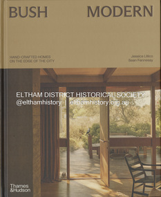 Eltham District Historical Society Inc
Book, Jessica Lillico, Bush Modern: Hand-crafted homes on the edge of the city, 4 Nov. 2025
... Contents: Bush modern locations (map) Grounded in simplicity by Jessica Lillico and Sean Fennessy Time and place by Morag Fraser Houses featured - Stonygrad 1940, North Warrandyte Fraser-Jackson House 1947/1977, Montmorency Busst House 1948, Eltham Burstall House 1950, Montmorency Wright House II 1960, North Warrandyte Collis House 1966, Eltham Diskin House 1967, Eltham Redfern House 1967, North Warrandyte River Bend 1968/2022, Garambi Baan, Eltham Fisher House 1969, Warrandyte Borrack House 1970, Plenty Valley Fiddlers Elbow 1970, North Warrandyte Light Well House 1972, Donvale Birrarung House 1974, Garambi Baan, Eltham High Noon 1974, North Warrandyte Monty Sibbel 1975/2022, Montmorency Provan House 1976/2021, North Warrandyte Pizzey House 1977, Eltham Pittard House 1978, Eltham Gray House 1980, Eltham Carol Ann House 1989, Bend of Islands Wattle Glen 1999, Wattle Glen Big Hill 2001, Christmas Hills ...Contents: Bush modern locations (map) Grounded in simplicity by Jessica Lillico and Sean Fennessy Time and place by Morag Fraser Houses featured - Stonygrad 1940, North Warrandyte Fraser-Jackson House 1947/1977, Montmorency Busst House 1948, Eltham Burstall House 1950, Montmorency Wright House II 1960, North Warrandyte Collis House 1966, Eltham Diskin House 1967, Eltham Redfern House 1967, North Warrandyte River Bend 1968/2022, Garambi Baan, Eltham Fisher House 1969, Warrandyte Borrack House 1970, Plenty Valley Fiddlers Elbow 1970, North Warrandyte Light Well House 1972, Donvale Birrarung House 1974, Garambi Baan, Eltham High Noon 1974, North Warrandyte Monty Sibbel 1975/2022, Montmorency Provan House 1976/2021, North Warrandyte Pizzey House 1977, Eltham Pittard House 1978, Eltham Gray House 1980, Eltham Carol Ann House 1989, Bend of Islands Wattle Glen 1999, Wattle Glen Big Hill 2001, Christmas Hills Stonygrad Fraser-Jackson House Busst House Burstall House Wright House II Collis House Diskin House Redfern House River Bend Fisher House Borrack House Fiddlers Elbow Light Well House Birrarung House High Noon Monty Sibbel Provan House Pizzey House Pittard House Gray House Carol Ann House Wattle Glen Big Hill Inside front cover in ink: "Enjoy! ...From the publisher Thames & Hudson Australia's website: "In the bushy north-eastern fringe of Melbourne, an enduring, uniquely Australian architectural aesthetic has been quietly gaining recognition. Emerging out of necessity in the post-war years, it reimagined the sleek ideals of modernism through the lens of the local landscape. Simple homes built 'of the land' from mud bricks and recycled timber captured the mood of those searching for an alternative way of life close to nature. The movement gathered momentum in the counter-cultural 1960s and culminated in near-mainstream popularity in the 1970s. After a few decades where brown lost appeal in favour of white-washed minimalism, the style in all its warm, earthy glory is once again being embraced and revived by a new generation Through evocative photography by Sean Fennessy, personal stories and architectural insights, Bush Modern explores the timeless appeal of these character-filled homes: tactile, grounded and deeply in tune with their environment." Contents: Bush modern locations (map) Grounded in simplicity by Jessica Lillico and Sean Fennessy Time and place by Morag Fraser Houses featured - Stonygrad 1940, North Warrandyte Fraser-Jackson House 1947/1977, Montmorency Busst House 1948, Eltham Burstall House 1950, Montmorency Wright House II 1960, North Warrandyte Collis House 1966, Eltham Diskin House 1967, Eltham Redfern House 1967, North Warrandyte River Bend 1968/2022, Garambi Baan, Eltham Fisher House 1969, Warrandyte Borrack House 1970, Plenty Valley Fiddlers Elbow 1970, North Warrandyte Light Well House 1972, Donvale Birrarung House 1974, Garambi Baan, Eltham High Noon 1974, North Warrandyte Monty Sibbel 1975/2022, Montmorency Provan House 1976/2021, North Warrandyte Pizzey House 1977, Eltham Pittard House 1978, Eltham Gray House 1980, Eltham Carol Ann House 1989, Bend of Islands Wattle Glen 1999, Wattle Glen Big Hill 2001, Christmas Hills Inside front cover in ink: "Enjoy! Jess & Sean"stonygrad, fraser-jackson house, busst house, burstall house, wright house ii, collis house, diskin house, redfern house, river bend, fisher house, borrack house, fiddlers elbow, light well house, birrarung house, high noon, monty sibbel, provan house, pizzey house, pittard house, gray house, carol ann house, wattle glen, big hill -
 Greensborough Historical Society
Slide - Photograph, John Ramsdale, Plenty River: Slide 15, 1990s
... Photograph shows the Plenty River with rubbish, including tyre and fallen branch. This part of the River is on the Montmorency - Greensborough border....Greensborough Historical Society 34A Glenauburn Road Lower Plenty Lower Plenty melbourne Photograph shows the Plenty River with rubbish, including tyre and fallen branch. This part of the River is on the Montmorency - Greensborough border. ...Photograph shows the Plenty River with rubbish, including tyre and fallen branch. This part of the River is on the Montmorency - Greensborough border.Part of the John Ramsdale collection of slides and audio visual material.Colour photograph scanned from slide.No maker's marks. No caption on slide.plenty river, pollution -
 Greensborough Historical Society
Slide - Photograph, John Ramsdale, Sprayed blackberries: Slide 18, 1990s
... Photograph shows sprayed and dead blackberries on the bank of the Plenty River; behind factories on Para Road Montmorency....Greensborough Historical Society 34A Glenauburn Road Lower Plenty Lower Plenty melbourne Photograph shows sprayed and dead blackberries on the bank of the Plenty River; behind factories on Para Road Montmorency. Part of the John Ramsdale collection of slides and audio visual material. plenty river weeds blackberries para road montmorency No maker's marks. ...Photograph shows sprayed and dead blackberries on the bank of the Plenty River; behind factories on Para Road Montmorency.Part of the John Ramsdale collection of slides and audio visual material.Colour photograph scanned from slide.No maker's marks. No caption on slide.plenty river, weeds, blackberries, para road montmorency -
 Greensborough Historical Society
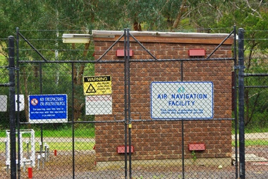
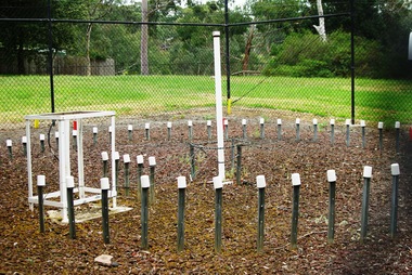
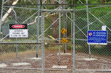
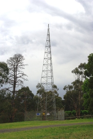
Photograph - Digital Image, Air Navigation Facility, Montmorency, 2018, 1930s
... Air Navigation Facility, Palara Court Montmorency, is made up of a tower and brick building surrounded by wire fences. It is sited in parkland at the end of Palara Court close to the Plenty River Trail. ...Greensborough Historical Society 34A Glenauburn Road Lower Plenty Lower Plenty melbourne Air Navigation Facility, Palara Court Montmorency, is made up of a tower and brick building surrounded by wire fences. It is sited in parkland at the end of Palara Court close to the Plenty River Trail. ...Air Navigation Facility, Palara Court Montmorency, is made up of a tower and brick building surrounded by wire fences. It is sited in parkland at the end of Palara Court close to the Plenty River Trail. Warning signs are placed on the fences, including: "This facility is provided for the control and guidance of aircraft".Digital copy of colour photographair navigation facility, air control, palara court montmorency -
 Greensborough Historical Society
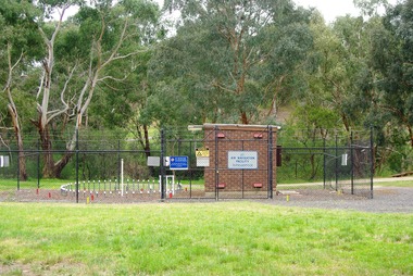
Photograph - Digital Image, Marilyn Smith, Air Navigation Facility, Montmorency, 2018. Long view, 04/12/2018
... Air Navigation Facility, Palara Court Montmorency, is made up of a tower and brick building surrounded by wire fences. It is sited in parkland at the end of Palara Court close to the Plenty River Trail. ...Greensborough Historical Society 34A Glenauburn Road Lower Plenty Lower Plenty melbourne Air Navigation Facility, Palara Court Montmorency, is made up of a tower and brick building surrounded by wire fences. It is sited in parkland at the end of Palara Court close to the Plenty River Trail. ...Air Navigation Facility, Palara Court Montmorency, is made up of a tower and brick building surrounded by wire fences. It is sited in parkland at the end of Palara Court close to the Plenty River Trail. Warning signs are placed on the fences, including: "This facility is provided for the control and guidance of aircraft".Digital copy of colour photographsair navigation facility, air control, palara court montmorency -
 Greensborough Historical Society
Photograph - Digital Image, Marilyn Smith, Air Navigation Facility, Montmorency, 2018. Close up, 04/12/2018
... Air Navigation Facility, Palara Court Montmorency, is made up of a tower and brick building surrounded by wire fences. It is sited in parkland at the end of Palara Court close to the Plenty River Trail. ...Greensborough Historical Society 34A Glenauburn Road Lower Plenty Lower Plenty melbourne Air Navigation Facility, Palara Court Montmorency, is made up of a tower and brick building surrounded by wire fences. It is sited in parkland at the end of Palara Court close to the Plenty River Trail. ...Air Navigation Facility, Palara Court Montmorency, is made up of a tower and brick building surrounded by wire fences. It is sited in parkland at the end of Palara Court close to the Plenty River Trail. Warning signs are placed on the fences, including: "This facility is provided for the control and guidance of aircraft".Digital copy of colour photographair navigation facility, air control, palara court montmorency -
 Greensborough Historical Society
Photograph - Digital Image, Marilyn Smith, Air Navigation Facility, Montmorency, 2018. Signs at tower, 04/12/2018
... Air Navigation Facility, Palara Court Montmorency, is made up of a tower and brick building surrounded by wire fences. It is sited in parkland at the end of Palara Court close to the Plenty River Trail. ...Greensborough Historical Society 34A Glenauburn Road Lower Plenty Lower Plenty melbourne Air Navigation Facility, Palara Court Montmorency, is made up of a tower and brick building surrounded by wire fences. It is sited in parkland at the end of Palara Court close to the Plenty River Trail. ...Air Navigation Facility, Palara Court Montmorency, is made up of a tower and brick building surrounded by wire fences. It is sited in parkland at the end of Palara Court close to the Plenty River Trail. Warning signs are placed on the fences, including: "This facility is provided for the control and guidance of aircraft". This photograph shows signs at tower.Digital copy of colour photographair navigation facility, air control, palara court montmorency -
 Greensborough Historical Society
Photograph - Digital Image, Marilyn Smith, Air Navigation Facility, Montmorency, 2018. Tower, 04/12/2018
... Air Navigation Facility, Palara Court Montmorency, is made up of a tower and brick building surrounded by wire fences. It is sited in parkland at the end of Palara Court close to the Plenty River Trail. ...Greensborough Historical Society 34A Glenauburn Road Lower Plenty Lower Plenty melbourne Air Navigation Facility, Palara Court Montmorency, is made up of a tower and brick building surrounded by wire fences. It is sited in parkland at the end of Palara Court close to the Plenty River Trail. ...Air Navigation Facility, Palara Court Montmorency, is made up of a tower and brick building surrounded by wire fences. It is sited in parkland at the end of Palara Court close to the Plenty River Trail. Warning signs are placed on the fences, including: "This facility is provided for the control and guidance of aircraft". This photograph shows the tower on the site.Digital copy of colour photographsair navigation facility, air control, palara court montmorency -
 Eltham District Historical Society Inc
Photograph, Plenty River at end of Palara Court, Montmorency, c.September 1966, 1966c
... Eltham District Historical Society Inc 728 Main Rd Eltham melbourne Montmorency, Palara Court, Plenty River Originally located in a Filmpro King Size Prints processing envelope $3.01 Shire of Eltham 9/9/66 and noted as Calrossie Ave area and crossed out Eltham-Yarra Glen Road, Bridge Street to Elsa Court existing conditions mid 1967 Black and white photographic print Plenty River at end of Palara Court, Montmorency, c.September 1966 Photograph Peter Pidgeon ...Black and white photographic printOriginally located in a Filmpro King Size Prints processing envelope $3.01 Shire of Eltham 9/9/66 and noted as Calrossie Ave area and crossed out Eltham-Yarra Glen Road, Bridge Street to Elsa Court existing conditions mid 1967montmorency, palara court, plenty river -
 Eltham District Historical Society Inc
Album - Photograph Album, J.A. McDonald, Bridge and Road Reconstruction Works, Shire of Eltham, 1952-1962
... Jolly Kangaroo Ground Kangaroo Ground-Queenstown Road Kangaroo Ground-St Andrews Road Lilydale Shire Office Long Gully Bridge Long Gully Creek Long Gully Road Long Gully Lower Plenty Bridge Lower Plenty Footbridge Lower Plenty Oval Lower Plenty Road Lower Plenty Main Road Methodist Church Montmorency Mount Pleasant Road New Holland Old Healesville Road Opening Ceremony Oxley Bridge Para Road Paul Creek Bridge Paul Creek Road Paul Krafeznk Pinnacle Lane Plaques Plenty River Trail Plenty River Presbyterian Church Prof Donald Thomson Pryor Street railway crossing Railway Parade Rattray Road Reconstruction works Reichelt Avenue Research (Vic.) ...J.A. McDonald produced this record in the course of his responsibilities as Shire Engineer for Eltham Shire Council.Record of various Shire of Eltham infrastructure works undertaken during the period of 1952-1962 involving bridge and road reconstruction projects, sometimes with Eltham Shire Council Project Reference numbers quoted. It was during this period that a number of significant improvements were made to roads and new bridges constructed within the shire that remain in place as of present day (2022). In many situations, the photos provide a tangible visible record of infrastructure that existed throughout the early days of the Shire. The album was put together by or under the direction of the Shire Engineer, J.A. McDonald.a. gillies, alistair knox park, benchmark studies, bend of islands, blease road, box hill state school, box hill teachers college, box hill tip, bridge construction, bridge street bridge, bridge, brisbane street, brougham steet, bulldozer, cecil street, charis pelling, cherry tree road, city of preston, cr. a. brinkkotter, cr. charis pelling, cranes, cromwell street, diamond creek (creek), diamond street, dixons creek bridge, dixon's creek road, drott, eltham leisure centre, eltham north, eltham police station, eltham, eltham-yarra glen road, f. wood, fitzsimons lane bridge, flat rock road, flood damage, floods, floodwater, footpaths and gutters, ford service garage, g. blair, garden hill, glen park bridge, glenauburn road, grand hotel, haldane road, healesville, healesville-yarra glen road, heidelberg-kinglake road, henley road bridge, henley road, hill property, hurstbridge water scheme, hurstbridge, hurstbridge-arthurs creek road, infrastructure, j. jolly, kangaroo ground, kangaroo ground-queenstown road, kangaroo ground-st andrews road, lilydale shire office, long gully bridge, long gully creek, long gully road, long gully, lower plenty bridge, lower plenty footbridge, lower plenty oval, lower plenty road, lower plenty, main road, methodist church, montmorency, mount pleasant road, new holland, old healesville road, opening ceremony, oxley bridge, para road, paul creek bridge, paul creek road, paul krafeznk, pinnacle lane, plaques, plenty river trail, plenty river, presbyterian church, prof donald thomson, pryor street, railway crossing, railway parade, rattray road, reconstruction works, reichelt avenue, research (vic.), research oval, road construction, rymers corner, shire of eltham, shire of whittlesea, silvan road bridge, silver street bridge, silver street, sir dallas brooks, smedley property, st andrews, steels creek, susan street, tarrawarra, tony carberry, uniting church, upper yarra dam, upper yarra reservoir, w.e. wolf, waterfall property, watsons creek, wattletree road bridge, wattletree road, wattletree road bridge, worlingworth, yarra glen, york street, yow yow creek -
 Eltham District Historical Society Inc
Slide - Photograph, Main Yarra Trail, Lower Plenty, c.Aug. 1990
... Montmorency to the mountain roads of Kinglake. In the byways category are views of some iof the Shire's bicycle paths including then recently completed sections of the Main Yarra Trail at Lower Plenty. infrastructure bonds road lower plenty main yarra trail roads Yarra River 35mm colour positive transparency (1 of 37) Mount - Agfachrome Agfa CS System black 8 dots Main Yarra Trail, Lower Plenty Slide Photograph ...Part of a presentation, "Roads and Byways of the Shire of Eltham", by Russell Yeoman to the 12 September 1990 Society meeting. Slides shown included copies of old photos and recent images ranging from the suburban streets of Eltham and Montmorency to the mountain roads of Kinglake. In the byways category are views of some iof the Shire's bicycle paths including then recently completed sections of the Main Yarra Trail at Lower Plenty.35mm colour positive transparency (1 of 37) Mount - Agfachrome Agfa CS System black 8 dotsinfrastructure, bonds road, lower plenty, main yarra trail, roads, yarra river -
 Eltham District Historical Society Inc
Slide - Photograph, Main Yarra Trail, Lower Plenty, c.Aug. 1990
... Montmorency to the mountain roads of Kinglake. In the byways category are views of some iof the Shire's bicycle paths including then recently completed sections of the Main Yarra Trail at Lower Plenty. infrastructure bonds road lower plenty main yarra trail roads yarra river 35mm colour positive transparency (1 of 37) Mount - Agfachrome Agfa CS System black 8 dots Main Yarra Trail, Lower Plenty Slide Photograph ...Part of a presentation, "Roads and Byways of the Shire of Eltham", by Russell Yeoman to the 12 September 1990 Society meeting. Slides shown included copies of old photos and recent images ranging from the suburban streets of Eltham and Montmorency to the mountain roads of Kinglake. In the byways category are views of some iof the Shire's bicycle paths including then recently completed sections of the Main Yarra Trail at Lower Plenty.35mm colour positive transparency (1 of 37) Mount - Agfachrome Agfa CS System black 8 dotsinfrastructure, bonds road, lower plenty, main yarra trail, roads, yarra river -
 Eltham District Historical Society Inc
Slide - Photograph, Aerial Photo (c.1987): Main Road, Lower Plenty from Heidelberg Golf Course to Plenty River, c.Aug. 1990
... Montmorency to the mountain roads of Kinglake. In the byways category are views of some iof the Shire's bicycle paths including then recently completed sections of the Main Yarra Trail at Lower Plenty. infrastructure roads aerial photographs Heidelberg Golf Club Lower Plenty Lower Plenty Bridge Main Road Plenty River 35mm colour positive transparency (1 of 37) Mount - Agfachrome Agfa CS System black 8 dots Aerial Photo (c.1987): Main Road, Lower Plenty from Heidelberg Golf Course to Plenty River Slide Photograph ...Part of a presentation, "Roads and Byways of the Shire of Eltham", by Russell Yeoman to the 12 September 1990 Society meeting. Slides shown included copies of old photos and recent images ranging from the suburban streets of Eltham and Montmorency to the mountain roads of Kinglake. In the byways category are views of some iof the Shire's bicycle paths including then recently completed sections of the Main Yarra Trail at Lower Plenty.35mm colour positive transparency (1 of 37) Mount - Agfachrome Agfa CS System black 8 dotsinfrastructure, roads, aerial photographs, heidelberg golf club, lower plenty, lower plenty bridge, main road, plenty river -
 Eltham District Historical Society Inc
Photograph, Para Road, Montmorency, industrial area looking south from Plenty River Bridge on boundary of Shire of Eltham
... Eltham District Historical Society Inc 728 Main Rd Eltham melbourne 02076 montmorency (france) photo album montmorency para road plenty river industry Colour photograph Para Road, Montmorency, industrial area looking south from Plenty River Bridge on boundary of Shire of Eltham Photograph ...Colour photograph02076, montmorency (france) photo album, montmorency, para road, plenty river, industry -
 Eltham District Historical Society Inc
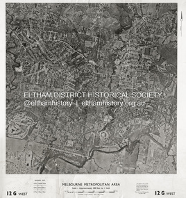
Photograph - Aerial Photograph, Central Plan Office, Eltham, Jan. 1960
... River to south, Andrews Street and Euclyptus Road to east and Greensborough Railway Station to west. Historic Aerial Imagery Source: Central Plan Office Neg. No. 21451 (Print) Dept. of Lands & Survey and the Melb. & Metro. Board of Works. Aerial Photo Details: MELBOURNE METROPOLITAN AREA Section : 12 G West Date : Jan./Feb. 1960 Scale : 800 feet to 1 inch 37°43'18.2"S 145°08'13.0"E Melways : 21 J6 (ed. 42) Aerial Photo Lower Plenty Main Road Montmorency ...Centred on Bolton Street and Brougham Street, Eltham bounded by Progress Road to north, Yarra River to south, Andrews Street and Euclyptus Road to east and Greensborough Railway Station to west. Historic Aerial Imagery Source: Central Plan Office Neg. No. 21451 (Print) Dept. of Lands & Survey and the Melb. & Metro. Board of Works. Aerial Photo Details: MELBOURNE METROPOLITAN AREA Section : 12 G West Date : Jan./Feb. 1960 Scale : 800 feet to 1 inch 37°43'18.2"S 145°08'13.0"E Melways : 21 J6 (ed. 42)aerial photo, lower plenty, main road, montmorency, eltham, eltham lower park, heidelberg golf club, hurstbridge railway line, main road eltham, yarra river, 1960-01, andrews street, arthur street, bolton street, briar hill, brougham steet, dave lyon house, eltham north, eltham-yarra glen road, ernie andrew house, eucalyptus road, greensborough railway station, henry street, karingal road, melway 21j6, montmorency railway station, mount pleasant road, progress road, railway road, southernwood, were street