Showing 30 items matching "poverty mine"
-
 Tarnagulla History Archive
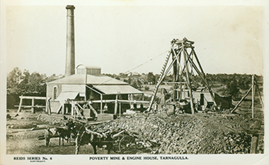
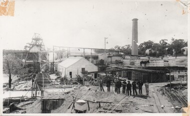
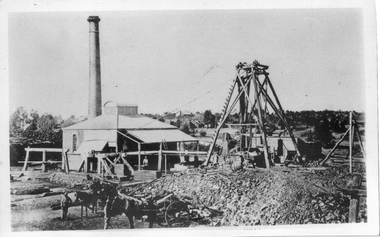
Photographic postcard depicting Poverty Mine & Engine House, Tarnagulla, Poverty Mine & Engine House, Tarnagulla, c. 1940s
... Photographic postcard depicting Poverty Mine & Engine House, Tarnagulla...Poverty Mine & Engine House, Tarnagulla......poverty mine...A monochrome photographic postcard depicting Poverty Mine & Engine House, Tarnagulla. Small building with smokestack and poppethead in middle ground, horses and workers in foreground. ...Tarnagulla History Archive Tarnagulla Public Hall 69-71 Commercial Rd Tarnagulla goldfields Murray Comrie Collection. tarnagulla mining comrie poverty mine Message handwritten on reverse. A monochrome photographic postcard depicting Poverty Mine & Engine House, Tarnagulla. ...Murray Comrie Collection. A monochrome photographic postcard depicting Poverty Mine & Engine House, Tarnagulla. Small building with smokestack and poppethead in middle ground, horses and workers in foreground. From Reid's Series of postcards (No.6). Reverse has a message/letter, appears from be written by Hilda Comrie for Murray Comrie, dated 11/12/1942.Message handwritten on reverse.tarnagulla, mining, comrie, poverty mine -
 Tarnagulla History Archive
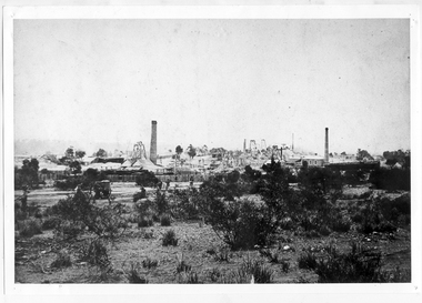
Photograph: View of Poverty Mine, Tarnagulla, circa 1860s
... Photograph: View of Poverty Mine, Tarnagulla......poverty mine...Monochrome photograph depicting view across Tarnagulla showing the Poverty Mine. ...Monochrome photograph depicting view across Tarnagulla showing the Poverty Mine. Photograph: View of Poverty Mine, Tarnagulla ...Murray Comrie Collection. Monochrome photograph depicting view across Tarnagulla showing the Poverty Mine. Written on reverse: 'Poverty Reef Tarnagulla'.tarnagulla, views, poverty mine -
 Tarnagulla History Archive
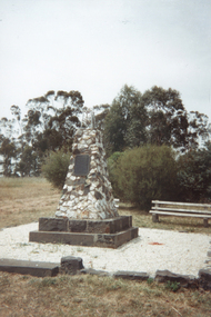
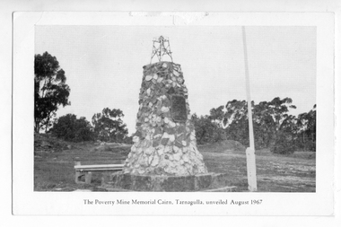
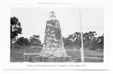
Photograph, Poverty Mine Monument, Tarnagulla, early 1990s
... Poverty Mine Monument, Tarnagulla...A colour photograph depicting the Poverty Mine Monument, Tarnagulla. Original photograph. ...Poverty Mine Monument, Tarnagulla Photograph Photograph ...Donald Clark Collection. A colour photograph depicting the Poverty Mine Monument, Tarnagulla. Original photograph. -
 Tarnagulla History Archive
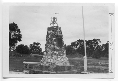
Photograph depicting the Poverty Reef Mine Monument, Tarnagulla, c. 1960s
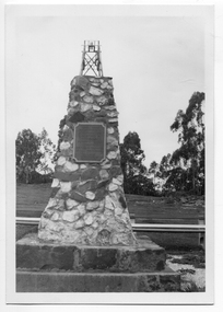
... Photograph depicting the Poverty Reef Mine Monument, Tarnagulla......poverty mine...Sepia photo-postcard depicting the Poverty Reef Mine Monument, Tarnagulla...Sepia photo-postcard depicting the Poverty Reef Mine Monument, Tarnagulla Photograph depicting the Poverty Reef Mine Monument, Tarnagulla ...Murray Comrie Collection. This is an original photograph. Sepia photo-postcard depicting the Poverty Reef Mine Monument, TarnagullaMarked in pen to indicate height of monument.tarnagulla, poverty mine, monuments, king street -
 Tarnagulla History Archive
Photograph depicting the Poverty Reef Mine Monument, Tarnagulla, c. 1960s
... Photograph depicting the Poverty Reef Mine Monument, Tarnagulla......poverty mine...Sepia photo-postcard depicting the Poverty Reef Mine Monument, Tarnagulla...This is an original photograph. tarnagulla poverty mine monuments king street Sepia photo-postcard depicting the Poverty Reef Mine Monument, Tarnagulla Photograph depicting the Poverty Reef Mine Monument, Tarnagulla ...Murray Comrie Collection. This is an original photograph. Sepia photo-postcard depicting the Poverty Reef Mine Monument, Tarnagullatarnagulla, poverty mine, monuments, king street -
 Tarnagulla History Archive
Card: Poverty Mine Monument, Tarnagulla
... Card: Poverty Mine Monument, Tarnagulla...A card printed on one side with image of the Poverty Mine Monument, Tarnagulla and on the other the word 'Greetings'....Card: Poverty Mine Monument, Tarnagulla ...Donald Clark Collection.A card printed on one side with image of the Poverty Mine Monument, Tarnagulla and on the other the word 'Greetings'. -
 Tarnagulla History Archive
Postcard - Photographic postcard: Poverty Mine and Engine House, Tarnagulla, 1911
... Photographic postcard: Poverty Mine and Engine House, Tarnagulla...Front image depicting the Poverty Mine and Engine House, Tarnagulla ...Front image depicting the Poverty Mine and Engine House, Tarnagulla Postcard Photographic postcard: Poverty Mine and Engine House, Tarnagulla ...Williams Family Collection. Photographic postcard, Reids Series No.6. Front image depicting the Poverty Mine and Engine House, Tarnagulla Above information handwritten on reverse.tarnagulla -
 Tarnagulla History Archive
Notice of Public Meeting: Poverty Mine Re-opening, 1987
... Notice of Public Meeting: Poverty Mine Re-opening...A notice for a public meeting about the proposed re-opening of Poverty Mine and associated underground exploration. ...Notice of Public Meeting: Poverty Mine Re-opening ...Donald Clark Collection.A notice for a public meeting about the proposed re-opening of Poverty Mine and associated underground exploration. Held at Victoria Theatre, Tarnagulla on 18th November, 1987. -
 Tarnagulla History Archive
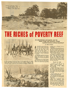
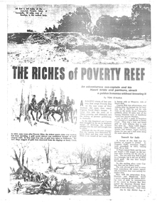
Magazine clipping: 'The Riches of Poverty Reef', The Riches of Poverty Reef, 1964
... ...poverty mine...Pertains to the founding story of Poverty Reef Mine, the origin of its name, founder David Hatt and the shipwreck from which he was saved 'by a Maori princess' whom he later married. ...Tarnagulla History Archive Tarnagulla Public Hall 69-71 Commercial Rd Tarnagulla goldfields Donald Clark Collection. tarnagulla poverty mine gold mining david hatt margaret hatt captain melville carisbrook Clipping from People magazine of July 15, 1964. ...Donald Clark Collection. Clipping from People magazine of July 15, 1964. Article titled 'The Riches of Poverty Reef'. Pertains to the founding story of Poverty Reef Mine, the origin of its name, founder David Hatt and the shipwreck from which he was saved 'by a Maori princess' whom he later married. Also covers bushranging and log lockups. Original, not copy.tarnagulla, poverty mine, gold, mining, david hatt, margaret hatt, captain melville, carisbrook -
 Tarnagulla History Archive
Copy of news clipping: The Riches of Poverty Reef, The Riches of Poverty Reef, July 15, 1964
... ...poverty reef mine...Explains the history of the name of Poverty Reef Mine in Tarnagulla, and stories relating to the mine's operation. ...Explains the history of the name of Poverty Reef Mine in Tarnagulla, and stories relating to the mine's operation. ...Murray Comrie Collection. Photocopy of a page from People magazine, of July 15, 1964 with article titled 'The Riches of Poverty Reef'. Explains the history of the name of Poverty Reef Mine in Tarnagulla, and stories relating to the mine's operation. tarnagulla, poverty reef mine, names -
 Tarnagulla History Archive
Photograph of the Bendigo Consols Mine, Poverty Reef, Tarnagulla, 1898
... Photograph of the Bendigo Consols Mine, Poverty Reef, Tarnagulla, 1898....Tarnagulla History Archive Tarnagulla Public Hall 69-71 Commercial Rd Tarnagulla goldfields Photograph of the Bendigo Consols Mine, Poverty Reef, Tarnagulla, 1898. ... -
Tarnagulla History Archive
News clipping: Tarnagulla Recreation Parks Committee, Tarnagulla CWA, August 7, 1981
... ...poverty mine monument...Tarnagulla History Archive Tarnagulla Public Hall 69-71 Commercial Rd Tarnagulla goldfields Murray Comrie Collection. tarnagulla committees parks recreation reserve tennis courts victoria park poverty mine monument public hall victoria hotel and theatre working bees volunteers volunteering community management A single page of The Advertiser (Maryborough) newspaper of August 7, 1981 with article about formation of the Tarnagulla Recreation Parks Committee and Hall Committee Tarnagulla CWA News clipping: Tarnagulla Recreation Parks Committee ...Murray Comrie Collection. A single page of The Advertiser (Maryborough) newspaper of August 7, 1981 with article about formation of the Tarnagulla Recreation Parks Committee and Hall Committee tarnagulla, committees, parks, recreation reserve, tennis courts, victoria park, poverty mine monument, public hall, victoria hotel and theatre, working bees, volunteers, volunteering, community management -
Tarnagulla History Archive
Newspaper clipping: Resurrecting Derelict Gold Mine Riches, Resurrecting Derelict Gold Mine Riches, 4th November, 1983
... mine...tarnagulla...gold...mining...poverty...Discusses activities at Cambrian Goldmine at Llanelly by Central Victorian Gold Mines NL. Mentions Poverty Reef mine. ...Discusses activities at Cambrian Goldmine at Llanelly by Central Victorian Gold Mines NL. Mentions Poverty Reef mine. Resurrecting Derelict Gold Mine Riches Newspaper clipping: Resurrecting Derelict Gold Mine Riches ...Donald Clark CollectionA clipping from the Bendigo Advertiser newspaper, article with title 'Resurrecting Derelict Gold Mine Riches'. Discusses activities at Cambrian Goldmine at Llanelly by Central Victorian Gold Mines NL. Mentions Poverty Reef mine. llanelly, cambrian gold mine, tarnagulla, gold, mining, poverty reef, reef mining company -
Tarnagulla History Archive
Newspaper article - A Promise Of A Golden Rebirth Rekindles Fire And Hope In The Aging Heartbeat Of The Old Tarnagulla, A Promise Of A Golden Rebirth Rekindles Fire And Hope In The Aging Heartbeat Of The Old Tarnagulla, June 4,1988
... Discusses Western Mining returning to mine Poverty Reef and hopes it will revitalise the town of Tarnagulla. ...Discusses Western Mining returning to mine Poverty Reef and hopes it will revitalise the town of Tarnagulla. ...Don Clark Collection. An article (across two clippings) from the Bendigo Advertiser newspaper of June 4,1988 titled 'A Promise Of A Golden Rebirth Rekindles Fire And Hope In The Aging Heartbeat Of The Old Tarnagulla'. Discusses Western Mining returning to mine Poverty Reef and hopes it will revitalise the town of Tarnagulla. Images of Les Williams, John Lavery, Chris Williams, Don Shipston and Bill Goltz. tarnagulla, mining, western mining, revitalization, people, golden age hotel, lochcarron -
 Bendigo Historical Society Inc.
Newspaper - Newspaper articles by Ken Arnold, Out &About, 2000 - 2003
... Granite Rollers 2.6.00 4. Poverty Mine 9.6.00 5. Golden Monument. St Arnaud 16.6.00 6. ...Granite Rollers 2.6.00 4. Poverty Mine 9.6.00 5. Golden Monument. St Arnaud 16.6.00 6. ...Ken Arnold is a Bendigo author and publisher.A series of one hundred and thirty-five articles written by Ken Arnold and published in the Bendigo Weekly between 2000 and 2003. Each article has a topic or theme and includes historical information and details. Each article includes a photograph. The articles are stored in a red vinyl covered two ring A5 folder. Index below. Number Article Name Date 1. Centenary of Victoria 19.5.00 2. Storm Water Drain 26.5.00 3. Granite Rollers 2.6.00 4. Poverty Mine 9.6.00 5. Golden Monument. St Arnaud 16.6.00 6. Turner Statue 7.7.00 7. Gold Monument. High St Golden Square 30.6.00 8. Gold Monument. Howard Square Bendigo 14.7.00 9. Lansell Statue 21.7.00 10. Shelbourne West School 18.8.00 11. Mologa’s State Schools 25.8.00 12. Salinity Stone. Pyramid Hill 1.9.00 13. Cairn. Carisbrook 8.9.00 14. Commemorative Markers. Taradale 15.9.00 15. Burke Monument. Castlemaine 22.9.00 16. Cairn. Harcourt area 29.9.00 17. Cairn Marks Gold Route 6.10.00 18. Volcanic Rock Cairn. Woodstock 13.10.00 19. Garfield Water Wheel 20.10.00 20. Anticline. Castlemaine 27.10.00 21. Lawson Bridge 10.11.00 22. Plaque. Sutton Grange area 17.11.00 23. Memorial Cairn. Maryborough 1.12.00 24. Lonely Grave 8.12.00 25. Moonlight Flat Church 5.1.01 26. Historic Church. Near Tullaroop reservoir 12.1.01 27. Granite Statue. Castlemaine 19.1.01 28. Marker. Near Tullaroop reservoir 25.1.01 29. Church Site. Mologa 2.2.01 30. Church Site. Mologa 9.2.01 31. Plaque. Mologa 16.2.01 32. Mincha School 23.2.01 33. Historic Marker. Mincha 2.3.01 34. Expedition Marker. Pyramid Hill 9.3.01 35. Irrigation Marker. Tragowel 16.3.01 36. Mologa School Sites 23.3.01 37. Cairn. Pyramid Hill 30.3.01 38. Plaque. Pyramid Hill 6.4.01 39. Bristol Hill Lookout Tower. Maryborough 12.4.01 40. Eppalock Reservoir 20.4.01 41. Colbinabbin Cairn 27.4.01 42. Mount Macedon Cross 4.5.01 43. Memorial Gateway. Macedon 11.5.01 44. Cairn. Daylesford 18.5.01 45. Grave. Carlsruhe 25.5.01 46. Water Tower. Elmore 1.6.01 47. State School Site. Glenalbyn 8.6.01 48. Cairn. Kanya 15.6.01 49. Lonely Grave. Wedderburn 22.6.01 50. Church Cairn. Glenalbyn 29.6.01 51. Kamarooka School 6.7.01 52. Granite Marker. Moyston 13.7.01 53. Memorial Park. Kerang 20.7.01 54. Water Plaque. Bears Lagoon 27.7.01 55. Cemetery. Bears Lagoon 3.8.01 56. Race Monument 10.8.01 57. Cairn. Pyalong 17.8.01 58. Cairn. In memory of Edward Parker 24.8.01 59. Mt Macedon 31.8.01 60. Mt Macedon Cairn 7.9.01 61. Expedition Pass. Chewton 14.9.01 62. Granite Archway. St Arnaud 21.9.01 63. Stuart Mill School Site 28.9.01 64. School Site. Beazley’s Bridge 5.10.01 65. Fosterville 12.10.01 66. Barnadown 19.10.01 67. Salisbury School Site 26.10.01 68. Cricket History at Wattle Flat 2.11.01 69. School Site. Waterloo Plains 9.11.01 70. Carapooee School Site 11.01 71. Turkish Gun. Maldon 11.01 72. Kooreh 30.11.01 73. Marnoo East School 7.12.01 74. Bulgana Site 14.12.01 75. Emu School 21.12.01 76. Kooroocheang 4.1.02 77. Church Site. Gre Gre North 11.1.02 78. Carmens Tunnel. Maldon 18.1.02 79. Monument. Maldon 25.1.02 80. Woodfull Plaques. Maldon 1.2.02 81. Carapooee. St Peters Anglican Church 8.2.02 82. Cairn. Kingower 15.2.02 83. Cob & Co Stopover. Rheola 22.2.02 84. Flynn Monument 1.3.02 85. The Welcome Stranger. Moliagul 8.3.02 86. Campbell’s Creek Reserve 15.3.02 87. Mine. Fryerstown 22.3.02 88. Escott Grave. Near Chewton 28.3.02 89. School No 808. Kurting area 5.4.02 90. Graves. Bendigo Creek 10.5.02 91. School. Fish Point, Benjeroop North 17.5.02 92. Old Township. Diggora 24.5.02 93. Diggora West (1) 31.5.02 94. Diggora West (2) 7.6.02 95. School No 2735. Gower East 14.6.02 96. Pannoomilloo 21.6.02 97. Kamarooka Settlement 28.6.02 98. Mincha West State School No 1931 5.7.02 99. Bridges. Arnold 12.7.02 100. Woodvale 19.7.02 101. A Famous Son of Raywood. Jack Donaldson 26.7.02 102. Tandarra Area Schools 2.8.02 103. Dingee 9.8.02 104. Avonmore 30.8.02 105. Myola East School 6.9.02 106. Colbinabbin West 13.9.02 107. Colbinabbin West School 20.9.02 108. Runnymede area 27.9.02 109. Wanalta 4.10.02 110. School Sites. Between Wanalta and Carop 11.10.02 111. Burramboot 18.10.02 112. Kangaroo Chair. 25.10.02 113. Mincha South 1.11.02 114. Woodlands Church 8.11.02 115. School site. Sylvaterre 15.11.02 116. Terrick Terrick 22.11.02 117. Leitchville 29.11.02 118. Pennyweight Cemetery. Castlemaine 6.12.02 119. Mincha Area 13.12.02 120. Musk School 20.12.02 121. Dowie Park. Carisbrook 3.1.03 122. Neereman School Site 10.1.03 123. Bald Rock 17.1.03 124. Sylvaterre School Site 24.1.02 125. Carlsruhe 31.1.02 126. Athenaeum. Maldon 7.2.03 127. School. Mincha West 14.2.03 128. Yarraberb 21.2.03 129. Settlement Marker. Ravenswood Estate 28.2.03 130. Comini Reserve. Ravenswood 7.3.03 131. Ironbark and Gold Track. Whroo 14.3.03 132. Burke and Wills Obelisk. Castlemaine 21.3.03 133. James Cook Statue. Myers St Bendigo 28.3.03 134. St Marys Church. Axedale 4 .4.03 135. Butter Factory Site. Warragamba 11.4.03 events, monuments, historical sites, landmarks -
 Bendigo Historical Society Inc.
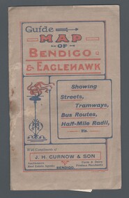
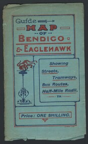
Map - GUIDE MAP OF BENDIGO & EAGLEHAWK, Late 1920's
... Poverty Gully, Sheepshead Gully, Charcoal Gully, Eaglehawk Creek, Bendigo Creek and Back Creek. Contains interesting facts about Bendigo - Area 7,900 acres. Population - 26,000. First Council elected - 1855. Proclaimed a Borough - 1863. Proclaimed a City - 1871. Gold Rush broke out - 1851. For first 10 years gold yield averaged 8,600 ozs. per week . Total gold yield to 1923 - 572 tons valued at 82,000,000 pounds. Deepest mines...Poverty Gully, Sheepshead Gully, Charcoal Gully, Eaglehawk Creek, Bendigo Creek and Back Creek. Contains interesting facts about Bendigo - Area 7,900 acres. Population - 26,000. First Council elected - 1855. Proclaimed a Borough - 1863. Proclaimed a City - 1871. Gold Rush broke out - 1851. For first 10 years gold yield averaged 8,600 ozs. per week . Total gold yield to 1923 - 572 tons valued at 82,000,000 pounds. Deepest mines ...Map. Guide Map of Bendigo & Eaglehawk. Light brown coloured booklet containing folded map of Bendigo and Eaglehawk. Outer cover is printed in blue and red ink and states - With compliments of J H Curnow & Son, Auctioneers, Real Estate Agents, Farm & Dairy Produce Merchants, Bendigo. Printed by J B Young, Lithographer. Map shows tramways & bus routes. Map shows Agricultural Showgrounds located between Park Street, Water Street, Barnard Street and Bridge Lane. Also shows Acclimitization Reserve located behind The Botanical Gardens at White Hills. Shows the location of Sailors Gully, Peg-Leg Gully, Jobs Gully, California Gully, Long Gully, Ironbark Gully, Golden Gully, Poverty Gully, Sheepshead Gully, Charcoal Gully, Eaglehawk Creek, Bendigo Creek and Back Creek. Contains interesting facts about Bendigo - Area 7,900 acres. Population - 26,000. First Council elected - 1855. Proclaimed a Borough - 1863. Proclaimed a City - 1871. Gold Rush broke out - 1851. For first 10 years gold yield averaged 8,600 ozs. per week . Total gold yield to 1923 - 572 tons valued at 82,000,000 pounds. Deepest mines - Victoria Quartz 4,614 ft., New Chum Railway 4,318 ft. 13 mines over 3.000 ft. deep. 53 mines over 2,000 ft. deep. Sewering of City commenced 1922, all principal buildings now sewered. Map printed by Arnall & Jackson, General Printers, Stationers & Engravers, 476 Collins Street. Map displays advertisement for J H Curnow & Son, Bendigo's leading Auctioneer and Estate Agents, Mitchell & Queen Sts. Bendigo. Map Scale 20 chs. = 1 in.cottage, miners, guide map of bendigo and eaglehawk -
 Bendigo Historical Society Inc.
Map - GUIDE MAP OF BENDIGO & EAGLEHAWK, Late 1920's
... Shows the location of Sailors Gully, Peg-Leg Gully, Jobs Gully, California Gully, Long Gully, Ironbark Gully, Golden Gully, Poverty Gully, Sheepshead Gully, Charcoal Gully, Eaglehawk Creek, Bendigo Creek and Back Creek.Contains interesting facts about Bendigo:- Area - 7,900 acres, Population - 26,000, First Council elected - 1855, Proclaimed a City - 1871. Gold Rush broke out - 1851. For first 10 years gold yield averaged 8,600 ozs. Per week. Total gold yield to 1923 - 572 tons valued at 82,000,000 pounds. Deepest mines...Shows the location of Sailors Gully, Peg-Leg Gully, Jobs Gully, California Gully, Long Gully, Ironbark Gully, Golden Gully, Poverty Gully, Sheepshead Gully, Charcoal Gully, Eaglehawk Creek, Bendigo Creek and Back Creek.Contains interesting facts about Bendigo:- Area - 7,900 acres, Population - 26,000, First Council elected - 1855, Proclaimed a City - 1871. Gold Rush broke out - 1851. For first 10 years gold yield averaged 8,600 ozs. Per week. Total gold yield to 1923 - 572 tons valued at 82,000,000 pounds. Deepest mines ...Map. Guide map of Bendigo & Eaglehawk. Folded map of Bendigo & Eaglehawk with blue outer cover booklet. Map is compiled by E E Parker, Eaglehawk. Map shows tramways, bus routes and cost one shilling. Map shows Agricultural Showgrounds located between Park Street, Water Street, Barnard Street and Bridge Lane. Also shows Acclimitization Reserve located behind the Botanical Gardens at White Hills. Shows the location of Sailors Gully, Peg-Leg Gully, Jobs Gully, California Gully, Long Gully, Ironbark Gully, Golden Gully, Poverty Gully, Sheepshead Gully, Charcoal Gully, Eaglehawk Creek, Bendigo Creek and Back Creek.Contains interesting facts about Bendigo:- Area - 7,900 acres, Population - 26,000, First Council elected - 1855, Proclaimed a City - 1871. Gold Rush broke out - 1851. For first 10 years gold yield averaged 8,600 ozs. Per week. Total gold yield to 1923 - 572 tons valued at 82,000,000 pounds. Deepest mines - Victoria Quartz 4,614 ft., New Chum Railway 4,318 ft., 13 mines over 3,000ft. deep, 53 mines over 2,000 ft. deep. Sewering of City commenced 1922. All principal buildings now sewered. Map printed by Arnall & Jackson, General Printers, Stationers & Engravers, 476 Collins Street. Outer map blue cover printed in red and blue ink by J B Young, Lithographer. Map displays advertisement for Bendigo Timber Co. Outer blue cover displays advertisement for Campbell Connelly & Co. Pty. Ltd, Ironmongers, Timware Manufacturers, Plumbers, Sewerage Contractors, High and Forest Sts, Bendigo 9outside back cover) and for Hartleys ( J L Shoosmith) Bendigo, displaying Indian Motor Cycles (inside back cover).map, bendigo, township, guide map of bendigo & eaglehawk -
 Federation University Historical Collection
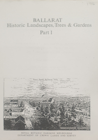
Book, Peter Lumley et al, Ballarat: Historic Landscapes, Trees & Gardens, 1983, 1983
... Barker Library (top floor) Mount Helen goldfields Lisa Green and Lisa Morcom of Ballarat College of Advanced Educatiion contributed to this report. ballarat trees nursery r.u. nicholls francis moss ballarat botanical gardens Victoria Park Lake Wendouree Ballaarat Old Cemetery Eastern Oval Ballarat East Town Hall Gardens Ballarat School of Mines Botanical gardens Eureka Stckade Recreation Reserve Ballarat Observatory Yarrowee Creek Black Hill Reserve Sovereign Hill Ballarat Avenue of Honour Victoria Street plantings Bridge Mall Plantings george longley 275 page landscape study of Ballarat including Trees in the Victorian Landscape; Plant sources early Ballarat nurseries, Botanical Gardens, Lake Wendouree, Fairy Gardens, Victoria Park, Ballaarat Old Cemetery, Eastern Oval, City Oval, Ballarat East Town Hall Gardens, Eureka Stockade, Observatory, Yarrowee, Black Hill, Sovereign Hill, Cheek Channels, Canadian Creek, Poverty Point Reserve, Goldmining Relics, Woah Hawp, Buninyong, street plantings, Russell, Victoria, Bridge Mall, Sturt Street Gardens, Avenue of Honour, Webster, Elms, Ballarat: Historic Landscapes, Trees & Gardens, 1983 Book Book Peter Lumley John Dyke Roger Spencer Eve Almond ...Lisa Green and Lisa Morcom of Ballarat College of Advanced Educatiion contributed to this report.275 page landscape study of Ballarat including Trees in the Victorian Landscape; Plant sources early Ballarat nurseries, Botanical Gardens, Lake Wendouree, Fairy Gardens, Victoria Park, Ballaarat Old Cemetery, Eastern Oval, City Oval, Ballarat East Town Hall Gardens, Eureka Stockade, Observatory, Yarrowee, Black Hill, Sovereign Hill, Cheek Channels, Canadian Creek, Poverty Point Reserve, Goldmining Relics, Woah Hawp, Buninyong, street plantings, Russell, Victoria, Bridge Mall, Sturt Street Gardens, Avenue of Honour, Webster, Elms, ballarat, trees, nursery, r.u. nicholls, francis moss, ballarat botanical gardens, victoria park, lake wendouree, ballaarat old cemetery, eastern oval, ballarat east town hall gardens, ballarat school of mines botanical gardens, eureka stckade recreation reserve, ballarat observatory, yarrowee creek, black hill reserve, sovereign hill, ballarat avenue of honour, victoria street plantings, bridge mall plantings, george longley -
 Federation University Historical Collection
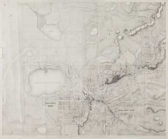
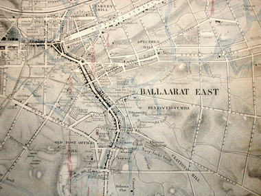
Map, Ballaarat Gold Field, 1861, 1861
... In November 2004 the Central Highlands Regional Library presented a special edition of 200 copies of the 1861 map reproduced from a copy in their collection. ballarat map ballarat east lake wendouree survey mines robert davidson ballarat gold field 1861 yuille's swamp wendouree swamp little bendigo diggings gold leads old post office hill specimen hill bakery hill black hill dead horse creek brown hill pennyweight hill clayton hill soldiers hill golden point gum tree flat white flat poverty hill chinese village robert brough smyth Ballarat map 1861 Ballaarat Vineyard Dead Horse Gully Deadhorse Creek Invermay Black Hill Flat Gaelic Church Police Reserve Magpie Range Dalton's Flat Caadian Lead Rifle Butts Powder Magazine Bathing House Government Camp Gold Office Chinese Llanberrris Victoria Theatre Charlie Napier Hotel United States Hotel Grape's Hoel Clayton's Hill Cattleyard Hill Free Trade Hotel Esmond Lead Bakery Hill Black Hill Lead Juvenile Reformatory Ballarat Orphanage Lady Barkly Lead Triffet's Slaughter Yard Little Bendigo Melbourne Road T. ...A party of surveyors camped by Yuille's Swamp (later Lake Wendouree) and surveyed the countryside for a map to be produced by the Geological Survey of Victoria. In November 2004 the Central Highlands Regional Library presented a special edition of 200 copies of the 1861 map reproduced from a copy in their collection. Original 1861 map of Ballarat showing streets and leads. Blue dots indicate gold leads, and red lines indicate auriferous quartz reef and outcrops of quartz veins."Compiled & Drawn from the Survey of Mining Surveyors Davidson, Fitzpatrick and Cowan & the Plans in the Surveyor General's Office by J. Brahe, 21st October 1861. R. Brough Smyth, Secretary for Mines. The Honourable J.B. Humffray, M.L.A. Commr of Mines.”ballarat, map, ballarat east, lake wendouree, survey, mines, robert davidson, ballarat gold field 1861, yuille's swamp, wendouree swamp, little bendigo diggings, gold leads, old post office hill, specimen hill, bakery hill, black hill, dead horse creek, brown hill, pennyweight hill, clayton hill, soldiers hill, golden point, gum tree flat, white flat, poverty hill, chinese village, robert brough smyth, ballarat map 1861, ballaarat vineyard, dead horse gully, deadhorse creek, invermay, black hill flat, gaelic church, police reserve, magpie range, dalton's flat, caadian lead, rifle butts, powder magazine, bathing house, government camp, gold office, chinese, llanberrris, victoria theatre, charlie napier hotel, united states hotel, grape's hoel, clayton's hill, cattleyard hill, free trade hotel, esmond lead, bakery hill, black hill lead, juvenile reformatory, ballarat orphanage, lady barkly lead, triffet's slaughter yard, little bendigo, melbourne road, t. cowan, thomas cowan -
 Federation University Historical Collection
Map, Ballaarat Gold Field, 1861, 21/10/1861
... In November 2004 the Central Highlands Regional Library presented a special edition of 200 copies of the 1861 map reproduced from a copy in their collection. ballarat map davidson robert brough-smyth fitzpatrick cowan yuille's swamp public garden reserve manure depot black hill ballarat east old post office hill pennyweight hill claytons hill golden point mining railway cricket ground swamp creek cemetery sludge reserve bakery hill gaelic church juvenile reformatory orphanage specimen hill eureka lead cattle yard hill dalton's flat chinese village poverty hill railway reserve little bendigo diggings pound reserve allied armies flour mill agricultural reserve marsh survey reserve survey corps white flat yarrowee yarrowee creek brache j. brache survey ballaarat gold field 1861 Compiled & Drawn from the Survey of Mining Surveyors Davidson, Fitzpatrick and Cowan & the Plans in the Surveyor General's Office by J. Brahe, 21st October 1861. R. Brough Smyth, Secretary for Mines ...A party of surveyors camped by Yuille's Swamp (later Lake Wendouree) and surveyed the countryside for a map to be produced by the Geological Survey of Victoria. In November 2004 the Central Highlands Regional Library presented a special edition of 200 copies of the 1861 map reproduced from a copy in their collection. Original geological map of Ballarat showing property, waterways, mines, churches, schools, water races, and garden reserves. It was compiled and drawn from the surveys of Mining Surveyors Davidson, Fitzpatrick and Cowan.Compiled & Drawn from the Survey of Mining Surveyors Davidson, Fitzpatrick and Cowan & the Plans in the Surveyor General's Office by J. Brahe, 21st October 1861. R. Brough Smyth, Secretary for Mines. The Honourable J.B. Humffray, M.L.A. Commr of Mines.ballarat, map, davidson, robert brough-smyth, fitzpatrick, cowan, yuille's swamp, public garden reserve, manure depot, black hill, ballarat east, old post office hill, pennyweight hill, claytons hill, golden point, mining, railway, cricket ground, swamp creek, cemetery, sludge reserve, bakery hill, gaelic church, juvenile reformatory, orphanage, specimen hill, eureka lead, cattle yard hill, dalton's flat, chinese village, poverty hill, railway reserve, little bendigo diggings, pound reserve, allied armies, flour mill, agricultural reserve, marsh, survey reserve, survey corps, white flat, yarrowee, yarrowee creek, brache, j. brache, survey, ballaarat gold field 1861 -
Federation University Historical Collection
Book, Historic Sites Survey: North Central Study Area, 1979, 1979
... poverty point reserve...union jack reserve buninyong...imperial mine...Barker Library (top floor) Mount Helen goldfields The North Central Study Area included the Shires of Avoca, Bet Bet, east Loddon, Goulburn, Untly, Kara Kara, Korong, Maldon, Marong, Metcalfe, McIvor, Newstead, Strathfieldsaye, Stawell, Talbot, Clunes, Tullaroop and Waranga. castlemaine mount alexander goldfield maldon percydale warrenmang moliagul tarnagulla stuart mill the whipstick whroo rushworth graytown ironbark forest st arnoaud new bendigo landsborough inglewood kurting wedderburn wehla kooroora langham flat mcintyre rheola diamond hill fosterville coliban water works green gully newstead muckleford forest costerfield graytown bailieston waranga irrigaiton system eucalyptus distillery mia mia bridge korokubeal township researce concegella slate quarry chewton fryerstown kingower timor talbot majorca carisbroook clunes st arnaud taradale icomos dunolly limestone castlemaine slate quarry harcourt granite taradale railway viaduct loddon united waterworks trust gouldburn weir carisbrook lock-up history of tree planting in streets history of public reserves r.u. nicholls nurseryman thomas lang francis moss ballarat botanical gardens ballarat school of mines botanical gardens lake wendouree victoria park, ballarat muont holled smith ballaarat old cemetery planting eastern oval ballarat east botanical gardens ballarat east town hall gardens eureka stockade reserve ballarat observatory plantings yarrowee creek plantings yarrowee bluestone channels ballarat woollen mill band and albion mullock heap black hill plantings yarrowee creek channels canadian creek channel specimen vale channel poverty point reserve union jack reserve buninyong imperial mine, buninyong victoria street plantings bridge mall sturt street gardens ballarat avenue of honour plantings white flat oval plantings camp street elms burnt creek 153 page book with white plastic binding. ...The North Central Study Area included the Shires of Avoca, Bet Bet, east Loddon, Goulburn, Untly, Kara Kara, Korong, Maldon, Marong, Metcalfe, McIvor, Newstead, Strathfieldsaye, Stawell, Talbot, Clunes, Tullaroop and Waranga. 153 page book with white plastic binding. It is an historic sites survey for the North Central Study Area commissioned by the Land Conservation Council, the Ministry for COnservation and the Australian Heritage Commission. castlemaine, mount alexander goldfield, maldon, percydale, warrenmang, moliagul, tarnagulla, stuart mill, the whipstick, whroo, rushworth, graytown ironbark forest, st arnoaud, new bendigo, landsborough, inglewood, kurting, wedderburn, wehla, kooroora, langham flat, mcintyre, rheola, diamond hill, fosterville, coliban water works, green gully, newstead, muckleford forest, costerfield, graytown, bailieston, waranga irrigaiton system, eucalyptus distillery, mia mia bridge, korokubeal township researce, concegella slate quarry, chewton, fryerstown, kingower, timor, talbot, majorca, carisbroook, clunes, st arnaud, taradale, icomos, dunolly, limestone, castlemaine slate quarry, harcourt granite, taradale railway viaduct, loddon united waterworks trust, gouldburn weir, carisbrook lock-up, history of tree planting in streets, history of public reserves, r.u. nicholls nurseryman, thomas lang, francis moss, ballarat botanical gardens, ballarat school of mines botanical gardens, lake wendouree, victoria park, ballarat, muont holled smith, ballaarat old cemetery planting, eastern oval, ballarat east botanical gardens, ballarat east town hall gardens, eureka stockade reserve, ballarat observatory plantings, yarrowee creek plantings, yarrowee bluestone channels, ballarat woollen mill, band and albion mullock heap, black hill plantings, yarrowee creek channels, canadian creek channel, specimen vale channel, poverty point reserve, union jack reserve buninyong, imperial mine, buninyong, victoria street plantings, bridge mall, sturt street gardens, ballarat avenue of honour plantings, white flat oval plantings, camp street, elms, burnt creek -
Unions Ballarat
The astonishing history of Ballarat 1851-1855, Bradby, Doug, 2018
... How the Ballarat gold field was discovered by Thomas Hiscock at Buninyong, and by old John Dunlop and young James Regan at Poverty Point, and by Old Tom Brown of Connor’s Party at Golden Point. Chapter 4. The Genesis of Ballarat. How the diggers arrived, mined, lived, and governed themselves at Ballarat. ...How the Ballarat gold field was discovered by Thomas Hiscock at Buninyong, and by old John Dunlop and young James Regan at Poverty Point, and by Old Tom Brown of Connor’s Party at Golden Point. Chapter 4. The Genesis of Ballarat. How the diggers arrived, mined, lived, and governed themselves at Ballarat. ...Chapters Chapter 1. 1848-50. The Discovery of Gold in the Port Phillip District. How a shepherd found Victoria’s first gold but failed to produce a goldrush. Chapter 2. The Discovery of Gold in Victoria. How a publican, a squatter, some more shepherds, a doctor, and an ex mailman, found the gold that produced the Victorian goldrush. Chapter 3. The Discovery of Gold at Ballarat. How the Ballarat gold field was discovered by Thomas Hiscock at Buninyong, and by old John Dunlop and young James Regan at Poverty Point, and by Old Tom Brown of Connor’s Party at Golden Point. Chapter 4. The Genesis of Ballarat. How the diggers arrived, mined, lived, and governed themselves at Ballarat. Chapter 5. The Exodus from Ballarat. Why the diggers left Ballarat when they had found less than 1% of Ballarat’s gold. Chapter 6. The Monster Nuggets. Why Sarah Sands from Ballarat was introduced to Queen Victoria at Windsor Castle. Chapter 7. Settling Down on Ballarat. How and why some diggers settled permanently at Ballarat as miners. Mining in the year of Eureka. How the miners tackled the problems of shepherding and the mining consequences of the Eureka Stockade. Chapter 8. The Gravel Pits. How the miners of Ballarat Flat learnt to work ‘in the water.’ Chapter 9. Towards the Tableland. What the miners did when they hit a ‘wall of rock.’Relevance to the history of Ballarat, gold mining, Sovereign Hill and the Eureka Stockade.Paperback book; 176 pages. Front cover: red background; illustration of miners in white; author's and illustrator's names and title. btlc, ballarat trades and labour council, ballarat trades hall, history - ballarat, history - gold mining, eureka stockade -
 Ballarat Heritage Services
Photograph, Dorothy Wickham, Gold Monument, Ballarat, c2010
... A monument commemorates the centenary of the finding of gold at Poverty Point and is dedicated to the memory of pioneer miners of Ballarat. It record gold yields, nuggets and the richest recorded yields of both alluvial and quartz mines. ...FRONT This monument was erected by the Ballarat Historical Society to commemorate the finding of gold at Poverty Point 21st August 1851 and is dedicated to the memory of/ pioneer miners of Ballarat LEFT SIDE Richest recorded yields alluvial mines Band of Hope 303269 Ozs Prince of Wales 168929 Koh I Noor 164157 Great Redan Ex 110111 Albion 107125 Bonshaw Fr 96520 Park 94699 St George 86702 Sir Wm Don 76830 Hand in Hand 76830 Sir Henry Loch 43562 Quartz Mines Star of the East 256758 Ozs Band of Hope 158299 Victoria United 152013 N Woah Hawp 129562 New Normanby 127562 Britannia 103225 Llanberris No 1 100533 Black Hill 91665 Last Chance U 83766 Llanberris 71364 Speedwell 66000 South Star 64444 Sulieman Pasha Companies 62666 RIGHT Recorded gold yield 20606000 ozs Nuggets Alluvial Welcome 2217 ozs Saraha Snads 1619 Lady Hotham 1177 Canadian 1 1117 Canadian 2 1011 Koh 1 Noor 834 Eureka 625 Lady Loch 617 Prince of Wales 606 Bakery Hill 571 Native Youth 540 Faboulous yields of earliest diggings not offically recorded Quartz Nuggets N Woah Hawp 5-- 300 200 Ozs White Horse 500 Woah Hawp 444 266 262 Canton 257 200 Q Victoria lease 410 U Black Hill Coy 315 Tinworths 250 Parade Coy 245...A monument commemorates the centenary of the finding of gold at Poverty Point and is dedicated to the memory of pioneer miners of Ballarat. It record gold yields, nuggets and the richest recorded yields of both alluvial and quartz mines. ...Gold was discovered in Ballarat in 1851 when many people rushed to the diggings. A monument commemorates the centenary of the finding of gold at Poverty Point and is dedicated to the memory of pioneer miners of Ballarat. It record gold yields, nuggets and the richest recorded yields of both alluvial and quartz mines. The replica gold nugget on the monument is the `Welcome Nugget`, found in Ballarat in 1858, weighed 2,217 ounces and was sold for £10,500. The memorial, known as the Pioneer Miners’ Monument, was made to commemorate Ballarat's gold centenary. It was proposed that part of the Pioneers' Memorial Fund might be used. This fund was started with £1300 profit from the 1938 centenary celebrations. (Age (Melbourne), The monument was created by John Edward Skilbeck, a toolmaker with Ronaldson and Tippett. John Skilbeck had a deep interest in Ballarat History, and undertook much research with Bert Strange and Keith Stacpoole. Councillor William Ernest Roff provided the copper for the memorial from scrap copper obtained during his plumbing business. The copper was reworked by John Skilbeck, and was soldered in the kitchen of his home at 14 Frank Street. Colour photograph of the gold monument on the corner of Sturt Street and Albert Street, Ballarat - also known as the Pioneer Miner's monumwnt. It commemorates the discovery of gold at Poverty Point in August 1851. The quartz structure features a replica of the 62.8 kg Welcome Nugget, the world's largest gold nugget which was found in Ballarat. The monument was unveiled in 1951 and is mainly constructed of large piecesof quartz, with a miniature popper head on the top made of copper. Mounted on the side is a replica of the Welcome Nugget, which was unearthed on the corner of Humffray and Mair Streets, Ballarat on 09 June 1858.FRONT This monument was erected by the Ballarat Historical Society to commemorate the finding of gold at Poverty Point 21st August 1851 and is dedicated to the memory of/ pioneer miners of Ballarat LEFT SIDE Richest recorded yields alluvial mines Band of Hope 303269 Ozs Prince of Wales 168929 Koh I Noor 164157 Great Redan Ex 110111 Albion 107125 Bonshaw Fr 96520 Park 94699 St George 86702 Sir Wm Don 76830 Hand in Hand 76830 Sir Henry Loch 43562 Quartz Mines Star of the East 256758 Ozs Band of Hope 158299 Victoria United 152013 N Woah Hawp 129562 New Normanby 127562 Britannia 103225 Llanberris No 1 100533 Black Hill 91665 Last Chance U 83766 Llanberris 71364 Speedwell 66000 South Star 64444 Sulieman Pasha Companies 62666 RIGHT Recorded gold yield 20606000 ozs Nuggets Alluvial Welcome 2217 ozs Saraha Snads 1619 Lady Hotham 1177 Canadian 1 1117 Canadian 2 1011 Koh 1 Noor 834 Eureka 625 Lady Loch 617 Prince of Wales 606 Bakery Hill 571 Native Youth 540 Faboulous yields of earliest diggings not offically recorded Quartz Nuggets N Woah Hawp 5-- 300 200 Ozs White Horse 500 Woah Hawp 444 266 262 Canton 257 200 Q Victoria lease 410 U Black Hill Coy 315 Tinworths 250 Parade Coy 245gold monument, ballarat, skilbeck, poppet head, j.e. skilbeck, john skilbeck -
 Tarnagulla History Archive
Photograph, Victoria Shaft on Poverty Reef, Tarnagulla, June 1866
... Tarnagulla History Archive Tarnagulla Public Hall 69-71 Commercial Rd Tarnagulla goldfields Donald Clark Collection. mining A monochrome photograph depicting a mine with poppet head at Tarnagulla Copy photograph. Victoria Shaft on Poverty Reef, Tarnagulla, June 1866 Photograph Photograph ...Donald Clark Collection. A monochrome photograph depicting a mine with poppet head at Tarnagulla Copy photograph. mining -
Tarnagulla History Archive
Set of Maps (Mining & Local Area), various
... New Birthday Gold Mine - area map (colour copy) and mine cross-section ( (colour copy). 9. Cross section of Poverty Reef, by Department of Mines (B&W copy, 2 parts on A2 paper) 10. ...New Birthday Gold Mine - area map (colour copy) and mine cross-section ( (colour copy). 9. Cross section of Poverty Reef, by Department of Mines (B&W copy, 2 parts on A2 paper) 10. ...David Gordon Collection. A set of mining documents, maps and plans: 1. Dunolly Deep Leads - showing location and names of deep lead gold deposits in region around Dunolly including at Tarnagulla and Newbridge. Geological Survey of Victoria, Department of Minerals and Energy. Bulletin No. 62, Map No. 4 Dunolly (770 x 485 mm). 2. Poseidon Lead (Facsimile) 3. Nick O Time Lead (Facsimile) 4. Happy Go Lucky Mine prospectus and plan (colour copy) 5. Jones Creek GM Co. (Raven & Gourlay's) Waanyarra - Prospectus (colour copy) 6. Poseidon Area Plan (colour copy) and Poseidon Area map (B&W copy). 7. Cross-section diagram of Spread Eagle Reef 8. New Birthday Gold Mine - area map (colour copy) and mine cross-section ( (colour copy). 9. Cross section of Poverty Reef, by Department of Mines (B&W copy, 2 parts on A2 paper) 10. Time-Lease Graph for Watts Reef, Specimen Reef, Stony Reef, Poverty Reef (second page in detail), created by Eric WIlkinson for Ref Mining NL, 1995 11. 1859 Plan of the Gold Workings & Township of Sandy Creek, Shewing the Mining Leases, Extended Claims & Machinery by R.J. McMillan, Mining Surveyor (B&W copy) 12. Longitundinal and Transverse Vertical Sections of Poverty Reef, Sandy Creek 1859, by R.J. McMillan, Mining Surveyor (B&W copy) 13. Tarnagulla Locality Plan (B&W copy) 14. Universal Grid Reference Map (Topographic) for Laanecoorie North (2 copies) 15. Universal Grid Reference Map (Topographic) for Inglewood South 16. Poverty Reef, Plan showing shafts and early tenements, created by Eric WIlkinson for Ref Mining NL, 1995 17. Locality Map of mining leases in Tarnagulla 18. Plan and Elevation of part of Poverty Reef, Sandy Creek, showing the claims and positions of the shaft. by R.J. McMillan, Mining Surveyor (Facsimile, composed of taped together components) 19.Plan and Elevation of part of Poverty Reef, Sandy Creek, showing the claims and positions of the shaft. by R.J. McMillan, Mining Surveyor (Facsimile, composed of taped together components) -
Tarnagulla History Archive
Article - News article: That Poverty Reef...Really Isn't, 26th January 1980
... Tarnagulla History Archive Tarnagulla Public Hall 69-71 Commercial Rd Tarnagulla goldfields Williams Family Collection. tarnagulla Newspaper clipping discussing mines around Tarnagulla. Article News article: That Poverty Reef...Really Isn't ...Williams Family Collection. Newspaper clipping discussing mines around Tarnagulla.tarnagulla -
 Tarnagulla History Archive
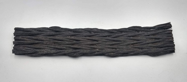
Two sections of Flat Wire Rope used in Tarnagulla mines c.1886
... These are an interested relic from the 1880s when the Prince of Wales and Old Poverty Company converted their winding machinery from flat wire rope to round wire rope. The old rope of some hundreds of metres in length was simply dragged clear of the mine and discarded in the surrounding bushland. ...These are an interested relic from the 1880s when the Prince of Wales and Old Poverty Company converted their winding machinery from flat wire rope to round wire rope. The old rope of some hundreds of metres in length was simply dragged clear of the mine and discarded in the surrounding bushland. ...David Gordon Collection. These are an interested relic from the 1880s when the Prince of Wales and Old Poverty Company converted their winding machinery from flat wire rope to round wire rope. The old rope of some hundreds of metres in length was simply dragged clear of the mine and discarded in the surrounding bushland. This style of rope succeeded the old Indian hemp flat rope, and was in turn superseded by the round wire rope. These segments are most instructive and quite rare relics. The smaller segment measures approximately 40 x 10cm. The longer segment measures approximately 96 by 10cm -
 Tarnagulla History Archive
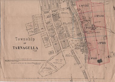
Linen-Backed Map of Tarnagulla Dated 1860 with Updates, Including Mining Leases
... Poverty Reef. The map clarifies details of the mining leases as they stood in 1924, and the map also identifies previously uncertain details such as the location of the battery well, and also the location of the 1909 syndicate to the south of the Sandy Creek Co's shaft. The lightly pencilled location of the Birthday shaft is incorrect. This mine...Poverty Reef. The map clarifies details of the mining leases as they stood in 1924, and the map also identifies previously uncertain details such as the location of the battery well, and also the location of the 1909 syndicate to the south of the Sandy Creek Co's shaft. The lightly pencilled location of the Birthday shaft is incorrect. This mine ...This is a very nice linen-backed map first published in 1860 and progressively updated, the latest being 1924 at the time of Government boring on the Poverty Reef. The map clarifies details of the mining leases as they stood in 1924, and the map also identifies previously uncertain details such as the location of the battery well, and also the location of the 1909 syndicate to the south of the Sandy Creek Co's shaft. The lightly pencilled location of the Birthday shaft is incorrect. This mine was located further to the east. -
 The Beechworth Burke Museum
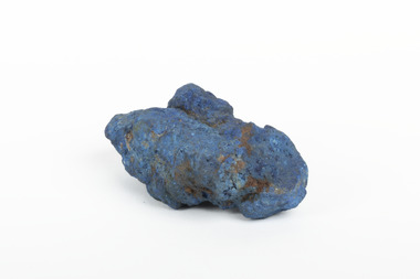
Geological specimen - Azurite, Unknown
... The closure of the mine and the fire left thousands jobless and many people left the area. These were factors in Cobar facing a long stretch of poverty, until a boom in the 1960s led to the reopening of the mine. ...The closure of the mine and the fire left thousands jobless and many people left the area. These were factors in Cobar facing a long stretch of poverty, until a boom in the 1960s led to the reopening of the mine. ...Azurite is a secondary copper mineral made by the weathering of copper sulphide ore deposits. Azurite is formed from copper, carbon, oxygen and hydrogen. There are over 45 forms of azurite that are more well-known, however over 100 forms have been found. Azurite is also commonly found together with Malachite, and Azurite is often psuedomorphed to Malachite. This specimen was found at the Great Cobar Copper Mine in New South Wales, which was founded in 1870. At the time it was one of the largest mining operations in the world. It was the largest copper mine in Australia and housed the southern hemisphere’s tallest chimney stack. The international price of copper collapsed at the end of World War 1 which led to the closure of the Great Cobar Mine on March 16th 1919. A year later on March 10th 1920 an underground fire in the CSA (Cornish, Scottish, Australian) mine started and burned for 16 years. The closure of the mine and the fire left thousands jobless and many people left the area. These were factors in Cobar facing a long stretch of poverty, until a boom in the 1960s led to the reopening of the mine. The mine still operates today, obtained by Metals Acquisition Limited in June 2023. Azurite is considered an uncommon mineral. Named for its deep blue colour, azurite was historically used for pigment making and as a gemstone, despite its softness. This specimen was donated to the Burke Museum between 1868-1880 as part of a larger collection of geological and mineral specimens. Many of the specimens in this collection were obtained as part of the Geological Survey of Victoria, which started in 1852. The Survey aimed to map the scientific makeup of the earth.A solid copper mineral with shades of darker blues almost covering it.burke museum, beechworth, indigo shire, beechworth museum, geological, geological specimen, mineralogy, cobar mines, great cobar copper mine, cobar mining, new south wales, azurite, azurite specimen