Showing 124 items matching "proposed extension"
-
 Port Melbourne Historical & Preservation Society
Drawing - Sketch, Proposed extension of Sandridge Jetty, R R M, 29 Oct 1863
... Sketch, Proposed extension of Sandridge Jetty...Sketch showing proposed extension of Sandridge Jetty 1863....Piers and Wharves - Town Pier Piers and Wharves - Miscellaneous Sketch showing proposed extension of Sandridge Jetty 1863. Drawing Sketch, Proposed extension of Sandridge Jetty R R M ...Sketch showing proposed extension of Sandridge Jetty 1863.piers and wharves - town pier, piers and wharves - miscellaneous -
Stawell Historical Society Inc
Map, Western Mining Corp / Stawell Joint Venture, Aerial Photo of Wonga Open Cut and Tailings Dam No 2 proposed extension, January 1991
... Aerial Photo of Wonga Open Cut and Tailings Dam No 2 proposed extension...Shows proposed extension No2 Tailings Dam off Lavett Road and proposed Revegetation Corridors ...Stawell Historical Society Inc 46 Longfield St Stawell grampians mining gold map Western Mining Corporation Limited Stawell Joint Venture Shows proposed extension No2 Tailings Dam off Lavett Road and proposed Revegetation Corridors Aerial Photo of Wonga Open Cut and Tailings Dam No 2 proposed extension Map Western Mining Corp / Stawell Joint Venture ...Shows proposed extension No2 Tailings Dam off Lavett Road and proposed Revegetation Corridors Western Mining Corporation Limited Stawell Joint Venturemining, gold, map -
University of Melbourne, Burnley Campus Archives
Document, Library - proposed extension, 1970-1975
... Library - proposed extension...Notes justifying expenditure on proposed library extension...University of Melbourne, Burnley Campus Archives 500 Yarra Boulevard Richmond melbourne library extension Notes justifying expenditure on proposed library extension Library - proposed extension Document ...Notes justifying expenditure on proposed library extensionlibrary, extension -
Port Melbourne Historical & Preservation Society
Plan - Proposed extensions, Heath Street, Port Melbourne Town Hall, E J Pembroke, 15 Oct 1936
... Floor plans, elevations to Heath street; south end; roof plan for proposed extensions to supper room Town Hall 1936. ..."City of Port Melbourne . Proposed Extensions to Supper Room . Town Hall"...Coloured plans. Plan Proposed extensions, Heath Street, Port Melbourne Town Hall E J Pembroke ...Floor plans, elevations to Heath street; south end; roof plan for proposed extensions to supper room Town Hall 1936. Coloured plans."City of Port Melbourne . Proposed Extensions to Supper Room . Town Hall"port melbourne town hall, pembroke and turner, e j pembroke -
 Eltham District Historical Society Inc
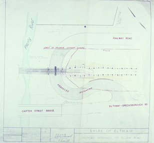
Slide - Photograph, Eltham Shire Council, Proposed extension of Railway Road, Briar Hill, 1969
... Proposed extension of Railway Road, Briar Hill...Eltham District Historical Society Inc 728 Main Rd Eltham melbourne Infrastructure Map planning Subdivison Lots railway road Carter Street Bridge Para Road Para Road Bridge Briar Hill A4, Railway Road intersection, 4 August 1969 35mm colour positive transparency blue Agfacolour Service plastic mount Proposed extension of Railway Road, Briar Hill Slide Photograph Eltham Shire Council ...35mm colour positive transparency blue Agfacolour Service plastic mountA4, Railway Road intersection, 4 August 1969infrastructure, map, planning, subdivison lots, railway road, carter street bridge, para road, para road bridge, briar hill -
 RMIT Design Archives
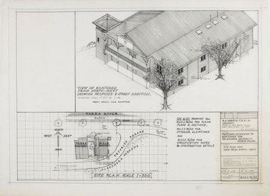
Architectural drawings, Proposed Extension to Boatshed for Melbourne University Sports Union
... Proposed Extension to Boatshed for Melbourne University Sports Union...RMIT Design Archives RMIt University, Building 100 154 Victoria Street Carlton melbourne ink acetate Site Plan and View from North-West Proposed Extension to Boatshed for Melbourne University Sports Union Architectural drawings Harris, Berenice Harris, Berenice ...Site Plan and View from North-Westink, acetate -
 Eltham District Historical Society Inc
Document, Policy and Services reports, PS.038/14 Eltham War Memorial Building Precinct - proposed extension to the Eltham Cenotaph Terrace, Nillumbik Shire Council Policy and Services Committee Meeting, 14 October 2014
... Policy and Services reports, PS.038/14 Eltham War Memorial Building Precinct - proposed extension to the Eltham Cenotaph Terrace, Nillumbik Shire Council Policy and Services Committee Meeting...Relocation of the Eltham Cenotaph following the collapse of the Eltham RSL Sub-Branch eltham cenotaph, eltham war memorial, montmorency-eltham rsl sub-branch, nillumbik shire council 7 A4 pages printed Policy and Services reports, PS.038/14 Eltham War Memorial Building Precinct - proposed extension to the Eltham Cenotaph Terrace, Nillumbik Shire Council Policy and Services Committee Meeting Document Document ...Relocation of the Eltham Cenotaph following the collapse of the Eltham RSL Sub-Branch7 A4 pages printedeltham cenotaph, eltham war memorial, montmorency-eltham rsl sub-branch, nillumbik shire council -
 Melbourne Tram Museum
Drawing, Melbourne & Metropolitan Tramways Board (MMTB), "Explosive Factory Cordite Ave - Proposed Tramway Extension shown red", 1940's
... "Explosive Factory Cordite Ave - Proposed Tramway Extension shown red"...extension to the single track, Maribyrnong tram line to run further into the Explosives Factory. Original print from the Commonwealth of Australia, Dept of Munitions, Factory Board drawing number W-1163 titled "Explosives - Munitions Supply Laboratories Proof at Rest - Maribyrnong" and dated April 1933. Marked in red ink is a "Explosive Factory Cordite Ave - Proposed...Extension shown red". Not dated, possibly early 1940's. Also has pencil markings around the terminus showing an alternative loop. "Explosive Factory Cordite Ave - Proposed ...Drawing - red ink drawn on a print showing an extension to the single track, Maribyrnong tram line to run further into the Explosives Factory. Original print from the Commonwealth of Australia, Dept of Munitions, Factory Board drawing number W-1163 titled "Explosives - Munitions Supply Laboratories Proof at Rest - Maribyrnong" and dated April 1933. Marked in red ink is a "Explosive Factory Cordite Ave - Proposed Tramway Extension shown red". Not dated, possibly early 1940's. Also has pencil markings around the terminus showing an alternative loop.In blue pencil both edges on the rear "Cordite Ave" and in pencil on rear "Copy to Mr ?? to file"trams, tramways, footscray, maribyrnong, new tramway, explosives factory -
 Flagstaff Hill Maritime Museum and Village
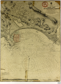
Document - Navigation Chart, Admiralty Office, Lady Bay and Warrnambool Harbour, 1893
... ...proposed extension...These include an additional stamp dated 15-8-1910, a handwritten comment across the top of the page dated August 1910, and another handwritten comment regarding the ‘Proposed Extension of Dock’ dated 19-2-1925, plus connected drawings, notes and figures. ...These include an additional stamp dated 15-8-1910, a handwritten comment across the top of the page dated August 1910, and another handwritten comment regarding the ‘Proposed Extension of Dock’ dated 19-2-1925, plus connected drawings, notes and figures. ...This navigation cart of Lady Bay and Warrnambool Harbour was originally surveyed in 1870 but this version includes the update for magnetic variation in 1893. Since the printing of the chart several annotations have been added. These include an additional stamp dated 15-8-1910, a handwritten comment across the top of the page dated August 1910, and another handwritten comment regarding the ‘Proposed Extension of Dock’ dated 19-2-1925, plus connected drawings, notes and figures. The 1925 proposal on this chart may have been a reaction to the Royal Commission of 1923, when the damaged stonework on the seaward side of the Warrnambool Breakwater, caused by the action of the sea, was the subject of enquiry. A conference between the Public Works, Water Commission and the Harbour Trust concluded that it would less costly to make repairs to prevent further damage rather than replaced the damage portion of the wall. A contract was raised in late 1924 to deposit rubble on the damaged side of the breakwater to minimise the Southern Ocean’s destructive action and work had started by August 1925. The Breakwater construction had begun in 1874 and was completed in 1890. The Victorian Government had commissioned Sir John Coode, a British harbour engineer, to present a plan to complete the Warrnambool Breakwater but his original plan was too expensive. He prepared a revised plan for a shorter structure. The construction proved to be too short to protect adequately from the weather and didn't allow enough depth for larger vessels to come into port. The decreasing trade was further affected by siltation in the bay due to the breakwater, and the completion of the railway line. The situation of the harbour became a real problem by 1910 and required continuous dredging. In 1914 the Breakwater was extended but proved to be a failure because the work began to subside and by 1920 about two thirds of the harbour was silted up. Alterations made in the 1920's increased the silting problem and by the 1940's the harbour was no longer used. More alterations were made in the 1950's and 1960's. This chart is significant for its strong connection to the maritime history of Warrnambool Harbour and Lady Bay and the Warrnambool Breakwater. The Warrnambool Breakwater is registered as a place of significance on the Victorian Heritage Database (VHR H2024). The Warrnambool Breakwater is one of the most important late 19th century maritime engineering projects in Victoria and significant in the development of Victorian coastal shipping. It is also significant for its connection with British harbour engineer, Sir John Coode. The chart is a historical record of structures existing in 1893; the Warrnambool Jetties, Warrnambool Breakwater in Lady Bay, the leading lights (lighthouses), streets, roads, bridges and many buildings. It also shows the lay of the land and seabed. Navigation Chart: Lady Bay and Warrnambool Harbour, Australia - South Coast - Victoria. Surveyed by Nav. Lieut. H.J. Stanley, R.N., 1870. Updated for Magnetic Variation, 1893. The rectangular chart is printed on heavy cream paper. Stamps are shaped rectangular, oval and round. Around the Breakwater and Jetty area are handwritten notes, dotted and joined lines, numbers and signatures, and shading of red and green. The chart shows the surrounds of Warrnambool Harbour, Lady Bay, the Breakwater and Jetty, roads, bridges and the streets in Warrnambool. It has sounding details, and angles of line from the leading lights.Stamp, rectangular, including "AUG 1910" Stamp, double oval " - - - -CHART" Stamp, hand drawn, red circle, with "B" inside Hand written note "22-8-1910 - - - - - of surveying C. Ca - - - request of 15-8-10 [initials] " Notes and lines in red pen, including a grid of sounding numbers: "1300" "1050" "1200" "Possible Extension of Dock" "19-2-25" "Dock Dredged to 20 Ft" Notes and lines in blue pen "Extension of Dock to accommodate vessels drawing 20 Feet" and "Light not visible south of this line" Red dots (4) with yellow highlight at both leading lights, breakwater and jettyflagstaff hill, warrnambool, flagstaff hill maritime museum & village, maritime museum, maritime village, shipwreck coast, map, chart, navigation chart, plan, lady bay, warrnambool harbour, port of warrnambool, breakwater, jetty, pier, dock extension, proposed extension, vhr h2024, 1870, 1893, 1910, 1925, warrnambool town late 1800s, warrnambool streets late 1800s royal commission, 1923, public works, water commission, harbour trust, victorian harbours, sir jon coode -
 Melbourne Tram Museum
Document - Report, "Revision of General Scheme and Special Construction Scheme for Proposed East Burwood Tramway Extension", 1974
... "Revision of General Scheme and Special Construction Scheme for Proposed East Burwood Tramway Extension"...Report - Foolscap bound with black comb binder, 10 pages + two fold out drawings + card covers titled "Revision of General Scheme and Special Construction Scheme for Proposed East Burwood Tramway Extension", not formally dated (1974). ..."Revision of General Scheme and Special Construction Scheme for Proposed East Burwood Tramway Extension" Document Report Melbourne & Metropolitan Tramways Board (MMTB) ...Report - Foolscap bound with black comb binder, 10 pages + two fold out drawings + card covers titled "Revision of General Scheme and Special Construction Scheme for Proposed East Burwood Tramway Extension", not formally dated (1974). Continuing information on the proposal such as route, existing services bus and rail, General Scheme, type of track construction, overhead, costs, fares, resumptions, plans. Includes plans P14604 (shows track arrangement) P14605 general location including the City of Melbourne.trams, tramways, east burwood, new tramways, general scheme, construction -
 Vision Australia
Plan - Image, Proposed additional nurses bedroom to "Myer Home" existing nursery, Blind Institute, St Kilda Rd, 23/8/1949
... 1 architectural plan of Myer House and proposed extension...The south and eastern elevations are detailed, as well as a plan of the nursery, which had 4 bedrooms, a living room, a dinning room , bathroom, 2 kitchen areas and the proposed additional nurses bedroom next to Bedroom 4. royal victorian institute for the blind rvib nursery plans Myer House Percy E Everett, Chief Architect 1 architectural plan of Myer House and proposed extension Proposed additional nurses bedroom to "Myer Home" existing nursery, Blind Institute, St Kilda Rd Plan Image ...In 1949 an architect produced this plan to detail the addition of a bedroom for the nursing staff, who looked after children in the Blind Babies nursery. The plan shows a layout of the RVIB site, including the 'Myers Home' (the name of the nursery) where young children were cared for. The south and eastern elevations are detailed, as well as a plan of the nursery, which had 4 bedrooms, a living room, a dinning room , bathroom, 2 kitchen areas and the proposed additional nurses bedroom next to Bedroom 4.1 architectural plan of Myer House and proposed extensionPercy E Everett, Chief Architectroyal victorian institute for the blind, rvib nursery, plans, myer house -
 Melbourne Tram Museum
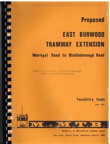
Document - Report, Melbourne & Metropolitan Tramways Board (MMTB), "Proposed East Burwood Tramway Extension - Warragul Road to Middleborough Road - Feasibility Study, Sep. 1974
... "Proposed East Burwood Tramway Extension - Warragul Road to Middleborough Road - Feasibility Study...Titled "Proposed East Burwood Tramway Extension - Warragul Road to Middleborough Road - Feasibility Study June 1974", looks at the purpose of the extension, possible patronage, construction details, costs, existing services and impact on these, proposed services, operating costs, revenue and social benefit - cost analysis. ..."Proposed East Burwood Tramway Extension - Warragul Road to Middleborough Road - Feasibility Study Document Report Melbourne & Metropolitan Tramways Board (MMTB) ...Report - 68 pages, photocopied onto light cartridge paper with brown covers both sides, overlain with clear plastic covers and black comb bound. Titled "Proposed East Burwood Tramway Extension - Warragul Road to Middleborough Road - Feasibility Study June 1974", looks at the purpose of the extension, possible patronage, construction details, costs, existing services and impact on these, proposed services, operating costs, revenue and social benefit - cost analysis. Has many tables, diagrams including fold out map. Showed that the benefit outweighed the costs of the project. Prepared by the MMTB June 1974 - report on front page notes it is Amendment A, September 1974.Stamped "Australian Electric Traction Association Public Transport Committee" on both cover and inside front page.trams, tramways, burwood, east burwood, feasibility study, new tramway, mmtb, middleborough rd -
Whitehorse Historical Society Inc.
Document, Advance Blackburn!, c. 1900
... Circular letter and street plan regarding donations sought to fund a proposed extension of The Avenue to Blackburn Road....Circular letter and street plan regarding donations sought to fund a proposed extension of The Avenue to Blackburn Road. ...Circular letter and street plan regarding donations sought to fund a proposed extension of The Avenue to Blackburn Road.Circular letter and street plan regarding donations sought to fund a proposed extension of The Avenue to Blackburn Road.Circular letter and street plan regarding donations sought to fund a proposed extension of The Avenue to Blackburn Road.blackburn road blackburn, elmore, algernon john, williams, e. g., page, chas. d, the avenue, blackburn -
Kew Historical Society Inc
Archive (Sub-series) - Subject File, Carlton & United Breweries, 1958
... Archive file containing correspondence and planning reports relating to a proposed extension of the Carlton & United Brewery in Abbotsford in 1981-2....Archive file containing correspondence and planning reports relating to a proposed extension of the Carlton & United Brewery in Abbotsford in 1981-2. ...Various partiesReference, Research, InformationSecondary Values (KHS Imposed Order)Subject file containing correspondence and planning reports relating to a proposed extension of the Carlton & United Brewery in Abbotsford in 1981-2.breweries -- melbourne (vic.)breweries -- melbourne (vic.) -
Whitehorse Historical Society Inc.
Article, Bypass Plan Disastrous, 4/12/1991 12:00:00 AM
... Public meeting held to demand that the State Government implement package of alternatives and proposed extension to preserve Koonung and Mullum Mullum Valleys....Public meeting held to demand that the State Government implement package of alternatives and proposed extension to preserve Koonung and Mullum Mullum Valleys. ...Public meeting held to demand that the State Government implement package of alternatives and proposed extension to preserve Koonung and Mullum Mullum Valleys.Public meeting held to demand that the State Government implement package of alternatives and proposed extension to preserve Koonung and Mullum Mullum Valleys.Public meeting held to demand that the State Government implement package of alternatives and proposed extension to preserve Koonung and Mullum Mullum Valleys.freeways, koonung mullum forestway association, public transport users association of victoria, conservation council of victoria, hartwell, ross, spyker, peter -
Whitehorse Historical Society Inc.
Map, Mullauna College, 2015
... Plan of proposed extensions to Mullauna College at an Open Day 21 Jun 2015. ...Plan of proposed extensions to Mullauna College at an Open Day 21 Jun 2015. ...Plan of proposed extensions to Mullauna College at an Open Day 21 Jun 2015.Plan of proposed extensions to Mullauna College at an Open Day 21 Jun 2015. Brand Architects, Wellington Parade, East Melbourne.Plan of proposed extensions to Mullauna College at an Open Day 21 Jun 2015.mullauna secondary college, extensions -
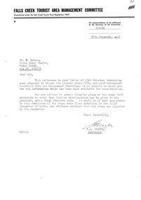 Falls Creek Historical Society
Letter - Proposal To Extend Present Chair Lift
... A letter from the Falls Creek Tourist Area Management Committee requesting detailed plans for the proposed extension of Bob Hymans' chairlift....Chairlift Falls Creek Bob Hymans Falls Creek Tourist Area A letter from the Falls Creek Tourist Area Management Committee requesting detailed plans for the proposed extension of Bob Hymans' chairlift. Proposal To Extend Present Chair Lift. ...Bob Hymans Collection Bob (Herman) Hymans (a former member of the Royal Netherlands Navy was born in Bloemendaal, Holland on 30th September 1922. During World War II he fought against the Japanese in the Dutch East Indies (now Indonesia) and was imprisoned in Changi and on the Burma Railway. After gaining qualifications as a Ski Instructor, Bob arrived in Falls Creek in May 1950. Working as an Instructor and Supervisor at Bogong Lodge, Bob decided his future was in accommodation. He was successful in negotiating an indenture for land from the State Electricity Commission (SEC). It took Bob two years to build his Grande Coeur Chalet but, tragically, it was burned down in August 1961. Bob also built the first Chairlift in Australia. This was a single chairlift and the structure was built from wooden electricity poles. He was constantly full of new ideas and proposals for the village. Bob Hymans died on 7th July 2007. This Collection of documents and letters tells the story of Bob’s endeavours to develop Falls Creek into the ski village it is today.This document is significant because it documents the Bob Hymans' proposals for Falls Creek..A letter from the Falls Creek Tourist Area Management Committee requesting detailed plans for the proposed extension of Bob Hymans' chairlift.chairlift falls creek, bob hymans, falls creek tourist area -
 Bendigo Historical Society Inc.
Document - National Trust Collection: Eaglehawk East Methodist Church, 1980s
... Eaglehawk East Methodist Church Education Department Letters for the re-classification of the church, Data Forms, Photograph, Letters re classification and plans for the use of the church; letters for the proposed extension....History House 11 Mackenzie Street Bendigo goldfields history National Trust Bendigo Collection bendigo Eaglehawk East Methodist Church Eaglehawk East Methodist Church Education Department Letters for the re-classification of the church, Data Forms, Photograph, Letters re classification and plans for the use of the church; letters for the proposed extension. Document National Trust Collection: Eaglehawk East Methodist Church. ...Eaglehawk East Methodist Church Education Department Letters for the re-classification of the church, Data Forms, Photograph, Letters re classification and plans for the use of the church; letters for the proposed extension.history, national trust bendigo collection, bendigo, eaglehawk east methodist church -
Creswick Campus Historical Collection - University of Melbourne
Map, 1923
... Creswick proposed extension, 25-5-1923....Creswick Campus Historical Collection - University of Melbourne 4 Water Street University of Melbourne Creswick Campus Building 719/718 Creswick goldfields Creswick proposed extension, 25-5-1923. Cloth map Map A.E. ...Creswick proposed extension, 25-5-1923.Cloth map -
Port Melbourne Historical & Preservation Society
Map, John Millar, "Design for Ship Canal or 'tidal harbor' and docks for the Port of Melbourne", 21 Sep 1860
... "Design for Ship Canal or 'tidal harbor' and docks for the Port of Melbourne". Shows proposed extension of the city westward. Signed 21.09.1860, lithographed 21.12.1860 and reproduced 1986..."Design for Ship Canal or 'tidal harbor' and docks for the Port of Melbourne". Shows proposed extension of the city westward. Signed 21.09.1860, lithographed 21.12.1860 and reproduced 1986 "Design for Ship Canal or 'tidal harbor' and docks for the Port of Melbourne" Map John Millar Office of Lands and Survey ...COPYRIGHT STATE OF VICTORIA Hydrographic map. "Design for Ship Canal or 'tidal harbor' and docks for the Port of Melbourne". Shows proposed extension of the city westward. Signed 21.09.1860, lithographed 21.12.1860 and reproduced 1986transport - shipping, piers and wharves, engineering - canals and drainage, town planning -
University of Melbourne, Burnley Campus Archives
Plan, Richmond Private Nursing Home, 1979-1996
... Documents relating to Richmond Private Nursing Home. (1) Certificate of Title. (2) Ground Floor Plan. (3) Proposed extensions to existing buildings at 33 Bendigo Street, Richmond (Burgess Associates)....University of Melbourne, Burnley Campus Archives 500 Yarra Boulevard Richmond melbourne nursing home richmond Documents relating to Richmond Private Nursing Home. (1) Certificate of Title. (2) Ground Floor Plan. (3) Proposed extensions to existing buildings at 33 Bendigo Street, Richmond (Burgess Associates). ...Documents relating to Richmond Private Nursing Home. (1) Certificate of Title. (2) Ground Floor Plan. (3) Proposed extensions to existing buildings at 33 Bendigo Street, Richmond (Burgess Associates).nursing home, richmond -
Tatura Irrigation & Wartime Camps Museum
Map, State Rivers and Water Supply Commission, Goulburn Irrigation System, C 1940
... Also indicated by shading are: natural water resources, proposed extensions, existing stock and domestic supply areas, reservoirs, main channels, principal distribution channels, and railways....Also indicated by shading are: natural water resources, proposed extensions, existing stock and domestic supply areas, reservoirs, main channels, principal distribution channels, and railways. ...A map showing the extent of Goulburn irrigation C. 1940. Also indicated by shading are: natural water resources, proposed extensions, existing stock and domestic supply areas, reservoirs, main channels, principal distribution channels, and railways.Irrigation Rivers Victoria.irrigation, victoria state rivers and water supply commission, map -
 Vision Australia
Photograph - Image, Partial demolition of Kelaston Day Centre building for extensions, 1982-83
... Destruction of existing Day Centre building for proposed extensions 081 - Bob Smith and John Wonish, maintenance staff....Destruction of existing Day Centre building for proposed extensions 081 - Bob Smith and John Wonish, maintenance staff. ...Destruction of existing Day Centre building for proposed extensions 081 - Bob Smith and John Wonish, maintenance staff.5 x colour photographs of demolition workkelaston home (ballarat), association for the blind, bob smith, john wonish -
 Whitehorse Historical Society Inc.
Photograph - Coloured photograph, South Parade, Blackburn, 2/08/1979 12:00:00 AM
... Coloured photo of South Parade, Blackburn showing area of proposed railway extensions in 1979...Whitehorse Historical Society Inc. 2-10 Deep Creek Road Mitcham melbourne blackburn railway station South Parade Coloured photo of South Parade, Blackburn showing area of proposed railway extensions in 1979 South Parade, Blackburn Photograph Coloured photograph ...Coloured photo of South Parade, Blackburn showing area of proposed railway extensions in 1979blackburn railway station, south parade -
 Bendigo Historical Society Inc.
Document - MCCOLL, RANKIN AND STANISTREET COLLECTION: RED WHITE & BLUE EXTENDED - CIRCULAR TO SHAREHOLDERS, 1958 - 1962
... Mine description and proposed extensions. Shares application certificate. ...Mine description and proposed extensions. Shares application certificate. ...Document. Light brown folder containing several typewritten copies: re Lease No 9072 originally known as Red White & Blue. Mine description and proposed extensions. Shares application certificate. Folder stamped with South Costerfield Antimony and Gold Mining Company No LiabilityMcColl, Rankin & Stanistreetorganization, business, golden age gold n/l, mccoll, rankin & stanistreet, red white & blue extended, golden age gold n.l, gold mining, share application certificate, lease no.9072 -
 Tarnagulla History Archive
Letter: Railway League to the Mayor of Maryborough, 24th February 1873
... Asks for support of a proposed extension of railway line beyond the exisitng terminus at Dunolly so that it would continue on through Tarnagulla, Newbridge and Woodstock and terminating at Sandhurst (Bendigo), with the purpose of completing a line between Ballarat and Sandhurst (Bendigo)....Asks for support of a proposed extension of railway line beyond the exisitng terminus at Dunolly so that it would continue on through Tarnagulla, Newbridge and Woodstock and terminating at Sandhurst (Bendigo), with the purpose of completing a line between Ballarat and Sandhurst (Bendigo). ...David Gordon Collection. From John Simpson, Secretary of the Sandhurst, Tarnagulla and Dunolly Railway League. Asks for support of a proposed extension of railway line beyond the exisitng terminus at Dunolly so that it would continue on through Tarnagulla, Newbridge and Woodstock and terminating at Sandhurst (Bendigo), with the purpose of completing a line between Ballarat and Sandhurst (Bendigo).railways, transport, trade -
 Melbourne Tram Museum
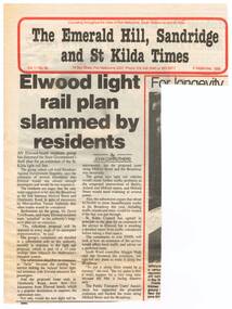
Newspaper, The Emerald Hill, Sandridge and St Kilda Times, "Elwood light rail plan slammed by residents", 8/09/1988 12:00:00 AM
... Newspaper clipping from "The Emerald Hill, Sandridge and St Kilda Times", titled "Elwood light rail plan slammed by residents", 8 September 1988, about the proposed extension of the St Kilda Light rail line into Elwood; the residents using such terms as appalled, ridiculous, futile, traffic problems, though the City of St Kilda was supportive....Melbourne Tram Museum 8 Wallen Road Hawthorn melbourne Trams tramways St Kilda Elwood Light Rail New Tramway Newspaper clipping from "The Emerald Hill, Sandridge and St Kilda Times", titled "Elwood light rail plan slammed by residents", 8 September 1988, about the proposed extension of the St Kilda Light rail line into Elwood; the residents using such terms as appalled, ridiculous, futile, traffic problems, though the City of St Kilda was supportive. ...Newspaper clipping from "The Emerald Hill, Sandridge and St Kilda Times", titled "Elwood light rail plan slammed by residents", 8 September 1988, about the proposed extension of the St Kilda Light rail line into Elwood; the residents using such terms as appalled, ridiculous, futile, traffic problems, though the City of St Kilda was supportive.trams, tramways, st kilda, elwood, light rail, new tramway -
 Melbourne Tram Museum
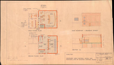
Drawing, Melbourne & Metropolitan Tramways Board (MMTB), "Carlton - Proposed new control room and remodelling of existing control room", May. 1961
... Drawing - titled - "Carlton - Proposed new control room and remodelling of existing control room", coloured with a water colour brush, showing the proposed extensions to the Carlton control room, drawing Number S842, dated 9-5-1961. ...Drawing - titled - "Carlton - Proposed new control room and remodelling of existing control room", coloured with a water colour brush, showing the proposed extensions to the Carlton control room, drawing Number S842, dated 9-5-1961. ...Drawing - titled - "Carlton - Proposed new control room and remodelling of existing control room", coloured with a water colour brush, showing the proposed extensions to the Carlton control room, drawing Number S842, dated 9-5-1961. Shows the ground and first floors, mess room, offices, stairs and control room layout. Has the external elevations and sections.Has some pencil notations front and back re lights and sketch.trams, tramways, carlton, control centre, power supply, electrical engineering, electrical switching -
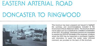 Ringwood and District Historical Society
Newsletter, Eastern Arterial Road Doncaster to Ringwood Environment Effects Statement Summary Brochure - November 1987
... 8-page A4 size brochure issued by Road Construction Authority reporting on the proposed extension of the Eastern Freeway between Doncaster and Ringwood. ...Ringwood and District Historical Society 125A Warrandyte Road Ringwood North melbourne 8-page A4 size brochure issued by Road Construction Authority reporting on the proposed extension of the Eastern Freeway between Doncaster and Ringwood. ...8-page A4 size brochure issued by Road Construction Authority reporting on the proposed extension of the Eastern Freeway between Doncaster and Ringwood. Topics include Community Consultation, Initial Four Lane Development, Estimated Capital Costs, Traffic Effects, Public Transport, Landscape Creek and Visual Aspects, Pedestrian/Bicycle Access, Noise, Air Quality, Lighting, Construction Impacts. -
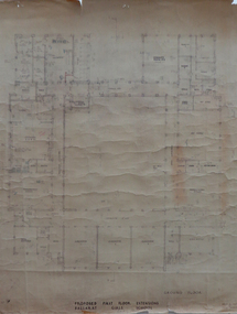 Federation University Historical Collection
Plan, Proposed First Floor Extensions, Ballarat Girls' School, 1957?
... Ink and pencil on paper plan: Proposed First Floor Extension to Ballarat Girls' School ...Barker Library (top floor) Mount Helen goldfields plan percy everett ballarat girls' school Ink and pencil on paper plan: Proposed First Floor Extension to Ballarat Girls' School Proposed First Floor Extensions, Ballarat Girls' School Plan Plan ...Ink and pencil on paper plan: Proposed First Floor Extension to Ballarat Girls' School plan, percy everett, ballarat girls' school