Showing 173 items matching "public facilities"
-
 Ballarat Tramway Museum
Document, State Electricity Commission of Victoria (SECV), "Evidence to be given at the inquiry into Public Transport Facilities at Ballarat", 4/1968
... "Evidence to be given at the inquiry into Public Transport Facilities at Ballarat"...Report, 13 foolscap pages + three attachments stapled on left hand side, titled "Evidence to be given at the inquiry into Public Transport Facilities at Ballarat" Two copies held...."Evidence to be given at the inquiry into Public Transport Facilities at Ballarat" Document State Electricity Commission of Victoria (SECV) ...Details the history of the Ballarat system, take over by the SEC and the conditions of that take over by the SEC, reconstruction, financial losses incurred by the SEC, decline in passengers, its suitability, condition of the infrastructure and rolling stock. Its unsuitability to extend, effectiveness of the Geelong conversion, ability of private bus operators, tramway employees, methods of abandonment, tram tracks, overhead and impact on the electricity supply system. Dated 2/4/1968. Has a table showing the income and losses and population from 1935 to 1967, a coloured graphical presentation of tramway statistics, sheet of Fares and Charges for Ballarat. Attached to the rear of the document was an advertisement for Ballarat Tramways fare sections (See Reg Item 8039) and a map showing tram and bus services - drawing No. VX4/1/1. Attached to the second copy is drawing VD6/144, showing Geelong bus routes and former tram routes. See item 8038 for the Bendigo document dated May 1968. Yield information and demonstrates the SEC's attitude to trams in Ballarat and their finances. Report, 13 foolscap pages + three attachments stapled on left hand side, titled "Evidence to be given at the inquiry into Public Transport Facilities at Ballarat" Two copies held.secv, ballarat, trams, tramways, sec, reports, closure, history, buses, submissions -
 Ballarat Tramway Museum
Document - Report, State Electricity Commission of Victoria (SECV), "Evidence to be given at the inquiry into Public Transport Facilities at Bendigo", May. 1968
... "Evidence to be given at the inquiry into Public Transport Facilities at Bendigo"...Report 15 Foolscap sheets, duplicated and three attachments, was stapled in the top left hand corner, titled "Evidence to be given at the inquiry into Public Transport Facilities at Bendigo" Presented 28/5/1968. ..."Evidence to be given at the inquiry into Public Transport Facilities at Bendigo" Document Report State Electricity Commission of Victoria (SECV) ...Details the history of the Bendigo system, take over by the SEC and the conditions of that take over by the SEC, reconstruction, financial losses incurred by the SEC, decline in passengers, its suitability, condition of the infrastructure and rolling stock. Its unsuitability to extend, effectiveness of the Geelong conversion, ability of private bus operators, tramway employees, methods of abandonment, tram tracks, overhead and impact on the electricity supply system. Has a table showing the income and losses and population from 1935 to 1967, a coloured graphical presentation of tramway statistics, sheet of Fares and Charges for Ballarat. Attached to the rear of the document was an advertisement for Ballarat Tramways fare sections (See Reg Item 8039) See item 9835 for the Ballarat report dated April 1968. At the rear of the second copy is drawing VX4/2/1 showing bus and tram routes in Bendigo and VD6/144A for Geelong. See Reg Item 8046 for a separate map which may have been part of this report.Yield information and demonstrates the SEC's attitude to trams in Bendigo and their finances.Report 15 Foolscap sheets, duplicated and three attachments, was stapled in the top left hand corner, titled "Evidence to be given at the inquiry into Public Transport Facilities at Bendigo" Presented 28/5/1968. Two copies held.trams, tramways, reports, closure, bendigo, history, buses, submissions -
 Ballarat Tramway Museum
Document - Report, City of Ballaarat, "Submission to Enquiry into Public Transport Facilities in the Ballarat Urban District by A. W. Nicholson, Mayor of Ballaarat Council", Apr. 1968
... "Submission to Enquiry into Public Transport Facilities in the Ballarat Urban District by A. ...Report or Submission - 6 Gestener printed foolscap sheets, stapled on left hand side and bound with a blue edging tape titled "Submission to Enquiry into Public Transport Facilities in the Ballarat Urban District by A. ...Document scanned - word searchable. pdf "Submission to Enquiry into Public Transport Facilities in the Ballarat Urban District by A. ...Yields information about the view of the City of Ballaarat in 1968 about the possible replacement of tram service.Report or Submission - 6 Gestener printed foolscap sheets, stapled on left hand side and bound with a blue edging tape titled "Submission to Enquiry into Public Transport Facilities in the Ballarat Urban District by A. W. Nicholson, Mayor of Ballaarat Council". Dated 2 April 1968. Submission looks at the possible closure or the future of the tramway system, the SEC involvement, employment, road surface repairs, financial loss to the SEC, reduction in passengers due to car ownership. Council submitted that the tramway system should be retained and extended and that pensioner concessions should be continued. Notes that at the time 69 men on the trams, 18 at the depot and 8 on the track. If replaced by buses, supported a government owned bus provider rather than private. Document scanned - word searchable. pdftrams, tramways, closure, city of ballaarat, bus replacement, public transport, sec, finances -
Ballarat Tramway Museum
Document - TRB, Transport Regulation Board, "Enquiry into Public Passenger Transport Facilities - Geelong", Sept. 1953
... "Enquiry into Public Passenger Transport Facilities - Geelong"...Document of agenda for the ""Enquiry into Public Passenger Transport Facilities - Geelong Urban District", held Sept - Oct 1953. ..."Enquiry into Public Passenger Transport Facilities - Geelong" Document TRB Transport Regulation Board ...Document of agenda for the ""Enquiry into Public Passenger Transport Facilities - Geelong Urban District", held Sept - Oct 1953. Gives location, and dates, lists organisations represented, and statements of heads of the evidence in Chief by the various bodies, including Councils, SECV, ATOMEA, Trades and Labour, bus operators and other bodies. See also item 9950 for another version.Yields information about the 1953 TRB Enquiry into the closure of Geelong Tramways.Document - 51 quarto pages, pinned in top left hand corner.tramways, trb, enquiries, enquiry, geelong, closure -
 Ballarat Tramway Museum
Document - TRB, Transport Regulation Board, "Enquiry into Public Passenger Transport Facilities - Geelong", Sept. 1953
... "Enquiry into Public Passenger Transport Facilities - Geelong"...Document for the "Enquiry into Public Passenger Transport Facilities - Geelong Urban District", held Sept - Oct 1953. ..."Enquiry into Public Passenger Transport Facilities - Geelong" Document TRB Transport Regulation Board ...Document for the "Enquiry into Public Passenger Transport Facilities - Geelong Urban District", held Sept - Oct 1953. Gives location, and dates, lists organisations represented, and statements of heads of the evidence in Chief by the various bodies, including Councils, SECV, ATOMEA, Trades and Labour, bus operators and other bodies. In the rear, has been inserted the AETA Submssion presented by Mr J Richardson. See also item 9876 for another version.Yields information about the 1953 TRB Enquiry into the closure of Geelong Tramways.Document - 55 foolscap sheets duplicated, plus one quarto sheet taped into the rear cover, with card covers, stapled and tape bound on the left hand side.tramways, trb, enquiries, enquiry, geelong, closure -
 Whitehorse Historical Society Inc.
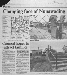
Newspaper - Article, Changing face of Nunawading, 8/09/1993
... The concern is whether sufficient public facilities will be available. Council would oppose any moves to close more schools....The concern is whether sufficient public facilities will be available. Council would oppose any moves to close more schools....The concern is whether sufficient public facilities will be available. Council would oppose any moves to close more schools. ...Article from Nunawading Gazette, 1993, concerning the selling of so many schools in Nunawading and the impact of the increase of population from the extra houses being built.Article from Nunawading Gazette, 1993, concerning the selling of so many schools in Nunawading and the impact of the increase of population from the extra houses being built. The concern is whether sufficient public facilities will be available. Council would oppose any moves to close more schools.Article from Nunawading Gazette, 1993, concerning the selling of so many schools in Nunawading and the impact of the increase of population from the extra houses being built. land subdivision, school buildings, glickman, ray, abbott, kevin, dollis, dimitri, maclellan, robert, middlefield primary school, blackburn technical school, city of nunawading, blackburn south primary school, no. 4035, narmara primary school, burwood east, blackburn east primary school, no. 4800, forest hill secondary college, nunawading campus, heatherdale primary school, warrawong primary school -
 Sunbury Family History and Heritage Society Inc.
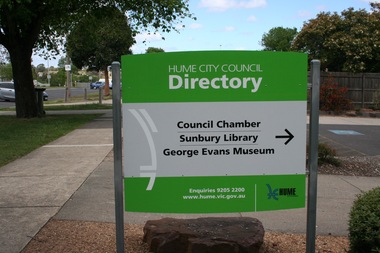
Photograph, Rosa McCall
... A coloured print of a digital photograph of a sign showing directions to public facilities....Signage Sunbury Library Council Offices Macedon Street A coloured print of a digital photograph of a sign showing directions to public facilities. Photograph Rosa McCall ...The sign was erected outside the former Sunbury Council Chambers and the Sunbury Library which also housed the George Evans Museum. These facilities closed in 2017 when Council Administration moved to Broadmeadows and the Sunbury Library was demolished to make way for a more modern facility.A coloured print of a digital photograph of a sign showing directions to public facilities.signage, sunbury library, council offices, macedon street -
 Lakes Entrance Historical Society
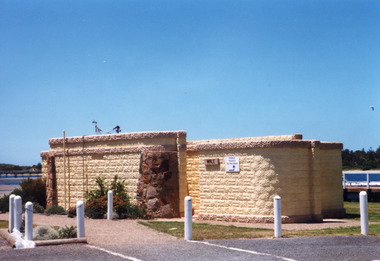
Photograph, Holding M, Eastern wharf public toilet block, Lakes Entrance Victoria, 1998c
... ...Public facilities...Lakes Entrance Historical Society 4 Marine Parade Lakes Entrance gippsland Bricks for toilet block construction were made at Kimmells farm by Clyde Worseldine, Tambo Shire employee after WW2 Jetties Public facilities Colour photograph of the toilet block situated on the eastern wharf precinct, showing a public toilet block constructed of concrete bricks made locally, entrances faced with local stone. ...Bricks for toilet block construction were made at Kimmells farm by Clyde Worseldine, Tambo Shire employee after WW2Colour photograph of the toilet block situated on the eastern wharf precinct, showing a public toilet block constructed of concrete bricks made locally, entrances faced with local stone. Lakes Entrance Victoriajetties, public facilities -
 Falls Creek Historical Society
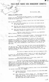
Document - Circular To Licence Holders & Others Interested In Committee Plans
... This included completion of the Gully Chairlift, earmarking sites for cafes and restaurants and improvement in public facilities and medical services....This included completion of the Gully Chairlift, earmarking sites for cafes and restaurants and improvement in public facilities and medical services. Circular To Licence Holders & Others Interested In Committee Plans. ...Bob (Herman) Hymans (a former member of the Royal Netherlands Navy) was born in Bloemendaal, Holland on 30th September 1922. During World War II he fought against the Japanese in the Dutch East Indies (now Indonesia) and was imprisoned in Changi and on the Burma Railway. After gaining qualifications as a Ski Instructor, Bob arrived in Falls Creek in July 1950. Working as an Instructor and Supervisor at Bogong Lodge, Bob decided his future was in accommodation. He was successful in negotiating an indenture for land from the State Electricity Commission (SEC). It took Bob two years to build his Grand Coeur Chalet but, tragically, it was burned down in August 1961. Bob also built the first Chairlift in Australia. This was a single chairlift and the structure was built from wooden electricity poles. He was constantly full of new ideas and proposals for the village. Bob Hymans died on 7th July 2007. This Collection of documents and letters tells the story of Bob's endeavours to develop Falls Creek into the ski village it is today.This letter is significant because it documents developments made or endorsed by the Falls Creek Tourist Area Management Committee.A circular from the Management Committee outlining their plans for the development of the Falls Creek Tourist Area. This included completion of the Gully Chairlift, earmarking sites for cafes and restaurants and improvement in public facilities and medical services.falls creek tourist area management committee, falls creek administration -
 The Beechworth Burke Museum
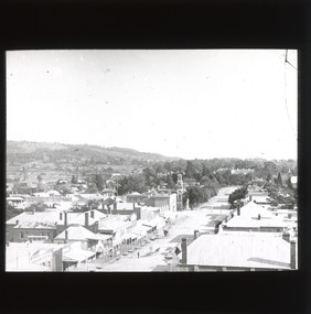
Photograph - Lantern Slide, c1900
... ...shopping facilities...public...Burke Museum Beechworth Lantern Slide Slide Glass Slide Plate Burke Museum Collection Photograph Monochrome ford street christ church of st peter and st paul church tower landmarks 1900 shopping facilities public buildings 1900s built environment streetscape Thin translucent sheet of glass with a square image printed on the front and framed in a black backing. ...This image shows a semi-aerial view of commercial and official properties lining Ford Street, Beechworth, in approximately 1900. The tower of Christ Church of St Peter and St Paul can be seen in the middle section of the photograph, on the left-hand side of the street. The Church was constructed in 1858 with the tower added to the structure in 1864. Lantern slides, sometimes called 'magic lantern' slides, are glass plates on which an image has been secured for the purpose of projection. Glass slides were etched or hand-painted for this purpose from the Eighteenth Century but the process became more popular and accessible to the public with the development of photographic-emulsion slides used with a 'Magic Lantern' device in the mid-Nineteenth Century. Photographic lantern slides comprise a double-negative emulsion layer (forming a positive image) between thin glass plates that are bound together. A number of processes existed to form and bind the emulsion layer to the base plate, including the albumen, wet plate collodion, gelatine dry plate and woodburytype techniques. Lantern slides and magic lantern technologies are seen as foundational precursors to the development of modern photography and film-making techniques.This glass slide is significant because it provides insight into Beechworth's built environment and commercial and official infrastructure in the early Twentieth Century, around the time of Australia's Federation into one nation. It is also an example of an early photographic and film-making technology in use in regional Victoria in the time period.Thin translucent sheet of glass with a square image printed on the front and framed in a black backing. It is held together by metals strips to secure the edges of the slide.burke museum, beechworth, lantern slide, slide, glass slide, plate, burke museum collection, photograph, monochrome, ford street, christ church of st peter and st paul, church tower, landmarks, 1900, shopping facilities, public buildings, 1900s, built environment, streetscape -
 Lakes Entrance Historical Society
Photograph - Public Health, Lakes Post Newspaper, 1990
... Community facilities...Public...Lakes Entrance Historical Society 4 Marine Parade Lakes Entrance gippsland Community facilities Public Health Black and white photograph of community group using facilities at Jemmeson House Community Health Centre for Literacy Education. ...Black and white photograph of community group using facilities at Jemmeson House Community Health Centre for Literacy Education. Lakes Entrance Victoriacommunity facilities, public health -
Warrnambool and District Historical Society Inc.
Book, City of Warrnambool 1961, 1961
... This book has been produced by the Warrnambool City Council and gives details on the activities of the Council in 1961, the public facilities available in the city and the organizations and major industries operating in the City at that time. ...Warrnambool and District Historical Society Inc. 2 Gilles Street (south of Merri St) Warrnambool great-ocean-road This book has been produced by the Warrnambool City Council and gives details on the activities of the Council in 1961, the public facilities available in the city and the organizations and major industries operating in the City at that time. ...This book has been produced by the Warrnambool City Council and gives details on the activities of the Council in 1961, the public facilities available in the city and the organizations and major industries operating in the City at that time. This book is important because it contains valuable historical information about the City of Warrnambool in 1961. This includes the names and contact information on those who were involved in the administration of many clubs and community organizations at that time. The book is also of significance as it belonged to Florence Collins, a noted educator in the city and the first female Warrnambool City Councillor. This is a soft-covered booklet bound with white plastic-covered metal rings in two sections. The pages are not numbered. The cover is cream and it is a little stained and rubbed. There are many black and white photographs. Each page has the city crest at the top of the page. ‘Florence J. Collins’ warrnambool city council, history of warrnambool, florence collins -
 Warrnambool and District Historical Society Inc.
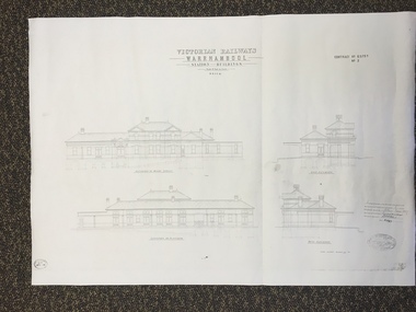
Map, Victorian Railway W'bool No1 & No2, 1897
... It had offices, booking counter and public facilities on the ground floor and housing for the Station Master on the first floor. ...It had offices, booking counter and public facilities on the ground floor and housing for the Station Master on the first floor. ...These two sheets show the 1897 plans drawn up by the Victorian Railways for the erection of the Warrnambool Railway Station building. It is a two-storey building still existing today. The railway came to Warrnambool in 1890 and they must have used temporary buildings for seven years before this railway building was erected. It had offices, booking counter and public facilities on the ground floor and housing for the Station Master on the first floor. The building erected was a typical design for country town railway stations and many of similar design were erected in the 1880s and 90s. These plans are important because they show clearly the design of the Warrnambool Railway Station buildings when they were first erected in the 1890s.They will be very useful for researchers. The coming of the railway was a significant event in Warrnambool’s history and did much to make the port and shipping a less viable proposition.These are two architect’s plans and drawings of the Warrnambool Railway Station building (1897). The drawings are black and white and the first plan shows the ground floor plan and the first floor plan and the outbuildings. The second plan shows drawings of the building with its elevation to the platform and its elevation to Merri Street. There are two stamps of the Railways Department, Melbourne. These are copies, not originals. ‘Victorian Railways, Warrnambool, Station Buildings, Scale 8 feet to one inch, Contract No. 6379B (Nos. 1 and 2)’warrnambool, railway station buildings -
 Bendigo Historical Society Inc.
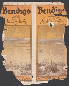
Booklet - Bendigo and the Golden North
... 8537 Booklet presenting the public buildings, churches, recreation facilities, industry and parks and streetscapes of Bendigo in the early 1900s. ...History House 11 Mackenzie Street Bendigo goldfields BHS Collection Golden North Tourist Guide Notable buildings 8537 Booklet presenting the public buildings, churches, recreation facilities, industry and parks and streetscapes of Bendigo in the early 1900s. ...BHS Collection8537 Booklet presenting the public buildings, churches, recreation facilities, industry and parks and streetscapes of Bendigo in the early 1900s. Booklet is presented in B&W with numerous photographs of buildings and streetscapes of the city off Bendigo.golden north, tourist guide, notable buildings -
 Warrnambool and District Historical Society Inc.
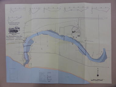
Map - An Angler's map of the Hopkins River Estuary, Angler's map Hopkins River, 1980s
... The information on the sheet includes the location of sand banks, the water depths, boat ramp facilities and public access facilities. Some of the information has been gathered from aerial photographs. ...The information on the sheet includes the location of sand banks, the water depths, boat ramp facilities and public access facilities. Some of the information has been gathered from aerial photographs. ...This is a map of the Hopkins River Estuary prepared by Dr John Sherwood for the benefit of anglers. The information on the sheet includes the location of sand banks, the water depths, boat ramp facilities and public access facilities. Some of the information has been gathered from aerial photographs. The map has been produced by the Warrnambool Institute of Advanced Education which was developed in the late 1960s from the tertiary section of the Warrnambool Technical College and with all its departments established by 1984 at the Sherwood Campus five kilometres from Warrnambool on the Princes Highway. Today the site is occupied by Deakin University, Warrnambool campus. The Warrnambool Anglers’ Club has its headquarters on the banks of the Hopkins River near the mouth of the river and the Lyndoch Aged Care facility.This map is of interest as a specialist one, providing fishermen with detailed information on all aspects of the Hopkins river estuary. Fishing has been both a profession and a popular recreational pursuit for Warrnambool residents since the early days of the city’s settlement. The Hopkins River Estuary has been a focal point for fishermen throughout Warrnambool’s history. This is a sheet of paper folded three times to produce a folded map. The front cover has a black and white photograph of two fishermen with a large fish. The map of the Hopkins River Estuary is in yellow, blue and black and covers the side of one sheet and three quarters of the other side. There is an advertisement for the Hopkins River Boathouse with a black and white sketch of the boathouse and notes on the map written by Dr John Sherwood. There are several diagrams showing the water depths. The map has some silverfish damage and some tearing at the folds. warrnambool anglers’ club, history of warrnambool, hopkins river, hopkins river estuary, john sherwood -
 Ballarat Tramway Museum
Document - Evidence, City of Geelong, "Geelong City Council", 1953
... Evidence or submission by the Geelong City Council for the Enquiry into Public Transport Facilities in the Geelong Urban District" to the Transport Regulation Board, Sept. 1953, presented by Cr B E Purnell. ...Ballarat Tramway Museum South Gardens Reserve Wendouree Parade Ballarat Ballarat goldfields Evidence or submission by the Geelong City Council for the Enquiry into Public Transport Facilities in the Geelong Urban District" to the Transport Regulation Board, Sept. 1953, presented by Cr B E Purnell. ...Evidence or submission by the Geelong City Council for the Enquiry into Public Transport Facilities in the Geelong Urban District" to the Transport Regulation Board, Sept. 1953, presented by Cr B E Purnell. Document addresses issues with buses, trams, railways, hire cars, taxis, Bell Report of 1948 and other matters to be considered. Included is 7 page submission by Geelong and District Town Planning Committee looking at the function of the scheme, relationship with transport authorities, traffic census, transport issues in specific suburbs, road proposals, and town planning.Demonstrates evidence given to the TRB re Geelong transport and town planning in 1953.Document - 10 foolscap sheets, duplicated, stapled in top left hand corner.tramways, tramcars, geelong, history, city of geelong, roads, trb -
 Ringwood and District Historical Society
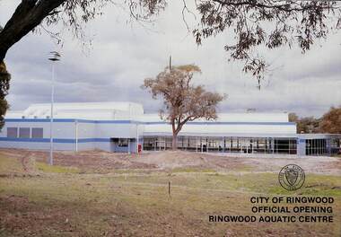
Booklet, City of Ringwood Official Opening Ringwood Aquatic Centre, 1986
... Includes colour photographs and separate double-sided A4 public information brochure advertising facilities and opening hours....Includes colour photographs and separate double-sided A4 public information brochure advertising facilities and opening hours. ...Official Opening Programme of Ringwood Aquatic Centre incorporating the Fred Dwerryhouse Swimming Centre by Cr. Bill Wilkins, J.P., Mayor, on Sunday 27th July, 1986. Includes colour photographs and separate double-sided A4 public information brochure advertising facilities and opening hours.Summary of facility development from Mayor's opening address: These pools were originally built in 1970 and the complex was named in honour of the Town Clerk of Ringwood for many years - Fred Dwerryhouse Swimming Centre. In 1980 the pools were heated and in 1985 Ringwood Council decided to enclose the main pool, install air conditioning, add a diving area, heat the main pool all year, and generally upgrade the entire complex.rinx -
 Ringwood and District Historical Society
Book, City of Ringwood, City of Ringwood 1992 Community Guide, 1992
... Max Williams 1 NEIGHBOURHOOD MAP 26-27 NOTES 52 PAPER & CARDBOARD COLLECTION SERVICE 22 PARKS & RESERVES — PUBLIC FACILITIES 31 PROTECTING OUR COMMUNITY 23-24 PROTECTING THE ENVIRONMENT 20-21 RINGWOOD FESTIVAL & HIGHLAND CARNIVAL 13 RINGWOOD GOLF COURSE 7 STRATEGIC BIKE PLAN 11 STREET INDEX A-L 25 STREET INDEX L-Z 28 THE LIBRARY 12 THE RINGWOOD CONVENTION & PERFORMING ARTS CENTRE 10 TRAFFIC MANAGEMENT 33 YOUR PERSONAL DIRECTORY 50 ...Max Williams 1 NEIGHBOURHOOD MAP 26-27 NOTES 52 PAPER & CARDBOARD COLLECTION SERVICE 22 PARKS & RESERVES — PUBLIC FACILITIES 31 PROTECTING OUR COMMUNITY 23-24 PROTECTING THE ENVIRONMENT 20-21 RINGWOOD FESTIVAL & HIGHLAND CARNIVAL 13 RINGWOOD GOLF COURSE 7 STRATEGIC BIKE PLAN 11 STREET INDEX A-L 25 STREET INDEX L-Z 28 THE LIBRARY 12 THE RINGWOOD CONVENTION & PERFORMING ARTS CENTRE 10 TRAFFIC MANAGEMENT 33 YOUR PERSONAL DIRECTORY 50 Community information book issued by City of Ringwood for 1992 - covering the facilities and activities of the Ringwood Council and other local organisations and associations. ...Community information book issued by City of Ringwood for 1992 - covering the facilities and activities of the Ringwood Council and other local organisations and associations. Includes two Aquatic Centre entry vouchers valid until June 30th, 1992.CONTENTS: (page no.) 1991/92 COUNCIL REPRESENTATIVES 4 1992 CALENDAR 51 AQUATIC CENTRE 8 AQUATIC CENTRE VOUCHERS 49 CHIEF EXECUTIVE'S REPORT 6 CIVIC CENTRE TELEPHONE INDEX — DIRECT DIALLING 53 COMMUNITY DIRECTORY 35-47 COMMUNITY SERVICES 17-19 COUNCIL & COMMITTEE CYCLES 4 COUNCIL FINANCES & 1991/92 RATES 16 COUNCILLORS 3 FUNCTIONAL RESPONSIBILITIES 15 HISTORY OF RINGWOOD 5 HOUSING & RESIDENTIAL DEVELOPMENT 29-30 INFRASTRUCTURE 34 LOCAL, STATE & FEDERAL GOVERNMENT ELECTIONS 32 MANAGEMENT TEAM 14 MAYORAL MESSAGE – Cr. Max Williams 1 NEIGHBOURHOOD MAP 26-27 NOTES 52 PAPER & CARDBOARD COLLECTION SERVICE 22 PARKS & RESERVES — PUBLIC FACILITIES 31 PROTECTING OUR COMMUNITY 23-24 PROTECTING THE ENVIRONMENT 20-21 RINGWOOD FESTIVAL & HIGHLAND CARNIVAL 13 RINGWOOD GOLF COURSE 7 STRATEGIC BIKE PLAN 11 STREET INDEX A-L 25 STREET INDEX L-Z 28 THE LIBRARY 12 THE RINGWOOD CONVENTION & PERFORMING ARTS CENTRE 10 TRAFFIC MANAGEMENT 33 YOUR PERSONAL DIRECTORY 50 rinx -
 Ballarat Tramway Museum
Document - TRB, Transport Regulation Board, "Enquiry into Public Passenger Transport Facilites - Ballarat", April 1968
... Document of agenda for the "Enquiry into Public Passenger Transport Facilities - in the Ballarat Urban District", held April 1968. ...Ballarat Tramway Museum South Gardens Reserve Wendouree Parade Ballarat Ballarat goldfields Document of agenda for the "Enquiry into Public Passenger Transport Facilities - in the Ballarat Urban District", held April 1968. ...Document of agenda for the "Enquiry into Public Passenger Transport Facilities - in the Ballarat Urban District", held April 1968. Gives the terms of reference, location, and dates, lists organisations represented, and statements of heads of the evidence in Chief by the various bodies, including Councils, SECV, ATOMEA, Trades and Labour, Murray Byrne, Chamber of Commerce, Bridge St traders, Davis Motor Services and Wilkins Busways - both by the same person.Yields information about the 1968 TRB Enquiry into the closure of Ballarat Tramways.Document - 22 quarto pages, stapled on left hand edge with blue card covers and blue tape.tramways, trb, enquiries, enquiry, ballarat, closure, davis buses, wilkins busways -
 Warrnambool and District Historical Society Inc.
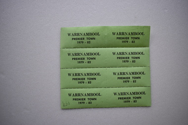
Label, Warrnambool Premier Town, 1979
... The title was awarded by the Premier of Victoria with scores allocated for heritage and environment, community participation, industrial and commercial development, tourism, land use and public works and community facilities. Warrnambool won the inaugural award in 1958, in 1979-82 and in 1988-91....The title was awarded by the Premier of Victoria with scores allocated for heritage and environment, community participation, industrial and commercial development, tourism, land use and public works and community facilities. Warrnambool won the inaugural award in 1958, in 1979-82 and in 1988-91. ...These labels or stickers were produced as part of the celebrations and promotional material to be used during the period 1979 to 1982 when Warrnambool was the official Premier Town in Victoria. The title was awarded by the Premier of Victoria with scores allocated for heritage and environment, community participation, industrial and commercial development, tourism, land use and public works and community facilities. Warrnambool won the inaugural award in 1958, in 1979-82 and in 1988-91.These labels are of minor interest as reminders of one of the times when Warrnambool was awarded the title of Victoria’s Premier Town.These are eight green labels on a perforated sheet. They have black printing and an adhesive backing and are designed to be detached and used separately as stickers or labels.Warrnambool Premier Town 1979-82warrnambool premier town 1979-1982, history of warrnambool, label -
 Melbourne Tram Museum
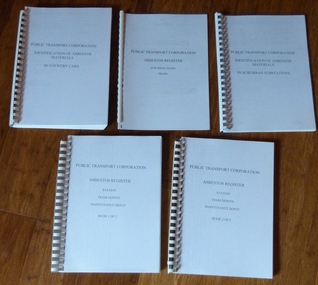
Document - Report, Public Transport Corporation (PTC), "Asbestos Register", c1997
... Set of five reports concerning Asbestos in Public Transport Corporation facilities and rolling stock. ...Melbourne Tram Museum 8 Wallen Road Hawthorn melbourne Trams tramways PTC Asbestos Tram Depot Tramcars Substation Set of five reports concerning Asbestos in Public Transport Corporation facilities and rolling stock. All printed on A4 sheets, bound with white comb binding with clear plastic covers and blue stippled blue rear covers. .1 - "Identification of Asbestos Materials in Suburban Substations" -contains documents dated from 1986 to 1991 listing the work done on substations. ...Set of five reports concerning Asbestos in Public Transport Corporation facilities and rolling stock. All printed on A4 sheets, bound with white comb binding with clear plastic covers and blue stippled blue rear covers. .1 - "Identification of Asbestos Materials in Suburban Substations" -contains documents dated from 1986 to 1991 listing the work done on substations. Approx 50 pages. .2 - "Asbestos Register - Suburban Trains / Trams" - c1992 - approx. 25 pages. .3 - "Identification of Asbestos Materials in Country Cars" - c1990 - approx. 150 pages. .4 - "Asbestos Register - Station, Tram Depots, Maintenance Depot - Book 1 of 2" - 1992-1995, approx. 150 pages. .5 - ditto, book 2 of 2 - 1996 - 1997 - approx. 150 pages.trams, tramways, ptc, asbestos, tram depot, tramcars, substation -
Glen Eira Historical Society
Document - SWIMMING POOLS
... This file contains eight items pertaining to Caulfield’s swimming pools: 1/Report entitled ‘Future Options in the Provision of Public Swimming Facilities in the City of Caulfield’, dated March, 1983, prepared by Caulfield Planning Department of approx. 50 pages. 2/Photocopy of an article from ‘Port Phillip/Caulfield Leader’, dated 11/02/2002, concerning the cost of pool maintenance. 3/Public consultation paper entitled ‘Pools Past, Present and Future’, dated 07/03/2006, prepared by Glen Eira City Council, of 24 pages. 4/Article dated 08/03/2006 from ‘The Age’ concerning Glen Eira Residents’ fight to save swimming pools in Glen Eira. 5/Two page printed leaflet entitled ‘Save Our Pools’ dated 18/03/2006 produced by the northern memorial action group. 6/Three page printed survey sheet entitled ‘The East Bentleigh Swim Centre; an assessment of community needs’ undated, with accompanying return envelope. 7/Front page article from the ‘Glen Eira Caulfield Leader’ dated 04/04/2006 entitled ‘Save Our Pools’. 8/An article from ‘Port Phillip/Caulfield Leader’ dated 04/04/2006, concerning a former Glen Eira Council employee’s information about the Council’s pools report and a ‘letter to the editor’ by Sue Litchfield of Elsternwick containing her view of Glen Eira’s pool requirements....Glen Eira Historical Society 965 Glen Huntly Rd Caulfield VIC 3162 melbourne This file contains eight items pertaining to Caulfield’s swimming pools: 1/Report entitled ‘Future Options in the Provision of Public Swimming Facilities in the City of Caulfield’, dated March, 1983, prepared by Caulfield Planning Department of approx. 50 pages. 2/Photocopy of an article from ‘Port Phillip/Caulfield Leader’, dated 11/02/2002, concerning the cost of pool maintenance. 3/Public consultation paper entitled ‘Pools Past, Present and Future’, dated 07/03/2006, prepared by Glen Eira City Council, of 24 pages. 4/Article dated 08/03/2006 from ‘The Age’ concerning Glen Eira Residents’ fight to save swimming pools in Glen Eira. 5/Two page printed leaflet entitled ‘Save Our Pools’ dated 18/03/2006 produced by the northern memorial action group. 6/Three page printed survey sheet entitled ‘The East Bentleigh Swim Centre; an assessment of community needs’ undated, with accompanying return envelope. 7/Front page article from the ‘Glen Eira Caulfield Leader’ dated 04/04/2006 entitled ‘Save Our Pools’. 8/An article from ‘Port Phillip/Caulfield Leader’ dated 04/04/2006, concerning a former Glen Eira Council employee’s information about the Council’s pools report and a ‘letter to the editor’ by Sue Litchfield of Elsternwick containing her view of Glen Eira’s pool requirements. ...This file contains eight items pertaining to Caulfield’s swimming pools: 1/Report entitled ‘Future Options in the Provision of Public Swimming Facilities in the City of Caulfield’, dated March, 1983, prepared by Caulfield Planning Department of approx. 50 pages. 2/Photocopy of an article from ‘Port Phillip/Caulfield Leader’, dated 11/02/2002, concerning the cost of pool maintenance. 3/Public consultation paper entitled ‘Pools Past, Present and Future’, dated 07/03/2006, prepared by Glen Eira City Council, of 24 pages. 4/Article dated 08/03/2006 from ‘The Age’ concerning Glen Eira Residents’ fight to save swimming pools in Glen Eira. 5/Two page printed leaflet entitled ‘Save Our Pools’ dated 18/03/2006 produced by the northern memorial action group. 6/Three page printed survey sheet entitled ‘The East Bentleigh Swim Centre; an assessment of community needs’ undated, with accompanying return envelope. 7/Front page article from the ‘Glen Eira Caulfield Leader’ dated 04/04/2006 entitled ‘Save Our Pools’. 8/An article from ‘Port Phillip/Caulfield Leader’ dated 04/04/2006, concerning a former Glen Eira Council employee’s information about the Council’s pools report and a ‘letter to the editor’ by Sue Litchfield of Elsternwick containing her view of Glen Eira’s pool requirements.city of caulfield, caulfield, glen eira, caulfield planning department, palmer david, caulfield memorial pool, erlich noel, newton andrew, bentleigh east swim centre, city of glen eira, glen eira town hall, carnegie library, carnegie, shepparson avenue, mckinnon secondary college, east boundary road, koornang road, east bentleigh, feldman david, northern memorial pool, centre road, bentleigh, hudson rob, magee jim, antoine marc, swimming pools, olympic pools, public baths, baths, memorials, local government, northern memorial action group, community groups -
 Flagstaff Hill Maritime Museum and Village
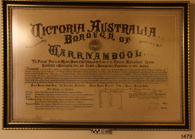
Document - Framed Poster, Borough of Warrnambool, Victoria, Australia, after 30/06/1875
... The writing gives a description of the state of Borough of Warrnambool around 1875; its location, the area it covers, its population, Harbour and facilities, public buildings and institutions, imports and exports, financial worth, number of houses, connection with other areas of the Colony. ...It states geographic location, public buildings and institutions, harbor facilities and imports and exports for the year ending 30th June 1875. ...The writing gives a description of the state of Borough of Warrnambool around 1875; its location, the area it covers, its population, Harbour and facilities, public buildings and institutions, imports and exports, financial worth, number of houses, connection with other areas of the Colony. ...This document, also referred to as a word picture or Tablet, is framed in glass and timber with gilt trim, is handwritten with colour highlights. The penned letters rest on ruled guide lines, decorated where the lines intersect. The writing gives a description of the state of Borough of Warrnambool around 1875; its location, the area it covers, its population, Harbour and facilities, public buildings and institutions, imports and exports, financial worth, number of houses, connection with other areas of the Colony. A possible reason and origin for the document is found in an article ‘Link with US Exhibition’ from the Warrnambool Standard of December 19, 1981, written by local historian Bruce Morris. The writer mentions that the Warrnambool Borough Council met on 15th June 1875 and recorded a letter from G.C. Levey , secretary to the Melbourne group of commissioners representing the Colony, and Victoria in particular, for the Philadelphia Centennial Exhibition of 1876. The letter asks Council to provide “statistics as to the population, social condition and commercial and industrial state of the district in and around Warrnambool.” A sub committee was formed for the project. The Mayor, Cr. Thomas King, wrote and signed a Report, presented to the council on July 14, 1875, in which “The Committee … begs to recommend that a Tablet be prepared setting for the particulars respecting the following matters relating to the Borough”. The matters included area, population, annual income, churches, schools, other public buildings, societies and companies, general description of houses erected, and returns of exports and imports for 1874. The minutes note that the Report was adopted. The article above also notes the opinion of Warrnambool printers who have examined the document; it is almost certainly to be an old lithograph, which means there could be several copies. It is possible that there may be a copy in Melbourne and another in Philadelphia. It is interesting to note that (1) the quoted location co-ordinates are for an “Unnamed Road, Packsaddle NSW 2880, Australia”, and that the DMS co-ordinates for Warrnambool’s Council Offices differ, being 38.23.9.12 South, 142.28.52.887. (2) the date for “Exports and Imports for the Year Ending 30th June 1875” is different to the period mentioned by Cr. King in the sub committee’s Report of recommendation “returns of exports and imports for 1874”. The information required to have the figures for the end of June 1875 would need to have been compiled very quickly for the Tablet to be ready for the opening of the Philadelphia Exhibition on 10 May 1876. The document/certificate shows the following – - - - - - - - - - - - - - - -- - - - - - - - - - - - - - -- - - - - - - - - - - - - - -- - - - - - - - - - - - - - - “Victoria Australia, Borough of Warrnambool. Latitude, 30.24.50 South, Longitude 142.32 East The Principal Port in the Western District of the Colony and the Centre of its Choicest Agricultural Lands. Established a Municipality in 1855, and Created a Borough 1863. Population in 1875 4,500. Warrnambool is the nearest Port to Melbourne on the Western Seaboard, being about 160 miles distant. Coaches run to and from the Metropolis daily, in connexion [connection] with the Railway of Geelong and Steamers belonging to Local Companies sail between Melbourne, Warrnambool, Belfast [renamed Port Fairy], and Portland several times weekly. The Harbour is known as Lady Bay, and is partially protected by a reef of rocks stretching from the mouth of the Hopkins River. The formation of a Breakwater has been decided upon by the Government, to extend 600 yards, at an estimated cost of £100,000. There are two substantial Jetties, one of 800 and the other of 600 feet in length. The former is connected with the Town by means of a Tramroad, along which Goods, inwards & outwards, are conveyed, & the latter has been constructed solely for the purpose of facilitating the transit of material for the formation of the Breakwater. In addition to the trade of the Borough and District, the principal Townships up country receive their supplies from Melbourne and ship their exports through Warrnambool. Potatoes form the staple produce of the district, and the richness of the soil can be estimated by the fact that the Government Statistics for 1875 give as the average yield a return of Seven Tons to the acre. Several thousand acres between Warrnambool and Tower Hill are now being laid down in Potatoes by Tenants who have leased the lands at rates up to £5 per acre for the season 1875-6. Wool, Tallow, hides &c are also largely exported, while the shipments of all descriptions of Farm Produce are annually increasing. Area of Borough, 3362 Acres. Net Annual Value £27,000. Annual Revenue £5,500. Number of Houses in Borough 800. Public Buildings and Institutions Churches. Church of England, Roman Catholic, Presbyterian, Wesleyan, Congregational and Baptist. Schools. Three State Schools, average attendance nearly 1000. New Building in course of erection. Several private establishments. Banks. Bank of Australasia, Bank of Victoria, National Bank, Colonial Bank and Savings Bank. Public Buildings. Court house, Custom house, Post & Telegraph Offices, Survey & Land Offices, Shire £, Town Hall, Mechanics Institute, Volunteer Orderly Room, Odd Fellows Hall, Hospital & Benevolent Asylum, Temperance Hall &c. Companies & Societies. Steam Navigation Co, Woolen Mill Co, Gas Co, Racing Club, Amateur Turf Club, Agricultural Society, Farmers’ Club, Cricket Club, Anglers’ Society, Building Society, Freemasons Odd Fellows, Foresters, Druids, Hibernians. Protestant Alliance, Rechabites, Sons of Temperance, &c, Fire Brigade &c. --- Exports and Imports for the Year Ending 30th June 1875 –-- --Exports Total Tonnage 27,800 (Calculated at the Current Warrnambool Market Prices) Potatoes Wool Wheat Barley Hides Skins Fowls Butter Cheese Eggs Tallow Leather Ale Pigs Sheep Sundries --Imports 13,000 Tons Of the Estimated Value of £520,000 Total Tonnage of Exports and Imports 40m900 Tons, Value £806,627 Passenger Travels, to ad from Warrnambool during year, 10,000 persons Revenue from all sources paid through Warrnambool Sub Treasury From 1860 to June 1875 £1, 292, 300 Thomas King [signed] Mayor Henry T Read [signed] Town Clerk” - - - - - - - - - - - - - - -- - - - - - - - - - - - - - -- - - - - - - - - - - - - - -- - - - - - - - - - - - - - - The document is of historical, social, economic and local significance in that it summarises activities, business, community, trade, travel and government at a point in time in Warrnambool’s history – 30th June 1875.Document, also referred to as a ‘word picture’ or ‘tablet’. Document is framed in glass and timber with gilt trim, handwritten with colour highlights. The penned letters rest on ruled guide lines, decorated where the lines intersect. Document outlines the establishment of Warrnambool as a Municipality in 1855 and Borough in 1863, with a population of 4,500 in 1875. It states geographic location, public buildings and institutions, harbor facilities and imports and exports for the year ending 30th June 1875. Two signatures "Thomas King" Mayor and "Henry T Read" Town Clerk. It shows the Coat of Arms of the Borough of Warrnambool.Signatures - "Thomas King" Mayor and "Henry T Read" Town Clerk. Warrnambool Coat of Arms; “British Coat of Arms, above sailing vessel and sheaf of wheat in sun, motto “By these we flourish” and around circumference “Borough of Warrnambool 1855”flagstaff hill, warrnambool, shipwrecked coast, flagstaff hill maritime museum, maritime museum, shipwreck coast, flagstaff hill maritime village, great ocean road, borough of warrnambool, municipality of warrnambool, document borough of warrnambool 1875, word picture of warrnambool 1875, tablet of borough of warrnambool 1875, statistics borough of warrnambool 1875, lithograph borough of warrnambool 1875, coat of arms warrnambool, warrnambool city motto – in these we flourish, establishment of warrnambool, warrnambool history, thomas king mayor of warrnambool, henry t read town clerk of warrnambool, warrnambool breakwater, warrnambool jetty, warrnambool imports and exports 1875, warrnambool agriculture 1875, warrnambool business 1875, warrnambool population 1875, centennial exhibition philadelphia 1876, framed certificate -
 Warrnambool and District Historical Society Inc.
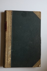
Administrative record - Warrnambool Friendly Societies Park Trust Ledgers, Friendly Societies Park Trust administrative personnel, 1871 to 1947
... This included facilities for cricket, football and Athletics Carnivals and other public demonstrations and meetings and was administered by a Trust with members representing each of the Friendly Societies. ...This included facilities for cricket, football and Athletics Carnivals and other public demonstrations and meetings and was administered by a Trust with members representing each of the Friendly Societies. ...These ledgers are administrative records of the Warrnambool Friendly Societies Park Trust. One contains Minutes of meetings from 1931 to 1947 and the other is an Accounts Book with records of payments for salaries, insurance, rentals, ground improvements etc. from 1908 to 1947. Some inserts in the ledgers date back to the early days of the Trust. In 1871 the Friendly Societies of Warrnambool (benefit societies which mainly offered members heath cover, including the Oddfellows, Foresters, Hibernians,, Rechabites, Sons of Temperance, Druids and Protestant Alliance) established a sports ground in Warrnambool. This included facilities for cricket, football and Athletics Carnivals and other public demonstrations and meetings and was administered by a Trust with members representing each of the Friendly Societies. Today the area is a major sports facility and still has the name Friendly Societies Park but it is now administered by the Warrnambool City Council. These items are of considerable historical interest as they contain much detail about the early history of the Friendly Societies Park Trust and give researchers valuable information on the work of benefit societies in the late 19th and early 20th centuries in Warrnambool and also on a major sports facility still existing in Warrnambool. .1 Ledger of 380 pages with a black cover and beige leather spine and corners. The edges of the pages are marbled and the pages have printed red and blue lines. The handwritten entries are in ink. There are some loose inserts in this ledger. .2 Ledger of 510 pages with a black cover and beige leather spine and corners. The pages have an alphabetical index at the front and have red and blue printed lines. The handwritten entries are in ink. friendly societies park warrnambool, friendly societies in warrnambool -
 Warrnambool and District Historical Society Inc.
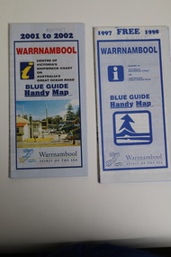
Pamphlet (Collection) - Warrnambool Tourist Maps, Warrnambool City Council, 1975 to 2002
... All have been produced for the benefit of local people and tourists, showing streets in Warrnambool, local amenities and public buildings and businesses and accommodation facilities. Some give additional information on the city and surrounding areas. ...All have been produced for the benefit of local people and tourists, showing streets in Warrnambool, local amenities and public buildings and businesses and accommodation facilities. Some give additional information on the city and surrounding areas. ...Warrnambool Tourist Maps collected over the years by Warrnambool Historical Society membersPreservation of local maps for historical purposesEnclosed in A4 size plastic envelopes in an A4 size archival box and numbered and catalogued according to the date of acquisition.This collection has 16 pamphlets containing maps of Warrnambool and district and some accompanying printed materialwarrnambool tourism, city of warrnambool, shipwreck coast tourismwarrnambool tourism, city of warrnambool, shipwreck coast tourism -
 Warrnambool and District Historical Society Inc.
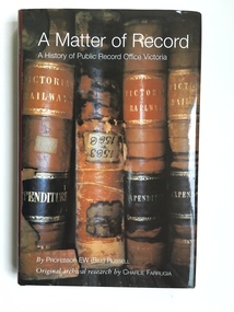
Book, A Matter of Record, 2003
... In addition we are a Place of Deposit for historical records that are surplus to the requirements of the Public Record Office of Victoria and that concern more directly the history of Warrnambool and district. Many local Warrnambool and district residents use the facilities at the Public Record Office at North Melbourne and the link between that institution and Warrnambool historical groups is important. public record office professor bill russell charlie farrugia historical records of victoria Front Cover: ‘A Matter of Record, A History of Public Record Office Victoria by Professor E W (Bill) Russell, Original archival research by Charlie Farrugia.’ ...This book gives the history of the Public Record Office, Victoria. It was written by Professor Bill Russell and produced in 2003. The research by Charlie Farrugia that enabled the book to be written was carried out entirely using the Public Record Office archives. The book documents the 1903 beginnings of the Public Record Office from a small collection in the possession of the Melbourne Public Library through to the important 1973 Victorian Public Records Act to the present day institution at North Melbourne. The Melbourne Public Library, the Historical Society of Victoria and the History School of the University of Melbourne were early contributors to the preservation of Victoria’s archives. This book is in the library of the Warrnambool and District Historical Society and is an important reference for us in regard to the history of archival preservation of historical documents in our State. In addition we are a Place of Deposit for historical records that are surplus to the requirements of the Public Record Office of Victoria and that concern more directly the history of Warrnambool and district. Many local Warrnambool and district residents use the facilities at the Public Record Office at North Melbourne and the link between that institution and Warrnambool historical groups is important. This is a hard cover book of 227 pages. The cover is black with gold lettering on the spine. The dust cover is dark red with printed material about the author and the book’s contents. The front of the dust cover has an illustration of four Victorian Railways ledgers in sepia tones and the back of the dust cover has a small illustration in brown and white of a heritage label. The book has a Contents page, an Acknowledgement page, a Foreword, an Introduction, eight chapters, Appendices, Notes and References and an Index. The book is a 2003 history of the Public Record Office of Victoria written by Professor Bill Russell and researched by Charlie Farrugia. Front Cover: ‘A Matter of Record, A History of Public Record Office Victoria by Professor E W (Bill) Russell, Original archival research by Charlie Farrugia.’ Spine: ‘A Matter of Record, Russell, Public Record Office Victoria’. public record office, professor bill russell, charlie farrugia, historical records of victoria -
 Kiewa Valley Historical Society
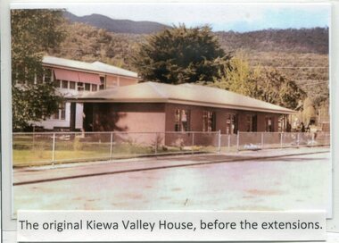
Photographs- Kiewa Valley House (before and after extensions) & Tawonga District General Hospital- Set of 6 colour photographs
... On June 6th, 1980, an appeal to finance a 12 bed nursing wing was launched at a public meeting in Mount Beauty The Hospital and Charities Commission’s development board finally approved the application for government funds to build the 12 bed nursing home in early 1981. The official opening of the nursing home was on March 6th, 1985. Opening of the lounge extensions occurred in May, 1993 Many local residents have taken advantage of facilities ...The establishment of Kiewa Valley House, was a significant victory for residents and senior citizens in the Kiewa Valley district. Plans were laid in the mid 1970’s and a proposal was formulated for a 12 bed unit nursing home to be attached to the Tawonga District General Hospital. The need for an aged care facility in Mount Beauty was prompted by recognition of the high ratio of senior citizens residing in the area. At the time residents had to travel to Beechworth, Wangaratta or Wodonga for care. On June 6th, 1980, an appeal to finance a 12 bed nursing wing was launched at a public meeting in Mount Beauty The Hospital and Charities Commission’s development board finally approved the application for government funds to build the 12 bed nursing home in early 1981. The official opening of the nursing home was on March 6th, 1985. Opening of the lounge extensions occurred in May, 1993 Many local residents have taken advantage of facilities at Kiewa Valley House when they became unable to manage independently in their own homes. This has meant they did not have to face the stress of leaving the area and being separated from their local family and friends. Many SEC workers and their families have been residents of Kiewa Valley House over the years.Set of 6 colour photographs of Kiewa Valley House and original Tawonga District General Hospital in Mt Beauty 1 Kiewa Valley House, before extensions, with old weatherboard hospital in background 2 & 3 Official opening of Kiewa Valley House. 4 & 5 Gardens between Kiewa Valley House and Hospital 5. Kiewa Valley lounge extension 1. The original Kiewa Valley House, before extensions 2. No markings 3. No markings 4. View of the gardens between the weatherboard hospital and Kiewa Valley House 5. Walkway between Hospital & Kiewa Valley House 6. Kiewa Valley House Lounge Room extension tawonga district hospital, kiewa valley house, mt beauty district hospital -
 Kiewa Valley Historical Society
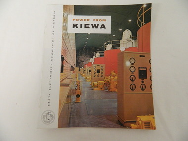
Booklet - S.E.C.V. x2, Power from Kiewa
... public relations employees published booklets to promote the Scheme and the area. In this booklet there are photos of some of the major work constructions with an explanation of how they work and their purpose, a map of the Scheme and an article and photos of tourist facilities and activities that are available....public relations employees published booklets to promote the Scheme and the area. In this booklet there are photos of some of the major work constructions with an explanation of how they work and their purpose, a map of the Scheme and an article and photos of tourist facilities and activities that are available. ...The State Electricity Commission of Victoria constructed the Kiewa Hydro Electric Scheme. Their public relations employees published booklets to promote the Scheme and the area. In this booklet there are photos of some of the major work constructions with an explanation of how they work and their purpose, a map of the Scheme and an article and photos of tourist facilities and activities that are available.This booklet promotes the Kiewa Hydro Electric Scheme and tourism indicating that tourism was recognised as a new industry for the area. The photos give a pictorial history of the area eg. skiing using the Summit T-bar lift and includes the facilities available at the time. The explanation of the Kiewa Hydro Electric Scheme is a basic resource for students interested in Hydro power.Slim booklet with photo of McKay Creek Power Station on the front cover and the title in brown and black at the top. Printed along the spine is State Electricity Commission of Victoria.state electricity commission of victoria. kiewa hydro electric scheme. tourism. t-bar ski tow. falls creek -
 Kiewa Valley Historical Society
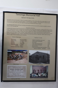
Posters - "Tawonga Remembers" x 5
... facilities, post office, hall and hotel. Activities involved sport, social get togethers eg. dances, fundraising, CWA etc. The posters are a collection of historical photos, documentation and information regarding the history of the town of Tawonga, which is the centre of a farming community in the Kiewa Valley. Tawonga photos of early Tawonga Kiewa Valley Tawonga Remembers Tawonga Hall Posters framed with thin black plastic strip, covered, by glass. Each one has a title re "Tawonga Remembers" and includes print and photos in black and white. Beige background. 1. Tawonga Memorial Hall 2. Opening of the Second Public ...The town of Tawonga is in the Kiewa Valley surrounded by farmland. It is adjacent to Mt Beauty (built from 1946), an SECV town built for the workers on the Kiewa Hydro Electric Scheme which was being constructed from 1911-1961. Tawonga consisted of essential amenities including a store, school, butter factory, sporting facilities, post office, hall and hotel. Activities involved sport, social get togethers eg. dances, fundraising, CWA etc. The posters are a collection of historical photos, documentation and information regarding the history of the town of Tawonga, which is the centre of a farming community in the Kiewa Valley.Posters framed with thin black plastic strip, covered, by glass. Each one has a title re "Tawonga Remembers" and includes print and photos in black and white. Beige background. 1. Tawonga Memorial Hall 2. Opening of the Second Public Hall 1925 3. Public Hall for Tawonga 4. Tawonga Debutante Ball 1947 5. Tawonga Hall Ghosttawonga, photos of early tawonga, kiewa valley, tawonga remembers, tawonga hall -
 Kiewa Valley Historical Society
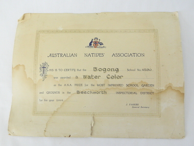
Certificate Prize - Bogong School, Australian Natives Association, 1944
... Kiewa Valley Historical Society Mount Beauty Information Centre 31 Bogong High Plains Rd Mt Beauty high-country Historical document detailing the significance of beautification and pride taken by all who worked and studied at Bogong School 4590 This item represents a period in school and social development when the community covered the beautification of school facilities without State involvement. A period in time when public resources could only cover city and larger townships bogong school 4590 gardening awards beechworth inspectorial This is to certify that the Bogong School 4590 was awarded a water colour as the A.N.A. prize for the most improved school gardening and grounds in the Beechworth Inspectorial District for 1944 signed J. ...Historical document detailing the significance of beautification and pride taken by all who worked and studied at Bogong School 4590This item represents a period in school and social development when the community covered the beautification of school facilities without State involvement. A period in time when public resources could only cover city and larger townships Buff coloured cardboard certificateThis is to certify that the Bogong School 4590 was awarded a water colour as the A.N.A. prize for the most improved school gardening and grounds in the Beechworth Inspectorial District for 1944 signed J. Parker General Secretarybogong school 4590, gardening awards, beechworth inspectorial