Showing 555 items matching "public reserves"
-
 Whitehorse Historical Society Inc.
Document, By-Law No 11, 1935
... Made under Section 197 Subsection 6 and Section 222 of the Local Government Act 1928 agreed to by Council 1935 - Public Reserves, pleasure Grounds etc....By-Law No 11 of the Shire of Blackburn and Mitcham made under Section 197 Subsection 6 and Section 222 of the Local Government Act 1928 agreed to by Council 1935 - Public Reserves, pleasure Grounds etc....Whitehorse Historical Society Inc. 2-10 Deep Creek Road Mitcham melbourne Made under Section 197 Subsection 6 and Section 222 of the Local Government Act 1928 agreed to by Council 1935 - Public Reserves, pleasure Grounds etc. Local government Shire of Blackburn and Mitcham By-laws Parks and Reserves By-Law No 11 of the Shire of Blackburn and Mitcham By-Law No 11 of the Shire of Blackburn and Mitcham made under Section 197 Subsection 6 and Section 222 of the Local Government Act 1928 agreed to by Council 1935 - Public Reserves, pleasure Grounds etc. ...By-Law No 11 of the Shire of Blackburn and MitchamBy-Law No 11 of the Shire of Blackburn and Mitcham made under Section 197 Subsection 6 and Section 222 of the Local Government Act 1928 agreed to by Council 1935 - Public Reserves, pleasure Grounds etc.By-Law No 11 of the Shire of Blackburn and Mitchamlocal government, shire of blackburn and mitcham, by-laws, parks and reserves -
 Greensborough Historical Society
Slide - Photograph, John Ramsdale, Looking from Kalparrin to Partington's Flat: Slide 34, 1990s
... ...public reserves...Part of the John Ramsdale collection of slides and audio visual material. partingtons flat cricket public reserves No caption. Printed maker's mark on slide "Kodak Kodachrome Slide" Colour photograph scanned from slide. ...Photograph shows a sports ground with cricket nets. Looking toward Partington Flat from Kalparrin.Part of the John Ramsdale collection of slides and audio visual material.Colour photograph scanned from slide.No caption. Printed maker's mark on slide "Kodak Kodachrome Slide"partingtons flat, cricket, public reserves -
 Bendigo Historical Society Inc.
Document - PETER ELLIS COLLECTION: NOTES MENTIONING WHIPSTICK REGION
... ...Public Reserves...History House 11 Mackenzie Street Bendigo goldfields BENDIGO Parks and gardens Public Reserves Peter Ellis Collection North/Central L.C.C. ...Four pages of typed notes mentioning the Whipstick Region, Mandurang Forest, Jackass Flat, Diamond Hill Area, One Tree Hill, and the Coliban/Sandhurst Water Supply Reserve. Mentioned are the Birds, Mammals, Geology, Flora, Ground Flora, Orchids,Lilies, Mistletoe, Ferns and Grasses of some of the areas.bendigo, parks and gardens, public reserves, peter ellis collection, north/central l.c.c. region bendigo block, bendigo field naturalists club, shipstick scrub, mandurang forest, one tree hill public park, redvers j eddy, coliban/sandhurst water supply reserve -
Federation University Historical Collection
Book, Historic Sites Survey: North Central Study Area, 1979, 1979
... ...history of public reserves...Barker Library (top floor) Mount Helen goldfields The North Central Study Area included the Shires of Avoca, Bet Bet, east Loddon, Goulburn, Untly, Kara Kara, Korong, Maldon, Marong, Metcalfe, McIvor, Newstead, Strathfieldsaye, Stawell, Talbot, Clunes, Tullaroop and Waranga. castlemaine mount alexander goldfield maldon percydale warrenmang moliagul tarnagulla stuart mill the whipstick whroo rushworth graytown ironbark forest st arnoaud new bendigo landsborough inglewood kurting wedderburn wehla kooroora langham flat mcintyre rheola diamond hill fosterville coliban water works green gully newstead muckleford forest costerfield graytown bailieston waranga irrigaiton system eucalyptus distillery mia mia bridge korokubeal township researce concegella slate quarry chewton fryerstown kingower timor talbot majorca carisbroook clunes st arnaud taradale icomos dunolly limestone castlemaine slate quarry harcourt granite taradale railway viaduct loddon united waterworks trust gouldburn weir carisbrook lock-up history of tree planting in streets history of public reserves r.u. nicholls nurseryman thomas lang francis moss ballarat botanical gardens ballarat school of mines botanical gardens lake wendouree victoria park, ballarat muont holled smith ballaarat old cemetery planting eastern oval ballarat east botanical gardens ballarat east town hall gardens eureka stockade reserve ballarat observatory plantings yarrowee creek plantings yarrowee bluestone channels ballarat woollen mill band and albion mullock heap black hill plantings yarrowee creek channels canadian creek channel specimen vale channel poverty point reserve union jack reserve buninyong imperial mine, buninyong victoria street plantings bridge mall sturt street gardens ballarat avenue of honour plantings white flat oval plantings camp street elms burnt creek 153 page book with white plastic binding. ...The North Central Study Area included the Shires of Avoca, Bet Bet, east Loddon, Goulburn, Untly, Kara Kara, Korong, Maldon, Marong, Metcalfe, McIvor, Newstead, Strathfieldsaye, Stawell, Talbot, Clunes, Tullaroop and Waranga. 153 page book with white plastic binding. It is an historic sites survey for the North Central Study Area commissioned by the Land Conservation Council, the Ministry for COnservation and the Australian Heritage Commission. castlemaine, mount alexander goldfield, maldon, percydale, warrenmang, moliagul, tarnagulla, stuart mill, the whipstick, whroo, rushworth, graytown ironbark forest, st arnoaud, new bendigo, landsborough, inglewood, kurting, wedderburn, wehla, kooroora, langham flat, mcintyre, rheola, diamond hill, fosterville, coliban water works, green gully, newstead, muckleford forest, costerfield, graytown, bailieston, waranga irrigaiton system, eucalyptus distillery, mia mia bridge, korokubeal township researce, concegella slate quarry, chewton, fryerstown, kingower, timor, talbot, majorca, carisbroook, clunes, st arnaud, taradale, icomos, dunolly, limestone, castlemaine slate quarry, harcourt granite, taradale railway viaduct, loddon united waterworks trust, gouldburn weir, carisbrook lock-up, history of tree planting in streets, history of public reserves, r.u. nicholls nurseryman, thomas lang, francis moss, ballarat botanical gardens, ballarat school of mines botanical gardens, lake wendouree, victoria park, ballarat, muont holled smith, ballaarat old cemetery planting, eastern oval, ballarat east botanical gardens, ballarat east town hall gardens, eureka stockade reserve, ballarat observatory plantings, yarrowee creek plantings, yarrowee bluestone channels, ballarat woollen mill, band and albion mullock heap, black hill plantings, yarrowee creek channels, canadian creek channel, specimen vale channel, poverty point reserve, union jack reserve buninyong, imperial mine, buninyong, victoria street plantings, bridge mall, sturt street gardens, ballarat avenue of honour plantings, white flat oval plantings, camp street, elms, burnt creek -
 Ringwood and District Historical Society
Letter, JK McCaskill objecting to the Bowling Club using further public reserve land
... JK McCaskill objecting to the Bowling Club using further public reserve land...JK McCaskill objecting to the Bowling Club using further public reserve land. Undated....City of Ringwood Bowls Club Ringwood Bowling Club Ringwood Bowls Club Lawn bowls bowling JK McCaskill objecting to the Bowling Club using further public reserve land. Undated. JK McCaskill objecting to the Bowling Club using further public reserve land Letter ...1929 saw the establishment of the Ringwood Bowls Club initially located on the land now occupied by the Eastland Shopping Centre. It moved to its current location in Loughnan Road, Ringwood in 1997.JK McCaskill objecting to the Bowling Club using further public reserve land. Undated.city of ringwood bowls club, ringwood bowling club, ringwood bowls club, lawn bowls, bowling -
Canterbury History Group
Article, Meeting at Canterbury, 24/07/1903 12:00:00 AM
... Report of a meeting for the purpose of electing ratepayers represenatives on the committee of management of the public reserve at Canterbury. From "The Reporter" 24 July 1903 emailed by Robin Kelly, 26 April 2007...Canterbury History Group 190A Canterbury Road Canterbury melbourne Canterbury Canterbury Road Canterbury Gardens Canterbury Railway Station Goldings Hall City of Boroondara Report of a meeting for the purpose of electing ratepayers represenatives on the committee of management of the public reserve at Canterbury. From "The Reporter" 24 July 1903 emailed by Robin Kelly, 26 April 2007 Meeting at Canterbury Article ...Report of a meeting for the purpose of electing ratepayers represenatives on the committee of management of the public reserve at Canterbury. From "The Reporter" 24 July 1903 emailed by Robin Kelly, 26 April 2007canterbury, canterbury road, canterbury gardens, canterbury railway station, goldings hall, city of boroondara -
 Lakes Entrance Historical Society
Photograph - Water Bore at Public Reserve Lakes Entrance, 1999
... Water Bore at Public Reserve Lakes Entrance...Colour photograph of the head works including feed pipe of water bore sunk in late 1958 on the Public Reserve bound by Marine Parade and the highway approach to North Arm Bridge, Lakes Entrance, Victoria....Photograph Water Bore at Public Reserve Lakes Entrance ...In late 1958 bore put down in an attempt to obtain good quality water for a reticulated town water supply. Water unsuitable, but during drought years when water supply from Nicholson River was restricted, water from this bore available for public use. Bore plugged, structure removed December 2000. Site marked with plaque March 2001, by Lakes Entrance Historical Society.Colour photograph of the head works including feed pipe of water bore sunk in late 1958 on the Public Reserve bound by Marine Parade and the highway approach to North Arm Bridge, Lakes Entrance, Victoria.water supply, public utilities -
 Mt Dandenong & District Historical Society Inc.
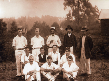
Photograph, Mount Dandenong Cricket Club at Mountain Grange, 1912
... The grounds at Mountain Grange were used for sport long before 1939 when Lillydale Council purchased the property to use as a public reserve and it later became the Kalorama Memorial Reserve....The grounds at Mountain Grange were used for sport long before 1939 when Lillydale Council purchased the property to use as a public reserve and it later became the Kalorama Memorial Reserve. ...Photograph shows ten men in cricket gear & two in ordinary clothes. Names not recorded. The grounds at Mountain Grange were used for sport long before 1939 when Lillydale Council purchased the property to use as a public reserve and it later became the Kalorama Memorial Reserve.kalorama memorial reserve, mountain grange, cricket -
 Federation University Historical Collection
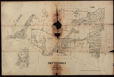
Plan, Smythesdale, County of Grenville, 01/12/1892
... A plan showing the Borough of Smythesdale, Smythesdale, Browns and Scarsdale, allotments, water reserve, Timber reserve, Nintingbool Pre-emptive Right, Reserve for public gardens, Reserve for Cricket Ground, Reserve for Reservoir...Gift of the Squire Family smythesdale scarsdale browns yarrowee carngham samuel barlett sheridan wrigley p. land r. simpson d. davis nintingbool mclachlan a. mclachlan c. taylor w. c. smith d. davies w. williams m. jones t. mcgurk r. selkirk a. mooney A plan showing the Borough of Smythesdale, Smythesdale, Browns and Scarsdale, allotments, water reserve, Timber reserve, Nintingbool Pre-emptive Right, Reserve for public gardens, Reserve for Cricket Ground, Reserve for Reservoir Smythesdale, County of Grenville Plan Department of Lands and Survey T.F. ...This plan is associated with former Ballarat School of Mines Student Richard Squire (1875-1876). Gift of the Squire FamilyA plan showing the Borough of Smythesdale, Smythesdale, Browns and Scarsdale, allotments, water reserve, Timber reserve, Nintingbool Pre-emptive Right, Reserve for public gardens, Reserve for Cricket Ground, Reserve for Reservoirsmythesdale, scarsdale, browns, yarrowee, carngham, samuel barlett, sheridan, wrigley, p. land, r. simpson, d. davis, nintingbool, mclachlan, a. mclachlan, c. taylor, w. c. smith, d. davies, w. williams, m. jones, t. mcgurk, r. selkirk, a. mooney -
 Hume City Civic Collection
Photograph, early 1980s
... Gellibrand Hill was incorporated with Woodlands Park and became a public reserve during the 1980s....Gellibrand Hill was incorporated with Woodlands Park and became a public reserve during the 1980s. gellibrand hill tullamarine airport melbourne skyline george evans collection A coloured landscape photograph with rounded corners taken from Gellibrand Hill and overlooking the Tullamarine Airport which is on the RHS of the photograph. ...The Tullamarine Airport opened in 1970 and replaced Essendon Airport as Melbourne's main airport terminal. Gellibrand Hill was incorporated with Woodlands Park and became a public reserve during the 1980s.A coloured landscape photograph with rounded corners taken from Gellibrand Hill and overlooking the Tullamarine Airport which is on the RHS of the photograph. The Melbourne City skyline can be seen in the distance.gellibrand hill, tullamarine airport, melbourne skyline, george evans collection -
 Robin Boyd Foundation
Document, Plan
... Plan of Eastlakes development NSW (north of Botany) with home units, housing commission, shopping centre and public reserve between Gardeners RD, Universal Street, Grafton Street, Florence Street and Maloney Street....Robin Boyd Foundation 290 Walsh Street South Yarra melbourne Plan of Eastlakes development NSW (north of Botany) with home units, housing commission, shopping centre and public reserve between Gardeners RD, Universal Street, Grafton Street, Florence Street and Maloney Street. ...Plan of Eastlakes development NSW (north of Botany) with home units, housing commission, shopping centre and public reserve between Gardeners RD, Universal Street, Grafton Street, Florence Street and Maloney Street.Photocopy, double page taped on reverse. Handwritten and typewritten. -
 Eltham District Historical Society Inc
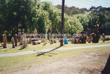
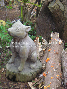
Photograph, Fay Bridge, Leigh Conkie's chainsaw sculptures, Main Road, Eltham, 21 October 2000
... There were so many at times it would be a regular sight to see them sprawled across the public reserve adjacent to his home....There were so many at times it would be a regular sight to see them sprawled across the public reserve adjacent to his home. Fay Bridge Collection 1305 Main Road 2000-10-21 Chainsaw sculpture Eltham Leigh Conkie Main Road 1 image - scanned from colour prints on loan Leigh Conkie's chainsaw sculptures, Main Road, Eltham Photograph Photograph Fay Bridge ...These chainsaw sculptures were created by Leigh Conkie at his home in Main Road. There were so many at times it would be a regular sight to see them sprawled across the public reserve adjacent to his home.fay bridge collection, 1305 main road, 2000-10-21, chainsaw sculpture, eltham, leigh conkie, main road -
 Eltham District Historical Society Inc
Photograph, Fay Bridge, Leigh Conkie's chainsaw sculptures, Main Road, Eltham, n.d
... There were so many at times it would be a regular sight to see them sprawled across the public reserve adjacent to his home....There were so many at times it would be a regular sight to see them sprawled across the public reserve adjacent to his home. Fay Bridge Collection 1305 Main Road Chainsaw sculpture Eltham Leigh Conkie Main Road 17 images - born digital Leigh Conkie's chainsaw sculptures, Main Road, Eltham Photograph Photograph Fay Bridge ...These chainsaw sculptures were created by Leigh Conkie at his home in Main Road. There were so many at times it would be a regular sight to see them sprawled across the public reserve adjacent to his home.fay bridge collection, 1305 main road, chainsaw sculpture, eltham, leigh conkie, main road -
 Friends of Ballarat Botanical Gardens History Group
Work on paper - 1885 Map, Ballarat Botanic and Public Gardens Reserve, 1885
... Ballarat Botanic and Public Gardens Reserve...reserve...Ballarat Botanical Gardens...Ballarat...gardens...1885...Public...Botanic and Public Gardens Reserve: Early Map....Ballarat Botanic and Public Gardens Reserve Work on paper 1885 Map ...Botanic and Public Gardens Reserve: Early Map.This Plan shows how the Ballarat Botanic Gardens had been set out and part of the Lake Wendouree area in 1885.One large cream sheet of paper, folded in two.bottom of the page on the right in blue biro, "From: Jim Reynolds, 29.10.94".john garner collection, garner, dr, map, early, gardens reserve, ballarat botanical gardens, ballarat, gardens, 1885, public, wendouree parade, w. barbour. -
 Ringwood and District Historical Society
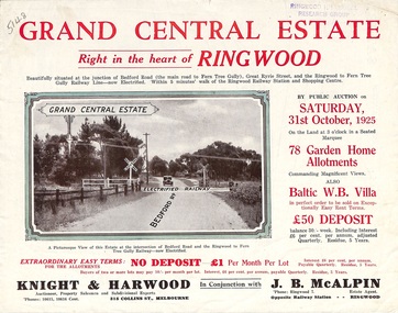
Flyer, Subdivisional Land Auction Sale Brochure, Grand Central Estate, Ringwood, Vic. - 1925
... Douglas Street shown in the estate plan did not eventuate, but was developed as a public reserve. Refer also to Reg. No. 5149 for 1924 auction sale of land also titled Grand View Estate situated further north in Ringwood....Ringwood and District Historical Society 125A Warrandyte Road Ringwood North melbourne Douglas Street shown in the estate plan did not eventuate, but was developed as a public reserve. Refer also to Reg. No. 5149 for 1924 auction sale of land also titled Grand View Estate situated further north in Ringwood. ...Douglas Street shown in the estate plan did not eventuate, but was developed as a public reserve. Refer also to Reg. No. 5149 for 1924 auction sale of land also titled Grand View Estate situated further north in Ringwood.Double sided multi-folded page advertising public auction sale on Saturday, 31st October, 1925, of residential allotments highlighting local facilities, services and layout of the estate. Includes panoramic view of Ringwood and other local photographic images.Subdivision includes Great Ryrie Street, Heathmont Road, Douglas Street, Garden Street, and Bellevue Avenue. Agents - Knight & Harwood, 315 Collins Street, Melbourne, Phone 10615, 10616 Central, in conjunction with J.B. McAlpin, Opposite Railway Station, Ringwood. Phone Ringwood 7. -
 Bendigo Historical Society Inc.
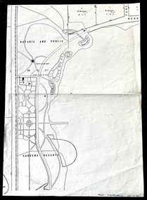
Document - DIAMOND HILL STATE SCHOOL SITE
... On top of page 'extracted from Diamond Hill Public Park Reserve File RS8128, drawn and reproduced at the Department of Lands and Survey, Melbourne'...On top of page 'extracted from Diamond Hill Public Park Reserve File RS8128, drawn and reproduced at the Department of Lands and Survey, Melbourne' Document DIAMOND HILL STATE SCHOOL SITE ...Map (copy) showing the site of Diamond Hill State School, 1873. On top of page 'extracted from Diamond Hill Public Park Reserve File RS8128, drawn and reproduced at the Department of Lands and Survey, Melbourne'bendigo, education, diamond hill state school -
 Greensborough Historical Society
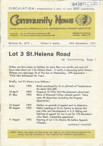
Newsletter, Greenhills and North Greensborough Progress Association, Community News: official journal of the Greenhills and Nth. Greensborough Progress Association. 29th September 1973. Edition No. 8/73, 29/09/1973
... Helena Road... now and before, Forward planning and balanced development, Preservation of the local environment, Public reserves and how to protect them. A digital copy of this Newsletter is available from Greensborough Historical Society....Helena Road... now and before, Forward planning and balanced development, Preservation of the local environment, Public reserves and how to protect them. A digital copy of this Newsletter is available from Greensborough Historical Society. ...This edition includes a report on the Progress Association's September 1973 meeting, Councillor's report, Lot 3 St. Helena Road, In Memoriam [Frank Andrew], School and Kinder news, St. Helena Road... now and before, Forward planning and balanced development, Preservation of the local environment, Public reserves and how to protect them. A digital copy of this Newsletter is available from Greensborough Historical Society.Newsletter, 20 p., illus.greenhills and north greensborough progress association, greenhills -
 Ballarat Heritage Services
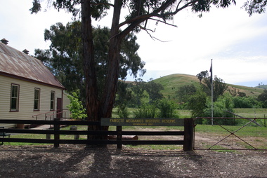
Photograph - Colour, Clare Gervasoni, Fawcett Hall and Public Library, 2015, 11/01//2015
... Fawcett Hall is 14 kilometres North West of Alexandra, North East Victoria, in Spring Creek Road and is set amongst a small picturesque rural farming and business community with hills as a backdrop and Stony Creek running alongside the public reserves property boundary. Part of our hall building dates back to its establishment in 1882. ...Ballarat Heritage Services PO Box 2209 Bakery Hill Post Office goldfields Fawcett Hall is 14 kilometres North West of Alexandra, North East Victoria, in Spring Creek Road and is set amongst a small picturesque rural farming and business community with hills as a backdrop and Stony Creek running alongside the public reserves property boundary. Part of our hall building dates back to its establishment in 1882. ...Fawcett Hall is 14 kilometres North West of Alexandra, North East Victoria, in Spring Creek Road and is set amongst a small picturesque rural farming and business community with hills as a backdrop and Stony Creek running alongside the public reserves property boundary. Part of our hall building dates back to its establishment in 1882. Originally the hall served as a Mechanics Institute and Public Library and later as a primary school.Colour photograph of a weatherboard Hall.fawcett hall and public library, fawcett, fawcett mechanics' institute -
 The Beechworth Burke Museum Research Collection
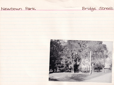
Card (Series) - Index Card, George Tibbits, Bridge Street, Beechworth, 1976
... Property - Newtown Park, Bridge Street, Beechworth - Public Purposes Reserve Ownership details and history Architectural Index Card - Brian Pump and Tony Dugan - Photographers ...The Beechworth Burke Museum Research Collection 103 Ford Street Beechworth Property - Newtown Park, Bridge Street, Beechworth - Public Purposes Reserve Ownership details and history Architectural Index Card - Brian Pump and Tony Dugan - Photographers Beechworth George Tibbits Bridge Street, Beechworth Card Index Card George Tibbits Brian Pump and Tony Dugan from the Block Camera Store Bruce Trethowen Philip Harmer Elizabeth Vines ...George Tibbits, University of Melbourne. Faculty of Architecture, Building and Town & Regional PlanningIndex system that support the research for Beechworth : historical reconstruction / [by] George Tibbits ... [et al]Arranged by street names of BeechworthEach index card includes: street name and number of property, image of property, allotment and section number, property owners and dates of ownership, description of the property according to rate records, property floor plan with dimensions.beechworth, george tibbitsbeechworth, george tibbits -
Torquay and District Historical Society
Book, Scammell wreck photo book
... He was a member of the Spring Creek/Torquay Improvement Association and Torquay Public Reserves Committee that conserved foreshore land from development. ...He was a member of the Spring Creek/Torquay Improvement Association and Torquay Public Reserves Committee that conserved foreshore land from development. ...Compilation of photos relating to the wreck of the Joseph H Scammell, Scammell House and the Pride family.Hardcover book with green cover, 26 pages.non-fictionCompilation of photos relating to the wreck of the Joseph H Scammell, Scammell House and the Pride family. scammell collection, scammell house, shipwrecks great ocean road victoria -
 Kew Historical Society Inc
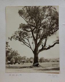
Photograph, Colin Campbell, The Old Gum Tree, 1961
... In 1871, Victoria Park, beside the Boroondara General Cemetery was set aside as a public reserve. As the Park developed, exotic plants were added to existing specimens. ...Kew Historical Society Inc Kew Court House 188 High Street Kew melbourne In 1871, Victoria Park, beside the Boroondara General Cemetery was set aside as a public reserve. As the Park developed, exotic plants were added to existing specimens. ...In 1871, Victoria Park, beside the Boroondara General Cemetery was set aside as a public reserve. As the Park developed, exotic plants were added to existing specimens. In 1910, a photograph of ‘The Oldest Inhabitant: A Giant Red-gum Tree’ in the Park was included in the Jubilee History of Kew. Fifty-one years later the tree was re-photographed by Colin Campbell. A 2007 Master Plan developed for the City of Boroondara advises the retention of this now dead River Red Gum, including a ‘managed risk zone’ and planting under the heavily lopped tree.‘The Old Gum Tree’ in Victoria Park. In the distance a game of cricket is being played on the oval. The old grandstand can be seen in the photo. Photographer Colin Campbell 1961. THE OLD GUM TREE / COLIN CAMPBELL KEW 1961victoria park (kew), colin campbell (photographer), victoria park, red gum tree, eucalypts, kew (vic.) -- historic trees -
![Giant Red Gum. Victoria Park [Kew]](/media/collectors/550653872162f11fb04854aa/items/658f5e1a101c4283c6ae8194/item-media/658f5e76101c4283c6ae8404/item-fit-380x285.jpg?cb=6) Kew Historical Society Inc
Kew Historical Society IncPhotograph - Giant Red Gum. Victoria Park [Kew], c.1950
... In 1871, Victoria Park, beside the Boroondara General Cemetery was set aside as a public reserve. As the Park developed, exotic plants were added to existing specimens. ...Kew Historical Society Inc Kew Court House 188 High Street Kew melbourne In 1871, Victoria Park, beside the Boroondara General Cemetery was set aside as a public reserve. As the Park developed, exotic plants were added to existing specimens. ...In 1871, Victoria Park, beside the Boroondara General Cemetery was set aside as a public reserve. As the Park developed, exotic plants were added to existing specimens. In 1910, a photograph of ‘The Oldest Inhabitant: A Giant Red-gum Tree’ in the Park was included in the Jubilee History of Kew. Fifty-one years later the tree was re-photographed by Colin Campbell. A 2007 Master Plan developed for the City of Boroondara advises the retention of this now dead River Red Gum, including a ‘managed risk zone’ and planting under the heavily lopped tree.This work forms part of the collection assembled by the historian Dorothy Rogers (1905-1973), donated to the Kew Historical Society by her son in 2015. The manuscripts, photographs, maps, and documents were sourced by her from both family and local collections or produced as references for her print publications. Many were directly used by Rogers in writing ‘Lovely Old Homes of Kew’ (1961) and 'A History of Kew' (1973), or the numerous articles on local history that she produced for suburban newspapers. Most of the photographs in the collection include detailed annotations in her hand. The Rogers Collection provides a comprehensive insight into the working habits of a historian from the 1960s to the 1970s. Small monochrome snapshot of the former giant River Red Gum that until it died was a major feature of Victoria Park, Kew. In the background is the red brick wall of the Boroondara General (Kew) Cemetery.Annotation verso: "Giant Red Gum. Victoria Park. Still there over 100 yrs old"dorothy rogers, victoria park (kew), river red gums -
Glen Eira Historical Society
Document - LEMPRIERE AVENUE
... 1/A newspaper cutting from The Argus 12/07/1927 (a print-out of same from Trove), praising the virtues of demolishing former mansion ‘Rozelle’ and erecting a ‘score’ of pretty modern villas from Balaclava Road directly into Green Meadows Gardens, a public reserve. Article describes modernity of homes in great details and the streetscape vistas (1 photo included) including road and pathways. 2/A Caulfield St Kilda Leader, dated 25/08/1993, article with Caulfield residents George and Edna McKaige wanting a planning amendment ‘with teeth’ to protect their Lempriere Ave streetscape. ...Glen Eira Historical Society 965 Glen Huntly Rd Caulfield VIC 3162 melbourne 1/A newspaper cutting from The Argus 12/07/1927 (a print-out of same from Trove), praising the virtues of demolishing former mansion ‘Rozelle’ and erecting a ‘score’ of pretty modern villas from Balaclava Road directly into Green Meadows Gardens, a public reserve. Article describes modernity of homes in great details and the streetscape vistas (1 photo included) including road and pathways. 2/A Caulfield St Kilda Leader, dated 25/08/1993, article with Caulfield residents George and Edna McKaige wanting a planning amendment ‘with teeth’ to protect their Lempriere Ave streetscape. ...1/A newspaper cutting from The Argus 12/07/1927 (a print-out of same from Trove), praising the virtues of demolishing former mansion ‘Rozelle’ and erecting a ‘score’ of pretty modern villas from Balaclava Road directly into Green Meadows Gardens, a public reserve. Article describes modernity of homes in great details and the streetscape vistas (1 photo included) including road and pathways. 2/A Caulfield St Kilda Leader, dated 25/08/1993, article with Caulfield residents George and Edna McKaige wanting a planning amendment ‘with teeth’ to protect their Lempriere Ave streetscape. Andrew Ward, Heritage Architect, identified Lempriere Ave as one of Caulfield’s significant areas, because of its Interwar streetscape.east st kilda, ‘rozelle’ mansions, balaclava, land subdivision, balaclava road, georgian style, spanish mission style, orrong road, greenmeadows gardens, lempriere avenue, leadlight, mckaige george, power and telegraph lines, triple-fronted style, interwar streetscape, mckaige edna, ward andrew, caulfield council, elsternwick, welsh heather (councillor), councillors, akehurst jeff, caulfield heritage watch, spencer david, johnson john dr., ‘kilwinning’, george h., peterson william mrs., ‘melby’, ‘springfield’, rose-watt miss, ‘rozelle’, ‘cressy house’, meadow street, smith wallace m., heron herbert l., ‘goathland’, ‘melbe’, wright james, marsh malcolm reginald, house names, melby avenue, springfield avenue, goathlands street, kilwinning court, heritage studies, town planning -
 Bendigo Historical Society Inc.
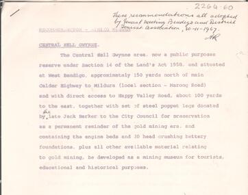
Document - VICTORIA HILL - RECOMMENDATION - MINING PROJECT
... Recommendation for Central Nell Gwynne area, now a public purposes reserve for preservation as a permanent reminder of the gold mining era. ...Recommendation for Central Nell Gwynne area, now a public purposes reserve for preservation as a permanent reminder of the gold mining era. ...Two (a & b) typed copy of a recommendation for mining project, accepted Nov. 1967. Recommendation for Central Nell Gwynne area, now a public purposes reserve for preservation as a permanent reminder of the gold mining era. Victoria Hill Area mentioned for it's geographical and historical significance. The New Chum Hill area rich in historical and mining. Notes on development of the Central Nell Gwynne, Victoria Hill and New or Old Chum Hill areas. Notes prepared by Albert Richardson.mine, gold, victoria hill, victoria hill, recommendation - mining project, central nell gwynne, jack barker, victoria hill area, big 180, victoria quartz, new chum hill (old chum hill), p. m. g. repeater station, mine's department, land's department, lansell, fortuna, a h q survey regiment, lazarus mine, b c v 8 television studio -
 Bayside Gallery - Bayside City Council Art & Heritage Collection
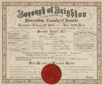
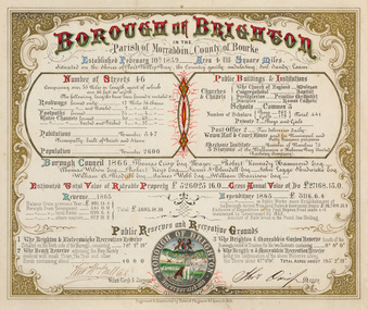
Certificate - Illuminated certificate, Brighton Municipal Certificate, 1872
... Gives details of the municipality in 1872 including list of councillors, number of streets, public buildings and institutions, reserves and recreational grounds, population, value of rateable property and and expenditure. ...Bayside Gallery - Bayside City Council Art & Heritage Collection Corner Wilson and Carpenter Streets Brighton melbourne bayside city council borough of brighton illuminated certificate population rates public buildings WP Allen Mayor Town Clerk Surveyor Councillors Council borough county of Bourke Gives details of the municipality in 1872 including list of councillors, number of streets, public buildings and institutions, reserves and recreational grounds, population, value of rateable property and and expenditure. ...bayside city council, borough of brighton, illuminated, certificate, population, rates, public buildings, wp allen, mayor, town clerk, surveyor, councillors, council, borough, county of bourke -
 Bayside Gallery - Bayside City Council Art & Heritage Collection
Certificate - Illuminated certificate, Hamel & Fergsuon, Brighton Municipal Certificate, 1866
... Gives details of the Borough of Brighton in 1866 including list of councillors, number of streets, public buildings and institutions, reserves and recreational grounds, population, value of rateable property, revenue and expenditure. ...Bayside Gallery - Bayside City Council Art & Heritage Collection Corner Wilson and Carpenter Streets Brighton melbourne bayside city council borough of brighton illuminated certificate population rates public buildings mayor town clerk surveyor councillors council borough county of bourke thomas crisp cr t. crisp census Parish of Moorabbin Hamel & Ferguson coat of arms Gives details of the Borough of Brighton in 1866 including list of councillors, number of streets, public buildings and institutions, reserves and recreational grounds, population, value of rateable property, revenue and expenditure. ...bayside city council, borough of brighton, illuminated, certificate, population, rates, public buildings, mayor, town clerk, surveyor, councillors, council, borough, county of bourke, thomas crisp, cr t. crisp, census, parish of moorabbin, hamel & ferguson, coat of arms -
 Bendigo Historical Society Inc.
Document - ALBERT RICHARDSON COLLECTION: CENTRAL NELL GWYNNE RECOMMENDATIONS FOR MINING MUSEUM
... Written on top right of typed document: 'These recommendations all adopted by General Meeting Bendigo and District Tourist Association, 30.11.1967' Document describes the 'Central Nell Gwynne area, situated at West Bendigo, approximately 150 yards north of main Calder Highway to Mildura, local section Marong Road, which is a public purposes reserve under Section 14 of the Land's Act 1958. ...Written on top right of typed document: 'These recommendations all adopted by General Meeting Bendigo and District Tourist Association, 30.11.1967' Document describes the 'Central Nell Gwynne area, situated at West Bendigo, approximately 150 yards north of main Calder Highway to Mildura, local section Marong Road, which is a public purposes reserve under Section 14 of the Land's Act 1958. ...Six page typed document, signed by Albert Richardson, and a handwritten copy of same. Written on top right of typed document: 'These recommendations all adopted by General Meeting Bendigo and District Tourist Association, 30.11.1967' Document describes the 'Central Nell Gwynne area, situated at West Bendigo, approximately 150 yards north of main Calder Highway to Mildura, local section Marong Road, which is a public purposes reserve under Section 14 of the Land's Act 1958. The steel poppet legs donated by the late Jack Barker to the City Council for preservation be a permanent reminder of the gold mining era and containing the engine beds and 20 head crushing battery foundation, be developed as a mining museum for tourists, educational and historical purposes'bendigo, mining, central nell gwynne -
 Greensborough Historical Society
Sign, Shire of Diamond Valley, Shire of Diamond Valley: Park or Reserve sign, 1964-1994
... This sign would have been at the entry to one of the many public parks and reserves created during the time of the Shire of Diamond Valley (1964-1994). ...This sign would have been at the entry to one of the many public parks and reserves created during the time of the Shire of Diamond Valley (1964-1994). ...Shire of Diamond Valley timber sign. This sign would have been at the entry to one of the many public parks and reserves created during the time of the Shire of Diamond Valley (1964-1994). Following the redistribution of local government areas in 1994, the previous Shire of Diamond Valley was split between City of Banyule and Shire of Nillumbik. Signage would have been replaced to reflect the new 'owners' of the property. The exact location of this sign is unknown.Brown painted Timber sign with yellow writing etched into timbershire of diamond valley, sign, parks - greensborough -
 Bendigo Historical Society Inc.
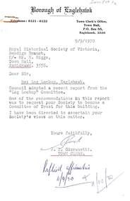
Document - HARRY BIGGS COLLECTION: EAGLEHAWK LOGS APPEAL, 1970
... Item 3 - Instruction in letter form to Bendigo Historical Society Eaglehawk to plan & report the proposed Public Buildings Reserve Eaglehawk. Item 4 - Memorandum to Engineer's Report 17/9/1970 with recommendations for the various areas - Court House, Senior Citizens Club, Historical Society, Council Depot, Toilet Block, Occupied Land. ...Item 3 - Instruction in letter form to Bendigo Historical Society Eaglehawk to plan & report the proposed Public Buildings Reserve Eaglehawk. Item 4 - Memorandum to Engineer's Report 17/9/1970 with recommendations for the various areas - Court House, Senior Citizens Club, Historical Society, Council Depot, Toilet Block, Occupied Land. ...Document. Harry Biggs Collection. Item 1 - A letter with Borough of Eaglehawk letterhead to Mr H. Biggs, Royal Historical Society of Victoria Bendigo Branch, dated 9/9/1970, Re the Log Lock-up, Eaglehawk. It acknowledges a report sent to it & says a request for the Historical Society to become a committee of Trust for this building is being ascertained. Stamped with Reply affirmative11/10/70. Item 2 - a similar letter dated 18/9/1970 saying final decision will be held over. Item 3 - Instruction in letter form to Bendigo Historical Society Eaglehawk to plan & report the proposed Public Buildings Reserve Eaglehawk. Item 4 - Memorandum to Engineer's Report 17/9/1970 with recommendations for the various areas - Court House, Senior Citizens Club, Historical Society, Council Depot, Toilet Block, Occupied Land. Item 5 - Formal Engineers plan of Borough of Eaglehawk. Item 6 - Log Lock-up Appeal - list of donors.place, building, site, harry biggs collection, log lock-up appeal, eaglehawk -
 Federation University Historical Collection
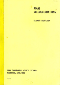
Book, Final recommendations Ballarat Study Area Land Conservation Council, Victoria, 1982, 1982
... The contents of the report include: Parks, reference areas, wildlife reserves, water production, hardwood production, softwood production, flora Reserves and Flora and Fauna reserves, bushland reserves, historic area and reserves, rivers and streams, Roadside conservation and Highway parks, Education areas and School Plantations, Lake Reserves, geological reserves, recreation, scenic reserves, agriculture, mineral and stone production, utilities and survey, township land, Uncommitted Land, military training, other reserves and public land. Maps include: The Study area 1: 250 000 Supplementary Maps...The contents of the report include: Parks, reference areas, wildlife reserves, water production, hardwood production, softwood production, flora Reserves and Flora and Fauna reserves, bushland reserves, historic area and reserves, rivers and streams, Roadside conservation and Highway parks, Education areas and School Plantations, Lake Reserves, geological reserves, recreation, scenic reserves, agriculture, mineral and stone production, utilities and survey, township land, Uncommitted Land, military training, other reserves and public land. Maps include: The Study area 1: 250 000 Supplementary Maps Final recommendations Ballarat Study Area Land Conservation Council, Victoria, 1982 Book Book ...Yellow soft covered report of 95 pages . The contents of the report include: Parks, reference areas, wildlife reserves, water production, hardwood production, softwood production, flora Reserves and Flora and Fauna reserves, bushland reserves, historic area and reserves, rivers and streams, Roadside conservation and Highway parks, Education areas and School Plantations, Lake Reserves, geological reserves, recreation, scenic reserves, agriculture, mineral and stone production, utilities and survey, township land, Uncommitted Land, military training, other reserves and public land. Maps include: The Study area 1: 250 000 Supplementary Mapsland conservation authority, ballarat, endowment plantations, pine plantations, langi ghiran state park, mount buangor state park, enfield state park, ballarat-creswick regional park, rossbridge, black lake, flax mill swamp, dereel lagoon, lake bolac, lake wongan, langi ghiran reservoir, gong gong reservoir, pincotts reservoir, beales reservoir, wilsons reservoir, moorabool reservoir, korweinguboora, korweinguborra reservoir, learmonth bores, sago hill, illabarook reservoir, ballarat water commission, dunneworthy, mount cole, mont lonarch, ben major, waterloo, trawalla, linton, ross creek, canadian, shepherds flat, lal lal, mount doran, raglan, chute, carngham, buninyong, watsons hill, enfield, cape clear, illabrook, rokewood junction, mount warrenheip, nerrina, jubilee, golden stream, australasian deep lead mine, happy valley school, piggoreet, berringa, bulldog, ballarat common, wildlife, water, timber, flora, rivers, geology, agriculture, warrenheip, biodiversity