Showing 46 items matching "pump system"
-
 Flagstaff Hill Maritime Museum and Village
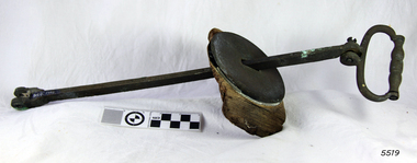
Pump
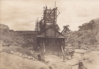
... ...pump system...Part of a pump system. Has been attached to a piece of wood. ...Flagstaff Hill Warrnambool Shipwrecked coast Flagstaff Hill Maritime Museum Maritime Museum Shipwreck coast Flagstaff Hill Maritime Village Great Ocean Road Loch Line LOCH ARD Captain Gibbs Eva Carmichael Tom Pearce Glenample Station Mutton Bird Island LOCH ARD Gorge pump system pump Part of a pump system. Has been attached to a piece of wood. ...HISTORY OF THE LOCH ARD The LOCH ARD belonged to the famous Loch Line which sailed many ships from England to Australia. Built in Glasgow by Barclay, Curdle and Co. in 1873, the LOCH ARD was a three-masted square rigged iron sailing ship. The ship measured 262ft 7" (79.87m) in length, 38ft (11.58m) in width, 23ft (7m) in depth and had a gross tonnage of 1693 tons. The LOCH ARD's main mast measured a massive 150ft (45.7m) in height. LOCH ARD made three trips to Australia and one trip to Calcutta before its final voyage. LOCH ARD left England on March 2, 1878, under the command of Captain Gibbs, a newly married, 29 year old. She was bound for Melbourne with a crew of 37, plus 17 passengers and a load of cargo. The general cargo reflected the affluence of Melbourne at the time. On board were straw hats, umbrella, perfumes, clay pipes, pianos, clocks, confectionary, linen and candles, as well as a heavier load of railway irons, cement, lead and copper. There were items included that intended for display in the Melbourne International Exhibition in 1880. The voyage to Port Phillip was long but uneventful. At 3am on June 1, 1878, Captain Gibbs was expecting to see land and the passengers were becoming excited as they prepared to view their new homeland in the early morning. But LOCH ARD was running into a fog which greatly reduced visibility. Captain Gibbs was becoming anxious as there was no sign of land or the Cape Otway lighthouse. At 4am the fog lifted. A man aloft announced that he could see breakers. The sheer cliffs of Victoria's west coast came into view, and Captain Gibbs realised that the ship was much closer to them than expected. He ordered as much sail to be set as time would permit and then attempted to steer the vessel out to sea. On coming head on into the wind, the ship lost momentum, the sails fell limp and LOCH ARD's bow swung back. Gibbs then ordered the anchors to be released in an attempt to hold its position. The anchors sank some 50 fathoms - but did not hold. By this time LOCH ARD was among the breakers and the tall cliffs of Mutton Bird Island rose behind the ship. Just half a mile from the coast, the ship's bow was suddenly pulled around by the anchor. The captain tried to tack out to sea, but the ship struck a reef at the base of Mutton Bird Island, near Port Campbell. Waves broke over the ship and the top deck was loosened from the hull. The masts and rigging came crashing down knocking passengers and crew overboard. When a lifeboat was finally launched, it crashed into the side of LOCH ARD and capsized. Tom Pearce, who had launched the boat, managed to cling to its overturned hull and shelter beneath it. He drifted out to sea and then on the flood tide came into what is now known as LOCH ARD Gorge. He swam to shore, bruised and dazed, and found a cave in which to shelter. Some of the crew stayed below deck to shelter from the falling rigging but drowned when the ship slipped off the reef into deeper water. Eva Carmichael had raced onto deck to find out what was happening only to be confronted by towering cliffs looming above the stricken ship. In all the chaos, Captain Gibbs grabbed Eva and said, "If you are saved Eva, let my dear wife know that I died like a sailor". That was the last Eva Carmichael saw of the captain. She was swept off the ship by a huge wave. Eva saw Tom Pearce on a small rocky beach and yelled to attract his attention. He dived in and swam to the exhausted woman and dragged her to shore. He took her to the cave and broke open case of brandy which had washed up on the beach. He opened a bottle to revive the unconscious woman. A few hours later Tom scaled a cliff in search of help. He followed hoof prints and came by chance upon two men from nearby Glenample Station three and a half miles away. In a state of exhaustion, he told the men of the tragedy. Tom returned to the gorge while the two men rode back to the station to get help. By the time they reached LOCH ARD Gorge, it was cold and dark. The two shipwreck survivors were taken to Glenample Station to recover. Eva stayed at the station for six weeks before returning to Ireland, this time by steamship. In Melbourne, Tom Pearce received a hero's welcome. He was presented with the first gold medal of the Royal Humane Society of Victoria and a £1000 cheque from the Victorian Government. Concerts were performed to honour the young man's bravery and to raise money for those who lost family in the LOCH ARD disaster. Of the 54 crew members and passengers on board, only two survived: the apprentice, Tom Pearce and the young woman passenger, Eva Carmichael, who lost all of her family in the tragedy. Ten days after the LOCH ARD tragedy, salvage rights to the wreck were sold at auction for £2,120. Cargo valued at £3,000 was salvaged and placed on the beach, but most washed back into the sea when another storm developed. The wreck of LOCH ARD still lies at the base of Mutton Bird Island. Much of the cargo has now been salvaged and some was washed up into what is now known as LOCH ARD Gorge. Cargo and artefacts have also been illegally salvaged over many years before protective legislation was introduced. One of the most unlikely pieces of cargo to have survived the shipwreck was a Minton porcelain peacock - one of only nine in the world. The peacock was destined for the Melbourne International Exhibition in 1880. It had been well packed, which gave it adequate protection during the violent storm. Today, the Minton peacock can be seen at the Flagstaff Hill Maritime Museum in Warrnambool. From Australia's most dramatic shipwreck it has now become Australia's most valuable shipwreck artefact and is one of very few 'objects' on the Victorian State Heritage Register. Flagstaff Hill’s collection of artefacts from LOCH ARD is significant for being one of the largest collections of artefacts from this shipwreck in Victoria. It is significant for its association with the shipwreck, which is on the Victorian Heritage Register (VHR S417). The collection is significant because of the relationship between the objects, as together they have a high potential to interpret the story of the LOCH ARD. The LOCH ARD collection is archaeologically significant as the remains of a large international passenger and cargo ship. The LOCH ARD collection is historically significant for representing aspects of Victoria’s shipping history and its potential to interpret sub-theme 1.5 of Victoria’s Framework of Historical Themes (living with natural processes). The collection is also historically significant for its association with the LOCH ARD, which was one of the worst and best known shipwrecks in Victoria’s history. Part of a pump system. Has been attached to a piece of wood. Possibly a cistern plunger. From the Loch Ard.flagstaff hill, warrnambool, shipwrecked coast, flagstaff hill maritime museum, maritime museum, shipwreck coast, flagstaff hill maritime village, great ocean road, loch line, loch ard, captain gibbs, eva carmichael, tom pearce, glenample station, mutton bird island, loch ard gorge, pump system, pump -
 Moorabbin Air Museum
Drawing - Liquid Fuel Starter System Test Rig Fuel Pump System, Commonwealth Aircraft Corporation Drawing No. 27-45001
... Liquid Fuel Starter System Test Rig Fuel Pump System ...Moorabbin Air Museum Moorabbin Airport 12 First Street Moorabbin melbourne Commonwealth Aircraft Corporation Drawing No. 27-45001 Drawing Liquid Fuel Starter System Test Rig Fuel Pump System ... -
Moorabbin Air Museum
Drawing - Pump Assembly Utility System, Commonwealth Aircraft Corporation Pty Ltd Drawing No. 26-58604
... Pump Assembly Utility System ...Moorabbin Air Museum Moorabbin Airport 12 First Street Moorabbin melbourne Commonwealth Aircraft Corporation Pty Ltd Drawing No. 26-58604 Drawing Pump Assembly Utility System ... -
Moorabbin Air Museum
Drawing - Pump Assembly Utility System, Commonwealth Aircraft Corporation Drawing No. 26-58604
... Pump Assembly Utility System...Moorabbin Air Museum Moorabbin Airport 12 First Street Moorabbin melbourne Commonwealth Aircraft Corporation Drawing No. 26-58604 Drawing Pump Assembly Utility System ... -
 Lakes Entrance Historical Society
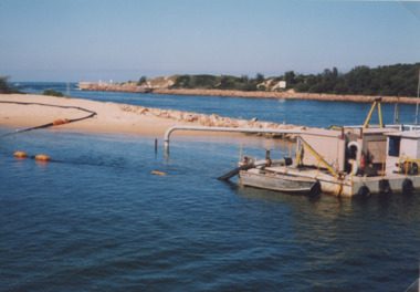
Photograph, small dredge Lakes Entrance Victoria, 1/04/1999 12:00:00 AM
... Colour photograph of small dredge and pipeline from dredge across sand beside entrance at launch of six month trial of sand transfer pumping system at New Works area Lakes Entrance Victoria. ...Lakes Entrance Historical Society 4 Marine Parade Lakes Entrance gippsland Environment Waterfront Colour photograph of small dredge and pipeline from dredge across sand beside entrance at launch of six month trial of sand transfer pumping system at New Works area Lakes Entrance Victoria. ...Colour photograph of small dredge and pipeline from dredge across sand beside entrance at launch of six month trial of sand transfer pumping system at New Works area Lakes Entrance Victoria. Plus two other photos including Barrie Martin of Gippsland Ports, Marie Tehan Minister for Conservation Forests and Land, environment, waterfront -
 Bendigo Historical Society Inc.
Document - DRAINAGE PROBLEMS - BAILING OPERATIONS
... It was not however intended to introduce a pumping system for the present.''...It was not however intended to introduce a pumping system for the present.'' Document DRAINAGE PROBLEMS - BAILING OPERATIONS ...Handwritten extracts from the Bendigo Advertiser 17/8/1910 Col. 2. Extract mentions Bailing Operations - A Week's Progress. Water at the Victoria Quartz lowered 139 ft for the week. Bailing carried out at Lansell's 180, Lazarus, New Chum Consolidated and New Chum Railway Mines. Cost of bailing about 200 pound per week and the Government is contributing half. The balance is being found from the Victoria Quartz, Victoria Consols, Ironbark, Hercules and Energetic and Lansell's Estate. Expenditure over 6 weeks has amounted to over 1200 pounds. ''Mr McBride, Minister for Mines,said work was to be continued for the present at all events. Mr Merrin, Chief Inspector of Mines, said the Dept's aim was to keep the whole of contributing mines on the New Chum line unwatered, and also to enable the Victoria Quartz to go on with its sinking. It was not however intended to introduce a pumping system for the present.''document, gold, drainage problems, drainage problems, bendigo advertiser 17/8/1910 page 3 col 2, victoria quartz, lansell's 180, lazarus, new chum consolidated, new chum railway, victoria consols, ironbark, hercules and energetic, lansell's estate, mr mcbride, mr merrin, new chum line -
 The Beechworth Burke Museum
Photograph
... Open cut sluicing involved the use of high-powered hoses which used the centrifugal sand pump system (known as hydraulic sluicing) which broke down the soil which was then processed for quartz, gold and other materials. ...Open cut sluicing involved the use of high-powered hoses which used the centrifugal sand pump system (known as hydraulic sluicing) which broke down the soil which was then processed for quartz, gold and other materials. ...This photograph dating between the 1850s and early 1900s depicts an open cut sluicing site located in Allan's Flat looking upon the open cut from Staghorn Flat Number 1. Sluicing was undertaken in the area from 1850 to 1904. The image depicts a location mined by Yackandandah Sluicing Co. It portrays and open space with pipes laying on the ground and connected to pipes leaving the barge. These pipes were used to wash and seperate the qaurtz. There are two small buildings on high ground over looking the barge. Yackandandah Sluicing Co. was created by J.A. Wallace in the 1880s. The Yackandandah Sluicing Co. operated from the mid-1880s to the early 1900s, when resources eventually ran out. Open cut sluicing involved the use of high-powered hoses which used the centrifugal sand pump system (known as hydraulic sluicing) which broke down the soil which was then processed for quartz, gold and other materials. After the resources where drained, Wallace reaped the benefits of his mining business. Allan's Flat is located on the Yackandandah Creek, and is 10km north-east of Yackandandah and 20km south of Wodonga in Victoria's regional north-east. Allan's Flat was initially used to mine gold through alluvial methods, however that came to an end with little results. The mining business was then revived by J.A. Wallace with the introduction of hydraulic sluicing.The search for gold is ingrained into the history of Victoria and therefore, images like this one which portray an open cut sluicing site can reveal important information for society and technology for the date when the photograph was taken. This image is of important historical significance for its ability to convey information about sluicing and the methods used to find gold and other minerals in the lat 19th Century. It also shows a location where sluicing was undertook which provides insight into the impact of sluicing on the environment at a time when it was done. This image is important for current research into the history of Allan's Flat, a small regional location near Yackandandah in Victoria's North East. Therefore, this image has the capacity to be beneficial for research into society and the motivations of those living and working in this region during this period and therefore, has social significance. The Beechworth Burke Museum has additional images relating to gold sluicing and Allan's Flat which can be analysed and studied alongside images like this one.Sepia coloured retangular photograph printed on gloss photographic paper mounted on board.Revers: Sluicing at Allan's Fortallan's flat, north east gold, sluicing, gold sluicing, hydraulic sluicing, mining, gold and quartz mine, beechworth, burke museum, yackandandah -
 Department of Energy, Environment and Climate Action
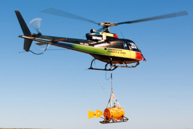
Aerial Drip Torch (ADT) or "Dragon"
... Also known as a dragon helitorch it consisted of a large 135-litre tank containing jellied petrol, a displacement pump, propane ignition system, burner nozzle and fire extinguisher system. ...Also known as a dragon helitorch it consisted of a large 135-litre tank containing jellied petrol, a displacement pump, propane ignition system, burner nozzle and fire extinguisher system. ...The Aerial Drip Torch (ADT) was an idea conceived in Canada in the 1970s by John Muraro It was developed in 1982 by the New Zealand Forest Service to become the Ashley Aphid Helitorch. Forestry Tasmania acquired one of the machines and modified it in February 1987. Also known as a dragon helitorch it consisted of a large 135-litre tank containing jellied petrol, a displacement pump, propane ignition system, burner nozzle and fire extinguisher system. It was first trialled in Victoria at Swifts Creek in 1991 and the Aerial Drip Torch (ADT) has now become standard practice.Two Aerial Drip Torches (ADTs) were built in the 1990s by the Fire Equipment Development Centre at North Altona, They were developed in conjunction with the Department of Conservation and Land Management in Western Australia. The first was trialled during the 1991/92 autumn burning season. The machine proved to be successful and a second machine was introduced in 1998 to assist with burning operations across the State. The ADTs were commonly used for regeneration burning (controlled burning of logging slash). The first ADT introduced in 1992 had a dry weight of 160kg and a capacity of 130 litres, providing about an hour of operation. Following initial use, systematic modifications were adapted including improved ignition of gel at the drop tube, installation of an air bleed valve at the pump to assist pump priming and improved mounting brackets for the CO2 bottles and propane canister attached to the machine. The second, and lightweight ADT, introduced in 1998 had a dry weight of 68kg and a capacity of 200 litres due to a smaller lightweight frame and plastic (Polyfin) tank. In operation the ADT is suspended below a helicopter via four strops attached to the vessel and a cable to the helicopter cargo hook. Gelled fuel is dispensed via a drop tube which is attached to the pump outlet of the machine, and ignited via a gas torch. Safety features built into the first ADT were: a brass melting plug designed to be activated at 200 C bursting disc designed to burst at170 Kpa should the vessel over pressurise. a pressure relief valve set to 35 Kpa ( vessel operated between 16 &34 Kpa) a low pressure sensor designed to shut down the machine should the vessel pressure drop below 15Kpa. the vessel is filled with CO2 above the gelled fuel to eliminate ignition with in the vessel. CO2 is used to expel any residue of ignited gel from the drop tube to prevent ignition when flying outside the boundaries of the burning area. See FIRE EQUIPMENT NOTE - 46 [ https://drive.google.com/file/d/1CKtcH-3rUlrtbE9dkNP27PYT2-raVVhF/view ]forests commission victoria (fcv), bushfire, bushfire aviation, planned burning -
 Orbost & District Historical Society
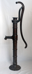
pump, late 19th -early 20th century
... Hand operated water pumps were used to supply water prior to the widespread use of windmill pumps, electric pumps and city water systems. Usually an old pump was made from cast iron, wood or tin. ...Orbost & District Historical Society Ruskin Street Orbost gippsland Hand operated water pumps were used to supply water prior to the widespread use of windmill pumps, electric pumps and city water systems. Usually an old pump was made from cast iron, wood or tin. ...Hand operated water pumps were used to supply water prior to the widespread use of windmill pumps, electric pumps and city water systems. Usually an old pump was made from cast iron, wood or tin. Pumps were very important to people up through the 19th century as farm houses seldom had indoor plumbing with running water. These pumps were also used for outdoor irrigation or laundry purposes.Hand operated water pumps were important before indoor plumbing was adequate. An iron water pump - hand-operated by a lever to the side. A plunger moves up and down (missing). It has a spout and has been painted brown.pump-water irrigation rural -
 The Beechworth Burke Museum
Photograph, 1907-8
... Open cut sluicing involved the use of high-powered hoses which used the centrifugal sand pump system (known as hydraulic sluicing) which broke down the soil which was then processed for gold and other precious metals. ...Open cut sluicing involved the use of high-powered hoses which used the centrifugal sand pump system (known as hydraulic sluicing) which broke down the soil which was then processed for gold and other precious metals. ...The photo from 1907-8 is a sepia print, depicting a small valley with building at base. There are flumes visible above areas of water, trees on hills and a few small cottages on the hillside. Cock's Pioneer Gold & Tin Sluicing Co NZ No 2 Site. The photo was taken of Matthews Gully looking west. Sluicing was undertaken in the area from 1900 to 1942 with some short breaks between these periods. The image depicts a location mined by Cocks Pioneer Gold and Tin Sluicing Company (as recorded on the annotation on the card mount) The Cocks Pioneer Gold and Tin Mines N.L was one of El Dorado's two largest open cut sluicing mines of the 20th Century. The other was named the Cocks El Dorado Gold Dredging Company. The Cocks Pioneer Mines operated from 1901 until 1941 and found a total of 117,378 ounces of Gold and 1,673 tones of tin concentrates over these years. The Cocks company was formed in 1898 and operated until 1941. Open cut sluicing involved the use of high-powered hoses which used the centrifugal sand pump system (known as hydraulic sluicing) which broke down the soil which was then processed for gold and other precious metals. From 1914 , four years after this image was captured, the company reformed to Cocks Pioneer Gold and Tin Mines NL (previously it was known as Cocks Pioneer Sluicing Co) and undertook large scale sluicing operations until 1929 and then 1934-1941. El Dorado is located on Reedy Creek and is surrounded by forested country to the north and east. It is 20 km east of Wangaratta in Victoria's regional north-east. John Cock was the son of a Cornish minor who arrived in El Dorado in 1858. Cock founded his gold and tin mining company which ran successfully for many years in the El Dorado region. It was an open cut sluicing company because of the abandonment of underground mining after this was deemed too dangerous. In 1935 Cock's El Dorado Company commissioned the floating dredge which is still visible in El Dorado today. The dredge was built by the Thompson engineering works, Castlemaine, and weighed over 2,000 tones and today has a place on the Victorian Registers of historic buildings. Interestingly, the name El Dorado does not derive from the gold in the region, but from the Barambogie pastoral run completed by William Baker in 1840-1841. Gold was discovered in El Dorado 1854 but the gold was too deep for individual prospectors to find, it required the use of heavy machinery.The search for gold is ingrained into the history of Victoria and therefore, images like this one which portray an open cut sluicing site can reveal important information for society and technology for the date when the photograph was taken. This image is of important historical significance for its ability to convey information about sluicing and the methods used to find gold in 1910. It also shows a location where sluicing was undertook which provides insight into the impact of sluicing on the environment at a time when it was done. This image is important for current research into the history of El Dorado, a small regional location near Wangaratta in Victoria's North East. Therefore, this image has the capacity to be beneficial for research into society and the motivations of those living and working in this region during this period and therefore, has social significance. The Beechworth Burke Museum has additional images relating to gold sluicing and El Dorado which can be analysed and studied alongside images like this one.Sepia coloured rectangle photograph printed on gloss photographic paper Reverse: 1997. 2613/ A02613/ No2 site/ Matthews Gully/ Cocks Pioneer G&T. ?? Co NZ/ No2 Site looking West/ 1907-8/ (7)sluicing, hydraulic sluicing, 1907, 1908, mining, cock's pioneer gold & tin sluicing co nz, nz, site no 2, matthews gully, west, valley, building, cottages, hillside, trees, water, gold and tin mine -
 City of Warrnambool Rowing Club
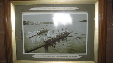
Photograph, The Final for Mrs Rolfe's Trophy
... He resoiled the land, put in a water supply reservoir, water tanks and pumps, a reticulation system and a windmill- 50 feet high with four sails 18 feet high and 4 1/2 wide. ...He resoiled the land, put in a water supply reservoir, water tanks and pumps, a reticulation system and a windmill- 50 feet high with four sails 18 feet high and 4 1/2 wide. ...Mrs George Rolfe was the wife of the owner of Lyndoch. He was a Melbourne tea merchant, who owned 216 acres of the Shipley estate further up the Hopkins River. In the late 1870s he bought 2 acres of land and house along the Hopkins near the bridge and developed into Lyndoch. By 1883 he increased to 50 acres. He resoiled the land, put in a water supply reservoir, water tanks and pumps, a reticulation system and a windmill- 50 feet high with four sails 18 feet high and 4 1/2 wide. George Rolfe died in 1919 and the present Lyndoch House was built in 1925. Source: By These We Flourish, A History of Warrnambool by C.E. Sayers and P.L. Yule Edition 1 A4 landscape black and white photograph of a mens rowing four on the Hopkins River, Warrnambool.The Final for Mrs Rolfe's Trophy Presented by Mrs George Rolfe by W.R.C.lyndoch, lyndoch warrnambool, city of warrnambool rowing club, warrnambool rowing club, george rolfe -
 The Beechworth Burke Museum
Photograph, 1910 - 1911
... Open cut sluicing involved the use of high-powered hoses which used the centrifugal sand pump system (known as hydraulic sluicing) which broke down the soil which was then processed for gold and other precious metals. ...Open cut sluicing involved the use of high-powered hoses which used the centrifugal sand pump system (known as hydraulic sluicing) which broke down the soil which was then processed for gold and other precious metals. ...This photograph depicts Cock's Pioneer G & T Sluicing site No. 4 in El Dorado. Looking eastwards, the photo captures a wooden and tin building with various mining equipment strewn in the foreground. Underneath the verandah, figures can be seen. These are believed to be a Mr. Hollister (left), Mrs. Breustedt (4th from left), children Min and Chris Breustedt, and Kate Timmons holding a girl's hand. The Cocks Pioneer Gold and Tin Mines N.L was one of El Dorado's two largest open-cut sluicing mines of the 20th Century. The other was named the Cocks El Dorado Gold Dredging Company. The Cocks Pioneer Mines operated from 1901 until 1941 and found a total of 117,378 ounces of Gold and 1,673 tones of tin concentrates over these years. The Cocks company was formed in 1898 and operated until 1941. Open cut sluicing involved the use of high-powered hoses which used the centrifugal sand pump system (known as hydraulic sluicing) which broke down the soil which was then processed for gold and other precious metals. From 1914, four years after this image was captured, the company reformed to Cocks Pioneer Gold and Tin Mines NL (previously it was known as Cocks Pioneer Sluicing Co) and undertook large-scale sluicing operations until 1929 and then 1934-1941. The Cocks Pioneer was an extremely successful mining company during the 20th century. In the Annual Report of the Secretary for Mines for the year 1915, the Cocks Pioneer was the largest producer of gold and tin collecting 5,535 ozs. of gold and £7,500 of tin. Twenty years later in 1935, Cocks Pioneer was still one of the most profitable mines in Victoria, ranking as the second-highest dividend paying mine. The company produced a total of 3,650 kg of gold. El Dorado is located on Reedy Creek and is surrounded by forested country to the north and east. It is 20 km east of Wangaratta in Victoria's regional northeast. John Cock was the son of a Cornish miner who arrived in El Dorado in 1858. Cock founded his gold and tin mining company which ran successfully for many years in the El Dorado region. It was an open-cut sluicing company because of the abandonment of underground mining after this was deemed too dangerous. In 1935 Cock's El Dorado Company commissioned the floating dredge which is still visible in El Dorado today. The dredge was built by the Thompson engineering works, Castlemaine, and weighed over 2,000 tones and today has a place on the Victorian Registers of historic buildings. Interestingly, the name El Dorado does not derive from the gold in the region, but from the Barambogie pastoral run completed by William Baker in 1840-1841. Gold was discovered in El Dorado in 1854 but the gold was too deep for individual prospectors to find, it required the use of heavy machinery.The search for gold is ingrained into the history of Victoria and therefore, images like this one which portray an open cut sluicing site can reveal important information for society and technology for the date when the photograph was taken. This image is of important historical significance for its ability to convey information about sluicing and the methods used to find gold in 1910. It also shows a location where sluicing was undertook which provides insight into the impact of sluicing on the environment at a time when it was done. This image is important for current research into the history of El Dorado, a small regional location near Wangaratta in Victoria's North East. Therefore, this image has the capacity to be beneficial for research into society and the motivations of those living and working in this region during this period and therefore, has social significance. The Beechworth Burke Museum has additional images relating to gold sluicing and El Dorado which can be analysed and studied alongside images like this one.A black and white copy of a sepia coloured rectangular photograph printed on matte photographic paper mounted on boardObverse: COCKS PIONEER G + T SL CO, N.L. / 1910 - 11 / NO 4 SITE LOOKING EAST / 4 Reverse: 1997.2508 / AUG 29 1909cocks pioneer gold and tin sluicing company, el dorado, mining, sluicing, hydraulic mining, hollister, breustedt, timmons, gold, tin, gold rush, victoria -
 The Beechworth Burke Museum
Photograph, 1910
... Open cut sluicing involved the use of high-powered hoses which used the centrifugal sand pump system (known as hydraulic sluicing) which broke down the soil which was then processed for gold and other precious metals. ...Open cut sluicing involved the use of high-powered hoses which used the centrifugal sand pump system (known as hydraulic sluicing) which broke down the soil which was then processed for gold and other precious metals. ...This photograph dating to 1910 depicts an open cut sluicing site located in El Dorado captured looking east up the open cut from the number 3 Barge site. Sluicing was undertaken in the area from 1900 to 1942 with some short breaks between these periods. The image depicts a location mined by Cocks Pioneer Gold and Tin Sluicing Company (as recorded on the annotation on the card mount). It portrays open cut rocks with a crevice in the center of the image where the sluicing was being undertaken. There is a small timber structure on the right of the image which could be an entrance to a mine or supports made of wood to prevent a cave in at the open cut site and above the cut rock there is bush. The timber structure has rail tracks on top of the bridge which could suggest the identification of this structure as a mine entrance. The rail tracks were used for little carts which hauled soil from the mine. The Cocks Pioneer Gold and Tin Mines N.L was one of El Dorado's two largest open cut sluicing mines of the 20th Century. The other was named the Cocks El Dorado Gold Dredging Company. The Cocks Pioneer Mines operated from 1901 until 1941 and found a total of 117,378 ounces of Gold and 1,673 tones of tin concentrates over these years. The Cocks company was formed in 1898 and operated until 1941. Open cut sluicing involved the use of high-powered hoses which used the centrifugal sand pump system (known as hydraulic sluicing) which broke down the soil which was then processed for gold and other precious metals. From 1914 , four years after this image was captured, the company reformed to Cocks Pioneer Gold and Tin Mines NL (previously it was known as Cocks Pioneer Sluicing Co) and undertook large scale sluicing operations until 1929 and then 1934-1941. El Dorado is located on Reedy Creek and is surrounded by forested country to the north and east. It is 20 km east of Wangaratta in Victoria's regional north-east. John Cock was the son of a Cornish minor who arrived in El Dorado in 1858. Cock founded his gold and tin mining company which ran successfully for many years in the El Dorado region. It was an open cut sluicing company because of the abandonment of underground mining after this was deemed too dangerous. In 1935 Cock's El Dorado Company commissioned the floating dredge which is still visible in El Dorado today. The dredge was built by the Thompson engineering works, Castlemaine, and weighed over 2,000 tones and today has a place on the Victorian Registers of historic buildings. Interestingly, the name El Dorado does not derive from the gold in the region, but from the Barambogie pastoral run completed by William Baker in 1840-1841. Gold was discovered in El Dorado 1854 but the gold was too deep for individual prospectors to find, it required the use of heavy machinery.The search for gold is ingrained into the history of Victoria and therefore, images like this one which portray an open cut sluicing site can reveal important information for society and technology for the date when the photograph was taken. This image is of important historical significance for its ability to convey information about sluicing and the methods used to find gold in 1910. It also shows a location where sluicing was undertook which provides insight into the impact of sluicing on the environment at a time when it was done. This image is important for current research into the history of El Dorado, a small regional location near Wangaratta in Victoria's North East. Therefore, this image has the capacity to be beneficial for research into society and the motivations of those living and working in this region during this period and therefore, has social significance. The Beechworth Burke Museum has additional images relating to gold sluicing and El Dorado which can be analysed and studied alongside images like this one.Sepia coloured rectangular photograph printed on gloss photographic paper mounted on board.Obverse: COCKS PIONEER Q + T SL CO, N.L. / 1910 / LOOKING EAST UP OPEN CUT / FROM NO3 BARGE SITE / Reverse: 1997 . 2611 / A02611el dorado, north east gold, sluicing, gold sluicing, hydraulic sluicing, 1910, gold and tin mine, open cut mining, mining, gold mining, north-east victoria, beechworth, burke museum -
 University of Melbourne, Burnley Campus Archives
Plan - Plans and photographs, Burnley Low Energy Greenhouse, c. 2008
... Laminated plans for greenhouse (1) Burnley Low Energy Greenhouse, (2) Solar Boosted Heat Pump - Greenhouse Bench Heating System. C photographs pasted on cardboard and labelled (3) Loading 20 mm gravel into Rock pile. (4) Reinforcement at Bottom Gravel level. (5) Sealing the Top of the Rock pile. (6) Top of Rock pile Before A-Frame Construction. (7) Corner Detail of Portal Frame. (8) Glazing Frames for Solar Panels. (9) Structure Partially Clad, with Solar Panel Supports at Rear. (10) Back of Solar Panels in Place. ...University of Melbourne, Burnley Campus Archives 500 Yarra Boulevard Richmond melbourne burnley greenhouse solar energy construction pamphlet Laminated plans for greenhouse (1) Burnley Low Energy Greenhouse, (2) Solar Boosted Heat Pump - Greenhouse Bench Heating System. C photographs pasted on cardboard and labelled (3) Loading 20 mm gravel into Rock pile. (4) Reinforcement at Bottom Gravel level. (5) Sealing the Top of the Rock pile. (6) Top of Rock pile Before A-Frame Construction. (7) Corner Detail of Portal Frame. (8) Glazing Frames for Solar Panels. (9) Structure Partially Clad, with Solar Panel Supports at Rear. (10) Back of Solar Panels in Place. ...Laminated plans for greenhouse (1) Burnley Low Energy Greenhouse, (2) Solar Boosted Heat Pump - Greenhouse Bench Heating System. C photographs pasted on cardboard and labelled (3) Loading 20 mm gravel into Rock pile. (4) Reinforcement at Bottom Gravel level. (5) Sealing the Top of the Rock pile. (6) Top of Rock pile Before A-Frame Construction. (7) Corner Detail of Portal Frame. (8) Glazing Frames for Solar Panels. (9) Structure Partially Clad, with Solar Panel Supports at Rear. (10) Back of Solar Panels in Place. Laminated C photographs pasted on cardboard and labelled. (11) Burnley Low Energy Greenhouse. (12) Greenhouse Covering Materials Burnley. Pamphlet (13) Burnley College Institute of Land and Food Resources (slightly damaged)burnley, greenhouse, solar energy, construction, pamphlet -
University of Melbourne, Burnley Campus Archives
Plan - Colour prints, Burnley Low Energy Greenhouse, c. 2008
... pump...greenhouses...bench heating system...Laminated plans for greenhouse (1) Burnley Low Energy Greenhouse, (2) Solar Boosted Heat Pump-Greenhouse Bench heating System. Photographs pasted on cardboard and labelled (3) Loading 20mm gravel into Rockpile. (4) Reinforcement at Bottom Gravel level. (5) Sealing the Top of the Rockpile. (6) Top of Rock pile Before A-Frame Construction. (7) Corner Detail of Portal Frame. (8) Glazing Frames for Solar Panels. (9) Structure Partially Clad, with Solar Panel Supports at Rear. (10) Back of Solar Panels in Place. ...University of Melbourne, Burnley Campus Archives 500 Yarra Boulevard Richmond melbourne greenhouse burnley low energy greenhouse solar boosted heat pump greenhouses bench heating system rockpile Laminated plans for greenhouse (1) Burnley Low Energy Greenhouse, (2) Solar Boosted Heat Pump-Greenhouse Bench heating System. ...Laminated plans for greenhouse (1) Burnley Low Energy Greenhouse, (2) Solar Boosted Heat Pump-Greenhouse Bench heating System. Photographs pasted on cardboard and labelled (3) Loading 20mm gravel into Rockpile. (4) Reinforcement at Bottom Gravel level. (5) Sealing the Top of the Rockpile. (6) Top of Rock pile Before A-Frame Construction. (7) Corner Detail of Portal Frame. (8) Glazing Frames for Solar Panels. (9) Structure Partially Clad, with Solar Panel Supports at Rear. (10) Back of Solar Panels in Place. Laminated photographs pated on cardboard and labelled. (11) Burnley Low Energy Greenhouse. (12) Greenhouse Covering Materials Burnley. Panphlet (13) Burnley College Institute of Land and Food Resources (slightly damaged)greenhouse, burnley, low energy greenhouse, solar boosted heat pump, greenhouses, bench heating system, rockpile -
 Bendigo Military Museum
Photograph - FRAMED WW1 PHOTOGRAPH, Wayne Eels, C.2008/2009
... Photograph - black and white photograph on paper depicting a pump outlet gushing water into an irrigation system. Background - river and trees. ...system". Photograph - Framed. Photograph - black and white photograph on paper depicting a pump outlet gushing water into an irrigation system. ...The Grinton Collection. Life after 1919, shows an irrigation system. Refer Cat No 1280 for Jack Grintons service details.Photograph - Framed. Photograph - black and white photograph on paper depicting a pump outlet gushing water into an irrigation system. Background - river and trees. Frame - Timber, light varnish finish, Perspex front, cardboard backing."Group 6: Life after 1919". "L. Irrigation system".framed accesssories, camera on the somme, ww1, 38th bn, grinton -
 Bendigo Military Museum
Photograph - Lithographic Squadron Personnel and Equipment, Army Survey Regiment, Fortuna, Bendigo, Lithographic Squadron Personnel and Equipment, Army Survey Regiment, Fortuna, Bendigo, 1990
... system. Light source: 150-watt opal lamp. Construction: Steel and extruded aluminum with pyramid structure and obelisk frame. Other features: Single set of condensers for all lenses, concealed counterbalance for crank-controlled up and down movement, horizontal projection, glassless negative carriers and wheel-mounted variable contrast paper filters. Fire pump...system. Light source: 150-watt opal lamp. Construction: Steel and extruded aluminum with pyramid structure and obelisk frame. Other features: Single set of condensers for all lenses, concealed counterbalance for crank-controlled up and down movement, horizontal projection, glassless negative carriers and wheel-mounted variable contrast paper filters. Fire pump ...This is a set of 13 photographs of Lithographic personnel and equipment taken at the Army Survey Regiment, Fortuna, Bendigo in 1990. Photos .1P to .3P feature the Beseler Model 4SAF Autofocus Enlarger and accessories. This enlarger was used to enlarge photographic media from the late 1950s. The following description written by Myron Matzkin appeared in the now-defunct Modern Photography magazine in April 1959: Specifications: Beseler Model 4SAF Autofocus Enlarger. Negative size: 16mm to 4x5. Focusing: Autofocusing by parallelogram, wheel and cam system. Light source: 150-watt opal lamp. Construction: Steel and extruded aluminum with pyramid structure and obelisk frame. Other features: Single set of condensers for all lenses, concealed counterbalance for crank-controlled up and down movement, horizontal projection, glassless negative carriers and wheel-mounted variable contrast paper filters. Fire pump testing shown in photos .12P & .13P was performed on a regular basis by the unit firefighting team. The building under construction in photo .11P was built with climate controls to house a map library and digital data media building. All geodetic and survey records previously located at the Field Survey Squadrons and Survey Directorate were centralised at the Army Svy Regt in 1992. More information on the centralisation of RA Svy records is provided in page 157 of Valerie Lovejoy’s book 'Mapmakers of Fortuna – A history of the Army Survey Regiment’ ISBN: 0-646-42120-4. This is a set of 13 photographs of Lithographic Squadron personnel and equipment taken at the Army Survey Regiment, Fortuna, Bendigo in 1990. The photographs are on 35mm negative film and were scanned at 2400 dpi. They are part of the Army Survey Regiment’s Collection. .1) & .2) - Photo, black & white, 1990. Beseler Model 4SAF Autofocus Enlarger. .3) - Photo, black & white, 1990. Beseler Model 4SAF Autofocus Enlarger accessories. .4) - Photo, black & white, 1990. Photo Troop’s SPR Scott Cameron retouches a film negative. .5) - Photo, black & white, 1990. Print Troop’s SPR Syd Anstee. .6) - Photo, black & white, 1990. Photo Troop’s SPR Tony Purton. .7) - Photo, black & white, 1990. Photo Troop’s SPR Ivan Parsons. .8) & .9) - Photo, black & white, 1990. Photo Troop’s LCPL John Bragg. .10) - Photo, black & white, 1990. Print Troop’s SPR Ross Anza with a new haircut. .11) - Photo, black & white, 1990. Concrete floor leveling with a screed inside new Map Library building. .12) & .13) - Photo, black & white, 1990. Fire pump put to the test in Fortuna’s lake.There are no personnel identified.royal australian survey corps, rasvy, army survey regiment, army svy regt, fortuna, litho, litho sqn -
 Bendigo Historical Society Inc.
Document - LONG GULLY HISTORY GROUP COLLECTION: VICTORIA HILL
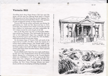
... System W Rae's Home Rae's Open Cut 3 Pages titled Victoria Hill. On one side is a sketch of W Rae's Home built in the early 1870's and Rae's Open Cut. Mentioned is a short history of Victoria Hill and the mine of Christopher Ballerstadt and his son Theodore. The remains of a 20 head crushing battery, which was originally the ten head crusher of the Little 180 Mine remains. It later became the twenty head New Chum Syncline Battery. Water became a problem and the New Chum Drainage Scheme was introduced and the cost of pumping ...3 Pages titled Victoria Hill. On one side is a sketch of W Rae's Home built in the early 1870's and Rae's Open Cut. Mentioned is a short history of Victoria Hill and the mine of Christopher Ballerstadt and his son Theodore. The remains of a 20 head crushing battery, which was originally the ten head crusher of the Little 180 Mine remains. It later became the twenty head New Chum Syncline Battery. Water became a problem and the New Chum Drainage Scheme was introduced and the cost of pumping and bailing was shared between the mines.bendigo, history, long gully history group, the long gully history group - victoria hill, gold mines hotel, christopher ballerstedt, theodore ballerstadt, ballerstadt's open cut, lansell's 180 mine, little 180 mine, new chum syncline battery, victoria reef quartz mining co, victoria quartz, new chum drainage system, w rae's home, rae's open cut -
 The Beechworth Burke Museum
Photograph - Photograph - Reproduction
... system. Due to the discovery of Gold in Rutherglen, Rutherglen developed into a community in its own right, possessing a population of 6600 by December 1860 and developed into a municipality in 1862. The Great Southern Mine depicted in this photograph required the use of a range of modern technologies, including the hydraulic pumps, in order to reach gold. ...system. Due to the discovery of Gold in Rutherglen, Rutherglen developed into a community in its own right, possessing a population of 6600 by December 1860 and developed into a municipality in 1862. The Great Southern Mine depicted in this photograph required the use of a range of modern technologies, including the hydraulic pumps, in order to reach gold. ...This photograph depicts the Great Southern Mine located in Rutherglen as it was during the 1900. After the initial Gold Rush of 1853-1854, Gold was discovered deeper under the surface of the earth in the 1860 after the discovery of another deep lead system. Due to the discovery of Gold in Rutherglen, Rutherglen developed into a community in its own right, possessing a population of 6600 by December 1860 and developed into a municipality in 1862. The Great Southern Mine depicted in this photograph required the use of a range of modern technologies, including the hydraulic pumps, in order to reach gold. This photo depicts the mining operations as they were undertaken around the turn of the century.The search for gold is ingrained into the history of Victoria and therefore, images like this one which portray a modern mining operation undertaken in the 1860s, can reveal important information for society and technology for the date when the photograph was taken. This image is of important historical significance for its ability to convey information about the methods used to extract gold in 1900. It is significant as most mining operations around the region, particularly earlier on in the period, used different technologies such as water races. This image is important for current research into the history of Rutherglen more generally, a town which developed singlehandedly due to the discovery of minerals and mining, as depicted here in this photograph, thus indicating an element of social significance as well as historic. The Beechworth Burke Museum has additional images relating to mining and Rutherglen which can be analysed and studied alongside images like this one.A black and white rectangular photograph printed on matte photographic paper.Reverse: $ 3.00 19972503 / a02503 / Great Southern Mine Rutherglen 1900rutherglen mine, rutherglen, great southern mine, beechworth, mine, mining, post goldrush, victoria, gold, 1860s, sluicing, hydrolic sluicing -
 Eltham District Historical Society Inc
Document - Property Binder, 1184 Main Road, Eltham
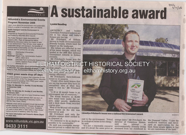
... French doors open from the living area to a deck, concealing the treatment system for all waste water. This is pumped through sub-soil drippers to the indigenous garden beds and no-dig vegetable patch. ...French doors open from the living area to a deck, concealing the treatment system for all waste water. This is pumped through sub-soil drippers to the indigenous garden beds and no-dig vegetable patch. ...Newspaper article: A sustainable award, Diamond Valley Leader, 1 November2006, Architect and building Llewellyn Pritchard won resource Efficiency Housing Award, finalist in HIA Greensmart Building of the Year Award. House – Environmental Leader (Published: Nillumbik Now and Then / Marguerite Marshall 2008; photographs Alan King with Marguerite Marshall.; p186) In 2006 environmental awareness was mushrooming in the community, which is reflected in the award-winning house at Main Road near Wattletree Road, Eltham. At first sight, the building appears a mix of a classic Eltham mud-brick house and an avant-garde building style. The crown of solar panels stretching along the width of the curved roof, indicates that this is no ordinary house. In fact it signals a new building trend of minimal impact on the environment. Yet it utilises the environment with high technical expertise to achieve comfort and cut running and maintenance costs. In recognition of this, its designer/builder, Conscious Homes, won the 2006 National HIA Greensmart Resource Efficiency Award. For Conscious Homes director, Llewellyn Pritchard, this house reflects a philosophy, strengthened by his connection with Aboriginal culture, through his foster siblings. Pritchard believes the sustainable way indigenous Australians lived and their spiritual connection with land, demonstrates how humanity is part of the ecology. His interest in environmental design stemmed from growing up in bushy Eltham Shire, with its mud-brick tradition. This was followed by studying Architecture at RMIT in the early 1980s, and learning about passive solar design. Pritchard says this house demonstrates that environmental sustainability is not about sacrifice, but about exceptional levels of occupant comfort, savings in running costs and modern fittings and appliances.1 The solar panels on the north roofs are intentionally obvious to make a statement about what the building is doing. But inside the systems are hidden and interactive with conventional services, such as the underground water tank. The house is water and energy self-sufficient and at 12 squares is much smaller than conventional houses, to minimise resources. Yet it accommodates his family of four with three bedrooms, a living/dining and kitchen area and a bathroom/laundry. Importantly the building is designed to last hundreds of years, by being able to be modified as the need arises, such as for commercial use. In this way the structure minimises its environmental impact. The solid double mud-brick walls (which are insulated) include steel beams and supporting frame, allowing the future removal or alteration of any section. The materials are local, recycled and of low toxicity where possible.2 Inside and out, the mud-brick is rendered and sealed with a combination of cement and sand and a mud-based coating in a soft golden hue increases its life. Inside, the golden-brown timber is plantation Mountain Ash and the concrete floors throughout – of local stone aggregate with a clear seal – have a natural looking random stone appearance. The house sustains a stable temperature of around 20 degrees, assisted by the concrete slab floor. The many large double-glazed windows and highlights (windows set high on walls) provide cross-flow ventilation. The north-facing living area maximises heating from the lower winter sun and is cooler in summer, because the sun is higher. Heating comes from a solar hydronic slab system. All appliances and fittings are high efficiency energy or water rated. Appliances in the timber kitchen include a gas stove and a dishwasher, using the building’s own power and water. French doors open from the living area to a deck, concealing the treatment system for all waste water. This is pumped through sub-soil drippers to the indigenous garden beds and no-dig vegetable patch. Below the carport is the 80,000-litre rainwater tank and at the back, the boiler room houses the solar boiler, water tank access, domestic water supply pump, filter gear and hydronic slab heating controls. The solar system is backed up with gas, which is needed to heat water only in winter. Gas used is less than one quarter of that for an average home with ducted heating. Excess power is fed back to the grid and the building uses about one quarter of the mains electricity of an average home. Other local builders have followed Pritchard’s lead in resource efficiency for minimal environmental impact.main road, eltham, businesses, llewellyn pritchard, hia greensmart building of the year award., efficiency housing award, conscious homes australia pty ltd -
 Eltham District Historical Society Inc
Book, The Melbourne & Metropolitan Board of Works Water Supply, Sewerage, etc. Photographic Views, 1908
... systems. This is now is a rare copy. mmbw weirs dams & pumping stations reservoirs aqueducts Nil Photographic images, landscape dimensions, hardboard cover, grey green colour The Melbourne & Metropolitan Board of Works Water Supply, Sewerage, etc. ...In 1908 the Melbourne & Metropolitan board of Works published this book to illustrate its many constructions to provide Melbourne with its reticulated water and sewerage systems.This is now is a rare copy.Photographic images, landscape dimensions, hardboard cover, grey green colour Nilmmbw, weirs, dams & pumping stations, reservoirs, aqueducts -
 Melbourne Water
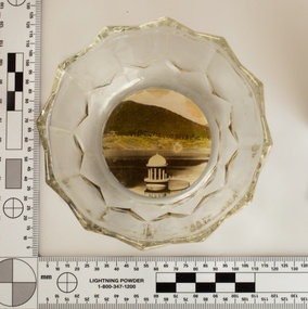
Souvenir confectionery bowl, 1930s-40s
... pumping houses and reservoir outlet towers. The reservoir gardens and picnic areas were landscaped with ornamental stonework, exotic trees, decorative flower beds, fern glades pools and rose gardens. All features of the water supply system...pumping houses and reservoir outlet towers. The reservoir gardens and picnic areas were landscaped with ornamental stonework, exotic trees, decorative flower beds, fern glades pools and rose gardens. All features of the water supply system ...Melbourne Water inherited many of its water assets, such as reservoirs from its predecessor the Melbourne Metropolitan Board of Works (MMBW). They have served the organisation well and have long been celebrated for both their natural beauty and engineering ingenuity. In the nineteenth century Victoria’s fundamental need for water infrastructure went beyond merely functional solutions and reflected the English ideal of the romance and beauty that was embodied in expanses of water. The MMBW further enhanced this notion by incorporating beauty and function in to the Classical and Italianate designs of its infrastructure such as pumping houses and reservoir outlet towers. The reservoir gardens and picnic areas were landscaped with ornamental stonework, exotic trees, decorative flower beds, fern glades pools and rose gardens. All features of the water supply system became widely celebrated as beauty spots that continue to be very popular to this day with tourists and locals alike. This souvenir is a product of that flourishing tourist trade. These water supply sites continue to enhance Melbourne’s charm and liveability and are now recognised as places of cultural and historic significance. This souvenir item has been curated by Melbourne Water as it represents an important historical aspect of the organisation by demonstrating the popularity of its water asset sites as recreational places and tourist attractions, and although these sites are functional parts of the water supply system, they were also designed to be enjoyed by the public both aesthetically and recreationally. Clear glass flower shaped 'depression ware' confectionery bowl, with photographic image of Maroondah Reservoir outlet tower on basemelbourne metropolitan board of works, mmbw, maroondah reservoir, melbourne water, scenic view, souvenir, glass bowl -
 Melbourne Water
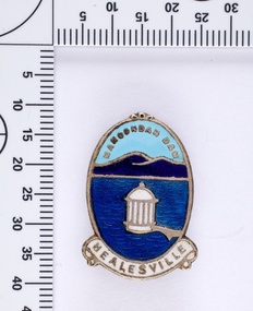
Souvenir lapel pin/brooch Maroondah Dam, 1960s/70s
... pumping houses and reservoir outlet towers. The reservoir gardens and picnic areas were landscaped with ornamental stonework, exotic trees, decorative flower beds, fern glads pools and rose gardens. All features of the water supply system...pumping houses and reservoir outlet towers. The reservoir gardens and picnic areas were landscaped with ornamental stonework, exotic trees, decorative flower beds, fern glads pools and rose gardens. All features of the water supply system ...Melbourne Water inherited many of its water assets, such as reservoirs from its predecessor the Melbourne Metropolitan Board of Works (MMBW). They have served the organisation well and have long been celebrated for both their natural beauty and engineering ingenuity. In the nineteenth century Victoria’s fundamental need for water infrastructure went beyond merely functional solutions and reflected the English ideal of the romance and beauty that was embodied in expanses of water. The MMBW further enhanced this notion by incorporating beauty and function in to the Classical and Italianate designs of its infrastructure such as pumping houses and reservoir outlet towers. The reservoir gardens and picnic areas were landscaped with ornamental stonework, exotic trees, decorative flower beds, fern glads pools and rose gardens. All features of the water supply system became widely celebrated as beauty spots that continue to be very popular to this day with tourists and locals alike. This souvenir is a product of that flourishing tourist trade. These water supply sites continue to enhance Melbourne’s charm and liveability and are now recognised as places of cultural and historic significance. This souvenir item has been curated by Melbourne Water as it represents an important historical aspect of the organisation by demonstrating the popularity of its water asset sites as recreational places and tourist attractions, and although these sites are functional parts of the water supply system, they were also designed to be enjoyed by the public both aesthetically and recreationally. Blue enamel and metal lapel pin/brooch depicting Maroondah Reservoir and outlet tower. Oval shaped with words 'Maroondah Dam' at the top and a ribbon banner containing 'Healesville' at the bottom. Maroondah Dam. Healesvillemelbourne metropolitan board of works, mmbw, maroondah reservoir, melbourne water, scenic view, souvenir, lapel pin, brooch -
 Melbourne Water
Photographic View Book, The Melbourne & Metropolitan Board of Works - Water Supply, Sewerage etc. ...Photographic Views, 1908
... system. A treatment farm was built at Werribee and a pumping station was built at Spotswood (now the site of the Scienceworks Museum) to send the city's waste to Werribee. ...system. A treatment farm was built at Werribee and a pumping station was built at Spotswood (now the site of the Scienceworks Museum) to send the city's waste to Werribee. ...In 1891 The Melbourne and Metropolitan Board of Works (MMBW) was formed and became responsible for Melbourne's water supply. Melbourne had grown to a city of half a million people. To provide water to this rapidly growing city (especially the eastern suburbs), and to supplement the 1857 Yan Yean Reservoir, Melbourne's first water supply, the Watts River (near Healesville) was tapped. It supplied water to Melbourne, via the Maroondah aqueduct. In May 1892 the MMBW's first engineer-in-chief, Mr William Thwaites began construction on Melbourne's sewerage system. A treatment farm was built at Werribee and a pumping station was built at Spotswood (now the site of the Scienceworks Museum) to send the city's waste to Werribee. The first Melbourne homes were connected to the sewerage system in 1897. This book showcases the MMBW's infrastructure achievements and documents costs, requirements and key personnel involved in the development of the water supply and sewerage schemes.The introduction states "The water supply sources and headworks are in many cases situated in remote places and the sewerage works are chiefly underground. The Board has therefore resolved that these photographs of some of the scenes and works should be collected and bound for general information. August 1908" This book is in excellent condition and provides a detailed insight into the previous 17 years of work and the Board personnel of the MMBW leading up to 1908. It is of historical importance to the history of Melbourne for the photographic documents of places that were not generally open to the public, and for Melbourne Water in its detailed history of the MMBW in the early twentieth century. Photographic view book with hard khaki coloured cardboard cover and blue fabric binding. 120 Pages. Glossy paper with black and white plates and text about the MMBW, and scenic views and places of interest in association with the MMBW. The Melbourne & Metropolitan Board of Works - Water Supply, Sewerage etc. ...Photographic Views...mmbw, board members, sewerage, water supply, historic views, photographs -
 Melbourne Water
Souvenir tea caddy spoon "Tea Time", Early 1960s
... pumping houses and reservoir outlet towers. The reservoir gardens and picnic areas were landscaped with ornamental stonework, exotic trees, decorative flower beds, fern glads pools and rose gardens. All features of the water supply system...pumping houses and reservoir outlet towers. The reservoir gardens and picnic areas were landscaped with ornamental stonework, exotic trees, decorative flower beds, fern glads pools and rose gardens. All features of the water supply system ...Melbourne Water inherited many of its water assets, such as reservoirs from its predecessor the Melbourne Metropolitan Board of Works (MMBW). They have served the organisation well and have long been celebrated for both their natural beauty and engineering ingenuity. In the nineteenth century Victoria’s fundamental need for water infrastructure went beyond merely functional solutions and reflected the English ideal of the romance and beauty that was embodied in expanses of water. The MMBW further enhanced this notion by incorporating beauty and function in to the Classical and Italianate designs of its infrastructure such as pumping houses and reservoir outlet towers. The reservoir gardens and picnic areas were landscaped with ornamental stonework, exotic trees, decorative flower beds, fern glads pools and rose gardens. All features of the water supply system became widely celebrated as beauty spots that continue to be very popular to this day with tourists and locals alike. This souvenir is a product of that flourishing tourist trade. These water supply sites continue to enhance Melbourne’s charm and liveability and are now recognised as places of cultural and historic significance This souvenir item has been curated by Melbourne Water as it represents an important historical aspect of the organisation by demonstrating the popularity of its water asset sites as recreational places and tourist attractions, and although these sites are functional parts of the water supply system, they were also designed to be enjoyed by the public both aesthetically and recreationally. Tea caddy spoon with clock face engraved showing 4pm on round spoon, tea pot shaped handle with enamel scenic view badge saying 'Healesville' ( depicting Maroondah Reservoir outlet tower). Tea caddy spoon box labelled 'Fine Silverware by Stokes'Stokes and Sons Stokes & Sons logo (Star with S and boomerang) EG. No. 15733melbourne metropolitan board of works, mmbw, maroondah reservoir, melbourne water, scenic view, souvenir, tea caddy spoon -
 Bendigo Historical Society Inc.
Document - KANGAROO FLAT GOLD MINE COLLECTION: ENGINEERING FEASIBILITY STUDY CENTRAL DEBORAH GOLD MINE DEWATERING
... Areas discussed in study: the mine dewatering proposal; minewater quality, minewater disposal options and criteria; minewater volumes; volume of workings; volume of fissures; groundwater inflow; pump equipment; wastewater disposal options; discharge to sewerage system; discharge to Bendigo Creek; treatment and odour control; treatment of minewater; foul air treatment; proposed treatment systerm; summary of conclusions....Areas discussed in study: the mine dewatering proposal; minewater quality, minewater disposal options and criteria; minewater volumes; volume of workings; volume of fissures; groundwater inflow; pump equipment; wastewater disposal options; discharge to sewerage system; discharge to Bendigo Creek; treatment and odour control; treatment of minewater; foul air treatment; proposed treatment systerm; summary of conclusions. ...Engineering feasability study, 24 pages and diagrams dated November 4th 1982, to dewater Central Deborah Gold Mine. On front cover 'Bendigo Mining NL, Central Deborah Goldmine Dewatering, Engineering Feasibility Study, Caldwell, Connell Engineers Pty Ltd.' 'Draft' watermark on each page. Areas discussed in study: the mine dewatering proposal; minewater quality, minewater disposal options and criteria; minewater volumes; volume of workings; volume of fissures; groundwater inflow; pump equipment; wastewater disposal options; discharge to sewerage system; discharge to Bendigo Creek; treatment and odour control; treatment of minewater; foul air treatment; proposed treatment systerm; summary of conclusions.bendigo, mining, central deborah gold mine -
 Bendigo Historical Society Inc.
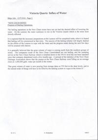
Document - DRAINAGE PROBLEMS - VICTORIA QUARTZ INFLUX OF WATER
... pumps at the New Chum Railway were lifting on anaverage close on 1,000,000 galls of water per month in the winter. That great volume of water is now pouring from storage dams at 550 feet to the deep levels, and in the natural order of things will have to be lifted by the tanking system in vogue at the mines N.' ...pumps at the New Chum Railway were lifting on anaverage close on 1,000,000 galls of water per month in the winter. That great volume of water is now pouring from storage dams at 550 feet to the deep levels, and in the natural order of things will have to be lifted by the tanking system in vogue at the mines N.' ...Handwritten copy of a report in the Bendigo Advertiser 12/7/1910 Page 2. New Chum Mines. Progress of Bailing Operations. The bailing operations at the New Chum mines have not yet had the desired effect of lowering the water. On the contrary the water continues to rise in the Victoria Quartz which is the mine most directly affected. It is expected that the necessary preparations at the Lazarus will be completed today when it is hoped that bailing will be commenced at that mine. The success of the bailing scheme will largely depend on the efforts of the Lazarus to cope with the water and the progress made during the next few days will be awaited with interest. It is generally believed that the great volume of water is coming north from the southern group of mines. The companies south of the New Chum Consolidated are not bailing, and the pumping service at the New Chum Railway which is installed down to the 550 ft. level has not been operated since that company abandoned work a few months ago. A perusal of the statistics of the New Chum Drainage Association shows that the pumps at the New Chum Railway were lifting on anaverage close on 1,000,000 galls of water per month in the winter. That great volume of water is now pouring from storage dams at 550 feet to the deep levels, and in the natural order of things will have to be lifted by the tanking system in vogue at the mines N.' Document from Albert Richardson Collection of mining history.document, gold, drainage problems, new chum drainage association, victoria quartz influx of water, bendigo advertiser 12/7/1910 page 2, victoria quartz, lazarus, new chum consolidated, new chum railway, new chum drainage association -
 Bendigo Historical Society Inc.
Document - STATE RIVERS AND WATER SUPPLY COMMISSION VICTORIA : CENTRAL PLANT WORKSHOPS
... System. Central Plant Workshops. State Rivers and Water Supply Commission of Victoria. Brochure titled 'Central Plant Workshops'. Double-sided, three pages on each. Information about the workshops (CPW for short) and the setting up of the Bendigo site from 1946. There is a map of the layout of the site, and information given under the following headings - Central Plant Workshops, Work of the CPW, Meter Wheels, Pump ...State Rivers and Water Supply Commission of Victoria. Brochure titled 'Central Plant Workshops'. Double-sided, three pages on each. Information about the workshops (CPW for short) and the setting up of the Bendigo site from 1946. There is a map of the layout of the site, and information given under the following headings - Central Plant Workshops, Work of the CPW, Meter Wheels, Pump Station Equipment, Steel Fabrication, Precast Concrete, and the Area and its Equipment. The brochure is dated June, 1968.state infrastructure, water supply, coliban system, state rivers and water supply commission of victoria. coliban system. central plant workshops. -
 Bendigo Historical Society Inc.
Document - STATE RIVERS AND WATER SUPPLY COMMISSION : EPPALOCK PROJECT - CONSTRUCTION
... System. Eppalock. State Rivers and Water Supply Commission headed six page document, stapled. Subtitled: ' Eppalock Project - Construction. Some Technical Notes.' Information typed under subheadings: Dam, Embankment, Spillways, Outlet works, proposed hydraulic driven pumps, road deviations. ...State Rivers and Water Supply Commission headed six page document, stapled. Subtitled: ' Eppalock Project - Construction. Some Technical Notes.' Information typed under subheadings: Dam, Embankment, Spillways, Outlet works, proposed hydraulic driven pumps, road deviations. Undated.state infrastructure, water supply, coliban system, state rivers and water supply commission. coliban system. eppalock. -
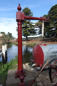 Flagstaff Hill Maritime Museum and Village
Functional object - Water standpipe, Langlands Bros. & Co, 1880-1893
... pumped from springs at Cannon Hill through the connected pipeline to the standpipe, then distributed to households via horse and cart. Each of the licenced cart drivers were compelled by Council regulations to keep their carts full from sunset to sunrise, ready to cart water to outbreaks of fire. They received a fee for this service. In 1893 the town installed a water supply, sourced from the Merri River, stored in a reservoir basin and tower in north Liebig Street, and distributed throughout the town in a system...pumped from springs at Cannon Hill through the connected pipeline to the standpipe, then distributed to households via horse and cart. Each of the licenced cart drivers were compelled by Council regulations to keep their carts full from sunset to sunrise, ready to cart water to outbreaks of fire. They received a fee for this service. In 1893 the town installed a water supply, sourced from the Merri River, stored in a reservoir basin and tower in north Liebig Street, and distributed throughout the town in a system ...This water standpipe is believed to be the only one of its kind in working order. It was originally located in Warrnambool, on the hillside at the corner of Mickle Crescent and Banyan Street, providing water for the Chinese Market Gardens below, on the flats. It was removed from this location on May 2nd, 1979, with the intention to relocate it at the new Flagstaff Hill Maritime Museum & Village. The standpipe lay in storage for years until the Warrnambool Company, Chemblast, offered to restore it for use as a working display. The display was officially opened on March 31, 2014. The water from the adjacent lake is drawn out with a hand operated water pump, and goes up into the standpipe, where flows through the canvas hose and into the top of the Furphy Farm Water Cart. The display is a visual acknowledgement of the years served by Flagstaff Hill volunteer and Friends of Flagstaff Hill Chairperson, Bob Crossman. Warrnambool’s early settlers had no water supply prior to the mid-1850s. They relied on rain water tanks, domestic wells and springs. The town experienced a huge, destructive fire in William Bateman Jnr. & Co.’s large produce store in November 1856, which highlighted the need for both a fire brigade and a good supply of water. In 1863 a volunteer fire brigade was established. In August 1880 the town celebrated the installation of its first water standpipe on the corner of Liebig and Timor streets. The water was pumped from springs at Cannon Hill through the connected pipeline to the standpipe, then distributed to households via horse and cart. Each of the licenced cart drivers were compelled by Council regulations to keep their carts full from sunset to sunrise, ready to cart water to outbreaks of fire. They received a fee for this service. In 1893 the town installed a water supply, sourced from the Merri River, stored in a reservoir basin and tower in north Liebig Street, and distributed throughout the town in a system of pipes. By late 1939 a reticulated supply was installed, with the water piped in under the Otway Scheme. Standpipes are still used in modern times in rural and remote areas for homes, farms, stock, agriculture and firefighting. Many commercial or government owned standpipes are metered, charging a fee for the quantities of water supplied. This water standpipe was made by Langlands Foundry Co. Limited, Melbourne, which was establish in 1842. It was Melbourne’s first foundry and iron shipbuilder, and one of the largest employers in Victoria at the time. Langlands was known for its high quality workmanship and wide range of goods for mining, engineering, marine, railway and other industrial uses. The company made the first cast bell, the first lamp posts in the colony, and the boiler for the first Australian train. In the 1860s it produced cast iron pipes for the Board of Works, which laid the pipes for Melbourne’s first reticulated water supply. The firm was bought by Austral Otis Co. in 1897.This water standpipe is significant historically as it is believed to be the only one of its type in working condition. The standpipe is significant for being manufactured by early colonial firm Langlands Foundry of Melbourne, which was known for high quality, cast iron products. The firm made the boiler for the first Australian train, assembled the first Australian paddle steamer and made the first Australian cast bell and lamp posts. Langlands was one of the largest employers in Victoria at the time. The standpipe is significant historically as it represents the evolution of water supply services in Australia. Standpipe; vertical cast iron water pipe, painted crimson, fixed in position, tapering inward from the round base to the rectangular joint near the finial on top. A hexagonal pipe extends at right angles from the joint, with an outlet fitting and flow-controlling wheel on the end. A length of canvas hose hangs from the outlet fitting. Inscriptions are on one face of the joint. The standpipe was made by Langlands Foundry Company of Melbourne. Embossed “LANGLANDS FOUNDRY CO. / LIMITED / ENGINEERS / MELBOURNE”warrnambool, flagstaff hill maritime museum, maritime museum, shipwreck coast, flagstaff hill maritime village, great ocean road, flagstaff hill, standpipe, stand-pipe, water standpipe, fire standpipe, firefighting equipment, water supply equipment, chinese market gardens, banyan street, liebig street, water tower, bateman’s fire, working display, water supply, town water, rural water, reticulated water, cannon hill spring, merri river, otway water, water carters, horse and cart water supply, volunteer fire brigade, langlands foundry, early melbourne, iron works, bob crossman, late 19th century water supply