Showing 413 items matching quarry road
-
 Glenelg Shire Council Cultural Collection
Photograph - Photograph - Cape Grant Quarry, 27/08/1953
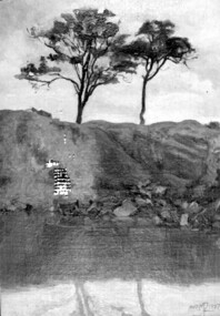
... Black and white photo of section of Cape Grant quarry road... quarry road. Two men on left watching man operate bulldozer ...Port of Portland Authority ArchivesBack: Purple PHT stampport of portland archives, cape grant quarry -
Glenelg Shire Council Cultural Collection
Photograph - Photograph - Cape Grant Quarry, 08/07/1953
... Black and white photo showing Cape Grant quarry road... Cliff Street Portland great-ocean-road Photograph - Cape Grant ...Port of Portland Authority ArchivesBack: Purple PHT stampport of portland archives, cape grant quarry -
 Surrey Hills Historical Society Collection
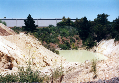
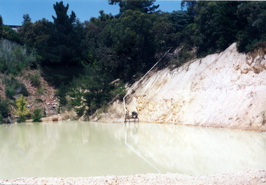
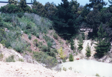
Painting, Muriel Pornitz (Pornett), "The old quarry" by Muriel Pornitz, 1927
... grovedale road quarry... and cartoonist. She died in 1982. painting grovedale road quarry quarry ...The waterbody was the site of a quarry that existed between Grovedale Road and James Street, Surrey Hills on land owned by J B Maling (senior). Clay from it was used to make bricks for local houses. The quarry became a hazard and after several drownings was filled in. The Grovedale Park now occupies the site. Muriel Hedwig Lucy Pornitz, also known as Muriel Pornett, lived locally. She was born in Melbourne in 1894 and studied at the South Australian School of Arts & Crafts in 1911 under James Ashton and Fred Britton, and at the Australian School of Etching in Sydney. She was also an illustrator and cartoonist. She died in 1982.A small oil painting on canvas board in a dark wood frame of a water body with a clay bank behind and 2 trees above the bank. Lower front right hand corner: "AUST. M P 1927" On the rear upper edge, in ink on badly degraded brown paper backing: " "The Old Quarry" Surrey Hills, Melb." / [Second line of writing is illegible.] A label is stuck to the middle section of the paper backing. It indicates that the painting was framed by Toska Art Studio (N. Cl Colliver, Proprietor) of wyndham Street, Shepparton. Lower rear edge, in ink on badly degraded brown paper backing: "by / Muriel ...... / "Darnok", / 22 Grovedale Rd / Surrey Hills, Melb" painting, grovedale road quarry, quarry, grovedale road park, john butler maling (snr), surrey hills, muriel pornitz, muriel pornett -
 Surrey Hills Historical Society Collection
Photograph, Alice Sedgman with grand-daughter
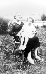
... grovedale road quarry... grovedale road quarry croydon road grovedale road midwife nurse ...Alice Sedgman (nee Percy) – 1873-1945 Alice was born in Maldon in 1873, one of 9 children of William Henry Percy and his wife Unice King. Alice married Francis Sedgman, occupation painter, in 1896 and they went on to have 8 children, all born in Kew or Hawthorn before the family came to Surrey Hills. The electoral roll for 1903 shows the family living in Liddiard Street in Hawthorn and Alice’s occupation is given as home duties. It is the same in 1909 when they are living at 65 Croydon Road, Surrey Hills and continues to be thus listed in all electoral rolls until the 1943 edition, just before her death. However Mrs Sedgman was also an active nurse and midwife who often worked with Dr James Blakie, who had arrived in Surrey Hills in 1905, initially practicing from 171 Union Road and then in 1913 moving across the road to the purpose-built home and practice at 174 Union Road, now Surrey Hills Medical Centre. At this period most babies were born at home. Sometime after 1931 Alice and Francis Sedgman moved from 65 Croydon Road into 10 Grovedale Road and lived with their son Francis William Sedgman and his family for the remainder of their lives. The photo shows Mrs Alice Sedgman in early 1930s with grand-daughter Joy in the garden of her son. Behind her can be seen the fenced 'quarry' which is now parkland. Alice died in 1945 and Francis in 1951. They are buried in Boroondara Cemetery along with an infant son Clarence and daughter Marjorie. Alice Sedgman was one of the area's early midwives when women for the main part delivered their children at home.A black and white photograph of a lady sitting in a cane chair holding a young girl on her knee.mr francis william sedgman, mr francis sedgman, mrs alice sedgman, miss alice percy, miss joy sedgman, mrs joy scanlon, grovedale road park, grovedale road quarry, croydon road, grovedale road, midwife, nurse -
 Stawell Historical Society Inc
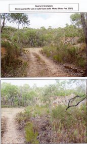
Photograph, Track into the Grampians Quarry for Stone for the Lafe Fyan Emabankment 2017 -- 2 Photos -- Coloured
... Two colour photographs of Track into Quarry Road Grampians....Two colour photographs of Track into Quarry Road Grampians ...Two colour photographs of Track into Quarry Road Grampians.stawell -
 Stawell Historical Society Inc
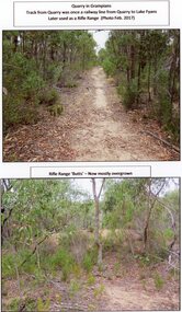
Photograph, A Track into Grampians Quarry -- Previously a Railway Line & Rifle Range 2017 -- 2 Photos -- Coloured
... Two colour photographs of Track into Quarry Road Grampians... photographs of Track into Quarry Road Grampians. Once Rail Line Later ...Two colour photographs of Track into Quarry Road Grampians. Once Rail Line Later used as rifle range stawell -
Glenelg Shire Council Cultural Collection
Photograph - Photograph - Cape Grant Quarry, 04/05/1954
... Black and white photo of Cape Grant looking north. Quarry... north. Quarry access road in foreground. Front: Back- Purple PHT ...Port of Portland Authority ArchivesFront: Back- Purple PHT stampport of portland -
Glenelg Shire Council Cultural Collection
Photograph - Photograph - Cape Grant Quarry, 09/01/1959
... Black and white photo of Cape Grant quarry. Road around.... Road around edge of bottom section of quarry - becomes 1st ...Port of Portland Authority ArchivesBack: Purple PHT stamp. '9 JAN 1959'port of portland archives, cape grant quarry -
Glenelg Shire Council Cultural Collection
Photograph - Photograph - Blacknose Quarry, 29/08/1952
... Front: BLACKNOSE QUARRY ACCESS ROAD 29/8/52 - printed... Quarry Photograph Black and white photo of the access road under ...Port of Portland Authority ArchivesFront: BLACKNOSE QUARRY ACCESS ROAD 29/8/52 - printed in bottom frame Back: Purple PHT stampport of portland archives, blacknose quarry -
Glenelg Shire Council Cultural Collection
Film - Film - Harbour Construction 1950s-1960s, n.d
... Levelling railway approach Fawthrop Lagoon Quarry Road - Quarry... Quarry Road - Quarry gates *denotes footage of interest Front ...Port of Portland AuthorityFront: Harbour Construction/ Portland (B & W) (blue pen and white sticky tape, top of reel)port of portland archives, film -
Whitehorse Historical Society Inc.
Document, Andreas Fritsch, 1992
... His quarry was between Burwood Road and Mahoneys Reserve...History and maps of the brick quarry opened by Andreas... in Nunawading in 1856. His quarry was between Burwood Road and Mahoneys ...History and maps of the brick quarry opened by Andreas Fritsch in Nunawading in 1856.History and maps of the brick quarry opened by Andreas Fritsch in Nunawading in 1856. His quarry was between Burwood Road and Mahoneys Reserve, enclosed with a letter from Geoff Ford, historian and pottery collector to Mrs B. Gray. Information on history taken from Niall Brennan's 'History of Nunawading'.History and maps of the brick quarry opened by Andreas Fritsch in Nunawading in 1856. clay, fritsch, andreas, ford, geoff, gray, beryl, pottery -
Whitehorse Historical Society Inc.
Article, Make-over for ex-quarry site, 2005
... A development has been planned for the old quarry site... Road. Quarries Brick Industries Limited Middleborough Road ...A development has been planned for the old quarry site on Middleborough Road.A development has been planned for the old quarry site on Middleborough Road.A development has been planned for the old quarry site on Middleborough Road.quarries, brick industries limited, middleborough road, burwood east, brickworks -
Glenelg Shire Council Cultural Collection
Photograph - Photograph - Cape Grant Quarry, 09/07/1954
... . Road going down to floor of quarry, 2 trucks and crane on road..., looking south. Road going down to floor of quarry, 2 trucks ...Port of Portland Authority ArchivesBack: Purple PHT stampport of portland archives, cape grant quarry -
 Whitehorse Historical Society Inc.
Photograph, Daniel Robertson Australia, 2000
... Brickworks, looking East toward Norcal Road. Quarry located behind..., looking East toward Norcal Road. Quarry located behind present ...Photo taken of old Quarry at the Daniel Robertson Brickworks, looking East toward Norcal Road. Quarry located behind present Brickwork Buildings.robertson, daniel, brickworks, quarries, station street, nunawading, nos. 58 to 74 -
 Whitehorse Historical Society Inc.
Photograph, Daniel Robertson Australia, 2000
... Brickworks, looking South-East towards Norcal Road. Quarry located..., looking South-East towards Norcal Road. Quarry located behind ...Photo taken of old Quarry at the Daniel Robertson Brickworks, looking South-East towards Norcal Road. Quarry located behind present Brickwork Buildings.robertson, daniel, station street, nunawading, nos. 58 to 74, brickworks, quarries -
 Whitehorse Historical Society Inc.
Photograph, Daniel Robertson Australia, 2000
... Brickworks, looking South-East towards Norcal Road. Quarry located..., looking South-East towards Norcal Road. Quarry located behind ...Photo taken of old Quarry at the Daniel Robertson Brickworks, looking South-East towards Norcal Road. Quarry located behind present Brickwork Buildings.robertson, daniel, brickworks, quarries, station street, nunawading, nos. 58 to 74 -
Whitehorse Historical Society Inc.
Article, New bid for cinema, 2005
... Article on development plans for former quarry site... on development plans for former quarry site on Middleborough Road ...Article on development plans for former quarry site on Middleborough Road for a cinema complex and discount department store.Article on development plans for former quarry site on Middleborough Road for a cinema complex and discount department store.Article on development plans for former quarry site on Middleborough Road for a cinema complex and discount department store.middleborough road, burwood east, reading entertainment australia pty ltd, burwood heights, commercial development, land subdivision -
Glenelg Shire Council Cultural Collection
Photograph - Photograph - Cape Grant Quarry, n.d
... ; Ute on road, first level, quarry master second level.... on floor of quarry; Ute on road, first level, quarry master second ...Port of Portland Authority Archivesport of portland archives, cape grant quarry -
 Ringwood and District Historical Society
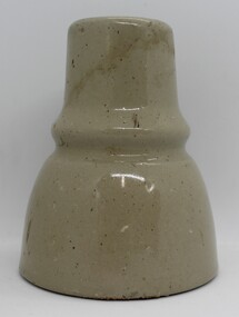
Ceramic - Insulators, Insulator factory in East Ringwood, Two ceramic insulators made in East Ringwood from local clay - c.1900, c. 1900
... corner of Velma Grove and Mount Dandenong Road approx. Quarrying... Road Ringwood North melbourne Insulators Ceramic Two ceramic ...The insulator factory and ovens were located on the SW corner of Velma Grove and Mount Dandenong Road approx. Quarrying for clay was done in the nearby area. Refer photographs of the factory.Two ceramic insulators made in East Ringwood from local clay. Colour grey. Conical with indentation in middle for wires. There is a second 'skirt' inside to enhance insulating performance. The inner hole is threaded. -
Glenelg Shire Council Cultural Collection
Photograph - Photograph - Portland Harbour, Main Breakwater Construction, n.d
... under construction. Main Breakwater. Battery Point, road... Breakwater. Battery Point, road to quarry , taken looking towards ...Port of Portland Authority Archivesport of portland archives, harbour construction, wharf, battery point -
Glenelg Shire Council Cultural Collection
Photograph - Photograph - Cape Grant Quarry, 09/01/1959
... , looking towards the road going up out of the quarry. Bucket... Grant quarry, looking towards the road going up out ...Port of Portland Authority ArchivesBack: Purple PHT stamp '9 JAN 1959' '9/1/59 - pencil, top leftport of portland archives, cape grant quarry -
 Ballarat Heritage Services
Newspaper - Newspaper article, Newsclipping Relating to Stonemason Julien Hardy
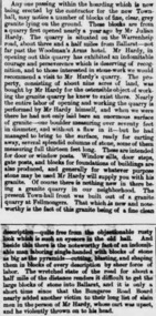
... established a stone quarry on the Melbourne Road, near Warrenheip... was born at Vire, Normandy, France. He established a stone quarry ...Julien Hardy was the first discoverer of gold at Happy Valley. A stonemason, he was born at Vire, Normandy, France. He established a stone quarry on the Melbourne Road, near Warrenheip (on the site now occupied by Shady Acres Caravan Park). From here, he quarried blocks that were used in the Ballarat Town Hall.Newsclippingjulien hardy, stonemason, gold, happy valley, shady acres, warrenheip, ballarat town hall -
 Kew Historical Society Inc
Photograph - Filling in the Outer Circle Railway cutting at East Kew, 1939
... Quarries' [located Keilor Road, North Essendon], one can see shops... truck, painted on the side with the name 'Fowler Quarries ...W.D. Vaughan (Kew's Civic Century, 1960, pp.195-6) quotes Council Minutes of 1938 and 1939 to record that: "After protracted negotiations between the Council, the Railways Department and the Tramways Board agreement was reached in June, 1938, for the filling of the railway cutting at the Harp Junction and shifting tram tracks to the High Street alignment ... The Outer Circle railway land from Princess Street to Park Crescent was purchased by the Kew Council in October, 1939, for 2,750 [pounds]. The land from Park Crescent to High Street was leased for 1 [pound] per annum. Considerable work was done in levelling the embankments to the original surface level."Important and rare photograph of the period, showing major works by Kew Council in Kew East working on a significant piece of urban infrastructure.Small, original black and white positive (photograph) showing workers and vehicles filling in the tracks of the former Outer Circle railway at East Kew. In the background is the metal bridge with brick piers, adjacent to the Harp Junction. The bridge crossed the cutting, linking the two parts of High Street. Behind the tip truck, painted on the side with the name 'Fowler Quarries' [located Keilor Road, North Essendon], one can see shops [including T.G. Garroway, Cash Grocer] in High Street. What appears to be the City of Kew Steamroller is immediately in front of the bridge. A group of passers-by watch from the bridge and from the road. Annotation in pencil on verso: "Filling in Outer Circle line at High St East Kew prior to straightening High St. (c. Feb 1930?)outer circle railway, railway cuttings, harp junction, high street -- kew east -
 Surrey Hills Historical Society Collection
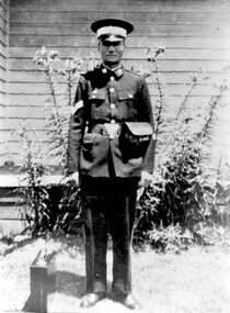
photograph, Mr Joseph George of 26 Scheele Street, air raid warden
... at the Quarry in Grovedale Road, in case they had to deal.... Joseph conducted his practical training sessions at the Quarry ...Mr Joseph George of 26 Scheele Street Pictured as an Air Raid Precautions Officer during the 1939 – 1945 war. ARP officers controlled the areas around their homes to check on tell-tale lights showing in the ‘brownout’ conditions and advising on the black-out of homes. Street lights were dimmed and screened downwards and Joseph’s daughter Marie remembered sewing black Italian cloth curtains to hang over the windows. Joseph taught adult first aid classes in local schools, church halls and at The Surrey Dive. Joseph conducted his practical training sessions at the Quarry in Grovedale Road, in case they had to deal with an emergency in such a site. Joseph (Joe) and wife Emily Ruth were English migrants; they bought their home in Scheele Street in 1919. Daughter Marie was born in 1914 when they are listed in the electoral roll at 'Hasland', Croydon Road, Surrey Hills; his occupation is given as a boilermaker. Emily (nee Sturgess) - d 15 November, 1960; buried Box Hill Cemetery - M-199A-0034 along with daughter Marie. Possible birth c Oct 1880, Birmingham (not confirmed); marriage to Joseph George c Jan 1905, Chesterfield, Derbyshire. The donor was his daughter, Marie, who was a school teacher and was on the staff at Chatham Primary School for a number of years. She died in February 1989.A black and white photograph of a man in uniform standing in a garden, with a small case beside him.(mr) joseph george, surrey hills, mont albert, scheele street, clothing and dress, uniforms, world war, 1939-1945, air raid wardens -
 Melton City Libraries
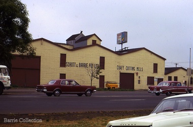
Photograph, Schutt and Barrie Pty Ltd Chaff Cutting Mills, Unknown
... association, the business was put on its feet. An empty quarry across... association, the business was put on its feet. An empty quarry across ...Mary nee Barrie Robinson (1907 –1999) writes c1980 about her father Charles Ernest Barrie of Darlingsford Melton (1871 – 1931) Extract copied from her handwritten story - My father was born in Ballarat in 1871. … commenced his working life with a team of bullocks and a chaffcutter in the St Arnaud district, a work the he became most success at and would continue in to the end of his life. He eventually became the owner of a chaff mill at Melton station with an access line to the railway. [1900] The Schutt & Barrie partnership Dad later became involved in a Chaff mill at West Footscray run by John Ralph Schutt who when he met Dad was a very sick man and had begged Dad to come into the business and help him. That began a very happy association, the business was put on its feet. An empty quarry across Geelong Road opposite the mill was purchased, the chaffcutters were set up in the quarry and that was the start of a very busy and prosperous period. A branch line was run into the mill. Dad spent some afternoons at the mill going by train, and spending some hours there at night, at the same time running the farm with full time help. Two full 8 horse teams were used to work the land, which meant early rising for the horses to be fed and harnessed ready for the men to commence the days work. Charlie Lowe and Murdock Davey were two of the men who worked for Dad in those years. The firm purchased a mill at Parwan and Dad spent a lot of time and energy getting it running to their satisfaction. Monday was the day he spent time there also round the district of Parwan and Balliang. He came to know many of the their names were well known in our household for many years. [1920] Later a flour mill was built beside the Chaff mill at West Footscray but it never thrived like the mill. The chaff mill had many loyal and good men employed there and there was never any trouble between men and management. Willie Walters and Miss Renyolds were some I remember, other names me, Joyce would be able to name them. [Sister of Mary born 1920] Schutt and Barrie Pty Ltd Chaff Cutting Mills Melton South sitelocal architecture, local identities, agriculture -
 Melton City Libraries
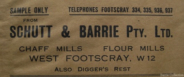
Document, 'Schutt and Barrie Flour Mill envelope, Unknown
... . An empty quarry across Geelong Road opposite the mill was purchased... was put on its feet. An empty quarry across Geelong Road opposite ...SUMMARY - Schutt & Barrie Chaff Mills Partnership West Footscray, Parwan and Diggers Rest. Mary nee Barrie Robinson (1907 –1999) writes c1980 about her father Charles Ernest Barrie of Darlingsford Melton (1871 – 1931) Extract copied from her handwritten story - My father was born in Ballarat in 1871. … commenced his working life with a team of bullocks and a chaffcutter in the St Arnaud district, a work the he became most success at and would continue in to the end of his life. He eventually became the owner of a chaff mill at Melton station with an access line to the railway. [1900] The Schutt & Barrie partnership ….Dad later became involved in a Chaff mill at West Footscray run by John Ralph Schutt who when he met Dad was a very sick man and had begged Dad to come into the business and help him. That began a very happy association, the business was put on its feet. An empty quarry across Geelong Road opposite the mill was purchased, the chaffcutters were set up in the quarry and that was the start of a very busy and prosperous period. A branch line was run into the mill. Dad spent some afternoons at the mill going by train, and spending some hours there at night, at the same time running the farm with full time help. Two full 8 horse teams were used to work the land, which meant early rising for the horses to be fed and harnessed ready for the men to commence the days work. Charlie Lowe and Murdock Davey were two of the men who worked for Dad in those years. The firm purchased a mill at Parwan and Dad spent a lot of time and energy getting it running to their satisfaction. Monday was the day he spent time there also round the district of Parwan and Balliang. He came to know many of the their names were well known in our household for many years. [1920] Later a flour mill was built beside the Chaff mill at West Footscray but it never thrived like the mill. The chaff mill had many loyal and good men employed there and there was never any trouble between men and management. Willie Walters and Miss Renyolds were some I remember, other names me, Joyce would be able to name them. [Sister of Mary born 1920] Sample envelope from the businesslocal identities -
City of Moorabbin Historical Society (Operating the Box Cottage Museum)
Document, Henry Dendy family Shield
In 1840 Henry Dendy, a farmer in Surrey, England acquired a "Special Survey" from the Commissioners for Land and Emigration which gave Dendy the right to choose land in Port Phillip for the "bargain basement" price of only £1 per acre for 5120 acres, (an area of 8 square miles). The Special Survey also included the right to "the shipment of a worker for every £20 spent on land, whose free passage was paid by the Crown, equalling a total of 100 workers ". Accordingly Dendy sold his English holdings and paid the required £5120 and arrived in Melbourne in February 1841. However by this time land in the new colony was selling for £5 - £40 per acre. Because Henry Dendy possessed the order from the Colonial Office in London he was able to successfully oppose Super-intendant LaTrobe's attempts to alter the price of the land. Dendy appointed Jonathan Were, (an entrepreneur, who had arrived in 1839), as his Manager and who later became a partner. Together, Dendy and Were decided on an area 5 miles south from Melbourne, bounded by North Road, East Boundary Road, South Road and to the west by Port Phillip Bay. Were and Dendy pitched their tents in the area now known as ' Park St, Brighton' and sank a well near the corner of 'St Andrew's St and Wells St'. By 1845 J.B Were and Company had bought almost half of Dendy's land and Were built himself "Moorabbin House" in Were St Brighton made from stone, quarried from local cliffs. It was still standing in 1924. Legend records Moorabbin is named after the Aboriginal word for ' Mother's Milk ' The soil is very fertile and well supplied with water especially in the area called 'East Brighton' - now known as Bentleigh and East Bentleigh - By 1850 the area had developed with numerous market gardens, dairy farms, fruit gardens and vineyards supplying food for the growing population of Melbourne. dendy henry, dendy's special survey brighton 1841, governor gipps, captain lonsdale, super-intendant latrobe, port phillip, melbourne, new south wales, squatters, emmigrants, county of bourke, parish of moorabbin, early settlers, pioneers, market gardeners, dairy farmers, fruit farms, moorabbin, bentleigh, brighton, cheltenham, were jonathan binn, -
City of Moorabbin Historical Society (Operating the Box Cottage Museum)
Education kit - School Writing Slate early 20thC, 20thC
School children learned to write using a slate From 1880’s to mid 1950’s in most schools, very young children first learned to write their letters in sand trays using their fingers or a stick. When about 6, they progressed onto writing on slates . The board was made from a piece of quarry slate set in a wooden frame. A slate pencil (not chalk) was used to form the letters. This slate pencil was often sharpened on the school wall. The advantage of slates over paper was that they could be wiped clean and used again and again. Until the mid 20thC paper was expensive . After the pupil wrote on the Slate, the work was checked by the teacher and then erased for a new task Children had to bring a dampened cloth or sponge to school so that they could clean the slate and start again. The pioneer settlers in the Moorabbin Shire area valued education and established schools for their children in Cheltenham and East Brighton c1860's This writing slate is typical of the type used up to the mid 20th Century in preparatory classes.A writing slate in a wood frame used by school children from c1880s to c1950sschools, education, writing equipment, slate writing boards, victoria melbourne, market gardeners, pioneer, settlers, cheltenham state school no. 84., bentleigh east state school no. 2083, st stephens c of e school tucker road east brighton -
 City of Moorabbin Historical Society (Operating the Box Cottage Museum)
Photograph - Map of Dendy's Special Survey, 1852 Map of Henry Dendy's Special Survey of 1841, 19th Century
A Map drawn in 1852 that shows the 5,120 acres that formed Dendy's Special Survey of 1841. In 1840 Henry Dendy, a farmer in Surrey, England acquired a "Special Survey" from the Commissioners for Land and Emigration which gave Dendy the right to choose land in Port Phillip for the "bargain basement" price of only £1 per acre for 5120 acres, (an area of 8 square miles). The Special Survey also included the right to "the shipment of a worker for every £20 spent on land, whose free passage was paid by the Crown, equalling a total of 100 workers ". Accordingly Dendy sold his English holdings and paid the required £5120 and arrived in Melbourne in February 1841. However by this time land in the new colony was selling for £5 - £40 per acre. Because Henry Dendy possessed the order from the Colonial Office in London he was able to successfully oppose Governor LaTrobe's attempts to alter the price of the land. Dendy appointed Jonathan Were, (an entrepreneur, who had arrived in 1839), as his Manager and who later became a partner. Together, Dendy and Were decided on an area 5 miles south from Melbourne, bounded by North Road, East Boundary Road, South Road and to the west by Port Phillip Bay. Were and Dendy pitched their tents in the area now known as ' Park St, Brighton' and sank a well near the corner of 'St Andrew's St and Wells St'. By 1845 J.B Were and Company had bought almost half of Dendy's land and Were built himself "Moorabbin House" in Were St Brighton made from stone, quarried from local cliffs. It was still standing in 1924. Legend records Moorabbin is named after the Aboriginal word for ' Mother's Milk ' The soil is very fertile and well supplied with water especially in the area called 'East Brighton' - now known as Bentleigh and East Bentleigh - By 1850 the area had developed with numerous market gardens, dairy farms, fruit gardens and vineyards supplying food for the growing population of Melbourne.This Map shows the birth of the Brighton and Moorabbin area. On 18th January1859 Brighton was proclaimed a Municipality and a Borough by October 1863. Meanwhile, following a Petition, the area of East and South Brighton, incorporating Mordialloc, Cheltenham, Mentone, Sandringham and Oakleigh separated from Brighton to form the Moorabbin District Roads Board becoming the first Local Government Authority. Col. William Mair was elected as the first Chairman of the Moorabbin Roads Board. Moorabbin Shire 1871 developed further and was declared a City in1934. The City of Moorabbin was the largest Municipality in Melbourne before the Amalgamation of Councils in 1994 when it was divided in the south to City of Kingston and in the north to City of Glen Eira A Photo-lithographed 1852 Map showing the 5,120 acres that formed Dendy's Special Survey of 1841. Henry Dendy & Jonathan Were chose an area 5 miles south from Melbourne, bounded by North Road, East Boundary Road, South Road and to the west by Port Phillip Bay. Moorabbin County of Bourke / Photo-Lithographed at the department of Lands and Survey. /Melbourne. / Price 1/- brighton, moorabbin, bentleigh, cheltenham, dendy henry, bent thomas, were jonathan, special survey -
 Greensborough Historical Society
Planning Document, Diamond Valley Civic Centre and Neighbourhood Unit: Planning Proposal, 1960s
This document proposes the change of land use from farming and quarrying to residential. This also includes the proposal for a Civic Centre in the (then) Shire of Diamond Valley. The plans listed in the 'Schedule of Plans' on last page are missing.Includes proposal for the Aqueduct to be converted to an underground system. Includes statistics relating to population increase. Dark brown plastic folder. 23 foolscap-size pages. Maps, Application for Permits to subdivide land in the Greensborough area.partington family, mitchell family, whittingham family, albion reid, diamond valley civic centre, shire of diamond valley