Showing 83 items matching "race line"
-
 Kiewa Valley Historical Society
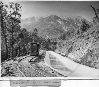
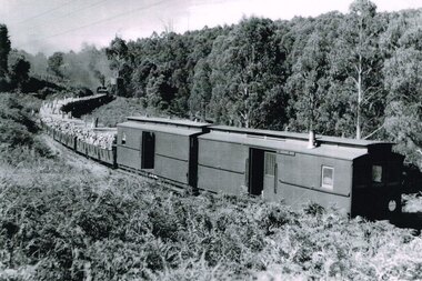
Photo - Bogong Creek Race Line
... Photo - Bogong Creek Race Line...Bogong Creek Race Line... was used to construct the race line and enables the race line to be easily checked for maintenance eg. fallen trees ...Shiny black and white photo showing the railway track, with a locomotive on it, beside the race line. Snow is on the surrounding mountains. ...;Bogong Creek Race Line in pen and attafhed to the photo. ...Bogong Creek Race Line Kiewa Hydro Electric Scheme ;Bogong Creek Race Line in pen and attafhed to the photo. ...The SECV constructed the Kiewa Hydro Electric Scheme which included race lines to catch the water and feed it into the dams that they built to create hydro electric power. The rail line was used to construct the race line and enables the race line to be easily checked for maintenance eg. fallen trees The SECV constructed the Kiewa Hydro Electric Scheme from the late 1940s to 1961 being one of the first hydro schemes and hence environmently friendly.Shiny black and white photo showing the railway track, with a locomotive on it, beside the race line. Snow is on the surrounding mountains. ;Bogong Creek Race Line in pen and attafhed to the photo. On the back "Property of / State Electricity Commission of Victoria/ Publicity photo / Permission to Publish must be obtained / and acknowledgement made. / Negative No. 14-138bogong creek race line, kiewa hydro electric scheme -
 Kiewa Valley Historical Society
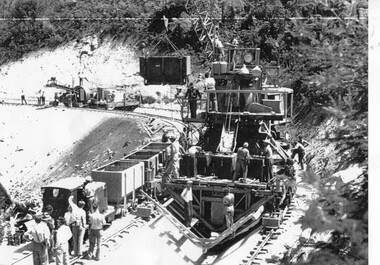
Photograph – Photocopy of black and white photograph of Bogong Creek Race Line. 17/1/51, 17/01/1951
... Photograph – Photocopy of black and white photograph of Bogong Creek Race Line. 17/1/51 ...A start on the construction of Bogong Creek race line was made at the commencement of winter in 1948. ...Photocopy of a black and white SECV photograph No: K 6209 labelled Bogong Creek Race Line ch. 1700. Depicting large group of workers and supervisors working at the site. ...Printed underneath the photograph: STATE ELECTRICITY COMMISSION OF VICTORIA Date: 17/1/51 Time: 10.30am No: K 6209 Kiewa Hydro-Electric Works Bogong Creek Race Line ch. 1700 ...Dated 17/1/52 Photograph – Photocopy of black and white photograph of Bogong Creek Race Line. 17/1/51 ...A start on the construction of Bogong Creek race line was made at the commencement of winter in 1948. Work proceeded in the following years when work on the High Plains was not practicable. In January, 1951 the special trimming machine, the special slip form and concrete mixing and placing equipment was put into service. A shortage of cement caused some delays as well as a sudden financial recession. The race line was completed and put into service in 1952.An historical record showing the machinery used during this time, the number of workers and supervisors involved and the mountainous terrain where they worked. It also demonstrates the OH&S of the period with workers mostly in street clothing with no hard hats or other safety equipment. Several workers can be seen working shirtless or in singlets.Photocopy of a black and white SECV photograph No: K 6209 labelled Bogong Creek Race Line ch. 1700. Depicting large group of workers and supervisors working at the site. Dated 17/1/52Printed underneath the photograph: STATE ELECTRICITY COMMISSION OF VICTORIA Date: 17/1/51 Time: 10.30am No: K 6209 Kiewa Hydro-Electric Works Bogong Creek Race Line ch. 1700 bogong creek raceline; secv; kiewa hydro electric scheme; -
 Kiewa Valley Historical Society
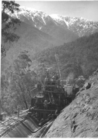
Photograph of Bogong Creek Raceline, Bogong Creek Raceline, circa 1951
... race line...A start on the construction of Bogong Creek race line was made at the commencement of winter in 1948. ...Handwritten on the back of photograph in black ink "Bogong Creek race line"....An historical record showing the machinery used , the number of workers needed at any one time ( about 16 in this photo) and the mountainous terrain of the area. race line cement machinery bogong Handwritten on the back of photograph in black ink "Bogong Creek race line". ...A start on the construction of Bogong Creek race line was made at the commencement of winter in 1948. Work proceeded in the following years when work on the High Plains was not practicable. In January, 1951 the special trimming machine, the special slip form and concrete mixing and placing equipment was put into service. A shortage of cement caused some delays as well as a sudden financial recession. The race line was completed and put into service in 1952. An historical record showing the machinery used , the number of workers needed at any one time ( about 16 in this photo) and the mountainous terrain of the area. Black and white photograph taken during construction of Bogong Creek Raceline, showing the type of machine used for the formation of the concrete lining, the mountainous terrain, a number of workmen and a snow capped Mt. Bogong in the backgroundHandwritten on the back of photograph in black ink "Bogong Creek race line".race line, cement, machinery, bogong -
 Kiewa Valley Historical Society
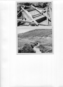
Photos - x6 Raceline repairs on the High Plains
... 6 black and white photos:- 2 with concrete framework, 2 concrete completed and 2 High Plaines race line....Kiewa Hydro Electric Scheme Raceline Water Power Bogong High Plains Alec McCullough Collection 6 black and white photos:- 2 with concrete framework, 2 concrete completed and 2 High Plaines race line. Photos - x6 Raceline repairs on the High Plains ...As part of the Kiewa Hydro Scheme the race lines were created to catch the water and direct it into the Rocky Valley Storage Dam.Part of the Kiewa Hydro Electric Scheme on the Bogong High Plains.6 black and white photos:- 2 with concrete framework, 2 concrete completed and 2 High Plaines race line.Alec McCullough Collectionkiewa hydro electric scheme, raceline, water power, bogong high plains -
 Falls Creek Historical Society
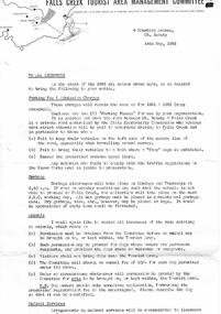
Document - To All Licensees - Parking Fee & Admission Charges; Garbage; Animals
... It clarifies regulations and expectations related to parking fees and admission charges, garbage disposal, animals, water supply, run clearing and race line crossings....It clarifies regulations and expectations related to parking fees and admission charges, garbage disposal, animals, water supply, run clearing and race line crossings. To All Licensees - Parking Fee & Admission Charges; Garbage; Animals Document To All Licensees - Parking Fee & Admission Charges; Garbage; Animals ...Bob (Herman) Hymans (a former member of the Royal Netherlands Navy) was born in Bloemendaal, Holland on 30th September 1922. During World War II he fought against the Japanese in the Dutch East Indies (now Indonesia) and was imprisoned in Changi and on the Burma Railway. After gaining qualifications as a Ski Instructor, Bob arrived in Falls Creek in July 1950. Working as an Instructor and Supervisor at Bogong Lodge, Bob decided his future was in accommodation. He was successful in negotiating an indenture for land from the State Electricity Commission (SEC). It took Bob two years to build his Grand Coeur Chalet but, tragically, it was burned down in August 1961. Bob also built the first Chairlift in Australia. This was a single chairlift and the structure was built from wooden electricity poles. He was constantly full of new ideas and proposals for the village. Bob Hymans died on 7th July 2007. This Collection of documents and letters tells the story of Bob's endeavours to develop Falls Creek into the ski village it is today.This item is significant because it documents actions taken by the Falls Creek Tourist Area Management Committee in their role overseeing the Tourist Area.A circular from the Management Committee prior to the 1963 Ski season. It clarifies regulations and expectations related to parking fees and admission charges, garbage disposal, animals, water supply, run clearing and race line crossings.falls creek tourist area management committee, falls creek administration -
 City of Ballarat Libraries
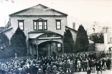
Photograph - Card Box Photographs, Spectators line Grenville Street in front of Alfred Hall 1905
... Spectators, possibly watching a cycling race, line Grenville Street in front of Alfred Hall....City of Ballarat Libraries Eureka Centre Eureka Street Ballarat East goldfields Spectators, possibly watching a cycling race, line Grenville Street in front of Alfred Hall. ...Spectators, possibly watching a cycling race, line Grenville Street in front of Alfred Hall.alfred hall, grenville street, building, persons, public, sport -
 Falls Creek Historical Society
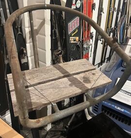
Equipment - Chair from Bob Hymans' Alpine Chairlift
... Available to all visitors, the lower end of the lift was about 90 metres above the Upper Kiewa Road and it ascended 120 vertical metres to the top terminal above the race-line. The forty chairs transported skiers continuously at a speed of 1.5 metres per second, the upward trip taking just over four minutes. ...Available to all visitors, the lower end of the lift was about 90 metres above the Upper Kiewa Road and it ascended 120 vertical metres to the top terminal above the race-line. The forty chairs transported skiers continuously at a speed of 1.5 metres per second, the upward trip taking just over four minutes. ...Bob (Herman) Hymans (a former member of the Royal Netherlands Navy) was born in Bloemendaal, Holland on 30th September 1922. During World War II he fought against the Japanese in the Dutch East Indies (now Indonesia) and was imprisoned in Changi and on the Burma Railway. After gaining qualifications as a Ski Instructor, Bob arrived in Falls Creek in July 1950. Working as an Instructor and Supervisor at Bogong Lodge, Bob decided his future was in accommodation. He was successful in negotiating an indenture for land from the State Electricity Commission (SEC). It took Bob two years to build his Grand Coeur Chalet but, tragically, it was burned down in August 1961. Bob also built the first Chairlift in Australia. This was a single chairlift and the structure was built from wooden electricity poles. He was constantly full of new ideas and proposals for the village. Bob Hymans died on 7th July 2007. This Collection of documents and letters tells the story of Bob's endeavours to develop Falls Creek into the ski village it is today.This chair is significant because it is the last chair from the first chairlift ever constructed in Australia.This is the last known chair of the Alpine Chairlift built in 1957 and deconstructed in 1961. It was built by Bob Hymans from recycled SEC Poles. The chairlift had 40 chairs on the 390 metre trip to the top. It carried its first passengers on 21 July 1957. Available to all visitors, the lower end of the lift was about 90 metres above the Upper Kiewa Road and it ascended 120 vertical metres to the top terminal above the race-line. The forty chairs transported skiers continuously at a speed of 1.5 metres per second, the upward trip taking just over four minutes. Each chair has a safety bar above the rider's knees.bob hymans, australia's first chairlift, alpine chairlift -
 Falls Creek Historical Society
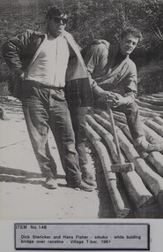
Photograph - Dick Stericker & Hans Fisher building bridge 1961
... Hans worked on the slopes in summer and in winter, including building access bridges over the race-line as shown in this photograph. In 1965 Hans started as the chef Koki Alpine Lodge owned by George Shirling. ...Hans worked on the slopes in summer and in winter, including building access bridges over the race-line as shown in this photograph. In 1965 Hans started as the chef Koki Alpine Lodge owned by George Shirling. ...This item is from the private collection of George Shirling of Red Onion, Falls Creek. It depicts Dick Stericker & Hans Fisher constructing a wooden bridge. They both arrived in Falls Creek in the early 1960s. Hans worked on the slopes in summer and in winter, including building access bridges over the race-line as shown in this photograph. In 1965 Hans started as the chef Koki Alpine Lodge owned by George Shirling. He later worked as cook at various Falls Creek eating houses, as well as working for the lift company and slope maintenance People like Hans made Falls Creek. He passed away at Noosa, Queensland on 18th January 2022. George Shirling arrived in Falls Creek in 1962. He engaged Phil Nowell to build the original Koki Alpine Lodge which opened in 1965 with 14 beds. George operated the lodge with Michael “Baldy” Blackwell as manager. He also graduated in sport psychology in 1981 and was invited to become team psychologist for the Australian Winter Olympic team which went to Albertville, France, in 1992. He later owned the Red Onion Chalet. George credited the success of Koki to “Baldy” Blackwell. “Baldy” and Phil Nowell started the Trackers Mountain Lodge in partnership during the 1980s. In 1971 George sold Koki Lodge to Sigi Doerr. In 2024 the renamed Koki Alpine resort remains a highly popular destination in Falls Creek. George Shirling passed away on 27th February 2023. He had remained actively involved in Falls Creek and was generous with his time and knowledge, always an amazing supporter of The Falls Creek Museum and Falls Creek Village.This item is significant because it features two prominent members of the Falls Creek community.A black and white photograph of Dick Stericker & Hans Fisher taking a break whilst building a bridge. A typed George Shirling Collection number and description is attached. On label: ITEM NO. 148 Dick Stericker & Hans Fisher - smoko - while building bridge over raceline - Village T-bar, 1961george shirling, red onion, hans fisher -
 Sunbury Family History and Heritage Society Inc.
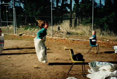
Photograph, Sack race, c1994
... A coloured photograph of a little girl competing in a sack race, reaching the finishing line. A smaller child kneeling on a small chair is looking on, while another competitor is to the left of the images. ...Sports Day Bulla Primary School Sack races A coloured photograph of a little girl competing in a sack race, reaching the finishing line. A smaller child kneeling on a small chair is looking on, while another competitor is to the left of the images. ...The photograph was taken when Bulla Primary School held a sports day at the school for all the students. Parents participated in the day's activities. Events in the program included exercises and sporting activities that were included in the school curriculum.A coloured photograph of a little girl competing in a sack race, reaching the finishing line. A smaller child kneeling on a small chair is looking on, while another competitor is to the left of the images. Discarded sacks from previous races are scattered on the ground behind the finishing line. The photograph was taken with a film camera.sports day, bulla primary school, sack races -
 Phillip Island and District Historical Society Inc.
Photographs, Early 20th Century
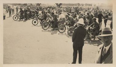
... Six black & white photographs taken on Phillip Island. 365-01: Waiting for start of 100 mile event on Phillip Island for Motor Cycle Race. 365-02: Lined up for start of the 50 mile Grand Prix Race on Phillip Island. 365-03: Start of the 50 mile event. 365-04: Approaching Cowes Pier, Phillip Island. 365-05: The Nobbies, Phillip Island. 365-06: View near The Nobbies with waves breaking over the rocks....Lined up for start of 50 mile. 365-03: Start of 50 mile event. 365-04: Approaching Cowes 365-05: The Nobbies Phillip Island. 365-06: View near The Nobbies Phillip Island. Six black & white photographs taken on Phillip Island. 365-01: Waiting for start of 100 mile event on Phillip Island for Motor Cycle Race. 365-02: Lined up for start of the 50 mile Grand Prix Race on Phillip Island. 365-03: Start of the 50 mile event. 365-04: Approaching Cowes Pier, Phillip Island. 365-05: The Nobbies, Phillip Island. 365-06: View near The Nobbies with waves breaking over the rocks. ...A collection of six photographs donated by John Jansson. The first Grand Prix motorbike and car races were held on a course around the roads of Phillip Island.Six black & white photographs taken on Phillip Island. 365-01: Waiting for start of 100 mile event on Phillip Island for Motor Cycle Race. 365-02: Lined up for start of the 50 mile Grand Prix Race on Phillip Island. 365-03: Start of the 50 mile event. 365-04: Approaching Cowes Pier, Phillip Island. 365-05: The Nobbies, Phillip Island. 365-06: View near The Nobbies with waves breaking over the rocks.365-01: ACUV Races P.I. Waiting for start of 100 mile 365-02: Grand Prix Races. Lined up for start of 50 mile. 365-03: Start of 50 mile event. 365-04: Approaching Cowes 365-05: The Nobbies Phillip Island. 365-06: View near The Nobbies Phillip Island.motorbike racing on phillip island, the nobbies phillip island, cowes pier phillip island, john jansson -
 Bendigo Historical Society Inc.
Photograph - BERT GRAHAM COLLECTION: ANNUAL CLUB PICNIC, 1961
... A Mother's race with 4 mothers, lined up and ready to go, one man at rear standing with hands on hips, another getting ready , and another sitting near the start line. ...A Mother's race with 4 mothers, lined up and ready to go, one man at rear standing with hands on hips, another getting ready , and another sitting near the start line. ...Photograph black & white, Bert Graham Collection, Annual Club Picnic 1961, Lake Jubilee, Daylesford. A Mother's race with 4 mothers, lined up and ready to go, one man at rear standing with hands on hips, another getting ready , and another sitting near the start line. In the background are 2 buses and a FX Holden sedan possiblty black.Trees surounding the water's edge.bendigo, clubs, bendigo east swimming club -
 Ballarat Tramway Museum
Photograph - Black & White Photograph/s, Geoff Grant, 19/06/1955 12:00:00 AM
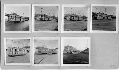
... Numbered from left to right, top to bottom are: 477.1 - Decorated tram at Batman Ave 7/5/1955 477.2 -M&MTB W2 434 at Camberwell depot entry 7/5/1955 477.3 - M&MTB SW2 426 at Camberwell depot entry 7/5/1955 477.4 - M&MTB 727 at Camberwell depot entry 7/5/1955 477.5 - M&MTB Q190 on Camberwell depot fan 7/5/1955 477.6 - M&MTB Y613 on Camberwell depot fan 7/5/1955 477.7 - Caulfield Race day, line up of trams looking towards Crystal Palace Theatre from the railway underpass, 3/9/1955. ...Numbered from left to right, top to bottom are: 477.1 - Decorated tram at Batman Ave 7/5/1955 477.2 -M&MTB W2 434 at Camberwell depot entry 7/5/1955 477.3 - M&MTB SW2 426 at Camberwell depot entry 7/5/1955 477.4 - M&MTB 727 at Camberwell depot entry 7/5/1955 477.5 - M&MTB Q190 on Camberwell depot fan 7/5/1955 477.6 - M&MTB Y613 on Camberwell depot fan 7/5/1955 477.7 - Caulfield Race day, line up of trams looking towards Crystal Palace Theatre from the railway underpass, 3/9/1955. ...A set of seven 2 1/4" square photographs mounted onto a sheet of manila cardboard - contact prints of each negative. Numbered from left to right, top to bottom are: 477.1 - Decorated tram at Batman Ave 7/5/1955 477.2 -M&MTB W2 434 at Camberwell depot entry 7/5/1955 477.3 - M&MTB SW2 426 at Camberwell depot entry 7/5/1955 477.4 - M&MTB 727 at Camberwell depot entry 7/5/1955 477.5 - M&MTB Q190 on Camberwell depot fan 7/5/1955 477.6 - M&MTB Y613 on Camberwell depot fan 7/5/1955 477.7 - Caulfield Race day, line up of trams looking towards Crystal Palace Theatre from the railway underpass, 3/9/1955. Image btm477i is of the card itself and individual images higher res scans made 12/12/2020. trams, tramways, melbourne, camberwell depot, prahran centenary, caulfield races , tram 434, 426, 727, 190, 613 -
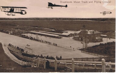 Bendigo Historical Society Inc.
Postcard - BASIL WATSON COLLECTION: BROOKLANDS MOTOR TRACK AND FLYING GROUND
... To the back are work sheds, further to the left are spectators cars and in the distance is open space with trees. Spectators line the race track both sides watching a racing car. ...To the back are work sheds, further to the left are spectators cars and in the distance is open space with trees. Spectators line the race track both sides watching a racing car. ...The postcard shows three planes flying above the Brooklands motor track with 'Brooklands Motor Track and Flying Ground'. To the right is a large two story brick building and on the left of the building is a long open covered vehicle stall. To the back are work sheds, further to the left are spectators cars and in the distance is open space with trees. Spectators line the race track both sides watching a racing car. In the foreground is a hill with fencing down to the track and spectators along the fence.Valentine Seriesaviation, civilian, brooklands motor track -
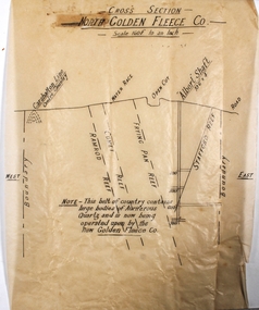 Bendigo Historical Society Inc.
Plan - North Golden Fleece Mine
... Annotations on plan: Carshalton line, water race, open cut, Albert Shaft 10'6" x 4, road. ...Annotations on plan: Carshalton line, water race, open cut, Albert Shaft 10'6" x 4, road. ...North Golden Fleece Gold Mine was located approx. 1200m west of Spring Gully Reservoir, near Diamond Hill Road. Plan drawn on tan tissue paper, black text. Written across top of plan: 'Cross Section, North Golden Fleece Co. 160' to an inch'. Annotations on plan: Carshalton line, water race, open cut, Albert Shaft 10'6" x 4, road. East and West marked on plan. On bottom of plan: ' This belt of country contains large bodies of auriferous quartz and is now being operated upon by the New Golden Fleece Co.' Plan forms part of the Margaret Roberts Collection of mining records. margaret roberts, gold, gold mine, bendigo, north golden fleece gold mine, spring gully reservoir -
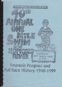 Warrnambool and District Historical Society Inc.
Work on paper - Report, Warrnambool Surf Lifesaving Club, 40th Annual One Mile Swim of the Hopkins River, 1999
... Since 1961 a measured One Mile Course (1600 metres) was used, the course being up river for approx. 286 metres, then to the bridge and back to the jetty to the finishing line. It was a handicap race. The race was abandoned after 46 years (2005). ...Since 1961 a measured One Mile Course (1600 metres) was used, the course being up river for approx. 286 metres, then to the bridge and back to the jetty to the finishing line. It was a handicap race. The race was abandoned after 46 years (2005). ...The Hopkins River One Mile Swim started in 1960 as part of an Aquatic Day to raise funds for the Warrnambool Olympic Pool. Since 1961 a measured One Mile Course (1600 metres) was used, the course being up river for approx. 286 metres, then to the bridge and back to the jetty to the finishing line. It was a handicap race. The race was abandoned after 46 years (2005). The booklet is of some importance as it gives the details of the Hopkins River One Mile Race, an event that was a prominent one in Warrnambool for 46 years. The booklet records the achievements of the competitors and the work of the committees involved and will be useful for researchers. This is a booklet containing a souvenir program for the 40th Annual One Mile Swim in the Hopkins River in 1999 and a Full Race History from 1960 to 1999. It has been produced in-house by the Warrnambool Surf Lifesaving Club and has a blue cardboard front cover and a grey back cover. The photocopied and typed pages have been bound with black plastic. The contents include newspaper cuttings, photocopies of photographs, lists of winners and a list of the race’s sponsors. There are three loose sheets.Front Cover: Warrnambool Surf Lifesaving Club, 40th Annual One Mile Swim in the Hopkins River, Sunday 14th March 1999, 2 p.m., Souvenir Program and Full Race History 1960-1999warrnambool surf lifesaving club, hopkins river mile swim, hopkins river -
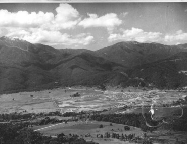 Kiewa Valley Historical Society
Photograph of Mt. Beauty, Mt. Beauty from transmission line, Approx 1950/51
... Beauty surrounded by farmland and before the regulating pondage was built to discharge water from the power stations via the West Kiewa tail race tunnel into the Kiewa River. mt. beauty construction pondage state electricity commission Hand written on back of photograph "Mt. Beauty from Transmission Line ...This photo is of the very newly constructed State Electricity Commission town of Mt. Beauty. The houses up to Nelse street were erected from 1946 onward and then the township was extended beyond Nelse Street in 1950 which places this photograph about 1950/51. There is no evidence of work being commenced on the regulating pondage but the tail race canal can be seen on the centre right of photo. The workmen's camp was enlarged in 1950 to the extent of providing accommodation for a total of 1,200. There are a number of dwellings on Simmonds Creek and the road to Falls Creek can clearly be seen. Snow capped Mt. Bogong is in the upper left of the photo with Mt. Beauty behind the township rising to Big Hill beyond that.Shows the newly constructed town of Mt. Beauty surrounded by farmland and before the regulating pondage was built to discharge water from the power stations via the West Kiewa tail race tunnel into the Kiewa River. Black and white photographHand written on back of photograph "Mt. Beauty from Transmission Line"mt. beauty, construction, pondage, state electricity commission -
 Federation University Historical Collection
Trophy, Six Meter Henk Miller Line Special: 1975 - 1986, 1975
... Race held each year on the Hazelwood Pondage, Gippsland. It was an activity held by the students of the Gippsland Institute of Advanced Education, 1975 through to 1986. Known as the 'Six Metre Henk Miller Line...Race held each year on the Hazelwood Pondage, Gippsland. It was an activity held by the students of the Gippsland Institute of Advanced Education, 1975 through to 1986. Known as the 'Six Metre Henk Miller Line ...This perpetual cup was awarded to the winners of the Raft Race held each year on the Hazelwood Pondage, Gippsland. It was an activity held by the students of the Gippsland Institute of Advanced Education, 1975 through to 1986. Known as the 'Six Metre Henk Miller Line Special' The cup was passed to the Federation University Historical Collection at Mt Helen Campus.Silver plated cup on bakelite base. Fine handle each side. Silver plate on base.Base: G I A E - Annual Raft Race - Perpetual Trophy - Hazelwood Pondage Cup: Names of those who participated each yearraft race, perpetual cup, hazelwood pondage, gippsland institute of advanced education, six meter, henk miller -
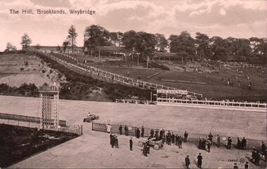 Bendigo Historical Society Inc.
Postcard - BASIL WATSON COLLECTION: RACETRACK BROOKLANDS, WEYBRIDGE
... race track Valentines's Series black and white postcard. On top 'The Hill, Brooklands, Weybridge' Image shows racetrack, two cars - one on track, one outside fence line. ...black and white postcard. On top 'The Hill, Brooklands, Weybridge' Image shows racetrack, two cars - one on track, one outside fence line. Men standing on edge of track in foreground.Valentines's Seriesevent, sports, vehicle race track -
 The Beechworth Burke Museum
Photograph
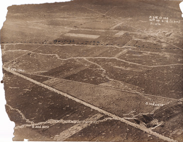
... line marking on this record denotes a section of the Western Front. The Western Front was the main theatre of war during World War I. Following the outbreak of war in August 1914, the German Army opened the Western Front by invading Luxembourg and Belgium, then gaining military control of important industrial regions in France. The German advance was halted with the Battle of the Marne. Following the Race...line marking on this record denotes a section of the Western Front. The Western Front was the main theatre of war during World War I. Following the outbreak of war in August 1914, the German Army opened the Western Front by invading Luxembourg and Belgium, then gaining military control of important industrial regions in France. The German advance was halted with the Battle of the Marne. Following the Race ...Taken some time between 1914-18, the photograph depicts an aerial view of trenches in France. The image mostly shows rural landscape, although there is a house in the bottom right corner. A dotted line has been drawn across the photograph, marking the section of trenches that belonged to British forces during World War I. It is believed that the line marking on this record denotes a section of the Western Front. The Western Front was the main theatre of war during World War I. Following the outbreak of war in August 1914, the German Army opened the Western Front by invading Luxembourg and Belgium, then gaining military control of important industrial regions in France. The German advance was halted with the Battle of the Marne. Following the Race to the Sea, both the French-British and German armies dug in along a meandering line of fortified trenches, stretching from the North Sea to the Swiss frontier with France. Between 1915 and 1917 there were several offensives along the Western Front. The attacks employed massive artillery bombardments and massed infantry advances. Entrenchments, machine gun emplacements, barbed wire and artillery repeatedly inflicted severe casualties during attacks and counter-attacks and no significant advances were made. Among the most notable of these offensives were the Battle of Verdun (1916), the Battle of the Somme (1916), and the Battle of Passchendaele (1917).The record is historically significant due to its connection to World War I. This conflict is integral to Australian culture as it was the single greatest loss of life and the greatest repatriation of casualties in the country's history. Australia’s involvement in the First World War began when the Australian government established the Australian Imperial Force (AIF) in August 1914. Immediately, men were recruited to serve the British Empire in the Middle East and on the Western Front. The record has strong research potential. This is due to the ongoing public and scholarly interest in war, history, and especially the ANZAC legend, which is commemorated annually on 25 April, known as ANZAC Day.Sepia rectangular photograph printed on matte photographic paper.Obverse: A.3FE.O.146 / G2R 29 . 6 . 18 (Y p.m) / F= 10 1/4 / British Line / ------------------------------------------ / P. 250 1040 / 0. 30d. 0010 / 0. 30d. 3070 /military album, military, war, wwi, world war i, france, great britain, trenches, village, rural, western front -
 The Beechworth Burke Museum
Photograph
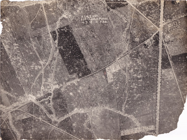
... Following the Race to the Sea, both the French-British and German armies dug in along a meandering line of fortified trenches, stretching from the North Sea to the Swiss frontier with France. ...Following the Race to the Sea, both the French-British and German armies dug in along a meandering line of fortified trenches, stretching from the North Sea to the Swiss frontier with France. ...Taken some time between 1914-18, the photograph depicts an aerial view of trenches in France. The image mostly shows rural landscape, although there is a cluster of houses in the top right corner. It is believed that this record denotes a section of the Western Front. The Western Front was the main theatre of war during World War I. Following the outbreak of war in August 1914, the German Army opened the Western Front by invading Luxembourg and Belgium, then gaining military control of important industrial regions in France. The German advance was halted with the Battle of the Marne. Following the Race to the Sea, both the French-British and German armies dug in along a meandering line of fortified trenches, stretching from the North Sea to the Swiss frontier with France. Between 1915 and 1917 there were several offensives along the Western Front. The attacks employed massive artillery bombardments and massed infantry advances. Entrenchments, machine gun emplacements, barbed wire and artillery repeatedly inflicted severe casualties during attacks and counter-attacks and no significant advances were made. Among the most notable of these offensives were the Battle of Verdun (1916), the Battle of the Somme (1916), and the Battle of Passchendaele (1917).The record is historically significant due to its connection to World War I. This conflict is integral to Australian culture as it was the single greatest loss of life and the greatest repatriation of casualties in the country's history. Australia’s involvement in the First World War began when the Australian government established the Australian Imperial Force (AIF) in August 1914. Immediately, men were recruited to serve the British Empire in the Middle East and on the Western Front. The record has strong research potential. This is due to the ongoing public and scholarly interest in war, history, and especially the ANZAC legend, which is commemorated annually on 25 April, known as ANZAC Day.Black and white rectangular photograph printed on matte photographic paper.Obverse: A.3.FE.2.291 / 62D O.20bd.P.25O.C / 16.7.18 / 12 / F 8 1/4 / Reverse: 6532military album, military, army, war, wwi, world war i, france, trenches -
 The Beechworth Burke Museum
Photograph
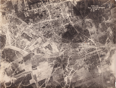
... Following the Race to the Sea, both the French-British and German armies dug in along a meandering line of fortified trenches, stretching from the North Sea to the Swiss frontier with France. ...Following the Race to the Sea, both the French-British and German armies dug in along a meandering line of fortified trenches, stretching from the North Sea to the Swiss frontier with France. ...Taken some time between 1914-18, the photograph depicts an aerial view of Villers-Bretonneux in France, a region which was part of the Western Front during World War I. The image mostly shows rural landscape. The Western Front was the main theatre of war during World War I. Following the outbreak of war in August 1914, the German Army opened the Western Front by invading Luxembourg and Belgium, then gaining military control of important industrial regions in France. The German advance was halted with the Battle of the Marne. Following the Race to the Sea, both the French-British and German armies dug in along a meandering line of fortified trenches, stretching from the North Sea to the Swiss frontier with France. The First Battle of Villers-Bretonneux occurred between 30 March - 5 April 1918. It took place during Operation Michael, part of the German Spring Offensive on the Western Front. The offensive began against the British Fifth Army and the Third Army on the Somme, and pushed back the British and French reinforcements on the north side of the Somme. The capture of Villers-Bretonneux, close to Amiens, a strategically important road and rail-junction, would have brought the Germans within artillery-range. In late March, troops from the Australian Imperial Force were brought south from Belgium as reinforcements to help shore up the line. In early April, the Germans launched an attack to capture Villers-Bretonneux. After a determined defence by British and Australian troops, the attackers were close to success until a counter-attack by the 9th Australian Infantry Brigade and British troops late in the afternoon of 4 April restored the situation and halted the German advance on Amiens. The Second Battle of Villers-Bretonneux occurred between 24 - 27 April 1918, during the German Spring Offensive to the east of Amiens. It is notable for being the first occasion on which tanks fought against each other. A counter-attack by two Australian brigades and a British brigade during the night of 24 April partly surrounded Villers-Bretonneux, and on 25 April, the town was recaptured. On 26 April, the role of the Moroccan division of the French army was crucial in pushing back German units. Australian, British and French troops nearly restored the original front line by 27 April.The record is historically significant due to its connection to World War I. This conflict is integral to Australian culture as it was the single greatest loss of life and the greatest repatriation of casualties in the country's history. Australia’s involvement in the First World War began when the Australian government established the Australian Imperial Force (AIF) in August 1914. Immediately, men were recruited to serve the British Empire in the Middle East and on the Western Front. Additionally, the record's significance is enhanced by its depiction of Villers-Bretonneux. The battles that occurred in this town during World War I are especially historically significant to Australia as this is where the Australian Imperial Force had one their greatest World War I victories. An Australian flag still flies over Villers-Bretonneux in the present. Furthermore, a plaque outside the Villers-Bretonneux Town Hall recounts the battles fought to save the town in 1918. Kangaroos feature over the entrance to the Town Hall, and the main street is named Rue de Melbourne. More officially, recognition of the significance of the battle in Villers-Bretonneux is found at the Australian National Memorial, which was built just outside the town. It commemorates all Australians who fought in France and Belgium and includes the names of 10,772 who died in France and have no known grave. Each year, a small ceremony is held at the memorial to mark the sacrifice made by the soldiers. Lastly, the record has strong research potential. This is due to the ongoing public and scholarly interest in war, history, and especially the ANZAC legend, which is commemorated annually on 25 April, known as ANZAC Day.Sepia rectangular photograph printed on matte photographic paper.Obverse: yAE.2.35. / 125 / 62d.2834.35.36.VA.5. / 12.G.18-11 / F.-(?)" /military album, wwi, world war i, villers-bretonneux, australian imperial force, aif, france, war, army, conflict, germany, 1918, battle -
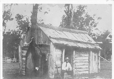 Halls Gap & Grampians Historical Society
Photograph - B/W, c 1850s
... line. Man is wearing a hat and tie. A gun is leaning up against wall of hut. A sheep or cattle race can be seen in left corner of photo. ...line. Man is wearing a hat and tie. A gun is leaning up against wall of hut. A sheep or cattle race can be seen in left corner of photo. ...This windowless bark hut would have been used by stockmen who looked after sheep and cattle in the Fyans Valley. This hut was situated at the site later named the Borough Huts. See p8 Bridging the Gap Photo shows a man sitting outside a wooden slab hut. The hut has a tin flashing along top roof line. Man is wearing a hat and tie. A gun is leaning up against wall of hut. A sheep or cattle race can be seen in left corner of photo. buildings, houses -
 Eltham District Historical Society Inc
Slide, Main Road, Lower Plenty, 25 Jul 1973
... Contestants would line up and race each other down the hill to the finish line at Bolton Street. ...Contestants would line up and race each other down the hill to the finish line at Bolton Street. ...This section of Main Road was known by locals as the "Windy Mile" due to its many little wists and turns. It was also the setting for Billy Cart derbies held on special occassions such as the Eltham Easter Gymkhana at Eltham Lower Park. Contestants would line up and race each other down the hill to the finish line at Bolton Street. Main Road, Lower Plenty underwent substantial changes when it was duplicated with the road becoming two lanes each way and split level due to the cross gradient. This particular section running down the hill from Panorama Avenue to Bolton Street with its twists and turns had many of them straightened out during the road widening constuction work.35 mm colour positive transparency Mount - Agfacolor Service (Blue)main road, infrastructure, lower plenty, roads, windy mile -
 Victorian Interpretive Projects Inc.
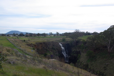
Photograph - Photograph - Colour, Clare Gervasoni, Lal Lal Falls, Victoria, 2014, 09/2014
... On the reserve opposite, a Race Meeting was held on every New Years Day from 1860 until 1938, attracting crowds of up to 20,000 people. A branch Railway Line...On the reserve opposite, a Race Meeting was held on every New Years Day from 1860 until 1938, attracting crowds of up to 20,000 people. A branch Railway Line ...Lal Lal Falls Reserve contains one of the most spectacular waterfalls in the Moorabool Shite. The watefall is part of the on Lal Lal Creek, a tributary of the Moorabool River. and plunges 30 metres from a high basalt column into a deep ravine. Culturally, the Falls are believed to be the earthly home of Bunjil, the All Father or Creator to most Victorian Aboriginal tribes. The name Lal Lal is thought to be Aboriginal for "dashing of waters". The Lal Lal Falls is listed on the Site Registry of Aboriginal Affairs Victoria as a spiritual place. in 1837 a Government Survey Party led by Frederick D'Arcy documented these Falls on the west branch of the Moorabool River. On the reserve opposite, a Race Meeting was held on every New Years Day from 1860 until 1938, attracting crowds of up to 20,000 people. A branch Railway Line was constructed from the Lal Lal station to the Racecourse to convey the crowds.Colour photographs of Lal Lal Falls near Ballarat, Victoria.lal lal falls, waterfall, lal lal, bunjil -
 Monbulk RSL Sub Branch
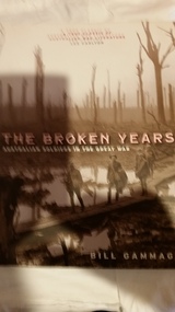
Book, Melbourne University Publishing, The broken years, 2010
... race and country. But the horror and tragedy of the conflict brought fundamental changes in outlook. Many of the pre-war enthusiasms persisted, but the days of unquestioning allegiance to Empire were beginning to come to an end, to be replaced by the bittersweet tradition of Anzac. Dr Gammage shows how and why these changes took place. Using the diaries and letters of one thousand front-line ...Before the First World War most Australians shared the emotions and traditions of the British Empire. Proud of their British heritage, anxious to raise the Imperial status of Australia, they were eager to fight and, if need be, to die in defence of their race and country. But the horror and tragedy of the conflict brought fundamental changes in outlook. Many of the pre-war enthusiasms persisted, but the days of unquestioning allegiance to Empire were beginning to come to an end, to be replaced by the bittersweet tradition of Anzac. Dr Gammage shows how and why these changes took place. Using the diaries and letters of one thousand front-line soldiers of the First Australian Imperial Force, most of them now part of a unique collection housed in the Australian War Memorial in Canberra, he reconstructs the motives and expectations with which these men volunteered and the experiences they encountered. He highlights and examines the new attitudes to war and to the homeland that developed and foreshadows the important effects in Australia of the changed outlook brought home by the survivors. Those who have returned from war will recognise immediately the raw realities faced by the 'diggers', the growing disillusionment, and the hopes for the future. Those with fathers, husbands, or brothers who served, and all those concerned with what happens to men at war, cannot fail to be moved by the simple dignity of the men{u2019}s accounts, or by the understated courage with which they wrote to their families of the miseries they endured. This book, written with sensitivity and scholarly care, must be read if we are to understand war and its impact on the ethos of a nation.Index, bib, ill, notes, p.288.non-fictionBefore the First World War most Australians shared the emotions and traditions of the British Empire. Proud of their British heritage, anxious to raise the Imperial status of Australia, they were eager to fight and, if need be, to die in defence of their race and country. But the horror and tragedy of the conflict brought fundamental changes in outlook. Many of the pre-war enthusiasms persisted, but the days of unquestioning allegiance to Empire were beginning to come to an end, to be replaced by the bittersweet tradition of Anzac. Dr Gammage shows how and why these changes took place. Using the diaries and letters of one thousand front-line soldiers of the First Australian Imperial Force, most of them now part of a unique collection housed in the Australian War Memorial in Canberra, he reconstructs the motives and expectations with which these men volunteered and the experiences they encountered. He highlights and examines the new attitudes to war and to the homeland that developed and foreshadows the important effects in Australia of the changed outlook brought home by the survivors. Those who have returned from war will recognise immediately the raw realities faced by the 'diggers', the growing disillusionment, and the hopes for the future. Those with fathers, husbands, or brothers who served, and all those concerned with what happens to men at war, cannot fail to be moved by the simple dignity of the men{u2019}s accounts, or by the understated courage with which they wrote to their families of the miseries they endured. This book, written with sensitivity and scholarly care, must be read if we are to understand war and its impact on the ethos of a nation. world war 1914-1918 - personal correspondence, world war 1914-1918 - social conditions -
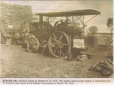 Bendigo Historical Society Inc.
Newspaper - JENNY FOLEY COLLECTION: STACKS ON
... The station and railway yards opened in 1891 ad were last used in 1969 after bushfires had destroyed bridges on the line. The advertised St Patrick's Day race meeting was held on Saturday 18th March and a special train for patrons was run form Castlemaine, leaving at 1.15pm and returning at 7pm....The station and railway yards opened in 1891 ad were last used in 1969 after bushfires had destroyed bridges on the line. The advertised St Patrick's Day race meeting was held on Saturday 18th March and a special train for patrons was run form Castlemaine, leaving at 1.15pm and returning at 7pm. ...The Maldon-Laanacoorie railway line was never completed so Shelbourne became to termination point of this line. The station and railway yards opened in 1891 ad were last used in 1969 after bushfires had destroyed bridges on the line. The advertised St Patrick's Day race meeting was held on Saturday 18th March and a special train for patrons was run form Castlemaine, leaving at 1.15pm and returning at 7pm.Bendigo Advertiser '' the way we were'' from 2002. Stacks on: stacking wheat at Shelborne in 1916. The poster stuck to the engine is advertising the St Patrick's Day races at the Maldon racecourse on March 18, 1916. The clip is in a folder.newspaper, bendigo advertiser, the way we were -
 Otway Districts Historical Society
Photograph, R. Preston, Taking water at Wimba tank, 8 January 1958
... line in in March, 1902, as an unnamed stopping place. It was renamed "Wimba" on 17 November, 1902. A water tank for locomotive requirements was placed on the side of a hill about 100 metres south of the station. Wimba was not provided with a loop siding but had a passenger shelter until 1936 when the roads took over. A sheep race...line in in March, 1902, as an unnamed stopping place. It was renamed "Wimba" on 17 November, 1902. A water tank for locomotive requirements was placed on the side of a hill about 100 metres south of the station. Wimba was not provided with a loop siding but had a passenger shelter until 1936 when the roads took over. A sheep race ...Wimba station is 37.3 km south of Colac. This station, originally called "Bunding", opened with the line in in March, 1902, as an unnamed stopping place. It was renamed "Wimba" on 17 November, 1902. A water tank for locomotive requirements was placed on the side of a hill about 100 metres south of the station. Wimba was not provided with a loop siding but had a passenger shelter until 1936 when the roads took over. A sheep race was provided near the passenger shelter. The station closed with the line.B/W. An UP goods train loaded with pulp wood on NQR wagons and two NC guard's vans taking water at Wimba tank on 8 January 1958. wimba; railways; -
 Bendigo Historical Society Inc.
Document - ARTICLES FOR ROYAL HISTORICAL SOCIETY (BENDIGO BRANCH) NEWSLETTER MAY 1973
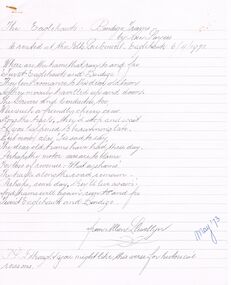
... line poem recited at the Folklore Concert, Eaglehawk 6/4/1973; 2.'' Bells in and around Bendigo - No 5 the original bells - St Pauls Church, Bendigo'' -history of bells from 1871 to 1962; 3. ''The Sydenham Gardens Hotel'' in Sydenham Gardens Rd. (Finn Street) - mention of picnics, gardens, race...line poem recited at the Folklore Concert, Eaglehawk 6/4/1973; 2.'' Bells in and around Bendigo - No 5 the original bells - St Pauls Church, Bendigo'' -history of bells from 1871 to 1962; 3. ''The Sydenham Gardens Hotel'' in Sydenham Gardens Rd. (Finn Street) - mention of picnics, gardens, race ...Articles for Royal Historical Society (Bendigo Branch) Newsletter May 1973. 1. The Eaglehawk - Bendigo Trams- a 16 line poem recited at the Folklore Concert, Eaglehawk 6/4/1973; 2.'' Bells in and around Bendigo - No 5 the original bells - St Pauls Church, Bendigo'' -history of bells from 1871 to 1962; 3. ''The Sydenham Gardens Hotel'' in Sydenham Gardens Rd. (Finn Street) - mention of picnics, gardens, race-track; 4. ''Royal Relics'' re two Royal Arms in Bendigo - a. in the photographic studio opposite the Shamrock Hotel and b. in the MacCullagh Chapel, St Paul’s church - mention of Bartlett Bros; A E Burrows & Co, Holdsworth's Chemist shop (Pall Mall).business, retail, bendigo, st pauls church. -
 Bendigo Historical Society Inc.
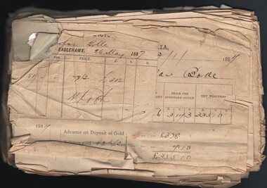
Document - GOLD SALE NOTES FOR NICHOLAS BOLLE, 1868 - 1887
... race by a pipe, now largely buried. The dumps are weathered and partially quarried, but the puddling machine is in good con 40 metre-long mullock heap with one dumping line running north from a filled shaft. ...race by a pipe, now largely buried. The dumps are weathered and partially quarried, but the puddling machine is in good con 40 metre-long mullock heap with one dumping line running north from a filled shaft. ...Nicholas John Bolle was born in Dorstadt, Germany in 1836 to parents Heinrich (Johannes Heinrich Wilhelm) and Friederike Hartmann (Anne Marie Friedericke). Around the age of 20 he immigrated to Australia and made his way, most likely on foot, 150km in a northerly direction to the Bendigo goldfields. In March 1863 Nicholas registered his first mining claim, naming it Bolle’s Reef. Having worked this reef until it no longer paid, he went on a prospecting tour of the area and found another gold reef towards Elysian Flat, staked a claim and registered it under the name of his beloved wife ‘Rosanna’. Sadly, as was often the case, the cost of hiring men to get the gold out of the ground, and removing it from the clay and quartz, outweighed the amount of profit he was making from his discoveries. In November 1863 while living and working at Old Tom Gully, Nicholas appeared in the Government Gazette as insolvent. Nicholas continued to struggle on, scoping out the surrounding area in the Whipstick Forest, and having some little success and by 1869 he was given a government reward of 25 pounds for discovering a new area of gold in the Whipstick. The Government Gazette records this reward – 'for the discovery of the Whipstick, 25 pounds' (Government Gazette 1869) By 1872 Nicholas had established a quartz crushing plant at his mine in Old Tom Gully, (the Old Tom mine) a remote place in the middle of the Whipstick. Mining was a dangerous business, and in 1875 Nicholas was called as a witness in a coroner’s inquest into the death of a John Bashton who was accidentally killed in a mining accident at nearby Easter Claim in December. In 1881, he was again called to give evidence when one of his employees Mr Thomas Garrett was killed while working at his claim at Old Tom Reef. So we are fortunate to have Nicholas describing his day’s work in his own words. Reference: Michelle Dennis Family History http://www.michelledennis.com.au/?page_id=1067) The Old Tom Mine site is situated between Old Tom Road, Scotsman Road, Eaglehawk-Neilborough Road and an unnamed road, Whipstick VIC 3556. The Marong Heritage Study, Mining Sites ( City of Greater Bendigo) describes the former mine site as follows: '40 metre-long mullock heap with one dumping line running north from a filled shaft. The heap has been partially quarried. 20 metres south is a scatter of red hand-made bricks and rough concrete rubble. Further south there are smaller mullock dumps and a line of shallow reef workings Surface workings 30 metres west of the mullock dump, running north, is a line of small mullock paddocks, terminating in a shallow open cut. On the same line to the south, in an area north and west of the most southerly section of reef workings there is an area of hydraulic sluicing. West of the cyanide works and along Scotchman Gully there are patches of shallow alluvial workings. Battery site On the eastern side of the open-cut is a small mullock paddock, below which is a spread of hand-made red bricks and fire bricks. Near this rubble is a dry dam, with traces of battery sand nearby. Puddling machine site 10 metres north of the water race is the outline of a 20 foot diameter puddling machine. The central mound retains its wooden post and fragments of timber side-boarding are still present in the puddling trench. Water was fed to the puddling machine from the race by a pipe, now largely buried. The dumps are weathered and partially quarried, but the puddling machine is in good con 40 metre-long mullock heap with one dumping line running north from a filled shaft. The heap has been partially quarried. 20 metres south is a scatter of red hand-made bricks and rough concrete rubble. Further south there are smaller mullock dumps and a line of shallow reef workings Surface workings 30 metres west of the mullock dump, running north, is a line of small mullock paddocks, terminating in a shallow open cut. On the same line to the south, in an area north and west of the most southerly section of reef workings there is an area of hydraulic sluicing. West of the cyanide works and along Scotchman Gully there are patches of shallow alluvial workings'. Reference: https://www.goldfieldsguide.com.au/explore-location/553/old-tom-mine/ Document. Gold Sale notes for Nicholas Bolle. Papers pinned together covering the years 1868 - 1887 being statement of gold melted and assayed for Nicholas Bolle from the Eaglehawk branch of the Bank of Victoria. A few of the papers are from the Bank of New South Wales - Eaglehawk Branch, Bank of Australasia, Bank of Australasia Gold Office. The earliest statement dated 3 Jul 1868 is for Messrs Harrison & Bashton. Other early ones are for Derbyshire Reef. The Bank of Victoria cards mention R. H. Andrews, Agent on the back. The Bank of Australasia Gold Office statement contains an ink picture of the building on the back.gold sale notes for nicholas bolle, bank of victoria - eaglehawk branch, bank of new south wales, bank of australasia, bank of australasia gold office, messrs harrison & bashton, derbyshire reef, r. h. andrews -
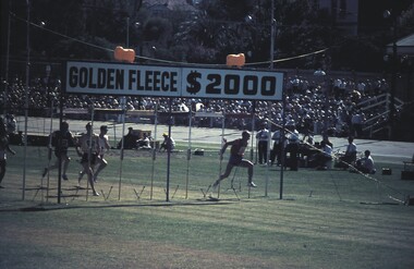 Bendigo Historical Society Inc.
Slide - VAL DENSWORTH COLLECTION: BENDIGO 2000, 1967
... Runners crossing the line in the heat of the race....Runners crossing the line in the heat of the race. Slide VAL DENSWORTH COLLECTION: BENDIGO 2000. ...Slide. Bendigo 2000. Runners crossing the line in the heat of the race.slide, bendigo, bendigo 2000., bendigo 2000.