
Showing 31 items matching "railway culvert"
-
 Eltham District Historical Society Inc
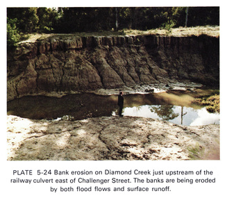
Work on paper (Sub-Item) - Photograph, Bank erosion on Diamond Creek just upstream of the railway culvert east of Challenger Street
... Bank erosion on Diamond Creek just upstream of the railway culvert east of Challenger Street...Colour photograph of bank erosion on Diamond Creek just upstream of the railway culvert east of Challenger Street in Diamond Creek township. ...Colour photograph of bank erosion on Diamond Creek just upstream of the railway culvert east of Challenger Street in Diamond Creek township. ...Colour photograph of bank erosion on Diamond Creek just upstream of the railway culvert east of Challenger Street in Diamond Creek township. The banks are eroded by both flood flows and surface runoffeltham, drain, diamond creek, erosion, challenger street -
 Federation University Historical Collection
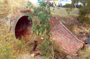
Photograph - Photograph Colour, Clare Gervasoni, Former Ballarat - Buninyong Railway Line Barrel Culvert, 1995, 2005
... Former Ballarat - Buninyong Railway Line Barrel Culvert, 1995...railway...brick...train...culvert...Sixteen colour photographs of a brick culvert built as part of the Ballarat - Buninyong Railway Line taken in 1995. ....1 shows part of a the track still on location railway brick train culvert barrel culvert Sixteen colour photographs of a brick culvert built as part of the Ballarat - Buninyong Railway Line taken in 1995. ....1 shows part of a the track still on locationSixteen colour photographs of a brick culvert built as part of the Ballarat - Buninyong Railway Line taken in 1995. The culvert is in disrepair and is located at Mt Helen. The culvert has bricks throughout it and creates a circular tunnel.railway, brick, train, culvert, barrel culvert -
 Federation University Historical Collection
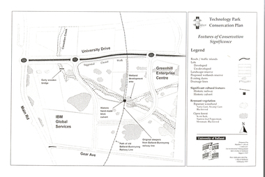
Document - Plan, Mathew Gibson, Centre for Environmental Management, Ballarat Technology Park Conservation Plan, 1997, 1997
... ...brick railway culvert...The plan includes the Canadian Creek, an historic hand-made brick culvert, Canadian Wetland Development, early wooden bridge, old path of the Ballarat-Buninyong Railway line, Greenhill Enterprise Centre and IBM Global Services....The Ballarat Technology Park is on the Mount Helen Campus. ballarat technology park greenhill enterprise centre ibm global enterprises ballarat-buninyong railway line canadian wetlands brick railway culvert canadian creek riparian woodland yarra gum swamp gum blackwood remnant vegetation scent bark narrow-leaf peppermint messmate centre for environmental management Mount Helen Campus A4 photocopy of a plan of the Ballarat Technology Park showing features of conservation significance. ...The Ballarat Technology Park is on the Mount Helen Campus.A4 photocopy of a plan of the Ballarat Technology Park showing features of conservation significance. The plan includes the Canadian Creek, an historic hand-made brick culvert, Canadian Wetland Development, early wooden bridge, old path of the Ballarat-Buninyong Railway line, Greenhill Enterprise Centre and IBM Global Services.ballarat technology park, greenhill enterprise centre, ibm global enterprises, ballarat-buninyong railway line, canadian wetlands, brick railway culvert, canadian creek, riparian woodland, yarra gum, swamp gum, blackwood, remnant vegetation, scent bark, narrow-leaf peppermint, messmate, centre for environmental management, mount helen campus -
 Eltham District Historical Society Inc
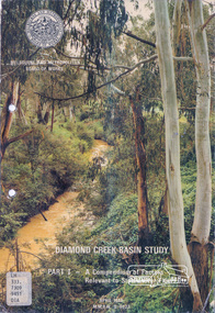
Book, Diamond Creek Basin Study. Part 1, A Compendium of Factors Relevant to Stormwater Flows, 1980
... ...railway culvert...Basin Studies are studies to evaluate water supply and demand and help ensure reliable water supplies by identifying strategies to address imbalances in water supply and demand. aerial photographs allendale road arthurs creek mine arthurs creek road bridge arthurs creek bald spur look-out bank protection bolton steet bridge street bridge bridge street bridges challenger street chute street construction coolaroo drive culvert deep creek diamond creek basin diamond creek region diamond creek diamond street bridge drainage works eltham lower park eltham town park eltham trestle bridge eltham west drains eltham erosion flood management floods footbridge glen katherine estate gold mining gum glade hurstbridge kangaroo ground kinglake escarpment kinglake national park latiners hat factory main road bridge main road masons falls melbourne metropolitan board of works, monash bridge mount sugarloaf nillumbik park orchards railway culvert railway line ramptons road real estate advertisement research creek st helena east drain st helena road st helena storm sewers stormwater sugarloaf-preston transfer main crossing susan street union mine village pond water flow watkins street wattletree road weidlich road wingrove park yarra river zig zag road water supply basin study Spiral Bound. 157 leaves in various foliations (some folded) : illustrated. ...Basin Studies are studies to evaluate water supply and demand and help ensure reliable water supplies by identifying strategies to address imbalances in water supply and demand.Spiral Bound. 157 leaves in various foliations (some folded) : illustrated. (some colour.), maps (some colour.)aerial photographs, allendale road, arthurs creek mine, arthurs creek road bridge, arthurs creek, bald spur look-out, bank protection, bolton steet, bridge street bridge, bridge street, bridges, challenger street, chute street, construction, coolaroo drive, culvert, deep creek, diamond creek basin, diamond creek region, diamond creek, diamond street bridge, drainage works, eltham lower park, eltham town park, eltham trestle bridge, eltham west drains, eltham, erosion, flood management, floods, footbridge, glen katherine estate, gold mining, gum glade, hurstbridge, kangaroo ground, kinglake escarpment, kinglake national park, latiners hat factory, main road bridge, main road, masons falls, melbourne metropolitan board of works, monash bridge, mount sugarloaf, nillumbik park, orchards, railway culvert, railway line, ramptons road, real estate advertisement, research creek, st helena east drain, st helena road, st helena, storm sewers, stormwater, sugarloaf-preston transfer main crossing, susan street, union mine, village pond, water flow, watkins street, wattletree road, weidlich road, wingrove park, yarra river, zig zag road, water supply, basin study -
 Tatura Irrigation & Wartime Camps Museum
Map - plan, Engineer for Contruction Railways Dept, Toolamba and Tatura Railway, 18 August 1879
... Existing buildings, dams (tanks), wells and railway culverts....Existing buildings, dams (tanks), wells and railway culverts. Toolamba and Tatura Railway Map - plan Engineer for Contruction Railways Dept. ...Original plan2 sheets stapled together, white paper. Plan of proposed railway line drawn in ink. Names of property owners transverse shown. Roads show. Existing buildings, dams (tanks), wells and railway culverts.Victorian Railways. signed by Engineer in ink.victorian railways plans -
 Sunshine and District Historical Society Incorporated
Document - Victorian Heritage Register Black Arch Rail Bridge Railway Culverts Sunshine Railway Signal Box & Hume & Hovell Cairn St Albans
... Letter to Brimbank City Council for a Heritage Centre in the Harvester Site dated 3 December 1994 Letter from Heritage Victoria for items for inclusion in the Victorian Heritage Register for Railway Culverts and 039 Sunshine Railway Signal Box and H040 Black Arch Rail Bridge and Hume & Hovell Cairn St Albans but advised only recommended for inclusion at a local planning scheme level. ...Sunshine Heritage Letter to Brimbank City Council for a Heritage Centre in the Harvester Site dated 3 December 1994 Letter from Heritage Victoria for items for inclusion in the Victorian Heritage Register for Railway Culverts and 039 Sunshine Railway Signal Box and H040 Black Arch Rail Bridge and Hume & Hovell Cairn St Albans but advised only recommended for inclusion at a local planning scheme level. ...Letter to Brimbank City Council for a Heritage Centre in the Harvester Site dated 3 December 1994 Letter from Heritage Victoria for items for inclusion in the Victorian Heritage Register for Railway Culverts and 039 Sunshine Railway Signal Box and H040 Black Arch Rail Bridge and Hume & Hovell Cairn St Albans but advised only recommended for inclusion at a local planning scheme level. Letter from Tom Rigg to Heritage Victoria requesting for items to be included Newspaper Article Herald Sun 18 June 2001 Inclusion as Heritage Place Trestle Bridge Arundel Road Keilor and HV McKay Memorial Gardens Anderson Road Sunshine. Recommendation for inclusion are Black Arch Rail Bridge Sunshine road Sunshine Railway Culvert Sydenham Road St Albans Railway Culvert Victoria Road Sydenham Sunshine Railway Signal Box Hampshire road Sunshine Hume & Hovell Cairn East Esplanade & Taylors road St Albans Victorian Heritage register Recommendation and determination on a nomination to the Victorian Heritage Register Black Arch rail bridge is not of sufficient cultural heritage Victorian Heritage register Recommendation and determination on a nomination to the Victorian Heritage Register Railway Culvert Sydenham Road is not of sufficient cultural heritage Victorian Heritage register Recommendation and determination on a nomination to the Victorian Heritage Register Railway culvert Victoria Road is not of sufficient cultural heritage Victorian Heritage register Recommendation and determination on a nomination to the Victorian Heritage Register Sunshine Railway Signal Box Hampshire Road is not of sufficient cultural heritage Victorian Heritage register Recommendation and determination on a nomination to the Victorian Heritage Register Hume and Hovell Cairn is not of sufficient cultural heritage Resolution re Sunshine Signal Box to write to PTC December 1997 Newspaper Atricle The Advocate 28th September 1999 - 1880s area listed for the Victorian Heritage Register Memoriam of Heritage Advice on Municipal Offices Alexander Avenue by Bryce Raworth Pty Ltdsunshine, heritage -
 Sunshine and District Historical Society Incorporated
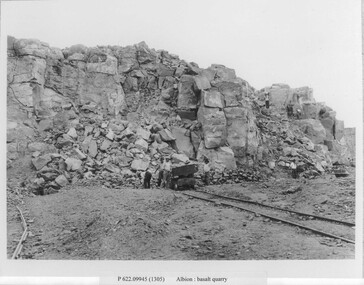
Photograph - Albion Quarry Photographs
... The quarry extracted high quality bluestone, ideal for road construction, railway ballast, culverts, bridges and public buildings and private homes. ...The quarry extracted high quality bluestone, ideal for road construction, railway ballast, culverts, bridges and public buildings and private homes. ...Albion Quarry began operations in 1888, and became one of the largest bluestone quarries in Australia, later it became the Sunshine municipal tip. In 1888, quarrying first began on the site by the Wales family. The quarry extracted high quality bluestone, ideal for road construction, railway ballast, culverts, bridges and public buildings and private homes. The site quickly became one of the most productive basalt quarries in the region. In 1907, the Albion Quarry Company was formed as a partnership between Alexander Wales, James Watter, Peter Rumpf, Thomas Adams, William Wright Wales and Alexander George Wales (later Sir George Wales, Lord Mayor of Melbourne) The company became the largest producer of quarry products in the Commonwealth. The quarry pit was, at one time, the largest in Australia. In January 1965, Boral acquired both Albion Quarry and Reid Quarry, merging them into Albion Reid Pty Ltd. Quarrying there continued until the late 1960s–early 1970s. After quarrying ceased, the enormous pit was used as the Sunshine municipal tip. Dumped into the hole included household waste, industrial waste, chemical waste, radioactive waste and large quantities of unknown fill. Dumping continued until 1990. In the 1990’s, a methane powered electricity plant was installed on the site, but it failed due to insufficient methane production. In 2019, the former quarry made national news due to ground contamination affecting 69 residential homes, 6 commercial properties and a community park. The site is now being reserved for the future Sunshine Energy Park and is awaiting redevelopment. This quarry is historically significant for its scale, its role in Melbourne’s infrastructure, and its later environmental legacy.These photographs document the initial phase of quarrying, featuring manual labour and transportation by horse and cart.Albion basalt quarryalbion quarry, ballarat road, albion, basalt, hulett street -
 Sunshine and District Historical Society Incorporated
Document - Heritage Places Formerly With the City Of Sunshine 13th July 2009, Sunshine and District Historical Society Inc, 13th July 2009
... Albans H038 Sunshine Signal Box Off Hampshire Road H039 Black Arch Rail Bridge Sunshine Road Sunshine H040 Sugar Gum Row Talmage Street Albion H042 Railway Culvert Sydenham Road St. Albans HO43 Sunshine Advocate Office 11 - 15 Sun Crescent Sunshine H051 Keigilo, now Sacred Heart Presbytery 4 Winifred Street St. ...Albans H038 Sunshine Signal Box Off Hampshire Road H039 Black Arch Rail Bridge Sunshine Road Sunshine H040 Sugar Gum Row Talmage Street Albion H042 Railway Culvert Sydenham Road St. Albans HO43 Sunshine Advocate Office 11 - 15 Sun Crescent Sunshine H051 Keigilo, now Sacred Heart Presbytery 4 Winifred Street St. ...This list of City of Sunshine heritage‑listed properties is protected because they demonstrate important aspects of the area’s history — industrial innovation, early settlement, worker housing, civic development, and significant Aboriginal cultural landscapes. Heritage Listed Reference Numbers: Sunshine - Deer Park area 6737 - Heritage Places Formerly With the City Of Sunshine 13th July 2009 Page 1.jpg Heritage Precincts Commonwealth Munitions Housing Estate HO H019 Concrete Housing Estate Leith Avenue Sunshine HO H020 ICI Residential Area Deer Park HO H021 Sunshine Commercial Heritage Area HO H022 McKay Housing Estate Durham Road HOC H023 McKay Housing Estate King Edward Avenue HOC H024 Railway Estate Sunshine HO H025 War Service Homes Heritage Area Sunshine HO H026 Heritage Place Massey Ferguson Complex Devonshire Road Sunshine H03 John Darling & Son Flour Mill 74 Sydney Street Albion H04 Rail Bridge (Albion Viaduct) Over Maribyrnong River HO5 Black Powder Mill Parklea Avenue And Grassy Point Road Cairnlea HO6 Foxley Lodge Farm And Its Drystone Walls 472A Boundary Road Derrimut H08 1 Corio Steet Sunshine H09 H.V. McKay Memorial Gardens HO10 H.V. McKay Offices 2 Devonshire Road Sunshine HO11 Main Outfall Sewer Brimbank (Brooklyn) HO13 Mt. Derrimut Homestead, Its Drystone Walls And Associated Buildings Including The Meteorological Centre Mt. Derrimut Road Derrimut H017 H. V. McKay Offices (Eastern portion of the complex) 2 Devonshire Road HO18 Albion VR DC Substation Talmage Street Albion H028 Pig And Calf Market 55 Market Road Brooklyn H029 Monsanto Chemicals Huntsman Chemical Co 455 Somerville Road Brooklyn H030 Deer Park Explosive Factories Complex Off Ballarat Road Deer Park H032 6737 - Heritage Places Formerly With the City Of Sunshine 13th July 2009 Page 2.jpg Heritage Place (Cont) Hume And Hovell Cairn Cnr Station Road And Ballarat Road Deer Park H034 Anderson Farm House 100 Taylors Road St. Albans HO36 Hume And Hovell Cairn East Esplanade St. Albans H038 Sunshine Signal Box Off Hampshire Road H039 Black Arch Rail Bridge Sunshine Road Sunshine H040 Sugar Gum Row Talmage Street Albion H042 Railway Culvert Sydenham Road St. Albans HO43 Sunshine Advocate Office 11 - 15 Sun Crescent Sunshine H051 Keigilo, now Sacred Heart Presbytery 4 Winifred Street St. Albans HO52 H.V. McKay Memorial Gates Anderson Road Sunshine H053 H.V. McKay Memorial Presbyterian Church Anderson Road Sunshine H054 Sam McKay House And Garden 147 Anderson Road Sunshine H055 Former Sunshine Technical School Derby Road Sunshine H056 Former Sunshine Girls Technical School Derby Road Sunshine H057 Pedestrian Footbridge Over Railway 1 Devonshire Road Sunshine H058 House At 48 Station Place Sunshine H061 ANZ Bank Former ES&A Bank 115 Durham Road Sunshine H063 Sunshine Metropolitan Fire Station And Flats 330 Hampshire Road Sunshine H064 Derrimut Hotel 132 Durham Road Sunshine H065 St. Mark's Anglican Church 49 Suns Crescent Sunshine H066 Robinson House 33 Sun Crescent Sunshine H067 St. Theresa Catholic Church & School 26 Adelaide Street Albion H070 Curacloe H071 Former Wunderlich Now West End Market 47 - 49 McIntyre Road Sunshine North H073 Selwyn Park Albion H074 Sunshine Baptist Church 42 Ridley Street & 16 Sydney Street Albion H075 Cameron House & Dairy H076 6737 - Heritage Places Formerly With the City Of Sunshine 13th July 2009 Page 3.jpg Heritage Place (Cont) Houses & Trees 22 - 24 Talmage Street Albion H077 Ford (Solomon Ford) Burke Road To Canning Street Avondale Heights H079 Lions House Of Sunshine 8 Watt Street Sunshine H080 Guiding Star Hotel 700 Geelong Road Brooklyn H081 Hunt Club Hotel 775 Ballarat Road Deer Park H082 Deer Park Hotel 760 Ballarat Road Deer Park H083 Deer Park Primary School No 1434 812 Ballarat Road Deer Park H084 Opie's Dairy 2 - 4 Egan Street Deer Park H086 St. John's Anglican Church & Hall 2 - 4 Miles Street Deer Park H087 Neale Road Ford 192 Neale Road Deer Park H088 Deer Park Hall 50 Station Road Deer Park H089 Sunshine Market 13 - 19 City Place Sunshine H091 House St. Albans Estate 16 Arthur Street St. Albans HO98 St. Albans Uniting Church (Formerly Presbyterian) 24 - 26 East Esplanade St. Albans HO99 St. George's Free Serbian Orthodox Church 6 Kate Street St. Albans HO101 Errington Reserve & Memorial Gardens 309A Main Road East St. Albans HO102 St. Albans Community Hall Youth Club 309A Main Road East St. Albans HO103 Methodist Church & Hall 32 Devonshire Road Sunshine H0105 Macedonian Community Centre 45 Fourth Avenue Sunshine H0106 Hannah McKay House 145 Anderson Road Albion HO107 6737 - Heritage Places Formerly With the City Of Sunshine 13th July 2009 Page 4.jpg Heritage Place (Cont) Chemist Shop 234 Hampshire Road Sunshine H0108 Sunshine Municipal Offices 6 - 18 Alexandra Avenue Sunshine H0109 Sunshine Primary School 3113 111 Derby Road Sunshine H0110 Standard Steel 12 - 16 Market Road Sunshine H0111 Our Lady of the Immaculate Conception Catholic Church 93 Monash Street Sunshine H0113 Parsons House 114 Moris Street Sunshine H0114 Our Lady's School Station Place Monash Street Sunshine H0115 Palmas 2 Tyler Street Sunshine H0116 St. Andrews Greek Orthodox Church (Greek Cypriot) 14 Simmie Street Sunshine West H0119 William McKay House 150 Durham Road Sunshine H0121 Albion Primary School No 4265 61 - 81 Adelaide Street Albion H0122 Ralph's Meatworks 690 Geelong Road Brooklyn H0123 Former Church of Christ 81 - 83 Hampshire Road Sunshine H0125 Former Masonic Lodge No 226 93 Hampshire Road Sunshine H0126 Sunshine Picture Theatre 126 - 128 Hampshire Road Sunshine H0127 Shops 193 - 199 Hampshire Road Sunshine H0130 Ukrainian Catholic Church 2 Holmes Street Ardeer H0132 Shops 207 - 219 Hampshire Road Sunshine H0133 Victorian Row House 25 Benjamin Street Sunshine H0134 Victorian Row House 29 Benjamin Street Sunshine H0135 Victorian Row House 31 Benjamin Street Sunshine H0136 Victorian Row House 33 Benjamin Street Sunshine H0137 Victorian Row House 35 Benjamin Street Sunshine H0138 50 Forrest Street Albion H0139 -
 Sunshine and District Historical Society Incorporated
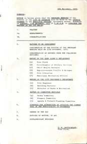
Administrative record - City of Sunshine - Commissioner Mr Alexander Alex George Gillon Collection 1976 - 1982 - Notice of ordinary meeting of the council 11th December 1979, City of Sunshine, 5th December 1979
... Huts Tottenham to Sunvale Primary School and Sunshine High School Prohibited Parking Ashley Street / Western Highway (Ballarat Road) Braybrook School Crossings Deer Park North Primary School Station Road Widening Melbourne Metropolitan Planning Scheme Amendment No 81 Part 4 88 Station Road Deer Park Traffic Signals Intersection Ashley Street / South Road Braybrook Declaration of Sewerage Area No 3885 Lots 1261 to 1244 Opie Road, Lots 1165 to 1148 Penfold Place, Lots 1174, 2219, 1147 to 135 and Lot 1262 Evergreen Avenue Albanvale Two-Day Hydraulic Course for Mechanics 28th - 29th November 1979 Proposed Pedestrian Operated Signals Western Highway (Ballarat Road) East of Darnley Street Braybrook Commonwealth Offices Near Devonshire Road and Martin Street Sunshine Proposed Traffic Signals Under Statcon Programme Ashley Street / Barkly Street Intersection Footscray West Load Limit Various Roads Stony Creek (Upper) Lysaghts Railway Culvert to Railway Reserve M.M.B.W. Western Reginal Depot St. ...Huts Tottenham to Sunvale Primary School and Sunshine High School Prohibited Parking Ashley Street / Western Highway (Ballarat Road) Braybrook School Crossings Deer Park North Primary School Station Road Widening Melbourne Metropolitan Planning Scheme Amendment No 81 Part 4 88 Station Road Deer Park Traffic Signals Intersection Ashley Street / South Road Braybrook Declaration of Sewerage Area No 3885 Lots 1261 to 1244 Opie Road, Lots 1165 to 1148 Penfold Place, Lots 1174, 2219, 1147 to 135 and Lot 1262 Evergreen Avenue Albanvale Two-Day Hydraulic Course for Mechanics 28th - 29th November 1979 Proposed Pedestrian Operated Signals Western Highway (Ballarat Road) East of Darnley Street Braybrook Commonwealth Offices Near Devonshire Road and Martin Street Sunshine Proposed Traffic Signals Under Statcon Programme Ashley Street / Barkly Street Intersection Footscray West Load Limit Various Roads Stony Creek (Upper) Lysaghts Railway Culvert to Railway Reserve M.M.B.W. Western Reginal Depot St. ...Notice of Ordinary Meeting of the Council 11th December 1979 Report of the Town Clerk's Department Report of the Town Clerk Melbourne and Metropolitan Board of Works Representation and Rate Rise Use of Sunshine Tip by City of Brunswick Variation to Agreement Maribyrnong Hall Use of Rooms as an Infant Welfare Centre and Library Acquisition of Lot 7 Van Ness Avenue Hume Pipes Proposed Variation to Separate Awards Proposed Sale of Surplus Land Porter Road Reserve, Raymond Street Reserve, Davey Street Reserve, Lewis Court Reserve, Empress Court / Harwood Close, Hilma Street Being the Discontinued Part of Charlotte Street, Hilma Street Being the Discontinued Part of Nina Street, Hilma Street Being the Discontinued Part of Eva Street, West Street Being the Discontinued Part of McLaughlin Street, West Street Being the Discontinued Part of Maxwell Street, West Street Being the Discontinued Part of Suspension Street, Lot 24 Corner Kosky Street and Killara Street and Land Between Lots 17 and 46 Glindon Avenue Transfer of Land from Council to Maribyrnong Timber & Buildings Supplies Road Construction Agreements Rosamond Road Tennis Club Request to Extend Usable Area Outside Court No 1 Rate Recovery Sale 27 Duke Street Proposed Lease Tottenham Technical School Report of the Rainbow Workshop Report of the Co-Ordinator of Welfare Services Sunshine Community Newsletter Victorian Housing Policy Review Family Dare Care Programme Community Youth Support Scheme Donation from Invicta Group Industries Pty Ltd for Welfare Projects Emergency Relief Funds West Sunshine Ethnic Community Club Child Care Co-Operative Report of the Chief Health Surveyor Railway Underpass Sunshine Railway Station Hours of Infant & Maternal Child Welfare Centres Health Act Registrations for 1980 Health Act Registrations Late Fee Health Act Registrations for 1979 Application for Transfer of Proprietorship of Premises Under the Health Act Health Surveyor's Conference Adelaide 1979 Report Report of the Superintendent Traffic & By-Laws Court Proceedings Sunshine Magistrate Court Disposal of Derelict Vehicles Dog Act Report of the City Librarian Bookmobile Sites 1980 Highpoint City Library Staff Hours Melton Library Staff Library Statistics 1st October 1978 to 30th September 1979 Melton Library Annual Report Report of the Municipal Recreation Officer January 1980 Holidays Programme Report of the City Engineer & Planner Alternative Strategies for Metropolitan Melbourne Prospects for Further Development in the Built-Up Areas of Melbourne Maribyrnong River Recreational Development New Anglers Hotel Amendment No 127 to the Melbourne Metropolitan Planning Scheme Proposed Amendment No 130 to the Melbourne Metropolitan Planning Scheme Planning Permit Application Extensions to Existing Warehouse Lots 6 & 7 Tottenham Parade Footscray West Planning Permit Application Child Care Services Centre Andrea Street St. Albans Planning Permit Application Services Premises Addition to Existing Petrol Filling Station South East Corner Geelong Road and Francis Street Brooklyn Planning Permit Application Amusement Parlour Highpoint West Shopping Centre Rosamond Road Maribyrnong Planning Permit Application Car Sales Yard South West Corner Ballarat Road and Hampshire Road Sunshine Planning Permit Application Consulting Room (Dental Clinic) Lots 9, 10 and Part 11 Main Road West St. Albans Planning Permit Warehouse Lot 3 Emu Road Maidstone Planning Permit Application Signs South East Corner Geelong Road and Francis Street Brooklyn Planning Permit Application Three Villa Units Lot 13 Hertford Road North East Corner of Rawson Avenue Planning Permit Application Kindergarten Rogers Reserve Lot 3 Sonley Street Maidstone Planning Permit Application Access for the Manoeuvring of Historical Military Vehicles Lot 43 Judge Street Sunshine Planning Permit Application Detached House Lot 217 Collenso Street Sunshine West Planning Permit Application Panel Beating Works South West Corner Cromer Avenue and Baldwin Avenue Sunshine North Planning Permit Application Furniture and Carpet Sales Corner of Geelong Road and Francis Street Brooklyn Planning Permit Application Office Extension Lot 1 & 2 Ballarat Road Braybrook Planning Permit Application Illuminated Sign Lot 37 Perth Avenue Albion Planning Permit Application Finance Officer Lot 3 Sun Crescent Sunshine Planning Permit Application Factory Lots 42 & 42 Western Avenue South East Corner of Fourth Avenue Sunshine Planning Permit Application Dental Surgery Lot 2 Neale Road Deer Park Planning Permit Application Detached House Lot 433 Carroll Street Deer Park Planning Permit Application Transport Depot Lot 2 Geelong Road Brooklyn Planning Permit Application Two Service Premises and Consulting Rooms Lots 2, 3 & 4 Glengala Road Sunshine West Planning Permit Application Office Extension to Transport Depot 1 Alick Road North West Corner of Kalingra Road Tottenham Planning Permit Application Warehouse Lot 7 McIntyre Road Sunshine North Planning Permit Application Store Extension Lot 1 Suffolk Road Sunshine North Planning Permit Application Temporary Commercial Vehicle Park Lot 2 Neale Road Deer Park Planning Permit Application Extension to Viewing Area of Tennis Courts Robert Barrett Reserve Rosamond Road Maribyrnong for Rosamond Tennis Club Planning Permit Application Amusement Parlour Lot 2 Disraeli Street St. Albans Planning Permit Application New & Used Cars Sales and Service Dealership Corner of Ballarat Road and Ashley Street Consolidation of Title Wattle Road and George Street Maidstone Consolidation of Title Lots 52 & 53 Judge Street Sunshine Plan of Transfer of Land from Council to Sunshine R.S.L. Dickson Street Sunshine Construction Works Corner Furlong Road and St. Albans Road St. Albans Strata Subdivision 86 Phoenix Street Sunshine North Strata Subdivision 136 - 140 Wright Street Sunshine Council Vehicle Fleet Energy and Cost Considerations Traffic Control Items Transport of Wide Loads R.A.A.F. Huts Tottenham to Sunvale Primary School and Sunshine High School Prohibited Parking Ashley Street / Western Highway (Ballarat Road) Braybrook School Crossings Deer Park North Primary School Station Road Widening Melbourne Metropolitan Planning Scheme Amendment No 81 Part 4 88 Station Road Deer Park Traffic Signals Intersection Ashley Street / South Road Braybrook Declaration of Sewerage Area No 3885 Lots 1261 to 1244 Opie Road, Lots 1165 to 1148 Penfold Place, Lots 1174, 2219, 1147 to 135 and Lot 1262 Evergreen Avenue Albanvale Two-Day Hydraulic Course for Mechanics 28th - 29th November 1979 Proposed Pedestrian Operated Signals Western Highway (Ballarat Road) East of Darnley Street Braybrook Commonwealth Offices Near Devonshire Road and Martin Street Sunshine Proposed Traffic Signals Under Statcon Programme Ashley Street / Barkly Street Intersection Footscray West Load Limit Various Roads Stony Creek (Upper) Lysaghts Railway Culvert to Railway Reserve M.M.B.W. Western Reginal Depot St. Albans Road Sunshine North Widening of Carriageway at Entrance Aycliffe Drive Pre-School and Infant Welfare Centre Tenders Depot Amenities Block Anderson Road Sunshine Alterations and Additions Ballarat Road Infant Welfare Centre Report of the Building Surveyor Building Over Easement Lots 37 & 38 Balfour Avenue Sunshine North Building On Flood Prone Land Lot 2 Navigator Street Maribyrnong Installation of Underground Tanks 810 Ballarat Road Deer Park Installation of Underground Tanks 146 Ashley Street Maidstone Siting of Building 17 Chestnut Drive St. Albans Siting of Building Lot 109 Ballarat Road Deer Parkhume pipe company, maribyrnong, rosamond road tennis club, rosamond road, van ness avenue, sunshine tip, maribyrnong hall, raleigh road, porter road reserve, porter road, raymond street reserve, raymond street, sunshine west, davey street reserve, davey street, lewis court reserve, lewis court, empress court, harwood close, hilma street, charlotte street, nina street, eva street, west street, mclaughlin street, maxwell street, ardeer, kosky street, killara street, glindon avenue, st. albans, tottenham technical school, south road, duke street, braybrook, invicta, west sunshine ethnic community club child care co-operative, sunshine railway station underpass, new anglers hotel, tottenham parade, footscray west, andrea street, geelong road, francis street, highpoint west shopping centre, ballarat road, hampshire road, sunshine, main road west, emu road, maidstone, hertford road, rawson avenue, rogers reserve, sonley street, judge street, collenso street, cromer avenue, baldwin avenue, perth avenue, albion, sun crescent, western avenue, fourth avenue, neale road, deer park, carroll street, glengala road, alick road, kalingra road, tottenham, mcintyre road, sunshine north, suffolk road, robert barrett reserve, disraeli street, wattle road, george street, sunshine r.s.l., dickson street, furlong road, st. albans road, phoenix street, wright street, sunvale primary school, sunshine high school, western highway, deer park north primary school, station road, opie road, penfold place, evergreen avenue, albanvale, darnley street, devonshire road, martin street, stony creek, aycliffe drive pre-school and infant welfare centre, aycliffe drive, balfour avenue, navigator street, chestnut drive -
 Sunshine and District Historical Society Incorporated
Administrative record - City of Sunshine - Commissioner Mr Alexander Alex George Gillon Collection 1976 - 1982 - Minutes of the ordinary meeting of council held on 11th Dec 1979, City of Sunshine, 11th December 1979
... Huts Tottenham to Sunvale Primary School and Sunshine High School Prohibited Parking Ashley Street / Western Highway (Ballarat Road) Braybrook School Crossings Deer Park North Primary School Station Road Widening Melbourne Metropolitan Planning Scheme Amendment No 81 Part 4 88 Station Road Deer Park Traffic Signals Intersection Ashley Street / South Road Braybrook Declaration of Sewerage Area No 3885 Lots 1261 to 1244 Opie Road, Lots 1165 to 1148 Penfold Place, Lots 1174, 2219, 1147 to 135 and Lot 1262 Evergreen Avenue Albanvale Two-Day Hydraulic Course for Mechanics 28th - 29th November 1979 Proposed Pedestrian Operated Signals Western Highway (Ballarat Road) East of Darnley Street Braybrook Commonwealth Offices Near Devonshire Road and Martin Street Sunshine Proposed Traffic Signals Under Statcon Programme Ashley Street / Barkly Street Intersection Footscray West Load Limit Various Roads Stony Creek (Upper) Lysaghts Railway Culvert to Railway Reserve M.M.B.W. Western Reginal Depot St. ...Huts Tottenham to Sunvale Primary School and Sunshine High School Prohibited Parking Ashley Street / Western Highway (Ballarat Road) Braybrook School Crossings Deer Park North Primary School Station Road Widening Melbourne Metropolitan Planning Scheme Amendment No 81 Part 4 88 Station Road Deer Park Traffic Signals Intersection Ashley Street / South Road Braybrook Declaration of Sewerage Area No 3885 Lots 1261 to 1244 Opie Road, Lots 1165 to 1148 Penfold Place, Lots 1174, 2219, 1147 to 135 and Lot 1262 Evergreen Avenue Albanvale Two-Day Hydraulic Course for Mechanics 28th - 29th November 1979 Proposed Pedestrian Operated Signals Western Highway (Ballarat Road) East of Darnley Street Braybrook Commonwealth Offices Near Devonshire Road and Martin Street Sunshine Proposed Traffic Signals Under Statcon Programme Ashley Street / Barkly Street Intersection Footscray West Load Limit Various Roads Stony Creek (Upper) Lysaghts Railway Culvert to Railway Reserve M.M.B.W. Western Reginal Depot St. ...Minutes of the Ordinary Meeting of Council held on 11th Dec 1979 Report of the Town Clerk's Department Report of the Town Clerk Melbourne and Metropolitan Board of Works Representation and Rate Rise Use of Sunshine Tip by City of Brunswick Variation to Agreement Maribyrnong Hall Use of Rooms as an Infant Welfare Centre and Library Acquisition of Lot 7 Van Ness Avenue Hume Pipes Proposed Variation to Separate Awards Proposed Sale of Surplus Land Porter Road Reserve, Raymond Street Reserve, Davey Street Reserve, Lewis Court Reserve, Empress Court / Harwood Close, Hilma Street Being the Discontinued Part of Charlotte Street, Hilma Street Being the Discontinued Part of Nina Street, Hilma Street Being the Discontinued Part of Eva Street, West Street Being the Discontinued Part of McLaughlin Street, West Street Being the Discontinued Part of Maxwell Street, West Street Being the Discontinued Part of Suspension Street, Lot 24 Corner Kosky Street and Killara Street and Land Between Lots 17 and 46 Glindon Avenue Transfer of Land from Council to Maribyrnong Timber & Buildings Supplies Road Construction Agreements Rosamond Road Tennis Club Request to Extend Usable Area Outside Court No 1 Rate Recovery Sale 27 Duke Street Proposed Lease Tottenham Technical School Report of the Rainbow Workshop Report of the Co-Ordinator of Welfare Services Sunshine Community Newsletter Victorian Housing Policy Review Family Dare Care Programme Community Youth Support Scheme Donation from Invicta Group Industries Pty Ltd for Welfare Projects Emergency Relief Funds West Sunshine Ethnic Community Club Child Care Co-Operative Report of the Chief Health Surveyor Railway Underpass Sunshine Railway Station Hours of Infant & Maternal Child Welfare Centres Health Act Registrations for 1980 Health Act Registrations Late Fee Health Act Registrations for 1979 Application for Transfer of Proprietorship of Premises Under the Health Act Health Surveyor's Conference Adelaide 1979 Report Report of the Superintendent Traffic & By-Laws Court Proceedings Sunshine Magistrate Court Disposal of Derelict Vehicles Dog Act Report of the City Librarian Bookmobile Sites 1980 Highpoint City Library Staff Hours Melton Library Staff Library Statistics 1st October 1978 to 30th September 1979 Melton Library Annual Report Report of the Municipal Recreation Officer January 1980 Holidays Programme Report of the City Engineer & Planner Alternative Strategies for Metropolitan Melbourne Prospects for Further Development in the Built-Up Areas of Melbourne Maribyrnong River Recreational Development New Anglers Hotel Amendment No 127 to the Melbourne Metropolitan Planning Scheme Proposed Amendment No 130 to the Melbourne Metropolitan Planning Scheme Planning Permit Application Extensions to Existing Warehouse Lots 6 & 7 Tottenham Parade Footscray West Planning Permit Application Child Care Services Centre Andrea Street St. Albans Planning Permit Application Services Premises Addition to Existing Petrol Filling Station South East Corner Geelong Road and Francis Street Brooklyn Planning Permit Application Amusement Parlour Highpoint West Shopping Centre Rosamond Road Maribyrnong Planning Permit Application Car Sales Yard South West Corner Ballarat Road and Hampshire Road Sunshine Planning Permit Application Consulting Room (Dental Clinic) Lots 9, 10 and Part 11 Main Road West St. Albans Planning Permit Warehouse Lot 3 Emu Road Maidstone Planning Permit Application Signs South East Corner Geelong Road and Francis Street Brooklyn Planning Permit Application Three Villa Units Lot 13 Hertford Road North East Corner of Rawson Avenue Planning Permit Application Kindergarten Rogers Reserve Lot 3 Sonley Street Maidstone Planning Permit Application Access for the Manoeuvring of Historical Military Vehicles Lot 43 Judge Street Sunshine Planning Permit Application Detached House Lot 217 Collenso Street Sunshine West Planning Permit Application Panel Beating Works South West Corner Cromer Avenue and Baldwin Avenue Sunshine North Planning Permit Application Furniture and Carpet Sales Corner of Geelong Road and Francis Street Brooklyn Planning Permit Application Office Extension Lot 1 & 2 Ballarat Road Braybrook Planning Permit Application Illuminated Sign Lot 37 Perth Avenue Albion Planning Permit Application Finance Officer Lot 3 Sun Crescent Sunshine Planning Permit Application Factory Lots 42 & 42 Western Avenue South East Corner of Fourth Avenue Sunshine Planning Permit Application Dental Surgery Lot 2 Neale Road Deer Park Planning Permit Application Detached House Lot 433 Carroll Street Deer Park Planning Permit Application Transport Depot Lot 2 Geelong Road Brooklyn Planning Permit Application Two Service Premises and Consulting Rooms Lots 2, 3 & 4 Glengala Road Sunshine West Planning Permit Application Office Extension to Transport Depot 1 Alick Road North West Corner of Kalingra Road Tottenham Planning Permit Application Warehouse Lot 7 McIntyre Road Sunshine North Planning Permit Application Store Extension Lot 1 Suffolk Road Sunshine North Planning Permit Application Temporary Commercial Vehicle Park Lot 2 Neale Road Deer Park Planning Permit Application Extension to Viewing Area of Tennis Courts Robert Barrett Reserve Rosamond Road Maribyrnong for Rosamond Tennis Club Planning Permit Application Amusement Parlour Lot 2 Disraeli Street St. Albans Planning Permit Application New & Used Cars Sales and Service Dealership Corner of Ballarat Road and Ashley Street Consolidation of Title Wattle Road and George Street Maidstone Consolidation of Title Lots 52 & 53 Judge Street Sunshine Plan of Transfer of Land from Council to Sunshine R.S.L. Dickson Street Sunshine Construction Works Corner Furlong Road and St. Albans Road St. Albans Strata Subdivision 86 Phoenix Street Sunshine North Strata Subdivision 136 - 140 Wright Street Sunshine Council Vehicle Fleet Energy and Cost Considerations Traffic Control Items Transport of Wide Loads R.A.A.F. Huts Tottenham to Sunvale Primary School and Sunshine High School Prohibited Parking Ashley Street / Western Highway (Ballarat Road) Braybrook School Crossings Deer Park North Primary School Station Road Widening Melbourne Metropolitan Planning Scheme Amendment No 81 Part 4 88 Station Road Deer Park Traffic Signals Intersection Ashley Street / South Road Braybrook Declaration of Sewerage Area No 3885 Lots 1261 to 1244 Opie Road, Lots 1165 to 1148 Penfold Place, Lots 1174, 2219, 1147 to 135 and Lot 1262 Evergreen Avenue Albanvale Two-Day Hydraulic Course for Mechanics 28th - 29th November 1979 Proposed Pedestrian Operated Signals Western Highway (Ballarat Road) East of Darnley Street Braybrook Commonwealth Offices Near Devonshire Road and Martin Street Sunshine Proposed Traffic Signals Under Statcon Programme Ashley Street / Barkly Street Intersection Footscray West Load Limit Various Roads Stony Creek (Upper) Lysaghts Railway Culvert to Railway Reserve M.M.B.W. Western Reginal Depot St. Albans Road Sunshine North Widening of Carriageway at Entrance Aycliffe Drive Pre-School and Infant Welfare Centre Tenders Depot Amenities Block Anderson Road Sunshine Alterations and Additions Ballarat Road Infant Welfare Centre Report of the Building Surveyor Building Over Easement Lots 37 & 38 Balfour Avenue Sunshine North Building On Flood Prone Land Lot 2 Navigator Street Maribyrnong Installation of Underground Tanks 810 Ballarat Road Deer Park Installation of Underground Tanks 146 Ashley Street Maidstone Siting of Building 17 Chestnut Drive St. Albans Siting of Building Lot 109 Ballarat Road Deer Park Orders of the Day Accounts for Payment as at 30th November 1979 Extraordinary Business Report of the Town Clerk Lease 2 - 4 Burton Crescent Report of the City Engineer & Planner Planning Permit Application Factory Extensions Raleigh Road Planning Permit Application Illuminated Sign City Place Planning Permit Application Factory with Garage and Carport Display and Sales McIntyre Road Planning Permit Application Extension to Existing Weighbridge, Security Officer's Shelter and Alteration in the Layput of the Site for the Proposed Trucks Reversing Course to the Off-Load Ramp Planning Permit Application Alterations to Shops St. Albans Road Planning Permit Application Amusement Parlour and Cafe Main Road West Planning Permit Application Place of Worship Vule Street St. Albans Planning Permit Application Factory Site Layout Berkshire Road Sunshine North Plan of Subdivision Gooding Street Planning Permit Application Specialist Stone Services Geelong Road Brookylnmaribyrnong hall, raleigh road, maribyrnong, van ness avenue, rosamond tennis club, rosamond road, duke street, sunshine north, sunshine tip, porter road reserve, porter road, raymond street reserve, raymond street, sunshine west, davey street reserve, davey street, lewis court reserve, lewis court, empress court, harwood close, hilma street, charlotte street, nina street, eva street, west street, mclaughlin street, maxwell street, suspension street, ardeer, kosky street, killara street, glindon avenue, st. albans, tottenham technical school, south road, braybrook, sunshine, invicta, west sunshine ethnic community club child care co-operative, maribyrnong river, anglers hotel, tottenham parade, footscray west, andrea street, geelong road, francis street, highpoint west shopping centre, ballarat road, hampshire road, main road west, emu road, maidstone, hertford road, rogers reserve, sonley street, judge street, collenso street, cromer avenue, baldwin avenue, perth avenue, albion, sun crescent, western avenue, fourth avenue, neale road, deer park, carroll street, glengala road, alick road, kalingra road, tottenham, mcintyre road, suffolk road, robert barrett reserve, disraeli street, ashley street, wattle road, george street, sunshine r.s.l., dickson street, furlong road, st. albans road, phoenix street, wright street, sunvale primary school, sunshine high school, western highway, deer park north primary school, station road, opie road, penfold place, evergreen avenue, albanvale, darnley street, devonshire road, martin street, stony creek, aycliffe drive pre-school and infant welfare centre, aycliffe drive, anderson road, ballarat road infant welfare centre, balfour avenue, navigator street, chestnut drive, city place, burton crescent, vule street, gooding street -
 Federation University Historical Collection
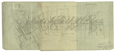
Plan, Ballarat Railway Plan, 1888, 27/02/1888
... .1) Copy of a Ballarat Railway Plan, running along Belford Street, from the Engineer in Chief's Office, Railway Department. It shows bridges, diversions, culverts and the following streets: Joseph Street, Lal Lal Street, Clayton Street, Belford Street, Rodier Street, trench Street, Stawell Street, Rodier Street, Belford Street, George Street, Eureka Street, Queen Street, Otway Street, Scott Parade, Ross Street, Chamberlain Street, Victoria Street, Water Street. ...Wellingtonia Gigantiea co Railway .1) Copy of a Ballarat Railway Plan, running along Belford Street, from the Engineer in Chief's Office, Railway Department. It shows bridges, diversions, culverts and the following streets: Joseph Street, Lal Lal Street, Clayton Street, Belford Street, Rodier Street, trench Street, Stawell Street, Rodier Street, Belford Street, George Street, Eureka Street, Queen Street, Otway Street, Scott Parade, Ross Street, Chamberlain Street, Victoria Street, Water Street. ....1) Copy of a Ballarat Railway Plan, running along Belford Street, from the Engineer in Chief's Office, Railway Department. It shows bridges, diversions, culverts and the following streets: Joseph Street, Lal Lal Street, Clayton Street, Belford Street, Rodier Street, trench Street, Stawell Street, Rodier Street, Belford Street, George Street, Eureka Street, Queen Street, Otway Street, Scott Parade, Ross Street, Chamberlain Street, Victoria Street, Water Street. Allotments owned by Tulloch and McLaren, J. Wilson, J. McCarthy, Mrs P. Glynn, E. Ratcliffe, soap works, Orphan Asylum .2) Copy of a plan relating to the construction of the Ballarat Railway Line. It includes shafts for the following companies: South Extended Co, Black Hill; Parade Co.; Black Hill Co.; Spanhake Co. Shaft; Black Hill South Co.; Wellingtonia Gigantiea Co., and the old workings of the Welllingtonia Gigantea Co,ballarat railway plan, belford street, lal lal street, clayton street, rodier street, trench street, south extended co., black hill, parade co., spanhake co. shaft, black hill south co., wellingtonia gigantiea co, railway -
 Federation University Historical Collection
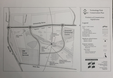
Map, Matthew Cibson, University of Ballarat Centre for Environmental Management, Ballarat Technology Park Conservation Plan, 1997, 02/1997
... Map showing the Ballarat Technlogy Camp, Greenhill Enterprise Centre, Canadian Wetlands. hand-made brick culvert sleepers, Ballarat-Buninyong Railway Line, IBM Global Services, early wooden bridge, Canadian Creek, Gear Avenue. ...The Ballarat Technology Park is on the Federation University Mount Helen Campus ballarat technology park canadian wetlands greenhill enterprise centre brick cultert railway ballarat-buninyong railway Map showing the Ballarat Technlogy Camp, Greenhill Enterprise Centre, Canadian Wetlands. hand-made brick culvert sleepers, Ballarat-Buninyong Railway Line, IBM Global Services, early wooden bridge, Canadian Creek, Gear Avenue. ...The Ballarat Technology Park is on the Federation University Mount Helen CampusMap showing the Ballarat Technlogy Camp, Greenhill Enterprise Centre, Canadian Wetlands. hand-made brick culvert sleepers, Ballarat-Buninyong Railway Line, IBM Global Services, early wooden bridge, Canadian Creek, Gear Avenue. ballarat technology park, canadian wetlands, greenhill enterprise centre, brick cultert, railway, ballarat-buninyong railway -
 Eltham District Historical Society Inc
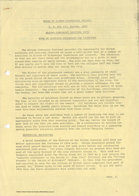
Document, Russell Yeoman, Tour of Historic Buildings and Locations, 1978
... RAILWAY BRIDGE The timber trestle bridge over the Diamond Creek was built in 1901. Whilst all of its timbers have been replaced at various times over the years the only change to its character has been the addition of pylons and wiring for electric trains in 1923. It is one of very few similar bridges remaining in the metropolitan area. In 1976 a proposal to replace the bridge with an earth embankment and large culvert...RAILWAY BRIDGE The timber trestle bridge over the Diamond Creek was built in 1901. Whilst all of its timbers have been replaced at various times over the years the only change to its character has been the addition of pylons and wiring for electric trains in 1923. It is one of very few similar bridges remaining in the metropolitan area. In 1976 a proposal to replace the bridge with an earth embankment and large culvert ...Self guided heritage tour information produced by the Shire of Eltham Historical Society for 1978 Eltham Community Festival of 36 locations each numbered on accompanying map. Locations and detail provided current to 1978: 1. ELTHAM SHOPPING CENTRE Whilst very little remains in the centre of historical importance, this area has interest as the "village" which developed over many years following the opening of the railway from Melbourne in 1902. Previously the shopping centre had been spread out over a long length of Main Road to the south. Shops have been continuously demolished or remodelled and the majority of buildings date from the 1950's or later. The recently erected Post Office replaced the "old" Post Office opened on the same site only in 1958. 2. WOOLWORTHS ELTHAM VILLAGE Part of the site of this modern shopping development was occupied by the former Eltham Shire Offices and Hall. The hall was paid for by public subscription whilst the Council raised a loan for the offices. The combined building was opened in 1941. It served as office and Council meeting place until 1965 and as the hall until its demolition in 1970. 3. ELTHAM WAR MEMORIAL The complex of buildings adjoining the present Shire Offices were financed by public subscription as a Memorial following World War II. Their construction and for many years their operation was organised by the now disbanded Eltham War Memorial Committee. The original buildings were the; Infant Welfare Centre, Children’s Library (now War Memorial Hall and Dental Clinic) and Kindergarten. In later years the Elderly Citizens Club was built at the rear. 4. ELTHAM SHIRE OFFICES These offices were opened in 1965 and extended in 1971 to provide additional office accommodation and the Eltham Library. They represent the last of a long line of offices and meeting places of the Eltham Shire Council and its predecessor the Eltham District Road Board. The building occupies the former site of Shillinglaw Cottage. The three tall cypress trees which stood in front of the Cottage have been retained as a feature of the office surrounds. 5. OUR LADY'S CHURCH AND SCHOOL The Catholic Church and School complex opposite the Shires Offices shows a number of stages in the development of Eltham township. The recently constructed church adjoins its predecessor (now the parish centre). Many years ago the Catholic Church was located opposite Wingrove Park and the present central site follows the northerly drift of the township. 6. SHILLINGLAW COTTAGE The Cottage was built in 1859 by George Stebbing, a local builder who was responsible for a number of other prominent buildings in the area. Its removal from the site of the Shire Offices and re-erection on the present site was financed by public subscription. It is built of handmade bricks laid in Flemish Bond with an unusual design featuring burnt "leader" bricks over the whole facade. The Cottage is occupied by Eltham Fleececrafts and will be open during the Festival and at other times during weekends. It is classified by the National Trust. 7. RAILWAY BRIDGE The timber trestle bridge over the Diamond Creek was built in 1901. Whilst all of its timbers have been replaced at various times over the years the only change to its character has been the addition of pylons and wiring for electric trains in 1923. It is one of very few similar bridges remaining in the metropolitan area. In 1976 a proposal to replace the bridge with an earth embankment and large culvert pipes was abandoned following community protests. The bridge, however, remains under threat because of the necessity for future deuplication of the railway line. 8. ELTHAM CENTPAL PARK The area between the railway and the creek has for many years been used as a park which included Eltham' s main football oval. The access road, Panther Place is named after Eltham's team playing in the Diamond Valley League. In recent years a large area extending to Bridge Street and locally known as the Town Park has been landscaped and added to the area. The excellent blending of the park with the natural landscape of the creek valley has earned a National Trust Landscape Classification. 9. OLD BAKERY On the southern corner of York Street and Main Road is an old house with a shop front which was for many years the local baker's shop. The brick bakery at the rear is of somewhat later vintage than the house. 10. BRIDGE STREET CUTTING Before reconstruction of Main Road this intersection had deep cutting embankments on all four corners, forming a distinctive feature of the entrance to Eltham. Roadworks and private development have levelled the land on the low side of the road. A memorial to the Eltham soldiers of World War I which was located at the north-western corner is now situated at the Eltham R.S.L. 11. HILLTOP MILK BAR For many years this was the site of the Eltham Post Office under the control of the Hunniford family and later their descendants the Burgoynes. It was transferred to this site in 1855, although at that time the building apparently fronted Bridge Str e et. The site contained Eltham's first telephone exchange. The post office was relocated in 1954 but the shop was operated until recently by the Burgoyne family who still own the surrounding land. 12. UNITING CHURCH and former C.B.A. BANK The former Methodist Church was built in 1880 by George Stebbing. The Sunday School extension was built in 1929 and there have been more recent extensions. The adjoining opportunity shop was built as a bank in 1874 and purchased by the Methodist Church in 1954. 13. R.S.L. HALL, TELEPHONE EXCHANGE These relatively recent buildings occupy the site of a row of shops forming part of the early ribbon of business development along Main Road. In front of the R.S.L. building is the World War I Memorial relocated from the corner of Bridge Street and Main Road. 14. ELTHAM COMMUNITY CENTRE Australia's first mudbrick "community building" was opened in April this year. Part of the site of the building was purchased in 1856 by Henry Dendy (of Brighton fame). At the rear of the land near the creek was a steam flour mill whilst Dendy's house was at the Main Road frontage of the land. His purchase totalled about 2 Ha (5 acres) and included land on the opposite side of Maria Street (Main Road). Dendy became a prominent member of the Eltham community and served one term as President of the Eltham District Road Board. In 1867 Dendy sold his land and business to William Ford of Malmsbury and shifted to Walhalla. The avenue of trees leading past the Community Centre to the creek may well have bordered the track to the mill. 15. ELTHAM HOTEL The original part of this hotel was built in 1927 following the burning of the former Watson's Eltham Hotel on the same site. The car park on the opposite side of Main Road was also the site of a hotel variously known over the years as; the Fountain of Friendship, the Fountain and the Evelyn Arms. As the Fountain of Friendship it was the first meeting place of the Eltham District Road Board in 1856. 16. ST. MARGARET'S CHURCH, PITT STREET In 1860 Henry Dendy was appointed Chairman of a committee to establish a church of England in Eltham. He donated part of his land in Pitt Street and in 1861 the church was opened. It was built by George Stebbing and remains in a well preserved state today. Th adjoining old vicarage is now named Dendy Hou se. A new mudbrick church hall is under construction on the site. The church and Dendy House are now listed on the Register of Historic Buildings. 17. NO. 86 PITT STREET Cottage built by George Stebbing and believed to be his home for some years in the 1850s. 18. LIVING AND LEARNING CENTRE The house was built in the 1850s with the kitchen at the front being added about 40 years later. By the creek below the house a number of early Eltham industries were located. These included a tannery and a brewery. 19. ELTHAM COURT HOUSE A Court of Petty Sessions was established in Eltham in 1858 and the present building dates from 1860. It is the oldest public building remaining in Eltham. In its early days the building was used as the meeting place and office of the Eltham District Road Board and as an overflow classroom for the local school. The Court House has been classified by the National Trust. The citation states that it is an example of the simple form of early brick Court House with gabled roof and porch. 20. LANDS DEPARTMENT OFFICE This building is the former police station and is probably of about the same age as the Court House. The lockup at the rear has been demolished but the old stables remain as garages. A licence was first granted for a police station at Eltham in 1856. 21. JARROLD COTTAGE The old Cottage opposite Dalton Street was formerly owned by the Jarrold family. Early records indicate that this was the building leased from the Jarrolds as a temporary police station prior to construction of the building on the corner of Brougham Street. The small building on the corner of the property was used as a boot repairer's shop. The elevated studio at the rear is a more recent construction by the present owners. 22. STATE SCHOOL RESIDENCE Erected in 1891 23. WINGROVE COTTAGE This building fills an important place in the history of Eltham and is now used as a medical clinic. It was built in 1858 for Charles S. Wingrove who was Secretary to the Eltham District Road Board and Shire Council from 1858 to 1904. During part of this period he was also Shire Engineer and was Secretary to the Heidelberg Road Board. The house was used as the office of the Board and Council for many years. Wingrove is buried in the cemetery at St. Helena. 24. WINGROVE PARK The parkland opposite Wingrove Cottage has been named after Charles Wingrove. The old Manna Gums are an outstanding feature of the park. 25. ELTHAM FRI.MARY SCHOOL NO. 209 The school first opened in the slab building in 1855 and operated from the present site since 1857. The oldest part of the present school is the stone building erected in 1876. The first school teacher, David Clark remained at the school until 1888. This school is the government township and has always been known as the Eltham School. An earlier school (no.371) known as Little Eltham School operated in Swan Street from 1853 to 1872. 26. "SHOESTRING" This house was built for school teacher David Clark. It has been extensively extended in recent years but the extensions do not detract from the character of the older part of the building. 27. ELTHAM CEMETERY The cemetery contains the graves of many of the district's pioneers . 28. MONTSALVAT This unique complex of buildings was commenced in 1935 by the late Justus Jorgensen and its development has extended over many years. Montsalvat has exerted a significant impact on Eltham The earth and stone construction of many of the buildings has influenced local architecture to a great extent and it has served as a "nerve centre" of the local artistic community. Montsalvat is open to the public for a small charge. 29. MAIN ROAD BRIDGE This location has been the main crossing of Diamond Creek since the earliest days of settlement. The present concrete bridge was erected in 1925 .and was preceded by a number of timber bridges. 30. ELTHAM LOWER PARK This park, being an unusually large flat area for Eltham, was originally the local racecourse. Horse races were held here from 1855 and the area was gazetted as a reserve for a racecourse and recreation reserve in 1857. The park is well known as a venue for school "bird days" and more recently as the site of the Diamond Valley Railway. This miniature railway features scale models of modern and old locomotives and rolling stock and has operated on this site since 1961 . Before that the railway operated at Chelsworth Park, Ivanhoe. 31. FALKINER HOUSE Frederick Falkiner was one of the earliest settlers in the Eltham township area and occupied a substantial leasehold prior to the first land sales. Early records show that Falkiner was the subject of a number of complaints from his neighbours but he has nevertheless been considered a prominent enough citizen to have a street named for him. This house was the home of Evelyn (Ely) Falkiner a member of Frederick's family. 32. WEST HOUSE Behind the large house on the hill is an early house built by the West family. This was relocated from a site near the front of the land by the present owner Mr. Fabbro. 33. FALKINER HOUSE This very old house is believed to have been the home of Frederick and may have been Eltham's first post office. Falkiner was the first post master for a short period. in 1854/55. 34. WITHERS HOUSE This house was the home of famous artist Walter Withers who shifted here from Heidelberg in 1903. 35. ELTHAM HIGH SCHOOL This school celebrated its jubilee this year, having commenced as the Eltham Higher Elementary School 50 years ago. 36. DIAMOND CREEK FOOTWAY If returning from the High School to the town centre the footpath by the bank of the Diamond Creek provides a pleasant route to finish your walk. The creek is a major tributary of the Yarra River. Together with its own major tributaries Arthurs Creek and Running Creek it commences on the southern slopes of the Dividing Range at Kinglake. It gives the name Diamond Valley to an area extending well beyond its actual drainage catchment.Recognition of the significance of various landmarks to the history of the Eltham community as of 1978‘shoestring’, 1978, bridge street cutting, burgoyne store, c.b.a. bank, diamond creek trail, eltham cemetery, eltham central park, eltham community centre, eltham community festival, eltham court house, eltham festival, eltham high school, eltham hotel, eltham lower park, eltham primary school, eltham railway trestle bridge, eltham shire offices, eltham shopping centre, eltham state school no. 209, eltham village, eltham war memorial, falkiner house, heritage trail, hilltop milk bar, jarrold cottage, lands department office, living, living and learning centre, main road bridge, montsalvat, old bakery, our eltham artistic recollections, our lady help of christian’s church, our lady help of christian’s primary school, pitt street, post office, r.s.l. hall, shillinglaw cottage, st margaret’s church, state school residence, stebbing cottage, telephone exchange, uniting church, west house, wingrove cottage, wingrove park, withers house, woolworths -
 Eltham District Historical Society Inc
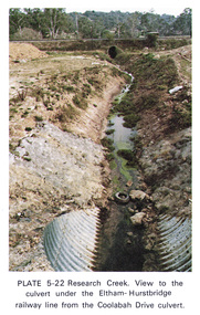
Work on paper (Sub-Item) - Photograph, Research Creek. View to the culvert under the Eltham-Hurstbridge railway line from the Coolabah Drive culvert
... View to the culvert under the Eltham-Hurstbridge railway line from the Coolabah Drive culvert...culvert...Eltham Hurstbridge Railway...View to the culvert under the Eltham-Hurstbridge railway line from the Coolabah Drive culvert, Eltham...View to the culvert under the Eltham-Hurstbridge railway line from the Coolabah Drive culvert, Eltham eltham research creek Coolabah Drive culvert Eltham Hurstbridge Railway drain Image printed on A4 page from 04997 Diamond Creek Basin Study, 1980 Research Creek. ...Colour photograph of Research Creek. View to the culvert under the Eltham-Hurstbridge railway line from the Coolabah Drive culvert, Elthameltham, research creek, coolabah drive, culvert, eltham hurstbridge railway, drain -
 Eltham District Historical Society Inc
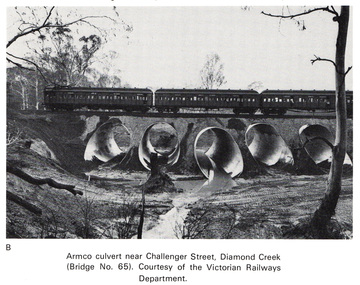
Work on paper (Sub-Item) - Photograph, Armco culvert near Challenger Street, Diamond Creek
... A passenger train crosses Victorian Railways Bridge No 65 near Challenger Street, Diamond Creek. A series of steel culverts or tunnels carrying a stream have been constructed beneath the railway bridge....A passenger train crosses Victorian Railways Bridge No 65 near Challenger Street, Diamond Creek. A series of steel culverts or tunnels carrying a stream have been constructed beneath the railway bridge. bridge culvert train Challenger Street Image printed on A4 page from 04997 Diamond Creek Basin Study, 1980 Armco culvert near Challenger Street, Diamond Creek Work on paper Photograph ...Black and white photograph. A passenger train crosses Victorian Railways Bridge No 65 near Challenger Street, Diamond Creek. A series of steel culverts or tunnels carrying a stream have been constructed beneath the railway bridge.bridge, culvert, train, challenger street -
 Eltham District Historical Society Inc
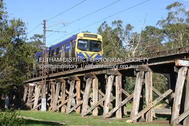
Photograph - Digital Photograph, Alan King, Eltham Railway Trestle Bridge, 28 December 2007
... The Victorian Railways proposed to replace the bridge with an earth embankment and large culverts to avoid maintenance problems and fire. ...The Victorian Railways proposed to replace the bridge with an earth embankment and large culverts to avoid maintenance problems and fire. ...Covered under National Trust of Australia (Victoria) State Significance and Heritage Overlay, Nillumbik Planning Scheme. Published: Nillumbik Now and Then / Marguerite Marshall 2008; photographs Alan King with Marguerite Marshall.; p103 The Eltham railway trestle bridge is the only one of its kind still regularly used in Melbourne’s metropolitan railway network. Opened in 1902, it is also one of Victoria’s very few timber rail bridges that still carries trains.1 The bridge is part of the railway line extension from Heidelberg - extended to Hurstbridge in 1912. This extension resulted in one of the greatest social changes experienced in Eltham Shire, as it considerably lessened its isolation attracting tourists, artists and suburban commuters particularly after World War Two.2 The bridge has been classified by the National Trust as historically, scientifically, aesthetically and socially significant at state level. But this has not always been recognised, and in 1977, locals fought to save it from destruction. The Victorian Railways proposed to replace the bridge with an earth embankment and large culverts to avoid maintenance problems and fire. This was rejected by the Eltham Council who protested that the bridge helped maintain the area’s rural character, historic link and beauty, as well as avoiding possible serious flooding on the flood plain if a culvert was blocked. The bridge stands as part of a National Trust classified landscape which includes the Alistair Knox Park, named after the local conservationist and architect who helped to make Eltham famous for its mud-brick houses. The landscape includes tall and spreading manna gums and candlebarks, and the historic Shillinglaw Cottage. Artist Walter Withers, one of the Heidelberg School of painters, painted the bridge early in the 20th century. The 38 span single-track railway bridge over creek and road has 34 timber-beam spans and four steel-joist spans, supported by four-pile timber piers and timber abutments. It has almost 200m of timber deck. All of the timbers have been replaced over the years, but the only change to the bridge’s character was the addition of pylons and wiring for electric trains in 1923. A petition for a railway to the shire was first made in 1883. A large deputation of local citizens to the Commissioner of Railways proposed a route passing through Alphington to midway between Greensborough and Eltham up the Diamond Creek valley towards Queenstown and Kinglake. As a result the Princes Bridge-Heidelberg Railway was opened in 1888. From 1888 locals demanded a railway extension. Kangaroo Ground farmers in particular, led by Shire Councillor and Member for Evelyn, Ewen Cameron, said it would assist local farmers and orchardists send their produce to the Melbourne market. In 1890, before the severe economic Depression, an extension of the line to Hurst’s Bridge (now Hurstbridge) was included in a new Railways Bill. The parliamentary delegations were regaled with a banquet at Hurst’s barn and entertained by the Diamond Creek Brass Band, but the extension was abandoned when the Depression struck in 1892-1893. The extension of the railway to Eltham, completed in 1902, was one of the few built in those hard times. That is why the Eltham timber-trestle railway bridge is a rare example of a broad-gauge rail bridge constructed between 1893 and 1910. At the opening, despite persistent drizzle, 300 children waving flags and banners were among the large crowd welcoming the first train, carrying official dignitaries, to Eltham. It had taken 24 years to bring the railway to Eltham. From then Eltham became a popular destination for outings. Mr Orford of Eltham recalled that after the railway came to Eltham ‘the craze for picnics on weekends and holidays began…. During the wattle season, wattle trains came to Eltham frequently. The visitors roamed the creek pulling great armfuls of wattle blossom to take back with them to Melbourne’.3 In 1926 the railway line was electrified as part of the metropolitan rail network. But the Victorian Railways decided not to complete the formerly planned Diamond Valley Railway to Queenstown (now St Andrews) and Kinglake.This collection of almost 130 photos about places and people within the Shire of Nillumbik, an urban and rural municipality in Melbourne's north, contributes to an understanding of the history of the Shire. Published in 2008 immediately prior to the Black Saturday bushfires of February 7, 2009, it documents sites that were impacted, and in some cases destroyed by the fires. It includes photographs taken especially for the publication, creating a unique time capsule representing the Shire in the early 21st century. It remains the most recent comprehenesive publication devoted to the Shire's history connecting local residents to the past. nillumbik now and then (marshall-king) collection, eltham railway trestle bridge, eltham trestle bridge -
 Eltham District Historical Society Inc
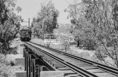
Photograph, George Coop, Single Motor Carriage (Red Rattler) Tait train heading for Hurstbridge about to cross over the Diamond Creek just north of Allendale Road, c.December 1980, 1980
... The derailment guard rail is intended to prevent severe derailment and to keep errant trains in line with track when going over culverts or similar should they become derailed. 471m, allendale road, derailment guard rail, diamond creek, hurstbridge line, railway bridge, red rattler, red rattler single carriage, single motor carriage, tait train Digital TIFF file Scan of 35mm Ilford FP4 black and white transparency Single Motor Carriage (Red Rattler) Tait train heading for Hurstbridge about to cross over the Diamond Creek just north of Allendale Road, c.December 1980 Photograph George Coop ...The derailment guard rail is intended to prevent severe derailment and to keep errant trains in line with track when going over culverts or similar should they become derailed.Digital TIFF file Scan of 35mm Ilford FP4 black and white transparency471m, allendale road, derailment guard rail, diamond creek, hurstbridge line, railway bridge, red rattler, red rattler single carriage, single motor carriage, tait train -
 Eltham District Historical Society Inc
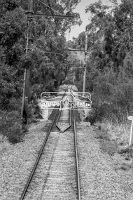
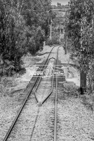
Photograph, George Coop, Derailment guard rails on the Hurstbridge line as the track crosses the Diamond Creek just north of Allendale Road, Diamond Creek, 6 December 1980, 1980
... The device pictured is intended to prevent severe derailment and to keep errant trains in line with track when going over culverts or similar should they become derailed Allendale Road, Derailment guard rail, Diamond Creek, Railway Bridge Digital TIFF file Scan of 35mm Ilford FP4 black and white transparency Derailment guard rails on the Hurstbridge line as the track crosses the Diamond Creek just north of Allendale Road, Diamond Creek, 6 December 1980 Photograph George Coop ...The device pictured is intended to prevent severe derailment and to keep errant trains in line with track when going over culverts or similar should they become derailedDigital TIFF file Scan of 35mm Ilford FP4 black and white transparencyallendale road, derailment guard rail, diamond creek, railway bridge -
 Eltham District Historical Society Inc
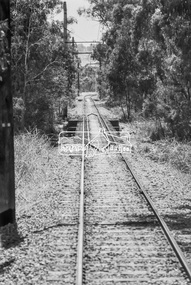
Photograph, George Coop, Derailment guard rails on the Hurstbridge line as the track crosses the Diamond Creek just north of Allendale Road, Diamond Creek, 6 December 1980, 1980
... The device pictured is intended to prevent severe derailment and to keep errant trains in line with track when going over culverts or similar should they become derailed allendale road, derailment guard rail, diamond creek, railway bridge Digital TIFF file Scan of 35mm Ilford FP4 black and white transparency Derailment guard rails on the Hurstbridge line as the track crosses the Diamond Creek just north of Allendale Road, Diamond Creek, 6 December 1980 Photograph George Coop ...The device pictured is intended to prevent severe derailment and to keep errant trains in line with track when going over culverts or similar should they become derailedDigital TIFF file Scan of 35mm Ilford FP4 black and white transparencyallendale road, derailment guard rail, diamond creek, railway bridge -
 Eltham District Historical Society Inc
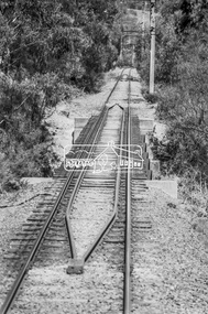
Photograph, George Coop, Derailment guard rails on the Hurstbridge line as the track crosses the Diamond Creek just north of Allendale Road, Diamond Creek, 6 December 1980, 1980
... The device pictured is intended to prevent severe derailment and to keep errant trains in line with track when going over culverts or similar should they become derailed allendale road, derailment guard rail, diamond creek, railway bridge Digital TIFF file Scan of 35mm Ilford FP4 black and white transparency Derailment guard rails on the Hurstbridge line as the track crosses the Diamond Creek just north of Allendale Road, Diamond Creek, 6 December 1980 Photograph George Coop ...The device pictured is intended to prevent severe derailment and to keep errant trains in line with track when going over culverts or similar should they become derailedDigital TIFF file Scan of 35mm Ilford FP4 black and white transparencyallendale road, derailment guard rail, diamond creek, railway bridge -
 Eltham District Historical Society Inc
Photograph, George Coop, Derailment guard rails on the Hurstbridge line as the track crosses the Diamond Creek just north of Allendale Road, Diamond Creek, 6 December 1980, 1980
... The device pictured is intended to prevent severe derailment and to keep errant trains in line with track when going over culverts or similar should they become derailed allendale road, derailment guard rail, diamond creek, railway bridge Digital TIFF file Scan of 35mm Ilford FP4 black and white transparency Derailment guard rails on the Hurstbridge line as the track crosses the Diamond Creek just north of Allendale Road, Diamond Creek, 6 December 1980 Photograph George Coop ...The device pictured is intended to prevent severe derailment and to keep errant trains in line with track when going over culverts or similar should they become derailedDigital TIFF file Scan of 35mm Ilford FP4 black and white transparencyallendale road, derailment guard rail, diamond creek, railway bridge -
 Eltham District Historical Society Inc
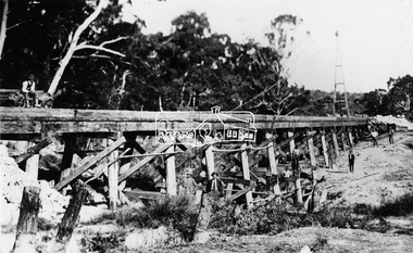
Photograph, Railway Bridge construction between Eltham and Hurstbridge, c.1912
... railway was extended from Eltham to Hurstbridge in 1912. This bridge is most likely near Allendale Road, Diamond Creek. It was one of four original trestle bridges in the stretch north of Allendale Road, which were all burnt out in January 1969 (replaced by two steel bridges and two corrugated iron culverts)....railway was extended from Eltham to Hurstbridge in 1912. This bridge is most likely near Allendale Road, Diamond Creek. It was one of four original trestle bridges in the stretch north of Allendale Road, which were all burnt out in January 1969 (replaced by two steel bridges and two corrugated iron culverts). ...The railway was extended from Eltham to Hurstbridge in 1912. This bridge is most likely near Allendale Road, Diamond Creek. It was one of four original trestle bridges in the stretch north of Allendale Road, which were all burnt out in January 1969 (replaced by two steel bridges and two corrugated iron culverts).This photo forms part of a collection of photographs gathered by the Shire of Eltham for their centenary project book,"Pioneers and Painters: 100 years of the Shire of Eltham" by Alan Marshall (1971). The collection of over 500 images is held in partnership between Eltham District Historical Society and Yarra Plenty Regional Library (Eltham Library) and is now formally known as the 'The Shire of Eltham Pioneers Photograph Collection.' It is significant in being the first community sourced collection representing the places and people of the Shire's first one hundred years.Digital image One 4 x 5 inch B&W negative One 9 x 12.5 cm printshire of eltham pioneers photograph collection, hurstbridge, allendale road, hurstbridge railway extension, railway bridge, railway line construction, trestle bridge, diamond creek (creek) -
 Eltham District Historical Society Inc
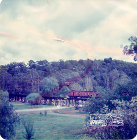
Photograph, Alice Elwers, Eltham Railway Bridge, 1976
... In 1976 when this was image was taken, Victorian Railways commenced works under the bridge to replace it with an earth embankment and large culvert pipes. ...In 1976 when this was image was taken, Victorian Railways commenced works under the bridge to replace it with an earth embankment and large culvert pipes. ...View of the Eltham Railway trestle bridge near Eltham Town Park with a train either approaching or leaving Eltham Station. A Tait 'red rattler' train is on the railway. The railway was commenced in 1900 and opened in 1902. It crosses the Diamond Creek on a timber trestle bridge just below where the Eltham Library stands today to the right on this view. The line was electrified in 1923. It is one of the few remaining similiar bridges remaining in Victoria. In 1976 when this was image was taken, Victorian Railways commenced works under the bridge to replace it with an earth embankment and large culvert pipes. This was abandoned following pressure from the Shire of Eltham and community protests. Colour photographbridges, railways, eltham, trestle bridge, eltham town park -
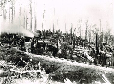 Otway Districts Historical Society
Photograph, Victorian Railways, Between Devitt Bros. Siding & Ditchley, 1901, 1901
... Construction of the Colac-Beech Forest railway line began in 1900 with about 100 men engaged in laying and ballasting the track, as well as others forming the earthworks and building culverts and bridges. ...Construction of the Colac-Beech Forest railway line began in 1900 with about 100 men engaged in laying and ballasting the track, as well as others forming the earthworks and building culverts and bridges. ...Construction of the Colac-Beech Forest railway line began in 1900 with about 100 men engaged in laying and ballasting the track, as well as others forming the earthworks and building culverts and bridges. The result of this labour saw the railway advance from Colac until it climbed a spur hugging the side of a forty degree slope emerging on top of the ridge at Beech Forest. This photograph was taken 28 miles (45 kilometres) from Colac between Devitt Bros. Siding and Ditchley, just out of Beech Forest. Two 2-6-2 Tank engines of the narrow-gauge A class built by Victorian Railway's Newport workshop, were commonly dubbed 'Coffee Pots'. As well as pulling a load of NQR wagons a NBB saloon car ended the train. The devastation to the standing timber was deliberate: the Engineer-in-Chief of VR ruled that all trees within a certain distance of the railway line were to be cut down. This certainly saved the line from destruction several times in the future.B/W. An NA class locomotive, NQR wagons and an NBB saloon car, all with workmen, going around a bend between Devitt Brother's Siding and Ditchley on the Beech Forest line in 1901.beech forest; ditchley; devitt bros siding, railways; -
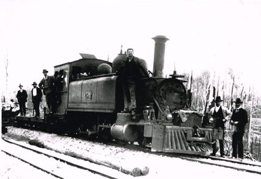 Otway Districts Historical Society
Photograph, Brucker, Beech Forest: Locomotive 5A during construction, c.1902, c.1902
... Railways, to cost $138,000. Construction began in 1900. About 100 men were engaged in laying and ballasting the track while others, not included in the 100, formed the earthworks, culverts and bridges. ...Railways, to cost $138,000. Construction began in 1900. About 100 men were engaged in laying and ballasting the track while others, not included in the 100, formed the earthworks, culverts and bridges. ...In 1898 a recommendation for a railway of 2 ft 6 in gauge was handed down by the Parliamentary Standing Committee on Railways, to cost $138,000. Construction began in 1900. About 100 men were engaged in laying and ballasting the track while others, not included in the 100, formed the earthworks, culverts and bridges. Locomotive operations initially were two 2-6-2 Tank engines of the narrow gauge A class, dubbed "Coffee Pots", and these were used on the work trains between 1900 and 1902. Because of the lengthy periods of waiting time required to unload sleepers and rails or to load ballast meant that a handy replenishment of coal and water supply was necessary. With earthworks specified to the bare minimum landslips in the narrow cuttings were frequent so a repairer was stationed in each length to deal quickly with minor slips until 1904 when the cuttings were widened.B/W. The driver and seven other men on locomotive 5A and its flat cars at Beech Forest during construction of the line in c.1902. beech forest; railways; loco 5a; -
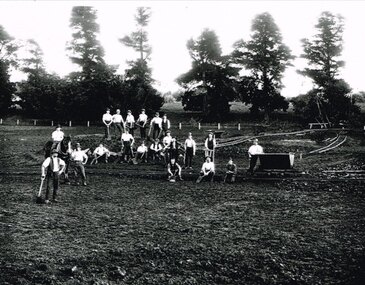 Otway Districts Historical Society
Photograph, Narrow gauge construction camp near Colac, c.1900
... Construction of the Colac-Beech Forest railway line commenced in 1900 and the first activities were the work gangs and their camps. About 100 men were engaged in laying and ballasting the track while others formed the earthworks and the building of culverts and bridges. ...Construction of the Colac-Beech Forest railway line commenced in 1900 and the first activities were the work gangs and their camps. About 100 men were engaged in laying and ballasting the track while others formed the earthworks and the building of culverts and bridges. ...Construction of the Colac-Beech Forest railway line commenced in 1900 and the first activities were the work gangs and their camps. About 100 men were engaged in laying and ballasting the track while others formed the earthworks and the building of culverts and bridges. The first camp was established eight kilometres from Colac, the second 12 km south, and the remainder spaced at similar distances as the work progressed. The camps were served by butchers and bakers from Colac that visited them as many times each week to satisfy the mens' requirements. Many of the men had their families with them. They all lived in tents that consisted of a wooden floor around which the canvas cover was built. A calico partition divided the eating and sleeping quarters, and all cooking was done in camp ovens or at open fires.B/W. 158mm x 203mm. Near Colac, a narrow gauge construction camp comprising 21 workmen, a horse, and two tipping trays.construction camp; railways; colac; -
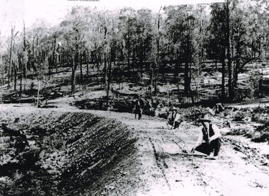 Otway Districts Historical Society
Photograph, Knox Collection, Surveying construction near Barongarook, 1900, 1900
... railway line began in 1900. About 100 men were employed in laying and ballasting the track while others formed the earthworks and the building of culverts and bridges. ...railway line began in 1900. About 100 men were employed in laying and ballasting the track while others formed the earthworks and the building of culverts and bridges. ...In 1898 a recommendation for a railway of 2 ft 6 in gauge was handed down by the Parliamentary Standing Committee on Railways, to cost $138,000. Construction of the Colac-Beech Forest railway line began in 1900. About 100 men were employed in laying and ballasting the track while others formed the earthworks and the building of culverts and bridges. The earthworks of gravel ballast 150 mm deep were formed by horse and scoop or by shovel. Once the bed had been laid surveyors went along to check the layout, particularly all check rail curves and all 100 metre curves which the surveyors in the picture are doing.B/W. Three men surveying the construction of a curved bed on which track will be laid, near Barongarook, Victoria.colac; beech forest; barongarook; railways; -
 Sunshine and District Historical Society Incorporated
Archive - Places of Historic Interest in and around St Albans 2013, Missen Alie Compiler
... Places of Historic Interest in and around St Albans|The ABC Radio mast and transmitter station|The Blue stone Culvert bridge|Sydenham railway station|Robertsons Upper Keilor Homestead|A Sheep Dip|The Overnewton Venue|The Overnewton Gatehouse|Anderson Cottage|the Hume and Hovell Cairn| Keighlo|St Albans Railway Reserve Grasslands|The Anderson Farm House|The St George Fee Serbian Orthodox Church|The Agnes Stevens farmhouse|The Stensons Family Farm|The Errington Reserve Gates|The St Albans Community Youth Centre|St Albans Town Plan|St Albans Uniting Church...Albans Harrsion Places of Historic Interest in and around St Albans|The ABC Radio mast and transmitter station|The Blue stone Culvert bridge|Sydenham railway station|Robertsons Upper Keilor Homestead|A Sheep Dip|The Overnewton Venue|The Overnewton Gatehouse|Anderson Cottage|the Hume and Hovell Cairn| Keighlo|St Albans Railway Reserve Grasslands|The Anderson Farm House|The St George Fee Serbian Orthodox Church|The Agnes Stevens farmhouse|The Stensons Family Farm|The Errington Reserve Gates|The St Albans Community Youth Centre|St Albans Town Plan|St Albans Uniting Church Places of Historic Interest in and around St Albans 2013 Compiled by Alie Missen Archive Places of Historic Interest in and around St Albans 2013 Missen Alie Compiler ...Places of Historic Interest in and around St Albans|The ABC Radio mast and transmitter station|The Blue stone Culvert bridge|Sydenham railway station|Robertsons Upper Keilor Homestead|A Sheep Dip|The Overnewton Venue|The Overnewton Gatehouse|Anderson Cottage|the Hume and Hovell Cairn| Keighlo|St Albans Railway Reserve Grasslands|The Anderson Farm House|The St George Fee Serbian Orthodox Church|The Agnes Stevens farmhouse|The Stensons Family Farm|The Errington Reserve Gates|The St Albans Community Youth Centre|St Albans Town Plan|St Albans Uniting Churchst. albans, harrsion -
 Sunshine and District Historical Society Incorporated
Administrative record - City of Sunshine - Commissioner Mr Alexander Alex George Gillon Collection 1976 - 1982 - Minutes of the ordinary meeting of council held on 27th June 1978, City of Sunshine, 27th June 1978
... Ballarat Road South West Corner Station Road Deer Park Land Use Permit Application Alteration and Addition to Existing Signs to Indicate Operation of Petrol Filling Station as Self-serve Main Road West South East Corner Station Road Land Use Permit Application Sky Sign Lots 8, 9, 10, 11, 13 and Part 12 Highpoint West Shopping Centre Rosamond Road Strata Subdivision 26 Burns Street Strata Subdivision Kodre Street Plan of Transfer and Consolidation Lots 201 & 202 Stevenage Crescent Deer Park Strata Subdivision Burke Street Plan of Subdivision 80 & 82 Rockbank Road Ardeer Albanvale Estate Stages 19 & 20 Contract Supply of Vehicles Heaths Motors Aust Pty Ltd Contract Dempster Park Tennis Courts Contract Supply of Vehicles Heaths Motors Aust Pty Ltd Contract Fencing Sunshine Tip Site Fourth Avenue Private Street Scheme 220kV Transmission Line Keilor Terminal Station to Brooklyn Terminal Station and Proposed Vehicle Wheelwash Sunshine Tip Proposed Culvert at Laverton Creek Boundary Road East of Robinsons Road Ballarat Road / Hampshire Road Junction Proposed Signalisation Load Limit of Roads Tottenham Area Mobil Oil Australia limited Altona to Somerton Pipeline Railway Lots 9 & 66 Anderson Road Sunshine Report of the Acting Building Surveyor Building Over Easements Delegation of Authority Dangerous Building 41 Wright Street Sunshine Report of the Director of Parks & Gardens Weedicide 245T and 24D Bon Thomas Reserve Development Orders of the Day Accounts Submitted for Payment as at 15th June 1978 Statement of Accounts for the Year Ended 30th September 1977 Submitted to be Finally Examined and Settled Confirmation of Loan with the Melbourne & Metropolitan Board of Works Extraordinary Business Report of the City Engineer Sale of Surplus Vehicles Secondhand Four-Wheel Drive Vehicle at Sunshine Tip Land Use Permit Application Commercial Centre and Associated Car Parking Neale Road Land Use Permit Application Alterations and Additions to United Social Cricket Club Rooms Scovell Reserve Scovell Crescent...Ballarat Road South West Corner Station Road Deer Park Land Use Permit Application Alteration and Addition to Existing Signs to Indicate Operation of Petrol Filling Station as Self-serve Main Road West South East Corner Station Road Land Use Permit Application Sky Sign Lots 8, 9, 10, 11, 13 and Part 12 Highpoint West Shopping Centre Rosamond Road Strata Subdivision 26 Burns Street Strata Subdivision Kodre Street Plan of Transfer and Consolidation Lots 201 & 202 Stevenage Crescent Deer Park Strata Subdivision Burke Street Plan of Subdivision 80 & 82 Rockbank Road Ardeer Albanvale Estate Stages 19 & 20 Contract Supply of Vehicles Heaths Motors Aust Pty Ltd Contract Dempster Park Tennis Courts Contract Supply of Vehicles Heaths Motors Aust Pty Ltd Contract Fencing Sunshine Tip Site Fourth Avenue Private Street Scheme 220kV Transmission Line Keilor Terminal Station to Brooklyn Terminal Station and Proposed Vehicle Wheelwash Sunshine Tip Proposed Culvert at Laverton Creek Boundary Road East of Robinsons Road Ballarat Road / Hampshire Road Junction Proposed Signalisation Load Limit of Roads Tottenham Area Mobil Oil Australia limited Altona to Somerton Pipeline Railway Lots 9 & 66 Anderson Road Sunshine Report of the Acting Building Surveyor Building Over Easements Delegation of Authority Dangerous Building 41 Wright Street Sunshine Report of the Director of Parks & Gardens Weedicide 245T and 24D Bon Thomas Reserve Development Orders of the Day Accounts Submitted for Payment as at 15th June 1978 Statement of Accounts for the Year Ended 30th September 1977 Submitted to be Finally Examined and Settled Confirmation of Loan with the Melbourne & Metropolitan Board of Works Extraordinary Business Report of the City Engineer Sale of Surplus Vehicles Secondhand Four-Wheel Drive Vehicle at Sunshine Tip Land Use Permit Application Commercial Centre and Associated Car Parking Neale Road Land Use Permit Application Alterations and Additions to United Social Cricket Club Rooms Scovell Reserve Scovell Crescent Foolscap sized document. ...Minutes of the Ordinary Meeting of Council held on 27th June 1978 Report of the Town Clerk's Department Report of the Town Clerk Proposal for Equalisation of Valuations Street Construction Schemes J.H. Wheelahan Pty Ltd Attempt for Settlement Melbourne Tourism Authority Membership by Council Claim for Consultants Fee Proposed Office Building Now Abandoned Financial Statement Year Ended 30th September 1977 and Auditor's Report Disposal of Garbage City Williamstown to Use Their Own Tip Within The City of Williamstown Transfer of Loan Funds not now Required for the Purpose for Which They Were Borrowed Either in Part or in Full Land Transfer from Melbourne & Metropolitan Board to Works for Road Construction Wright Street Bridge Separate Rate Off Street Parking Scheme Report of the Co-Ordinator of Welfare Services Health Insurance Changes Mordialloc Halfway House Sunshine West Community Health Services Report of the Acting Chief Health Inspector Mantoux Testing and B.C.G. Immunisation (Tuberculosis) Environment Protection Authority (Clean Air Matter) Animals By- Law Victorian Railways Tip Site Disused Quarry Hole Bounded by McDonalds Road, Somerville Road and Bunting Road Abattoir Proposal H.W. Greenham & Sons Pty Ltd Lots 7 & 8 Doherty Road Offensive Trades Prosecution Proceedings Sunshine Magistrates Court Report of the Chief By-Laws Officer Road Traffic Act Proposed Prohibited Parking Big Sam Market St. Albans Road St. Albans Prohibited Parking Martin Street Proposed Limited Parking Derrimut Street and Sydney Street Albion Report of the City Librarian Sunshine - Melton Regional Library Service Report of the City Engineer Land Use Permit Application Extractive Industry Lot 2 Somers Street Land Use Permit Application Grazing of Horses Furlong Road next to Proposed Sunshine Hospital Land Use Permit Application Illuminated Sky Sign 242 Hampshire Road Land Use Permit Application Extension to Bulk Meat Warehouse & Sales 159 - 161 Rosamond Road and 3 White Street Land Use Permit Application Alterations and Additions to United Social Cricket Club Rooms Scovell Reserve Scovell Crescent Land Use Permit Extension to T.A.B. Ballarat Road South West Corner Station Road Deer Park Land Use Permit Application Alteration and Addition to Existing Signs to Indicate Operation of Petrol Filling Station as Self-serve Main Road West South East Corner Station Road Land Use Permit Application Sky Sign Lots 8, 9, 10, 11, 13 and Part 12 Highpoint West Shopping Centre Rosamond Road Strata Subdivision 26 Burns Street Strata Subdivision Kodre Street Plan of Transfer and Consolidation Lots 201 & 202 Stevenage Crescent Deer Park Strata Subdivision Burke Street Plan of Subdivision 80 & 82 Rockbank Road Ardeer Albanvale Estate Stages 19 & 20 Contract Supply of Vehicles Heaths Motors Aust Pty Ltd Contract Dempster Park Tennis Courts Contract Supply of Vehicles Heaths Motors Aust Pty Ltd Contract Fencing Sunshine Tip Site Fourth Avenue Private Street Scheme 220kV Transmission Line Keilor Terminal Station to Brooklyn Terminal Station and Proposed Vehicle Wheelwash Sunshine Tip Proposed Culvert at Laverton Creek Boundary Road East of Robinsons Road Ballarat Road / Hampshire Road Junction Proposed Signalisation Load Limit of Roads Tottenham Area Mobil Oil Australia limited Altona to Somerton Pipeline Railway Lots 9 & 66 Anderson Road Sunshine Report of the Acting Building Surveyor Building Over Easements Delegation of Authority Dangerous Building 41 Wright Street Sunshine Report of the Director of Parks & Gardens Weedicide 245T and 24D Bon Thomas Reserve Development Orders of the Day Accounts Submitted for Payment as at 15th June 1978 Statement of Accounts for the Year Ended 30th September 1977 Submitted to be Finally Examined and Settled Confirmation of Loan with the Melbourne & Metropolitan Board of Works Extraordinary Business Report of the City Engineer Sale of Surplus Vehicles Secondhand Four-Wheel Drive Vehicle at Sunshine Tip Land Use Permit Application Commercial Centre and Associated Car Parking Neale Road Land Use Permit Application Alterations and Additions to United Social Cricket Club Rooms Scovell Reserve Scovell Crescent city of sunshine, alexander "alex" george gillon, sunshine tip, wright street, sunshine, wright street bridge, victorian railways tip, mcdonalds road, somerville road, bunting road, brooklyn, doherty road, deer park, big sam market, st. albans road, st. albans, martin street, derrimut street, sydney street, albion, somers street, sunshine north, furlong road, hampshire road, rosamond road, white street, maribyrnong, united social cricket club, scovell reserve, scovell crescent, maidstone, station road, ballarat road, main road west, highpoint west shopping centre, kodre street, stevenage crescent, burke street, braybrook, rockbank road, ardeer, albanvale, dempster park, burns street, phoenix street, fourth avenue, keilor terminal station, brooklyn terminal station, laverton creek, boundary road, robinsons road, anderson road, bon thomas reserve, quinn street, neale road -
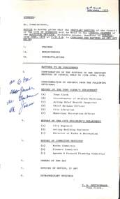 Sunshine and District Historical Society Incorporated
Administrative record - City of Sunshine - Commissioner Mr Alexander "Alex" George Gillon Collection 1976 - 1982 - Notice of Ordinary Meeting of The Council of The City of Sunshine 27th June 1978, City of Sunshine, 21st June 1978
... Ballarat Road South West Corner Station Road Deer Park Land Use Permit Application Alteration and Addition to Existing Signs to Indicate Operation of Petrol Filling Station as Self-serve Main Road West South East Corner Station Road Land Use Permit Application Sky Sign Lots 8, 9, 10, 11, 13 and Part 12 Highpoint West Shopping Centre Rosamond Road Strata Subdivision 26 Burns Street Strata Subdivision Kodre Street Plan of Transfer and Consolidation Lots 201 & 202 Stevenage Crescent Deer Park Strata Subdivision Burke Street Plan of Subdivision 80 & 82 Rockbank Road Ardeer Albanvale Estate Stages 19 & 20 Contract Supply of Vehicles Heaths Motors Aust Pty Ltd Contract Dempster Park Tennis Courts Contract Supply of Vehicles Heaths Motors Aust Pty Ltd Contract Fencing Sunshine Tip Site Fourth Avenue Private Street Scheme 220kV Transmission Line Keilor Terminal Station to Brooklyn Terminal Station and Proposed Vehicle Wheelwash Sunshine Tip Proposed Culvert at Laverton Creek Boundary Road East of Robinsons Road Ballarat Road / Hampshire Road Junction Proposed Signalisation Load Limit of Roads Tottenham Area Mobil Oil Australia limited Altona to Somerton Pipeline Railway Lots 9 & 66 Anderson Road Sunshine Report of the Acting Building Surveyor Building Over Easements Delegation of Authority Dangerous Building 41 Wright Street Sunshine Report of the Director of Parks & Gardens Weedicide 245T and 24D Bon Thomas Reserve Development Orders of the Day Accounts Submitted for Payment as at 15th June 1978 Statement of Accounts for the Year Ended 30th September 1977 Submitted to be Finally Examined and Settled Confirmation of Loan with the Melbourne & Metropolitan Board of Works...Ballarat Road South West Corner Station Road Deer Park Land Use Permit Application Alteration and Addition to Existing Signs to Indicate Operation of Petrol Filling Station as Self-serve Main Road West South East Corner Station Road Land Use Permit Application Sky Sign Lots 8, 9, 10, 11, 13 and Part 12 Highpoint West Shopping Centre Rosamond Road Strata Subdivision 26 Burns Street Strata Subdivision Kodre Street Plan of Transfer and Consolidation Lots 201 & 202 Stevenage Crescent Deer Park Strata Subdivision Burke Street Plan of Subdivision 80 & 82 Rockbank Road Ardeer Albanvale Estate Stages 19 & 20 Contract Supply of Vehicles Heaths Motors Aust Pty Ltd Contract Dempster Park Tennis Courts Contract Supply of Vehicles Heaths Motors Aust Pty Ltd Contract Fencing Sunshine Tip Site Fourth Avenue Private Street Scheme 220kV Transmission Line Keilor Terminal Station to Brooklyn Terminal Station and Proposed Vehicle Wheelwash Sunshine Tip Proposed Culvert at Laverton Creek Boundary Road East of Robinsons Road Ballarat Road / Hampshire Road Junction Proposed Signalisation Load Limit of Roads Tottenham Area Mobil Oil Australia limited Altona to Somerton Pipeline Railway Lots 9 & 66 Anderson Road Sunshine Report of the Acting Building Surveyor Building Over Easements Delegation of Authority Dangerous Building 41 Wright Street Sunshine Report of the Director of Parks & Gardens Weedicide 245T and 24D Bon Thomas Reserve Development Orders of the Day Accounts Submitted for Payment as at 15th June 1978 Statement of Accounts for the Year Ended 30th September 1977 Submitted to be Finally Examined and Settled Confirmation of Loan with the Melbourne & Metropolitan Board of Works Foolscap sized document. ...Notice of Ordinary Meeting of The Council of The City of Sunshine 27th June 1978 Report of the Town Clerk's Department Report of the Town Clerk Proposal for Equalisation of Valuations Street Construction Schemes J.H. Wheelahan Pty Ltd Attempt for Settlement Melbourne Tourism Authority Membership by Council Claim for Consultants Fee Proposed Office Building Now Abandoned Financial Statement Year Ended 30th September 1977 and Auditor's Report Disposal of Garbage City Williamstown to Use Their Own Tip Within The City of Williamstown Transfer of Loan Funds not now Required for the Purpose for Which They Were Borrowed Either in Part or in Full Land Transfer from Melbourne & Metropolitan Board to Works for Road Construction Wright Street Bridge Separate Rate Off Street Parking Scheme Report of the Co-Ordinator of Welfare Services Health Insurance Changes Mordialloc Halfway House Sunshine West Community Health Services Report of the Acting Chief Health Inspector Mantoux Testing and B.C.G. Immunisation (Tuberculosis) Environment Protection Authority (Clean Air Matter) Animals By- Law Victorian Railways Tip Site Disused Quarry Hole Bounded by McDonalds Road, Somerville Road and Bunting Road Abattoir Proposal H.W. Greenham & Sons Pty Ltd Lots 7 & 8 Doherty Road Offensive Trades Prosecution Proceedings Sunshine Magistrates Court Report of the Chief By-Laws Officer Road Traffic Act Proposed Prohibited Parking Big Sam Market St. Albans Road St. Albans Prohibited Parking Martin Street Proposed Limited Parking Derrimut Street and Sydney Street Albion Report of the City Librarian Sunshine - Melton Regional Library Service Report of the City Engineer Land Use Permit Application Extractive Industry Lot 2 Somers Street Land Use Permit Application Grazing of Horses Furlong Road next to Proposed Sunshine Hospital Land Use Permit Application Illuminated Sky Sign 242 Hampshire Road Land Use Permit Application Extension to Bulk Meat Warehouse & Sales 159 - 161 Rosamond Road and 3 White Street Land Use Permit Application Alterations and Additions to United Social Cricket Club Rooms Scovell Reserve Scovell Crescent Land Use Permit Extension to T.A.B. Ballarat Road South West Corner Station Road Deer Park Land Use Permit Application Alteration and Addition to Existing Signs to Indicate Operation of Petrol Filling Station as Self-serve Main Road West South East Corner Station Road Land Use Permit Application Sky Sign Lots 8, 9, 10, 11, 13 and Part 12 Highpoint West Shopping Centre Rosamond Road Strata Subdivision 26 Burns Street Strata Subdivision Kodre Street Plan of Transfer and Consolidation Lots 201 & 202 Stevenage Crescent Deer Park Strata Subdivision Burke Street Plan of Subdivision 80 & 82 Rockbank Road Ardeer Albanvale Estate Stages 19 & 20 Contract Supply of Vehicles Heaths Motors Aust Pty Ltd Contract Dempster Park Tennis Courts Contract Supply of Vehicles Heaths Motors Aust Pty Ltd Contract Fencing Sunshine Tip Site Fourth Avenue Private Street Scheme 220kV Transmission Line Keilor Terminal Station to Brooklyn Terminal Station and Proposed Vehicle Wheelwash Sunshine Tip Proposed Culvert at Laverton Creek Boundary Road East of Robinsons Road Ballarat Road / Hampshire Road Junction Proposed Signalisation Load Limit of Roads Tottenham Area Mobil Oil Australia limited Altona to Somerton Pipeline Railway Lots 9 & 66 Anderson Road Sunshine Report of the Acting Building Surveyor Building Over Easements Delegation of Authority Dangerous Building 41 Wright Street Sunshine Report of the Director of Parks & Gardens Weedicide 245T and 24D Bon Thomas Reserve Development Orders of the Day Accounts Submitted for Payment as at 15th June 1978 Statement of Accounts for the Year Ended 30th September 1977 Submitted to be Finally Examined and Settled Confirmation of Loan with the Melbourne & Metropolitan Board of Works city of sunshine, alexander "alex" george gillon, wright street bridge, wright street, sunshine, victorian railways tip site, somerville road, mcdonalds road, doherty road, big sam market, st. albans road, st. albans, martin street, derrimut street, sydney street, albion, furlong road, hampshire road, rosamond road, white street, maribyrnong, united social cricket club, scovell reserve, scovell crescent, maidstone, ballarat road, station road, deer park, main road west, highpoint west shopping centre, burns street, stevenage crescent, burke street, braybrook, rockbank road, ardeer, dempster park, phoenix street, sunshine tip, fourth avenue, laverton creek, boundary road, robinsons road, anderson road, bon thomas reserve, quinn street, somers street
