Showing 104 items matching "recreational reserve"
-
 City of Moorabbin Historical Society (Operating the Box Cottage Museum)
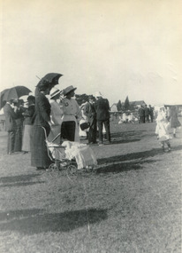
Photograph (collection) - Bentleigh Recreational Reserve, Gathering of East Bentleigh Residents, c 1915
... Bentleigh Recreational Reserve......bentleigh recreational reserve...The dedication of the pioneers of the City of Moorabbin. bentleigh city of moorabbin bentleigh recreational reserve william burgess fundraising volunteers sport Black and white Photo of residents of Bentleigh gathering on Bentleigh Recreation Reserve Gathering of East Bentleigh Residents Photograph Bentleigh Recreational Reserve ...bentleigh, city of moorabbin, bentleigh recreational reserve, william burgess, fundraising, volunteers, sportbentleigh, city of moorabbin, bentleigh recreational reserve, william burgess, fundraising, volunteers, sport -
 University of Melbourne, Burnley Campus Archives
Plan, City of Keilor, Delahey Recreational Reserve, Tennis Complex, Goldsmith Ave, 1994
... City of Keilor, Delahey Recreational Reserve, Tennis Complex, Goldsmith Ave.......delahey recreational reserve...City of Keilor, Delahey Recreational Reserve, Tennis Complex, Goldsmith Ave. ...(1) Planting Plan, coloured, dated 19.08.1994, Sheet 3 of 3. by J.Coghill. Scale 1:100. (2) Sheet 2 of 3.keilor, delahey recreational reserve, , j. coghill, planting plan -
 Inverloch Historical Society
004363 - Photographs - 2018 - Cypress Pine trees at Inverloch Recreational Reserve showing the space before and after the trees were removed - from John Hutchinson
... 004363 - Photographs - 2018 - Cypress Pine trees at Inverloch Recreational Reserve showing the space before and after the trees were removed - from John Hutchinson...Inverloch gippsland 004363 - Photographs - 2018 - Cypress Pine trees at Inverloch Recreational Reserve showing the space before and after the trees were removed - from John Hutchinson ... -
 Ballarat Tramway Museum
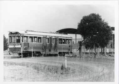
Photograph - Photograph - black and white, Tram 39 being returned to Ballarat from Lismore, May 1976
... ...recreational reserve...When the Ballarat Tramways closed in 1971, it was sold to Lismore Lions Club and displayed in a recreational reserve. Ballarat Tramway Museum purchased the tram in 1976 and converted it into a museum display and souvenir centre. ...When the Ballarat Tramways closed in 1971, it was sold to Lismore Lions Club and displayed in a recreational reserve. Ballarat Tramway Museum purchased the tram in 1976 and converted it into a museum display and souvenir centre. ...Tram 39 was built in 1914 for the Prahran and Malvern Tramways Trust. In 1951 it was sold to the State Electricity Commission, Ballarat, and renumbered 39. When the Ballarat Tramways closed in 1971, it was sold to Lismore Lions Club and displayed in a recreational reserve. Ballarat Tramway Museum purchased the tram in 1976 and converted it into a museum display and souvenir centre. This was used until the new Museum building was opened in 2022. These photos show the process of loading the tram onto a truck in Lismore and bringing it back to Ballarat. The date of this was 9 May 1976. All photographs were taken by the donor, Campbell Duncan. Each photograph has information written on the back. .1 Lismore, 8/5/76 .2 Lismore, 8/5/76 .3 39 waits to be jacked down - truck ready to depart.9/5/76 .4 Truck has pulled out after 39 jacked up from it. Truck faces back down the driveway. 9/5/76. .5 Lismore. 9/5/76 .6 Lismore. 9/5/76 .7 Lismore. 9/5/76 .8 Lismore. 9/5/76 .9 Mair Street Ballarat East 9/5/76 .10 Mair Street Ballarat East 9/5/76 .11 Victoria Street Ballarat East 9/5/76 .12 Victoria Street Ballarat East 9/5/76 .13 Ballarat East, Victoria Street 9/5/76 .14 Victoria Street Ballarat East 9/5/76 .15 Victoria Street. Truck about to back down driveway 9/5/76. (this photo was used in Ballarat Courier of 15/5/76) See photo 10212. .16 Truck pulling out from under 39. 39's storage shed, Victoria Street Ballarat East 9/5/76. Sixteen black and white photographs taken of Tram 39 being transported from Lismore to Ballarat.Photo information on back of each phototram 39, 1914, prahran and malvern tramways trust, sec ballarat, 1951, lismore lions club, 1971, recreational reserve, ballarat tramway museum, 1976, museum display, souvenir centre, museum opened 2022, mair stree, victoria street, ballarat east, may 1976 photos, photographer, campbell duncan -
Marysville & District Historical Society
THE TRIANGLE NEWS-VOL 41 NO 19-MAY 23 2014
... ...buxton recreational reserve...marysville victoria australia marysville main street goes pink for breast cancer support breast cancer network australia marysville mini-field of women triangle new contact details what's on when in may 2014 seasonal influenza vaccine available the committee of management of the gallipoli park precinct marysville community market creative triangle marysville sub-branch rsl portable skate ramp at buxton reserve church notices marysville golf report emotions anonymous international intrepid triangle bushwalkers mayor's chair advertisements councillor comment buxton recreational reserve marysville and triangle community men's shed marsyville saddletramps payment of rate instalment residential and rural real estate marysville triangle real estate marysville water treatment plant upgrade underway requiem mass elaine postlethwaite r.i.p. dianne mcnamara marysville triangle youth christ church marysville blumes fashion winter collection council welcomes permit exemptions from bushfire rebuilding efforts cleaner needed for marysville villains alexandra clearing sale marysville midweek netball tenders marysville preschool centre long day care & kindergarten el kanah marysville eat in eat out menu council plans for future financial stability depression recovery program emergence from surviving to thriving lake mountain opening weekend buxton hall trivia night good governance in practice training and compliance systems & solutions cfa mountains mayhem THE TRIANGLE NEWS-VOL 41 NO 19-MAY 23 2014 ...marysville, victoria, australia, marysville main street goes pink for breast cancer support, breast cancer network australia, marysville mini-field of women, triangle new contact details, what's on when in may, 2014 seasonal influenza vaccine available, the committee of management of the gallipoli park precinct, marysville community market, creative triangle, marysville sub-branch rsl, portable skate ramp at buxton reserve, church notices, marysville golf report, emotions anonymous international, intrepid triangle bushwalkers, mayor's chair, advertisements, councillor comment, buxton recreational reserve, marysville and triangle community men's shed, marsyville saddletramps, payment of rate instalment, residential and rural real estate, marysville triangle real estate, marysville water treatment plant upgrade underway, requiem mass elaine postlethwaite, r.i.p. dianne mcnamara, marysville triangle youth, christ church marysville, blumes fashion winter collection, council welcomes permit exemptions from bushfire rebuilding efforts, cleaner needed for marysville villains, alexandra clearing sale, marysville midweek netball, tenders, marysville preschool centre, long day care & kindergarten, el kanah marysville, eat in eat out menu, council plans for future financial stability, depression recovery program, emergence from surviving to thriving, lake mountain opening weekend, buxton hall trivia night, good governance in practice, training and compliance systems & solutions, cfa, mountains mayhem -
Marysville & District Historical Society
THE TRIANGLE NEWS-VOL 40 NO 19-MAY 24 2013
... ...buxton recreational reserve...marysville victoria australia $28 million vibe hotel marsyville breaks ground deputy premier and minister for regional & rural development peter ryan what's on when in may and june buxton recreational reserve working bee intrepid triangle bushwalkers the committee of management of the gallipoli park precinct marysville community market creative triangle fire services levy now part of rates notices church notices triangle community dinner el kanah village biggest morning tea a success vale brian moore murrindindi shire council payment of rate installment position vacant mayor's chair marysville primary school mother's day raffle advertisements buxton fire brigade anna's mobile patchwork quilt shop open capital works program supports existing infrastructure villains storm home to first ever away victory staff wanted black spur inn greenlands guesthouse open by lachlan fraser building our future draft council plan released for comment emotions anonymous international buxton hotel real estate marysville golf report snowgum hillary challenge comes to marysville last quarter assault gets villains home free mulch loading triangle community dance group marysville villains sponsors and members lunch randy the puppet is back for lunch draft council plan and budget have your say melbourne international comedy festival marysville & district lions club road maintenance and construction works free information session council delivers conservative draft budget yarra valley div 1 game in marysville a success THE TRIANGLE NEWS-VOL 40 NO 19-MAY 24 2013 ...marysville, victoria, australia, $28 million vibe hotel marsyville breaks ground, deputy premier and minister for regional & rural development, peter ryan, what's on when in may and june, buxton recreational reserve, working bee, intrepid triangle bushwalkers, the committee of management of the gallipoli park precinct, marysville community market, creative triangle, fire services levy now part of rates notices, church notices, triangle community dinner, el kanah village, biggest morning tea a success, vale brian moore, murrindindi shire council, payment of rate installment, position vacant, mayor's chair, marysville primary school mother's day raffle, advertisements, buxton fire brigade, anna's mobile patchwork quilt shop open, capital works program supports existing infrastructure, villains storm home to first ever away victory, staff wanted black spur inn, greenlands guesthouse open by lachlan fraser, building our future draft council plan released for comment, emotions anonymous international, buxton hotel, real estate, marysville golf report, snowgum hillary challenge comes to marysville, last quarter assault gets villains home, free mulch loading, triangle community dance group, marysville villains sponsors and members lunch, randy the puppet is back for lunch, draft council plan and budget have your say, melbourne international comedy festival, marysville & district lions club, road maintenance and construction works free information session, council delivers conservative draft budget, yarra valley div 1 game in marysville a success -
Marysville & District Historical Society
THE TRIANGLE NEWS-VOL 41 NO 32-AUGUST 22 2014
... ...buxton recreational reserve committee agm...marysville victoria australia community projects to deliver for taggerty little river reserve the project reference group victorian bushfire appeal fund murrindindi shire council what's on when in august the committee of management of the gallipoli park precinct marysville community market creative triangle gallipoli park precinct agm triangle community dinner el kanah village church notices marysville golf report gallipoli park mayor's chair by cr margaret rae councillor comment cr john kennedy cheviot ward advertisments concert bus the country touch bus residential & rural real estate marysville triangle real estate murrindindi shire residents urged to detox their homes marysville community golf & bowls club marysville villains best & fairest dinner narbethong community hall dinner & show intrepid triangle bushwalkers retail opportunities marysville preschool centre long day care & kindergarten council concerned about unlawful firewood collection alexandra pastoral & agricultural assocn show secretary position fooball & netball live at gallipoli park buxton recreational reserve committee agm craft market & indoor garage sale buxton hall marysville & district cricket club ugln practical advice for landholders with properties trevor harrow oval clean up THE TRIANGLE NEWS-VOL 41 NO 32-AUGUST 22 2014 ...marysville, victoria, australia, community projects to deliver for taggerty, little river reserve, the project reference group, victorian bushfire appeal fund, murrindindi shire council, what's on when in august, the committee of management of the gallipoli park precinct, marysville community market, creative triangle, gallipoli park precinct agm, triangle community dinner, el kanah village, church notices, marysville golf report, gallipoli park, mayor's chair by cr margaret rae, councillor comment cr john kennedy cheviot ward, advertisments, concert bus, the country touch bus, residential & rural real estate, marysville triangle real estate, murrindindi shire residents urged to detox their homes, marysville community golf & bowls club, marysville villains best & fairest dinner, narbethong community hall dinner & show, intrepid triangle bushwalkers, retail opportunities, marysville preschool centre, long day care & kindergarten, council concerned about unlawful firewood collection, alexandra pastoral & agricultural assocn, show secretary position, fooball & netball live at gallipoli park, buxton recreational reserve committee agm, craft market & indoor garage sale, buxton hall, marysville & district cricket club, ugln, practical advice for landholders with properties, trevor harrow oval clean up -
 Whitehorse Historical Society Inc.
Photograph, Slaters Reserve - Parkland, 1/08/2009 12:00:00 AM
... Coloured Photograph of the recreational area of Slaters Reserve ...Whitehorse Historical Society Inc. 2-10 Deep Creek Road Mitcham melbourne See the following relating Slater & the Reserve ND2000, 3558, 4396, 5141 & 5824. slaters reserve stadium basketball Coloured Photograph of the recreational area of Slaters Reserve Slaters Reserve - Parkland Photograph Photograph ...See the following relating Slater & the Reserve ND2000, 3558, 4396, 5141 & 5824.Coloured Photograph of the recreational area of Slaters Reserve slaters reserve, stadium, basketball -
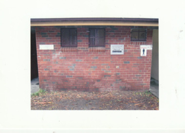 Port Melbourne Historical & Preservation Society
Photograph - Lagoon Reserve Pavilion, Alice TURNBULL, 2009
... Built Environment - Recreational Facilities...Lagoon Reserve...As part of the upgrade of the Lagoon Reserve, this pavilion was demolished and replaced by a new structure in 2026. Built Environment - Recreational Facilities Lagoon Reserve Pavilion Photos taken for rainwater tank near Lagoon Reserve Pavilion 2009 Coloured photograph of toilet entrances at the Lagoon Reserve Pavilion, Port Melbourne. ...As part of the upgrade of the Lagoon Reserve, this pavilion was demolished and replaced by a new structure in 2026.Coloured photograph of toilet entrances at the Lagoon Reserve Pavilion, Port Melbourne.Photos taken for rainwater tank near Lagoon Reserve Pavilion 2009built environment - recreational facilities, lagoon reserve pavilion -
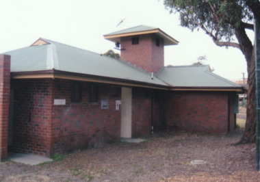 Port Melbourne Historical & Preservation Society
Photograph - Lagoon Reserve pavilion, Alice TURNBULL, 2009
... Built Environment - Recreational Facilities...Lagoon Reserve...As part of the upgrade of the Lagoon Reserve, this pavilion was demolished and replaced by a new structure in 2026. Built Environment - Recreational Facilities Lagoon Reserve Pavilion Coloured photograph of Lagoon Reserve pavilion, Port Melbourne. ...As part of the upgrade of the Lagoon Reserve, this pavilion was demolished and replaced by a new structure in 2026.Coloured photograph of Lagoon Reserve pavilion, Port Melbourne.built environment - recreational facilities, lagoon reserve pavilion -
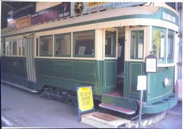 Ballarat Tramway Museum
Photograph - Photograph - coloured, Tram 39 - Maximum Traction truck bogie, drop end and centre combination. Museum Display inside
... Lismore Lions Club bought it in 1971 and displayed it in a recreational reserve until the Ballarat Museum purchased it in 1976. the Museum converted it into a museum display and souvenir centre at the depot until the new Museum building was opened in 2022....Lismore Lions Club bought it in 1971 and displayed it in a recreational reserve until the Ballarat Museum purchased it in 1976. the Museum converted it into a museum display and souvenir centre at the depot until the new Museum building was opened in 2022. tram 39 1914 prahran and malvern tramways trust tram 42 state electricity commission 1951 lismore lions club ballarat tramway museum 1976 museum and souvenir shop new museum 2022 Tram green and cream number 39 in gold on ends and sides. ...The tram was built in 1914 for the Prahran and Malvern Tramways Trust and had the number 42. It was sold to the State Electricity Commission in 1951 and renumbered 39. Lismore Lions Club bought it in 1971 and displayed it in a recreational reserve until the Ballarat Museum purchased it in 1976. the Museum converted it into a museum display and souvenir centre at the depot until the new Museum building was opened in 2022.Large coloured photograph of a tram, laminated. Sign outside - Museum Display EntryTram green and cream number 39 in gold on ends and sides. City Oval in destination window. Advertising boards on top of tram.tram 39, 1914, prahran and malvern tramways trust, tram 42, state electricity commission, 1951, lismore lions club, ballarat tramway museum, 1976, museum and souvenir shop, new museum 2022 -
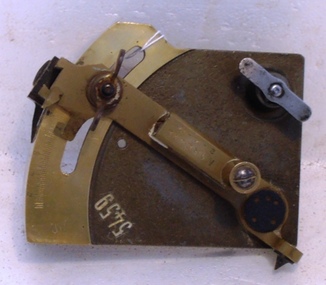 8th/13th Victorian Mounted Rifles Regimental Collection
Weapon - Gun sight, 1916 circa
... After the war a recreational reserve in Albury NSW was named Noreuil Park after the French village near where the action occurred....After the war a recreational reserve in Albury NSW was named Noreuil Park after the French village near where the action occurred. ...This gun sight was brought home from WWI (1914-1918) by members of the 13th Battery 5th Field Artillery Brigade (Albury Battery) as a souvenir of its action in the first battle of Bullecourt April 1917. On one occasion during the battle the Battery was surrounded by a German counter attack. They dragged their guns out of the gun pits and continued firing to the flanks and rear and supported the Australian counter penetration attack which restored the situation. After the war a recreational reserve in Albury NSW was named Noreuil Park after the French village near where the action occurred.A rare object with significant connection to Albury NSW and its citizen soldiers who served with the AIF in WWI (1914-1918). The engraving gives it close association with the recreational park in Albury named after the French village of Noreuil and honouring the soldiers who fought there with great courage. Range drum portion of the sighting mechanism from an 18 Pounder field gun made of brass and other metals. The object is engraved with the word NOREUIL and the date 2.4.17.Serial No 5459; and NOREUIL 2.4.17gun sight, noreuil, albury, 13th battery -
City of Kingston
Photograph - Colour, Circa 1993
... Edithvale Recreational reserve, the velodrome and Edithvale Public Golf Course are prominent. ...Edithvale Recreational reserve, the velodrome and Edithvale Public Golf Course are prominent. ...Edithvale is a suburb in the City of Kingston. It is located between Aspendale and Chelsea on the Port Phillip Bay and built within remnant areas of the Carrum Carrum swamp. The foreshore precinct comprises a wide sandy beach, with low sand dunes and numerous historic boat sheds. The suburb consists of older style dwellings and former holiday houses, combined with mid-century housing and newer homes. The large blocks are increasingly subdivided and the existing dwellings demolished to accommodate units and townhouses, thus changing the landscape of the area and reducing the tree canopy.The beachside suburb of Edithvale was previously part of the extensive Carrum Carrum Swamp. The area was once a source of fish and eels for the Mayone-Bulluk clan of the Bunurong people. Over time the area was drained and predominantly devoted to dairy farming and holiday houses. The farms were gradually sold and subdivided with a large number of homes built after World War II and in the 1960s. Edithvale is mainly residential with a shopping strip along Nepean Highway but little significant industry was ever established in the area apart from a plaster works and confectionary factory, both now closed.Aerial colour photograph of Edithvale as viewed from Alexandra Avenue in the north to Ella Grove Chelsea/Edithvale in the south. The area is built-up with residential housing and facilities including Edithvale Primary School, numerous churches and the Edithvale Railway station. Large sections depict the remnant Carrum Carrum swamp. Edithvale Common and the former "Duck Inn" (Melbourne Water/Friends of Edithvale Seaford Wetlands) can be seen. Edithvale Recreational reserve, the velodrome and Edithvale Public Golf Course are prominent. The image shows vacant land in the area now known as Aspendale Gardens and the newer residential section of Chelsea Heights is not developed. A bike path has been established to cover the secondary drain. The Golf Links Court residential development located off Hughes Avenue is a large vacant block.Yellow circular adhesive sticker on plastic Black ink (marker): * (asterisk) Black type on white adhesive sticker: P000108edithvale, aspendale, chelsea, carrum carrum swamp -
City of Kingston
Photograph - Colour, 6 March 1993
... Edithvale Recreational reserve, the valodrome and Edithvale Public Golf Course are prominent. ...Edithvale Recreational reserve, the valodrome and Edithvale Public Golf Course are prominent. ...Edithvale is a suburb in the City of Kingston. It is located between Aspendale and Chelsea on the Port Phillip Bay and built within remnant areas of the Carrum Carrum swamp. The foreshore precinct comprises a wide sandy beach, with low sand dunes and numerous historic boat sheds. The suburb consists of older style dwellings and former holiday houses, combined with mid-century housing and newer homes. The large blocks are increasingly subdivided and the existing dwellings demolished to accommodate units and townhouses, thus changing the landscape of the area and reducing the tree canopy.The beachside suburb of Edithvale was previously part of the extensive Carrum Carrum Swamp. The area was once a source of fish and eels for the Mayone-Bulluk clan of the Bunurong people. Over time the area was drained and predominantly devoted to dairy farming and holiday houses. The farms were gradually sold and subdivided with a large number of homes built after World War II and in the 1960s. Edithvale is mainly residential with a shopping strip along Nepean Highway but little significant industry was ever established in the area apart from a plaster works and confectionary factory, both now closed.Laminated aerial colour photograph of Edithvale as viewed from Alexandra Avenue in the north to Ella Grove Chelsea/Edithvale in the south. regents Park Aspendale can be seen in the top left. The area is built-up with residential housing and facilities including Edithvale Primary School, numerous churches and the Edithvale Railway station. Large sections depict the remnant Carrum Carrum swamp. Edithvale Common and the former "Duck Inn" (Melbourne Water/Friends of Edithvale Seaford Wetlands) can be seen. Edithvale Recreational reserve, the valodrome and Edithvale Public Golf Course are prominent. The image shows vacant land in the area now known as Aspendale Gardens and the newer residential section of Chelsea Heights is not developed. A bike path has been established to cover the secondary drain. The Golf Links Court residential development located off Hughes Avenue is a large vacant block.Black type on white adhesive label: 6-3-93 Black type on white adhesive label: 25/9211, 6/3/93, 11.20 am Black type on white adhesive label: 9211 Yellow circular adhesive sticker Black pencil: 9211 6-3-93 arrow pointing Nedthvale, carrum carrum swamp, aspendale, chelsea -
 Bayside Gallery - Bayside City Council Art & Heritage Collection
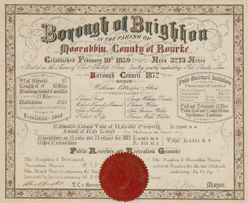
Certificate - Illuminated certificate, Brighton Municipal Certificate, 1872
... Gives details of the municipality in 1872 including list of councillors, number of streets, public buildings and institutions, reserves and recreational grounds, population, value of rateable property and and expenditure. ...Bayside Gallery - Bayside City Council Art & Heritage Collection Corner Wilson and Carpenter Streets Brighton melbourne bayside city council borough of brighton illuminated certificate population rates public buildings WP Allen Mayor Town Clerk Surveyor Councillors Council borough county of Bourke Gives details of the municipality in 1872 including list of councillors, number of streets, public buildings and institutions, reserves and recreational grounds, population, value of rateable property and and expenditure. ...bayside city council, borough of brighton, illuminated, certificate, population, rates, public buildings, wp allen, mayor, town clerk, surveyor, councillors, council, borough, county of bourke -
 Bayside Gallery - Bayside City Council Art & Heritage Collection
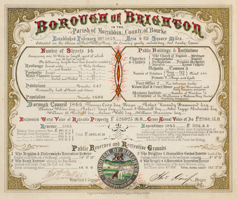
Certificate - Illuminated certificate, Hamel & Fergsuon, Brighton Municipal Certificate, 1866
... Gives details of the Borough of Brighton in 1866 including list of councillors, number of streets, public buildings and institutions, reserves and recreational grounds, population, value of rateable property, revenue and expenditure. ...Bayside Gallery - Bayside City Council Art & Heritage Collection Corner Wilson and Carpenter Streets Brighton melbourne bayside city council borough of brighton illuminated certificate population rates public buildings mayor town clerk surveyor councillors council borough county of bourke thomas crisp cr t. crisp census Parish of Moorabbin Hamel & Ferguson coat of arms Gives details of the Borough of Brighton in 1866 including list of councillors, number of streets, public buildings and institutions, reserves and recreational grounds, population, value of rateable property, revenue and expenditure. ...bayside city council, borough of brighton, illuminated, certificate, population, rates, public buildings, mayor, town clerk, surveyor, councillors, council, borough, county of bourke, thomas crisp, cr t. crisp, census, parish of moorabbin, hamel & ferguson, coat of arms -
 City of Moorabbin Historical Society (Operating the Box Cottage Museum)
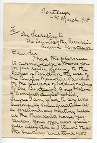
Letter - The Bentleigh Soldier's Welcome & Comforts League 1918
... William and Lucy lived in Jasper Road opposite the recreational reserve. William was a poultry breeder and a local accountant, auditor, real estate, insurance and general commission agent....William and Lucy lived in Jasper Road opposite the recreational reserve. William was a poultry breeder and a local accountant, auditor, real estate, insurance and general commission agent. ...A letter sent to the Secretary of the trustees of the Bentleigh Recreation Reserve, from Lucy Wood, for the Bentleigh Soldier's Comfort League requesting the use of the Burgess Pavilion for the Leagues meetings. The Bentleigh Soldier’s Comforts League is but one example of many other organisations that made use of the pavilion. After the League’s inaugural meeting a letter was sent to the Trustees of the Recreation Preserve Bentleigh requesting the use of the pavilion to hold their meetings. The objects of the Bentleigh Soldier’s Comforts League were: 1. To provide comforts for Bentleigh boys on active duty 2. To ensure a suitable public welcome upon their return 3. To visit the sick and wounded ones at the Military hospitals A committee of local ladies formed a committee, An amount of 2s was allotted to each worker who endeavored by personal effort to increase that sum. A Gymkhana, in association with the Equestrienne Club, was held to raise funds to help the return soldiers and to send Xmas boxes to the soldiers on active duty abroad. Lucy Wood (1872 - 1956) was the wife of William Howard Wood (1868 - 1947). William and Lucy lived in Jasper Road opposite the recreational reserve. William was a poultry breeder and a local accountant, auditor, real estate, insurance and general commission agent.The efforts made by the citizens of the Shire of Morrabbin to send comforts to the troups overseas during WWI, and to welcome home the soldiers.A hand written letter wwi, city of moorabbin, lucy wood, burgess pavilion, bentleigh recretional reserve, william burgess, fundraising, xmas boxes, bentleigh soldier’s comforts league, bentleigh, moorabbin -
 City of Kingston
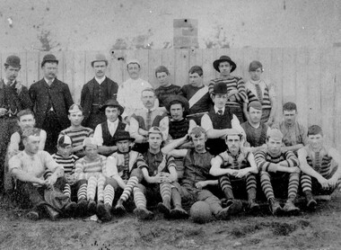
Photograph - Black and white, c. 1908
... That application was received and granted, then developed where Cheltenham Recreational Reserve now stands. The ground was opened in 1909 and the first Cheltenham side entered in the newly formed Federal Football League along with seven other foundation members, Mordialloc, Mentone, Moorabbin, Frankston, Glenhuntly, Elsternwick, and Ellindale. ...That application was received and granted, then developed where Cheltenham Recreational Reserve now stands. The ground was opened in 1909 and the first Cheltenham side entered in the newly formed Federal Football League along with seven other foundation members, Mordialloc, Mentone, Moorabbin, Frankston, Glenhuntly, Elsternwick, and Ellindale. ...Australian rules football began being played on a regular basis in Cheltenham in 1890. Teams would not only play locally but travel by train fairly long distances, such as to Ballarat, for the day, play a game, turn around and come home. The Cheltenham home games were played on a paddock on the corner of Park and Charman roads in Cheltenham. In 1907 the Cheltenham progress committee made an application to the board of land works for land in Weatherall Road for recreational service to the public. That application was received and granted, then developed where Cheltenham Recreational Reserve now stands. The ground was opened in 1909 and the first Cheltenham side entered in the newly formed Federal Football League along with seven other foundation members, Mordialloc, Mentone, Moorabbin, Frankston, Glenhuntly, Elsternwick, and Ellindale. The grand final for that year, 1909 was a hard encounter between Cheltenham and Ellindale with Cheltenham coming out victors, thus becoming the inaugural Federal Football League premiers. The Federal Football League (FFL), also known simply as the Federal League, was an Australian rules football competition in the south-eastern suburbs of Melbourne, Victoria. The competition was in existence from 1909 to 1981 and was regarded as one of the strongest metropolitan leagues in Melbourne.Black and white image of the players and officials of the Cheltenham Football Club. Back (left to right) G Puttick, Franklyn (sic), Unkown, Unknown, C Corstorphine, D Arland, Dave Hughes, H Bryant, Centre: T Elliott, S Parsons, F Judd, H Foreman, N Corstorphine, J McCormack, S Chandler, H Orr. Front: H Clayton - no other names recorded. The players are wearing what appears to be a range of club jumpers, with some in street wear. Some players seated in the front row have mud visible on the soles of their shoes, indicating they may have already played a gam. The ball on the ground in front of the group is round.Round red sticker on reverse with handwritten text: X10 Handwritten in blue ink: A11, with a circle around it Handwritten in red ink: 50%sport, football, cheltenham, teams, federal football league -
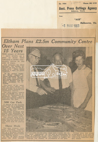 Eltham District Historical Society Inc
Newspaper Clipping, Eltham Plans £2.5m Community Centre Over Next 15 Years, The Age, 6 March 1963 page 7, 1963
... The result of six years' work by shire officers, the plan provides for a business centre, public buildings and recreational reserves. The shire council expects that £2,500,000 will be invested by Government departments, banks, private firms and sporting bodies to implement the plan. 500 Car Park A feature of the business centre will be a quadrangle car park surrounded by shops, and with parking space for 500 cars. ...The result of six years' work by shire officers, the plan provides for a business centre, public buildings and recreational reserves. The shire council expects that £2,500,000 will be invested by Government departments, banks, private firms and sporting bodies to implement the plan. 500 Car Park A feature of the business centre will be a quadrangle car park surrounded by shops, and with parking space for 500 cars. ...Eltham Plans £2.5m Community Centre Over Next 15 Years THE people of Eltham have drawn up a plan to make their township a model community centre in the next 15 years. And yesterday the Chief Secretary (Mr Rylah) inspected the plan at the Eltham shire offices before declaring it open for public inspection In the picture (right) Mr. Rylah (centre) is shown inspecting the new plan with town planner and former councillor, Mr. Howard Bartlett, and the shire president, Cr. C. Pelling. The result of six years' work by shire officers, the plan provides for a business centre, public buildings and recreational reserves. The shire council expects that £2,500,000 will be invested by Government departments, banks, private firms and sporting bodies to implement the plan. 500 Car Park A feature of the business centre will be a quadrangle car park surrounded by shops, and with parking space for 500 cars. The public buildings will include new municipal offices, a public auditorium, a library and meeting rooms. The council plans to realign the course of Diamond Creek near the town to provide extra land for playing fields. Three Ovals The plan proposes three ovals, including improvements to an existing one, as well as a 50-metre Olympic swimming pool, tennis courts and bowling greens. In the 15 years which the shire council hopes to carry out the plan, the shire population of 18,000 is expected to increase two and a half times. Opening the display of maps and a model, Mr. Rylah said he commended the shire council's invitation to the citizens to suggest improvements to the plan. Eltham shire had grown tremendously in the past 20 years, from a sleepy country town to an important shopping centre. Digital file only of copy provided on loanauditorim, bowlong green, charis pelling, eltham community centre, rylah, howard bartlett, car park, library, forward plan -
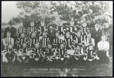 City of Moorabbin Historical Society (Operating the Box Cottage Museum)
Photographs, x 3 Black & White Cheltenham Football Club 1909,1913, 1946, 20thC
... That application was received and granted, then developed where Cheltenham Recreational Reserve now stands. The land in the early days was virgin bush and the response for voluntary help to clear the area was outstanding. ...That application was received and granted, then developed where Cheltenham Recreational Reserve now stands. The land in the early days was virgin bush and the response for voluntary help to clear the area was outstanding. ...Known as the Rosellas, the early Cheltenham Football Club sides began playing on a regular basis in 1890, and would travel long distances by steam train to play country teams, such as Ballarat where they would arrive at their destination, play the match, socialize then return to the station. Opposition players and supporters would give three hearty cheers on their departure. The Cheltenham home games were played on a paddock on the corner of Park and Charman roads in Cheltenham. In 1907 the Cheltenham progress committee made an application to the board of land works for land in Weatherall Road for recreational service to the public. That application was received and granted, then developed where Cheltenham Recreational Reserve now stands. The land in the early days was virgin bush and the response for voluntary help to clear the area was outstanding. Nearly all the market gardeners in the district along with horses, ploughs, axes, shovels completely cleared the area in three weeks. The Moorabbin council then leveled the playing area and erected a post and rail fence around the ground. Pine tree shrubs were then planted on the west side of the ground. The ground was opened in 1909 and the first Cheltenham side entered in the newly formed Federal Football Association along with seven other foundation members, Mordialloc, Mentone, Moorabbin, Frankston, Glenhuntly, Elsternwick, and Ellindale. The grand final for that year, 1909 was a hard encounter between Cheltenham and Ellindale with Cheltenham coming out victors, thus becoming the inaugural Federal Football Association premiers. Cheltenham went onto win five senior premierships in the Federal Football Association by the end of the 1920s, they won the flags in 1909, 1911, 1913, 1922 and 1925, with the late Percy Woff playing in all 5 premiership sides and was captain in 1922. 1928 saw the start of an outstanding career from our oldest living player Tom Connor. Cheltenham continued to win premierships in the 1920’s and 1930’s with juniors taking out the 1929 and 1933 flags, under the guidance of Woff, and that continued in 1934 when Cheltenham took out the 1st XVIII and 2nd XVIII premierships. Cheltenham produced its only Brownlow medallist in Peter Box who played in the late 1940s, before going to Footscray where he became a champion. The 3rd XVIII went through the season undefeated in 1974 winning the premiership, with Trevor Barker a key player before going to St Kilda the following year. The club won three senior premierships under coach Barry White in 1992, 1993 and 1995. ( from CFNC website 2019) Cheltenham Football Club was formed 1890 and succeeded in winning many Premierships as a member of the Federal Football Association, Outstanding players Peter Box Brownlow Medalist 1956 Footscay VFL, , Trevor Barker and Kevin Roberts St Kilda VFL.3x Black & White photographs of the players in the Australian Rules Cheltenham Football Club 1909, 1913 and 1946 extra photo of Peter Box Folio 10 MAV 01059a) CHELTENHAM FOOTBALL CLUB 1909 Cheltenham Football Club 1909. Back row: A Chandler, committee member; R. Robertson, back-pocket; J. Harris, half back flank; J Adams, ruck and forward-pocked; M. J. Monk, club president; L. Woff, back-pocket; W. Adams, ruck and back-pocket; P. Woff, rover and forward-pocket; A Monk, committee member. Middle row: W. Hore, back pocket and ruck; A. Towns, half-forward flank; W. Carson, full back; F. Andrews, captain-half forward flank; H. Butler, centre half back; J. Warburton, centre half-forward; A. Slater, half-back flank; F. Fisher, half-forward flank; C. Sherwood, trainer. Front Row: G Gouldthorpe, wing; H. King, full-forward; W. Johnston, ruck and forward-pocket; P Spears, rover and forward-pocket; F. Bichl, wing; A. Bichl. rover and forward-pocket; F. Butler, centre player. Courtesy, Lionel Seal. ( from CFC website 2019) b) CHELTENHAM 1913 PREMIERS c) CHELTENHAM -1946 / Back row - J. Fisher, G.Corrigan, N.Hocking, F.Virtue, R.Craven, L.Baker, M.Blundell / 2nd Row - J.Phillips, T.Connor, E.Hawkins, A.Blakely, G.Baker, A.Dark, J.Barker, D.Craven, J.Pickering, P.Cameron,/ W.Hicks, G.Hoskings, R.Beihl, A.Hubbard, R.Kier, C.Russell. / Front Row - Clark Taylor, J.Slade, N.Niel, J.Brooks, T,Butler, H.Hosking, C.Hacusler, E.Hornibrook, W.Briggs, B.Russell, L.Biehl, / W Ripponcheltenham football club, australian rules football, victorian football association, victorian football league, smith j l; smith mary ann, stanley helen, , chaff cutter, horse drawn carts, toll gates brighton, motor cars 1900, steam engines, early settlers, bentleigh, parish of moorabbin, city of moorabbin, county of bourke, moorabbin roads board, shire of moorabbin, henry dendy's special survey 1841, were j.b.; bent thomas, o'shannassy john, king richard, charman stephen, highett william, ormond francis, maynard dennis, market gardeners, vineyards, orchards, cheltenham, two acre village, holloway josiah,, woff percy, connor tom, box peter, barker trevor, white barry, browlow charles, -
 8th/13th Victorian Mounted Rifles Regimental Collection
Trophy, McClure Cup
... Following the war members of the Battery nominated this battle as their most significant achievement and consequently a newly developed recreational reserve on the Murray River foreshore was named Noreuil Park. ...Following the war members of the Battery nominated this battle as their most significant achievement and consequently a newly developed recreational reserve on the Murray River foreshore was named Noreuil Park. ...Battery Quartermaster Sergeant Harold Bauerle served with the Albury Battery in the 1920s and 1030s. Shortly following Federation the military unit in Albury was redesignated No 4 New South Wales Battery Australian Field Artillery (AFA). It was under the command of Major John Wilkinson, an Albury solicitor and comprised about 100 citizen soldiers, 4 guns and about 40 horses. Training centred on the Albury Drill Hall located in Victoria Street. A reorganisation in 1912 resulted in the Battery being named No 17 Battery AFA. When war broke out in 1914 the Battery then under the command of Major Joseph Shellshear, and Albury doctor, offered its services as a trained artillery battery to the Australian Imperial Force (AIF). The Battery cooled its heels and continued to train till July 1915 when a second division was raised in the AIF and trained artillery was needed. When the call came 150 officers and men of the 17th Battery went into the AIF, many to the 13th Battery with Major Shellshear in command and others to other AIF batteries of the 4th and 5th Artillery Brigades. The 13th Battery was adopted immediately by the townsfolk of Albury as the Albury Battery. The Battery served in France and Belgium and was involved in all the major battles fought by the Australians perhaps most notably at Noreuil where the Battery found itself surrounded but continued to fight till eventually the enemy was driven back. Following the war members of the Battery nominated this battle as their most significant achievement and consequently a newly developed recreational reserve on the Murray River foreshore was named Noreuil Park. In 1919 the Battery resumed training as part of the Citizen Military Forces or Militia. Changes of title were frequent, first 27th Battery, then 60th Battery and finally 40th Battery AFA. Battery commanders included Captain Leslie Colquhoun, an Albury real estate agent, Captain Roy Collings, Albury town clerk and Captain Clifton Mott a newspaper editor. The Depression of the early 1930s almost brought about the closure of the Albury Battery but it survived through the intervention of the mayor, Alderman Alfred Waugh, who made direct representation to the Minister for Defence. When the Second World War erupted in 1939, the Battery was at full strength and a rich source of officers and trained men for the second AIF. Militia training of the few remaining officers and Albury adopted the 2/23rd Infantry Battalion which had been raised at the Showground. Following WWII, CMF soldiering recommenced in the form of an armoured regiment, the 8th/13th Victorian Mounted Rifles. After nearly a half a century of service in war and peace the Albury Battery has faded and exists now in this collection of objects and images. This trophy is representative of community support for a Citizen Military Forces unit drawn from a regional NSW Town in the period between the World Wars.Silver cup with two handles mounted on Bakelite base being the McClure Cup for most efficient NCO in Albury Battery 1935-36 . inscription on side of cup."McClure Cup / for / Most efficient NCO / 1935-36 / won by / BQMS H.C. Bauerle"bauerle h c bqms, albury battery, mcclure cup -
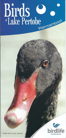 Warrnambool and District Historical Society Inc.
Document, Pamphlets lake Pertobe, 2014
... Lake Pertobe in Warrnambool is a former swamp area which was transformed into a recreational area and children’s playground in the 1970s. The reserve is a popular spot for bird watching with over 80 species found in the vicinity. ...Warrnambool and District Historical Society Inc. 2 Gilles Street (south of Merri St) Warrnambool great-ocean-road Lake Pertobe in Warrnambool is a former swamp area which was transformed into a recreational area and children’s playground in the 1970s. The reserve is a popular spot for bird watching with over 80 species found in the vicinity. ...Lake Pertobe in Warrnambool is a former swamp area which was transformed into a recreational area and children’s playground in the 1970s. The reserve is a popular spot for bird watching with over 80 species found in the vicinity. The brochure on Lake Pertobe’s birds had been produced by BirdLife Warrnambool, part of BirdLife Australia, an independent, not-for profit organisation aiming to protect our birdlife and disseminate information on Australian birds. This is an important little brochure as it contains information for locals and tourists about the birdlife in Lake Pertobe, one of the best-known and best-loved spots in WarrnamboolThis is an A3 sheet of paper printed on both sides and folded three times to form a brochure. It contains colour photographs of birds, two maps and information about BirdLife Warrnambool and BirdLife Australia and the logo of Birdlife Warrnambool.Front Cover: ‘Birds of Lake Pertobe, Warrnambool, BirdLife Warrnambool, Birds are in our nature’ lake pertobe, birdlife warrnambool, warrnambool -
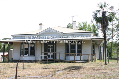 Eltham District Historical Society Inc
Photograph - Digital Photograph, Alan King, Edendale Farm Homestead, 29 January 2008
... The centre, with the Eltham North Reserve to the north - including remnant bushland and open parkland - makes up the major part of the public open space for this area. The council considers this area will become increasingly important to the local community for recreational use.2 Educational programs aim to encourage community involvement to ensure the long-term rehabilitation and protection of natural bushland areas. ...The centre, with the Eltham North Reserve to the north - including remnant bushland and open parkland - makes up the major part of the public open space for this area. The council considers this area will become increasingly important to the local community for recreational use.2 Educational programs aim to encourage community involvement to ensure the long-term rehabilitation and protection of natural bushland areas. ...Edendale Farm is Nillumbik Shire Council's environment centre situated in Gastons Road, Eltham between the railway and the Diamond Creek. The homestead on the property was built in 1896 and is of historical significance, being the subject of a Heritage Overlay under the Nillumbik Planning Scheme. The Edendale property was originally part of an extensive land purchase in 1852 from the Crown by pioneer Eltham farmer Henry Stooke. He initially purchased 51 acres and later expanded his holdings by purchasing another three adjacent Crown allotments extending northerly from Josiah Holloway's Little Eltham subdivision. Despite clearing the land, Stooke did not build on this property, choosing to live on his property "Rosehill" at Lower Plenty. In 1896 Thomas Cool, Club Manager of the Victoria Coffee Palace in Melbourne purchased 7 acres of the original Stooke land and built the house now known as Edendale. Cool did not farm the land, instead using it as a gentleman’s residence, retiring to Eltham at weekends. In 1918 he purchased an additional 7 acres but in 1919 he sold the property. Later owners included J.W. Cox, the Gaston family and D. Mummery. In the 1980s the Eltham Shire Council purchased the site for use as a Council depot, but this use did not proceed. Subsequently, it was used as the Council pound. The Edendale Farm Pet Education and Retention Centre was established in the summer of 1988/1989 and was set up to replace the existing dog kennels with a high standard pet retention centre. The design style of the building was established to compliment the features of the existing house. It was equipped with 10 retention pens, a veterinary room and a pet education area where school children and other interested parties learnt about pet care procedures. It was later developed into a community farm and was run by an advisory committee and in 2000 it became an Environment Centre. In early 2006 an advisory committee was established for the development of a master plan for future development at Edendale Farm. The committee included Russell Yeoman, a former long-time shire planner and founding member of the Eltham District Historical Society. At the time of filming the Master Plan and future for Edendale was about continuing to develop Edendale as a centre of environment learning and looking at expanding displays and school program, running a lot more of life-long learning and workshops around sustainable living. Covered under Heritage Overlay, Nillumbik Planning Scheme. Published: Nillumbik Now and Then / Marguerite Marshall 2008; photographs Alan King with Marguerite Marshall.; p101 A sharp turn from busy Wattletree Road by the railway line, brings a surprise. Only 1.4 km from Eltham’s centre, sheep feed, blissfully unaware of the hectic suburban activity so close by. At the entrance to the 5.6ha Edendale Farm is another surprise. A work of art that looks like huge tree trunks transformed into bowler and top-hatted men. The Fences Act 1968 by Tony Trembath with Mark Cain and John Doyle, 1996, is classified by the National Trust of Australia as having Regional Significance. The title refers to a government act on disputes between neighbors over the placement of fences and boundaries. This takes a ‘wry swipe’ at a community divided by trivial squabbles. It also celebrates making do with limited resources.1 Further along on the left, the office wall is decorated with a massive Eltham Copper Butterfly, designed by Robert Tickner and made by school children with used plastic bottles and other waste material. Nillumbik Council runs Edendale as an Environmental Education Centre, to help preserve and enhance the local environment. As early as 1988 the former Eltham Shire Council realised Edendale’s importance in meeting people’s needs, particularly of children, to enjoy farmland. The centre, with the Eltham North Reserve to the north - including remnant bushland and open parkland - makes up the major part of the public open space for this area. The council considers this area will become increasingly important to the local community for recreational use.2 Educational programs aim to encourage community involvement to ensure the long-term rehabilitation and protection of natural bushland areas. Edendale is used by people of all ages - from school children to adults - for environmental programs and workshops, as well as for recreation, to enjoy the domestic animals and to picnic. Edendale is also home to the Environmental Works staff who manage reserves and roadsides and support Nillumbik Friends environmental groups. The Friends propagate plants at the nursery, which grows indigenous plants and sells these to the public.3 The centre demonstrates the sustainable living the farm teaches, with features like solar hot water and drive lighting and for the fireplace, logs of recycled cardboard. Edendale has had a varied history as a dog pound and even as a retreat for Thomas Cool, Club Manager of the Victoria Coffee Palace in Melbourne. His single-storey weatherboard house built in 1896, which still stands, was grander than most homes in Eltham. Although such buildings were common in many other parts of Melbourne, Eltham’s poverty and remoteness did not encourage such construction. The Victorian rectangular-shaped house, with a corrugated iron roof and veranda, has elegant large rooms, leadlight windows, ceiling roses, two bay windows and ornately carved wooden fireplace surrounds. Cool bought seven acres (2.8ha) from pioneer Eltham farmer Henry Stooke’s 200 acre (81ha) farm, which he had bought from the Crown in 1852. In 1918 Cool bought an extra seven acres (2.8ha) but in 1919 sold the estate to farmer John Cox. In 1933 Cox sold Edendale to Mrs Elizabeth Gaston, after whom the road leading to the centre was named. The property was owned by several Gaston family members, who called it Edendale, then by a police constable, Douglas Mummery, until the Shire of Eltham bought it in 1970. Oddly Edendale was known as Mummery’s for almost 20 years, although Mummery owned it only for a short time.4 The shire used Edendale as a dog pound until amalgamation with other municipalities in 1996. The pound then moved to the Yan Yean Road, Plenty site, which had been used by the former Diamond Valley Shire Council. To the west and north the centre is bounded by Diamond Creek and on the east by the Melbourne-Hurstbridge railway line. Part of the Research creek forms the centre’s southern boundary.This collection of almost 130 photos about places and people within the Shire of Nillumbik, an urban and rural municipality in Melbourne's north, contributes to an understanding of the history of the Shire. Published in 2008 immediately prior to the Black Saturday bushfires of February 7, 2009, it documents sites that were impacted, and in some cases destroyed by the fires. It includes photographs taken especially for the publication, creating a unique time capsule representing the Shire in the early 21st century. It remains the most recent comprehenesive publication devoted to the Shire's history connecting local residents to the past. nillumbik now and then (marshall-king) collection, edendale farm -
 The Beechworth Burke Museum
Photograph, 1960
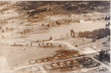
... This photograph represents additional construction to Lake Sambell as a recreational reserve. Beechworth Lake Lake Lake Sambell construction #beechworth australian landscape Beechworth 1960s Victoria Black and white reproduced rectangular photograph print on paper. ...Taken in 1960, depicted is the construction of Lake Sambell, looking west across the lake. Lake Sambell is a beautiful Victorian recreation lake and urban park with a unique history. It was created in the mid-1800s by the Rocky Mountain Mining company during the gold rush era and used as a mining site until the early 1900s, which brought Europeans into the area. It was turned into a reserve for residents in 1920 and is considered an icon of Beechworth as it represents the development of the community, human endeavour, and the spirit of the landscape.This photograph represents additional construction to Lake Sambell as a recreational reserve.Black and white reproduced rectangular photograph print on paper.beechworth lake, lake, lake sambell, construction, #beechworth, australian landscape, beechworth 1960s, victoria -
 The Beechworth Burke Museum
Photograph, 1960s
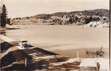
... reserve...Water Supply...political projects...environmental changes...Mr. L. H. Sambell...Sambell...Rocky Mountain Mining Company...recreational...Beechworth water scheme water reserve catchments Beechworth water reserve beechworth catchments Municipal Council lakes reserve Water Supply political projects environmental changes Mr. L. H. Sambell Sambell Rocky Mountain Mining Company recreational lake Minister of Lands Mr. ...Taken around 1960s, this photograph shows the banks of Lake Sambell. Lake Sambell is named after Mr. L. H. Sambell who was instrumental in the lake's formation. Lake Sambell is the original site of the open sluice operation of Rocky Mountain Mining Company in the 1800s and the early 1900s. In the early 1920s, it was reconstructed as a recreational lake and was formally opened to public on 6 October 1928. The opening event was attended by townspeople and Beechworth's Minister of Lands Mr. Bailey. In the late 1930s to early 1940s, Lake Sambell redeveloped. The first development aimed to raise the banks by six feet to double its present area and to make the water cleaner. Another redevelopment in the 1940s was made possible by the Beechworth and District Progress Association. It involved raising the banks to five feet to provide swimming facilities, paddling pool and caravan park. This photograph holds Historic significance because of its connection to the development of Beechworth district.Sepia rectangular photograph printed on matte photographic paperObverse: Reverse: 3533 /beechworth, water scheme, water reserve, catchments, beechworth water reserve, beechworth catchments, municipal council, lakes, reserve, water supply, political projects, environmental changes, mr. l. h. sambell, sambell, rocky mountain mining company, recreational lake, minister of lands, mr. bailey, swimming pool, paddling pool, caravan park, swimming facilities, lake redevelopment, funding -
 The Beechworth Burke Museum
Photograph, 1960s
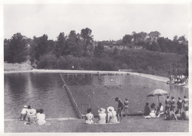
... This photograph represents the post-gold rush era use of Lake Sambell as a recreational reserve. Swimming carnivals were held at the lake and considered a social event for the Beechworth community. ...Taken in the 1960s, depicted are approximately twenty-nine male and female spectators at a school swimming carnival on Lake Sambell near the caravan park. Lake Sambell is a beautiful Victorian recreation lake and urban park with a unique history. It was created in the mid-1800s by the Rocky Mountain Mining company during the gold rush era and used as a mining site until the early 1900s, which brought Europeans into the area. It was turned into a reserve for residents in 1920 and is considered an icon of Beechworth as it represents the development of the community, human endeavour, and the spirit of the landscape. This photograph represents the post-gold rush era use of Lake Sambell as a recreational reserve. Swimming carnivals were held at the lake and considered a social event for the Beechworth community.Black and white reproduced rectangular photograph print on paper.Reverse: Community/ Swimming pool 1960s/ near the caravan park/ Lakes?lake swimming pool, lake swimming, beechworth carnival processions, carnival, #beechworth, beechworth 1960s, victoria -
 Eltham District Historical Society Inc
Film - Video (VHS), Phil Burke et al, Shire of Eltham Grants Commsission Submission (Series 69, Item 7), 1993
... reserve...planning applications...planning permits...ranger services...recreational...recreational facilities in hilly areas requires the acquisition of expensive river flats (views of cricket ground surrounded by hills) and where not possible, costly earthmoving required. Also, views highlighting extensive tracks of natural habitat home to significant bird, animal and plant life. Shire emphasises its commitment highlighted by the Eltham Copper Butterfly which the Shire maintains small pockets of bushland to ensure its survival at significant expense (views of Pauline Toner Copper Butterfly Reserve.) ...recreational facilities in hilly areas requires the acquisition of expensive river flats (views of cricket ground surrounded by hills) and where not possible, costly earthmoving required. Also, views highlighting extensive tracks of natural habitat home to significant bird, animal and plant life. Shire emphasises its commitment highlighted by the Eltham Copper Butterfly which the Shire maintains small pockets of bushland to ensure its survival at significant expense (views of Pauline Toner Copper Butterfly Reserve.) ...Shire of Eltham Archives: Series 69, Item 7 Opens with aerial views of the Shire, 85% of the shire covered by the Green wedge principal. Discusses the obligations required of the Shire to maintain the Green Wedge. The Shire covers over 27,000 hectares with a population in excess of 45,000 residents, more than 70% living in the southern 10% of the Shire in suburbs of Eltham, Montmorency, Lower Plenty and Research. 85% of the Shire in the more sparsely populated northern area which is covered by the Green Wedge. Council is committed to providing a parity of services to all residents such as garbage collection and maintenance of roads. Views of rubbish collection trucks in Montmorency. It is emphasised that the cost of these services in highly populated areas is relatively low whereas in the sparsely populated Green Wedge areas, considerable. There are hundreds of kilometres of roads throughout the Shire, many unmade and maintenance is high to check overhanging trees and erosion especially on the steep hills is expensive and disproportionate to servicing the population in the dense urban areas. Shows views of hilly gravel roads and graders at work maintaining them. Shows scenes of assessing planning applications in these rural areas which takes significantly more time as well as other services provided such as Meals on Wheels, building permits, Ranger services. Provision of recreational facilities in hilly areas requires the acquisition of expensive river flats (views of cricket ground surrounded by hills) and where not possible, costly earthmoving required. Also, views highlighting extensive tracks of natural habitat home to significant bird, animal and plant life. Shire emphasises its commitment highlighted by the Eltham Copper Butterfly which the Shire maintains small pockets of bushland to ensure its survival at significant expense (views of Pauline Toner Copper Butterfly Reserve.) Short interview with Pat Vaughan, Environmental Officer for the Shire discussing the Eltham Copper Butterfly who also mentions many other species in the Shire of high significance from bats to mammals to plants as well as the importance of the Green Wedge to Melbourne – the lungs of Melbourne - and ensuring the protection of very important habitat which requires a great deal of planning and management to look after. Views of Wingrove Park to emphasise this maintenance by machinery in some areas is too damaging and introduced species, etc must be removed by hand. Balancing the services and facilities expected by the community with the needs of the environment requires careful planning demands requires careful planning and the principals of the Green Wedge require constant attention in the face of growing need for housing. Director of Planning & Environment, Richard Allen advises there are approximately 1,300 planning permits and development applications each year ranging from simple subdivision, boundary realignments to further complicated non-urban developments for agricultural pursuits and the level of expertise required from architectural and engineering to land degradation, flora and fauna. Video finishes with aerial views and parklands, streetscapes and rural areas. VHS Video cassette Converted to MP4 file format 00:07:39; 89MBshire of eltham, video recording, shire of eltham archives, eltham shire council, eltham, building permits, cricket ground, development applications, eltham copper butterfly, garbage collection, graders, green wedge, lower plenty, meals on wheels, montmorency, pat vaughan, pauline toner reserve, planning applications, planning permits, ranger services, recreational facilities, research, richard allen, roads, rural areas, wingrove park, victoria grants commission -
 Eltham District Historical Society Inc
Photograph, Liz Pidgeon, Heritage Excursion; Maroondah Aqueduct, 3 September 2016, 3 September 2016
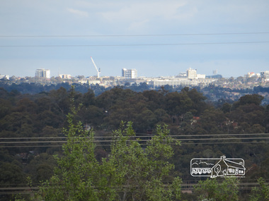
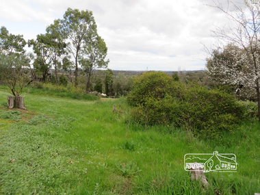
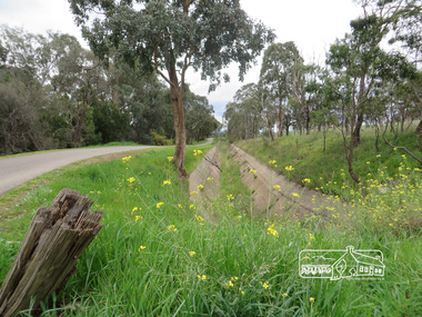
... A recreational path follows the aqueduct reserve. For our excursion on 3rd September we intend to walk along the section of the aqueduct adjacent to Allendale Road. ...A recreational path follows the aqueduct reserve. For our excursion on 3rd September we intend to walk along the section of the aqueduct adjacent to Allendale Road. ...Photo of Melbourne City skyline. Newsletter No., 229, August 2016 Heritage Excursion - Maroondah Aqueduct Walk - Saturday 3rd September The Maroondah Aqueduct was once a major link in Melbourne’s water supply system. It was built between 1886 and 1891 to transfer water from the Watts River near Healesville to the Preston Reservoir. It was 66 km in length, made up of 41 km of open channel, 10 km of tunnel through hills and 15 km of pipeline across stream valleys known as inverted siphons. The section of the aqueduct through the Eltham area has been abandoned since the 1980s but the open channel has largely been retained. A recreational path follows the aqueduct reserve. For our excursion on 3rd September we intend to walk along the section of the aqueduct adjacent to Allendale Road. This is a section not visited on previous excursions and includes the transition from open channel to the inverted siphon across the Diamond Creek valley. Apart from the aqueduct itself the main feature of the walk is the extensive views across Eltham North and Diamond Creek. Along the way we will talk about the history of the aqueduct and the area. This easy walk is about 3 km return and will take 2 to 2.5 hours. It will start at 2pm at the junction of Allendale Road with Godber Road and Zig Zag Road North, officially Diamond Creek, but on the northern boundary of Eltham. (Melway ref.12 B10). Born Digitalmaroondah aqueduct, eltham north, activities, eltham district historical society, heritage excursion, skyline, melbourne, aqueduct trail -
 Eltham District Historical Society Inc
Photograph, Liz Pidgeon, Heritage Excursion; Maroondah Aqueduct, 3 September 2016, 3 September 2016
... A recreational path follows the aqueduct reserve. For our excursion on 3rd September we intend to walk along the section of the aqueduct adjacent to Allendale Road. ...A recreational path follows the aqueduct reserve. For our excursion on 3rd September we intend to walk along the section of the aqueduct adjacent to Allendale Road. ...Newsletter No., 229, August 2016 Heritage Excursion - Maroondah Aqueduct Walk - Saturday 3rd September The Maroondah Aqueduct was once a major link in Melbourne’s water supply system. It was built between 1886 and 1891 to transfer water from the Watts River near Healesville to the Preston Reservoir. It was 66 km in length, made up of 41 km of open channel, 10 km of tunnel through hills and 15 km of pipeline across stream valleys known as inverted siphons. The section of the aqueduct through the Eltham area has been abandoned since the 1980s but the open channel has largely been retained. A recreational path follows the aqueduct reserve. For our excursion on 3rd September we intend to walk along the section of the aqueduct adjacent to Allendale Road. This is a section not visited on previous excursions and includes the transition from open channel to the inverted siphon across the Diamond Creek valley. Apart from the aqueduct itself the main feature of the walk is the extensive views across Eltham North and Diamond Creek. Along the way we will talk about the history of the aqueduct and the area. This easy walk is about 3 km return and will take 2 to 2.5 hours. It will start at 2pm at the junction of Allendale Road with Godber Road and Zig Zag Road North, officially Diamond Creek, but on the northern boundary of Eltham. (Melway ref.12 B10). Born Digitalmaroondah aqueduct, eltham north, activities, eltham district historical society, heritage excursion, acqueduct trail, spring -
 Eltham District Historical Society Inc
Photograph, Liz Pidgeon, Heritage Excursion; Maroondah Aqueduct, 3 September 2016, 3 September 2016
... A recreational path follows the aqueduct reserve. For our excursion on 3rd September we intend to walk along the section of the aqueduct adjacent to Allendale Road. ...A recreational path follows the aqueduct reserve. For our excursion on 3rd September we intend to walk along the section of the aqueduct adjacent to Allendale Road. ...Newsletter No., 229, August 2016 Heritage Excursion - Maroondah Aqueduct Walk - Saturday 3rd September The Maroondah Aqueduct was once a major link in Melbourne’s water supply system. It was built between 1886 and 1891 to transfer water from the Watts River near Healesville to the Preston Reservoir. It was 66 km in length, made up of 41 km of open channel, 10 km of tunnel through hills and 15 km of pipeline across stream valleys known as inverted siphons. The section of the aqueduct through the Eltham area has been abandoned since the 1980s but the open channel has largely been retained. A recreational path follows the aqueduct reserve. For our excursion on 3rd September we intend to walk along the section of the aqueduct adjacent to Allendale Road. This is a section not visited on previous excursions and includes the transition from open channel to the inverted siphon across the Diamond Creek valley. Apart from the aqueduct itself the main feature of the walk is the extensive views across Eltham North and Diamond Creek. Along the way we will talk about the history of the aqueduct and the area. This easy walk is about 3 km return and will take 2 to 2.5 hours. It will start at 2pm at the junction of Allendale Road with Godber Road and Zig Zag Road North, officially Diamond Creek, but on the northern boundary of Eltham. (Melway ref.12 B10). Born Digitalmaroondah aqueduct, eltham north, activities, eltham district historical society, heritage excursion, aqueduct trail, open channel