Showing 121 items matching "reef line maps"
-
 Bendigo Historical Society Inc.
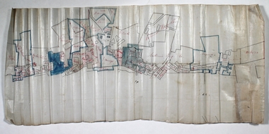
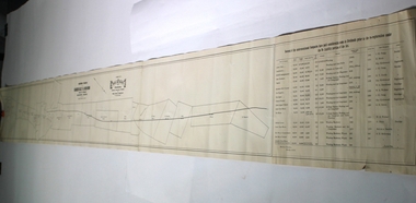
Map - SECTIONS ACROSS BENDIGO GOLDFIELD
... ...reef line maps...Map in three sections showing sections across Bendigo Gold Field, showing anticlines, synclines, faults, stratigraphical zones and mines along the reef lines. Key shows rock types Castlemaine, Bendigo B1, B2, B3 and B4, and Lancefieldian. First part of map shows sections A-A, B-B and C-C. Reef lines drawn with mines listed: Fault line...History House 11 Mackenzie Street Bendigo goldfields BENDIGO Gold mining reef line maps Geological Survey of Victoria Map in three sections showing sections across Bendigo Gold Field, showing anticlines, synclines, faults, stratigraphical zones and mines along the reef lines. ...Map in three sections showing sections across Bendigo Gold Field, showing anticlines, synclines, faults, stratigraphical zones and mines along the reef lines. Key shows rock types Castlemaine, Bendigo B1, B2, B3 and B4, and Lancefieldian. First part of map shows sections A-A, B-B and C-C. Reef lines drawn with mines listed: Fault line shown are the Carshalton, Stafford, New Chum, Virginia and Clarence. A datum line shows 600 ft above sea level. On bottom of plan: ' Prepared in the Geological Survey Office, Bendigo, under the direction of H. Herman, late Director of Geological Survey, from surveys by H.S. Whitelaw, Field Geologist, assisted by E.S. Usher, A.J.J. Moore and R.A. Keble.' Second section of map shows sections D-D, and E-E. Fault lines listed are the Tambour Major fault, Carshalton fault, Stafford fault, Nell Gwynne fault, New Chum fault, Deborah fault. Third section shows sections F-F and G-G. Fault lines listed are the Bird Reef fault, Kangaroo Gully fault, Langdon fault, Carshalton fault, Nell Gwynne fault, Spring Gully fault, Hustlers fault, Gravel Hill fault, Ordes fault, Thanet fault. This map forms part of the Geological Survey of Victoria, Structure of Bendigo Goldfield report, No. 47, 1923. H.Herman, late Director of Geological Survey.Geological Survey of Victoriabendigo, gold mining, reef line maps -
 Bendigo Historical Society Inc.
Plan - New Franklin
... White waxed paper, mining leases drawn along reef line. Handwritten annotations on map. Label states: Pearl, New Franklin on New Chum Line. 15 BC 304 printed on label of plan. ...gold mining gold Bendigo Pearl Gold Mine Franklin Gold Mine New Chum reef line White waxed paper, mining leases drawn along reef line. Handwritten annotations on map. ...White waxed paper, mining leases drawn along reef line. Handwritten annotations on map. Label states: Pearl, New Franklin on New Chum Line. 15 BC 304 printed on label of plan. Plan forms part of the Margaret Roberts Collection.gold mining, gold, bendigo, pearl gold mine, franklin gold mine, new chum reef line -
 Bendigo Historical Society Inc.
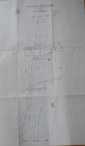
Map - HUSTLER'S ROYAL RESERVE NO 2 MINE - PLAN OF THE HUSTLER'S ROYAL RESERVE NO 2 MINE
... Line of Reefs. Also mentioned is the Lightning Hill Line of Reefs. Map shows some of the levels, approximate boundary of lease and the boundary of Lease No 8892 and 8897. ...Line of Reefs. Also mentioned is the Lightning Hill Line of Reefs. Map shows some of the levels, approximate boundary of lease and the boundary of Lease No 8892 and 8897. ...Plan of the Hustler's Royal Reserve No 2 Mine Bulletin No 33, Plate No V. Plan shows the Hustler's Royal Reserve No 2 (Main Shaft), Hustler's Royal Reserve No 2 (Park Shaft.), the Royal Hustler's, the Imperial Hustler's and the Extended Hustler's Freehold on the Hustler's Line of Reefs. Also mentioned is the Lightning Hill Line of Reefs. Map shows some of the levels, approximate boundary of lease and the boundary of Lease No 8892 and 8897. There are also street names and the locations of jail, lagoons, Post Office, Rosalind Park and the State School, High School and Continuation School. Geological Survey of Victoria emblem. H. Herman Director, W. Dickson, Secretary of Mines and The Hon. J. Drysdale Brown MLC, Minister of Mines. Signed by zh Whitdan, Underground Survey Office, Bendigo, September 1913.mining, parish map, hustler's royal reserve no 2 mine, royal hustler's, imperial hustler's, extended hustler's freehold, geological survey of victoria, h herman, w dickson, the hon j drysdale brown, h whitdan, hustler's line of reefs, lightning hill line of reefs -
 Bendigo Historical Society Inc.
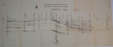
Map - HUSTLERS LINE OF REEFS - LONGITUDINAL SECTION THROUGH THE SADDLE REEFS
... reef maps...Hustlers Line of Reefs...Drawing with Longitudinal Section through the Saddle Reefs along portion of Hustler's Line of Reefs, Bendigo. Map shows the depth of the mines, reef numbers and Datum 700 ft above sea level. ...History House 11 Mackenzie Street Bendigo goldfields MINING hustler's reef maps Hustlers Line of Reefs Bendigo Creek Royal Hustler's Imperial Hustler's Extended Hustler's Freehold Great Extended Hustler's Tribute (Pups) Great Extended Hustler's Reef No 2 Great Extended Hustler's Main Shaft Hustler's Reef Hustler's Reef No 1 United Hustler's & Redan Old Shaft and Hustler's Consols.H S Whitelaw Underground Survey Office Bendigo September 1913 Geological Survey of Victoria Crest Drawing with Longitudinal Section through the Saddle Reefs along portion of Hustler's Line of Reefs, Bendigo. ...Drawing with Longitudinal Section through the Saddle Reefs along portion of Hustler's Line of Reefs, Bendigo. Map shows the depth of the mines, reef numbers and Datum 700 ft above sea level. North and South is also noted on the map. Map signed by H. S, Whitelaw, Underground Survey Office, Bendigo, September 1913. Bulletin No 33, Plate No XXXIV. Bendigo Creek, Ironbark Creek and Long Gully are also noted. Mines are: Fortuna Hustlers, Hustler's Royal Reserve No 2 Main Shaft, Hustler's Royal Reserve No 2 Park Shaft, Royal Hustler's, Imperial Hustler's, Extended Hustler's Freehold, Great Extended Hustler's Tribute (Pups), Old Shaft, Great Extended Hustler's Reef No 2, Great Extended Hustler's Main Shaft, Old Shaft, Hustler's Reef, Hustler's Reef No 1, Comet, K. K., United Hustler's & Redan, Old Shaft and Hustler's Consols. Has Geological Survey of Victoria Crest and underneath is: H. Herman, Director, W. Dickson, Secretary for Mines, The Hon. J Drysdale Brown M L C. Minister of Mines.Geological Survey of Victoria Crestmining, hustler's reef maps, hustlers line of reefs, bendigo creek, royal hustler's, imperial hustler's, extended hustler's freehold, great extended hustler's tribute (pups), great extended hustler's reef no 2, great extended hustler's main shaft, hustler's reef, hustler's reef no 1, united hustler's & redan, old shaft and hustler's consols.h s whitelaw, underground survey office bendigo september 1913 -
 Bendigo Historical Society Inc.
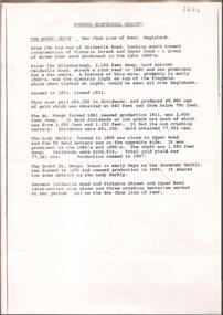
Map - NEW CHUM LINE, 1875
... History House 11 Mackenzie Street Bendigo goldfields MAP mining plan Gold Mines New Chum Line CALEB THOMAS 1875 Plan: Longtitudinal section of the Southern Section of the New Chum Line of Reef. ...Plan: Longtitudinal section of the Southern Section of the New Chum Line of Reef. Compilation consisting of small sections stapled togetherCALEB THOMAS 1875map, mining plan, gold mines, new chum line -
 Bendigo Historical Society Inc.
Map - NEW CHUM LINE, 1875
... MAP...new chum line...Gold mines... New Chum line of Reef...History House 11 Mackenzie Street Bendigo goldfields MAP new chum line Gold mines New Chum line of Reef Plan: Longtitudinal Section of the Northern Section of the New Chum Line of Reef. ...Plan: Longtitudinal Section of the Northern Section of the New Chum Line of Reef. Compilation consisting of smaller sections stapled togethermap, new chum line, gold mines, new chum line of reef -
 Bendigo Historical Society Inc.
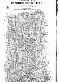
Map - LONG GULLY HISTORY GROUP COLLECTION: GEOLOGICAL MAP - BENDIGO GOLD FIELD
... History House 11 Mackenzie Street Bendigo goldfields BENDIGO History long gully history group The Long Gully History Group - Geological map - Bendigo Gold Field Mines Department H Herman Lightning Hill Line Hustlers Line Derby Line Paddy's Gully Line Garden Gully Line Deborah Line Sheepshead Line New Chum Line Nell Gwynne Line British and Foreign Line Napoleon Line Carshalton Line Thistle Line Christmas Line Lancashire Line Copy of a Geological Map of the Bendigo Gold Field. Map shows Lines of Reef ...Copy of a Geological Map of the Bendigo Gold Field. Map shows Lines of Reef, Anticlines, Synclines, Shafts, Alluvial Contours Gullies and some street names. Copy is hard to read. There are two pages.bendigo, history, long gully history group, the long gully history group - geological map - bendigo gold field, mines department, h herman, lightning hill line, hustlers line, derby line, paddy's gully line, garden gully line, deborah line, sheepshead line, new chum line, nell gwynne line, british and foreign line, napoleon line, carshalton line, thistle line, christmas line, lancashire line -
 Bendigo Historical Society Inc.
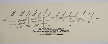
Map - SHEEPSHEAD LINE OF REEF, Circa 1940's
... MAP...Bendigo...mining plan...Sheepshead line of Reef...Map: Plan showing a Longitudinal section of the Sheepshead line of Reefs , Bendigo. (34 Copies)...History House 11 Mackenzie Street Bendigo goldfields MAP Bendigo mining plan Sheepshead line of Reef Gold mines Mining Map: Plan showing a Longitudinal section of the Sheepshead line of Reefs , Bendigo. (34 Copies) Map SHEEPSHEAD LINE OF REEF ...Map: Plan showing a Longitudinal section of the Sheepshead line of Reefs , Bendigo. (34 Copies)map, bendigo, mining plan, sheepshead line of reef, gold mines , mining -
 Bendigo Historical Society Inc.
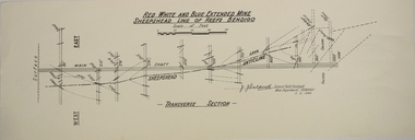
Map - RED WHITE AND BLUE EXTENDED MINE, 5/12/1940
... MAP...Bendigo...mining plan...Red White and Blue Extended Mine... Sheepshead line of Reef...Map: Transverse section of The Red, White and Blue Extended Mine, Sheepshead line of Reef, Bendigo...History House 11 Mackenzie Street Bendigo goldfields MAP Bendigo mining plan Red White and Blue Extended Mine Sheepshead line of Reef Mining Gold mines J.J. ...Map: Transverse section of The Red, White and Blue Extended Mine, Sheepshead line of Reef, Bendigo. (9 Copies). By J.J. Caldwell, District Field Geologist, Mines Department Bendigo 5.12.1940map, bendigo, mining plan, red white and blue extended mine, sheepshead line of reef, mining , gold mines, j.j. caldwell -
Bendigo Historical Society Inc.
Map - Sheepshead line of reef
... History House 11 Mackenzie Street Bendigo goldfields gold mining gold Sheepshead reef Red White and Blue Sheepshead line of reef Plan forms part of the Margaret Roberts Collection. Map ...Sheepshead line of reef Plan forms part of the Margaret Roberts Collection.gold mining, gold, sheepshead reef, red white and blue -
 Bendigo Historical Society Inc.
Plan - Garden Gully and New Moon Lines of Reef, J.B. Young, lithographer, Unknown
... Line of Reefs, Eaglehawk, Bendigo, Scale 8 chains to an inch'. Printed on right hand side of reef names: ' Issued by Wood And McNair, Sharebrokers, Beehive Chambers, Bendigo and High Street, Eaglehawk. J.B. Young, Lith. Bendigo.' On far right hand end of map...Line of Reefs, Eaglehawk, Bendigo, Scale 8 chains to an inch'. Printed on right hand side of reef names: ' Issued by Wood And McNair, Sharebrokers, Beehive Chambers, Bendigo and High Street, Eaglehawk. J.B. Young, Lith. Bendigo.' On far right hand end of map ...Printed on buff coloured light paper, written on top centre of plan: ' Northern Portion of Garden Gully & New Moon Line of Reefs, Eaglehawk, Bendigo, Scale 8 chains to an inch'. Printed on right hand side of reef names: ' Issued by Wood And McNair, Sharebrokers, Beehive Chambers, Bendigo and High Street, Eaglehawk. J.B. Young, Lith. Bendigo.' On far right hand end of map, a table of information headed ' Several of the undermentioned Companies have paid considerable sums in Dividends prior to the re-registration under the No Liability portion of the Act'. Table contains information on the name of Company; No. of shares; nominal capital,; Capital called up; call per share; dividends; machinery; present depth of shaft; bottom plat; Legal Managers; address. On bottom of table, 'Beehive Chambers, Bendigo 6/8/03'. Plan shows mines along the reef lines with distance in yards of each claim - from SSW direction: Golden Pyke Company, McDuff Amalgamated, Constellation Company, Virginia Company, Specimen Hill Company, New Hopeful, New Argus Company, Clarence Company, North Argus Company, South New Moon Company, New Moon Company, Suffolk Tribute Company, North New Moon Company, New Moon Consolidated Company, New Moon United Company, Adelaide New Moon Company, J. Davies, Day & Co., (lease applied for by P. Booth), P. Booth, D. Murdoch, J. Mani, F. Bassett and R. Bassett. Mine map is part of the Margaret Roberts Collection. gold mining, gold, margaret roberts collection, garden gully, new moon, reef lines, golden pyke company, mcduff amalgamated, constellation company, virginia company, specimen hill company, new hopeful, new argus company, clarence company, north argus company, south new moon company, new moon company, suffolk tribute company, north new moon company, new moon consolidated company, new moon united company, adelaide new moon company, j. davies, day & co., (lease applied for by p. booth), p. booth, d. murdoch, j. mani, f. bassett and r. bassett. -
 Bendigo Historical Society Inc.
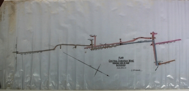
Plan - Central Deborah Gold Mine, J.J. Caldwell, 1945
... Line of Reef, Bendigo, Scale 30 ft = 1 in.' Signature of J.J. Caldross, 13.10.45, written below name of mine. Handwritten on outside of plan in black pen: 'Mines Department, Cent. Deborah, Transverse section, Plan of levels' Plan notation shows No. 8 level on east leg of inner reef, level of east leg on outer reef, outer back, west leg, main shaft, numbers 5, 6, 7 and 10 levels. Mine map...Line of Reef, Bendigo, Scale 30 ft = 1 in.' Signature of J.J. Caldross, 13.10.45, written below name of mine. Handwritten on outside of plan in black pen: 'Mines Department, Cent. Deborah, Transverse section, Plan of levels' Plan notation shows No. 8 level on east leg of inner reef, level of east leg on outer reef, outer back, west leg, main shaft, numbers 5, 6, 7 and 10 levels. Mine map ...The Central Deborah Gold Mine is situated at 76 Violet Street, Bendigo. The mine operated from 1939 through to 1954 and extracted 929 kg of gold. The Central Deborah Gold Mine is a non-active gold mine and tourist attraction in Bendigo, Australia. It was listed on the Victorian Heritage Register on 18 November 1999.[1] The mine was opened in 1939 by the Central Deborah Gold Mining Company during a 1930s revival of the gold industry, extending an existing 108 ft shaft from many years earlier with new machinery. It was one of the last mines to open on the Bendigo goldfields and one of the few to stay open during World War II. It was expanded during 1945–46, with extensions and new machinery. It reached its maximum depth (now recorded as 412m) during the 1940s. It closed in November 1954, having produced 29,865 ounces of gold in its lifetime; the closure of the North Deborah Mine two weeks later marked the last mine in Bendigo to close Central Deborah Gold Mine is now a tourist destination, operated by Bendigo Heritage Attractions: https://www.central-deborah.com/about-us/central-deborah-gold-mine-s-history Blue waxed paper, features on plan drawn in pale pink and blue, title written in black text on centre bottom: 'Plan, Central Deborah Mine, Deborah Line of Reef, Bendigo, Scale 30 ft = 1 in.' Signature of J.J. Caldross, 13.10.45, written below name of mine. Handwritten on outside of plan in black pen: 'Mines Department, Cent. Deborah, Transverse section, Plan of levels' Plan notation shows No. 8 level on east leg of inner reef, level of east leg on outer reef, outer back, west leg, main shaft, numbers 5, 6, 7 and 10 levels. Mine map is part of the Margaret Roberts Collection. gold mining, gold, margaret roberts collection, central deborah gold mine, violet street, tourist attraction, bendigo -
 Bendigo Historical Society Inc.
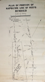
Plan - Part of Napoleon and Nell Gwynne Reefs
... Black printing on off white colored paper- PLAN OF PORTION OF NAPOLEON LINE OF REEFS BENDIGO, Scale of Chains, a signature, District Geologist Mines Department BENDIGO. 5/12/39 Two vertical broken lines are labeled NAPOLEON LINE OF REEFS, NELL GYWNNE LINE OF REEFS and CENTRAL NAPOLEON LODE CHANNEL and mine shafts CENTRAL NAPOLEON, MOONTA, PTOPOSED NEW SHAFT, NORTH NEW GWYNNE, THREE TOMS, NEW CHUM SYNCLINE and CENTRAL NELL GWYNNE are drawn over a street map of the Long Gully area. ...Map Mine Long Gully J.J. Caldwell Black printing on off white colored paper- PLAN OF PORTION OF NAPOLEON LINE OF REEFS BENDIGO, Scale of Chains, a signature, District Geologist Mines Department BENDIGO. 5/12/39 Two vertical broken lines are labeled NAPOLEON LINE OF REEFS, NELL GYWNNE LINE OF REEFS and CENTRAL NAPOLEON LODE CHANNEL and mine shafts CENTRAL NAPOLEON, MOONTA, PTOPOSED NEW SHAFT, NORTH NEW GWYNNE, THREE TOMS, NEW CHUM SYNCLINE and CENTRAL NELL GWYNNE are drawn over a street map of the Long Gully area. ...Mr. J. J. Caldwell, Officer in charge of the Bendigo Geological branch of the Victorian Mines Department, received his early training in the Castlemaine and Bendigo Schools of Mines and later at the Melbourne Technical CollegeBlack printing on off white colored paper- PLAN OF PORTION OF NAPOLEON LINE OF REEFS BENDIGO, Scale of Chains, a signature, District Geologist Mines Department BENDIGO. 5/12/39 Two vertical broken lines are labeled NAPOLEON LINE OF REEFS, NELL GYWNNE LINE OF REEFS and CENTRAL NAPOLEON LODE CHANNEL and mine shafts CENTRAL NAPOLEON, MOONTA, PTOPOSED NEW SHAFT, NORTH NEW GWYNNE, THREE TOMS, NEW CHUM SYNCLINE and CENTRAL NELL GWYNNE are drawn over a street map of the Long Gully area. The streets shown are; Empire Rd, Harvey St, Inglis St, Wells St, Union St, Alley St (now Marong Rd) and Curnow St. Forms part of the Margaret Roberts Collection bendigo, margaret roberts, gold, map, mine, long gully, j.j. caldwell -
 Bendigo Historical Society Inc.
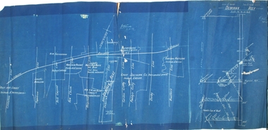
Plan - Deborah Reef, 19th December, 1917
... Deborah railway line Deborah Gold Mine Deborah Reef cross section N. Cundy, 19.12.17 Blue paper map, white text and plan, showing reef lines. ...Blue paper map, white text and plan, showing reef lines. Same plan as 11270.71, with addition of Deborah Reef cross section, on extreme right of plan. N. Cundy, 19.12.17gold mining, gold, bendigo, whip and jersey, carshalton, napoleon, nell gwynne, new chum, sheepshead, garden gully, paddy gully, derby, hustlers., deborah, railway line, deborah gold mine, deborah reef, cross section -
 Bendigo Historical Society Inc.
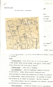
Document - ALBERT RICHARDSON COLLECTION: NEW MOON MINE, EAGLEHAWK
... Four-page typed document with map, detailing the history and plant of the New Moon Gold Mine on the Garden Gully line of reef. ...searchTerm=rain BENDIGO Mining new moon mine William Vinton gold rain lightning Four-page typed document with map, detailing the history and plant of the New Moon Gold Mine on the Garden Gully line of reef. ...The New Moon Company was registered by William Vinton in the Victorian Government Gazette (45) on Friday 8th July, 1870. (page 984), The place of operation was Napoleon Gully, Eaglehawk, Bendigo. Nominal capital was £24,000 pounds; shares being £1 . The names of the shareholders and number of shares held, was as follows: Nicholas Jeffrey 9000 shares, James Forde Graham 6000 shares, Joseph Harris, 1500 shares, John Wearne 1500 shares, John H. Hay, 1500 shares, Thomas Grieve 1500 shares, Henry Young 1500 shares, Alfred Wainright 1500 shares. With the exception of Wainwright, all shareholders lived in Eaglehawk. Alfred Wainright gave his address as 'Ireland'. On 23rd August, 1870, William Vinton, Mine Manager, reported that 'during the last fortnight we have crushed 294 loads of stone for 188 ounces 11 dwts of gold; 100 load still on surface, the roads being in such a bad state, we have been unable to cart it to the machine'. (Bendigo Advertiser, 23rd August, 1870, page 3 'Mining Intelligence') Heavy rain had fallen in Sandhurst the previous week: 'in the space of seven or so minutes, 3/4 of an inch of rain fell....in one of the severest storms to visit the district in many years' (Bendigo Advertiser, 18 August 1870, 'Dreadful storm and loss of life by lightning'). https://trove.nla.gov.au/newspaper/article/87913524?searchTerm=rainFour-page typed document with map, detailing the history and plant of the New Moon Gold Mine on the Garden Gully line of reef. The mine was located approximately one mile north of Eaglehawk Town Hall. The depth of the shaft was 2,400 ft. The mine was first formed in 1867. The signaling system in the mine was electric with a telephone service which connected the engine driver with the plat chamber. At most mines, when the men were below the surface, the men could signal to the driver, but he could not communicate with them. Total gold production from the mine was 230,601 ozs.bendigo, mining, new moon mine, william vinton, gold, rain, lightning -
 Bendigo Historical Society Inc.
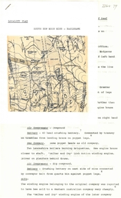
Document - ALBERT RICHARDSON COLLECTION: SOUTH NEW MOON MINE EAGLEHAWK
... Two-page typed document with map, detailing information on the South New Moon Gold Mine on the Garden Gully line of reef. ...History House 11 Mackenzie Street Bendigo goldfields BENDIGO Mining south new moon gold mine Two-page typed document with map, detailing information on the South New Moon Gold Mine on the Garden Gully line of reef. ...Two-page typed document with map, detailing information on the South New Moon Gold Mine on the Garden Gully line of reef. Information includes the location, depth of shaft, steel poppet legs, engine house, air compressor, battery, company ownership, battery. The shaft The 'Walker and Coy' winding engine of the later company together with poppet heads was removed later to the South Virginia company between Napier and Market Street, Eaglehawk. Gold production from both companies who owned the mine was 257,498 oz.'.bendigo, mining, south new moon gold mine -
 Bendigo Historical Society Inc.
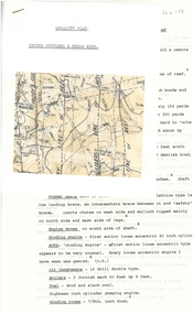
Document - ALBERT RICHARDSON COLLECTION: UNITED HUSTLERS AND REDAN MINE
... map. The United Hustlers and Redan mine was located in the North Bendigo, Long Gully area on the Hustlers line of reef. ...map. The United Hustlers and Redan mine was located in the North Bendigo, Long Gully area on the Hustlers line of reef. ...Four-page typed document plus location map. The United Hustlers and Redan mine was located in the North Bendigo, Long Gully area on the Hustlers line of reef. The lease was 153 acres and included Holdsworth, Holmes, Havilah Roads and Wood Street. The Redan shaft was 1,830ft and the South or K.K. Shaft was 1,960 ft. Poppet legs steel 71 ft high. Features of the plant are described including the engine house, winding engine, air compressor, boilers, fuel, winding ropes.bendigo, mining, united hustlers and redan mine -
Bendigo Historical Society Inc.
Map - PLAN NEW CHUM LINE OF REEF
... History House 11 Mackenzie Street Bendigo goldfields PLAN Bendigo new chum line of reef Plan showing outcrops of reefs on supposed extension south of the New Chum line of reef from the Eureka extended company's ground. Scale 8 chains to 1 inch Map ...Plan showing outcrops of reefs on supposed extension south of the New Chum line of reef from the Eureka extended company's ground. Scale 8 chains to 1 inchplan, bendigo, new chum line of reef -
 Bendigo Historical Society Inc.
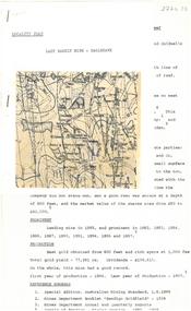
Document - ALBERT RICHARDSON COLLECTION: LADY BARKLY MINE, EAGLEHAWK
... One page document, plus map, with information on the Lady Barkly Mine, New Chum line of reef, Eaglehawk. ...History House 11 Mackenzie Street Bendigo goldfields BENDIGO Mining lady barkly mine eaglehawk One page document, plus map, with information on the Lady Barkly Mine, New Chum line of reef, Eaglehawk. ...One page document, plus map, with information on the Lady Barkly Mine, New Chum line of reef, Eaglehawk. The location, early history, prominence, and gold production are described. References given on bottom of document. Document forms part of research referred to in Albert Richardson's paper 2264.70.bendigo, mining, lady barkly mine eaglehawk -
 Bendigo Historical Society Inc.
Document - ALBERT RICHARDSON COLLECTION: NEW RED, WHITE AND BLUE CONSOLIDATED MINE, GOLDEN SQUARE
... Two-page document plus map showing location of the New Red, White and Blue Consolidated mine on the Sheepshead Line of Reef. ...line of reef. The main shaft was one of the largest on the field. It had a tall set of steel poppet legs, with a big slope at the front. High landing brace connected to crushing battery close to engine house. The main shaft was the original 'Union" (Albert Richardson notes) and the No. 3 shaft the old New Red White and Blue. BENDIGO Mining new red white and blue mine Two-page document plus map ...The New Red White and Blue Mine, Sheepshead line of reef, was located in Thistle Street, Golden Square. It was also known as the 'Big Blue'. The mine was formed in 1888, by the amalgamation of the Union and New Red White and Blue. The area of the claim was 32 acres; 781 yards along the line of reef. The main shaft was one of the largest on the field. It had a tall set of steel poppet legs, with a big slope at the front. High landing brace connected to crushing battery close to engine house. The main shaft was the original 'Union" (Albert Richardson notes) and the No. 3 shaft the old New Red White and Blue. Two-page document plus map showing location of the New Red, White and Blue Consolidated mine on the Sheepshead Line of Reef. Information on the mine is given in the following areas: location plant, early history, its role as a leading mine, its prominence, its closure, gold production. References are provided. Document forms part of research referred to in Albert Richardson's paper 2264.70.bendigo, mining, new red white and blue mine -
 Bendigo Historical Society Inc.
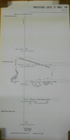
Document - UNDERGROUND SURVEY OF BENDIGO MINES
... line of reef. Report on the New Chum Railway Reserve Company and the Shenandoah Company, the New Chum Railway Co being immediately south and the Shenandoah Co immediately north of the railway line. Two maps...History House 11 Mackenzie Street Bendigo goldfields BENDIGO Mining garden gully line of reef mines Jems Stirling, geologist and W.H Cundy Underground Surveyor, Department of Mines Two page document, 'Underground survey of Bendigo, report on Constellation Company's Mine on northern extension of the Garden Gully line of reef. Report on the New Chum Railway Reserve Company and the Shenandoah Company, the New Chum Railway Co being immediately south and the Shenandoah Co immediately north of the railway line. Two maps ...Two page document, 'Underground survey of Bendigo, report on Constellation Company's Mine on northern extension of the Garden Gully line of reef. Report on the New Chum Railway Reserve Company and the Shenandoah Company, the New Chum Railway Co being immediately south and the Shenandoah Co immediately north of the railway line. Two maps Constellation Co. Mine shaft and New Chum Railway and Shenandoah auriferous reef below 2700 feet.Jems Stirling, geologist and W.H Cundy Underground Surveyor, Department of Minesbendigo, mining, garden gully line of reef mines -
 Bendigo Historical Society Inc.
Document - GARDEN GULLY LINE OF REEF, LEASE BLOCKS 5360 AND 5361
... line of reef, Bendigo. Produced by the Department of Mines 1899. The area described is about 'one mile and a quarter southeast from the centre of the city of Bendigo, immediately south of the Great Southern Gold Mining Company's workings and is intersected by two auriferous gullies ... Salomon's Gully and Derwenter's Gully'. The alluvial deposits, the Garden Gully line, the Great Souther Co.and old workings are discussed in the paper. A map... of the Garden Gully line of reef is attached to the report, showing claimholders and mine names along that section of the reef. Mines named on the map ...Two page document titled ' Report on lease blocks Nos. 5360 and 5361 Garden Gully line of reef, Bendigo. Produced by the Department of Mines 1899. The area described is about 'one mile and a quarter southeast from the centre of the city of Bendigo, immediately south of the Great Southern Gold Mining Company's workings and is intersected by two auriferous gullies ... Salomon's Gully and Derwenter's Gully'. The alluvial deposits, the Garden Gully line, the Great Souther Co.and old workings are discussed in the paper. A map of the Garden Gully line of reef is attached to the report, showing claimholders and mine names along that section of the reef. Mines named on the map: Great Southern Garden Gully United Ulster Londonderry Burrows Horwoods Sea Amalgamated Garden Gully United Victory and Pandora Unity Carlisle and Garden Gully and Passbye United Cornish United Koch's PioneerJames Stirling, Government Geologistbendigo, mining, garden gully line of reef mines -
 Bendigo Historical Society Inc.
Document - NEW CHUM LINE OF REEF MUNGO GROUP EAGLEHAWK
... line of reef, Eaglehawk. The mines described are: Ellenborough, 2100 feet deep St Mungo, 2,600 feet deep The Lady Barkly, 1,350 feet deep, close to Upper Road with a 40 head battery on the other side. South St Mungo, known as the Governor Barkly in the earlier days. Small map...line of reef, Eaglehawk. The mines described are: Ellenborough, 2100 feet deep St Mungo, 2,600 feet deep The Lady Barkly, 1,350 feet deep, close to Upper Road with a 40 head battery on the other side. South St Mungo, known as the Governor Barkly in the earlier days. Small map ...Two page document detailing the Mungo Group of Mines along the New Chum line of reef, Eaglehawk. The mines described are: Ellenborough, 2100 feet deep St Mungo, 2,600 feet deep The Lady Barkly, 1,350 feet deep, close to Upper Road with a 40 head battery on the other side. South St Mungo, known as the Governor Barkly in the earlier days. Small map on second page shows the location of the Sadowa shaft, St. Mungo shaft and the Lady Barkly shaft. Victoria Street and Upper Road marked on the map. 'Between Caldwells Road and Victoria Street and Upper Road intersection, nine mines and three crushing batteries worked at one period. All on the New Chum line of reef.' Not signed but most probably written by Albert Richardson.bendigo, mining, mungo group of mines, eaglehawk -
 Bendigo Historical Society Inc.
Document - BENDIGO AND VICTORIA HILL REPORT ON GEOLOGY
... Report contains: Cobaw batholith and North Harcourt Bendigo goldfield generally Trought, reefs, saddles and spurs Victoria Hill mines; Victoria Consols, Great Central Victoria, Victoria Quartz, Lansells 180, North Old Chum. Maps attached show part of New Chum line...Report contains: Cobaw batholith and North Harcourt Bendigo goldfield generally Trought, reefs, saddles and spurs Victoria Hill mines; Victoria Consols, Great Central Victoria, Victoria Quartz, Lansells 180, North Old Chum. Maps attached show part of New Chum line ...Report, 8 pages, on the geology of Bendigo district and Victoria Hill, produced by the Geological Survey Dept., Victorian Government. G.J. Medwell, Geologist. 19.10.1967. On front 'Geological Survey of Victoria. Mines Department Victoria. Report on Geology of Bendigo and of Victoria Hill Area' Letter attached inside front cover to J.C.Balfour, Minister of Mines to G.A. Lambert, Liberal Party, Sunshine, Victoria, sent with book for his information. Report contains: Cobaw batholith and North Harcourt Bendigo goldfield generally Trought, reefs, saddles and spurs Victoria Hill mines; Victoria Consols, Great Central Victoria, Victoria Quartz, Lansells 180, North Old Chum. Maps attached show part of New Chum line of reef and a handdrawn map of Rae's Cutting.bendigo, mining, victoria hill, bendigo goldfield -
 Bendigo Historical Society Inc.
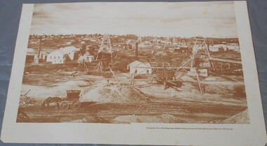
Photograph - Photograph of New Chum Line of Reef
... History House 11 Mackenzie Street Bendigo goldfields BHS Collection Bendigo Mines New Chum Line of Reef Mining On the back a drawing of a poppet head with the words: Bendigo gold project. A small map ...BHS CollectionSepia coloured print of a photograph of the New Chum Line of Reef looking south from the Snobs Hill group of mines. The photo shows several poppet heads and chimneys, bridges and houses. New Chum Line of Reef. includes Victoria Hill possibly the richest spot on the field.On the back a drawing of a poppet head with the words: Bendigo gold project. A small map of Victoria is also printed on the back. bendigo mines, new chum line of reef, mining -
Bendigo Historical Society Inc.
Map - MAP: VIRGINIA MINE GARDEN GULLY LINE OF REEF
... MAP: VIRGINIA MINE GARDEN GULLY LINE OF REEF...Map of Virginia Mine on the Garden Gully line of reef, Eaglehawk, transverse section. ...line of reef. Geological Survey Victoria, Geological Survey Office, Bendigo. Map of Virginia Mine on the Garden Gully line of reef, Eaglehawk, transverse section. ...Map of Virginia Mine on the Garden Gully line of reef, Eaglehawk, transverse section. Shaft, levels and Garden Gully anticlinal axial line drawn. Key shows types of formations - quartz, spurs, sandstone, slate, cleavage, lava. This map forms part of the Geological Survey of Victoria, Structure of Bendigo Goldfield report, No. 47, 1923. H.Herman, late Director of Geological Survey.Geological Survey Victoria, Geological Survey Office, Bendigo.bendigo, gold mining, virgina mine eaglehawk, eaglehawk, bendigo, gold mining, virginia mine, garden gully line of reef. -
Bendigo Historical Society Inc.
Map - BENDIGO GOLDFIELD VERTICAL PROJECTIONS
... Map of Bendigo Gold Field in two sections showing 'vertical projections along several anticlinal axial planes showing pitch, stratigraphical zones, faultlines, shafts and etc.'. Bulletin No 47 written top left hand side. Lines of reef described: Christmas line...History House 11 Mackenzie Street Bendigo goldfields BENDIGO Gold mining reef lines Geological Survey of Victoria Map of Bendigo Gold Field in two sections showing 'vertical projections along several anticlinal axial planes showing pitch, stratigraphical zones, faultlines, shafts and etc.'. Bulletin No 47 written top left hand side. Lines of reef described: Christmas line ...Map of Bendigo Gold Field in two sections showing 'vertical projections along several anticlinal axial planes showing pitch, stratigraphical zones, faultlines, shafts and etc.'. Bulletin No 47 written top left hand side. Lines of reef described: Christmas line Lancashire line Nell Gwynne line New Chum line Hustlers line Garden Gully line Sheepshead line Mines along the reef lines are listed. This map forms part of the Geological Survey of Victoria, Structure of Bendigo Goldfield report, No. 47, 1923. H.Herman, late Director of Geological Survey. On bottom of second section : Prepared in the Geological Survey Office, Bendigo, under the direction of H. Herman, late Director of Geological Survey, from surveys by H.S. Whitelaw, Field Geologist, assisted by E.S. Usher, A.J.J. Moore and R.A. Keble.Geological Survey of Victoriabendigo, gold mining, reef lines -
 Bendigo Historical Society Inc.
Document - MARKS COLLECTION: NEW CHUM LINE OF REEF MAP
... MARKS COLLECTION: NEW CHUM LINE OF REEF MAP...line of reef Plan (copy) of New Chum Line of Reef. Plan has been copied in two sections. On top of plan 'Underground survey of mines Sandhurst, New Chum Line of Reef', plan shows longitudinal and cross section views of the workings on the reef. Shaft No. 76 marked. Datum line on top indicates 750' above sea level, on bottom of plan, bottom of shaft 2022.24 below sill. Drawn by Arthur Everett, Mining Department, Melbourne, 1884. Document MARKS COLLECTION: NEW CHUM LINE OF REEF MAP ...Plan (copy) of New Chum Line of Reef. Plan has been copied in two sections. On top of plan 'Underground survey of mines Sandhurst, New Chum Line of Reef', plan shows longitudinal and cross section views of the workings on the reef. Shaft No. 76 marked. Datum line on top indicates 750' above sea level, on bottom of plan, bottom of shaft 2022.24 below sill. Drawn by Arthur Everett, Mining Department, Melbourne, 1884.bendigo, mining, new chum line of reef -
 Bendigo Historical Society Inc.
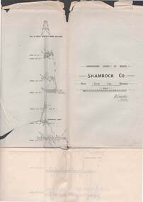
Map - STRUGNELL COLLECTION: UNDERGROUND SURVEY OF MINES BENDIGO, 27-3-01
... Map, Underground Survey of Mines, Shamrock Co., New Chum Line, Bendigo. Transverse Section, Garibaldi Reef, Young Chum Reef, Thorpe's Reef, Mundic Reef, Shenandoah Reef, New Chum Railway Reef, Surveyed under the Supervision of H.Herman....Map, Underground Survey of Mines, Shamrock Co., New Chum Line, Bendigo. Transverse Section, Garibaldi Reef, Young Chum Reef, Thorpe's Reef, Mundic Reef, Shenandoah Reef, New Chum Railway Reef, Surveyed under the Supervision of H.Herman. ...Map, Underground Survey of Mines, Shamrock Co., New Chum Line, Bendigo. Transverse Section, Garibaldi Reef, Young Chum Reef, Thorpe's Reef, Mundic Reef, Shenandoah Reef, New Chum Railway Reef, Surveyed under the Supervision of H.Herman.H.S.Whitelaw.map, bendigo, shamrock co. -
 Bendigo Historical Society Inc.
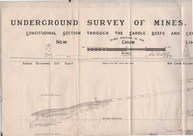
Map - STRUGNELL COLLECTION: NEW CHUM LINE OF REEF, 5/4/01
... Map, Along portion of the New Chum Line, Underground Survey of Mines, Bendigo, Longitudinal Section through the Saddle Reefs and Centre Country. ...History House 11 Mackenzie Street Bendigo goldfields MAP Bendigo new chum line H.S.Whitelow Map, Along portion of the New Chum Line, Underground Survey of Mines, Bendigo, Longitudinal Section through the Saddle Reefs and Centre Country. ...Map, Along portion of the New Chum Line, Underground Survey of Mines, Bendigo, Longitudinal Section through the Saddle Reefs and Centre Country. Eureka Extended Co's shaft, New Chum Railway Co's shaft. Surveyed under the supervision of H.Herman, B.C.E., F.G.S., Acting Government Geologist.H.S.Whitelowmap, bendigo, new chum line