Showing 24 items matching "reichelt avenue montmorency"
-
 Greensborough Historical Society
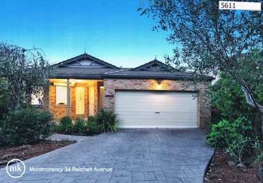
Advertising Leaflet, 34 Reichelt Avenue Montmorency, 25/11/2012
... 34 Reichelt Avenue Montmorency...reichelt avenue montmorency...34 Reichelt Avenue Montmorency. 4 bedroom home, private sale, sold 25/11/2012 for $725,000...Greensborough Historical Society 34A Glenauburn Road Lower Plenty Lower Plenty melbourne 34 Reichelt Avenue Montmorency. 4 bedroom home, private sale, sold 25/11/2012 for $725,000 reichelt avenue montmorency Real estate advertising leaflet, 1 sheet, printed in colour both sides 34 Reichelt Avenue Montmorency Advertising Leaflet Morrison Kleeman Real Estate ...34 Reichelt Avenue Montmorency. 4 bedroom home, private sale, sold 25/11/2012 for $725,000Real estate advertising leaflet, 1 sheet, printed in colour both sidesreichelt avenue montmorency -
 Eltham District Historical Society Inc
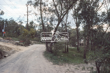
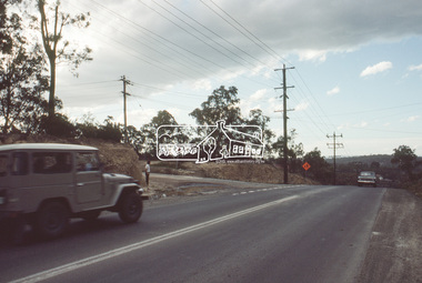
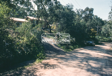
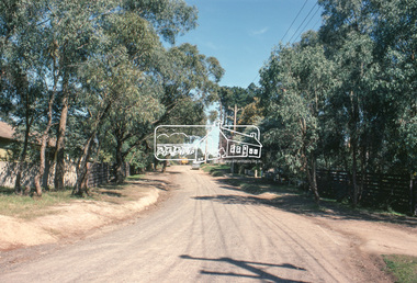
Slide, Reichelt Avenue, Montmorency at intersection with Bolton Street (now closed), c.Oct. 1980
... Reichelt Avenue, Montmorency at intersection with Bolton Street (now closed)...Montmorency...Reichelt Avenue...Bolton Steet Eltham Infrastructure Montmorency Reichelt Avenue Roads Processed Oct 1980 35 mm colour positive transparency Mount - Kodak Kodachrome Card Reichelt Avenue, Montmorency at intersection with Bolton Street (now closed) Slide Slide ...One of a series of images of roads and infrastructure focussed on the Quinn Estate in Montmorency taken by Eltham Shire Council Planning and Engineering officers. They provide perspective of the changes in housing styles and road development that began sweeping in from the mid 1970s with increasing urbanisation of what was once more outlying suburbs and regions.35 mm colour positive transparency Mount - Kodak Kodachrome CardProcessed Oct 1980bolton steet, eltham, infrastructure, montmorency, reichelt avenue, roads -
 Eltham District Historical Society Inc
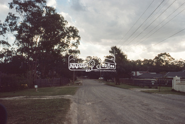
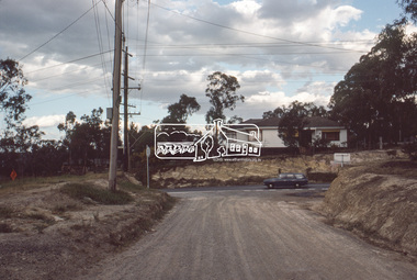
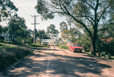
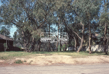
Slide, Reichelt Avenue, Montmorency at T-bowl near no. 27, c.Oct. 1980
... Reichelt Avenue, Montmorency at T-bowl near no. 27...Montmorency...Reichelt Avenue...Infrastructure Montmorency Reichelt Avenue Roads T-bowl Processed Oct 1980 35 mm colour positive transparency Mount - Kodak Kodachrome Card Reichelt Avenue, Montmorency at T-bowl near no. 27 Slide Slide ...One of a series of images of roads and infrastructure focussed on the Quinn Estate in Montmorency taken by Eltham Shire Council Planning and Engineering officers. They provide perspective of the changes in housing styles and road development that began sweeping in from the mid 1970s with increasing urbanisation of what was once more outlying suburbs and regions.35 mm colour positive transparency Mount - Kodak Kodachrome CardProcessed Oct 1980infrastructure, montmorency, reichelt avenue, roads, t-bowl -
 Eltham District Historical Society Inc
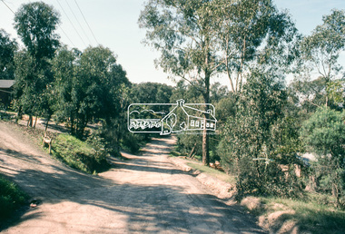
Slide, Intersection of Reichelt Avenue, Montmorency at Bolton Street, c.Oct. 1980
... Intersection of Reichelt Avenue, Montmorency at Bolton Street...Montmorency...Reichelt Avenue...They provide perspective of the changes in housing styles and road development that began sweeping in from the mid 1970s with increasing urbanisation of what was once more outlying suburbs and regions. infrastructure Bolton Steet Eltham Montmorency Reichelt Avenue Roads Processed Oct 1980 35 mm colour positive transparency Mount - Kodak Kodachrome Card Intersection of Reichelt Avenue, Montmorency at Bolton Street Slide Slide ...One of a series of images of roads and infrastructure focussed on the Quinn Estate in Montmorency taken by Eltham Shire Council Planning and Engineering officers. They provide perspective of the changes in housing styles and road development that began sweeping in from the mid 1970s with increasing urbanisation of what was once more outlying suburbs and regions.35 mm colour positive transparency Mount - Kodak Kodachrome CardProcessed Oct 1980infrastructure, bolton steet, eltham, montmorency, reichelt avenue, roads -
 Eltham District Historical Society Inc
Slide, Intersection of Reichelt Avenue, Montmorency at Bolton Street, c.Oct. 1980
... Intersection of Reichelt Avenue, Montmorency at Bolton Street...montmorency...reichelt avenue...They provide perspective of the changes in housing styles and road development that began sweeping in from the mid 1970s with increasing urbanisation of what was once more outlying suburbs and regions. infrastructure bolton steet eltham montmorency reichelt avenue roads Processed Oct 1980 35 mm colour positive transparency Mount - Kodak Kodachrome Card Intersection of Reichelt Avenue, Montmorency at Bolton Street Slide Slide ...One of a series of images of roads and infrastructure focussed on the Quinn Estate in Montmorency taken by Eltham Shire Council Planning and Engineering officers. They provide perspective of the changes in housing styles and road development that began sweeping in from the mid 1970s with increasing urbanisation of what was once more outlying suburbs and regions.35 mm colour positive transparency Mount - Kodak Kodachrome CardProcessed Oct 1980infrastructure, bolton steet, eltham, montmorency, reichelt avenue, roads -
 Eltham District Historical Society Inc
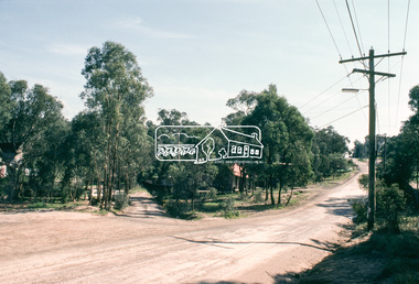
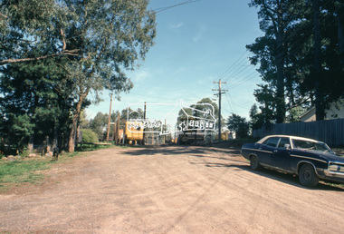
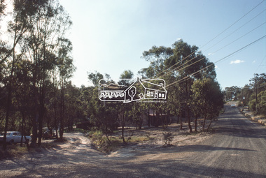
Slide, Quinn Estate, Reichelt Avenue, Montmorency, 15 Sep. 1982
... Quinn Estate, Reichelt Avenue, Montmorency...They provide perspective of the changes in housing styles and road development that began sweeping in from the mid 1970s with increasing urbanisation of what was once more outlying suburbs and regions. housing estate infrastructure montmorency quinn estate roads private street scheme McCarthy Grove Reichelt Avenue Processed 15 Sep1980 35 mm colour positive transparency (1 of15) Mount - Kodak Kodachrome Card Quinn Estate, Reichelt Avenue, Montmorency Slide Slide ...One of a series of images of roads and infrastructure taken by Eltham Shire Council Planning and Engineering officers of the Quinn Estate in Montmorency, Stage 1, Private Street Scheme during construction, September 1982. They provide perspective of the changes in housing styles and road development that began sweeping in from the mid 1970s with increasing urbanisation of what was once more outlying suburbs and regions.35 mm colour positive transparency (1 of15) Mount - Kodak Kodachrome CardProcessed 15 Sep1980housing estate, infrastructure, montmorency, quinn estate, roads, private street scheme, mccarthy grove, reichelt avenue -
 Eltham District Historical Society Inc
Slide, Quinn Estate, Reichelt Avenue, Montmorency, 15 Sep. 1982
... Quinn Estate, Reichelt Avenue, Montmorency...They provide perspective of the changes in housing styles and road development that began sweeping in from the mid 1970s with increasing urbanisation of what was once more outlying suburbs and regions. housing estate infrastructure montmorency quinn estate roads private street scheme reichelt avenue Processed 15 Sep1980 35 mm colour positive transparency (1 of15) Mount - Kodak Kodachrome Card Quinn Estate, Reichelt Avenue, Montmorency Slide Slide ...One of a series of images of roads and infrastructure taken by Eltham Shire Council Planning and Engineering officers of the Quinn Estate in Montmorency, Stage 1, Private Street Scheme during construction, September 1982. They provide perspective of the changes in housing styles and road development that began sweeping in from the mid 1970s with increasing urbanisation of what was once more outlying suburbs and regions.35 mm colour positive transparency (1 of15) Mount - Kodak Kodachrome CardProcessed 15 Sep1980housing estate, infrastructure, montmorency, quinn estate, roads, private street scheme, reichelt avenue -
 Eltham District Historical Society Inc
Slide, Quinn Estate, Reichelt Avenue, Montmorency, 15 Sep. 1982
... Quinn Estate, Reichelt Avenue, Montmorency...They provide perspective of the changes in housing styles and road development that began sweeping in from the mid 1970s with increasing urbanisation of what was once more outlying suburbs and regions. housing estate infrastructure montmorency quinn estate roads private street scheme Footpaths and gutters Reichelt Avenue Processed 15 Sep1980 35 mm colour positive transparency (1 of15) Mount - Kodak Kodachrome Card Quinn Estate, Reichelt Avenue, Montmorency Slide Slide ...One of a series of images of roads and infrastructure taken by Eltham Shire Council Planning and Engineering officers of the Quinn Estate in Montmorency, Stage 1, Private Street Scheme during construction, September 1982. They provide perspective of the changes in housing styles and road development that began sweeping in from the mid 1970s with increasing urbanisation of what was once more outlying suburbs and regions.35 mm colour positive transparency (1 of15) Mount - Kodak Kodachrome CardProcessed 15 Sep1980housing estate, infrastructure, montmorency, quinn estate, roads, private street scheme, footpaths and gutters, reichelt avenue -
 Eltham District Historical Society Inc
Slide, Quinn Estate, Reichelt Avenue, Montmorency, 15 Sep. 1982
... Quinn Estate, Reichelt Avenue, Montmorency...They provide perspective of the changes in housing styles and road development that began sweeping in from the mid 1970s with increasing urbanisation of what was once more outlying suburbs and regions. housing estate infrastructure montmorency quinn estate roads private street scheme reichelt avenue Processed 15 Sep1980 35 mm colour positive transparency (1 of15) Mount - Kodak Kodachrome Card Quinn Estate, Reichelt Avenue, Montmorency Slide Slide ...One of a series of images of roads and infrastructure taken by Eltham Shire Council Planning and Engineering officers of the Quinn Estate in Montmorency, Stage 1, Private Street Scheme during construction, September 1982. They provide perspective of the changes in housing styles and road development that began sweeping in from the mid 1970s with increasing urbanisation of what was once more outlying suburbs and regions.35 mm colour positive transparency (1 of15) Mount - Kodak Kodachrome CardProcessed 15 Sep1980housing estate, infrastructure, montmorency, quinn estate, roads, private street scheme, reichelt avenue -
 Eltham District Historical Society Inc
Slide, Quinn Estate, Reichelt Avenue, Montmorency, 15 Sep. 1982
... Quinn Estate, Reichelt Avenue, Montmorency...They provide perspective of the changes in housing styles and road development that began sweeping in from the mid 1970s with increasing urbanisation of what was once more outlying suburbs and regions. housing estate infrastructure montmorency quinn estate roads private street scheme Reichelt Avenue Processed 15 Sep1980 35 mm colour positive transparency (1 of15) Mount - Kodak Kodachrome Card Quinn Estate, Reichelt Avenue, Montmorency Slide Slide ...One of a series of images of roads and infrastructure taken by Eltham Shire Council Planning and Engineering officers of the Quinn Estate in Montmorency, Stage 1, Private Street Scheme during construction, September 1982. They provide perspective of the changes in housing styles and road development that began sweeping in from the mid 1970s with increasing urbanisation of what was once more outlying suburbs and regions.35 mm colour positive transparency (1 of15) Mount - Kodak Kodachrome CardProcessed 15 Sep1980housing estate, infrastructure, montmorency, quinn estate, roads, private street scheme, reichelt avenue -
 Eltham District Historical Society Inc
Slide, Quinn Estate, Reichelt Avenue, Montmorency, 15 Sep. 1982
... Quinn Estate, Reichelt Avenue, Montmorency...They provide perspective of the changes in housing styles and road development that began sweeping in from the mid 1970s with increasing urbanisation of what was once more outlying suburbs and regions. housing estate infrastructure montmorency quinn estate roads private street scheme reichelt avenue Processed 15 Sep1980 35 mm colour positive transparency (1 of15) Mount - Kodak Kodachrome Card Quinn Estate, Reichelt Avenue, Montmorency Slide Slide ...One of a series of images of roads and infrastructure taken by Eltham Shire Council Planning and Engineering officers of the Quinn Estate in Montmorency, Stage 1, Private Street Scheme during construction, September 1982. They provide perspective of the changes in housing styles and road development that began sweeping in from the mid 1970s with increasing urbanisation of what was once more outlying suburbs and regions.35 mm colour positive transparency (1 of15) Mount - Kodak Kodachrome CardProcessed 15 Sep1980housing estate, infrastructure, montmorency, quinn estate, roads, private street scheme, reichelt avenue -
 Eltham District Historical Society Inc
Slide, Quinn Estate, Reichelt Avenue, Montmorency, 15 Sep. 1982
... Quinn Estate, Reichelt Avenue, Montmorency...They provide perspective of the changes in housing styles and road development that began sweeping in from the mid 1970s with increasing urbanisation of what was once more outlying suburbs and regions. housing estate infrastructure montmorency quinn estate roads private street scheme reichelt avenue Processed 15 Sep1980 35 mm colour positive transparency (1 of15) Mount - Kodak Kodachrome Card Quinn Estate, Reichelt Avenue, Montmorency Slide Slide ...One of a series of images of roads and infrastructure taken by Eltham Shire Council Planning and Engineering officers of the Quinn Estate in Montmorency, Stage 1, Private Street Scheme during construction, September 1982. They provide perspective of the changes in housing styles and road development that began sweeping in from the mid 1970s with increasing urbanisation of what was once more outlying suburbs and regions.35 mm colour positive transparency (1 of15) Mount - Kodak Kodachrome CardProcessed 15 Sep1980housing estate, infrastructure, montmorency, quinn estate, roads, private street scheme, reichelt avenue -
 Eltham District Historical Society Inc
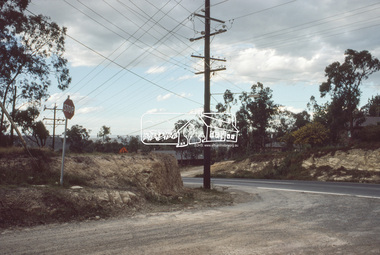
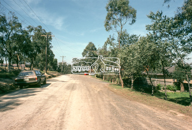
Slide, Roundabout at Reichelt Avenue and McCarthy Grove, Montmorency, c.Oct. 1980
... Roundabout at Reichelt Avenue and McCarthy Grove, Montmorency...Montmorency...Reichelt Avenue...Infrastructure McCarthy grove Montmorency Reichelt Avenue Roads Roundabout Processed Oct 1980 35 mm colour positive transparency Mount - Kodak Kodachrome Card Roundabout at Reichelt Avenue and McCarthy Grove, Montmorency Slide Slide ...One of a series of images of roads and infrastructure focussed on the Quinn Estate in Montmorency taken by Eltham Shire Council Planning and Engineering officers. They provide perspective of the changes in housing styles and road development that began sweeping in from the mid 1970s with increasing urbanisation of what was once more outlying suburbs and regions.35 mm colour positive transparency Mount - Kodak Kodachrome CardProcessed Oct 1980infrastructure, mccarthy grove, montmorency, reichelt avenue, roads, roundabout -
 Eltham District Historical Society Inc
Slide, Quinn Estate, Reichelt Avenue near Riverina Road, Montmorency, c.Oct. 1980
... Quinn Estate, Reichelt Avenue near Riverina Road, Montmorency...Housing estate Infrastructure Montmorency Quinn Estate Reichelt Avenue Roads Processed Oct 1980 35 mm colour positive transparency Mount - Kodak Kodachrome Card Quinn Estate, Reichelt Avenue near Riverina Road, Montmorency Slide Slide ...One of a series of images of roads and infrastructure focussed on the Quinn Estate in Montmorency taken by Eltham Shire Council Planning and Engineering officers. They provide perspective of the changes in housing styles and road development that began sweeping in from the mid 1970s with increasing urbanisation of what was once more outlying suburbs and regions.35 mm colour positive transparency Mount - Kodak Kodachrome CardProcessed Oct 1980housing estate, infrastructure, montmorency, quinn estate, reichelt avenue, roads -
 Greensborough Historical Society
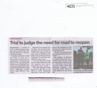
Newspaper Clipping, Diamond Valley Leader, Trial to judge the need for road to reopen, 10/08/2016
... ...reichelt avenue montmorency...Banyule Council will consider reopening an area near Reichelt Avenue and Buena Vista Drive Montmorency...Greensborough Historical Society 34A Glenauburn Road Lower Plenty Lower Plenty melbourne Banyule Council will consider reopening an area near Reichelt Avenue and Buena Vista Drive Montmorency montmorency reichelt avenue montmorency buena vista drive montmornecy News clipping, black text and colour image. ...Banyule Council will consider reopening an area near Reichelt Avenue and Buena Vista Drive MontmorencyNews clipping, black text and colour image.montmorency, reichelt avenue montmorency, buena vista drive montmornecy -
 Eltham District Historical Society Inc
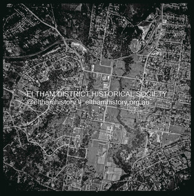
Photograph - Aerial Photograph, Landata, Eltham, Vic, Apr. 1963
... Reichelt Avenue and Rattray Road to west. Historic Aerial Imagery Source: Landata.vic.gov.au Aerial Photo Details: Project No :486 Project : MELBOURNE (1963) PROJECT Run : 6 Frame : 124 Date : 04/1963 Film Type : B/W Camera : RC8 Flying Height : 5100 Scale : 9600 Film Number : 1805 GDA2020 : 37°43'12"S, 145°08'16"E MGA2020 : 335876, 5823604 (55) Melways : 21 G6 (ed. 42) Aerial Photo Neil Webster Collection 1963-04 Bible Street Bolton Street Eltham Eltham Ridge Main Road Montmorency Rattray Road Reichelt Avenue Digital jpg and electronic PDF file Eltham, Vic. ...Centred on present day Eltham Ridge, Bolton Street, Eltham bounded by Elsa Court to north, Main Road to south, Bible Street to east and Reichelt Avenue and Rattray Road to west. Historic Aerial Imagery Source: Landata.vic.gov.au Aerial Photo Details: Project No :486 Project : MELBOURNE (1963) PROJECT Run : 6 Frame : 124 Date : 04/1963 Film Type : B/W Camera : RC8 Flying Height : 5100 Scale : 9600 Film Number : 1805 GDA2020 : 37°43'12"S, 145°08'16"E MGA2020 : 335876, 5823604 (55) Melways : 21 G6 (ed. 42)aerial photo, neil webster collection, 1963-04, bible street, bolton street, eltham, eltham ridge, main road, montmorency, rattray road, reichelt avenue -
 Eltham District Historical Society Inc
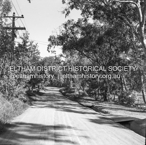
Negative - Photograph, J.A. McDonald, Rattray Road East, Montmorency, 1 May 1961
... McDonald. 1961-05-01 Infrastructure Montmorency Rattray Road Road construction shire of eltham Reichelt Avenue Medium format 120/Kodak 620 6x6 cm black and white negative (1 of 12) contained in Kodak processing envelope with various inscriptions and markings Originally inserted loose with other processing envelopes of negatives and prints within a binder of 78 foolscap pages containing a sequence of photos, adhered via glue or sticky tape, with typed or handwritten headings and captions in pencil, contained in a green foolscap binder with spring clasp spine for retaining loose pages. ...From south boundary lot looking along proposed alignment 1 May 1961Record of various Shire of Eltham infrastructure works undertaken during the period of 1952-1962 involving bridge and road reconstruction projects, sometimes with Eltham Shire Council Project Reference numbers quoted. It was during this period that a number of significant improvements were made to roads and new bridges constructed within the shire that remain in place as of present day (2022). In many situations, the photos provide a tangible visible record of infrastructure that existed throughout the early days of the Shire. The album was put together by or under the direction of the Shire Engineer, J.A. McDonald.1961-05-01, infrastructure, montmorency, rattray road, road construction, shire of eltham, reichelt avenue -
 Eltham District Historical Society Inc
Album - Photograph Album, J.A. McDonald, Bridge and Road Reconstruction Works, Shire of Eltham, 1952-1962
... Jolly Kangaroo Ground Kangaroo Ground-Queenstown Road Kangaroo Ground-St Andrews Road Lilydale Shire Office Long Gully Bridge Long Gully Creek Long Gully Road Long Gully Lower Plenty Bridge Lower Plenty Footbridge Lower Plenty Oval Lower Plenty Road Lower Plenty Main Road Methodist Church Montmorency Mount Pleasant Road New Holland Old Healesville Road Opening Ceremony Oxley Bridge Para Road Paul Creek Bridge Paul Creek Road Paul Krafeznk Pinnacle Lane Plaques Plenty River Trail Plenty River Presbyterian Church Prof Donald Thomson Pryor Street railway crossing Railway Parade Rattray Road Reconstruction works Reichelt Avenue Research (Vic.) ...J.A. McDonald produced this record in the course of his responsibilities as Shire Engineer for Eltham Shire Council.Record of various Shire of Eltham infrastructure works undertaken during the period of 1952-1962 involving bridge and road reconstruction projects, sometimes with Eltham Shire Council Project Reference numbers quoted. It was during this period that a number of significant improvements were made to roads and new bridges constructed within the shire that remain in place as of present day (2022). In many situations, the photos provide a tangible visible record of infrastructure that existed throughout the early days of the Shire. The album was put together by or under the direction of the Shire Engineer, J.A. McDonald.a. gillies, alistair knox park, benchmark studies, bend of islands, blease road, box hill state school, box hill teachers college, box hill tip, bridge construction, bridge street bridge, bridge, brisbane street, brougham steet, bulldozer, cecil street, charis pelling, cherry tree road, city of preston, cr. a. brinkkotter, cr. charis pelling, cranes, cromwell street, diamond creek (creek), diamond street, dixons creek bridge, dixon's creek road, drott, eltham leisure centre, eltham north, eltham police station, eltham, eltham-yarra glen road, f. wood, fitzsimons lane bridge, flat rock road, flood damage, floods, floodwater, footpaths and gutters, ford service garage, g. blair, garden hill, glen park bridge, glenauburn road, grand hotel, haldane road, healesville, healesville-yarra glen road, heidelberg-kinglake road, henley road bridge, henley road, hill property, hurstbridge water scheme, hurstbridge, hurstbridge-arthurs creek road, infrastructure, j. jolly, kangaroo ground, kangaroo ground-queenstown road, kangaroo ground-st andrews road, lilydale shire office, long gully bridge, long gully creek, long gully road, long gully, lower plenty bridge, lower plenty footbridge, lower plenty oval, lower plenty road, lower plenty, main road, methodist church, montmorency, mount pleasant road, new holland, old healesville road, opening ceremony, oxley bridge, para road, paul creek bridge, paul creek road, paul krafeznk, pinnacle lane, plaques, plenty river trail, plenty river, presbyterian church, prof donald thomson, pryor street, railway crossing, railway parade, rattray road, reconstruction works, reichelt avenue, research (vic.), research oval, road construction, rymers corner, shire of eltham, shire of whittlesea, silvan road bridge, silver street bridge, silver street, sir dallas brooks, smedley property, st andrews, steels creek, susan street, tarrawarra, tony carberry, uniting church, upper yarra dam, upper yarra reservoir, w.e. wolf, waterfall property, watsons creek, wattletree road bridge, wattletree road, wattletree road bridge, worlingworth, yarra glen, york street, yow yow creek -
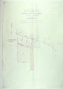
 Eltham District Historical Society Inc
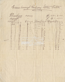
Document - Folder, Greensborough Railway Station Estate, Lots 26, 26A and 26B, Crown Portion 3, Parish of Nillumbik, County of Evelyn (Rattray Road, Montmorency)
... The land detailed is bounded by present-day Rattray Road, Reichelt Avenue, Wooded Way and Ryrie Court, Montmorency. Originally purchased in September 1913 by George William Miller, signwriter of Greensborough and Harry Frederick Miller, the land was sold to Mrs Margaret Barr Honeyman, 24 June 1918 on mortgage for £400, deposit paid £150. ...Contract of sale George William Miller Greensborough Railway Station Estate Harry Frederick Miller Land sale Margaret Barr Honeyman Montmorency Rattray Road Reichelt Avenue Ryrie Court Wooded Way Folder of miscellaneous papers Greensborough Railway Station Estate, Lots 26, 26A and 26B, Crown Portion 3, Parish of Nillumbik, County of Evelyn (Rattray Road, Montmorency) Document Folder ...Crown Portion 3 of Eltham, Parish of Nillumbik, County of Evelyn, Lots 26, 26A and 26B were part of the Greensborough Railway Station Estate. The land detailed is bounded by present-day Rattray Road, Reichelt Avenue, Wooded Way and Ryrie Court, Montmorency. Originally purchased in September 1913 by George William Miller, signwriter of Greensborough and Harry Frederick Miller, the land was sold to Mrs Margaret Barr Honeyman, 24 June 1918 on mortgage for £400, deposit paid £150. In February 1920, Mr Honeyman called for the title and paid off the loan early, settlement occuring 11 October 1920. Contents: 1. Handwritten payment plan (Sep 1913 to Mar 1923) for Lots 26, 26A and 26B being parts of Crown Portion 3, Parish of Nillumbik, County of Evelyn on the plan of subdivision making up the Greensborough Railway Station Estate situated on Rattray Road; purchased for £179.2.0 with a deposit of £18.0.0. 2. Receipt: From Messrs G.W. and H.F. Miller for £11.15.8 being instalment and interest, 9 Sep 1913 3. Invoice: To Messrs G.W. and H.F. Miller for £11.12.0 being instalment and interest due 15 Sep 1914 4. Contract of Sale: George William Miller and Harry Frederick Miller to Mrs. Margaret Barr Honeyman, in respect of sale of Lots 26, 26A and 26B for £400.0.0, 24 June 1918. Deposit of £150.0.0 balance to be paid half yearly instalments of £15 with interest at 5% per annum added. 5. Letter: Percy J. Russell, Solicitor to G.W. Miller, 5 Feb 1920 advising Mr Honeyman has called for the title and wishes to pay off mortgage. 6. Letter: Percy J. Russell, Solicitor to G.W. Miller, 11 Oct 1920 advising settlement and payment of Miller to Honeyman.contract of sale, george william miller, greensborough railway station estate, harry frederick miller, land sale, margaret barr honeyman, montmorency, rattray road, reichelt avenue, ryrie court, wooded way -
 Eltham District Historical Society Inc
Slide - Photograph, Eltham Shire Council, Plan of Subdivision, Part of Crown Portion 3, Parish of Nillumbik, County of Bourke, 1969
... Eltham District Historical Society Inc 728 Main Rd Eltham melbourne Infrastructure Map Montmorency planning Rattray Road Subdivison Lots Reichelt Avenue C5C, Delbridge, 4 lots, Rattray Road, 4 August 1969 35mm colour positive transparency blue Agfacolour Service plastic mount Plan of Subdivision, Part of Crown Portion 3, Parish of Nillumbik, County of Bourke Slide Photograph Eltham Shire Council ...35mm colour positive transparency blue Agfacolour Service plastic mountC5C, Delbridge, 4 lots, Rattray Road, 4 August 1969infrastructure, map, montmorency, planning, rattray road, subdivison lots, reichelt avenue -
 Eltham District Historical Society Inc
Slide, McCarthy Grove, Montmorency looking east towards Reichelt Avenue, near no. 27, c.Oct. 1980
... They provide perspective of the changes in housing styles and road development that began sweeping in from the mid 1970s with increasing urbanisation of what was once more outlying suburbs and regions. houses infrastructure mccarthy grove montmorency roads Processed Oct 1980 35 mm colour positive transparency Mount - Kodak Kodachrome Card McCarthy Grove, Montmorency looking east towards Reichelt Avenue, near no. 27 Slide Slide ...One of a series of images of roads and infrastructure taken by Eltham Shire Council Planning and Engineering officers. They provide perspective of the changes in housing styles and road development that began sweeping in from the mid 1970s with increasing urbanisation of what was once more outlying suburbs and regions.35 mm colour positive transparency Mount - Kodak Kodachrome CardProcessed Oct 1980houses, infrastructure, mccarthy grove, montmorency, roads -
 Eltham District Historical Society Inc
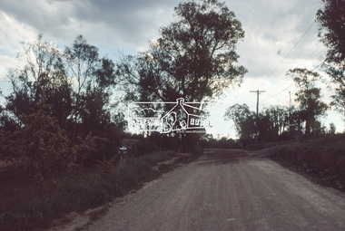
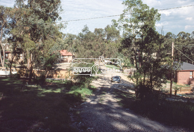
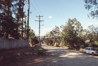
Slide, Reichelt Avenue/Buena Vista Drive closure towards Bolton Street, c.Oct. 1980
... Montmorency...Reichelt Avenue...Buena Vista Drive Infrastructure Montmorency Reichelt Avenue Roads Processed Oct 1980 35 mm colour positive transparency Mount - Kodak Kodachrome Card Reichelt Avenue/Buena Vista Drive closure towards Bolton Street Slide Slide ...One of a series of images of roads and infrastructure focussed on the Quinn Estate in Montmorency taken by Eltham Shire Council Planning and Engineering officers. They provide perspective of the changes in housing styles and road development that began sweeping in from the mid 1970s with increasing urbanisation of what was once more outlying suburbs and regions.35 mm colour positive transparency Mount - Kodak Kodachrome CardProcessed Oct 1980buena vista drive, infrastructure, montmorency, reichelt avenue, roads