Showing 46 items matching "research oval"
-
 Eltham District Historical Society Inc
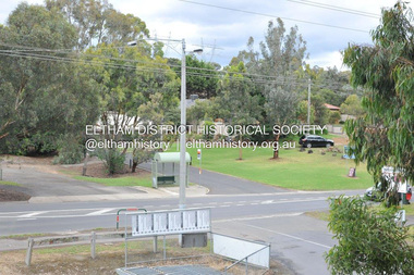
Photograph, Barry Philp, Entrance to Research Oval, Eltham Motor Inn opposite, Main Road, Eltham, c.2013
... Entrance to Research Oval, Eltham Motor Inn opposite, Main Road, Eltham......Research Oval...Eltham Eltham Motor Inn Research Oval Reynolds Road Digital copy only Entrance to Research Oval, Eltham Motor Inn opposite, Main Road, Eltham Photograph Photograph Barry Philp ...Corner of Reynolds Road just out of sight to left. View is comparable to EDHS_05762 showing the site of the original home of the Dodkins family now the Eltham Motor Inn.main road, research (vic.), eltham, eltham motor inn, research oval, reynolds road -
 Eltham District Historical Society Inc
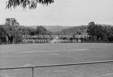
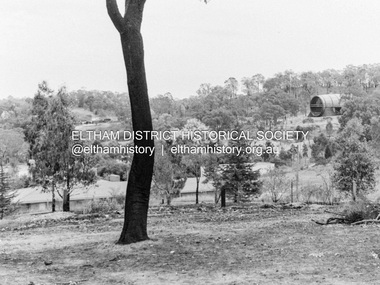
Photograph, Barry Philp, View towards Eltham from Research Oval, c.1969
... View towards Eltham from Research Oval......Research Oval...Eltham District Historical Society Inc 728 Main Rd Eltham melbourne Taken from Cricket Club oval, looking down the Hill towards Eltham Research (Vic.) Eltham Main Road Research Cricket Club Research Oval Digital copy only View towards Eltham from Research Oval Photograph Photograph Barry Philp ...Taken from Cricket Club oval, looking down the Hill towards Elthamresearch (vic.), eltham, main road, research cricket club, research oval -
 Eltham District Historical Society Inc
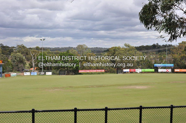
Photograph, Barry Philp, View towards Eltham from Research Oval, c.2013
... View towards Eltham from Research Oval......Research Oval...Eltham District Historical Society Inc 728 Main Rd Eltham melbourne Taken from Cricket Club oval, looking down the Hill towards Eltham Research (Vic.) Eltham Main Road Research Cricket Club Research Oval Digital copy only View towards Eltham from Research Oval Photograph Photograph Barry Philp ...Taken from Cricket Club oval, looking down the Hill towards Elthamresearch (vic.), eltham, main road, research cricket club, research oval -
 Eltham District Historical Society Inc
Negative - Photograph, J.A. McDonald, Reconstruction works, Research Oval, Jan. 1961
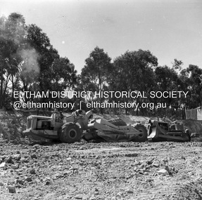
... Reconstruction works, Research Oval......Research Oval...Reconstruction works, Research Oval Negative Photograph J.A. McDonald ...Looking north Early January 1961Record of various Shire of Eltham infrastructure works undertaken during the period of 1952-1962 involving bridge and road reconstruction projects, sometimes with Eltham Shire Council Project Reference numbers quoted. It was during this period that a number of significant improvements were made to roads and new bridges constructed within the shire that remain in place as of present day (2022). In many situations, the photos provide a tangible visible record of infrastructure that existed throughout the early days of the Shire. The album was put together by or under the direction of the Shire Engineer, J.A. McDonald.shire of eltham, 1961-01, infrastructure, reconstruction works, research (vic.), research oval -
 Eltham District Historical Society Inc
Negative - Photograph, J.A. McDonald, Reconstruction works, Research Oval, Jan. 1961
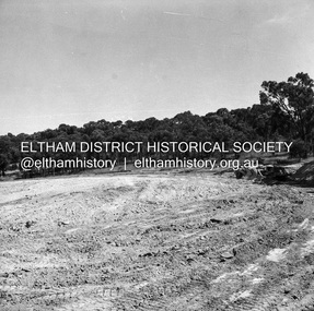
... Reconstruction works, Research Oval......Research Oval...Reconstruction works, Research Oval Negative Photograph J.A. McDonald ...Looking southeast Late January 1961Record of various Shire of Eltham infrastructure works undertaken during the period of 1952-1962 involving bridge and road reconstruction projects, sometimes with Eltham Shire Council Project Reference numbers quoted. It was during this period that a number of significant improvements were made to roads and new bridges constructed within the shire that remain in place as of present day (2022). In many situations, the photos provide a tangible visible record of infrastructure that existed throughout the early days of the Shire. The album was put together by or under the direction of the Shire Engineer, J.A. McDonald.shire of eltham, 1961-01, infrastructure, reconstruction works, research (vic.), research oval -
 Eltham District Historical Society Inc
Negative - Photograph, J.A. McDonald, Reconstruction works, Research Oval, Jan. 1961
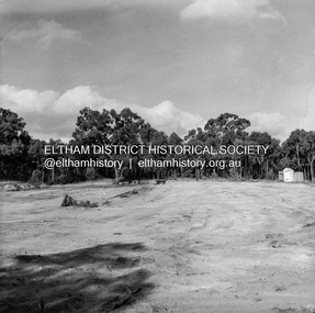
... Reconstruction works, Research Oval......Research Oval...Reconstruction works, Research Oval Negative Photograph J.A. McDonald ...Looking north at end of reconstruction Late January 1961Record of various Shire of Eltham infrastructure works undertaken during the period of 1952-1962 involving bridge and road reconstruction projects, sometimes with Eltham Shire Council Project Reference numbers quoted. It was during this period that a number of significant improvements were made to roads and new bridges constructed within the shire that remain in place as of present day (2022). In many situations, the photos provide a tangible visible record of infrastructure that existed throughout the early days of the Shire. The album was put together by or under the direction of the Shire Engineer, J.A. McDonald.shire of eltham, 1961-01, infrastructure, reconstruction works, research (vic.), research oval -
 Eltham District Historical Society Inc
Negative - Photograph, J.A. McDonald, Reconstruction works, Research Oval, Jan. 1961
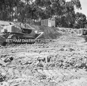
... Reconstruction works, Research Oval......Research Oval...Reconstruction works, Research Oval Negative Photograph J.A. McDonald ...At commencement, looking east Early January 1961Record of various Shire of Eltham infrastructure works undertaken during the period of 1952-1962 involving bridge and road reconstruction projects, sometimes with Eltham Shire Council Project Reference numbers quoted. It was during this period that a number of significant improvements were made to roads and new bridges constructed within the shire that remain in place as of present day (2022). In many situations, the photos provide a tangible visible record of infrastructure that existed throughout the early days of the Shire. The album was put together by or under the direction of the Shire Engineer, J.A. McDonald.shire of eltham, 1961-01, infrastructure, reconstruction works, research (vic.), research oval -
 Eltham District Historical Society Inc
Photograph, Barry Philp, Eltham Barrel, c.1969
... ...Research Oval...View looking from inside the fence below Research Oval. Believed to have been taken shortly after the 1968-69 Bushfire. ...Eltham Barrel Research Oval Digital copy only Eltham Barrel Photograph Photograph Barry Philp ...View looking from inside the fence below Research Oval. Believed to have been taken shortly after the 1968-69 Bushfire. The Eltham Barrel weas completed in 1968.research (vic.), eltham barrel, research oval -
 Eltham District Historical Society Inc
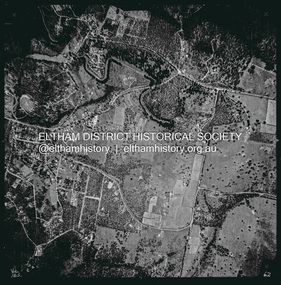
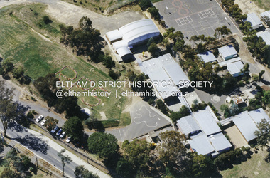
Photograph - Aerial Photograph, Landata, Research, Vic, Apr. 1963
... ...Research Oval...Centred on present day Marconi Court, Research bounded by Maroondah Aqueduct to north, Thompson Crescent to south, Joselyn Drive to east and Eltham Research Oval to west. Historic Aerial Imagery Source: Landata.vic.gov.au Aerial Photo Details: Project No :486 Project : MELBOURNE (1963) PROJECT Run : 5 Frame : 62 Date : 04/1963 Film Type : B/W Camera : RC8 Flying Height : 5100 Scale : 9600 Film Number : 1805 GDA2020 : 37°42'24"S, 145°10'43"E MGA2020 : 339434, 5825157 (55) Melways : 22 F3 (ed. 42)...Research Oval Thompson Crescent Digital jpg and electronic PDF file Research, Vic. ...Centred on present day Marconi Court, Research bounded by Maroondah Aqueduct to north, Thompson Crescent to south, Joselyn Drive to east and Eltham Research Oval to west. Historic Aerial Imagery Source: Landata.vic.gov.au Aerial Photo Details: Project No :486 Project : MELBOURNE (1963) PROJECT Run : 5 Frame : 62 Date : 04/1963 Film Type : B/W Camera : RC8 Flying Height : 5100 Scale : 9600 Film Number : 1805 GDA2020 : 37°42'24"S, 145°10'43"E MGA2020 : 339434, 5825157 (55) Melways : 22 F3 (ed. 42)aerial photo, neil webster collection, 1963-04, joselyn drive, marconi court, melway 22f3, research (vic.), research oval, thompson crescent -
 Eltham District Historical Society Inc
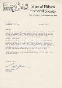
Document - Folder, Eltham Community Festival, 1986
... ...Research Oval...Firewaorks brilliant, Diamond Valley News, Tuesday, November 11, 1986, p12 1986 ben hall eltham festival eltham town park parade phyllis macdonald russell yeoman 11 Bridge Street Eltham Advertising Banner Project Eltham Clubs Eltham Combined Service Clubs Eltham Community Centre Eltham Community Festival eltham hotel Eltham Police eltham pre-school Lions Club Eltham Pine Connection Plenty Valley Montessori School Research Football Club Research Oval Research Pre-school Research primary school Research Scout Group Sgt Arthur Traynor Shire of Eltham Banner Project Shire of Eltham Historical Society 953 Main Road Eltham Wattle Studios Letter A4 x 2 Eltham Community Festival Document Folder ...1. Letter from the Secretary of Shire of Eltham Historical Society to Ben Hall of Tullamarine, 11 August 1986 - Enquiry (11 Aug 1986) as to whether Ben Hall would be interested in partnering with the Society in the 1986 Eltham Festival (8-9 November) to participate in the parade and then offer rides after the parade to recover costs of entry. 2. Copy of letter (8 Apr 1987) offering payment in recognition of Ben Hall's efforts for the parade in 1986 3. Eltham's festival celebrates International Year of Peace, Diamond Valley News, Tuesday, October 14, 1986 (on reverse, advertising for opening of The Photo Centre at Shop 11, Eltham Mall, Arthur Street) 4. Firewaorks brilliant, Diamond Valley News, Tuesday, November 11, 1986, p12Letter A4 x 21986, ben hall, eltham festival, eltham town park, parade, phyllis macdonald, russell yeoman, 11 bridge street eltham, advertising, banner project, eltham clubs, eltham combined service clubs, eltham community centre, eltham community festival, eltham hotel, eltham police, eltham pre-school, lions club eltham, pine connection, plenty valley montessori school, research football club, research oval, research pre-school, research primary school, research scout group, sgt arthur traynor, shire of eltham banner project, shire of eltham historical society, 953 main road eltham, wattle studios -
 Eltham District Historical Society Inc
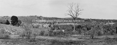
Photograph, Barry Philp, Looking north from the top of the hill near Reynolds Road, Research, c.1969
... ...Research Oval...Research (Vic.) Research Oval Reynolds Road Digital copy only - panorama created from two digital scans Looking north from the top of the hill near Reynolds Road, Research. ...Taken from the top of the hill near Reynolds road looking north. The footy ground is visible behind the dead tree.research (vic.), research oval, reynolds road -
 Eltham District Historical Society Inc
Album - Photograph Album, J.A. McDonald, Bridge and Road Reconstruction Works, Shire of Eltham, 1952-1962
... ...Research Oval...Research Oval Road construction Rymers Corner shire of eltham Shire of Whittlesea Silvan Road Bridge Silver Street Bridge silver street Sir Dallas Brooks Smedley property St Andrews Steels Creek Susan Street tarrawarra Tony Carberry Uniting Church Upper Yarra Dam Upper Yarra Reservoir W.E. ...J.A. McDonald produced this record in the course of his responsibilities as Shire Engineer for Eltham Shire Council.Record of various Shire of Eltham infrastructure works undertaken during the period of 1952-1962 involving bridge and road reconstruction projects, sometimes with Eltham Shire Council Project Reference numbers quoted. It was during this period that a number of significant improvements were made to roads and new bridges constructed within the shire that remain in place as of present day (2022). In many situations, the photos provide a tangible visible record of infrastructure that existed throughout the early days of the Shire. The album was put together by or under the direction of the Shire Engineer, J.A. McDonald.a. gillies, alistair knox park, benchmark studies, bend of islands, blease road, box hill state school, box hill teachers college, box hill tip, bridge construction, bridge street bridge, bridge, brisbane street, brougham steet, bulldozer, cecil street, charis pelling, cherry tree road, city of preston, cr. a. brinkkotter, cr. charis pelling, cranes, cromwell street, diamond creek (creek), diamond street, dixons creek bridge, dixon's creek road, drott, eltham leisure centre, eltham north, eltham police station, eltham, eltham-yarra glen road, f. wood, fitzsimons lane bridge, flat rock road, flood damage, floods, floodwater, footpaths and gutters, ford service garage, g. blair, garden hill, glen park bridge, glenauburn road, grand hotel, haldane road, healesville, healesville-yarra glen road, heidelberg-kinglake road, henley road bridge, henley road, hill property, hurstbridge water scheme, hurstbridge, hurstbridge-arthurs creek road, infrastructure, j. jolly, kangaroo ground, kangaroo ground-queenstown road, kangaroo ground-st andrews road, lilydale shire office, long gully bridge, long gully creek, long gully road, long gully, lower plenty bridge, lower plenty footbridge, lower plenty oval, lower plenty road, lower plenty, main road, methodist church, montmorency, mount pleasant road, new holland, old healesville road, opening ceremony, oxley bridge, para road, paul creek bridge, paul creek road, paul krafeznk, pinnacle lane, plaques, plenty river trail, plenty river, presbyterian church, prof donald thomson, pryor street, railway crossing, railway parade, rattray road, reconstruction works, reichelt avenue, research (vic.), research oval, road construction, rymers corner, shire of eltham, shire of whittlesea, silvan road bridge, silver street bridge, silver street, sir dallas brooks, smedley property, st andrews, steels creek, susan street, tarrawarra, tony carberry, uniting church, upper yarra dam, upper yarra reservoir, w.e. wolf, waterfall property, watsons creek, wattletree road bridge, wattletree road, wattletree road bridge, worlingworth, yarra glen, york street, yow yow creek -
 Eltham District Historical Society Inc
Document - Archive Box, 1570 Main Road, Research (Research Primary School)
... This land surrounded the school site and includes today’s [1989] Kanandah Ct, Raglan St and shops” • Black and white photo print, 20 x 25 cm, Reconstruction of Main Road in front of Research Primary School, August 1989 • Black and white photo print, 20 x 25 cm, Eastern end of old oval, Research Primary School, 1989 • Black and white photo print, 20 x 25 cm, Portable Buildings, Research Primary School, 1989 • Black and white photo print, 20 x 25 cm, Gymnasium, Research Primary School, 1989 • Black and white photo print, 20 x 25 cm, Administrative Art Building, Research Primary School, c.1989 • Black and white photo print, 20 x 25 cm, Betty Kicker, Cleaner at Research Primary School, c.1989. ...This land surrounded the school site and includes today’s [1989] Kanandah Ct, Raglan St and shops” • Black and white photo print, 20 x 25 cm, Reconstruction of Main Road in front of Research Primary School, August 1989 • Black and white photo print, 20 x 25 cm, Eastern end of old oval, Research Primary School, 1989 • Black and white photo print, 20 x 25 cm, Portable Buildings, Research Primary School, 1989 • Black and white photo print, 20 x 25 cm, Gymnasium, Research Primary School, 1989 • Black and white photo print, 20 x 25 cm, Administrative Art Building, Research Primary School, c.1989 • Black and white photo print, 20 x 25 cm, Betty Kicker, Cleaner at Research Primary School, c.1989. ...Contents: 1. Andrew Lemon's Working File of Return to Research Andrew Lemon's Working File for his 1989 book, “Return to Research: A Centenary History of Research Primary School" (EDHS_00867). Includes a disassembled copy of the book. (All other documentation and photos passed to Research Primary School 3 September 2013) 1.1. EDHS_05004 - Cassette Tape of "Afternoon Tea with Senior Residents Nov 1st 1984" Reminiscences, chit chat and banter between group of senior citizens at an afternoon tea held for them at Research Primary School. 1.2. School Register 1935-1994 (Box 1) Photocopy of Research Primary School register from 1935 to 1994 (originals held at school) From 1994 onwards registrations were made online via the Education Department CASES system. 1.3. School Register A-Z 1935-1987 (Box 2) Computer print-out of alphabetized register 1935-87 (Research Primary School) (Done by David and Sue Grigg in 1987 from the register) Contains some extra details/corrections/current addresses Plus disks containing this data (not housed in box – there is a separate floppy disc box containing several 5 ¾” and 3 ½” floppy disks which are not readable as no hardware/software to support) 1.4. Research Locality History (Yellow Folder 1) Research Locality History Newspaper cuttings, Photocopies etc Collection for Research Primary School History 1989 Contents • 3 x photocopies (A3) regarding sale of Raglan Estate, Research [2 x A3 and 1 x composite A3 colour photocopy] • Souvenir Map of area with pictures of historical items and wild life - A Visitor's Guide Map; ELTHAM, WARRANDYTE and Environs (see also EDHS_01633-1) • EO article 26 Mar 1897 "Research State School picnic expedition to Mordialloc" • TA article 25 Jul 30" Research Affairs" plus an add for J Ingram's Research Bakery • DVN articles 14 Jan 69 (2 pages) "Research Fire Victim (Bill Pelling) still in hospital" • DVN 14 Jan 69 Page of Deaths, In Memories, Obituaries, Church Notices, Public Notices and Notices • Age article 24 Jan 84 "Eltham before the Mud Bricks" • DVN article 21 Oct 86 "Facing Good and Bad Times with enthusiasm - Keith Maxwell" • DVN article 29 Aug 87 "Eltham - the historic haven" • DVN article 25 Aug 87 "Eltham - a piece of living history, (the historic haven cont…)" • DVN article 20 Oct 87 "When push bikes were made for touring - Sam Howard" • 6 x pages of what appear to be various student's workbooks/ projects from 1944/45 era • ''They lost their homes- Historical places go at Research" plus other articles on fires 8 Jan 69 [Located in Folder 2] • DVN articles 23 Oct 84 "Centenary Plans" & Folklore surrounds Research township" [Located in Folder 2] • DVN article 23 Sep 86 "The teacher who had cut cane but never used one" Frank Sheehan (3 copies) [Located in Folder 2] • 2 x copies of booklet "Memories of Eltham" [Located in Folder 3] • Photocopy of subdivision Parish of Nillumbik [Located in Folder 4] DVN = Diamond Valley News, EO = Evelyn Observer TA= The Advertiser 1.5. Copies of items held by Public Records Office Victoria (Yellow Folder 2) Copies of items held by Public Records Office Photos and display items from Research Primary School Centenary August 19, 1989 • Laminated photocopy: “State School No. 2959, Copy of the above school property,” signed Henry L. Cole 18.6.91 • Photocopy: Petition for a school at Research, 13/11/1888; Public Record Office Victoria School Building File – School 2959 CUPRS 795/1717 • Photocopy: Negotiation to buy school site – part of Allotment 2, owned by the West family (copy attached to letter) 15/1/1890; Public Record Office Victoria School Building File – School 2959 CUPRS 795/1717 • Photocopy: Frank Scott, Head Teacher Research 1904-1907, letter of explanation (first page) to Department re poor results by pupils at the school, 24/8/1907; Public Record Office Victoria School Building File – 640 / School 2959 • Photocopy: Anton Brinkkotter’s Certificate for Regular Attendance 1908 (This was ‘traded in’ in 1911 for a certificate to mark six years without missing a day of school; Public Record Office Victoria School Building File – 640 / School 2959 for 1911 • Photocopy: Education Department Memorandum 1949 re need for extensions and improvements; Public Record Office Victoria School Building File – 795 / School 2959 • Photocopy: Looking to the future about expanding site for additional land for play space, 1950, Education Department Inspector to Department; Public Record Office Victoria School Building File – 795 / School 2959 • Photocopy (laminated, 2 sheets) First School Fire -1953 copy of Police Report. The old school building was badly damaged but repaired. It burnt down in 1976; Public Record Office Victoria School Building File – 795 / School 2959 • Photocopy: The Argus (28 July 1953) & the (Sun 28 July 1953) Two newspaper cuttings and notes re school fire 1953; Public Record Office Victoria School Building File – / School 2959 • Photocopy: Head Teacher Reg Jackman expresses concern to Education Department about conditions as he takes charge of Research State School, 1957; Public Record Office Victoria School Building File – 640 / School 2959 • Photo print (x2) of Education Department Qualifications and Certificates, Lyla Dickson, State School. (1) Print missing (2) Education department Victoria, Merit Certificate, This is to certify that Lyla Dickson has completed satisfactorily the Course of Study presented for the Eight Grade in Elementary Schools, dated at research Elementary School, this 20th day of November A.D. 1923 • Copy of original photo owned by Nell Howard “Fancy dress night in the school house – 1920s”, black and white print, 10.5 x 18 cm, attached to A4 photocopy of photo with names inscribed10.5 x 18 cm • Copy of original photo (stamped Reynolds Collection), black and white print, 24.5 x 16 cm, attached to paper sheet 37.6 x 25.5 cm, inscribed “Miss Doney” and “Elizabeth Doney and her family owned and ran Research’s Store and Post Office for many years after buying the property from the wests. This land surrounded the school site and includes today’s [1989] Kanandah Ct, Raglan St and shops” • Black and white photo print, 20 x 25 cm, Reconstruction of Main Road in front of Research Primary School, August 1989 • Black and white photo print, 20 x 25 cm, Eastern end of old oval, Research Primary School, 1989 • Black and white photo print, 20 x 25 cm, Portable Buildings, Research Primary School, 1989 • Black and white photo print, 20 x 25 cm, Gymnasium, Research Primary School, 1989 • Black and white photo print, 20 x 25 cm, Administrative Art Building, Research Primary School, c.1989 • Black and white photo print, 20 x 25 cm, Betty Kicker, Cleaner at Research Primary School, c.1989. Betty worked at the school from early 1970s to 1990s 1.6. ‘Memories of Research 1951-1968’ (Yellow Folder 3) Interview by Sue Grigg of Florence Egglestone for publication in Return to Research. Original handwritten notes, ‘Memories of Research 1951-1968’ 1.7. Centenary Committee Minutes & Newsletters (Yellow Folder 4) Centenary Committee Minutes and Newsletters Information regarding attendance of 100th anniversary including lists of staff contact details 1983-1986 Request (1985) to Shire of Eltham Historical Society for information and memorabilia • Letter: Ann Bouchier, Convenor – Centenary Committee, Research Primary School to R. Yeoman, Shire of Eltham Historical Society, 15 October 1985; enquiring about memorabilia etc that could be used in a proposed compilation on the “History of the School.” • Minutes of Meeting, Centenary Sub-Committee, Research Primary School Council o 17 June 1985. Also includes a list of general aim, specific aims and methods for the research Primary School Centenary - 1989 o 15 October 1985. o 17 September 1986. o 20 August 1987. o 2 May 1988. o 9 June 1988. o 22 August 1988. o 12 October 1988. o 24 November 1988. o 17 April 1989. o 24 July 1989. • Outline of Historical Events 1884-1954 (3 pages) • Centenary Newsletters o Number 1 (1989) o Number 2 (1989) o Number 3 (1989) o Newsletter (c. Aug. 1989) • Information re attendance of 100th Anniversary, Research Primary School, 19 August 1989 o Research Primary School – Staff 1984 (includes Name, Address, Telephone) o Research Primary School – Staff 1985 (includes Name, Address, Telephone) o Research Primary School – Staff 1986 (includes Name, Address, Telephone) o Emergency Teacher List 1983 o Emergency Teacher List 1986 o Previous teachers 1984 on • Quotation No. 733, Major Graphics for Engraved Brass Commemorative Plaque for opening of School Gymnasium • Centenary Invitation; Program and Souvenir and Chicken & Champagne Supper order forms • Various Centenary Invitation lists with notations, and various returned RSVPs • Centenary Program and map • Photocopy: 11 pages typed with hand corrections, draft manuscript for Andrew Lemon’s book, Return to Research (pages 13-24) • Bulletin: “I’m an Aussie” Week – 15th-19th April 10/4/85 • Bulletin: Research Centenary 26/4/88 • Bulletin: Official Centenary Logo For Research Primary School 15/12/88 • Bulletin: Centenary School Activity – “Colonial School” 23/5/89 • Bulletin: Centenary Activity Days – Monday, 14th August, Tuesday, 15th August 7/8/89 • Advertisement: A3 photocopy, Centenary Bush Dance, Sat. 4th March featuring “Paradiddle” Bush Band • Photocopy Master: Invitation (blank) to attend “Return to Research” celebration and Official Opening of the School Gymnasium on Saturday, August 19th from 1.00p.m. to 5.00p.m. and attached RSVP (also includes yellow paper sample -blank) • Photocopy Master: Tickets for Centenary Chicken & Champagne Supper, Friday, 18th August 1989, 7.30p.m., $5.00 per head (2 yellow paper samples marked on reverse ‘13’ and ‘55’) • Photocopy Master: Centenary Gift Donated by slips including multiple blank samples • Promotional Notices o Letter, Robert Wenn, Principal, 29 November 1988 for placement of “HELP WANTED” in Public Notices of The Age o Information provided to Ian Reid Real Estate Agent for Board to promote Centenary Bush Dance Paradiddle Band, Saturday 4 March 1989 o Notice Board promoting ‘Old Time’ Gala Fete Saturday 17 June 1989 o Letter, Robert Wenn, Principal, 24 August 1989 to Ian Reid Real Estate thanking for support of Centenary celebration and successful book launch and seeking further support for next event being school musical production “Spirit of Research” written by Andrew Lemon to be performed December 7th. 1.8. 1989 Research Primary School Centenary Visitors Register and Sue Grigg Correspondence (Red Folder) Sue Grigg’s Folder of Visitors to 1989 Centenary Celebrations and correspondence to Sue Grigg as organiser of Centenary Celebrations • 22 A3 Sheets of 1989 Research Primary School Centenary Visitors Register (approx. 238 entries) • Correspondence to Sue Grigg as Organizer of Centenary Celebrations o Trace B? – Ingram, Dunolly, 30 January 1990 re photo of Ingrams Road. Includes hand drawn map of various buildings on Ingrams Road. Also black and white print copy (12.5 x 17.5 cm) of photo of Ingrams and Main Road (possibly one sent to her) – see SEPP_0511 o Barbara Booth (nee Coles); thanks for wonderful celebration o Len and Marlene Parsons, 21 August 1989 o Mrs R. Towers, n.d. thanks for school photo ordered o Winifred L. Lade, 7 August 1989, gg grandparents William and Mary Crozier, daughter Sarah married Thomas Baillie (her g grandparents). Thomas Baillie was one of the petitioners for the school o Winifred L. Lade, n.d., thanks for photo and map o Carol Mathews, thanks for celebrations and payments for photos. Written on reverse of Sue Grigg’s letter to her of 19 September 1989 o Kenneth Ingram, Monday 14th, thanks for invitation but unable to attend • Photo of Ingrams and Main Road 1.9. Student Photos c.1970s (Buff Folder 1) [Not in Archive Box] Quantity of photos of students taken by Mrs Avril Baker (Staff Member) In 1970s 1.10. 1989 Centenary Questionnaires (Buff Folder 2) Research Primary School, 1989 Centenary Questionnaires from school families (approx. 190 responses) 1.11. Archive and Class Photos 1890s-1961 (Buff Folder 3) • Archive photographs of Research and District; 10 x 15 cm prints and digital files on thumb drive (copied to Collection catalogue) o RPS 1- Henry Cole Head Teacher 1891 to 1903. Photo from Mrs E. Williams o RPS 2 - Mary Jane Cole with eldest daughter Doris c 1905 o RPS 3 - Wedding Photo Mary Jane Rodda and Henry Cole o RPS 4 - Joseph Rodda of Chun Grove, Research o RPS 5 - Walter Rodda 1917 son of Joseph Rodda o RPS 6- Henry Cole and Pupils 1897 (Reynolds Collection) o RPS 7 - Elizabeth Doney (Reynolds Collections) o RPS 8 - Doney's Store early 1960's o RPS 9 - Main Road Research to Left, lngrams Road to Right o RPS 10- Main Road Eltham from Griggs family o RPS 11- Eltham near Station from Griggs family o RPS 12 - The Main Street Eltham from Griggs family (Rose Series 4344) o RPS 13 - The Rev and Mrs Thomas Cole. Parents of Henry Cole o RPS 14- Henry Cole as a boy with older brother Tom. From Mrs E. Williams. o RPS 15- Mary Jane Rodda as Mrs Henry Cole, Sewing Mistress Research State School 1891 to 1897 o RPS 16 - Etta Rodda Sewing Mistress Research State School 1897 -1904 o RPS 17 - Frederick Rodda son of Joseph Rodda o RPS 18- Bush Fires 1963 o RPS 19 - The view to the northeast from the top of the School Grounds 1989 o RPS 20- Edwin Rodda son of Joseph Rodda • Class and Staff photos, some with lists and names for identification [see separate folder of digital files – no hard copies in folder] Decade Years Represented 1890-1899 1897 1900-1909 1900, 1904 1910-1919 1910 1920-1929 1922, 1925 1930-1939 1930, 1932, 1937 1940-1949 1940, 1942 1950-1959 1950, 1951, 1952, 1953, 1954, 1955, 1956, 1957, 1958 1960-1969 1960, 1961, 1969 1970-1979 1970, 1971, 1972, 1973, 1975, 1976, 1977, 1978, 1979 Staff: 1971, 1976, 1978, 1979 1980-1989 1980, 1981, 1982, 1983, 1984, 1985, 1986, 1987, 1988, 1989 Staff: 1981, 1982, 1985, 1986, 1987, 1988, 1989 1990-1999 1990, 1991, 1994, 1995, 1996, 1997, 1998, 1999 Staff: 1990, 1994, 1995, 1996, 1998, 1999 2000-2009 2000, 2001, 2002, 2003, 2004, 2005, 2006, 2007, 2008, 2009 Staff: 2000, 2002, 2003, 2004, 2005, 2006, 2007, 2008, 2009 2010-2019 2010, 2011, 2012, 2013, 2014 Staff: 2010, 2011, 2012, 2013, 2014 • Class names; 4 pages handwritten and 2 numbered diagrams of Class names: o 1942 whole school o 1975 Grade 1 o 1976 Grade 2-3 o 1977 Grade 3 o 1978 Grade 4 o 1979 Grade 5 o 1980 Grade 6 • Negatives of photographs, 1 x roll of 36 and contact prints, copied at or for the Centenary 1989 o Neg. S – same as Neg. 27 o Neg. 1 – 1961 2/3 o Neg. 2 – 1960 5/6 o Neg. 3 – 1960 2/3 o Neg. 4 – 1960 Prep o Neg. 5 – 1957 Gr 2 o Neg. 6 – 1956 1A & II o Neg. 7 – Prep & I o Neg. 8 - 1955 o Neg. 9 – 1955 I & II o Neg. 10 – 1958 Gr II o Neg. 11 - 1960 3A & 4 o Neg. 12 – 1961 4 & 5 o Neg. 13 – same as Neg. 17 o Neg. 14 - 1925 o Neg. 15 - 1930 o Neg. 16 - 1942 o Neg. 17 – 1927 whole school o Neg. 18 - 1937 o Neg. 19 - 1932 o Neg. 20 - 1953 o Neg. 21 – 1951 Prep - 3 o Neg. 22 - 1954 o Neg. 23 - 1952 o Neg. 24 – Gr 4-7 o Neg. 25 – 1956 V & VI o Neg. 26 - 1940 o Neg. 27 – 1961 Gr 1 & 2 o Neg. 28 – SEPP_0610 (and 12.5 x 17.5 cm black and white print) o Neg. 29 – SEPP_0611 (and 12.5 x 17.5 cm black and white print) o Neg. 30 – SEPP_0612 o Neg. 31 – SEPP_0516 o Neg. 32 – SEPP_0509 (and 12.5 x 17.5 cm black and white print) o Neg. 33 – SEPP_0510 o Neg. 34 – SEPP_0511 o Neg. 35 – SEPP_0513 • Requests for copies of photos including explanation from Andrew Lemon that copies were made by camera of original photos provided by their owners • Colour photo print (copy of original), 12.5 x 17.5 cm, Doney’s Store, Main Road, Research, early 1960s including black and white photocopy of original print showing slightly wider field of view • Colour photo print, 10 x 15 cm, marked on reverse “19A” and “1 copy”, Aerial view of Research Primary School, c.1989 • Black and white print, 9 x 9 cm, Burnt out houses Ingrams Road Research near Cassell's Road after 1963 bushfire • Black and white print, 9 x 9 cm, Sight see-ers Ingrams Road Research near Cassell's Road after 1963 bushfire • Black and white photo print (copy of original), 20 x 25 cm, A memento of the Eltham Higher Elementary School Past Pupils Association Ball, Research Hall, 9 October 1966; inscribed and stamped on reverse “Reynolds Collection” • Colour photo print (copy of original), Kodak A4 photo paper, Pittaways cnr Main Road and Parsons Road c.1968 • Colour photo print (copy of original), Kodak A4 photo paper, Pittaways cnr Main Road and Parsons Road, my dad’s boat, c.1970, • Black and white photocopies of photos from Reynolds Collection o EDHS_00799-20 - The Research Hotel o EDHS_00799-22 - General Store, Research o EDHS_00799-27 – Plumtree Creek, Blashik family home, Ingrams Road o EDHS_00799-30 - Research o EDHS_00799-34 - Research Gully Bridge, Research Gully Road, c.1895 o EDHS_00799-35 - Research o EDHS_00799-37 - Waiting for the taxi-bus, Main Road, Research o SEPP_0524 - A Bush Home - Research, Vic.. 1.12. Research Primary School Centenary 1989 Display Photos (Buff Folder 4) 7 display pages, 37.8 x 25.5 cm, with 10 x 15 cm sepia coloured reproduction photographs attached and handwritten notations [some have come loose or missing] • Henry Cole, Head Teacher, Research, 1891-1903 o RPS-14 Henry Cole as a boy with his older brother Tom o 2 photos as a young man (missing) • Rodda Family, Jospeh B Rodda and two of his daughters o RPS-4 Joseph Rodda of Chun Grove Research o RPS-15 Mary Jane Rodda as Mrs Henry Cole, Sewing Mistress, Research State School, 1891-1897 o RPS-16 Ettie Rodda, Sewing Mistress, Research State School, 1897-1904 • Cole Family o Henry Cole, Head Teacher, 1891-1903 o RPS-3 Wedding photo 1894, Mary Jane Rodda and Henry Cole (missing) o RPS-2 Mary Jane Cole with eldest daughter, Doris, c.1905 (missing) • Cole Family; The Rev. and Mrs Thomas Cole, parents of Henry Cole o Rev. Thomas Cole o Mrs Thomas Cole o RPS-13 The Rev & Mrs Thomas Cole parents of Henry Cole • Cole Family o Reg Cole, O.B.E., as Town Clerk of Hobart meeting Queen Elizabeth and Prince Phillip, 1954. HJR (Reg) Cole was the eldest child of Henry and Mary Jane Cole, and was a pupil at Research State School c.1900-1903 • Sons of Joseph B. Rodda of ‘Chune Grove’, Research o RPS-17 Frederick Rodda o RPS-20 Edwin Rodda o RPS-5 Walter Rodda, 1917 • The Aqueduct (20 x 25 cm black and white reproduction print); built for opening in 1891 to take water from Maroondah to Reservoir (Reynolds Collection) 1.13. Class Photos (photocopies) - with names identified at Centenary 1989 (Buff Folder 5) [Not in Archive Box] Research Primary School- Class Photos (photocopies) -with names identified at Centenary 1989 1964 - 1984 1.14. News Paper Cuttings (Folder 2) News Paper Cuttings • Diamond Valley News - 23 Oct 1984-Centenary Plans - Folklore surrounding Research Township • Diamond Valley News 23 September 1986 - The Teacher who had cut can but never used one (4 copies) • Diamond Valley News- 20 October 1987 - When push bikes were made for touring (2 copies) • Diamond Valley News-14 January 1969 - They lost their homes (Historical places go at Research) • Diamond Valley News- 14 January 1969 - Bush Havoc ( 10 houses burnt at Warrandyte) • The Age - 24 January 1984- Eltham before the Mud Brick • Diamond Valley News - 14 January 1969- First Fire Call came at 10:25 am • Diamond Valley News - 14 January 1969 - Black Wednesday • The Advertiser- 25 July 1930- Research Affairs and add Research Bakery • Evelyn Observer - 26 March 1897 - Research State School part of a district schools expedition to Mordialloc (2 copies) • Diamond Valley News- 21 October 1986- Facing good and bad times with enthusiasm • Diamond Valley News- 14 January 1969 -Obituary David Leslie Mitchener • Diamond Valley News- 25 August 1987 - Eltham - the historic haven (2 copies) • Diamond Valley News-14 January 1969 - Research fire victim still in hospital 1.15. Reminiscences (Folder 3) • Memories of Eltham (Multiple authors) (2 copies) • List of names of children who attended Research Primary School as recalled by Kenneth Ingram (b.1907) provided in 1987 by his niece Grace Burrows (nee Ingram) including names of students and teachers she recalled from her time at school 1936-1941 • Photocopy of Interview by Sue Grigg of Florence Egglestone for publication in Return to Research, ‘Memories of Research 1951-1968’. [Original handwritten version in Yellow Folder 3.] 1.16. School Site and Buildings (Folder 4) • 3 x photocopies of photos of early school building • Raglan Estate Research • Plan of subdivisions Research 1920s • 1981 Education Department Building Operation process to be followed in the event of criminal damage 1.17. School Historical Documents (Folder 5) School Historical Documents • Certificate of Merit Ernest Reynolds • Inventory of Books and Equipment 1891 • Letter from Teacher Frank Scott explain poor results • Letter from Henry Cole recommending appointment of Mary Jane Rodda as Sewing Mistress • Special Certificate for Regular Attendance Anton Brinkkotter (2 copies • Certificate of Merit Anton Brinkkotter 1911 • Merit Certificate Lyla Dickson 1922 • Special Certificate for Regular Attendance Margery Palmer 1927 • Letter from Head teacher Reg Jackman 1957 • Petition to Education Dept 1884 from Research Gully to open a school • Joseph Mankey's complaints about temporary classroom 1890 • Research 1890 - Plan of one acre site to be purchased by education Dept for permanent school • List of buildings and dates • Need for extensions and improvements 1949 • Looking to the Future 1950 • Negotiations to buy school site 1890 2. Magenta Folio 1. USB drive containing • Class photos 1897-2014 • Class photo names • List of head teachers/Principals 1989-2014 • List of Infant Productions 2001-2010 • School photo names typed up identified at centenary reunion 1925-1984 • List of school camps 1964-2014 • List of Senior Productions 1986-2014 • Staff list 1989-2014 • List of grades by year taught by Mrs Avril Baker 1976-2010 2. CD of School and Class Photos 2013-2014 including laminated print of school photo 2014 3. 2 x CD of photos of Research Remembered. CD 1 containing 20 images of various activities from Centenary Celebrations and CD 2 containing 12 images of various student activities (1990s) 3. Clear Folio 1. Additional RPS Material • History of Research State School No. 2959; F.P. Sheehan (Principal) and Mrs M. Allwood (Historian) – duplicate copy of EDHS_03095-1570 held in Main Road property file. • Invitation; The Official Opening of 4 New Classrooms & Library Extension • Program; The Official Opening of 4 New Classrooms & Library Extension, 27 April 1996 • News clipping; Remember Sleepy Swipers Gully? Diamond Valley News, July 22, 1980, pp28-29 • Site plan of building layouts • Colour photo paper print of Rob Wenn’s retirement, June 1999 • Email from former teacher Brett Barnett sent March 2008 (teacher 1967-1980) with references to pet python that students would look after, and which perished when original school building used as a library burnt down • 2 letters (2009) from Peta McGinley offering some papers and photos for school archives. Her father, Rix McGinley was Principal for 1984 till his retirement in 1987. She was also a casual Relief Teacher in her first year of teaching in 1984. • List of 60 names associated with engraved bricks 2. 100th Anniversary 1989 • News clipping; Celebrations and nostalgia at school, Diamond Valley News, Tuesday, August 29, 1989, p28 3. 120th Anniversary 2009 • Notes of contact details of some former students who expressed interest in a reunion 4. 125th Anniversary 24 August 2014 • 3 pages handwritten of reminiscences of a group of mums whose children attended RPS during the 1980s. • 2 pages dated 29 March 2014 typed by Janet Page (nee Zambra) of reminiscences of her years at school (1948-1954) in support of 125th Anniversary Reunion (24 August 2014) sent to Joy Pagan with some queries noted by Maggie Sakko • Reminisces (single sheet double sided handwritten) of teacher Mrs Jacqui Edwards 1989-2001 retired and Casual Relief Teacher 2001-2014 sent to Maggie Sakko in support for 125th Anniversary book and follow up queries from Maggie Sakko (18 July 2014) • List of regular Casual Relief Teachers established by Brooke and Maria for Maggie Sakko • Two pages of working notes • News clipping: Ring in the years, Diamond Valley Leader, Wednesday, August 27, 2014, p1 – Illustrated – “Koray, Aidan and Lasenya helped ring in the 125th anniversary of Research Primary School. A huge reunion brought together past and present students and staff who reminisced about their school days. Report Page 14” • News clipping: School back to the past, Diamond Valley Leader, Wednesday, August 27, 2014, p14 – Illustrated (2 copies) • Poster: Arbor Week June 23-29 (2008) – Arbor Week is the same age as Research Primary School – note written on poster to possibly include tree planting as part of 125th celebrations 5. Centenary of Federation Medal presented to students of Research Primary School (2001) by former student, Miss Ivy Reynolds • Letter: Ivy Reynolds to staff and children, May 22, 2001, letter of thanks for privilege of sharing the celebrations with her • 9 x laminated paper colour prints of students with medals and Ivy Reynolds 6. Newspaper and Magazine Articles • Newspaper Article: Grand designs at Research Primary School by James Poyner; Manningham and Nillumbik Bulletin, February 2022, p8 • Newspaper Article: School’s reconciliation in action by Fiona Vale; Manningham and Nillumbik Bulletin, September 2022main road, property, research (vic.), research state school no. 2959, caledonian gold field, swiper's gully, wallaby town, research gully, discovery gold plenty ranges, fountain of friendship hotel, ray morris, alice russell, norma family, bettison family, reynolds family, william west, joseph m makey, henry james cole, mary jane rodda, florissa milton, f p sheehan, m allwood, research hotel -
 Warrnambool and District Historical Society Inc.
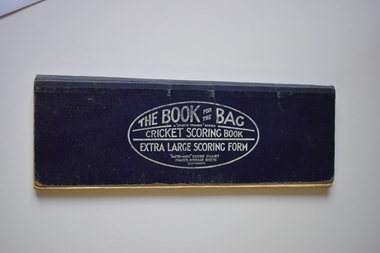
Administrative record - Cricket Scoring Book, 1932/3
... oval. Teams played against include the Catholic Young Men's Society, Bushfield Cricket Club, Australian Natives Association, the Footballers, the Indians, the Woollen Mill Cricket Club, Camperdown and Nirranda-Naringal. This item is of considerable interest as it is a memento of the Warrnambool High School Cricket Team in the 1930s with the list of players names providing a tool for further research. ...This booklet gives details of the matches played by the Warrnambool High School Cricket Club, A Grade Team, for the 1932-33 season. The home ground appeared to be the one at the Showgrounds but they also played at the Woollen Mill oval. Teams played against include the Catholic Young Men's Society, Bushfield Cricket Club, Australian Natives Association, the Footballers, the Indians, the Woollen Mill Cricket Club, Camperdown and Nirranda-Naringal.This item is of considerable interest as it is a memento of the Warrnambool High School Cricket Team in the 1930s with the list of players names providing a tool for further research.A hard cover book, coloured blue, with a with white printing on the front and pages with green columns, green printing and handwritten entries in black ink. The cover is partly detached from the pages.Warrnambool High School Cricket Club A Team Season 1932-33 J. Whitehead Hon Sec F.G.N. Ewence - Scorerswarrnambool cricket, cricket scoring book, warrnambool high school cricket club, 1932 -
 Warrnambool and District Historical Society Inc.
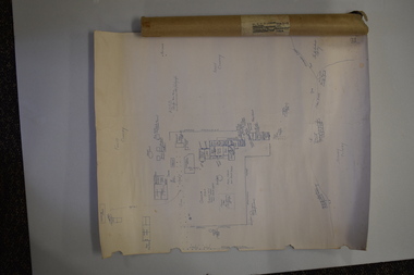
Document (Sketch Plan of Dunmore), Stan Baulch, 1972
... research. Dunmore Property Western Victoria Baulch family Dunmore Homestead & History by S. Baulch Dunmore Homestead drawn by Stan Baulch c.1972 This is a sheet of white lightweight cardboard with a pencilled sketch on one side and a blue ink sketch plan of a house on the other side. The edges of the card have some torn sections. The card is enclosed in an oval ...This card has a sketch map showing the properties surrounding Dunmore on one side and a detailed sketch plan of Dunmore homestead in the early 1970s on the other side. The plan of Dunmore homestead shows interesting features such as the brick oven for bread making, the croquet lawn, the site of the aboriginal mia mias, the Turkish baths and the fowl house used later as a poison house. Francis and Ann Baulch were pioneer settlers in the Kirkstall area and their son Samuel worked at Dunmore in the Macarthur area before purchasing in the early 1870s the property he named Rose Park. In the 1890s he acquired property in the Dunmore estate and his son Stan Baulch gained a section of the Dunmore property after his father’s death. Stan Baulch named this Dunmore section, Rose Park, a property to the west of his father’s original Rose Park property. Stan Baulch was a long time member of the Warrnambool & District Historical Society and he contributed many local history articles and donated many local artefacts to the Society.This sketch plan is of interest as it tells us what the historic homestead of Dunmore in Western Victoria was like in the early 1970s. It will be useful for research. This is a sheet of white lightweight cardboard with a pencilled sketch on one side and a blue ink sketch plan of a house on the other side. The edges of the card have some torn sections. The card is enclosed in an oval cardboard cylinder (recycled and torn at the ends). Both the card and the cover have handwritten titles in ink. Dunmore Homestead & History by S. Baulch Dunmore Homestead drawn by Stan Baulch c.1972 dunmore property, western victoria, baulch family -
 Warrnambool and District Historical Society Inc.
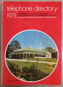
Book, Telephone Directory 1973, 1973
... research purposes. warrnambool warrnambool telephone directory 1973 Front cover – Telephone Directory 1973, Camperdown, Casterton, Edenhope, Hamilton, Portland, Warrnambool districts. See back cover for area covered by this directory Spine – Camperdown, Casterton, Edenhope, Hamilton, Portland, Warrnambool districts. See the pink pages for business & trade listings. VI- 1973 Back Cover – Country directory areas. The area covered by this Directory is the coloured portion of this map. See the pink pages for business and trade listings. This is a soft cover booklet with a red cover and an oval ...The numbers listed in this directory are under the heading of districts and the listings within the districts are again sub-listed under the various towns. So in the Warrnambool district there are listings under Winslow, Panmure, Orford, Port Fairy. Wangoom etc.This directory is of some importance as the names and addresses of those with telephones in 1973 in the local areas are listed. Most of the listings of the smaller towns give the names of the homes and properties. So this is a very useful tool for research purposes.This is a soft cover booklet with a red cover and an oval-shaped insert colour photograph of Stony Point Homestead, Darlington, on the front cover and a map of the telephone area on the back cover. Front cover – Telephone Directory 1973, Camperdown, Casterton, Edenhope, Hamilton, Portland, Warrnambool districts. See back cover for area covered by this directory Spine – Camperdown, Casterton, Edenhope, Hamilton, Portland, Warrnambool districts. See the pink pages for business & trade listings. VI- 1973 Back Cover – Country directory areas. The area covered by this Directory is the coloured portion of this map. See the pink pages for business and trade listings. warrnambool, warrnambool telephone directory 1973 -
 Orbost & District Historical Society
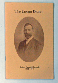
book, Research Publications Pty Ltd, The Ensign Bearer, July 1981
... This is a useful research tool on the history of Robert Campbell Edwards. book-The-Ensign-Bearer Green-Oswald-Stuart Campbell-Edwards-Trust on title page "With Kind Regards O S Green" handwritten in blue pen A thin soft cover book with a light brown cover with dark brown print. On the front cover is an oval ...In 1922 Robert Campbell Edwards (1862-1946) established the Campbell Edwards Trust for religious, educational and charitable purposes. This book is the story of Robert Campbell Edwards' life from his birth in Drumgowan, Ireland until his death in South Yarra, Victoria. The Campbell Edwards Trust trust is still operating today.This is a useful research tool on the history of Robert Campbell Edwards.A thin soft cover book with a light brown cover with dark brown print. On the front cover is an oval shaped photograph of Robert Campbell Edwards.on title page "With Kind Regards O S Green" handwritten in blue penbook-the-ensign-bearer green-oswald-stuart campbell-edwards-trust -
 Orbost & District Historical Society
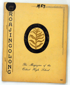
magazine, Croajingolong 1957, 1957
... This 10th issue of the annual Orbost High School magazine is a useful research tool. croajingolong orbost-high-school A stapled 50 pp magazine with a cream cover with dark blue printing : Croajingolong vertically on the left hand side. The Orbost High School crest , a dark blue oval ...This is the tenth issue of the Orbost High School annual magazine. The name Croajingolong derives from the Australian Aboriginal Krauatungalung words galung, meaning "belonging to" and kraua, meaning "east". This magazine belonged to Mary Gilbert, a former teacher at the school.This 10th issue of the annual Orbost High School magazine is a useful research tool.A stapled 50 pp magazine with a cream cover with dark blue printing : Croajingolong vertically on the left hand side. The Orbost High School crest , a dark blue oval around a a sheaf of yellow corn is in the centre. The cover has been professionally printed while the contents are rough printed.croajingolong orbost-high-school -
 Ballan Shire Historical Society
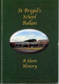
Book - Book. St. Brigid's School, Ballan, St Brigid's School Ballan. A Short History, 2010
... Significant to past and present students and staff, also to those researching family history and education within the local area. schools ballan st brigids catholic schools A small paperback book with an olive green cover on which is centered an oval coloured photograph of the school. 62 pages. ...A short history of St. Brigid's (Catholic) School from it's beginnings as the Ballan Catholic Common School No. 100 at St. Agnes Church c. 1859 up to the present in 2010. The book contains teacher and class photographs, information on the establishment of Catholic Schools in Victoria, and a section on the history of Catholics in Ballan and the beginnings of the Church community. Recent events are covered as are recollections and interviews with former pupils.Significant to past and present students and staff, also to those researching family history and education within the local area.A small paperback book with an olive green cover on which is centered an oval coloured photograph of the school. 62 pages.schools, ballan, st brigids, catholic schools -
 The Beechworth Burke Museum
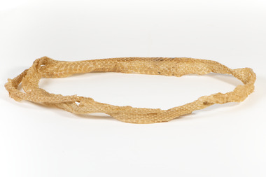
Animal specimen - Snake Skin, Trustees of the Australian Museum, 1860-1880
... research. This collection continues to be on display in the Museum and has become a key part to interpreting the collecting habits of the 19th century. taxidermy mount taxidermy animalia burke museum beechworth australian museum skin reynell eveleigh johns snake skin snake reptile Caramel coloured long snake skin curled around in an oval shape. ...There is no known information about the species of snake that this skin belongs to. However, generally speaking, Australia has over two hundred known species of snakes. They are elongated, legless and carnivorous reptiles with scaly, textured skin. Snakes are especially important in Aboriginal dreaming, representing one of the great and powerful forces of nature and spirit. In the Rainbow Serpent Dreamtime story, they are considered the great life giver and protector of water, which is their spiritual home. This specimen is part of a collection of almost 200 animal specimens that were originally acquired as skins from various institutions across Australia, including the Australian Museum and the National Museum of Victoria, as well as individuals such amateur anthropologist Reynell Eveleigh Johns between 1860-1880. These skins were then mounted by members of the Burke Museum Committee and put-on display in the formal space of the Museum’s original exhibition hall where they continue to be on display. This display of taxidermy mounts initially served to instruct visitors to the Burke Museum of the natural world around them, today it serves as an insight into the collecting habits of the 19th century. This specimen is part of a significant and rare taxidermy mount collection in the Burke Museum. This collection is scientifically and culturally important for reminding us of how science continues to shape our understanding of the modern world. They demonstrate a capacity to hold evidence of how Australia’s fauna history existed in the past and are potentially important for future environmental research. This collection continues to be on display in the Museum and has become a key part to interpreting the collecting habits of the 19th century.Caramel coloured long snake skin curled around in an oval shape.taxidermy mount, taxidermy, animalia, burke museum, beechworth, australian museum, skin, reynell eveleigh johns, snake skin, snake, reptile -
 Eltham District Historical Society Inc
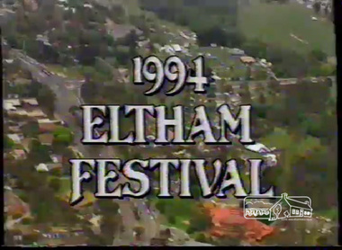
Film - Video (VHS), Dynavision Video Production, 1994 Eltham Festival, 11 Nov 1994
... Research Primary School, Ron Sampson, Salvation Army Band (Briar Hill), Sherbourne Primary School, Shire of Eltham, State Emergency Service (Eltham) and Woodridge Pre-school. The parade commentary was provided by Plenty Valley FM 88.6 with guest commentator, Shire President Cr. John Graves. Following the parade is video footage from a helicopter of Alistair Knox Park, displays along Main Road and activities in Alistair Knox Park and the Rugby oval...Research Primary School, Ron Sampson, Salvation Army Band (Briar Hill), Sherbourne Primary School, Shire of Eltham, State Emergency Service (Eltham) and Woodridge Pre-school. The parade commentary was provided by Plenty Valley FM 88.6 with guest commentator, Shire President Cr. John Graves. Following the parade is video footage from a helicopter of Alistair Knox Park, displays along Main Road and activities in Alistair Knox Park and the Rugby oval ...20th Eltham Community Festival and last under the auspices of the Shire of Eltham. The Grand Parade focussing on the theme "Echoes of Eltham - Celebrating the visions of Eltrham from the past and into the future" was headed by Jock Read on his horse Lofty who had been filmed in an Anzac Day Parade on an earlier horse which had featured in the television show Matlock. The parade travelled north along Main Street to just past the Post Office then back south to Panther Place. Parade participants included 1st Eltham Brownies, 1st Eltham Venturers, 2nd Eltham Sea Scouts, 2nd Eltham Venturers, 3rd Eltham Brownies, Australian Democrats, Briar Hill Primary School, Circus Chaos, Country Fire Authority, Diamond Valley People for Disarmament, Diamond Valley Railway, Eltham Community Health Centre, Eltham District Horse and Pony Club, Eltham East Primary School, Eltham Fire Brigade, Eltham Junior Football Club (Panthers), Eltham Little Theatre, Eltham North Primary School, Eltham Playhouse Co-op, Eltham Pre-school, Eltham Roller Skating Club, Eltham South Pre-School Centre, Eltham Steam and Stationary Engine Society, Greenhills Neighbourhood House, Heidelberg Municipal Band, Hurstbridge Learning Co-op, Jocklebeary Farm, Kangaroo Ground Primary School, Learning Co-op Primary School, Lower Plenty Primary School, Main Road, Montmorency Gardening Club, Montmorency South Primary School, North Warrandyte Fire Brigade, Plenty Valley 88.6 FM, Research Pre-school, Research Primary School, Ron Sampson, Salvation Army Band (Briar Hill), Sherbourne Primary School, Shire of Eltham, State Emergency Service (Eltham) and Woodridge Pre-school. The parade commentary was provided by Plenty Valley FM 88.6 with guest commentator, Shire President Cr. John Graves. Following the parade is video footage from a helicopter of Alistair Knox Park, displays along Main Road and activities in Alistair Knox Park and the Rugby oval along with stationary engines, helicopter joyrides, Eltham People's Choir, music entertainment. Scenes also from the Diamond Valley Railway at Eltham Lower Park and finishing with the fireworks display. At the end of the video is a promotional video for Dynavision Video Production, a local video production company that produced the video and Diamond Photos (Kodak Express). One of the highlights of the festival was a tree planting ceremony in Alistair Knox Park to celebrate 123 years of the Shire of Eltham led by Shire President Cr. John Graves and representatives of the Wurrundjeri, traditional land owners of the area.VHS Video cassette (poor quality) Converted to MP4 file format 45:01, 535MB DVD copy of VHS cassette (better quality)1st eltham brownies, 1st eltham venturers, 2nd eltham sea scouts, 2nd eltham venturers, 3rd eltham brownies, 1994, aerial photographs, alistair knox park, arthur street, australian democrats, briar hill primary school, circus chaos, country fire authority, diamond valley people for disarmament, diamond valley railway, eltham community health centre, eltham district horse and pony club, eltham east primary school, eltham festival, eltham fire brigade, eltham junior football club (panthers), eltham little theatre, eltham lower park, eltham north primary school, eltham people's choir, eltham playhouse co-op, eltham pre-school, eltham roller skating club, eltham south pre-school centre, eltham steam and stationary engine society, grand parade, greenhills neighbourhood house, heidelberg municipal band, hurstbridge learning co-op, jock read, jocklebeary farm, john graves, kangaroo ground primary school, learning co-op primary school, lofty (horse), lower plenty primary school, main road, matlock police (tv show), montmorency gardening club, montmorency south primary school, nicholaus lauder estate, north warrandyte fire brigade, plenty valley 88.6 fm, research pre-school, research primary school, ron sampson, salvation army band (briar hill), sherbourne primary school, shire of eltham, state emergency service (eltham), video recording, woodridge pre-school -
 Eltham District Historical Society Inc
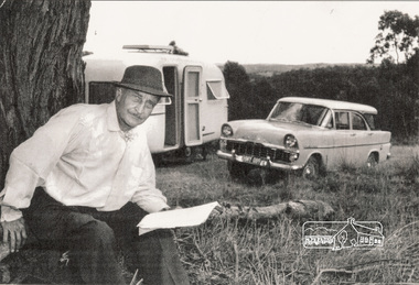
Photograph, Alan Marshall with his Sunliner caravan at Research, Vic, c.1962
... Research and often lived there in his caravan while he was writing. A story about this land is told by John Morrison in "The Writer and the Swagman", which appears in his book "Australian by Choice." Local people also remember Alan living in his caravan beside an old house occupied by his friend, artist Neil Douglas, which was situated on the site of the present-day Eltham College oval and owned by the Pelling family at that time. ...Research and often lived there in his caravan while he was writing. A story about this land is told by John Morrison in "The Writer and the Swagman", which appears in his book "Australian by Choice." Local people also remember Alan living in his caravan beside an old house occupied by his friend, artist Neil Douglas, which was situated on the site of the present-day Eltham College oval and owned by the Pelling family at that time. ...Author Alan Marshall lived at Eltham from 1955 to about 1981. Alan owned land at Research and often lived there in his caravan while he was writing. A story about this land is told by John Morrison in "The Writer and the Swagman", which appears in his book "Australian by Choice." Local people also remember Alan living in his caravan beside an old house occupied by his friend, artist Neil Douglas, which was situated on the site of the present-day Eltham College oval and owned by the Pelling family at that time. It is understood that the land owned by Alan Marshall was nearby in Cassells Road. Vivienne Turner of Eltham recalled that her family had a photo of Alan and his caravan at Research and a copy was provided to EDHS in 2003. The caravan was a Sunliner model. See EDHS Newsletter No 151 July 2003Black and white photograph, injet print on paper alan marshall, caravan, research (vic.), eltham college, neil douglas, pelling family, turner family, sunliner caravan, ek holden special station sedan, cars, 1962 -
 Eltham District Historical Society Inc
Photograph, Demolishing the Bini Shell at Diamond Creek, 1991, 1991
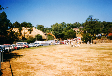
... Research by L.P. Jan 2022 This was the first public building in Victoria to be erected using the Bini Shell design method of construction. 1991 diamond creek Bini Shell demolition oval Colour photograph Demolishing the Bini Shell at Diamond Creek, 1991 Photograph Photograph ...In 1978 Diamond Valley Shire recognised the need for a new public hall in Diamond Creek. Council considered the Bini shell form of construction which was in operation overseas and in use in New South Wales as libraries, gymnasiums, sports centres and multi-purpose centres. The Council gave the go-ahead. A site was chosen opposite the Hotel and close to the railway line. One day in - the following year, in 1979, activity stood still in Diamond Creek as school children and other excited spectators watched the one-hour inflation of the Bini Shell. This unusual method of construction was invented by Italian industrial designer and architect Dante Bini. The construction pneumatically raises a level of reinforced concrete from ground level which has not been set, using an internal balloon. The inner membrane inflates and compresses the mesh and concrete against the outer membrane. A net of flexible steel rods was laid on the building’s circular base, on the top of a fabric bladder. 300 tonnes of reinforced concrete were poured onto the mesh and a sealed cover laid over the concrete making a sandwich of cover, bladder and mesh. Compressed air was pumped into the bladder and the sandwich slowly began to rise and become a massive self-supporting dome. After inflation and removal of the outer membrane workmen filled in any holes. It was some days before pneumatic drills pecked out the first opening. The ceiling of the concrete dome was lined with fluffy insulating material. The dome was 36 metres in diameter at the base and 12 metres high in the centre with a usable floor space of 670 square metres. An opening night dinner was held to celebrate the new facility on March 12, 1980. Shire President Ron Pata made a speech and unveiled a plaque. It was the first public building in Victoria to be erected using the Bini Shell design method of construction The facility could cater for up to 400 people and in 1980 a fee for use was $100 for up to 200 people, $150 for up to 300 people and $200 for up to 400 people. For the next ten years or so, locals attended the hall for marital arts classes, basketball and netball games and school discoes and various other activities. After pieces of concrete fell off a Bini shell interstate due to a construction fault, the Council closed the centre. Demotion took place during the Diamond Creek Town Fair in 1991, as part of the annual Town Fair’s program. Research by L.P. Jan 2022This was the first public building in Victoria to be erected using the Bini Shell design method of construction.Colour photograph1991, diamond creek, bini shell, demolition, oval -
 Bendigo Historical Society Inc.
Postcard - Alice McGregor Postcard Collection, 1900 - 1920
... research. Postcard Album of Alice McGregor contained 86 post cards. POSTCARD Collector Alice McGregor Addressed to M Shatford, Black Rock, Sandringham With a One Penny stamp Postcard Album of Alice McGregor containing 86 post cards. See 1400. B&W photo of trees and shrubs in the 'Municipal Gardens, Brighton Beach' in an oval ...Alice McGREGOR Born: 1908; unknown parents. Possibly adopted by the Salter family? Electoral Roll 1936: Highland Terrace Kangaroo Flat. Alice Mary Salter and William Robert Salter living together; presumed to be sister and brother. William Robert Salter was killed in a MVA in Bendigo in 1937 aged 26. In Victoria in 1938, Alice Mary Salter married James Thomas McGregor (born Victoria 1917, died Victoria 1983, buried Fawkner Cemetery) Lived: 1968; 22 Wade Street Golden Square Alice McGregor Died: 1999 aged 91 at Anne Caudle Centre, Bendigo Buried: Kangaroo Flat Cemetery See additional research. Postcard Album of Alice McGregor contained 86 post cards.Postcard Album of Alice McGregor containing 86 post cards. See 1400. B&W photo of trees and shrubs in the 'Municipal Gardens, Brighton Beach' in an oval frame. Dated 28/12/05 Addressed to M Shatford, Black Rock, Sandringham With a One Penny stamp postcard, collector, alice mcgregor -
 Port Melbourne Historical & Preservation Society
Document - Research report, David Nicholls et al, "Home of the Borough"
... Research document produced as part of the APP project. Sport - Australian Rules Football VFL 'Arms' ARMSTRONG Norm GOSS Snr Nick BLOOM Fred COOK Peter BROMLEY Barry KIDD Hannah LEWI David NICHOLLS Greg DERMOTT Port Melbourne Cricket Ground North Port Oval "Home of the Borough". ...Research document produced as part of the APP project."Home of the Borough". Six page photocopied document on use and value of Port Melbourne Football Ground in the 21st Centurysport - australian rules football, vfl, 'arms' armstrong, norm goss snr, nick bloom, fred cook, peter bromley, barry kidd, hannah lewi, david nicholls, greg dermott, port melbourne cricket ground, north port oval -
 Flagstaff Hill Maritime Museum and Village
Functional object - Nail
... research and education purposes. The Grange is an example of a mid-19th century vessel that carried a weapon of defence onboard. flagstaff hill warrnambool flagstaff hill maritime museum maritime museum shipwreck coast flagstaff hill maritime village great ocean road west coast trader apollo bay mid-19th century shipwreck the grange scottish barque little henty reef captain a alexander underwater explorers club of victoria 1840s carronade vhr 5297 coastal trader wooden shipwreck john chance fastener nail square nail machine cut mail blacksmith historic nail bronze nail carronade mal brown Nail, bronze, oval head, four-sided shank, tip flattened to a rounded wedge shape. ...This historic bronze nail dates back to 1840s when the ship Grange was built. Nails such as this one were used for boat building, as deck fasteners and many other uses. This nail was made at a time when the shanks of nails were usually machine cut but the heads were hand formed by blacksmiths. The nail was recovered from the shipwreck of the Grange in around 1968, 110 years after the Grange was wrecked (see below for further details on the Grange). It is part of the John Chance Collection. THE GRANGE, 1840-1858- The wooden barque ’Grange’ was a three-masted ship built in Scotland in 1840 for international and coastal trade. On March 22, 1858, the Grange set sail from Melbourne under Captain A. Alexander, carrying a cargo of ballast. The barque had left the Heads of Phillip Bay and was heading west along the Victorian coast towards Cape Otway. The ship struck Little Haley’s Reef at Apollo Bay due to a navigational error and was stuck on the rocks. The crew left the ship carrying whatever they could onto the beach. Eventually, the remains of the hull, sails and fittings were salvaged before the wreck of the Grange broke up about a month later. About 110 years later, in 1968, the wreck of the Grange was found by divers from the Underwater Explorers Club of Victoria. They were amazed to find a unique, six to nine pound carronade (type of small cannon) and a cannonball on the site. There have been no other similar carronades recorded. In that same year the anchor of the Grange was recovered by diver John Chance and Mal Brown. The nail is significant historically as an example of hardware used when building wooden ships in the early to mid-19th century. The nail is historically significant as an example of the work and trade of blacksmith. The nail also has significant as it was recovered by John Chance, a diver from the wreck of the Grange in the 1968. Items that come from several wrecks along Victoria's coast have since been donated to the Flagstaff Hill Maritime Village’s museum collection by his family, illustrating this item’s level of historical value. The nail is historically significant for its association with the 1840s wooden barque, the Grange. The Grange is an historical example of a Scottish built vessel used for international and coastal trader of both cargo and passengers in the mid-19th century. The Grange is an example of an early ship, designed with a wooden hull. It is significant as a ship still available to divers along the south coast of Victoria, for research and education purposes. The Grange is an example of a mid-19th century vessel that carried a weapon of defence onboard.Nail, bronze, oval head, four-sided shank, tip flattened to a rounded wedge shape. The surface is pitted and rough. There is orange and blue concretion on the shank. The nail is bent. flagstaff hill, warrnambool, flagstaff hill maritime museum, maritime museum, shipwreck coast, flagstaff hill maritime village, great ocean road, west coast trader, apollo bay, mid-19th century shipwreck, the grange, scottish barque, little henty reef, captain a alexander, underwater explorers club of victoria, 1840s carronade, vhr 5297, coastal trader, wooden shipwreck, john chance, fastener, nail, square nail, machine cut mail, blacksmith, historic nail, bronze nail, carronade, mal brown -
Ringwood and District Historical Society
Badge, Badge with the Coat of Arms of Ringwood, England
... Ellie Pullin was a long serving member of the Ringwood Historical Research Group. Small oval badge with unusual clasp at back. ...Given to Ellie Pullin during a visit to Ringwood, England. The coat of arms is of the English Ringwood. Ellie Pullin was a long serving member of the Ringwood Historical Research Group.Small oval badge with unusual clasp at back. Metal, brass coloured, with crown over shield in blue enamel. Given to Ellie Pullin during a visit to Ringwood, England. The coat of arms is of the English Ringwood. +Additional Keywords: Pullin, Ellie -
 Orbost & District Historical Society
black and white photograph, late 19th century - early 20th century
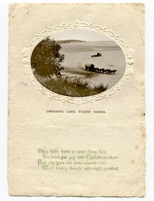
... researchers. They are very interesting records of places gone, architecture gone and people gone, showing social history such as dress, or early automobiles. This one record an earlier means of transport in east Gippsland. Lake-Tyers-East-Gippsland greeting-card on front just below photograph - CROSSING LAKE TYERS SANDS Beneath that in cursive script is " This little view is sent from here To wish you joy and Christmas cheer And say you are remembered still with kindly thoughts and right goodwill" A small black / white oval shaped photograph set in a cream card with green writing at the bottom. ...This photograph has been set as Christmas postcard. It could be the front page of a greeting card.Postcards and greeting form a vital part of social and historical records for researchers. They are very interesting records of places gone, architecture gone and people gone, showing social history such as dress, or early automobiles. This one record an earlier means of transport in east Gippsland.A small black / white oval shaped photograph set in a cream card with green writing at the bottom. The photo is of two horse teams and buggies crossing a large sandy beach.on front just below photograph - CROSSING LAKE TYERS SANDS Beneath that in cursive script is " This little view is sent from here To wish you joy and Christmas cheer And say you are remembered still with kindly thoughts and right goodwill"lake-tyers-east-gippsland greeting-card -
 Orbost & District Historical Society
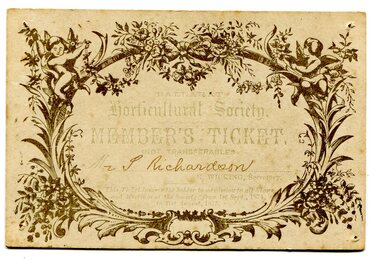
membership ticket, September 1 1874
... This is a useful research tool. ballarat-horticultural-society richardson-samuel on back - hand-written - "J E Richardson" An ornately designed card with an oval frame of flowers and cherubs. ...The Richardson family was one of the very early settler families to establish themselves in the Orbost district. Samuel Richardson was a sawmiller and farmer in Orbost. He built The Curlip, a wooden paddle-steamer of 9 tons gross and dimensions of 43 feet long, 10 feet wide and a depth of 3 feet, on the slipway at their Tabarra sawmill in 1890. The Ballarat Horticultural Society was established in 1859 by a group of thirteen men with the aim of establishing an association for all lovers of horticulture. There were many such societies throughout the colonies making a contribution to their communities. In May 1852 Richard Wicking and his younger brother Frederick followed their father’s footsteps, leaving England to pursue a new life in the distant colony of Port Phillip. Sailing on the maiden voyage of the 'Roxburgh Castle' a new purpose built ship for the long voyages from London to Australia. Arriving on August 28th 1852, having paid their own fares they were "Unassisted Passengers". The brothers spent two years in Melbourne. He spent some tome in Ballarat and became a prominent community member involved in many areas.The Richardson family was one of the very early settler families to establish themselves in the Orbost district. Samuel Richardson was builder of the Paddle Steamer Curlip. This is a useful research tool. An ornately designed card with an oval frame of flowers and cherubs. It is a Ballarat Agricultural Society membership ticket made out to Mr S. Richardson (hand written) and endorsed by R. Wicking , the secretary.on back - hand-written - "J E Richardson"ballarat-horticultural-society richardson-samuel