Showing 417 items matching "right of way"
-
 Kew Historical Society Inc
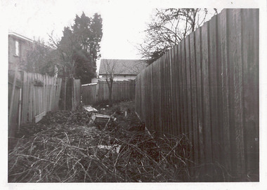
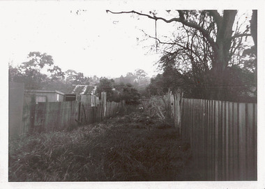
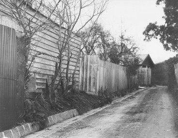
Photograph - Right-of-way at rear of Parkhill Road and Lalla Street, 1973
... Right-of-way at rear of Parkhill Road and Lalla Street...The right-of-way is overgrown preventing access or egress....The right-of-way is overgrown preventing access or egress. ...One of a series of photographs donated by the City Engineer of the former City of Kew, relating to road works. The photos variably include council workers, signage and equipment.One of a series of photographs of core local government services as practised by the City of Kew. The photographs are an accurate record of street works of the period.Original black and white photographic positive of a right-of-way at the rear of houses in Parkhill Road and Lalla street, Kew. The right-of-way is overgrown preventing access or egress."ROW AT REAR OF PROPERTIES / PARKHILL RD / LALLA ST / JULY '73"city of kew, local government -- city of kew, right-of-ways -- kew (vic.), lanes -- kew (vic.), parkhill road, lalla street, council works -
 Sunshine and District Historical Society Incorporated
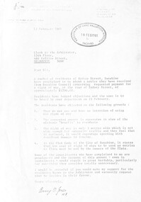
Letter - City of Sunshine - Commissioner Mr Alexander Alex George Gillon Collection 1976 - 1982 - Barry Jones Letter Sydney Street Right of Way 13th February 1981, 13th February 1981
... City of Sunshine - Commissioner Mr Alexander Alex George Gillon Collection 1976 - 1982 - Barry Jones Letter Sydney Street Right of Way 13th February 1981...Letter of complaint to Council regarding request of payment for a right of way at the rear of Sydney Street...Syndey Street Albion Letter of complaint to Council regarding request of payment for a right of way at the rear of Sydney Street Paper document. ...Letter of complaint to Council regarding request of payment for a right of way at the rear of Sydney Streetsyndey street, albion -
 Kew Historical Society Inc
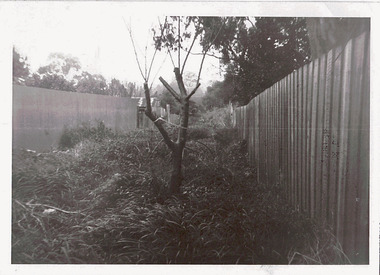
Photograph - Right-of-way at rear of Parkhill Road and Lalla Street, 1973
... Right-of-way at rear of Parkhill Road and Lalla Street...Original black and white photographic an overgrown right-of-way at the rear of properties in Parkhill Road and Lalla Street, Kew...The photographs are an accurate record of council works of the period. city of kew local government -- city of kew council works street maintenance right-of-ways lanes "ROW AT REAR OF PROPERTIES / PARKHILL RD / LALLA ST / JULY '73" Original black and white photographic an overgrown right-of-way at the rear of properties in Parkhill Road and Lalla Street, Kew Photograph Right-of-way at rear of Parkhill Road and Lalla Street ...One of a series of photographs donated by the City Engineer of the former City of Kew, relating to road works and rubbish removal.One of a series of photographs of core local government services as practised by the City of Kew. The photographs are an accurate record of council works of the period.Original black and white photographic an overgrown right-of-way at the rear of properties in Parkhill Road and Lalla Street, Kew"ROW AT REAR OF PROPERTIES / PARKHILL RD / LALLA ST / JULY '73"city of kew, local government -- city of kew, council works, street maintenance, right-of-ways, lanes -
 Kew Historical Society Inc
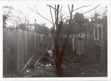
Photograph - Right-of-way at rear of Parkhill Road and Lalla Street, 1973
... Right-of-way at rear of Parkhill Road and Lalla Street...Original black and white photographic positive of an overgrown right-of-way at the rear of properties in Parkhill Road and Lalla Street, Kew. ...Photograph Right-of-way at rear of Parkhill Road and Lalla Street ...One of a series of photographs donated by the City Engineer of the former City of Kew, relating to road works and rubbish removal.One of a series of photographs of core local government services as practised by the City of Kew. The photographs are an accurate record of council works of the period.Original black and white photographic positive of an overgrown right-of-way at the rear of properties in Parkhill Road and Lalla Street, Kew. "ROW AT REAR OF PROPERTIES / PARKHILL RD / LALLA ST / JULY '73"city of kew, local government -- city of kew, rubbish removal, garbage, council works, street maintenance -
 Kew Historical Society Inc
Photograph - Right-of-way at rear of Parkhill Road and Lalla Street, 1973
... Right-of-way at rear of Parkhill Road and Lalla Street...Original black and white photographic of an overgrown right-of-way at the rear of houses in Parkhill Road and Lalla Street, Kew, in 1973....Photograph Right-of-way at rear of Parkhill Road and Lalla Street ...One of a series of photographs donated by the City Engineer of the former City of Kew, relating to road works and rubbish removal.One of a series of photographs of core local government services as practised by the City of Kew. The photographs are an accurate record of council works of the period.Original black and white photographic of an overgrown right-of-way at the rear of houses in Parkhill Road and Lalla Street, Kew, in 1973."ROW AT REAR OF PROPERTIES / PARKHILL RD / LALLA ST / JULY '73"city of kew, local government -- city of kew, right-of-ways, lanes, parkhill road, lalla street -
 Sunshine and District Historical Society Incorporated
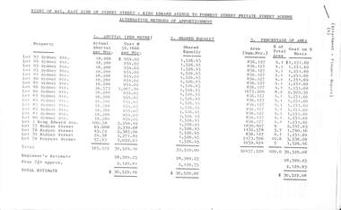
Administrative record - City of Sunshine - Commissioner Mr Alexander Alex George Gillon Collection 1976 - 1982 - Right Of Way Alternative Methods of Apportionment 1980, City of Sunshine, 1980
... City of Sunshine - Commissioner Mr Alexander Alex George Gillon Collection 1976 - 1982 - Right Of Way Alternative Methods of Apportionment 1980...Right of Way, East Side of Sydney Street - King Edward Avenue to Forrest Street Private Street Scheme Alternative Methods of Apportionment...Administrative record City of Sunshine - Commissioner Mr Alexander Alex George Gillon Collection 1976 - 1982 - Right Of Way Alternative Methods of Apportionment 1980 City of Sunshine ...Right of Way, East Side of Sydney Street - King Edward Avenue to Forrest Street Private Street Scheme Alternative Methods of Apportionmentsydney street, king edward avenue, forrest street, albion -
 Whitehorse Historical Society Inc.
Document, Street and Right of Way Construction, 1926 - 1932
... Street and Right of Way Construction...Street and Right of way Construction installment cash book, Shire of Blackburn and Mitcham, 1926 - 1932....Street and Right of Way Construction Document Document ...Street and Right of way Construction installment cash book, Shire of Blackburn and Mitcham, 1926 - 1932.Street and Right of way Construction installment cash book, Shire of Blackburn and Mitcham, 1926 - 1932.Street and Right of way Construction installment cash book, Shire of Blackburn and Mitcham, 1926 - 1932.shire of blackburn and mitcham, roads and streets -
 Ringwood and District Historical Society
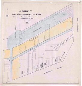
Map, Development of Right of Way Stage 2, Ringwood, Victoria - 1950
... Development of Right of Way Stage 2, Ringwood, Victoria - 1950...Borough Engineer's technical drawing for Development of Right of Way between Adelaide Street and Warrandyte Road, Ringwood, showing existing retail establishments and outbuildings, and area available for lock-up shops....Development of Right of Way Stage 2, Ringwood, Victoria - 1950 Map ...Borough Engineer's technical drawing for Development of Right of Way between Adelaide Street and Warrandyte Road, Ringwood, showing existing retail establishments and outbuildings, and area available for lock-up shops.Scale 20' = 1". ACR 11.7.50. (Alan Charles Robertson - Borough Engineer) -
 Ringwood and District Historical Society
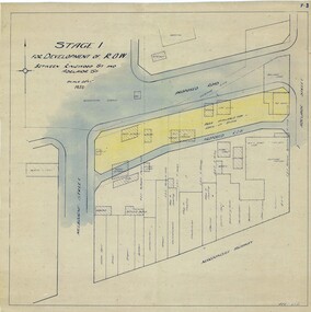
Map, Development of Right of Way Stage 1, Ringwood, Victoria - 1950
... Development of Right of Way Stage 1, Ringwood, Victoria - 1950...Borough Engineer's technical drawing for Development of Right of Way between Ringwood Street and Adelaide Street, Ringwood, showing existing recreation reserve, retail establishments, outbuildings, and area available for lock-up shops....Development of Right of Way Stage 1, Ringwood, Victoria - 1950 Map ...Borough Engineer's technical drawing for Development of Right of Way between Ringwood Street and Adelaide Street, Ringwood, showing existing recreation reserve, retail establishments, outbuildings, and area available for lock-up shops.Scale 20' = 1". ACR 10.7.50. (Alan Charles Robertson - Borough Engineer) -
 Ringwood and District Historical Society
Photograph, Old right of way now Civic Place, Ringwood. 1960's
... Old right of way now Civic Place, Ringwood. 1960's...Written on back of photograph, "ROW Next to Mail Office 1960's) and "Old right of way now Civic Place". Catalogue card reads, "Old right of way which ran from Adelaide St. near hospital. ...Ringwood and District Historical Society 125A Warrandyte Road Ringwood North melbourne Written on back of photograph, "ROW Next to Mail Office 1960's) and "Old right of way now Civic Place". Catalogue card reads, "Old right of way which ran from Adelaide St. near hospital. ...Written on back of photograph, "ROW Next to Mail Office 1960's) and "Old right of way now Civic Place". Catalogue card reads, "Old right of way which ran from Adelaide St. near hospital. When sold it became part of thoroughfare leading to Warrandyte Road. L.H. side present (1987) a garage, R.H. side is Safeways. Right though past Dickins (now National Bank) to Ringwood St. -
 Melbourne Tram Museum
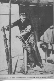
Photograph - Signalman at Collins and Swanton Streets, 1910s
... ...right of way...The signalman's job was twofold: to directed which trams had right of way by use of mechanical signals and to depress the Collins Street cable so that the upward incline did not cause the cable to rise out of the slot onto the roadway. ...The signalman's job was twofold: to directed which trams had right of way by use of mechanical signals and to depress the Collins Street cable so that the upward incline did not cause the cable to rise out of the slot onto the roadway. ...Photograph shows uniformed MTOC signalman standing under a canopy operating two large levers (which may be the reason the newspaper mistakenly described him as a switchman). He stands under a canopy supported by poles with a partial curtain at the rear along with his overcoat. The canopy was located on the footpath on the southeast corner of the intersection of Collins and Swanston Streets. This was the busiest cable tramway intersection in Melbourne and one of the busiest for pedestrian and vehicle traffic. The tram tracks crossed each other at right angles with no curved tracks to permit turns. The signalman's job was twofold: to directed which trams had right of way by use of mechanical signals and to depress the Collins Street cable so that the upward incline did not cause the cable to rise out of the slot onto the roadway. The depression gear was located under both Collins Street tracks adjacent to the Town Hall and was only released momentarily to allow a Collins Street tram to pass over it. This was a demanding job requiring constant vigilance: working with the policeman controlling the intersection, trams approaching from four directions, horse and motor traffic and pedestrians. The signalman's rules provided a specific order of steps each time the signals and depression gear were reset, which occurred many times per hour. He was also authorised to stop trams with the use of his whistle and a red hand lamp and to report gripmen who disobey his directions. Traffic lights were gradually introduced to Melbourne from 1928 after cable trams were replaced in Swanston Street and just before they were replaced in Collins Street. This is a photograph taken of a newsprint photograph from an unnamed newspaper. Yields information about signalman's work. Black and white photograph with note below photograph. Printed below photograph: "Switchman [sic] at the intersection of Collins and Swanston Streets."newsprint, mtoc, switchman, canopy, levers, collins street, swanston street, busiest intersection, traffic lights, 1928, policeman, signalman, mechanical signals, right of way, depression gear, twon hall, slot, vigilance -
Whitehorse Historical Society Inc.
Newspaper - Article, Back lane up for sale, 1/02/2000
... Article on closing of a right-of-way off The Avenue at Blackburn....Whitehorse Historical Society Inc. 2-10 Deep Creek Road Mitcham melbourne Blackburn The Avenue Blackburn Gardenia Street Blackburn Main Street Blackburn Lanes Article on closing of a right-of-way off The Avenue at Blackburn. Back lane up for sale Newspaper Article ...Article on closing of a right-of-way off The Avenue at Blackburn.blackburn, the avenue, blackburn, gardenia street, blackburn, main street, blackburn, lanes -
 Sunshine and District Historical Society Incorporated
Administrative record - City of Sunshine - Commissioner Mr Alexander Alex George Gillon Collection 1976 - 1982 - Notice of ordinary meeting of the council 24th February 2026, City of Sunshine, 18th February 1981
... Proposal to Close Right of Way between and Pizzey Street Sunshine...Barnard Court Pizzey Street Sunshine Proposal to Close Right of Way between and Pizzey Street Sunshine Foolscap sized document. ...Proposal to Close Right of Way between and Pizzey Street Sunshinebarnard court, pizzey street, sunshine -
 Sunshine and District Historical Society Incorporated
Administrative record - City of Sunshine - Commissioner Mr Alexander Alex George Gillon Collection 1976 - 1982 - Notice of ordinary meeting of the council 24th February 1981, City of Sunshine, 18th February 1981
... Proposal to close Right of Way between Barnard Court and Pizzey Street Sunshine...Barnard Court Pizzey Street Sunshine Proposal to close Right of Way between Barnard Court and Pizzey Street Sunshine Foolscap sized document. ...Proposal to close Right of Way between Barnard Court and Pizzey Street Sunshinebarnard court, pizzey street, sunshine -
 Sunshine and District Historical Society Incorporated
Administrative record - City of Sunshine - Commissioner Mr Alexander Alex George Gillon Collection 1976 - 1982 - Notice of ordinary meeting of the council 6th May 2026, City of Sunshine, 6th May 1981
... Land Transfer Former Right of Way off Station Road Deer Park...Station Road Deer Park Land Transfer Former Right of Way off Station Road Deer Park Foolscap sized document. ...Land Transfer Former Right of Way off Station Road Deer Parkstation road, deer park -
 Sunshine and District Historical Society Incorporated
Administrative record - City of Sunshine - Commissioner Mr Alexander Alex George Gillon Collection 1976 - 1982 - Minutes of the ordinary meeting of council held on 24th February 1981, City of Sunshine, 24th February 1981
... Proposal to close Right of Way between Barnard Court and Pizzey Street Sealing of Conveyance 66 Northumberland Road...Barnard Court Pizzey Street Sunshine Northumberland Road Sunshine North Proposal to close Right of Way between Barnard Court and Pizzey Street Sealing of Conveyance 66 Northumberland Road Foolscap sized document. ...Proposal to close Right of Way between Barnard Court and Pizzey Street Sealing of Conveyance 66 Northumberland Roadbarnard court, pizzey street, sunshine, northumberland road, sunshine north -
 Ithacan Historical Society
Photograph, Anthi Chilianis - House no. 3, 1994
... They show a lady standing next to a high brick wall in a narrow right-of-way....They show a lady standing next to a high brick wall in a narrow right-of-way. Anthi Chilianis - House no. 3 Photograph ...Anthi Chilianis is standing in Palmerston Street, Carlton at the site where the house she had lived when she was young for about 12 months was once located. It was the third house that Anthi lived in after arriving in Australia in 1921.Two coloured photographs have been scanned together. They show a lady standing next to a high brick wall in a narrow right-of-way.chilianis, anthi -
 Ballarat Tramway Museum
Photograph - Ballarat tram 13 in bound from Sebastopol, Ken Winney, 12/1949
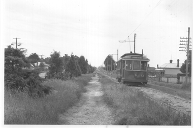
... "Car No. 13 on open right of way 1/2 mile from Sebastopol terminus, Ballarat 12/1949, I K Winney"...Tramcars Sebastopol Albert St. tram 13 "Car No. 13 on open right of way 1/2 mile from Sebastopol terminus, Ballarat 12/1949, I K Winney" Black and white photograph with photographers details on rear. ...The photograph shows SEC Ballarat tram No. 13 just before it crossed Albert St on its way to Lydiard St North. The photo shows the "wilds" or unkempt nature of Albert St at the time. Photo by I K Winney of Sydney, 12/1949.Yields information about tram 13 and the nature of the southern section of Albert St. Sebastopol.Black and white photograph with photographers details on rear."Car No. 13 on open right of way 1/2 mile from Sebastopol terminus, Ballarat 12/1949, I K Winney"tramcars, sebastopol, albert st., tram 13 -
 Dutch Australian Heritage Centre Victoria
Public Warning Sign (Verboden Toegang)
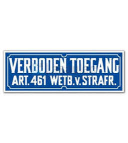
... This is a common sign in The Netherlands were the British "Right of Way" for walkers does not exist....Dutch Australian Heritage Centre Victoria 60 Rosstown Road Carnegie melbourne This is a common sign in The Netherlands were the British "Right of Way" for walkers does not exist. Verboden Toegang. ...This is a common sign in The Netherlands were the British "Right of Way" for walkers does not exist.Small rectangular plastic sign forbidding entry. Verboden Toegang. Art.461. Wetb. v. Strafr. (Non-abbreviated text would read Artikel 461 Wetboek van Strafrecht) In English: Access denied; punishable by article 461 of the penal code. -
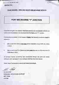 Melbourne Tram Museum
Document - Notice, Met Tram, 'Port Melbourne Y Junction", 14/11/1994
... Document issued drivers at Kew and South Melbourne depots 14/11/1994 concerning the right of way for trams at the 'Port Melbourne Y Junction" - all trams to stop at the compulsory stops and Port Melbourne trams must give right of way to St Kilda Beach LRVs. ...Melbourne Tram Museum 8 Wallen Road Hawthorn melbourne Document issued drivers at Kew and South Melbourne depots 14/11/1994 concerning the right of way for trams at the 'Port Melbourne Y Junction" - all trams to stop at the compulsory stops and Port Melbourne trams must give right of way to St Kilda Beach LRVs. ...Document issued drivers at Kew and South Melbourne depots 14/11/1994 concerning the right of way for trams at the 'Port Melbourne Y Junction" - all trams to stop at the compulsory stops and Port Melbourne trams must give right of way to St Kilda Beach LRVs. Signed by Alan East, Manager Operations Support, Met Tram.Demonstrates instructions issued re the operation of the Port Melbourne Y junction or Port Junction.Document - 1 A4 pages photocopied fax message.tramways, port melbourne, st kilda light rail, drivers, notice, instruction -
Whitehorse Historical Society Inc.
Document, Certificate of Title, 1917 - 1933
... Lots 61 & 62, subdivision 602, Part of Crown Allotment 127, Parish of Nunawading, County of Bourke with a right of carriage way over Harrison and Burnett streets, 1917. ...Lots 61 & 62, subdivision 602, Part of Crown Allotment 127, Parish of Nunawading, County of Bourke with a right of carriage way over Harrison and Burnett streets, 1917. ...Whitehorse Historical Society Inc. 2-10 Deep Creek Road Mitcham melbourne Lots 61 & 62, subdivision 602, Part of Crown Allotment 127, Parish of Nunawading, County of Bourke with a right of carriage way over Harrison and Burnett streets, 1917. ...Certificate of Title, Harrison Rotherham of 'Thulecroft', Albion Street, Surrey Hills, Merchant.Certificate of Title, Harrison Rotherham of 'Thulecroft', Albion Street, Surrey Hills, Merchant. Lots 61 & 62, subdivision 602, Part of Crown Allotment 127, Parish of Nunawading, County of Bourke with a right of carriage way over Harrison and Burnett streets, 1917. Vol 4046, Fol 809049. Also correspondence re rates, enforcement of charge, 1933.Certificate of Title, Harrison Rotherham of 'Thulecroft', Albion Street, Surrey Hills, Merchant.land titles, shire of nunawading, shire of blackburn and mitcham, rotherham, harrison, harrison street, mitcham, burnett street, mitcham -
 Sunshine and District Historical Society Incorporated
Administrative record - City of Sunshine - Commissioner Mr Alexander Alex George Gillon Collection 1976 - 1982 - Notice of ordinary meeting of the council 9th June 2026, City of Sunshine, 20th May 1981
... Land Transfer Part of discontinuer Right of Way between Railway Parade and Wood Street Deer Park Resubdivision of Municipality Sunshine Baseball Club lease / licence Albion Tennis Club lease...Railway Parade Wood Street Deer Park Sunshine Baseball Club Talmage Street Albion Albion Tennis Club Selwyn Park Selwyn Street Land Transfer Part of discontinuer Right of Way between Railway Parade and Wood Street Deer Park Resubdivision of Municipality Sunshine Baseball Club lease / licence Albion Tennis Club lease Foolscap sized document. ...Land Transfer Part of discontinuer Right of Way between Railway Parade and Wood Street Deer Park Resubdivision of Municipality Sunshine Baseball Club lease / licence Albion Tennis Club leaserailway parade, wood street, deer park, sunshine baseball club, talmage street, albion, albion tennis club, selwyn park, selwyn street -
 Bendigo Historical Society Inc.
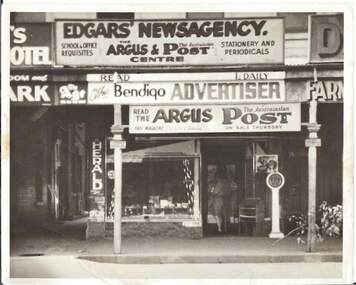
Photograph - EDGAR'S NEWSAGENCY
... Black and white photograph of Edgar's Newsagency showing various newspaper advertisements, glazed tiles bvelow shop window, two figures standing in doorway weighing machine, tree branch on footpath, right-of-way at left of shopfront....History House 11 Mackenzie Street Bendigo goldfields BUILDINGS Commercial edgar's newsagency Black and white photograph of Edgar's Newsagency showing various newspaper advertisements, glazed tiles bvelow shop window, two figures standing in doorway weighing machine, tree branch on footpath, right-of-way at left of shopfront. Photograph EDGAR'S NEWSAGENCY ...Black and white photograph of Edgar's Newsagency showing various newspaper advertisements, glazed tiles bvelow shop window, two figures standing in doorway weighing machine, tree branch on footpath, right-of-way at left of shopfront.buildings, commercial, edgar's newsagency -
 Sunshine and District Historical Society Incorporated
Administrative record - City of Sunshine - Commissioner Mr Alexander Alex George Gillon Collection 1976 - 1982 - Minutes of the ordinary meeting of council held on 12th Dec 1978, City of Sunshine, 12th December 1978
... Land Transfer from Council Right of Way discontinued of Stradbroke Drive Land Transfer Lot 58 Derrimut Street and Lot 89 Wyalong Street to create walkway from Derrimut Street to Wyalong Street (Beside Albion State School) Creation of Easement lot 382 Newbury Street Lease 2 - 4 Burton Street Right of Way rear of shops Main Road West at Cornhill Street Proposed Subdivision of Land Fairbairn Road...Albans Wyalong Street Derrimut Street Albion Albion State School Newbury Street Deer Park Burton Crescent Maribyrnong Main Road West Cornhill Street Land Transfer from Council Right of Way discontinued of Stradbroke Drive Land Transfer Lot 58 Derrimut Street and Lot 89 Wyalong Street to create walkway from Derrimut Street to Wyalong Street (Beside Albion State School) Creation of Easement lot 382 Newbury Street Lease 2 - 4 Burton Street Right of Way rear of shops Main Road West at Cornhill Street Proposed Subdivision of Land Fairbairn Road Foolscap sized document. ...Land Transfer from Council Right of Way discontinued of Stradbroke Drive Land Transfer Lot 58 Derrimut Street and Lot 89 Wyalong Street to create walkway from Derrimut Street to Wyalong Street (Beside Albion State School) Creation of Easement lot 382 Newbury Street Lease 2 - 4 Burton Street Right of Way rear of shops Main Road West at Cornhill Street Proposed Subdivision of Land Fairbairn Road city of sunshine, alexander "alex" george gillon, stradbroke drive, st. albans, wyalong street, derrimut street, albion, albion state school, newbury street, deer park, burton crescent, maribyrnong, main road west, cornhill street -
 Sunshine and District Historical Society Incorporated
Administrative record - City of Sunshine - Commissioner Mr Alexander Alex George Gillon Collection 1976 - 1982 - Notice of ordinary meeting of the council 12th December 1978, City of Sunshine, 6th December 1978
... Land Transfer from Council Right of Way discontinued of Stradbroke Drive Land Transfer Lot 58 Derrimut Street and Lot 89 Wyalong Street to create walkway from Derrimut Street to Wyalong Street (Beside Albion State School) Creation of Easement lot 382 Newbury Street Lease 2 - 4 Burton Street Right of Way rear of shops Main Road West at Cornhill Street Proposed Subdivision of Land Fairbairn Road...Albans Wyalong Street Derrimut Street Albion Albion State School Newbury Street Deer Park Burton Crescent Maribyrnong Main Road West Cornhill Street Land Transfer from Council Right of Way discontinued of Stradbroke Drive Land Transfer Lot 58 Derrimut Street and Lot 89 Wyalong Street to create walkway from Derrimut Street to Wyalong Street (Beside Albion State School) Creation of Easement lot 382 Newbury Street Lease 2 - 4 Burton Street Right of Way rear of shops Main Road West at Cornhill Street Proposed Subdivision of Land Fairbairn Road Foolscap sized document. ...Land Transfer from Council Right of Way discontinued of Stradbroke Drive Land Transfer Lot 58 Derrimut Street and Lot 89 Wyalong Street to create walkway from Derrimut Street to Wyalong Street (Beside Albion State School) Creation of Easement lot 382 Newbury Street Lease 2 - 4 Burton Street Right of Way rear of shops Main Road West at Cornhill Street Proposed Subdivision of Land Fairbairn Road city of sunshine, alexander "alex" george gillon, stradbroke drive, st. albans, wyalong street, derrimut street, albion, albion state school, newbury street, deer park, burton crescent, maribyrnong, main road west, cornhill street -
 Sunshine and District Historical Society Incorporated
Administrative record - City of Sunshine - Commissioner Mr Alexander Alex George Gillon Collection 1976 - 1982 - Notice of ordinary meeting of the council 24th March 2026, City of Sunshine, 18th March 1981
... Lease of Comfort Station with the Victorian Railways Land Acquisition Corner Raleigh Road and Rosamond Road Maribyrnong Transfer of Land Discontinued Right of Way Wright Street near Pinaroo Avenue Sunshine West...Raleigh Road Rosamond Road Maribyrnong Pinaroo Avenue Wright Street Sunshine West Lease of Comfort Station with the Victorian Railways Land Acquisition Corner Raleigh Road and Rosamond Road Maribyrnong Transfer of Land Discontinued Right of Way Wright Street near Pinaroo Avenue Sunshine West Foolscap sized document. ...Lease of Comfort Station with the Victorian Railways Land Acquisition Corner Raleigh Road and Rosamond Road Maribyrnong Transfer of Land Discontinued Right of Way Wright Street near Pinaroo Avenue Sunshine Westraleigh road, rosamond road, maribyrnong, pinaroo avenue, wright street, sunshine west -
 Sunshine and District Historical Society Incorporated
Administrative record - City of Sunshine - Commissioner Mr Alexander Alex George Gillon Collection 1976 - 1982 - Notice of ordinary meeting of the council 14th November 1978, City of Sunshine, 8th November 1978
... The name Furlong has been gazetted Land Transfer Ainsworth Reserve Land Transfer Discontinued right of way between Marsh Street and Emu Street...The name Furlong has been gazetted Land Transfer Ainsworth Reserve Land Transfer Discontinued right of way between Marsh Street and Emu Street Foolscap sized document. ...Name of proposed railway station between Albion and St. Albans. The name Furlong has been gazetted Land Transfer Ainsworth Reserve Land Transfer Discontinued right of way between Marsh Street and Emu Street city of sunshine, alexander "alex" george gillon, emu street, marsh street, maidstone, ainsworth rerserve, vernon street, sunshine west -
 Sunshine and District Historical Society Incorporated
Administrative record - City of Sunshine - Commissioner Mr Alexander Alex George Gillon Collection 1976 - 1982 - Minutes of the ordinary meeting of council held on 14th November 1978, City of Sunshine, 14th November 1978
... The name Furlong has been gazetted Land Transfer Ainsworth Reserve Land Transfer Discontinued right of way between Marsh Street and Emu Street...The name Furlong has been gazetted Land Transfer Ainsworth Reserve Land Transfer Discontinued right of way between Marsh Street and Emu Street Foolscap sized document. ...Name of proposed railway station between Albion and St. Albans. The name Furlong has been gazetted Land Transfer Ainsworth Reserve Land Transfer Discontinued right of way between Marsh Street and Emu Street city of sunshine, alexander "alex" george gillon, emu street, marsh street, maidstone, ainsworth reserve, vernon street, sunshine west -
 Sunshine and District Historical Society Incorporated
Administrative record - City of Sunshine - Commissioner Mr Alexander Alex George Gillon Collection 1976 - 1982 - Minutes of the ordinary meeting of council held on 28th Nov 1978, City of Sunshine, 28th November 1978
... Dempster Park proposed lease to Sunshine Cricket Club Issue of Title on former Devonshire Road between railway line and Anderson Road was discontinued Application for Title former right of way off Railway Parade Deer Park...City of Sunshine Alexander "Alex" George Gillon Sunshine Cricket Club Dempster Park Phoenix Street Sunshine North Devonshire Road Sunshine Gardens Anderson Road Sunshine Railway Parade Deer Park Dempster Park proposed lease to Sunshine Cricket Club Issue of Title on former Devonshire Road between railway line and Anderson Road was discontinued Application for Title former right of way off Railway Parade Deer Park Foolscap sized document. ...Dempster Park proposed lease to Sunshine Cricket Club Issue of Title on former Devonshire Road between railway line and Anderson Road was discontinued Application for Title former right of way off Railway Parade Deer Park city of sunshine, alexander "alex" george gillon, sunshine cricket club, dempster park, phoenix street, sunshine north, devonshire road, sunshine gardens, anderson road, sunshine, railway parade, deer park -
 Sunshine and District Historical Society Incorporated
Administrative record - City of Sunshine - Commissioner Mr Alexander Alex George Gillon Collection 1976 - 1982 - Notice of ordinary meeting of the council 28th November 1978, City of Sunshine, 22nd November 1978
... Dempster Park proposed lease to Sunshine Cricket Club Issue of Title on former Devonshire Road between railway line and Anderson Road was discontinued Application for Title former right of way off Railway Parade Deer Park...City of Sunshine Alexander "Alex" George Gillon Sunshine Cricket Club Dempster Park Phoenix Street Sunshine North Devonshire Road Sunshine Gardens Anderson Road Albion Railway Parade Deer Park Dempster Park proposed lease to Sunshine Cricket Club Issue of Title on former Devonshire Road between railway line and Anderson Road was discontinued Application for Title former right of way off Railway Parade Deer Park Foolscap sized document. ...Dempster Park proposed lease to Sunshine Cricket Club Issue of Title on former Devonshire Road between railway line and Anderson Road was discontinued Application for Title former right of way off Railway Parade Deer Park city of sunshine, alexander "alex" george gillon, sunshine cricket club, dempster park, phoenix street, sunshine north, devonshire road, sunshine gardens, anderson road, albion, railway parade, deer park