Showing 221 items matching "river bend"
-
 Eltham District Historical Society Inc
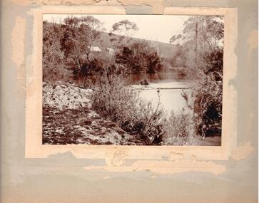
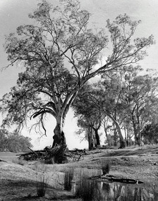
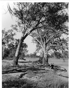
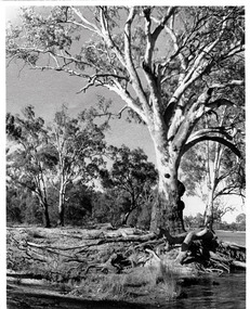
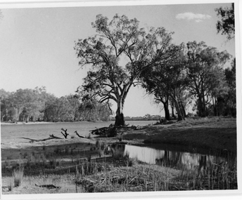
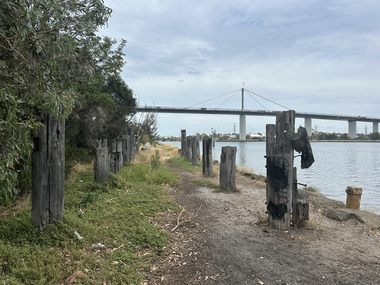
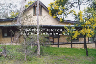
Photograph - Digital Photograph, Jim Connor, River Bend House, 130 Laughing Waters Road, Eltham, 7 September 2013
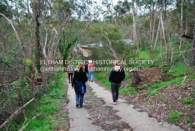
... River Bend House, 130 Laughing Waters Road, Eltham......River Bend House...On the way we visited the two artist in residence properties, River Bend and Birrarung, to view the houses on them that are associated with Alistair Knox, Gordon Ford and others in the local mud brick and artistic community. ...On the way we visited the two artist in residence properties, River Bend and Birrarung, to view the houses on them that are associated with Alistair Knox, Gordon Ford and others in the local mud brick and artistic community. ...Laughing Waters Walk, 7 Sep 2013 This Society excursion was a follow up to the Laughing Waters Story told to us by Jane Woollard at our Annual General Meeting in March 2013. It involved a walk commencing from the corner of Laughing Waters and Overbank Roads along Laughing Waters Road to its eastern end and returning partly over the same route - a total distance of about 2.5km. On the way we visited the two artist in residence properties, River Bend and Birrarung, to view the houses on them that are associated with Alistair Knox, Gordon Ford and others in the local mud brick and artistic community. We also able to walk around the derelict ruin which was once home to Gordon and Sue Ford, Boomerang House. An unexpected afternoon tea was offered to us by the artists in residence at Birrarung House and we had a brief opportunity to view inside the house. River Bend was designed and built by Alistair Knox for Rosemary and Bill Cuming in 1968. It sits in a deep cutting on a steep slope above the Yarra River and features floor to ceiling windows and glass doors set into mission brown timber frames and walls of reclaimed bricks in pinkish hue. Rosemary laid the brick paving around the house, a copy of the shell paving found in the ancient French town of Colmar, where the family had lived for a period. The kitchen was equipped with a 1960s stove as well as a cast iron wood stove reclaimed from Rosemary's sister's home in Armadale. Max and Tini Huygens, migrants from Holland, purchased the property in 1975 and named it Tilwinda from an Aboriginal word meaning 'hole in a rock'. In late 1981 Tini died after a short illness, but Max continued to live at Tilwinda until he moved to a retirement village in 2000 and the property was sold to Parks Victoria. Renamed River Bend, the property became part of the Laughing Waters Artist in Residency Program in 2008. Nillumbik Shire Council upgraded the property in 2012 with solar panels, a heat pump for hot water and double glazing to improve the comfort of the artists in residence and make the house more energy efficient. For a more in-depth description of the property and biographies of the various artists in residence commencing from 2008 to 2015, see Jane Woollard's book, "Laughing Waters Road; Art, Landscape & Memory in Eltham" published 2016.2013-09-07, activities, artists in residence, eltham district historical society, heritage excursion, jim connor collection, laughing waters road, river bend house -
 Greensborough Historical Society
Photograph - Digital image, Marilyn Smith et al, Janefield Precinct: View of river bend, 27/11/2014
... Janefield Precinct: View of river bend....Janefield Precinct: View of river bend. The remains of this site are between Greensborough and Janefield. ...Janefield Precinct: View of river bend. Photograph - Digital image Marilyn Smith Norm Colvin ...Janefield Precinct: View of river bend. The remains of this site are between Greensborough and Janefield. A RAAF Hygiene Training Camp was located on the Plenty River, just south of the Janefield community. It was in use from 1944 to 1946. The Camp was constructed from salvaged materials. Instruction included building and maintenance of grease traps, latrines, elementary plumbing and carpentry.Early remains of a WW2 training camp Digital colour photograph.janefield -
 Eltham District Historical Society Inc
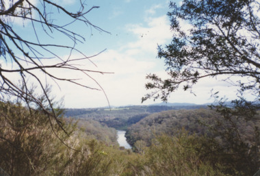
Photograph, Aerial view of Yarra River near Kangaroo Ground - Bend of Islands area
... Aerial view of Yarra River near Kangaroo Ground - Bend of Islands area...bend of isles...kangaroo ground...yarra river...Aerial view of Yarra river at Bend of Islands; Henley Road on left in foreground...Sepia aerial view of Yarra river at Bend of Islands; Henley Road on left in foreground...Aerial view of Yarra river at Bend of Islands; Henley Road on left in foreground bend of isles kangaroo ground yarra river henley road Sepia aerial view of Yarra river at Bend of Islands; Henley Road on left in foreground Aerial view of Yarra River near Kangaroo Ground - Bend of Islands area Photograph ...Aerial view of Yarra river at Bend of Islands; Henley Road on left in foregroundSepia aerial view of Yarra river at Bend of Islands; Henley Road on left in foregroundbend of isles, kangaroo ground, yarra river, henley road -
 Hume City Civic Collection
Photograph
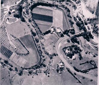
... The aerial photograph shows the market garden situated on the river bend and flat of the Deep Creek at Bulla. ...A black and white aerial photograph of the river bend and river flat of the Deep Creek at Bulla....Hume City Civic Collection 44 Macedon Street Sunbury melbourne The aerial photograph shows the market garden situated on the river bend and flat of the Deep Creek at Bulla. ...The aerial photograph shows the market garden situated on the river bend and flat of the Deep Creek at Bulla. In the 19th Century a hotel occupied the site. After World War II the property was owned by the Hughes family, who grew flowers. In 1971 Andrew Vlass purchased the property and it became a market garden until the Vlass family sold it in 1990.A black and white aerial photograph of the river bend and river flat of the Deep Creek at Bulla.scale - 170 feet = 1 inchdeep creek, market gardens, sunbury road, bulla, horticulture, hughes family, vlass, andrew, hotels, george evans collection -
 Hume City Civic Collection
Photograph
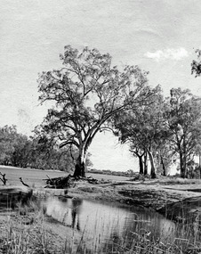
... Could be river bend in Jackson's Creek....A sepia photograph mounted on a cream frame of a river bend. There is a small cottage on the LHS of the photo partly covered with gum trees. ...Hume City Civic Collection 44 Macedon Street Sunbury melbourne Could be river bend in Jackson's Creek. rivers houses jackson's creek landscapes george evans collection A sepia photograph mounted on a cream frame of a river bend. ...Could be river bend in Jackson's Creek.A sepia photograph mounted on a cream frame of a river bend. There is a small cottage on the LHS of the photo partly covered with gum trees. Exotic trees are growing on the RH river bank.rivers, houses, jackson's creek, landscapes, george evans collection -
 Brimbank City Council Art Collection
Painting, Maribyrnong River from Horseshoe Bend Road, Keilor, 1977
... Maribyrnong River from Horseshoe Bend Road, Keilor...Three horses in the foreground - AR0064 Maribyrnong River from Horseshoe Bend Road, Keilor Painting James Farrell ...Local SceneImpressionistic view of valley with a creek running through it. Three horses in the foreground - AR0064Information about the artist on the back. "James Farrell is a member of the Victorian Artists Society" and "is represented at the Australian War Memorial, Canberra".keilor, maribyrnong, river, painting, impressionist, landscape -
 Eltham District Historical Society Inc
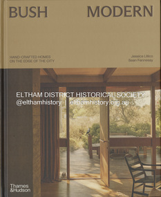
Book, Jessica Lillico, Bush Modern: Hand-crafted homes on the edge of the city, 4 Nov. 2025
... ...River Bend...Contents: Bush modern locations (map) Grounded in simplicity by Jessica Lillico and Sean Fennessy Time and place by Morag Fraser Houses featured - Stonygrad 1940, North Warrandyte Fraser-Jackson House 1947/1977, Montmorency Busst House 1948, Eltham Burstall House 1950, Montmorency Wright House II 1960, North Warrandyte Collis House 1966, Eltham Diskin House 1967, Eltham Redfern House 1967, North Warrandyte River Bend 1968/2022, Garambi Baan, Eltham Fisher House 1969, Warrandyte Borrack House 1970, Plenty Valley Fiddlers Elbow 1970, North Warrandyte Light Well House 1972, Donvale Birrarung House 1974, Garambi Baan, Eltham High Noon 1974, North Warrandyte Monty Sibbel 1975/2022, Montmorency Provan House 1976/2021, North Warrandyte Pizzey House 1977, Eltham Pittard House 1978, Eltham Gray House 1980, Eltham Carol Ann House 1989, Bend of Islands Wattle Glen 1999, Wattle Glen Big Hill 2001, Christmas Hills ...Contents: Bush modern locations (map) Grounded in simplicity by Jessica Lillico and Sean Fennessy Time and place by Morag Fraser Houses featured - Stonygrad 1940, North Warrandyte Fraser-Jackson House 1947/1977, Montmorency Busst House 1948, Eltham Burstall House 1950, Montmorency Wright House II 1960, North Warrandyte Collis House 1966, Eltham Diskin House 1967, Eltham Redfern House 1967, North Warrandyte River Bend 1968/2022, Garambi Baan, Eltham Fisher House 1969, Warrandyte Borrack House 1970, Plenty Valley Fiddlers Elbow 1970, North Warrandyte Light Well House 1972, Donvale Birrarung House 1974, Garambi Baan, Eltham High Noon 1974, North Warrandyte Monty Sibbel 1975/2022, Montmorency Provan House 1976/2021, North Warrandyte Pizzey House 1977, Eltham Pittard House 1978, Eltham Gray House 1980, Eltham Carol Ann House 1989, Bend of Islands Wattle Glen 1999, Wattle Glen Big Hill 2001, Christmas Hills Stonygrad Fraser-Jackson House Busst House Burstall House Wright House II Collis House Diskin House Redfern House River Bend Fisher House Borrack House Fiddlers Elbow Light Well House Birrarung House High Noon Monty Sibbel Provan House Pizzey House Pittard House Gray House Carol Ann House Wattle Glen Big Hill Inside front cover in ink: "Enjoy! ...From the publisher Thames & Hudson Australia's website: "In the bushy north-eastern fringe of Melbourne, an enduring, uniquely Australian architectural aesthetic has been quietly gaining recognition. Emerging out of necessity in the post-war years, it reimagined the sleek ideals of modernism through the lens of the local landscape. Simple homes built 'of the land' from mud bricks and recycled timber captured the mood of those searching for an alternative way of life close to nature. The movement gathered momentum in the counter-cultural 1960s and culminated in near-mainstream popularity in the 1970s. After a few decades where brown lost appeal in favour of white-washed minimalism, the style in all its warm, earthy glory is once again being embraced and revived by a new generation Through evocative photography by Sean Fennessy, personal stories and architectural insights, Bush Modern explores the timeless appeal of these character-filled homes: tactile, grounded and deeply in tune with their environment." Contents: Bush modern locations (map) Grounded in simplicity by Jessica Lillico and Sean Fennessy Time and place by Morag Fraser Houses featured - Stonygrad 1940, North Warrandyte Fraser-Jackson House 1947/1977, Montmorency Busst House 1948, Eltham Burstall House 1950, Montmorency Wright House II 1960, North Warrandyte Collis House 1966, Eltham Diskin House 1967, Eltham Redfern House 1967, North Warrandyte River Bend 1968/2022, Garambi Baan, Eltham Fisher House 1969, Warrandyte Borrack House 1970, Plenty Valley Fiddlers Elbow 1970, North Warrandyte Light Well House 1972, Donvale Birrarung House 1974, Garambi Baan, Eltham High Noon 1974, North Warrandyte Monty Sibbel 1975/2022, Montmorency Provan House 1976/2021, North Warrandyte Pizzey House 1977, Eltham Pittard House 1978, Eltham Gray House 1980, Eltham Carol Ann House 1989, Bend of Islands Wattle Glen 1999, Wattle Glen Big Hill 2001, Christmas Hills Inside front cover in ink: "Enjoy! Jess & Sean"stonygrad, fraser-jackson house, busst house, burstall house, wright house ii, collis house, diskin house, redfern house, river bend, fisher house, borrack house, fiddlers elbow, light well house, birrarung house, high noon, monty sibbel, provan house, pizzey house, pittard house, gray house, carol ann house, wattle glen, big hill -
 Sunbury Family History and Heritage Society Inc.
Postcard, SUNBURY BATHS
... A non-digital sepia photograph in post card format of river bend and small sandy beach on the bank....The Nook Swimming A non-digital sepia photograph in post card format of river bend and small sandy beach on the bank. ...The scene featured on the post card is a view of The Nook on the Jacksons Creek. For many years before the Aquatic Centre was build in the town, The Nook was the swimming place for local residents. The surrounding area had seats and change rooms. The Sunbury Swimming club was established at this site before the Aquatic Centre was built.A non-digital sepia photograph in post card format of river bend and small sandy beach on the bank.the nook, swimming -
 Orbost & District Historical Society
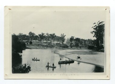
black and white photograph, early 20th century
... A small black / white photograph of two canoes on a river bend. There is a small masted boat. In the canoes and boat are some men.On the bank is a horse and rider....This is a pictorial record of the Snowy River in the early 20th century. indecipherable inscription at bottom front A small black / white photograph of two canoes on a river bend. There is a small masted boat. In the canoes and boat are some men.On the bank is a horse and rider. black and white photograph ...This is probably a view of Orbost on the Snowy River.This is a pictorial record of the Snowy River in the early 20th century.A small black / white photograph of two canoes on a river bend. There is a small masted boat. In the canoes and boat are some men.On the bank is a horse and rider.indecipherable inscription at bottom front -
 Hume City Civic Collection
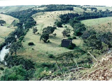
Photograph
... The ruins of a stone building are on the river bend. A damaged fence and prickly pears are in the foreground....The ruins of a stone building are on the river bend. A damaged fence and prickly pears are in the foreground. ...Lochton Flour Mill was established in the 1850s and is only one of a few surviving mills in Victoria. It is situated on a horseshoe bend on the Deep Creek at Bulla.A coloured photograph of a horse shoe bend in a river and the open flood plain. The river is tree-lined. The ruins of a stone building are on the river bend. A damaged fence and prickly pears are in the foreground.lochton mill, deep creek, hunter, william morrison, george evans collection -
 Bendigo Historical Society Inc.
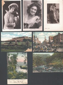
Postcard - WES HARRY COLLECTION: 7 POSTCARDS, 1905 - 09
... bend... River Yarra...(a) Miss Billie Bourke, (b) Carrie Moore, © Miss Carrie Moore as 'Honour in' Tom Jones ', (d) Bourke street on 8 hours day, Melbourne Victoria, (coloured) (e) Fairy Bend, River Yarra, Warburton (colour) (f) Werribee Gorge near Bacchus Marsh Victoria (colour) (g) Lawn Gardens, Flemington, Melbourne (colour)....POSTCARD Photograph various themes Billie Bourke Carrie Moore Actresses Theatre Melbourne Flemington Werribee Gorge Bacchus Marsh Fairy bend River Yarra Warburton Bourke Street 8 hours day Group of seven postcards, three of them depict actresses and four are of various scenes around Victoria. ...Group of seven postcards, three of them depict actresses and four are of various scenes around Victoria. (a) Miss Billie Bourke, (b) Carrie Moore, © Miss Carrie Moore as 'Honour in' Tom Jones ', (d) Bourke street on 8 hours day, Melbourne Victoria, (coloured) (e) Fairy Bend, River Yarra, Warburton (colour) (f) Werribee Gorge near Bacchus Marsh Victoria (colour) (g) Lawn Gardens, Flemington, Melbourne (colour).postcard, photograph, various themes, billie bourke, carrie moore, actresses, theatre, melbourne, flemington, werribee gorge, bacchus marsh, fairy bend, river yarra, warburton, bourke street, 8 hours day -
 Merbein District Historical Society
Photograph, Cowanna Bend cutoff towards Coomealla Crosbies, c.1950
... River... Cowanna Bend cutoff...Merbein District Historical Society 36 Box St Merbein the-murray Murray River Cowanna Bend cutoff Coomealla Crosbies Cowanna Bend cutoff towards Coomealla Crosbies Photograph ...murray river, cowanna bend cutoff, coomealla crosbies -
 Merbein District Historical Society
Photograph, Cowanna Bend cutoff towards Coomealla Crosbies, unknown
... River... Cowanna Bend cutoff...Merbein District Historical Society 36 Box St Merbein the-murray Murray River Cowanna Bend cutoff Coomealla Crosbies Cowanna Bend cutoff towards Coomealla Crosbies Photograph ...murray river, cowanna bend cutoff, coomealla crosbies -
 Merbein District Historical Society
Photograph, Cowanna Bend cutoff towards Coomealla 1950, unknown
... River... Cowanna Bend cutoff...Merbein District Historical Society 36 Box St Merbein the-murray Murray River Cowanna Bend cutoff Coomealla Cowanna Bend cutoff towards Coomealla 1950 Photograph ...murray river, cowanna bend cutoff, coomealla -
 Merbein District Historical Society
Photograph, Cowanna Bend cutoff towards Merbein, unknown
... River... Cowanna Bend cutoff...Merbein District Historical Society 36 Box St Merbein the-murray Murray River Cowanna Bend cutoff Coomealla Crosbies Cowanna Bend cutoff towards Merbein Photograph ...murray river, cowanna bend cutoff, coomealla crosbies -
 Port Melbourne Historical & Preservation Society
Photograph - Rotten Row - Fishermans Bend, 29 Jan 2026
... River...Fishermans Bend...Rotten Row Rotten Row Yarra River Fishermans Bend Melbourne Harbor Trust - Port of Melbourne Authority Rotten Row at Fishemans Bend Photograph Rotten Row - Fishermans Bend ...Rotten Row Rotten Row at Fishemans Bendrotten row, yarra river, fishermans bend, melbourne harbor trust - port of melbourne authority -
 Nillumbik Shire Council
Painting: Guy STUART (b.1942 ACT), Guy Stuart, Tunnel by the Yarra, 2004
... An abstract painting of the Yarra River from Pound Bend in Warrandyte. The painting is quite expressive, linear and gestural in style. ...Nillumbik Shire Council melbourne An abstract painting of the Yarra River from Pound Bend in Warrandyte. The painting is quite expressive, linear and gestural in style. ...An abstract painting of the Yarra River from Pound Bend in Warrandyte. The painting is quite expressive, linear and gestural in style. Muted, neutral tones of greens, browns and reds. -
 Lakes Entrance Historical Society
Postcard - Nicholson River, Bulmer and Segenberg Bairnsdale, 1910
... Also a second black and white postcard showing two rowboats on river at wide bend 05350.1 8.5 x 13.5 cm...Lakes Entrance Historical Society 4 Marine Parade Lakes Entrance gippsland Also a second black and white postcard showing two rowboats on river at wide bend 05350.1 8.5 x 13.5 cm Waterways Boats and Boating Nicholson River Black and white postcard showing view of Upper Nicholson River with three women shown, water level low Nicholson Victoria Postcard Nicholson River Bulmer and Segenberg Bairnsdale ...Also a second black and white postcard showing two rowboats on river at wide bend 05350.1 8.5 x 13.5 cmBlack and white postcard showing view of Upper Nicholson River with three women shown, water level low Nicholson VictoriaNicholson River waterways, boats and boating -
 Lakes Entrance Historical Society
Photograph - Mitchell River, Glenaladale Victoria, 1994 c
... Colour photograph of Mitchell River from Billy Goat Bend showing steep gorge between heavily forested high banks. ...Lakes Entrance Historical Society 4 Marine Parade Lakes Entrance gippsland Topography Rivers Colour photograph of Mitchell River from Billy Goat Bend showing steep gorge between heavily forested high banks. ...Colour photograph of Mitchell River from Billy Goat Bend showing steep gorge between heavily forested high banks. Glenaladale Victoria. Also two photographs of U3A Geology group on track overlooking Mitchell River and black and white photograph of Billy Goat Bend donated by Lakes Post Newspaper 6 January 2010 topography, rivers -
 Eltham District Historical Society Inc
Photograph - Digital Photograph, Jim Connor, Birrarung House, 195 Laughing Waters Road, Eltham, 7 September 2013
... On the way we visited the two artist in residence properties, River Bend and Birrarung, to view the houses on them that are associated with Alistair Knox, Gordon Ford and others in the local mud brick and artistic community. ...On the way we visited the two artist in residence properties, River Bend and Birrarung, to view the houses on them that are associated with Alistair Knox, Gordon Ford and others in the local mud brick and artistic community. ...Laughing Waters Walk, 7 Sep 2013 This Society excursion was a follow up to the Laughing Waters Story told to us by Jane Woollard at our Annual General Meeting in March 2013. It involved a walk commencing from the corner of Laughing Waters and Overbank Roads along Laughing Waters Road to its eastern end and returning partly over the same route - a total distance of about 2.5km. On the way we visited the two artist in residence properties, River Bend and Birrarung, to view the houses on them that are associated with Alistair Knox, Gordon Ford and others in the local mud brick and artistic community. We also able to walk around the derelict ruin which was once home to Gordon and Sue Ford, Boomerang House. An unexpected afternoon tea was offered to us by the artists in residence at Birrarung House and we had a brief opportunity to view inside the house. Birrarung is situated near the end of Laughing Waters Road. It was built in 1974 by Graeme Rose for Gordon Ford who he had asked to build him a small ‘bach’. Builder Peter Jarvis who did his apprenticeship with Alistair Knox for a couple of years recalled there were no drawings. It evolved as more funds became available. Graeme would source second-hand building materials around which he would shape the house. The fireplace was built with chicken wire over which it was rendered with faro cement. A brick floored glass studio, added later, faces a wall of boulders pressed into a manmade cliff, a large pond the link between the rock wall and glass studio. A waterfall, fed by river water, no longer functions. The property became part of the Laughing Waters Artist in Residency Program with the first artist taking up residency in 2001. For a more in-depth description of the property and biographies of the various artists in residence commencing from 2001 through to 2015, see Jane Woollard's book, "Laughing Waters Road; Art, Landscape & Memory in Eltham" published 2016.2013-09-07, activities, artists in residence, eltham district historical society, heritage excursion, jim connor collection, laughing waters road, birrarung house -
 Eltham District Historical Society Inc
Photograph, Fay Bridge, Birrarung House, 195 Laughing Waters Road, Eltham, 7 September 2013
... On the way we visited the two artist in residence properties, River Bend and Birrarung, to view the houses on them that are associated with Alistair Knox, Gordon Ford and others in the local mud brick and artistic community. ...On the way we visited the two artist in residence properties, River Bend and Birrarung, to view the houses on them that are associated with Alistair Knox, Gordon Ford and others in the local mud brick and artistic community. ...Laughing Waters Walk, 7 Sep 2013 This Society excursion was a follow up to the Laughing Waters Story told to us by Jane Woollard at our Annual General Meeting in March 2013. It involved a walk commencing from the corner of Laughing Waters and Overbank Roads along Laughing Waters Road to its eastern end and returning partly over the same route - a total distance of about 2.5km. On the way we visited the two artist in residence properties, River Bend and Birrarung, to view the houses on them that are associated with Alistair Knox, Gordon Ford and others in the local mud brick and artistic community. We also able to walk around the derelict ruin which was once home to Gordon and Sue Ford, Boomerang House. An unexpected afternoon tea was offered to us by the artists in residence at Birrarung House and we had a brief opportunity to view inside the house. Birrarung is situated near the end of Laughing Waters Road. It was built in 1974 by Graeme Rose for Gordon Ford who he had asked to build him a small ‘bach’. Builder Peter Jarvis who did his apprenticeship with Alistair Knox for a couple of years recalled there were no drawings. It evolved as more funds became available. Graeme would source second-hand building materials around which he would shape the house. The fireplace was built with chicken wire over which it was rendered with faro cement. A brick floored glass studio, added later, faces a wall of boulders pressed into a manmade cliff, a large pond the link between the rock wall and glass studio. A waterfall, fed by river water, no longer functions. The property became part of the Laughing Waters Artist in Residency Program with the first artist taking up residency in 2001. For a more in-depth description of the property and biographies of the various artists in residence commencing from 2001 through to 2015, see Jane Woollard's book, "Laughing Waters Road; Art, Landscape & Memory in Eltham" published 2016.2013-09-07, activities, artists in residence, eltham district historical society, heritage excursion, laughing waters road, birrarung house, fay bridge collection -
 Eltham District Historical Society Inc
Photograph - Digital Photograph, Jim Connor, Boomerang House, 195 Laughing Waters Road, Eltham, 7 September 2013
... On the way we visited the two artist in residence properties, River Bend and Birrarung, to view the houses on them that are associated with Alistair Knox, Gordon Ford and others in the local mud brick and artistic community. ...On the way we visited the two artist in residence properties, River Bend and Birrarung, to view the houses on them that are associated with Alistair Knox, Gordon Ford and others in the local mud brick and artistic community. ...Laughing Waters Walk, 7 Sep 2013 This Society excursion was a follow up to the Laughing Waters Story told to us by Jane Woollard at our Annual General Meeting in March 2013. It involved a walk commencing from the corner of Laughing Waters and Overbank Roads along Laughing Waters Road to its eastern end and returning partly over the same route - a total distance of about 2.5km. On the way we visited the two artist in residence properties, River Bend and Birrarung, to view the houses on them that are associated with Alistair Knox, Gordon Ford and others in the local mud brick and artistic community. We also able to walk around the derelict ruin which was once home to Gordon and Sue Ford, Boomerang House. An unexpected afternoon tea was offered to us by the artists in residence at Birrarung House and we had a brief opportunity to view inside the house. Gordon Ford and photographer Sue Winslow were married in 1965. They set up home in an old log cabin on the property Gordon had purchased in 1954 on Laughing Waters Road. Situated between the Yarra River and Overbank Road, Gordon had built a small mud-brick shack on the river and a pontoon. Over the decades the shack has been locally referred to as “the love shack”, the “rooting shack” or simply “Gordon’s shack”. Gordon and Sue commissioned local builder Graeme Rose to do a wattle and daub renovation and extension to the old log cabin on the north side of Laughing Waters Road. The work had only just been completed in 1965 when a bushfire swept through the area and destroyed the cabin. Gordon and Sue relocated to his property, Fulling, in Pitt Street, Eltham. In 1970 work started on a new house at the Laughing Waters property. Originally known as the Banana House, it is now known as Boomerang. Designed by Alistair Knox, the mud-brick house includes iron window grilles made by Matcham Skipper that puncture the curved mud walls. The grilles were made from ‘off-pressings’ from the Sidchrome tool works in Heidelberg. Gordon, Sue and family moved into the house in 1972. Their marriage fell apart and Sue moved to Sydney with the children around the same time Gordon commenced building Birrarung just below Boomerang on the Laughing Waters Road block. After the Fords moved out, Boomerang it was rented out to various share households of students, musicians, artists and environmentalists for twenty-four years. Gordon Ford sold Birrarung and Boomerang to Melbourne Water in 1999. The Laughing Waters Artist in Residence Program was developed as a partnership between Parks Victoria and Nillumbik Shire Council. Boomerang was deemed unfit for habitation so was used as a day studio only. By 2001 Boomerang was in a poor state of repair and by 2002 the last artist in residence was to use the house as a studio. Nillumbik Shire Council had been granted funds from the Melbourne Community Fund to restore both Boomerang and Birrarung but it was apparent in early 2003 that the funds would be insufficient to restore both houses. Boomerang was infested with termites which presented a risk to any occupants and so the decision was made to close Boomerang and concentrate funding on Birrarung. Boomerang was fenced off for safety and to prevent intrusion and remains ‘caged’ today (2023). However, it is readily apparent the property has been occupied by squatters over the years. By 2023 it was clear that the squatters had abandoned the property and sections of the roof structure have given away in some areas and collapsed internally. For a more in-depth description and history of the property and that of Gordon and Sue Ford, see Jane Woollard's book, "Laughing Waters Road; Art, Landscape & Memory in Eltham" published 2016.2013-09-07, activities, eltham district historical society, heritage excursion, jim connor collection, laughing waters road, boomerang house, gordon ford -
 Eltham District Historical Society Inc
Photograph - Digital Photograph, Jim Connor, The Love Shack, 195 Laughing Waters Road, Eltham, 7 September 2013
... On the way we visited the two artist in residence properties, River Bend and Birrarung, to view the houses on them that are associated with Alistair Knox, Gordon Ford and others in the local mud brick and artistic community. ...On the way we visited the two artist in residence properties, River Bend and Birrarung, to view the houses on them that are associated with Alistair Knox, Gordon Ford and others in the local mud brick and artistic community. ...Laughing Waters Walk, 7 Sep 2013 This Society excursion was a follow up to the Laughing Waters Story told to us by Jane Woollard at our Annual General Meeting in March 2013. It involved a walk commencing from the corner of Laughing Waters and Overbank Roads along Laughing Waters Road to its eastern end and returning partly over the same route - a total distance of about 2.5km. On the way we visited the two artist in residence properties, River Bend and Birrarung, to view the houses on them that are associated with Alistair Knox, Gordon Ford and others in the local mud brick and artistic community. We also able to walk around the derelict ruin which was once home to Gordon and Sue Ford, Boomerang House. An unexpected afternoon tea was offered to us by the artists in residence at Birrarung House and we had a brief opportunity to view inside the house. Gordon Ford and photographer Sue Winslow were married in 1965. They set up home in an old log cabin on the property Gordon had purchased in 1954 on Laughing Waters Road. Situated between the Yarra River and Overbank Road, Gordon had built a small mud-brick shack on the river and a pontoon. Over the decades the shack has been locally referred to as “the love shack”, the “rooting shack” or simply “Gordon’s shack”. Gordon and Sue commissioned local builder Graeme Rose to do a wattle and daub renovation and extension to the old log cabin on the north side of Laughing Waters Road. The work had only just been completed in 1965 when a bushfire swept through the area and destroyed the cabin. Gordon and Sue relocated to his property, Fulling, in Pitt Street, Eltham. In 1970 work started on a new house at the Laughing Waters property. Originally known as the Banana House, it is now known as Boomerang. Designed by Alistair Knox, the mud-brick house includes iron window grilles made by Matcham Skipper that puncture the curved mud walls. The grilles were made from ‘off-pressings’ from the Sidchrome tool works in Heidelberg. Gordon, Sue and family moved into the house in 1972. Their marriage fell apart and Sue moved to Sydney with the children around the same time Gordon commenced building Birrarung just below Boomerang on the Laughing Waters Road block. After the Fords moved out, Boomerang it was rented out to various share households of students, musicians, artists and environmentalists for twenty-four years. Gordon Ford sold Birrarung and Boomerang to Melbourne Water in 1999. The Laughing Waters Artist in Residence Program was developed as a partnership between Parks Victoria and Nillumbik Shire Council. Boomerang was deemed unfit for habitation so was used as a day studio only. By 2001 Boomerang was in a poor state of repair and by 2002 the last artist in residence was to use the house as a studio. Nillumbik Shire Council had been granted funds from the Melbourne Community Fund to restore both Boomerang and Birrarung but it was apparent in early 2003 that the funds would be insufficient to restore both houses. Boomerang was infested with termites which presented a risk to any occupants and so the decision was made to close Boomerang and concentrate funding on Birrarung. Boomerang was fenced off for safety and to prevent intrusion and remains ‘caged’ today (2023). However, it is readily apparent the property has been occupied by squatters over the years. By 2023 it was clear that the squatters had abandoned the property and sections of the roof structure have given away in some areas and collapsed internally. For a more in-depth description and history of the property and that of Gordon and Sue Ford, see Jane Woollard's book, "Laughing Waters Road; Art, Landscape & Memory in Eltham" published 2016.2013-09-07, activities, eltham district historical society, heritage excursion, jim connor collection, laughing waters road, boomerang house, gordon ford, gordon's shack, love shack -
 Eltham District Historical Society Inc
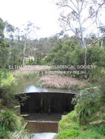
Photograph - Digital Photograph, Marguerite Marshall, Smith Dam, Karingal Drive, Eltham, 19 September 2006
... The Smiths named it Nerreman Park using the Aboriginal word Nerreman meaning ‘River Bend’ as their creek had a pronounced bend.2 In 1940 the first thing Bernie did was to build a dam, and with Isa’s help, a pump-house, to secure a water supply for their cattle, pigs, chickens, orchard and vegetable gardens. ...The Smiths named it Nerreman Park using the Aboriginal word Nerreman meaning ‘River Bend’ as their creek had a pronounced bend.2 In 1940 the first thing Bernie did was to build a dam, and with Isa’s help, a pump-house, to secure a water supply for their cattle, pigs, chickens, orchard and vegetable gardens. ...The dam at the entrance to the Nerreman Gateway in Eltham was built according to an internationally acclaimed theory developed by the builder's father. In 1920, Victorian engineer B.A. Smith was awarded the American Society of Civil Engineers J. James R. Cross Gold Medal for his Technical Paper titled 'Arched Dams'. It was the first time this medal had been awarded outside the United States. The concrete arched dam across the Eltham West Drain was built in 1940 by B.A. Smith's son and engineer, D. B. (Bernie) Smith to water the 24 acre (9.75 ha) hobby farm owned by himself and new wife, Isa Smith. Upon completion of the dam a pump-house was constructed beside the creek but before the water could be pumped up the hill they had to dig a trench and lay 500m of 100mm water main to an elevated holding tank. The Smiths made the pump-house their home for several years until they constructed their home at the top of the hill overlooking Eltham and views extending to Kinglake. Following Bernie's death in 1983, Nerreman Park was subdivided between 1993 and 1995. Gordon Ford designed the landscaping and the pump-house was demolished. Covered under Heritage Overlay, Nillumbik Planning Scheme. Published: Nillumbik Now and Then / Marguerite Marshall 2008; photographs Alan King with Marguerite Marshall.; p137 The dam at the entrance to the Nerreman Gateway in Eltham, was built according to an internationally acclaimed theory developed by the builder’s father. In 1920, Victorian engineer B A Smith was awarded the American Society of Civil Engineers J. James R. Croes Gold Medal, for his Technical Paper titled Arched Dams. It was the first time this medal had been awarded outside America. An international example of the application of Smith’s work can be found in the design of the Hoover Dam on the Colorado River, Nevada, USA. Built between 1930 and 1936, it is recognised by the ASCE as one of ‘America’s Seven Modern Civil Engineering Wonders’.1 The concrete arched dam across the Eltham West Drain was built by B A Smith’s son and engineer, D B (Bernie) Smith. Bernie’s dam followed his father’s theory, having a curvature that takes maximum advantage of concrete’s great strength in compression. The water load is carried into the abutments because of this curvature, which permits a wall thickness of only 225 millimetres thick at its crest, despite the dam’s capacity of more than 4.5 megalitres. The Eltham dam was designed to water the 24 acre (9.75 ha) hobby farm belonging to newly married couple Bernie and Isa Smith. Bernie, from Armadale, and Isa, from a farm at Tyntynder near Swan Hill, were attracted to the hilly topography and the creek running through the property. It extended from Ryans Road, Eltham, to Karingal Drive, Montmorency and was adjacent to Meruka Park. The Smiths named it Nerreman Park using the Aboriginal word Nerreman meaning ‘River Bend’ as their creek had a pronounced bend.2 In 1940 the first thing Bernie did was to build a dam, and with Isa’s help, a pump-house, to secure a water supply for their cattle, pigs, chickens, orchard and vegetable gardens. It was also available for the fire-plugs, which they placed all over the property in case of bushfire. The couple built the pump-house beside the creek and installed a Tange three-plunger pump, which had originally supplied the City of Wodonga with water. But before the Smiths could pump water up the hill from the dam they had to dig a trench and lay about 550 yards (500m) of a four-inch (100mm) water main up to an elevated holding tank. The trench was dug with a single furrow plough drawn by an old draught horse. Living in rough conditions did not deter the Smiths, who made the pump-house their home, where they still lived when their first child was born in 1944. They later built their home at the top of their property overlooking Eltham, with magnificent views to Kinglake, the Dandenong Ranges and Melbourne. From 1946 it took them almost 20 years to complete the 36-square house with its 12-foot (3.6m) high ceilings. Material for the concrete roof and walls faced with sandstone, was ripped out of the ground on their property by plough pulled by tandem Clydesdale horses. Isa was a strong woman – two days before their second child was born – she set three huge sandstone boulders in place in the bottom wall of the garage. She also mixed all the cement for the house. A collapsed kitchen wall did not discourage her from rebuilding it in a week, while her husband was away working in the country. She later recalled: ‘We stood back to admire this beautiful wall we’d built and while we were looking at it, it came tumbling down’.3 Following Bernie’s death in 1983, Nerreman Park was subdivided, between 1993 and 1995. Local Gordon Ford designed the landscaping and the pump-house was pulled down. But the dam remains as a reminder of exceptional engineering4 – and of a remarkable couple.This collection of almost 130 photos about places and people within the Shire of Nillumbik, an urban and rural municipality in Melbourne's north, contributes to an understanding of the history of the Shire. Published in 2008 immediately prior to the Black Saturday bushfires of February 7, 2009, it documents sites that were impacted, and in some cases destroyed by the fires. It includes photographs taken especially for the publication, creating a unique time capsule representing the Shire in the early 21st century. It remains the most recent comprehenesive publication devoted to the Shire's history connecting local residents to the past. nillumbik now and then (marshall-king) collection, eltham, karingal drive, smiths dam, bernie smith, gordon ford, isa smith, nerreman gateway, nerreman park estate, dams -
 Ringwood and District Historical Society
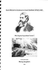
Book, David Mitchell at Anderson's Creek Goldfield, 1870-1887 - Who Dug the Pound Bend Tunnel?, 2004
... Campbell mentions that "In 1890 (sic) Mitchell formed a company to mine a channel and tunnel on the Yarra River at Pound Bend, Warrandyte," i.e., at a period some 18 or so years after it is known that the Evelyn Tunnel Gold-Mining Company had actually ceased operations. ...Campbell mentions that "In 1890 (sic) Mitchell formed a company to mine a channel and tunnel on the Yarra River at Pound Bend, Warrandyte," i.e., at a period some 18 or so years after it is known that the Evelyn Tunnel Gold-Mining Company had actually ceased operations. ...Suggested reading - David Mitchell, A Forfar Man - Pamela Vestey. (National Library of Australia ISBN No. 0646104977 Second edition - 1996.A discussion paper by Murray Houghton, Warrandyte Historical Society, on the excavation of Pound Bend tunnel and examination of information sources suggesting David Mitchell's association with gold mining at Warrandyte." ... Just what then was Mitchell's actual association with mining in the Anderson's Creek goldfield? As an initial means to determining this, a number of biographies devoted to the man's lifetime achievements have been consulted. Some two of these were found to contain rather brief references to his involvement at Warrandyte. In the 1992 booklet entitled "David Mitchell a Forfar Man" written by a Mitchell family member, viz., Pamela, Lady Vestey, of Coombe Cottage, there is included a passge which commences "Another of David Mitchell's early interests was gold mining". This is appended by the bald statement "In 1870 he formed the Evelyn Tunnel Gold-Mining Company with a capital of £16,000." The other account of a Mitchell involvement with an unnamed Warrandyte company is contained in Joan Campbell's 1974 biographical article entitled, "Mitchell, David (1829- 1916) builder, contractor and businessman, etc.", in Volume 5 of the "Australian Dictionary of Biogaraphy". Campbell mentions that "In 1890 (sic) Mitchell formed a company to mine a channel and tunnel on the Yarra River at Pound Bend, Warrandyte," i.e., at a period some 18 or so years after it is known that the Evelyn Tunnel Gold-Mining Company had actually ceased operations. She then continues with the bizarre statement that "he employed gangs of Chinese to work three miles of river bed for gold". Neither of these respective excerpts indicate evidence of having been directly referenced from a legitimate original source, from which either author's contained comments might be authenticated. For any historian with an enquiring mind these statements demand further clarification. ..." - Murray Houghton -
 Eltham District Historical Society Inc
Photograph, Fay Bridge, Former Glynn's Dairy Farm, Glynns Road, North Warrandyte, 31 August 2018
... A private swing bridge crossed the river at Pound Bend was known as Pearson’s bridge after C.W.K. ...A private swing bridge crossed the river at Pound Bend was known as Pearson’s bridge after C.W.K. ...Glynn’s farm Originally Section 7, Parish of Nillumbik marked Aborigine Reserve in 1866 Crown Allotment 8, Section 7, Parish of Nillumbik, County of Evelyn, Certificate of Title Volume 4095, Folio 818.835, approx. 93 acres purchased by Joseph Panton in 1881 for £1/acre and known as Panton’s Point. By 1924 owned by S.S. Sergeant and called Riverswood. Sergeant commissioned Edna Walling to design the garden. In September 1929 the property was sold at auction by Mortgagee’s sale. Described as well built, brick, tile roof, Attic Villa containing downstairs 7 good rooms, bath, scullery, inside lavatory, etc. Upstairs 2 bedrooms and sleep out. Outbuildings compromising of brick and weatherboard wash house, stables, workshop, feed room, cow bails, large G.I. Hay shed, etc In January 1931 Riverswood property was proclaimed a sanctuary for native game for the entire year. A private swing bridge crossed the river at Pound Bend was known as Pearson’s bridge after C.W.K. Pearson who bought Riverswood in the early 1930s. The bridge was swept away in the December 1934 floods. Riverswood was sold by C.W.K. Pearson at auction on 25 November 1936. Described as a beautiful farm home of 93 acres and over one mile of River Yarra frontage, modern brick residence, lovely garden, rich river flat pastures, model poultry farm. The fine brick home was destroyed on Black Friday (13 Jan.) 1939. It was still a ruin when the Evelyn Evans purchased Waikowhane above Riverswood in 1940. The Glynn family purchased the Riverswood property in 1941 from Robert and Emily Hannon. Their son Kenneth Patrick Glynn inherited the property and he set about clearing the land during WW2 selling wood. Prior to marriage, Kenneth was living alone on the farm in a house he had built from whatever was available. He used the bluestone foundations from the original fine brick home. He met and married Honora Elizabeth Drew in early 1945 and their daughter Anna grew up on the farm. It was compulsorily acquired by the Board of Works in 1976 who then rented the house out in the 1980s. The property was transferred to Melbourne Parks and Waterways in 1996. Waikowhane was a pretty timber house built on top of the hill on 50 acres above Riverswood by retired nurse Jessie MacBeth. (This would be at the intersection of Glynns Road and Overbank Road where the big water tank is now situated on what was once James Orford’s property.) It was also destroyed Black Friday and she rebuilt it from the plans living in a caravan on site supervising the build. It was almost complete when she died May 1939. The property was bought by Evelyn Evans (a city girl) and her estranged husband in 1940. She had two sons, one only 9 months old at the time. It was a timber house with no power or water connected. The Ewen Cameron family bought Waikowhane in 1957. They had to evacuate when the 1961 bushfires swept through. The house was saved by Matcham Skipper. It was demolished by Melbourne Water in the 1990s when they acquired it.fay bridge collection, 2018-08-31, glynn's, glynn's dairy farm, glynns road, north warrandyte, parks victoria, ruins, riverswood, kenneth patrick glynn -
 Warrnambool and District Historical Society Inc.
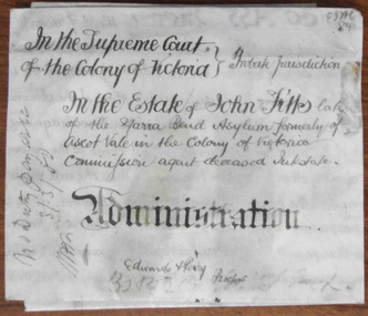
Document - John Fitts Letters of Administration 1879, 1879
... Yarra Bend Asylum, near the junction of the Yarra River and the Merri Creek was the first institution for the mentally ill in Victoria and operated from 1848 to 1925. ...Yarra Bend Asylum, near the junction of the Yarra River and the Merri Creek was the first institution for the mentally ill in Victoria and operated from 1848 to 1925. ...No information has been found on the Commission Agent John Fitts except that he died at the Yarra Bend Asylum at the age of 51 and was formerly a resident of Ascot Vale, a suburb of Melbourne. His estate was valued at £600. Yarra Bend Asylum, near the junction of the Yarra River and the Merri Creek was the first institution for the mentally ill in Victoria and operated from 1848 to 1925. Tait collection: item 5 of 62This document is only of interest in that it came from the former legal offices of Mackay Taylor in Kepler Street, Warrnambool. It originally came from Thomas Goodall, a legal clerk in the office of the lawyer Ernest Chambers who passed it on to George Mackay, the lawyer in the forerunner firm of Mackay Taylor where it remained until the firm of Mackay Taylor ceased to exist and the buildings were cleaned out. This is a piece of parchment paper with printed black lines and handwritten material in black ink. There is a fold at the bottom of the document with a seal of the Supreme Court of the Colony of Victoria attached by a green ribbon. The document is slightly discoloured but is otherwise in good condition. ‘In the Supreme Court of the Colony of Victoria, Probate jurisdiction, In the Estate of John Fitts, late of the Yarra Bend Asylum, formerly of Ascot Vale in the Colony of Victoria, commission agent, deceased intestate, Administration, Edwards and Perry, Proctors’yarra bend asylum, john fitts, warrnambool -
 Port of Echuca
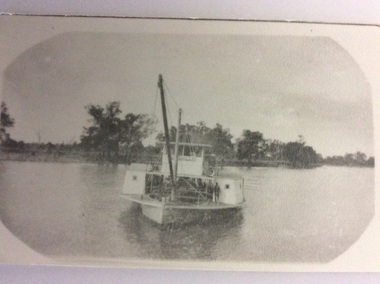
Black & white photograph
... The boats are on a bend in the river. The barge appears to be laden with timber....River In blue pen on reverse of photograph are written the words ? Adelaide (crossed out) Edwards & Ada barge ID4. Geoff Evans ? ( also crossed out). A black & white photograph of the P. S. Edwards towing the barge "Ada". A large tree is in the foreground and frames the boats. The boats are on a bend ...The P. S. Edwards was built in May 1875 by J. M. Webb, Echuca. Official number 73287, made of wood, with paddle wheels at the side. 78 gross tons, 27 nett tons. It was altered in 1916 , after cabin removed 48 gross ton. It had 7 different owners before being purchased by R. J. Evans, of Evans Bros. Saw Mill, Echuca, in 1919. The P. S. Edwards was sunk at Echuca in the spring of 1958 and then raised in January 1981 and then was being restored by Geoff Evans in 1985 (Parsons, Ronald. Ships of the Island Rivers. 3rd ed. 1996. p.67) The barge Ada was built in 1899 at Echuca by the Permewan Wright Company. The Ada hull was built of part wood and part steel, to protect the wool from becoming wet on the voyage down the Darling River to the Echuca Wharf. The Ada was used as a logging insider barge as well as a wool barge with the Pevensey on the Darling River.The P. S. Edwards has historical and social significance being a paddle boat built in Echuca. The P. S. Edwards was built in May 1875 by J. M. Webb, Echuca. It had 7 different owners before being purchased by R. J. Evans, of Evans Bros. Saw Mill, Echuca, in 1919. The P. S. Edwards was sunk at Echuca in the spring of 1958 "and as the mill was burnt in 1959 salvage was not attempted. She was raised in January 1981 and in 1985 was restored by Geoff Evans. While owned by Evans Bros, was used to bring red gum from the Barmah Forest to the sawmill in the barge Clyde." (Parsons, Ronald. Ships of the Island Rivers. 3rd ed. 1996. p.67) The barge Ada was significant because of the construction of the hull, being part wood and part steel. The Ada was used as an inside looking barge as well as a wool barge with the P.S Pevensey on the Darling River. The barge Ada is still on display at the slipway at the Port of Echuca. A black & white photograph of the P. S. Edwards towing the barge "Ada". A large tree is in the foreground and frames the boats. The boats are on a bend in the river. The barge appears to be laden with timber.In blue pen on reverse of photograph are written the words ? Adelaide (crossed out) Edwards & Ada barge ID4. Geoff Evans ? ( also crossed out). port of echuca, p. s. edwards, evans bros saw mills, ada barge, wool industry, p.s pevensey, darling river -
 Port of Echuca
Black and white photograph, 1907
... Known as the "Greyhound of the River" after her original engine was substituted with a Railway locomotive, minus the wheels.The speed of the Canally set up tremendous wash, which sank any small craft. In 1929 it was sold to N. Collins who converted it to a barge. The Chislett Brothers were the owners when the P.S Canally sank at Boundary Bend...Known as the "Greyhound of the River" after her original engine was substituted with a Railway locomotive, minus the wheels.The speed of the Canally set up tremendous wash, which sank any small craft. In 1929 it was sold to N. Collins who converted it to a barge. The Chislett Brothers were the owners when the P.S Canally sank at Boundary Bend ...The P.S Canally was built in 1907 by R.W. Beer. Known as the "Greyhound of the River" after her original engine was substituted with a Railway locomotive, minus the wheels.The speed of the Canally set up tremendous wash, which sank any small craft. In 1929 it was sold to N. Collins who converted it to a barge. The Chislett Brothers were the owners when the P.S Canally sank at Boundary Bend in 1962. (Ref . Parsons R. "Ships of the Inland Rivers." P.58.)The P.S.Canally is significant because it was fitted with a locomotive, minus the wheels. This is significant because it shows the need for the paddle steamers to travel fast. This could show the competitiveness of the paddle steamer trade on the river in the early 20th Century. A small black and white photograph of an old photograph of the P.S Canally in the middle of the river. The paddle steamer is travelling towards the camera. p.s canally, beer, r.w., chislett brothers, collins, n.