Showing 3675 items matching "road bridges"
-
 Orbost & District Historical Society
folder, Orbost Bridges - Snowy River Road Bridges, 1974 1976
... Orbost Bridges - Snowy River Road Bridges...In early 1974, as an Engineer with the Country Roads Board, David came to Orbost as the Supervising Engineer for the construction of the new bridges which were part of an 8.4km Orbost bypass road design. ...A white plastic folder - Orbost Bridges - Snowy River Road Bridges. it contains newspaper articles, booklets, photographs and documents relating to the construction of the Snowy River Road Bridge in 1974 -1976....on front cover - 1974 - 76 ORBOST / SNOWY RIVER ROAD BRIDGES * construction * photos * articles * plans Donated by David Jellie Oct 2015...Orbost Bridges - Snowy River Road Bridges folder Jellie, David ...This folder was compiled in October 2015 from documents, magazines. papers and photographs donated by David Jellie, engineer in charge 1974 - 1976. In early 1974, as an Engineer with the Country Roads Board, David came to Orbost as the Supervising Engineer for the construction of the new bridges which were part of an 8.4km Orbost bypass road design. This was a major project involving not only a new bridge over the Snowy River (including Lochiel Lagoon), but other bridges over Ashby’s Gulch and Watt’s Gulch. These new bridges were opened in November 1976 with the unveiling of a plaque on the eastern end of the $2.4M Snowy River Bridge. (ref. May Leatch)This item is a useful reference tool on the construction history of the Snowy River Road bridges.A white plastic folder - Orbost Bridges - Snowy River Road Bridges. it contains newspaper articles, booklets, photographs and documents relating to the construction of the Snowy River Road Bridge in 1974 -1976.on front cover - 1974 - 76 ORBOST / SNOWY RIVER ROAD BRIDGES * construction * photos * articles * plans Donated by David Jellie Oct 2015snowy-river-bridges jellie-david -
 Orbost & District Historical Society
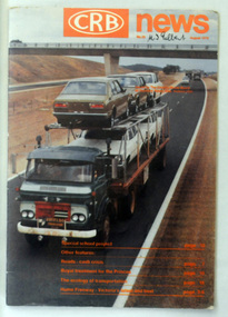
magazine, CRB News, August 1976
... crb-news country-roads-board snowy-river-road-bridges...As a result of these needs the Country Roads Act 1912 was proclaimed in 1913 providing for the establishment of the Country Roads Board as a central road authority with responsibility for those roads within the State considered to be main roads. the C.R.B. was responsible for the construction of roads and bridges including the Snowy River road bridges in Orbost. ...It contains information and photos of the construction of the Snowy River road bridges....May Leatch) This is a useful reference tool on the history of the construction of the Snowy River road bridges. crb-news country-roads-board snowy-river-road-bridges on front cover - handwritten in black - "M. ...By 1910 it had become apparent that there was a need for a central roads authority to take over responsibility from the Board of Lands and Works for the care and management of the main roads of the state of Victoria. Because there was no consistent and systematic policy for road maintenance Victorian roads were in a deplorable condition. At this time the use of the motor car accentuated the demands for better roads. As a result of these needs the Country Roads Act 1912 was proclaimed in 1913 providing for the establishment of the Country Roads Board as a central road authority with responsibility for those roads within the State considered to be main roads. the C.R.B. was responsible for the construction of roads and bridges including the Snowy River road bridges in Orbost. This was a major project involving not only a new bridge over the Snowy River (including Lochiel Lagoon), but other bridges over Ashby’s Gulch and Watt’s Gulch. These new bridges were opened in November 1976 with the unveiling of a plaque on the eastern end of the $2.4M Snowy River Bridge. (ref. May Leatch) This is a useful reference tool on the history of the construction of the Snowy River road bridges.A journal, titled "CRB News" . On the front cover the title is in orange print with No. 33 August 1976 above a coloured photo of a truck carrying two tiers of new vehicles along a main sealed road. It contains information and photos of the construction of the Snowy River road bridges.on front cover - handwritten in black - "M. I. Gilbert"crb-news country-roads-board snowy-river-road-bridges -
 Eltham District Historical Society Inc
Photograph, Flooding of Diamond Creek at Lower Eltham Main Road bridge, Nov 2004, 2004
... Flooding of Diamond Creek at Lower Eltham Main Road bridge, Nov 2004...road...bridges...Two colour photographs of the flooded Diamond Creek at the Lower Eltham Main Road bridge in Nov 2004...Eltham District Historical Society Inc 728 Main Rd Eltham melbourne eltham main road bridges diamond creek floods Two colour photographs of the flooded Diamond Creek at the Lower Eltham Main Road bridge in Nov 2004 Flooding of Diamond Creek at Lower Eltham Main Road bridge, Nov 2004 Photograph Photograph ...Two colour photographs of the flooded Diamond Creek at the Lower Eltham Main Road bridge in Nov 2004eltham, main road, bridges, diamond creek, floods -
 Whitehorse Historical Society Inc.
Photograph, Quarry Road Mitcham, 2006
... road...mitcham...bridges...Coloured photo of Guarry Road bridge near boundary of Whitehorse and Manningham municipalities....Whitehorse Historical Society Inc. 2-10 Deep Creek Road Mitcham melbourne quarry road mitcham bridges Coloured photo of Guarry Road bridge near boundary of Whitehorse and Manningham municipalities. ...Coloured photo of Guarry Road bridge near boundary of Whitehorse and Manningham municipalities.quarry road, mitcham, bridges -
 Hume City Civic Collection
Photograph, c 1980s
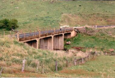
... bridge...wildwood road...The Gillies Bridge is situated on Wildwood Road which runs off Lancefield Road. ...A coloured photograph of a concrete road bridge spanning a small creek. The bridge has four arches. ...It spans the Deep Creek. gillies bridge wildwood road bridges george evans collection A coloured photograph of a concrete road bridge spanning a small creek. ...The Gillies Bridge is situated on Wildwood Road which runs off Lancefield Road. It spans the Deep Creek.A coloured photograph of a concrete road bridge spanning a small creek. The bridge has four arches. Two people are standing above the 4th arch on the roadway. The hillsides on either side of the valley are bare.gillies bridge, wildwood road, bridges, george evans collection -
 Kew Historical Society Inc
Photograph, Burke Road Bridge, 1930s
... Burke Road Bridge...burke road bridge (kew)...Private and public bridges were constructed from the 1850s, beginning with the Hawthorn Bridge linking Bridge and Burwood Roads. A bridge across the Yarra at Burke Road was created as early as 1873. ...Sepia, faded photograph of the Burke Road Bridge linking East Kew and Ivanhoe. The previous bridge, constructed in 1926 was submerged beneath the flood waters in the 1934 mega-flood of the Yarra....Since that first wooden bridge, a number of later bridges, typically on concrete pylons have been built, in 1926 and again during the 1970s. burke road bridge (kew) bridges -- river yarra Sepia, faded photograph of the Burke Road Bridge linking East Kew and Ivanhoe. ...Without bridges, Kew remained cut off from the City of Melbourne, only being accessible by Punt. Private and public bridges were constructed from the 1850s, beginning with the Hawthorn Bridge linking Bridge and Burwood Roads. A bridge across the Yarra at Burke Road was created as early as 1873. Since that first wooden bridge, a number of later bridges, typically on concrete pylons have been built, in 1926 and again during the 1970s.Sepia, faded photograph of the Burke Road Bridge linking East Kew and Ivanhoe. The previous bridge, constructed in 1926 was submerged beneath the flood waters in the 1934 mega-flood of the Yarra.burke road bridge (kew), bridges -- river yarra -
 Whitehorse Historical Society Inc.
Photograph, Quarry Road Bridge, Mitcham, 2007
... Quarry Road Bridge, Mitcham...road...mitcham...bridges...Coloured Photo of Quarry Road Bridge, Mitcham near boundary of Whitehorse Road and Manningham Municipalities. ...Whitehorse Historical Society Inc. 2-10 Deep Creek Road Mitcham melbourne quarry road mitcham bridges Coloured Photo of Quarry Road Bridge, Mitcham near boundary of Whitehorse Road and Manningham Municipalities. ...Coloured Photo of Quarry Road Bridge, Mitcham near boundary of Whitehorse Road and Manningham Municipalities. (See record number NP3411 above)quarry road, mitcham, bridges -
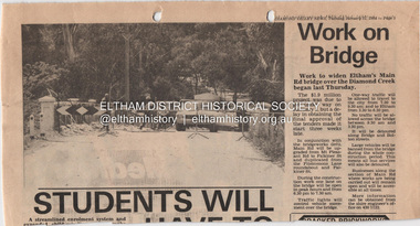 Eltham District Historical Society Inc
Document - Property Binder, Main Road Bridge, Eltham
... Main Road Bridge, Eltham...Road...Bridges...Newspaper article: Diamond Valley News, 31 January 1984, work to begin on widening of Main Road Bridge over Diamond Creek....Main Road Bridge, Eltham Document Property Binder ...Newspaper article: Diamond Valley News, 31 January 1984, work to begin on widening of Main Road Bridge over Diamond Creek.main road, bridges, main road bridge, diamond creek, eltham (vic) -
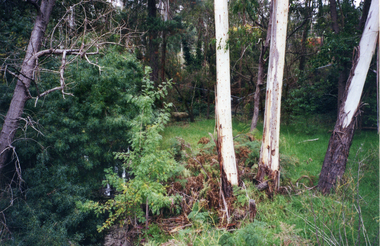
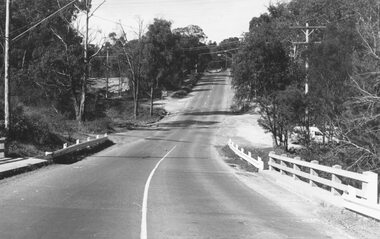
 Ringwood and District Historical Society
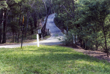
Photograph, Deep Creek Road bridge early 1900s
... Deep Creek Road bridge early 1900s....Black and white photograph taken from unmade road. Road zigzags over bridge with wooden balustrades. Bushland setting...Typed below photograph, "Deep Creek Road bridge in the early days"....Road zigzags over bridge with wooden balustrades. Bushland setting. (3 copies) Deep Creek Road bridge early 1900s. ...Black and white photograph taken from unmade road. Road zigzags over bridge with wooden balustrades. Bushland setting. (3 copies)Typed below photograph, "Deep Creek Road bridge in the early days". -
 Glenelg Shire Council Cultural Collection
Photograph - Photograph - Bridgewater Construction, n.d
... ... Bridgewater Road Bridge construction...Black and white photo of Otway street/Bridgewater road bridge under construction. Men working on scaffolding for concrete pylons, in excavated area. ...'C' 4x2 1/4 - Pencil 'Bridgewater road bridge 29/3/57 looking s.s.w'- written in blue biro. ...'C' 4x2 1/4 - Pencil 'Bridgewater road bridge 29/3/57 looking s.s.w'- written in blue biro. ...Port of Portland Authority ArchivesFront: Back- Margin ruled in pencil, diagonal in pencil. 'C' 4x2 1/4 - Pencil 'Bridgewater road bridge 29/3/57 looking s.s.w'- written in blue biro. 'Otway Street Bridge - Pencilport of portland archives, otway street bridge, bridgewater road bridge construction -
Whitehorse Historical Society Inc.
Document, Eastern Freeway Extension, 2001-2002
... ...loughnan road ringwood...bridges...Collection of papers relating to landscape concepts for Deep Creek/ Loughnan road Bridge, December 2001-March 2002. Includes Vicroads correspondence with Nunawading & District Historical Society and documents distributed to participants in public consultation meetings...Whitehorse Historical Society Inc. 2-10 Deep Creek Road Mitcham melbourne vicroads nunawading & district historical society eastern freeway extension deep creek road mitcham loughnan road ringwood bridges Collection of papers relating to landscape concepts for Deep Creek/ Loughnan road Bridge, December 2001-March 2002. ...Collection of papers relating to landscape concepts for Deep Creek/ Loughnan road Bridge, December 2001-March 2002.Collection of papers relating to landscape concepts for Deep Creek/ Loughnan road Bridge, December 2001-March 2002. Includes Vicroads correspondence with Nunawading & District Historical Society and documents distributed to participants in public consultation meetingsCollection of papers relating to landscape concepts for Deep Creek/ Loughnan road Bridge, December 2001-March 2002. vicroads, nunawading & district historical society, eastern freeway extension, deep creek road mitcham, loughnan road ringwood, bridges -
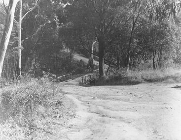
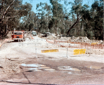 Eltham District Historical Society Inc
Photograph, Widening of Main Road Bridge over Diamond Creek, Eltham, c.1984, 1984c
... Widening of Main Road Bridge over Diamond Creek, Eltham, c.1984......main road bridge...Four colour photographs showing road works for widening of the Main Road bridge over Diamond Creek; two showing Main Road south of Mt Pleasant Road and one from the corner of Antoinette Blvd, Eltham, Vic....Widening of Main Road Bridge over Diamond Creek, Eltham, c.1984 Photograph Photograph ...Four colour photographs showing road works for widening of the Main Road bridge over Diamond Creek; two showing Main Road south of Mt Pleasant Road and one from the corner of Antoinette Blvd, Eltham, Vic.eltham, main road, diamond creek, main road bridge, bridges, construction -
 Orbost & District Historical Society
black and white photographs, C1970
... These photographs are of the 1922 road bridge across the Snowy River at Orbost. ...Two small black / white photographs of a road bridge across a river. 3248.1 is a close-up of wooden pylons....Orbost & District Historical Society Ruskin Street Orbost gippsland These photographs are of the 1922 road bridge across the Snowy River at Orbost. ...These photographs are of the 1922 road bridge across the Snowy River at Orbost. This bridge over the Snowy River was opened on July 4 1922. It was constructed in 1922 alongside the previous suspension bridge. Its building was a combined effort of the Victorian Railways and the Country Roads Board at a cost of 35,000 pounds. It was replaced in 1976 by the present bridge after several major floods.This bridge was replaced in 1976 after several major floods. These photographs are pictorial records of the 1922 brige.Two small black / white photographs of a road bridge across a river. 3248.1 is a close-up of wooden pylons.on label on back - "Snowy River Bridge at Orbost 1922 Bridge"bridge-orbost snowy-river-bridge -
 Mont De Lancey
Booklet, Department of Main Roads, Toll Roads and Bridges, 1981
... Road Tolls...Roads...Bridges...Early toll roads and bridge use in Australia from early settlement days to 1981....Green and white edging surrounds the picture with the title Toll Roads and Bridges printed in black lettering at the top right of the cover. ...Early English and USA use is mentioned. Road and bridge tolls in Australia were collected for construction and maintenance of particular roads and bridges similar to their use in England. ...A brief history of tolls used throughout history, dating back around 1950 B.C. Early English and USA use is mentioned. Road and bridge tolls in Australia were collected for construction and maintenance of particular roads and bridges similar to their use in England. The clear photographs show the development in the this country up to 1981 when the brochure was published.A small slim rectangular paperback brochure with a lithograph of the "New Toll Gate" on Parramatta Road, published in J.G. Austin's Sydney Views. Green and white edging surrounds the picture with the title Toll Roads and Bridges printed in black lettering at the top right of the cover. On the back is a photograph of Toll cabins at the northern end of the Sydney Harbour Bridge showing automatic and manual toll booths with the symbol for NAASRA and National Association of Australian State Road Authorities printed in black and white at the bottom. Pp. 20. There are many photographs inside.non-fictionA brief history of tolls used throughout history, dating back around 1950 B.C. Early English and USA use is mentioned. Road and bridge tolls in Australia were collected for construction and maintenance of particular roads and bridges similar to their use in England. The clear photographs show the development in the this country up to 1981 when the brochure was published.road tolls, roads, bridges, history of tolls -
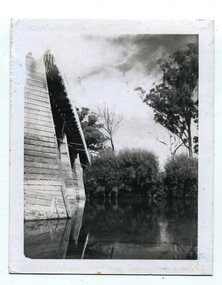
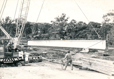
 Eltham District Historical Society Inc
Photograph, Construction of Lower Plenty Bridge, Main Road, c.August 1966, 1966
... Construction of Lower Plenty Bridge, Main Road, c.August 1966......bridge construction...main road...Construction activity of a new Main Road bridge over the Plenty River at Lower Plenty in 1966. ...Black and white photograph taken during construction of the Main Road bridge over the Plenty River. Includes structural members, construction personnel, vehicles and a Clarke mobile crane....Construction activity of a new Main Road bridge over the Plenty River at Lower Plenty in 1966. ...Construction activity of a new Main Road bridge over the Plenty River at Lower Plenty in 1966. The new bridge followed a realignment of the road and old Lower Plenty bridge remained in situ and is now part of the Plenty River Trail.Local significanceBlack and white photograph taken during construction of the Main Road bridge over the Plenty River. Includes structural members, construction personnel, vehicles and a Clarke mobile crane.mobile cranes, bridge construction, main road, plenty river, lower plenty, bridges -
 South Gippsland Shire Council
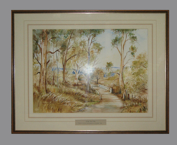
Framed watercolour painted by Bianca Biesuz, "Dryings Road Bridge", 1987
... "Dryings Road Bridge"..."Dryings Road Bridge"...Painting portrays trees with a pathway through them, white bridge, "Dryings Road Bridge" Framed watercolour painted by Bianca Biesuz ...Painted by Bianca BiesuzCream card window mount with pink edging lines. Text panel cut out lower edge. Brown wood frame with gold edging. Painting portrays trees with a pathway through them, white bridge,"Dryings Road Bridge" -
Glenelg Shire Council Cultural Collection
Photograph - Photograph - Bridge Construction, 29/05/1957
... Black and white photo of Bridgewater Road (Otway Street) bridge under construction. Site has been excavated to a depth of a several meters. ...Front: Back- 'Bridgewater road Bridge (otway street) 29/5/57' - pencil...Glenelg Shire Council Cultural Collection History House Cliff Street Portland great-ocean-road Port of Portland Authority Archives Port of Portland Front: Back- 'Bridgewater road Bridge (otway street) 29/5/57' - pencil Black and white photo of Bridgewater Road (Otway Street) bridge under construction. ...Port of Portland Authority ArchivesFront: Back- 'Bridgewater road Bridge (otway street) 29/5/57' - pencilport of portland -
 Sunshine and District Historical Society Incorporated
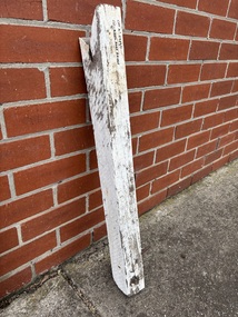
Memorabilia - Arundel Road Bridge Artefacts
... Arundel Road Bridge Artefacts...Road... Bridge...Arundel Road Bridge Artefacts...Items collected after the 2022 Maribyrnong River flood thats washed away the south half of the bridge Arundel Road Bridge Keilor Arundel Road Bridge Artefacts 1/ Wooden Railing Support Brace|2/ Metal Bolt Memorabilia Arundel Road Bridge Artefacts ...Items collected after the 2022 Maribyrnong River flood thats washed away the south half of the bridge1/ Wooden Railing Support Brace|2/ Metal BoltArundel Road Bridge Artefactsarundel road, bridge, keilor -
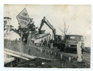 Orbost & District Historical Society
black and white photographs, 1976 - 1977
... These photographs are of the demolition of the road bridge across the Snowy River at Orbost. ...Four black / white photographs of the demolition of a road bridge across a river. In them can be seen trucks, excavators and workmen. ...Orbost & District Historical Society Ruskin Street Orbost gippsland These photographs are of the demolition of the road bridge across the Snowy River at Orbost. ...These photographs are of the demolition of the road bridge across the Snowy River at Orbost. This bridge over the Snowy River was opened on July 4 1922. It was constructed in 1922 alongside the previous suspension bridge. Its building was a combined effort of the Victorian Railways and the Country Roads Board at a cost of 35,000 pounds. It was replaced in 1976 by the present bridge after several major floods.This bridge was replaced in 1976 after several major floods. These photographs are pictorial records of its demolition.Four black / white photographs of the demolition of a road bridge across a river. In them can be seen trucks, excavators and workmen. In 3246.1 there is a triangular road sign - "LOW CLEARANCE 3.9m"bridge-demolition orbost-snwoy-river-bridge -
 Sunshine and District Historical Society Incorporated
Photograph - Raleigh Road Tram And Car Bridges Over The Maribyrnong River Photograph
... Raleigh Road Tram And Car Bridges Over The Maribyrnong River Photograph... Maribyrnong Tram Maribyrnong River Digital color photograph Photograph Raleigh Road Tram And Car Bridges Over The Maribyrnong River Photograph ...Photograph looking Southwest showing a tram travelling across the wooden trestle bridge (Now demolished) which was built when the tram line was extended from Moonee Ponds to the Maribyrnong Munitions works during WWII. The old vehicle bridge (Now demolished) and the old traffic route (Now local traffic only) can be seen on the right which ran past the front of the Anglers Hotel (Out of picture).raleigh road, maribyrnong, tram, maribyrnong river -
 Ringwood and District Historical Society
Photograph, Train Accident - Wantirna Rd Railway Bridge, Ringwood 1992
... 8.12.92 Train mishap Wantirna Road Bridge...Ringwood and District Historical Society 125A Warrandyte Road Ringwood North melbourne 8.12.92 Train mishap Wantirna Road Bridge B&W photograph taken by Ringwood Historical Research Group: Train Accident - Wantirna Rd Railway Bridge, Ringwood 1992 Photograph ...B&W photograph taken by Ringwood Historical Research Group:8.12.92 Train mishap Wantirna Road Bridge -
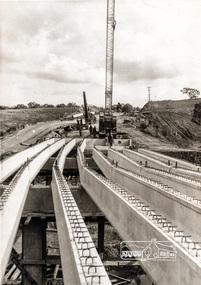
 Orbost & District Historical Society
black and white photographs, 1975
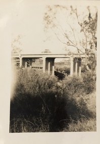
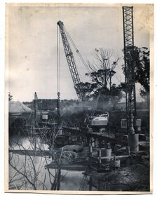
... Snowy-River-bridge-Orbost road-construction-Orbost bridge-Orbost...These are photographs of the construction of the current cement road bridge across the Snowy River at Orbost. ...Two black / white photographs showing the construction of a road bridge across a river. 3257.1 shows piles being dropped beside the bridge, 3257.2 is of the early stages of construction of this bridge....Snowy-River-bridge-Orbost road-construction-Orbost bridge-Orbost Two black / white photographs showing the construction of a road bridge across a river. 3257.1 shows piles being dropped beside the bridge, 3257.2 is of the early stages of construction of this bridge. black and white photographs ...These are photographs of the construction of the current cement road bridge across the Snowy River at Orbost. Construction of the bridges commenced in January 1975, with an expectation to open the bridge across the Snowy River as soon as possible. Less than two years later, on 25 November 1976, the bridge across the Snowy River was opened to traffic, allowing the old bridge to be demolished. The remainder of the Orbost Bypass, both the floodplain crossings and the eastern section around the township itself, was declared ‘Princes Freeway’ and opened to traffic in December 1977. (ref http://mrv.ozroads.com.au)The opening of this Snowy River Bridge was an important development in the accessibility to the township of Orbost. These photographs record its construction.Two black / white photographs showing the construction of a road bridge across a river. 3257.1 shows piles being dropped beside the bridge, 3257.2 is of the early stages of construction of this bridge.snowy-river-bridge-orbost road-construction-orbost bridge-orbost -
 Whitehorse Historical Society Inc.
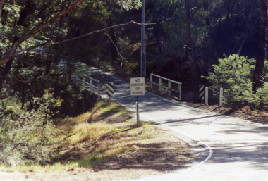
Photograph, Deep Creek Road Bridge, 18/04/2001 12:00:00 AM
... Deep Creek Road Bridge...Coloured photograph looking East from Deep Creek Road Bridge at start of construction of new Deep Creek Road Bridge....Deep Creek Road Bridge Photograph Photograph ...Coloured photograph looking East from Deep Creek Road Bridge at start of construction of new Deep Creek Road Bridge.deep creek road, mitcham, vicroads -
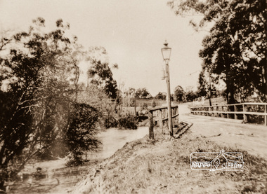 Eltham District Historical Society Inc
Photograph, Diamond Creek Bridge, Eltham North
... road...coleman crescent...bridges...The old Eltham North bridge was upstream of the present Wattletree Road bridge. ...The old Eltham North bridge was upstream of the present Wattletree Road bridge. eltham north wattletree road coleman crescent bridges Diamond Creek (Creek) Photograph copy Diamond Creek Bridge, Eltham North Photograph ...Narrow wooden bridge over a high flowing Diamond Creek at Eltham North. There is a street lamp situated in front of the bridge. The old Eltham North bridge was upstream of the present Wattletree Road bridge. Photograph copy eltham north, wattletree road, coleman crescent, bridges, diamond creek (creek) -
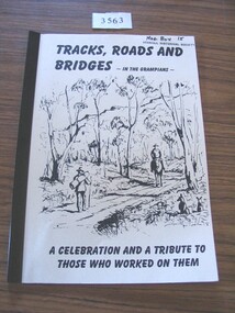 Stawell Historical Society Inc
Book, Ida Stanton, Tracks, Roads & Bridges, In the Grampians, 2002
... A History of the Roads, Tracks and Bridges in the Grampians...TRacks, Roads and Bridges - In the Grampians. A Celebration and a Tribute to those who worked on them....Stawell Historical Society Inc 46 Longfield St Stawell grampians A History of the Roads, Tracks and Bridges in the Grampians stawell TRacks, Roads and Bridges - In the Grampians. ...A History of the Roads, Tracks and Bridges in the GrampiansCrean paper cover with a line drawing of "Entering the Gap" Circa 1870 by Laurie Evans. Plastic BindingTRacks, Roads and Bridges - In the Grampians. A Celebration and a Tribute to those who worked on them.stawell -
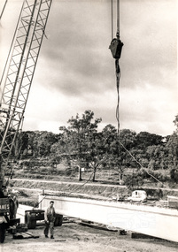
 Eltham District Historical Society Inc
Photograph, Construction of Lower Plenty Bridge, Main Road, c.August 1966, 1966
... Construction of Lower Plenty Bridge, Main Road, c.August 1966......bridge construction...main road...Construction activity of a new Main Road bridge over the Plenty River at Lower Plenty in 1966. ...Construction activity of a new Main Road bridge over the Plenty River at Lower Plenty in 1966. ...Construction activity of a new Main Road bridge over the Plenty River at Lower Plenty in 1966. The new bridge followed a realignment of the road and old Lower Plenty bridge remained in situ and is now part of the Plenty River Trail.Black and white photograph of crane lowering concrete girder into placeplenty river, bridge construction, main road, lower plenty, bridges -
 Ringwood and District Historical Society
Photograph, Two photos taken at Deep Creek Road bridge c.1973
... Two photos taken at Deep Creek Road bridge c.1973....Typed below photograph, "Deep Creek Road bridge..."...Ringwood and District Historical Society 125A Warrandyte Road Ringwood North melbourne Typed below photograph, "Deep Creek Road bridge..." Two photos taken at Deep Creek Road bridge c.1973. ...Typed below photograph, "Deep Creek Road bridge..." -
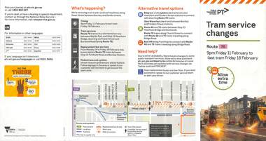 Melbourne Tram Museum
Pamphlet - Tram works on Swan St, Yarra Trams, Tram Service Changes, 2022
... ...Wallen Road bridge....1 - pamphlet provided at tram stops giving details of the works for 70 .2 - ditto - for Tram Network Upgrade - Swan St and Wallen Road Bridge, Richmond .3 - as for .1 - track reconstruction in Swan St between Stanley St and Stawell St Richmond or Burnley....1>.2 - Pamphlet - DL, four fold DL - Tram Service changes - 11/2022 to 18/2/2022 - Route 70 .3>.4 - Pamphlet - DL, four fold DL - Tram Network Upgrade - Swan St and Wallen Road Bridge, Richmond .5 - Newspaper clipping - Tram works on Swan St .6 - Pamphlet - Bridge Road and Church St - 12/3 to 14/3/2022...Melbourne Tram Museum 8 Wallen Road Hawthorn melbourne .1 - pamphlet provided at tram stops giving details of the works for 70 .2 - ditto - for Tram Network Upgrade - Swan St and Wallen Road Bridge, Richmond .3 - as for .1 - track reconstruction in Swan St between Stanley St and Stawell St Richmond or Burnley Shows the methods that Yarra Trams customers are advised of changes due to track replacement works. tram works track work Yarra Trams PTV Bridges trams tramways Richmond Burnley route 70 Wallen Road bridge .1>.2 - Pamphlet - DL, four fold DL - Tram Service changes - 11/2022 to 18/2/2022 - Route 70 .3>.4 - Pamphlet - DL, four fold DL - Tram Network Upgrade - Swan St and Wallen Road Bridge, Richmond .5 - Newspaper clipping - Tram works on Swan St .6 - Pamphlet - Bridge Road and Church St - 12/3 to 14/3/2022 Tram Service Changes Pamphlet Tram works on Swan St Yarra Trams ....1 - pamphlet provided at tram stops giving details of the works for 70 .2 - ditto - for Tram Network Upgrade - Swan St and Wallen Road Bridge, Richmond .3 - as for .1 - track reconstruction in Swan St between Stanley St and Stawell St Richmond or BurnleyShows the methods that Yarra Trams customers are advised of changes due to track replacement works..1>.2 - Pamphlet - DL, four fold DL - Tram Service changes - 11/2022 to 18/2/2022 - Route 70 .3>.4 - Pamphlet - DL, four fold DL - Tram Network Upgrade - Swan St and Wallen Road Bridge, Richmond .5 - Newspaper clipping - Tram works on Swan St .6 - Pamphlet - Bridge Road and Church St - 12/3 to 14/3/2022tram works, track work, yarra trams, ptv, bridges, trams, tramways, richmond, burnley, route 70, wallen road bridge